Practice these CPR steps to give the trout you release their best chance of survival
|
|
|
- Vincent Williams
- 6 years ago
- Views:
Transcription
1

2 Dear Trout Anglers, Thanks for choosing to trout fi sh in Wisconsin and supporting our programs by purchasing a fi shing license and trout stamp. Your investment allows us to improve habitat and conduct management activities so that Wisconsin can continue to offer the best trout fi shing in the Midwest. It has been a year of contrasts in Wisconsin that have affected trout fi shing. The good news is that we were able to increase our trout habitat restoration and maintenance program thanks to the fee increase. Maintenance is becoming a larger part of our program as some of our habitat work ages or is affected by the changes of weather and stream fl ows. Please help us by contacting the local fi sheries biologist if you notice habitat that needs maintenance. Weather played a big role in stream fl ows in the state in Parts of central and northern Wisconsin experienced continued low fl ows due to lack of precipitation, and in some cases, groundwater withdrawals. Groundwater models developed by the University of Wisconsin Stevens Point showed that groundwater pumping plays a large role in reduced stream fl ows in the Little Plover River, a class 1 trout stream in Portage County. Hopefully, the integrated advisory group that is meeting will come up with solutions that are acceptable to all parties and will maintain healthy stream fl ows. Record rainfalls in August caused fl ooding in the southwest. The areas where we have recently done stream work showed little damage, because the banks had been tapered to allow high water to overfl ow and dissipate its energy. Good news for the driftless area was the acceptance of this area as one of the fi rst National Fish Habitat Action Plan projects. That will mean increased attention and funding for restoration of southwest streams. For more information visit the web site: The VHS virus was found in Lake Michigan and Lake Winnebago in the spring of This deadly virus has not been detected in other waters at least in part due our aggressive approach to halt its spread. As I hope you know, our rules now apply statewide and require that no one remove water or live fi sh from any body of water in the state. For more information see our web site: shingwisconsin.org. Although these rules affected our hatchery and wild fi sh programs, we are working to continue stocking healthy and vibrant trout in waters that need them to provide a fi shery. Thanks for your support of our trout management in Wisconsin and I hope 2008 brings good fi shing to all. Sincerely, Lawrence Claggett Coldwater Fisheries Specialist Bureau of Fisheries Management Practice these CPR steps to give the trout you release their best chance of survival Consider Proper Release Survival of Released Trout is in Your Hands 1. Don t play fish to exhaustion. Instead, use a landing net to bring fi sh under control before they re played out. 2. Handle fish in the net. Grasp them across the back and head for fi rm but gentle control. 3. Turn fish belly up while removing hooks. This disorients fi sh momentarily for easier, quicker handling. 4. Don t remove swallowed hooks. Just cut the line next to the fi sh s mouth. 5. Don t keep fish out of the water more than seconds. Fragile gills are damaged after that, especially in cold weather. Bob Hunt Wisconsin Department of Natural Resources P.O. Box 7921 Madison, WI For fishing information or regulation updates, visit The front cover features the 2008 Trout Stamp painting by Virgil Beck Pamphlet prepared by Larry Claggett Layout by Jeanne Gomoll, Union Street Design, LLC Maps by Alex Martin and DNR Geographical Services
3 Your Guide to Regulations and Better Trout Fishing This guide is specifi c to inland (including streams that fl ow into the Great Lakes) trout fi shing. For general fi shing rules, which also apply to trout fi shing, refer to the Guide to Wisconsin Hook and Line Fishing Regulations (Publication FH ). The regulations in this pamphlet are effective March 1, 2008 through February 28, Note: New rules prohibit transporting any live fi sh or water away from any water of the state. For more information, see the Guide to Wisconsin Hook and Line Fishing Regulations. It is illegal to fi sh without a Wisconsin fi shing license or stamp as required. You must have an inland trout stamp if you need a fi shing license and intend to fi sh for trout in inland waters, including streams fl owing into Lake Superior. You need a Great Lakes trout and salmon stamp to fi sh for trout and salmon in streams that fl ow into Green Bay and Lake Michigan from their mouths up to the fi rst dam or lake (including specifi c waters listed above). to fi sh for any species of fi sh in trout streams when the trout season is closed except that rough fi sh may be taken by hand. to use or release minnows on rehabilitated trout lakes that are identifi ed with posted signs. to possess any live bait or any other baits, hooks or lures other than artifi cial lures while on the waters, banks or shores of waters where only the use of artifi - cial lures is allowed. to remove insect larvae from any trout stream or spring hole tributary to a trout stream for use or sale as bait except that a licensed angler may take insect larvae or nymphs from trout streams by hand during the open trout season for their immediate personal use as bait in the stream from which taken and all such larvae or nymphs must be returned to the stream prior to leaving the stream from which taken. By hand means no use of small seines or nets or other devices. Seasons and Possession Limits The regular open season for all waters, including lakes, is May 3 at 5:00 a.m. through September 30 except as listed in the specifi c waters listed by county. While on the water, bank, or shore you may only possess the number and size of fi sh allowed for that portion of water. You may fi sh more than one water in a day but may not possess more than the daily bag and size limits for the water you are on. The total number of fi sh you may have at home or camp from all waters fi shed is 10 trout, of which only 5 can be a combined total of browns and rainbows, except for streams that fl ow into the Great Lakes. For streams that fl ow into Lake Michigan and Lake Superior the possession limit is twice the daily bag limit. There is an early catch and release season for trout from March 1, 2008 at 5:00 a.m. until April 27 at midnight on the waters listed in 1 through 19 below: The daily bag limit and possession limit for trout during this period is 0 (all trout caught shall be immediately released) and only artifi cial lures with barbless hooks may be used while fi shing for any species of fi sh on trout streams during this early season. The early season does not apply to spring ponds, ponds, lakes, Lake Michigan tributaries, major Green Bay tributaries, all other tributary streams, rivers and ditches to Green Bay upstream to the fi rst dam or lake, or streams fl owing into Lake Superior and their tributaries upstream to the fi rst impassible barrier. Early Season Streams Open 1. All streams in Adams, Barron, Buffalo, Burnett, Chippewa, Clark, Columbia, Crawford, Dane, Dodge, Dunn, Eau Claire, Fond du Lac, Grant, Green, Green Lake, Iowa, Jackson, Jefferson, Juneau, Kenosha, La Crosse, Lafayette, Milwaukee, Monroe, Ozaukee, Pepin, Pierce, Polk, Price, Racine, Richland, Rock, Rusk, St. Croix, Sauk, Sawyer, Sheboygan, Taylor, Treampealeau, Vernon, Walworth, Washburn, Washington, Waukesha and Wood Counties. 2. Ashland county All streams except streams and their tributaries fl owing into Lake Superior upstream to the fi rst impassable barrier. 3. Bayfi eld county All streams except streams and their tributaries fl owing into Lake Superior upstream to the fi rst impassable barrier and the White river and its tributaries upstream from Pike River Road bridge. 4. Douglas county All streams except streams and their tributaries fl owing into Lake Superior upstream to the fi rst impassable barrier. 5. Florence county Pine river. 6. Forest county Peshtigo river downstream from U.S. highway 8, Pine river downstream from STH 55, and Rat river downstream from Scattered Rice lake. 7. Iron county All streams except streams and their tributaries fl owing into Lake Superior upstream to the fi rst impassable barrier. 8. Langlade county Wolf river. 9. Lincoln county All streams west of STH 51 and Prairie river downstream from CTH J. 10. Marathon county Black creek (mouth at T27N R7E S4), Black creek (T30N,R3E), Grass creek, McGinnes creek, Fourmile creek, Noisy creek, and Plover river from STH 29 downstream to STH Marinette county North branch Peme Bon Won river downstream from STH 141, Peshtigo river upstream from CTH C, Pike river between CTH V and CTH K, and Rat river. 12. Marquette county Chaffee creek downstream from CTH B, Klawitter creek, Lawrence creek, Lunch creek, Mecan river upstream from STH 22, Neenah creek, O Keefe creek, Wedde creek and Westfi eld creek. 13. Oconto county North branch Oconto river downstream from STH 64 and south branch Oconto river downstream from CTH AA. 14. Oneida county All streams west of STH 51 and Bearskin creek. 15. Portage county Ditches 1 through 6 downstream from Townline road and Tomorrow river from Amherst downstream to Durant road. 16. Shawano county Middle branch Embarrass river from Homme dam to STH 29, north branch Embarrass river from Tilleda dam downstream to Leopolis dam and Red river downstream from lower Red Lake dam. 17. Vilas county Mishonagon creek. 18. Waupaca county North branch Little Wolf river from CTH P to CTH J, south branch Little Wolf river, and Waupaca river from Frost Valley road to STH Waushara county Carter creek, Leola ditch, Mecan river downstream from 11 th Road, Pine river downstream from CTH K to Poy Sippi pond, Roche-a-Cri creek, Willow creek from Blackhawk Road to 29 th Lane, and White river from STH 21 to lower White River millpond.
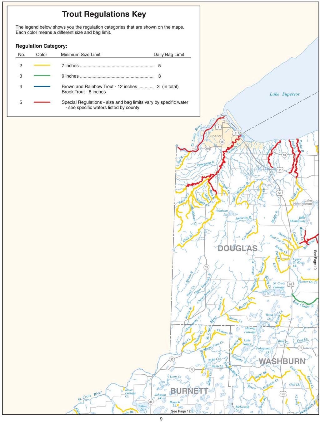
4 Lake Michigan Streams Except as otherwise specified, all streams flowing into Lake Michigan and Green Bay have the following regulations from their mouths upstream to the first dam or lake; including the Little River from its confluence with the Oconto River upstream to the STH 141 bridge; the entire Kewaunee River and its tributaries except Little Scarboro Creek, Scarboro Creek, Roger Creek and Casco Creek; the Milwaukee River upstream to the Grafton Dam in the village of Grafton and tributaries of the Milwaukee River upstream to the first dam or lake; the Menomonee River upstream to the Lepper Dam in the village of Menomonee Falls and tributaries of the Menomonee River upstream to the first dam or lake; and the Pike River and its tributaries in Kenosha and Racine counties: Open season: all year on Lake Michigan tributaries and the following stream sections of Green Bay tributaries: Duck Creek (Brown Co.), from the first dam above the Pamperin Park footbridge (Village of Howard) downstream to Green Bay; Suamico River (Brown Co.), from the CTH HS bridge downstream to Green Bay; East River (Brown Co.), from the CTH XX (Hoffman Road) bridge downstream to the Fox River; Little Suamico River (Oconto Co.), from the CTH J bridge downstream to Green Bay; Pensaukee River (Oconto Co.), from the CTH J bridge downstream to Green Bay; Oconto River (Oconto Co.), from the Stiles dam downstream to Green Bay; Little River (Oconto Co.), from the Highway 141 bridge downstream to the Oconto River; Little River (Marinette Co.), from the Rader Road bridge downstream to Green Bay; and Peshtigo River (Marinette Co.), from the Peshtigo dam downstream to Green Bay. (NOTE: there is no hook and line fishing allowed for any species on all other Green Bay and Fox River tributaries and ditches, including tributaries to the above streams, from their mouth up to the first dam or lake from the first Sunday in March to the first Saturday in May. The open season on other Green Bay tributaries is from the first Saturday in May to the first Sunday in March. Open season for lake trout: March 1 through October 31 on Lake Michigan tributaries and the following stream sections of Green Bay tributaries: Duck Creek (Brown Co.), from the first dam above the Pamperin Park footbridge (Village of Howard) downstream to Green Bay; Suamico River (Brown Co.), from the CTH HS bridge downstream to Green Bay; East River (Brown Co.), from the CTH XX (Hoffman Road) bridge downstream to the Fox River; Little Suamico River (Oconto Co.), from the CTH J bridge downstream to Green Bay; Pensaukee River (Oconto Co.), from the CTH J bridge downstream to Green Bay; Oconto River (Oconto Co.), from the Stiles dam downstream to Green Bay; Little River (Oconto Co.), from the Highway 141 bridge downstream to the Oconto River; Little River (Marinette Co.), from the Rader Road bridge downstream to Green Bay; and Peshtigo River (Marinette Co.), from the Peshtigo dam downstream to Green Bay. The season for lake trout on all other Green Bay tributaries and ditches including tributaries to the sections of above named streams is the first Saturday in May to October 31. Daily bag limit: 5 trout and salmon in total, only 2 may be lake trout Size limit: 10" Hours: From September 15 to May 3, hook and line fi shing is prohibited from one-half hour after sunset to one-half hour before sunrise in all tributaries except the Peshtigo River from the mouth upstream to the fi rst railroad bridge and the Oconto River and its tributaries. This restriction does apply to the Little river downstream from Highway 141. From September 15 to December 31, fishing by any method prohibited from ½ hour after sunset to ½ hour before sunrise on all tributaries and ditches to Green Bay and Lake Michigan including the Peshtigo River upstream from the first railroad bridge to the first dam, and the Little River downstream from Highway Lake Superior Streams (all are located in Ashland, Bayfield, Douglas and Iron Counties) All streams fl owing into Lake Superior have the following regulations from their mouths upstream to the fi rst impassable permanent barrier unless listed in specifi c waters listed by county: Open season: May 3 at 5:00 a.m. to September 30 Daily bag limit: 5 trout and salmon in total, only 2 of which may be brown trout over 15" and only 1 of which may be a rainbow trout Size limit: brook trout 8", brown trout 10", salmon 12", & rainbow trout Size and Bag Limits To determine the regulations where you will be fi shing, follow these steps: 1. Find the county in which you intend to fi sh. 2. In the listing for that county, locate the lake or stream you intend to fi sh (listed alphabetically) to determine the regulation category. 3. If the lake or stream is not listed, refer to the category listed immediately following the county name for all waters not listed. 4. Refer to the regulation key below to determine size and bag limits for categories 2-4. Read the special regulations if category 5 applies. Trout Regulations Key The table below shows you the regulation categories that are listed in the specifi c waters listed by county. Each number (or color on the map) means a different size and bag limit. Category Number Category Color Minimum Size Daily Bag 2 Yellow 7 inches 5 3 Green 9 inches 3 4 Blue Brown and rainbow trout 12 3 inches; Brook trout 8 inches 5 Red Special regulations size and bag limits vary by specifi c water see specifi c waters listed by county Abbreviations and Explanations: STH = state highway CTH = county highway USH = United States highway Artifi cial lure means a spoon, spinner, plug or other fi sh bait made of hair, feathers, cork, wood, rubber, metal, plastic or other synthetic materials, or combinations of these materials. An artifi cial lure may not include natural or organic food stuffs such as corn, marshmallows, dough, cheese, meat, living or dead organisms or parts thereof, except hair, feathers, cork, wood and rubber. Urban waters are lakes and ponds which are intensively and cooperatively managed with a municipality. They are posted with signs and have a large part of the shoreline open for public access. A complete list is available from the Southeast Regional office. Only persons under age 16 or who have certain disabilities may fish in urban waters from March 8 to April 25. Some waters have seasons, size and bag limits for trout, but are not designated trout streams. Most tribal or federal lands located within Native American reservations are not open for recreational use. Access to streams or lakes on Native American reservations must be with the permission of the landowner or from lands open to the public such as public roads. Entering or fi shing from tribal lands could subject you to tribal or federal trespass laws.
5 Specific Waters Listed By County ADAMS BIG ROCHE A CRI CREEK Big Roche a Cri Lake upstream to CTH W Category 4 DEEP LAKE Category 3 EAST CASTLE ROCK DITCH Category 3 FAIRBANKS CREEK Category 4 FORDHAM CREEK Category 5 Daily Bag and Size Limit: 5 trout under 8", or 4 trout under 8" & 1 over 12" JORDAN LAKE Category 3 LITTLE ROCHE A CRI CREEK Category 5 Daily Bag and Size Limit: 5 trout under 8", or 4 trout under 8" & 1 over 12" NEENAH CREEK (UPPER) Category 5 Daily Bag Limit: 2 trout Size Limit: 14" Gear Restrictions: Only artifi cial lures may be used PARKER LAKE Category 3 WHITE CREEK (CAMPBELL) CTH Z upstream to Easton dam Category 5 Daily Bag Limit: 1 trout Size Limit: 15" WOLF LAKE Category 3 ASHLAND For streams fl owing into Lake Superior that are not listed see the regulations under Lake Superior Streams on page 2. BAD RIVER Downstream from Devil s Gate Category 5 Size Limit: brook trout 8", brown trout 10", salmon 12" & rainbow trout BEAVER LAKE Category 2 BRUNSWEILLER RIVER Downstream from STH 13 Category 5 Size Limit: brook trout 8", brown trout 10", salmon 12" & rainbow trout CAMMERER LAKE Category 2 DEVIL S CREEK Category 3 FRAMES CREEK Category 3 MARENGO RIVER Downstream from STH 13 Category 5 Size Limit: brook trout 8", brown trout 10", salmon 12" & rainbow trout POLE LAKE Category 2 POTATO RIVER Category 5 Size Limit: brook trout 8", brown trout 10", salmon 12" & rainbow trout SPRING BROOK Category 3 3 WABOO CREEK Category 3 WHITE RIVER Downstream from White River dam Category 5 Size Limit: brook trout 8", brown trout 10", salmon 12" & rainbow trout BARRON BEAVER DAM LAKE Category 5 Daily Bag Limit: 1 trout Size limit: BRILL RIVER Category 4 CONNORS CREEK Category 4 HAY RIVER Category 5 Daily Bag Limit: 1 trout Size Limit 15" LITTLE GRANITE LAKE Category 2 LITTLE VANCE CREEK Category 4 SOUTH FORK HAY RIVER Category 4 SILVER LAKE Category 2 UPPER PINE CREEK Downstream from Dallas Flowage Category 4 VANCE CREEK Category 4 BAYFIELD For streams fl owing into Lake Superior that are not listed see the regulations under Lake Superior Streams on page 2. BALSAM POND Category 2 Open Season: Closed in Open in odd-numbered years only. BARK RIVER AND ALL ITS TRIBUTARIES Category 5 Open Season: May 3 at 5:00 a.m. to November 15 trout over 15", only 1 of which may be a rainbow trout, and all brook trout caught shall be immediately released Size Limit: brown trout 10", salmon 12", & rainbow trout BEAVER LAKE Category 2 Closed in Open in odd-numbered years only. BONO CREEK Category 5 Open Season: May 3 at 5:00 a.m. to November 15 BOYD CREEK Category 5 Open Season: May 3 at 5:00 a.m. to November 15 CAP CREEK Category 5 CRANBERRY RIVER Downstream from Lenawee Road (S28, T50N, R7W) Category 5 FISH CREEK (NORTH FORK) Downstream from Pine Creek (S13, T47N, R6W) Category 5
6 FLAG RIVER Downstream from East Fork of Flag River Category 5 IRON RIVER Downstream from the sea lamprey barrier at the former site of the Orienta Dam Category 5 IRON RIVER Upstream from the sea lamprey barrier at the former site of the Orienta Dam Category 3 IRON RIVER (EAST FORK) Downstream from Sorenson Road Category 3 LITTLE SIOUX RIVER downstream from falls in NE1/4 of the NE1/4, S13, T49N, R5W Category 5 Open Season: May 3 at 5:00 a.m. to September 30 LITTLE STAR LAKE Category 2 Open Season: Closed in Open in odd-numbered years only. LONG LAKE BRANCH OF WHITE RIVER Downstream from Taylor Lane Category 5 Daily Bag and Size Limit: 3 trout over 9", only 1 brown trout over 15" NAMEKAGON RIVER Downstream to Pacawong dam (Sawyer County) Category 3 NYMPHIA LAKE Category 2 Open Season: May 3 at 5:00 a.m. to September 30, Closed in odd-numbered years. ONION RIVER Downstream from Lake Superior district Power Company power line (S6, T49N, R4W) Category 5 Open Season: May 3 at 5:00 a.m. to November 15 OVERBY LAKE (BLAISDELL LAKE) Category 2 Open Season: May 3 at 5:00 a.m. to September 30, Closed in odd-numbered years. PERCH LAKE Category 2 PIKES CREEK Downstream from the Red Dam Category 5 Open Season: May 3 at 5:00 a.m. to November 15 PINE CREEK Downstream from junction with Little Pine Creek (S11,T47N,R6W) Category 5 Open Season: May 3 at 5:00 a.m. to November 15 SCHULTZ SPRINGS Category 5 SIOUX RIVER Downstream from Big Rock Falls (S19, T49N, R4W) Category 5 SISKIWIT RIVER Downstream from second bridge from mouth (S35, T51N, R6W) Category 5 SPRING LAKE (S28, T44N, R9W) Category 2 Open Season: Closed in Open in odd-numbered years only. WANOKA LAKE Category 2 WHITE RIVER Upstream from Pikes Bridge Category 2 Open Season: May 3 at 5:00 a.m. to Sept. 30 WHITE RIVER Downstream from Pikes Bridge to White River Dam Category 5 Daily Bag and Size Limit: 3 trout over 9", only 1 brown trout over 15" WHITE RIVER (EAST FORK) Category 2 Open Season: May 3 at 5:00 a.m. to Sept. 30 WHITE RIVER (SOUTH FORK & SPRINGS) Category 2 Open season: May 3 at 5:00 a.m. to Sept. 30 WHITE RIVER (UNNAMED TRIBUTARIES) Category 2 Open season: May 3 at 5:00 a.m. to Sept. 30 WHITE RIVER (WEST FORK) Category 2 Open Season: May 3 at 5:00 a.m. to Sept. 30 WHITTLESEY CREEK AND ALL ITS TRIBUTARIES Downstream from Town Hall Road Category 5 Open Season: May 3 at 5:00 a.m. to November 15 trout over 15", only 1 of which may be a rainbow trout, and all brook trout caught shall be immediately released Size Limit: brown trout 10", salmon 12", & rainbow trout BROWN For streams fl owing into Green Bay see regulations under Lake Michigan Streams on page 2. HALLER CREEK Category 5 Daily Bag Limit: 3 trout Size Limit: None BUFFALO ALL WATERS NOT LISTED Category 3 CENTER CREEK Category 4 GILMANTON POND Category 2 LITTLE BEAR Category 4 LITTLE BEAR (NORTH BRANCH) Category 4 MIRROR LAKE Category 2 NEWTON VALLEY CREEK Category 4 NORWEGIAN VALLEY CREEK Category 4 OWEN VALLEY CREEK Category 4 SPRING CREEK Category 4 TAMARACK (MODENA) CREEK Upstream from CTH J (S23, T23N, R12W) Category 3 TRAVERSE VALLEY CREEK Category 4 UNAMED CREEK 5-9 Category 4 WAUMANDEE CREEK (BIG) Upstream from CTH U (S25, T22N, R11W) Category 4 WAUMANDEE CREEK (LITTLE) Upstream from CTH E at Cream Category 4 WEISENBECK VALLEY CREEK Category 4 BURNETT CLAM RIVER (NORTH FORK) Washburn County line downstream to Clam Lake Category 5 Size Limit: all trout kept shall be less than 12" 4
7 CLAM RIVER (SOUTH FORK) Category 5 Size Limit: all trout kept shall be less than 12" CLAM RIVER SPRINGS Category 5 Size Limit: all trout kept shall be less than 12" INDIAN CREEK Category 5 Size Limit: all trout kept shall be less than 12" KRANTZ CREEK Category 5 Size Limit: all trout kept shall be less than 12" SAND CREEK Category 5 Size Limit: all trout kept shall be less than 12" SPENCER CREEK Category 5 Size Limit: all trout kept shall be less than 12" SPRING BROOK Category 5 Size Limit: all trout kept shall be less than 12" CALUMET ROUND LAKE Category 2 CHIPPEWA ALL WATERS NOT LISTED Category 4 BIG ELK CREEK Category 5 Daily Bag Limit: 3 Size Limit: 8" BRADLEY LAKE Category 3 DARK LAKE Category 3 DUNCAN CREEK Upstream from Bloomer Dam Category 5 Daily Bag Limit: 5 trout under 10", or 4 trout under 10" and 1 over 14" DUNCAN CREEK Downstream of Bloomer Dam Category 5 Daily Bag Limit: 3 Size Limit: 8" Open for fi shing warmwater fi sh consistent with warmwater seasons ELK CREEK Category 5 Daily Bag Limit: 3 trout under 10", or 2 under 10" and 1 over 14" HAY CREEK (WOODMOHR TOWNSHIP) Category 5 Daily Bag Limit: 3 Size Limit: 8" HENNEMAN LAKE Category 3 UNNAMED CREEK Category 5 Daily Bag Limit: 3 trout under 10", or 2 under 10" and 1 over 14" UNNAMED CREEK 5-16 Category 5 Daily Bag Limit: 3 Size Limit: 8" UNNAMED CREEK Category 5 Daily Bag Limit: 3 Size Limit: 8" UNNAMED CREEK Category 5 Daily Bag Limit: 3 Size Limit: 8" CLARK ALL WATERS Category 2 COLUMBIA ALL WATERS NOT LISTED Category 3 LODI SPRING CREEK Lodi sewer plant downstream to fi rst STH 113 bridge Category 5 Daily Bag Limit: 1 trout Size Limit: 15" ROWLEY CREEK Category 4 CRAWFORD ALL WATERS Category 3 BOYDTOWN CREEK (S2, T7N, R4W) Category 5 BUCK CREEK (S22, T10N, R6W) Category 5 DUCHARME CREEK (S18, T18N, R6W) Category 5 PICATEE CREEK (S25, T8N, R7W) Category 5 UNNAMED CREEK 1-3 (S1, T7N, R7W) Category 5 UNNAMED CREEK 2-15 (S2, T9N, R6W) Category 5 UNNAMED CREEK 33-8 (S33, T9N, R6W) Category 5 DANE ALL STREAMS NOT LISTED Category 3 ALL LAKES AND PONDS Category 3 All Dane County lakes and ponds have an open season from January 1 to September 30 BLACK EARTH CREEK Park Street immediately east of the village of Black Earth upstream to South Valley Road. Category 5 MOUNT VERNON CREEK Posted area between CTH U and STH 92 Category 5 DODGE ALL WATERS Category 3 DOOR ALL WATERS Category 2 For streams fl owing into Lake Michigan and Green Bay see the regulations under Lake Michigan Streams on p. 2. DOUGLAS For streams fl owing into Lake Superior that are not listed see the regulations under Lake Superior Streams on page 2. AMNICON RIVER Downstream from Amnicon Falls Category 5 Size Limit: brook trout 8", brown trout 10", salmon 12",& rainbow trout 5
8 BRULE RIVER Downstream from USH 2 Category 5 Fishing hours: fi shing prohibited from 1/2 hour after sunset to 1/2 hour before sunrise from March 29 to May 3 and from October 1 to November 15, and from 12:01 a.m. to 5:00 a.m. May 3 BRULE RIVER CTH S downstream to CTH B Category 5 Open Season: May 3 at 5:00 a.m. to September 30 Daily Bag Limit: 3 trout and salmon in total, only 2 of which may be brown trout and only 1 of which may be a rainbow trout Size Limit: brook trout 10", brown trout 15", salmon 12", & rainbow trout BRULE RIVER Remainder not covered above Category 5 Open Season: May 3 at 5:00 a.m. to September 30 trout over 15" and only 1 of which may a rainbow trout BLACK RIVER Downstream from Big Manitou Falls Category 5 EAU CLAIRE RIVER Category 3 MIDDLE RIVER Downstream from USH 2 Category 5 NEMADJI RIVER Downstream from Great Northern RR Bridge (S4,T47N,14W) Category 5 POPLAR RIVER Downstream from USH 2 Category 5 ST. LOUIS RIVER Downstream from Wisconsin-Minnesota state line Category 5 DUNN ALL WATERS NOT LISTED Category 4 BIG ELK CREEK Category 5 Daily Bag Limit: 3 trout Size Limit: 8" ELK CREEK Category 5 Daily Bag and Size Limit: 3 trout under 10", or 2 trout under 10" and 1 over 14" KNAPP POND Category 5 Daily Bag Limit: 3 trout Size Limit: None PINE CREEK (LOWER AND SOUTH FORK LOWER) Category 2 UNNAMED CREEK Category 5 Daily Bag Limit: 3 trout Size Limit: 8" 6 EAU CLAIRE ADAMS CREEK Category 3 BEAR GRASS CREEK Category 4 BIG CREEK Category 3 BRIDGE CREEK Including Rodell Millpond Category 3 CLEAR CREEK Category 4 COON CREEK Category 4 DIAMOND VALLEY CREEK Category 3 ELK CREEK Category 5 Daily Bag and Size Limit: 3 trout under 10", or 2 trout under 10" and 1 over 14" FALL CREEK Including Fall Creek Pond Category 5 Daily Bag Limit: 3 Size Limit: 8" GRAHAM CREEK Category 4 LINDSAY CREEK Category 3 LOWES CREEK Category 3 OTTER CREEK Category 3 PEESO (HOYTS) CREEK Category 3 PINE CREEK (Town of Clear Creek) Category 3 ROCK CREEK Category 4 SWAN CREEK Category 4 THOMPSON VALLEY CREEK Category 3 FLORENCE ANNA LAKE Category 2 BRULE RIVER Upstream from USH 2 Category 5 Open Season: April 26 to September 30 Daily Bag Limit: 5 trout Size Limit: brown trout 12", brook trout 8" BRULE RIVER Downstream from USH 2 Category 5 Open Season: April 26 to September 30 Daily Bag Limit: 5 trout Size Limit: 7" EDITH LAKE Category 3 FISHER LAKE Category 2 KEYES LAKE Category 5 Daily Bag Limit: 3 trout in total, only 2 of which may be brown trout and only 1 of which may be lake trout Size Limit: brown trout 12, lake trout LAMONTAGNE CREEK Category 4 LOST LAKE Category 3 MONTGOMERY LAKE Category 2 PATTEN LAKE Category 2 PINE RIVER Downstream from STH 139 Category 4 PINE RIVER FLOWAGE Category 2 SAND LAKE (T39N, R18E, S13) Category 3 SOUTH RILEY LAKE Category 3 WISCONSIN CREEK Category 4 WOODS CREEK Category 4 FOND DU LAC ALL WATERS Category 3 FOREST BRULE CREEK Downstream from Fishel Road (USFS ROAD #2193) Category 4
9 BRULE RIVER Category 5 Open season: April 26 at 5:00 a.m. to September 30 Daily Bag Limit: 5 trout Size Limit: brown trout 12:, brook trout 8" ELVOY CREEK Downstream from Kaine Road (USFS ROAD #2461) Category 4 ELVOY SPRINGS (S20, T41N, R13E) Category 4 LITTLE CUB LAKE Category 5 Daily Bag Limit: 5 trout Size Limit: none LUCERNE LAKE Category 5 Open Season: lake trout May 3 at 5:00 a.m. to September 30, other trout May 3 at 5:00 a.m. to March 1, Daily Bag Limit lake trout 1, brown trout 2, Size Limit: lake trout, brown trout 12" PESHTIGO RIVER Downstream from STH 8 Category 3 Open season: May 3 at 5:00 a.m. to September 30, the following restrictions apply: Daily Bag Limit: 3 trout Size Limit: 9" Open season: October 1 through November 15, the following restrictions apply: GRANT ALL WATERS NOT LISTED Category 3 BIG GREEN RIVER STH 133 upstream to CTH T Category 5 BIG GREEN RIVER Upstream from CTH T Category 5 Daily Bag Limit: 3 trout in total Size Limit: all trout kept shall be between 10" and 13" BIG SPRING BRANCH Downstream of Pine Tree Road Category 5 Daily Bag Limit: 2 trout BIG SPRING BRANCH Pine Tree Road upstream to county line Category 5 BLUE RIVER Biba Road Upstream to Snow bottom Road Category 5 Daily Bag Limit: 2 trout BLUE RIVER Snow Bottom Road upstream to county line Category 5 CASTLE ROCK CREEK Witek Road upstream to second CTH Q bridge Category 5 CASTLE ROCK CREEK AND SPRING Church Road downstream to second CTH Q bridge Category 5 CROOKED CREEK Category 5 Daily Bag Limit: 3 trout in total Size Limit: all trout kept shall be between 10" and 13" DOC SMITH BRANCH From Castle Rock Creek upstream to 0.5 mile upstream from Everson Road Category 5 GRANT RIVER CTH A upstream to CTH K Category 5 LITTLE GRANT RIVER Govier Road upstream to Milner Road Category 5 LITTLE PLATTE RIVER Waterfall Road upstream to STH 80 Category 5 MILLVILLE CREEK Category 5 SIX MILE BRANCH Downstream from Pine Tree Road Category 5 GREEN ALL WATERS Category 3 GREEN LAKE GREEN LAKE AND ITS TRIBUTARIES UPSTREAM TO FIRST DAM Category 5 Open Season: lake trout January 5 to September 30, 2008 (January 3 to September 30, 2009). Other trout May 3 at 5:00 a.m. to March 1, It is illegal to fi sh through the ice using minnows (dead or alive or as cut bait) in water 50 or more feet deep (measured from surface to bottom) Daily Bag Limit: 2 lake trout, 3 other trout Size Limit: lake trout 17", other trout 14" IOWA ALL WATERS NOT LISTED Category 3 BAKER CREEK Category 5 BIG SPRING CREEK Category 5 BLUE RIVER County line upstream to 0.5 mile upstream of Blue River Road Category 5 CAVE HOLLOW CREEK Category 5 GORDON CREEK West Moscow Road upstream to Brue Road Category 5 Gear Restriction: None GORDON CREEK Lowermost Brue Road upstream to Spring Creek Road Category 5 MILL CREEK Mill Road downstream to CTH H Category 5 Gear Restriction: None OTTER CREEK CTH II Upstream to Plank Road Category 5 OTTER CREEK Upstream from Mt. Hope Road Category 5 POMPEY PILLAR CREEK Downstream from CTH I Category 5 POMPEY PILLAR CREEK Upstream from CTH I Category 5 SMOKEY HOLLOW CREEK Downstream from CTH P Category 5 7
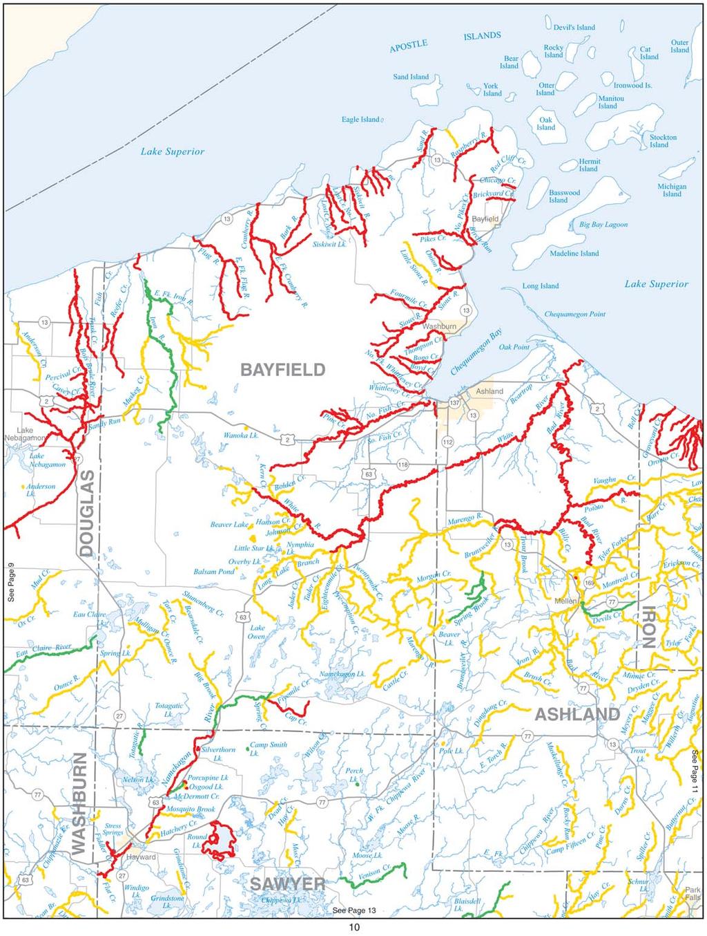
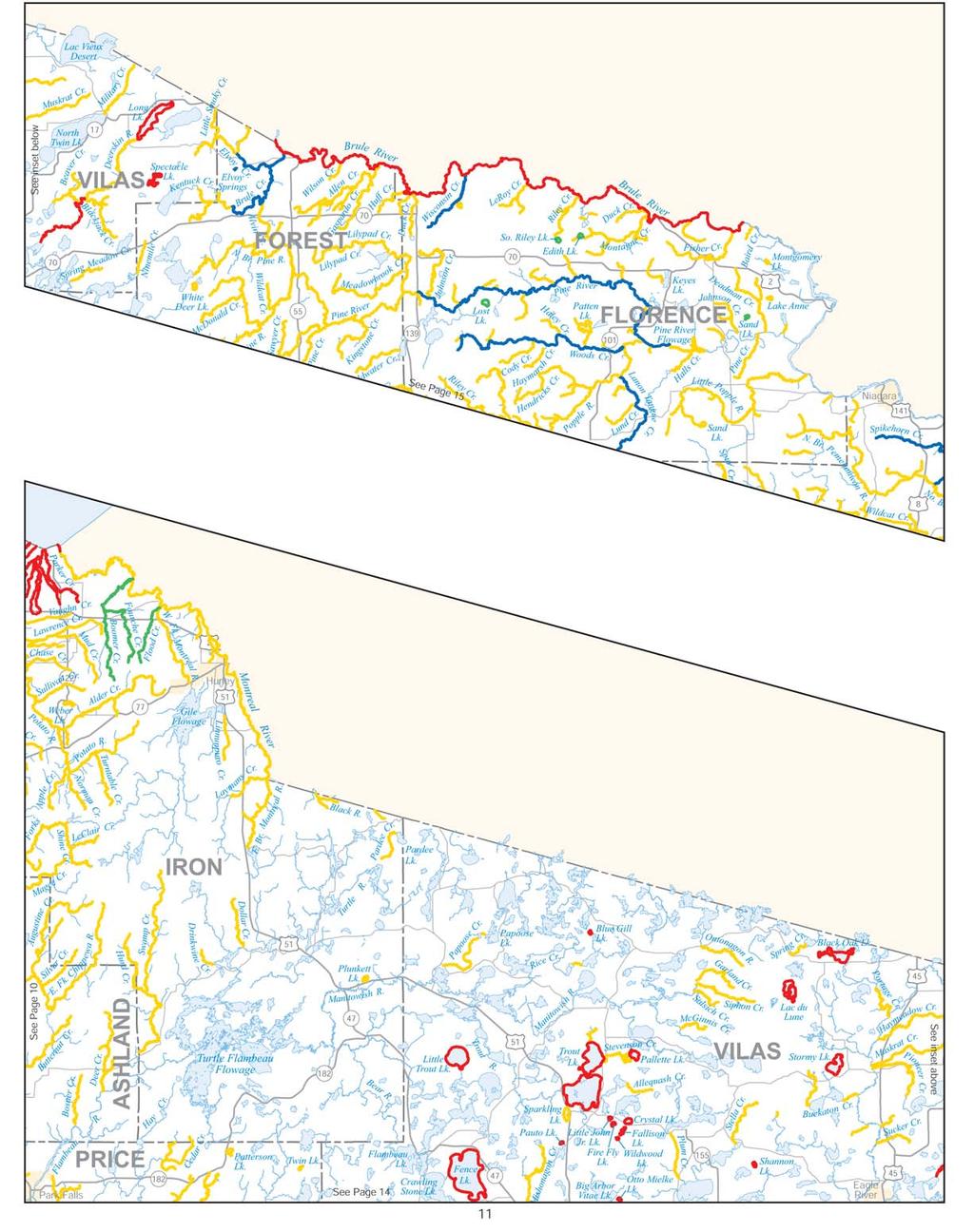
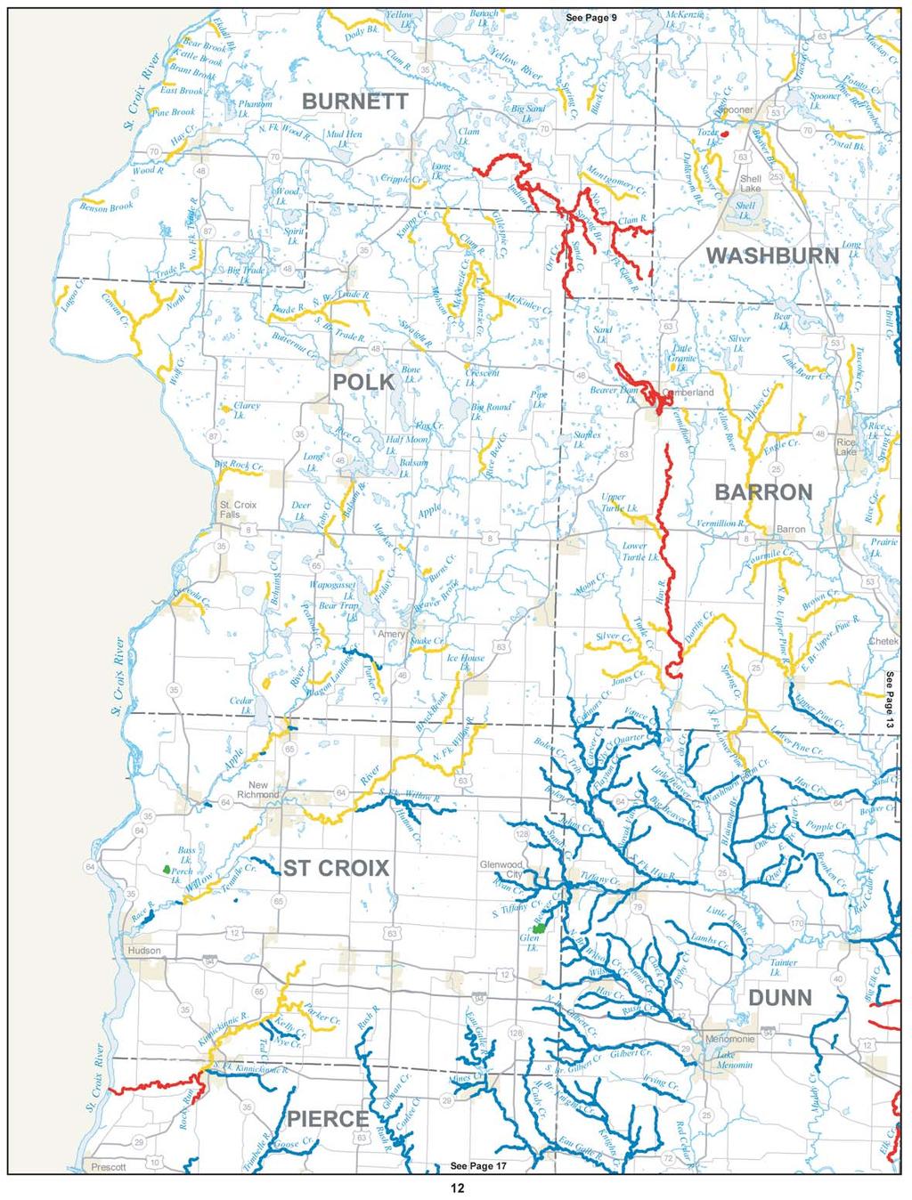
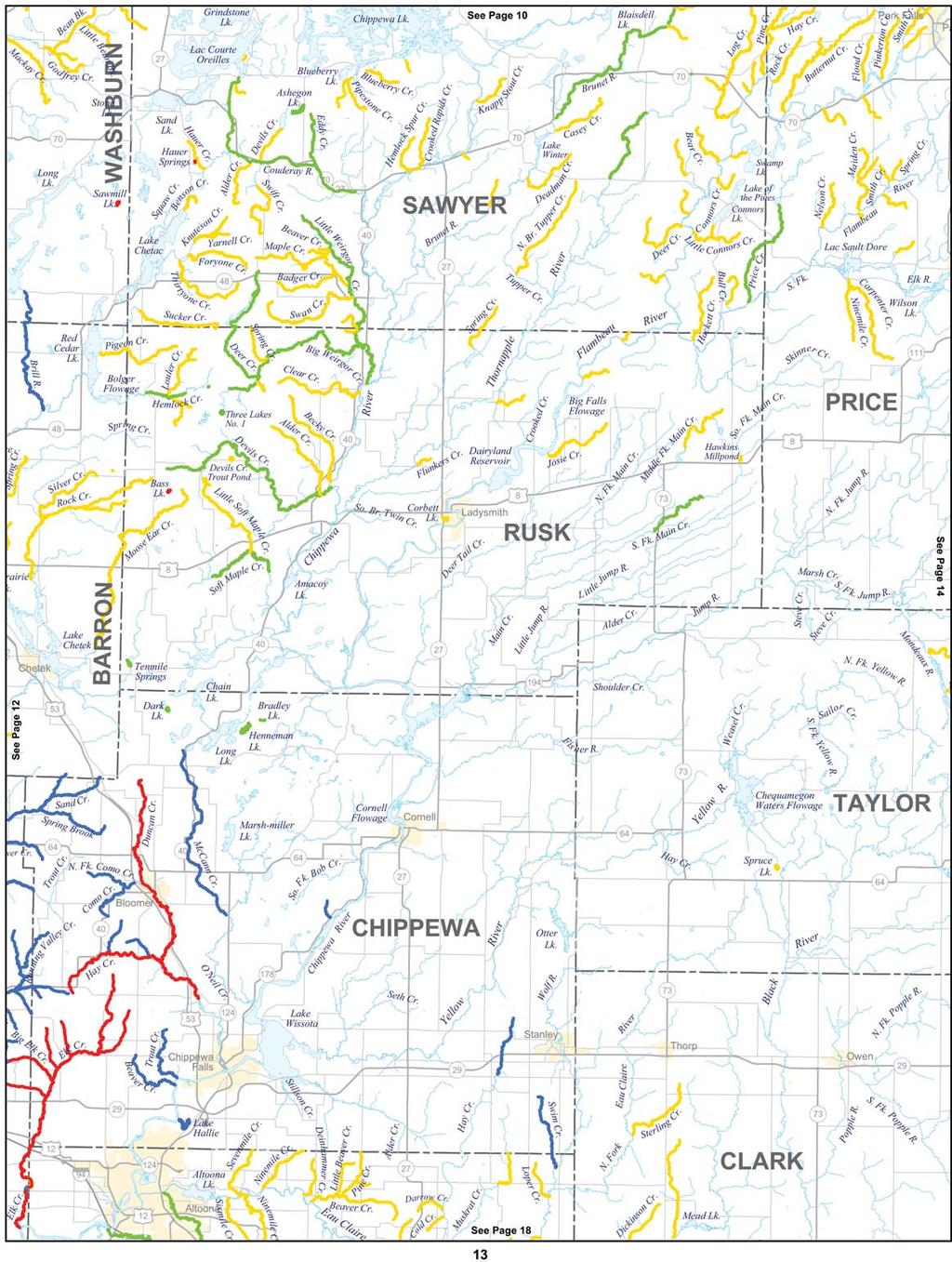
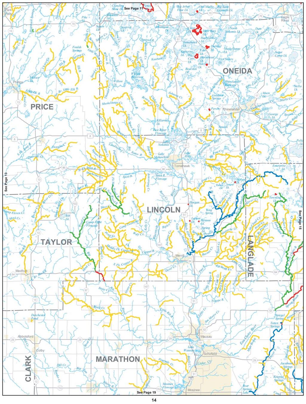
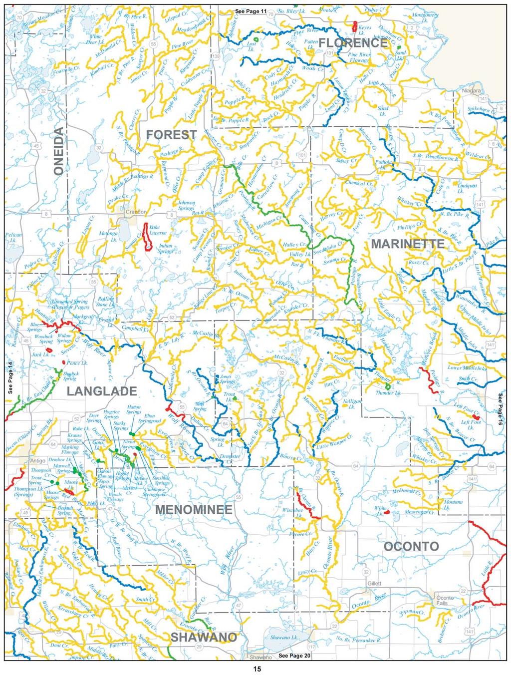
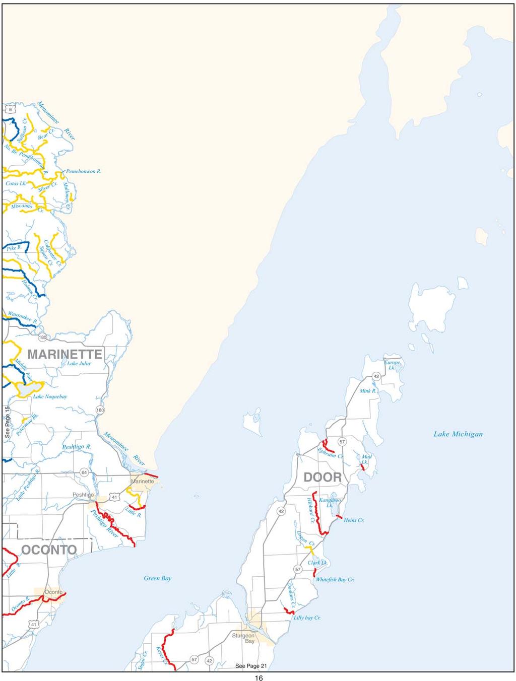
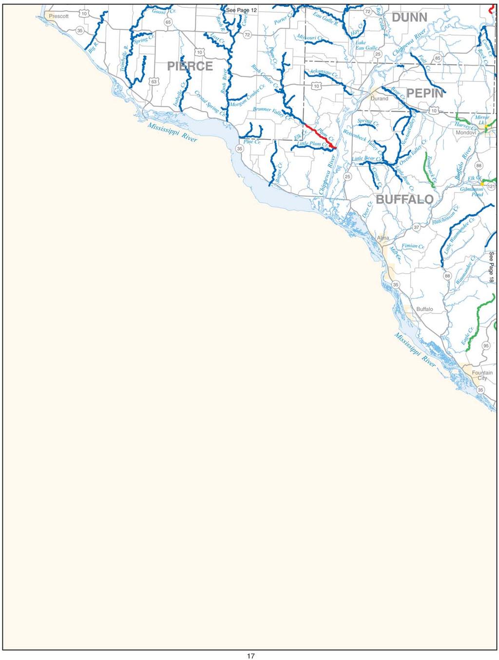
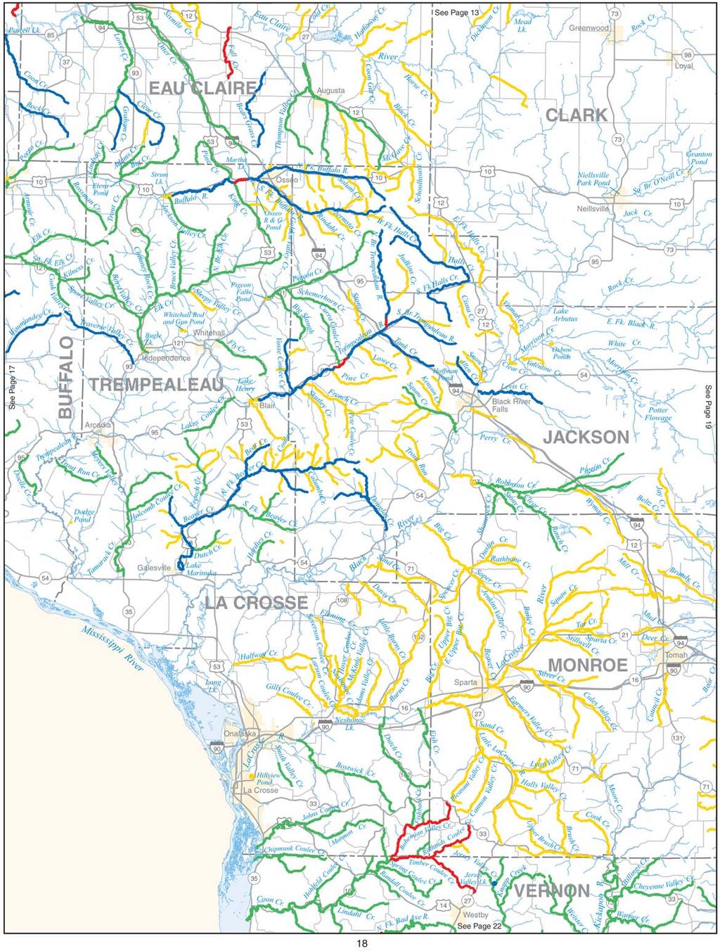
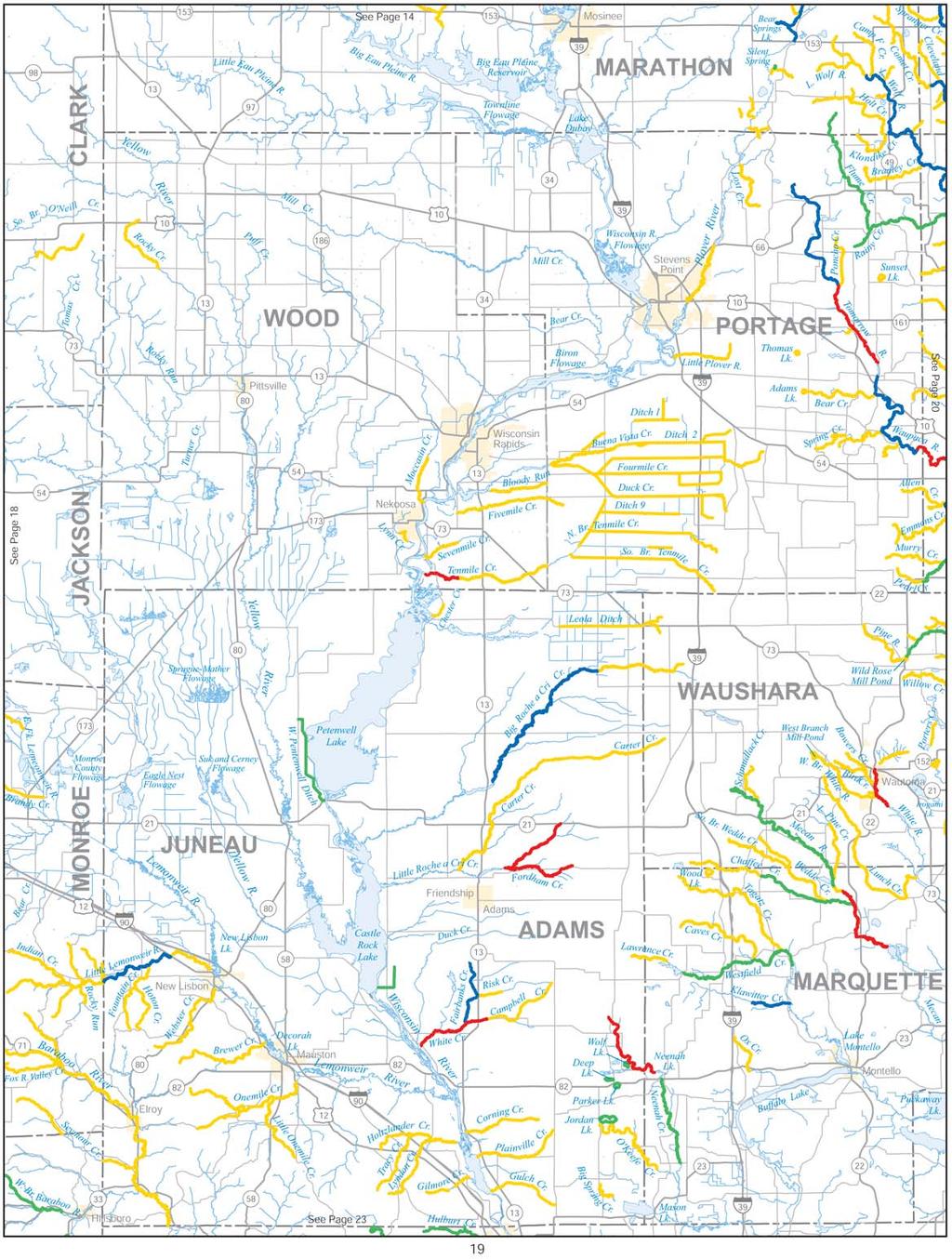
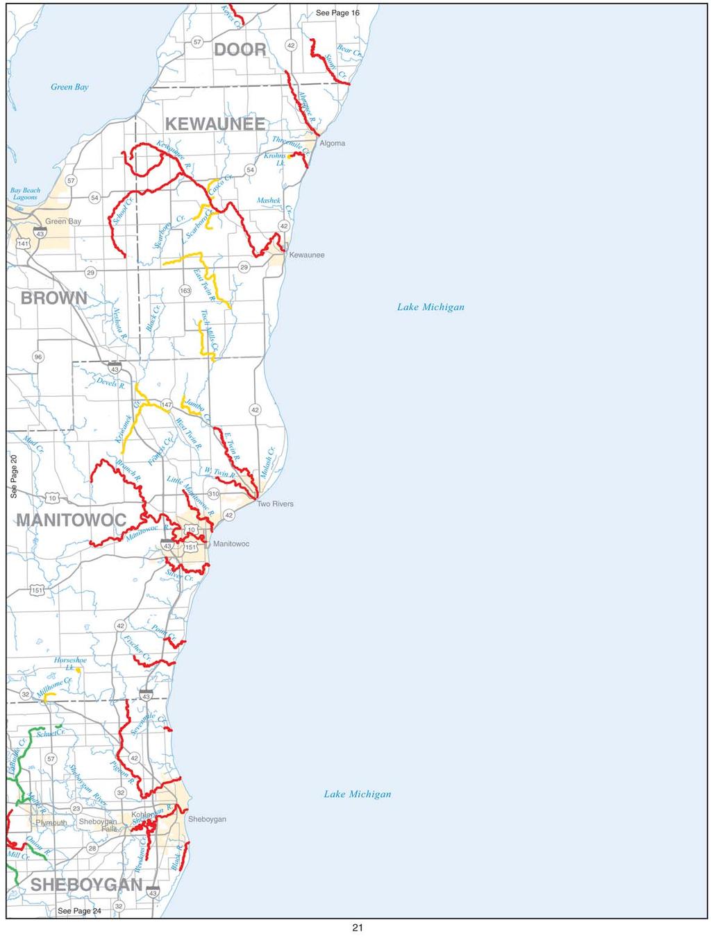
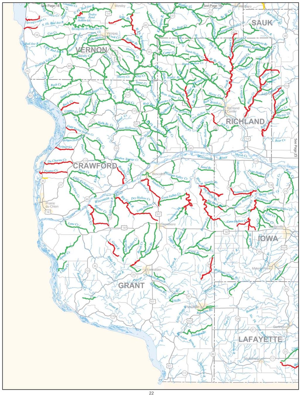
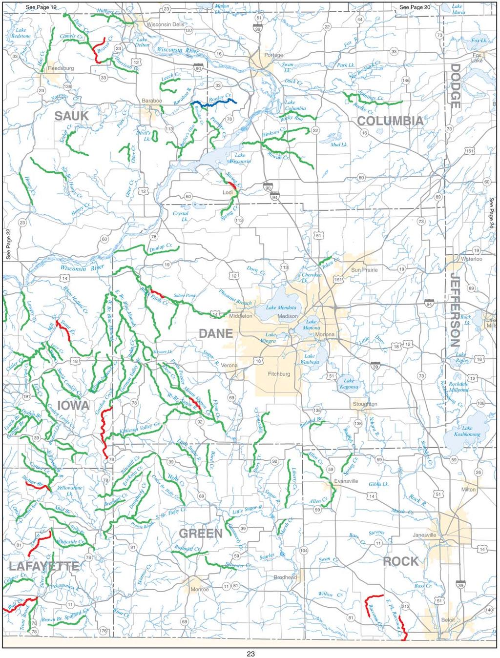
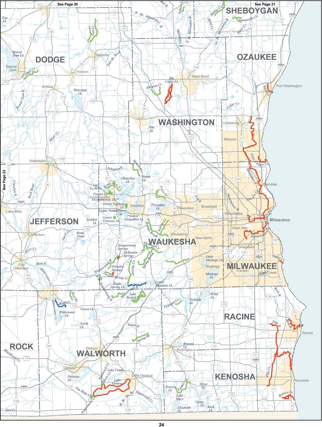
10 TROUT CREEK Downstream of south line of S30, T7N, R5E Category 5 Gear Restriction: None IRON For streams fl owing into Lake Superior that are not listed see the regulations under Lake Superior Streams on page 2. BOOMER CREEK Category 3 FLOOD CREEK Category 3 FOURCHE CREEK Category 3 GRAVEYARD CREEK AND ITS TRIBUTARIES Downstream from USH 2 Category 5 trout over 15", only 1 of which may be a rainbow trout, and none may be brook trout until November 15, Size Limit: brook trout 8" on or after November 15, 2011, brown trout 10", salmon 12", & rainbow trout MONTREAL RIVER Downstream from Superior Falls Category 5 Open Season: all year Daily Bag Limit: 5 trout and salmon Size Limit: 10" MONTREAL RIVER Upstream from Superior Falls along Michigan boundary Category 2 Open Season: April 26 to Sept. 30 ORONTO CREEK AND ITS TRIBUTARIES Category 5 PARKER CREEK Category 5 PLUNKETT (SUGAR) LAKE Category 2 WEBER LAKE Category 2 JACKSON ALLEN CREEK Category 4 BEAVER CREEK (NORTH FORK) Category 4 BIG SLOUGH CREEK Category 3 BUFFALO RIVER (NORTH FORK) Category 4 BUFFALO RIVER (SOUTH FORK) Category 4 CLEAR CREEK (SOUTH BRANCH ROBINSON) Category 3 CURRAN COULEE CREEK Category 3 DOUGLAS CREEK (SHAKE HOLLOW CREEK) Upstream from Douglas Pond Category 4 HALLS CREEK (SOUTH FORK) Category 4 HALLS CREEK (STOCKWELL CREEK) Upstream from GB&W Railroad Crossing (S22,T23N,R4W) Category 4 HALLS CREEK (WEST FORK) Category 4 HOFFMAN POND Category 2 LAKE LEE Category 2 LAKE WAZEE Category 5 Daily bag limit: 2 trout Size limit: 12" LEVIS CREEK Downstream from West Line of S14, T21N, R3 Category 4 OXBOW PONDS Category 2 PIGEON CREEK (MILLSTON) Category 3 PIGEON CREEK (NORTHFIELD) Category 3 8 ROBINSON CREEK Upstream from STH 27 Category 3 SCHERMERHORN CREEK Category 3 SHAKE HOLLOW (NORTH BRANCH)(CREEK 30-15) Category 4 SHAMROCK CREEK Category 3 SQUAW CREEK Category 3 STONY CREEK Category 3 TANK CREEK Category 4 TREMPEALEAU RIVER Davis Road upstream to South Lincoln Road Category 5, only 1 may be a brown trout Size Limit: brown trout 18", brook and rainbow trout 10" TREMPEALEAU RIVER Trempealeau County Line upstream to confluence of West, North, and South branches Category 4 TREMPEALEAU RIVER (NORTH BRANCH) Upstream from Cain Road Category 4 TREMPEALEAU RIVER (NORTH BRANCH) Downstream from Cain Road Category 5, only 1 may be brown trout Size Limit: brown trout 18", brook and rainbow trout 10" TREMPEALEAU RIVER (SOUTH BRANCH) Category 4 VOSSE COULEE CREEK Category 4 WASHINGTON COULEE CREEK Category 4 JEFFERSON All waters not listed Category 3 Index to maps Numbers refer to page numbers The following maps are meant to be a general guide to help you locate trout waters. They do not include unnamed streams or all spring ponds. For exact boundaries of regulations and open seasons see the text of this pamphlet and observe signs posted on the waters. You need a trout stamp and need to obey the base regulations when fi shing for trout in waters not colored on the maps Regulations are continued on page See p. 11
11
12
13
14
15
16
17
18
19
20
21

22
23
24
25
26
27 JUNEAU LEMONWEIR RIVER (LITTLE) Upstream from STH 12 & 16 Category 4 PETENWELL DITCH (WEST) Category 3 KENOSHA ALL WATERS NOT LISTED Category 3 For streams fl owing into Lake Michigan see the regulations under Lake Michigan Streams on p. 2. ALL URBAN WATERS Category 5 Daily Bag Limit: 3 trout Size Limit: none KEWAUNEE For streams fl owing into Lake Michigan see the regulations under Lake Michigan Streams on p. 2. KROHNS LAKE Category 2 LA CROSSE LA CROSSE RIVER AND ALL WATERS NORTH Category 2 ALL WATERS SOUTH OF LA CROSSE RIVER Category 3 BOHEMIAN VALLEY CREEK Category 5 Daily Bag Limit: 5 Size Limit: All trout kept shall be less than 12" HILLVIEW POND Category 2 VETS MEMORIAL PARK POND Category 2 LAFAYETTE ALL WATERS NOT LISTED Category 3 LOVETT S CREEK Category 5 STEINER CREEK Upstream from CTH F Category 5 WOLF CREEK Dunbarton Road upstream to Cub Hollow Road Category 5 WOLF CREEK Junction Trout Brook upstream to Dunbarton Road and upstream from Cub Hollow Road Category 5 LANGLADE BIG HAYMEADOW CREEK Category 3 BLUE SPRINGS Category 5 Size Limit: brown trout 18", brook and rainbow trout 12" CLUBHOUSE SPRING POND Category 3 DEMLOW LAKES (SPRINGS; UPPER & LOWER) Category 3 DREW CREEK Category 3 EAU CLAIRE RIVER (MAIN BRANCH) Including Marathon County downstream to STH 52 Category 3 EAU CLAIRE RIVER (EAST BRANCH) Excluding Blue Bell Road downstream to River Road Category 3 EAU CLAIRE RIVER (EAST BRANCH) Bluebell Road downstream to River Road Category 5 EAU CLAIRE RIVER (WEST BRANCH) Category 3 ELTON SPRING POND Category 3 GARSKI FLOWAGE Category 3 HATTON SPRINGS Category 3 HOGELEE SPRINGS (No.1 & 2) Category 3 HOGLOT SPRINGS Category 3 HUNTING RIVER Downstream from Fitzgerald Dam Road Category 5 Size Limit: brown 18", brook and rainbow trout 12" JACK LAKE Category 5 Daily Bag Limit: 5 Size Limit: None MAXWELL SPRING Category 3 MAYKING CREEK AND FLOWAGE Category 3 MCGEE LAKE Category 5 Closed to trout fi shing in 2008 due to ongoing brook trout restoration project MOOSE LAKE Category 5 Daily Bag Limit: 1 brown trout and 3 brook trout Size Limit: brown trout 18", brook trout 8" MOOSE SPRINGS Category 5 Daily Bag Limit: 1 brown trout and 3 brook trout Size Limit: brown trout 18", brook trout 8" NIXON SPRINGS Category 3 OCONTO RIVER (SOUTH BRANCH) Category 4 PENCE LAKE Category 5 Daily Bag Limit: 5 Size Limit: None PRAIRIE RIVER Category 4 SAUL SPRING Category 3 SPRING BROOK Downstream from CTH X (including Marathon County) Category 5 STARKS SPRINGS Category 3 SUNSHINE SPRINGS Category 3 THOMPSON LAKE (SPRINGS) Category 3 TOWNLINE LAKE (S6, T33N, R10E) Category 5 Daily Bag Limit: 5 Size Limit: None TROUT SPRING Category 3 UNNAMED SPRINGS 2-1(POLAR OR PAGES) (S2, T33N, R11E) Category 5 Size Limit: brown 18", brook and rainbow trout 12" UNNAMED SPRINGS 2-14 (S2, T33N, R11E) Category 5 Size Limit: brown 18", brook and rainbow trout 12" UNNAMED SPRINGS 3-7 (WEIX) (S3, T33N, R11E) Category 5 Size Limit: brown 18", brook and rainbow trout 12" WILLOW SPRINGS Category 5 Size Limit: brown 18", brook and rainbow trout 12" WOLF RIVER except below Category 4 Open season: May 3 at 5:00 a.m. to September 30, the following restrictions apply: Daily Bag Limit: 3 trout Size Limit: brown and rainbow trout 12", brook trout 8" Open season: October 1 to November 15, the following restrictions apply: 25
28 WOLF RIVER Soo Line Railroad Bridge downstream to Dierks Irrigation Hole Category 5 Open season: May 3 at 5:00 a.m. to November 15 WOODUCK SPRINGS Category 5 Size Limit: brown 18", brook and rainbow trout 12" WOODS FLOWAGE Category 3 LINCOLN AMENT LAKE Category 2 Open Season: May 3 at 5:00 a.m. to September 30, Closed in odd-numbered years only. BIG HAYMEADOW CREEK Category 3 BIG RIB RIVER Category 5 HENSON LAKE Category 5 Daily Bag Limit: 5 Size Limit: None HORGAN LAKE Category 5 Daily Bag Limit: 5 Size Limit: None KING SPRING Category 4 LARSON LAKE Category 5 Daily Bag Limit: 5 Size Limit: None MORAINE LAKE Category 5 Daily Bag Limit: 5 Size Limit: None NEW WOOD RIVER Upstream from Whiskey Bill road (S19, T33N, R5E) Category 3 NEW WOOD RIVER (CENTER FORK) Category 3 NEW WOOD RIVER (EAST FORK) Category 3 PAYS SPRINGS (ALTA) (S12, T33N, R7E) Category 4 PRAIRIE RIVER Category 4 PRAIRIE RIVER (NORTH BRANCH) Category 4 SPRING LAKE (SPRINGS; S16, T32N, R7E) Category 4 TAHOE LAKE Category 2 Open Season: Closed in Open in even-numbered years. MANITOWOC ALL WATERS Category 2 For stream fl owing into Lake Michigan see the regulations under Lake Michigan Streams on page 2. HORSESHOE LAKE Category 2 MARATHON BEAR SPRINGS Category 4 CLARK SPRINGS Category 4 EMBARRASS RIVER (SOUTH BRANCH) Downstream from Norrie Road Category 4 EAU CLAIRE RIVER (MAIN BRANCH) Upstream of STH 52 Category 3 FLUME CREEK Category 3 JACOBSON SPRINGS Category 3 LITTLE WOLF RIVER Upstream to River Drive Category 4 PLOVER RIVER STH 153 upstream to CTH Z Category 4 PLOVER RIVER CTH Z upstream to outlet of Totten Springs Category 5 Daily Bag Limit: 3 trout in total Size Limit: all trout kept shall be between 10" and 13" SILENT SPRINGS Category 3 SPIEGEL SPRINGS Category 4 26 SPRING BROOK Category 5 TOTTEN SPRINGS Category 4 MARINETTE For streams fl owing into Green Bay see the regulations under Lake Michigan Streams on page 2. BEAVER CREEK (INCLUDING NORTH AND SOUTH BRANCHES) Category 4 HOLMES CREEK Category 4 K.C. CREEK Category 4 LEFT FOOT LAKE Category 5 LINDQUIST LAKE Category 2 MIDDLE INLET CREEK Category 4 MONTANA LAKE Category 2 MURPHY LAKE Category 2 NOQUEBAY LAKE Category 2 PESHTIGO RIVER Upstream from CTH C Category 3 Open season: May 3 at 5:00 a.m. to September 30, the following restrictions apply: Daily Bag Limit: 3 trout Size Limit: 9" Open season: October 1 to November 15, the following restrictions apply: PESHTIGO RIVER Between Johnson Falls and Spring Rapids Category 5 Size Limit: brown trout 18", brook and rainbow trout 12" PIKE RIVER Category 4 PIKE RIVER (NORTH BRANCH) Mouth upstream to KC Creek Category 4 POTHOLE LAKE Category 2 RAT RIVER Category 2 SAND LAKE Category 2 SMITH CREEK Category 4 SPIKEHORN CREEK Category 4 THUNDER LAKE Category 3 THUNDER RIVER (NORTH FORK) Category 4 THUNDER RIVER (SOUTH FORK) Category 4 WAUSAUKEE RIVER Category 4 MARQUETTE CHAFFEE CREEK CTH B downstream to Mecan River Category 3 KLAWITTER CREEK Category 4 MECAN RIVER Upstream from 14th Ave Category 3 MECAN RIVER 14th Avenue downstream to Germania marsh barrier Category 5 Daily Bag and Size Limit: 3 trout, only 1 of which is over 15" Size Limit: all trout 12"
29 NEENAH CREEK (UPPER) Upstream from STH 82 Category 5 Gear Restrictions: Only artifi cial lures may be used Size Limit: 14" NEENAH CREEK (LOWER) Downstream from STH 82 Category 3 WESTFIELD CREEK Downstream from Lawrence Lake Category 3 WOOD LAKE Category 2 MENOMINEE ALL WATERS Category 2 Menominee County is an Native American reservation. Find out about tribal policies at tribal headquarters. State laws apply to non-native Americans fi shing on the Menominee Reservation. MILWAUKEE ALL WATERS NOT LISTED Category 3 For streams fl owing into Lake Michigan see the regulations under Lake Michigan Streams on p. 2. ALL URBAN WATERS Category 5 Daily Bag Limit: 3 trout Size Limit: none MONROE BOHEMIAN VALLEY CREEK Category 5 Size Limit: all trout kept shall be less than 12" CLEAR CREEK Category 3 RANCH CREEK Category 3 RULLANDS COULEE CREEK Category 5 Size Limit: all trout kept shall be less than 12" OCONTO For streams fl owing into Green Bay see the regulations under Lake Michigan Streams on page 2 FORBES SPRINGS Category 4 GRIGNON LAKE Category 2 JONES SPRINGS Category 4 MARY LAKE Category 3 NELLIGAN LAKE Category 2 OCONTO RIVER (1ST SOUTH BRANCH) STH 64 downstream to mouth Category 4 OCONTO RIVER (SOUTH BRANCH) CTH AA downstream to STH 32 Category 5 Size Limit: brook trout and rainbow trout 12", brown trout 18" OCONTO RIVER (SOUTH BRANCH) Upstream from Menominee County Category 4 SULLIVAN SPRINGS Category 4 THUNDER RIVER (NORTH FORK) Category 4 THUNDER RIVER (SOUTH FORK) Category 4 TOWN SPRINGS and CREEK Category 4 TROUT LAKE Category 3 WAUPEE CREEK Category 4 WHITE LAKE Category 5 WISCOBEE LAKE Category 2 27 ONEIDA BIG CARR LAKE Category 5 Daily Bag Limit: 1 trout Size Limit: 30" CLEAR LAKE (S16, T39N, R7E) Category 5 Daily Bag Limit: 1 trout Size Limit: 30" DOROTHY LAKE Category 5 Daily Bag Limit: 5 trout HAWK LAKE Category 5 Daily Bag Limit: 5 Size Limit: none LITTLE BASS LAKE (S15, T39N, R7E) Category 5 Open Season: May 3 at 5:00 a.m. to November 15 Daily Bag Limit: 5 trout PERCH LAKE (S2, T36N, R7E) Category 5 Daily Bag Limit: 5 trout OUTAGAMIE ALL WATERS Category 2 OZAUKEE ALL WATERS NOT LISTED Category 3 For streams flowing into Lake Michigan see the regulations under Lake Michigan Streams on p. 2. ALL URBAN WATERS Category 5 Daily Bag Limit: 3 trout Size Limit: none PEPIN ALL WATERS NOT LISTED Category 4 PIERCE ALL WATERS NOT LISTED Category 4 KINNICKINNIC RIVER Downstream from lower pond in River Falls and Rocky branch Category 5 Daily Bag Limit: 5 trout under 10", or 4 trout under 10" and 1 over 14" KINNICKINNIC RIVER Downstream from St. Croix County line including both fl owages in River Falls downstream to the lower pond dam Category 2 POLK APPLE RIVER Downstream from Black Brook Dam Category 4 CLAREY LAKE Category 2 CRESCENT LAKE Category 2 ICE HOUSE LAKE Category 2 LOWER PINE LAKE Category 2 ORE CREEK Category 5 Size Limit: all trout kept shall be less than 12" SAND CREEK Category 5 Size Limit: all trout kept shall be less than 12" SPENCER CREEK Category 5 Size Limit: all trout kept shall be less than 12"
30 PORTAGE ADAMS LAKE Category 2 FLUME CREEK Category 3 LITTLE WOLF RIVER Category 4 RAINY CREEK Category 3 SPRING LAKE Category 2 SUNSET LAKE Category 2 THOMAS LAKE Category 2 TOMORROW (WAUPACA) RIVER Durant Rd. downstream to River Road in Waupaca County Category 5 Size Limit: brown trout 18", brook trout and rainbow trout 12" TOMORROW (WAUPACA) RIVER (LOWER) Durant Rd. upstream to Amherst dam Category 4 TOMORROW (WAUPACA) RIVER Old Railroad Bridge north of Amherst upstream to Poncho Creek Category 5 Daily Bag Limit: 3 trout in total, only 1 over 20" Size Limit: 3 trout may be kept between 10" and 13", or 2 trout between 10" and 13" and 1 over 20" TOMORROW (WAUPACA) RIVER (UPPER) Upstream from Poncho Creek Category 4 PRICE BUTTERNUT CREEK AND TRIBUTARIES Category 2 DAVE LAKE Category 2 FOULDS SPRINGS Category 3 HOGSBACK (SPUR LAKE) SPRINGS Category 3 PATTERSON LAKE Category 2 PRICE CREEK Downstream from Lower Price lake Category 3 TWIN LAKE Category 2 RACINE ALL WATERS NOT LISTED Category 3 For streams fl owing into Lake Michigan see the regulations under Lake Michigan Streams on p. 2. ALL URBAN WATERS Category 5 Daily Bag Limit: 3 trout Size Limit: none RICHLAND ALL WATERS NOT LISTED Category 3 ASH CREEK Upstream from STH 80 Category 5 BEAR CREEK Upstream from STH 130 bridge in S14, T9N, R2E Category 5 Daily Bag Limit: 2 trout GAULT HOLLOW CREEK Downstream from CTH H Category 5 LITTLE WILLOW CREEK Downstream from Spiral Road Category 5 Daily Bag Limit: 2 trout MELANCHTON CREEK Upstream of STH 80 at north line of NE 1 /4, SE 1 /4, S22, T12N, R1E Category 5, only 3 may be brook trout Size Limit: 7" brown and rainbow trout, brook trout must be between 6" 9" MELANCHTON CREEK Downstream of STH 80 at north line of NE 1 /4, SE 1 /4, S22, T12N, R1E Category 5, only 3 may be brook trout Size Limit: 7" brown and rainbow trout, brook trout must be between 6" 9" MILL CREEK USH 14 upstream to Quarry Hill Road Category 5 PINE RIVER Uppermost STH 80 bridge downstream to CTH AA Category 5 Daily Bag Limit: 2 trout PINE RIVER (WEST BRANCH) Old County Farm Drive upstream to Spangler Ridge Road Category 5 SMITH HOLLOW CREEK Downstream from Smyth Hollow Road Category 5 WILLOW CREEK STH 58 bridge 2.75 miles south of Ithaca upstream to Lost Hollow Road, and STH 58 bridge 0.25 mile north of Loyd upstream to county line Category 5 Daily Bag Limit: 2 trout WILLOW CREEK Lost Hollow Road upstream to STH 58 bridge 0.25 mile north of Loyd Category 5 ROCK ALL WATERS NOT LISTED Category 3 All Rock County lakes and ponds have an open season from January 1 to September 30 RACCOON CREEK AND RACOON CREEK (EAST BRANCH) Category 5 RUSK ALL STREAMS NOT LISTED Category 2 ALL LAKES AND SPRING PONDS NOT LISTED Category 3 BASS L (WEYERHAUSER) Category 5 Daily Bag Limit: 1 trout Size Limit: 15" BIG WEIGOR CREEK Category 3 CORBETT LAKE Category 2 DEER CREEK Category 3 DEVILS CREEK Category 3 DEVILS CREEK TROUT POND Category 2 HAWKINS MILL POND Category 2 HEMLOCK CREEK Category 3 LITTLE WEIGOR CREEK Category 3 MAIN CREEK (SOUTH FORK) Category 3 SOFT MAPLE CREEK Category 3 THREE LAKES NUMBER ONE Category 3 28
31 SAUK ALL WATERS NOT LISTED Category 3 BEAR CREEK County line upstream to CTH N and upstream from Croal Hollow Road Category 5 BEAR CREEK CTH N upstream to Croal Hollow Road Category 5 Gear Restriction: None BEAVER CREEK Category 5 DELL CREEK Coon Bluff Road upstream to South Avenue Category 5 DEVIL S LAKE Category 3 ROWLEY CREEK Category 4 WILLOW CREEK Upstream from county line Category 5 SAWYER ALL STREAMS NOT LISTED Category 2 ALL LAKES AND SPRING PONDS NOT LISTED Category 3 ASHEGON LAKE Category 3 BLACK DAN LAKE Category 5 Daily Bag Limit: 1 trout Size Limit: 15" BRUNET RIVER Category 3 CAMP SMITH LAKE Category 3 COUDERAY RIVER Category 3 DEER CREEK (METEOR TOWNSHIP) Category 3 EDDY CREEK Category 3 FIDDLER CREEK Category 5 HAUER SPRINGS Category 5 Size Limit: 15" LITTLE WEIGOR CREEK Category 3 MCDERMOTT BROOK Category 3 NAMEKAGON RIVER STH 63 upstream to Pacawong Dam Category 5 Size Limit: 15" NAMEKAGON RIVER Hospital Road upstream to Phipps Dam Category 5 NAMEKAGON RIVER Downstream from Lake Hayward Category 5 Open Season: May 3 at 5:00 a.m. to September 30 Daily Bag Limit: 3 trout Size Limit: 9" Open Season: October 1 to May 3, the following restrictions apply: OSGOOD LAKE Category 5 Size Limit: 15" PERCH LAKE Category 3 29 PORCUPINE LAKE Category 5 Size Limit: 15" PRICE CREEK Category 3 ROUND LAKE Category 5 Daily Bag Limit: 1 trout Size Limit: 18" SILVERTHORNE LAKE Category 5 Daily Bag Limit: 1 trout Size Limit: 15" STRESS SPRINGS Category 5 THORNAPPLE RIVER Category 3 TOTAGATIC RIVER Category 3 VENISON CREEK Category 3 SHAWANO BAHR LAKE See Koth and Bahr Lakes COMET CREEK Downstream from CTH P Category 4 EMBARRASS RIVER (MIDDLE BRANCH) CTH Z downstream to Homme Pond Dam Category 4 EMBARRASS RIVER (SOUTH BRANCH) Upstream from Tigerton dam Category 4 EMBARRASS SPRINGS Category 4 HOMME POND Category 4 KOTH AND BAHR LAKES Category 2 MILL CREEK Downstream from STH 29 Category 3 RED RIVER CTH A at village of Red River upstream to Lower Red Lake dam Category 3 RED RIVER (WEST BRANCH) Downstream from CTH D Category 4 SHIOC RIVER (WEST BRANCH) Upstream from Sunrise Road Category 4 SHEBOYGAN ALL WATERS NOT LISTED Category 3 For streams flowing into Lake Michigan see the regulations under Lake Michigan Streams on p. 2. ALL URBAN WATERS Category 5 Daily Bag Limit: 3 trout Size limit: none BEN NUTT CREEK Category 5 Size Limit: 15" MILL CREEK Category 5 Size Limit: 15" ONION RIVER Upstream from CTH E Category 5 Size Limit: 15" ST. CROIX ALL WATERS NOT LISTED Category 4 APPLE RIVER Category 2 GLEN LAKE Category 3 KINNICKINNIC RIVER Category 2 PARKER CREEK Category 2 PERCH LAKE Category 3 WILLOW RIVER From Willow Falls in Willow River state park upstream to the confl uence on the north and south forks Category 2 WILLOW RIVER (NORTH FORK) Category 2
32 TAYLOR BIG RIB RIVER CTH C downstream to STH 64 Category 3 BIG RIB RIVER Downstream from STH 64 Category 5 CAMP 8 FLOWAGE Category 2 SPRUCE LAKE Category 2 WOOD CREEK Category 3 TREMPEALEAU ABRAHAM COULEE CREEK Category 4 ADAMS CREEK Category 3 ARCTIC SPRINGS GOLF COURSE POND Category 2 BEAR CREEK Category 4 BEAVER CREEK Category 4 BEAVER CREEK (NORTH FORK) Category 4 BEAVER CREEK (SOUTH FORK) Category 3 ROSSMAN CREEK Category 3 BIG CREEK Category 3 BORST VALLEY CREEK Category 3 BRUCE VALLEY CREEK Category 3 BUFFALO RIVER CTH OOO downstream to Tracey Valley Road (S8, T24N, R7W) Category 5 Daily Bag Limit: 2 trout, only 1 may be a brown trout Size Limit: brown trout 18", brook and rainbow trout 10" BUFFALO RIVER Osseo to Strum except above Category 4 BUFFALO RIVER (NORTH FORK) Category 4 BUFFALO RIVER (SOUTH FORK) Category 4 BUGLE LAKE Category 2 CHIMNEY ROCK CREEK Category 3 DODGE POND Category 2 DUTCH CREEK Category 3 ELEVA POND Category 2 ELK CREEK Category 3 ELK CREEK (NORTH BRANCH) Category 3 ELK CREEK (BENNET) Category 3 FLY CREEK Category 3 FRENCH CREEK Category 3 HARDIES CREEK Category 3 HOLCOMB COULEE CREEK Category 3 JOHNSON VALLEY CREEK Category 3 KILNESS CREEK Category 3 KING CREEK Category 3 LAKE HENRY Category 2 LAKE MARTHA Category 2 LAKES COULEE CREEK Category 3 LINDSAY CREEK Category 3 MEYER VALLEY CREEK Category 3 OSSEO ROD AND GUN POND Category 2 PIGEON CREEK Upstream from Pigeon Falls Pond Category 3 PIGEON FALLS POND Category 2 PINE CREEK Category 3 ROSSMAN CREEK Category 3 SALZWEDEL COULEE CREEK Category 3 SCHERMERHORN CREEK Category 3 SPORT VALLEY CREEK Category 3 STRUM LAKE Category 2 TAMARACK CREEK Category 3 TRAVERSE VALLEY CREEK Category 4 TREMPEALEAU RIVER Category 4 TROUT CREEK Category 3 TROUT RUN CREEK Category 3 VOSSE COULEE CREEK Category 4 WASHINGTON COULEE CREEK Category 4 WHITEHALL ROD AND GUN POND Category 2 VERNON ALL WATERS NOT LISTED Category 3 BISHOP BRANCH Category 5 Size Limit: all trout kept must be less than 12" ESOFEA BRANCH From Rung Hollow Lake upstream to Saxford Road Category 5 KICKAPOO RIVER (WEST FORK) STH 82 upstream to CTH S and Bloomingdale road (S6, T13N, R3W) Category 5 MELANCTHON CREEK Category 5, only 3 may be brook trout Size Limit: 7" brown and rainbow trout, brook trout must be between 6" 9" SEAS BRANCH CREEK Upstream from junction of stream and impoundment in S14, T13N, R4W Category 5 TIMBER COULEE CREEK CTH P upstream to Olstad Road Category 5 TIMBER COULEE CREEK Other than above Category 5 Size Limit: all trout kept must be less than 12" UNNAMED CREEK 16-6 (S16, T13N, R7W) Category 5 UNNAMED CREEK 29-4 (S29, T13N, R7W) Category 5 VILAS BLACK OAK LAKE Category 5 Size Limit: 30" BLUEGILL LAKE Category 5 Size Limit: none CRYSTAL LAKE (S27, T41N, R7E) Category 5 Size Limit: DEERSKIN RIVER Blackjack Creek downstream to Range Line Road Category 5 Daily Bag and Size Limit: 2 brook trout over 12", & 1 brown trout over 18" DOROTHY LAKE Category 5 Size Limit: none 30
33 FALLISON LAKE Category 5 Open Season: May 3 at 5:00 a.m. to November 15 Daily Bag Limit: 5 trout Size Limit: 7" FENCE LAKE Category 5, only 3 of which can be brown trout Size Limit: brook trout 7", brown trout 20" FIRE FLY LAKE Category 5 Size Limit: none LAC DU LUNE LAKE Category 5 Daily Bag Limit: 5 trout LITTLE JOHN JR. LAKE Category 5 Size Limit: none LITTLE TROUT LAKE Category 5 Size Limit: LONG LAKE Category 5 Size Limit: 30" OTTO MIELKE LAKE Category 5 Size Limit: none PALLETTE LAKE Category 5 Season closed all year. No fi shing for lake trout. PAUTO LAKE Category 5 Size Limit: none SHANNON LAKE Category 5 Daily Bag Limit: 5 trout SPECTACLE LAKE All Category 5 Daily Bag Limit: 5 trout STORMY LAKE Category 5 Daily Bag Limit: 5 trout TROUT LAKE Category 5 Open Season for lake trout: May 3 at 5:00 a.m. to September 30 Size Limit: 30" WILDWOOD LAKE Category 5 Open Season: May 3 at 5:00 a.m. to November 15 Daily Bag Limit: 5 trout WALWORTH ALL WATERS NOT LISTED Category 3 ALL URBAN WATERS Category 5 Daily Bag Limit: 3 trout Size limit: none BEULAH LAKE Category 3 BLUFF CREEK Category 4 LAKE GENEVA Category 5 Open Season for lake trout: January 5 to September 30, 2008 (January 3 to September 30, 2009) Open Season for other trout: May 3 at 5:00 a.m. to March 1, 2009 Daily Bag and Size Limit: 2 lake trout over 17", & 3 other trout over 9" WHITEWATER CREEK Upstream of Willis Ray Road Category 4 WASHBURN ALL LANDLOCKED LAKES AND PONDS WITHOUT OUTLET STREAMS, NOT OTHERWISE LISTED Category 2 ALL STREAMS, SPRING PONDS, AND LAKES WITH OUTLET STREAMS, NOT OTHERWISE LISTED Category 2 Open Season: May 3 at 5:00 a.m. to September 30 BRILL RIVER Category 4 SAWMILL LAKE Category 5 TOZER LAKE Category 5 WASHINGTON ALL WATERS NOT LISTED Category 3 ALL URBAN WATERS Category 5 Daily Bag Limit: 3 trout Size Limit: none BIG CEDAR LAKE Category 5 Open Season for lake trout: January 5 to September 30, 2008 (January 3 to September 30, 2009) Daily Bag Limit: 2 lake trout Size Limit: lake trout 17" WAUKESHA ALL WATERS NOT LISTED Category 3 ALL URBAN WATERS Category 5 Daily Bag Limit: 3 trout Size Limit: none FOWLER LAKE Category 3 LOWER GENESEE LAKE Category 3 LOWER NASHOTAH LAKE Category 3 MCKEAWN SPRINGS Category 5 Open Season: January 1 to September 30 MUKWONAGO RIVER Eagle Spring Lake downstream to Lower Phantom Lake Category 4 PARADISE SPRINGS CREEK Upstream from CTH N Category 5 Open Season: January 1 to September 30 SCUPPERNONG SPRINGS Category 5 Open Season: January 1 to September 30 WAUPACA BASS LAKE Category 2 CHAIN OF LAKES (ALL LAKES) Category 4 COMET CREEK Category 4 CRYSTAL RIVER Category 3 FLUME CREEK Category 3 LITTLE LONG LAKE Category 2 31
 Category 3 MIRROR LAKE Category 2 RADLEY CREEK Category 3 WALLA WALLA CREEK Category 3 WAUPACA (TOMORROW) RIVER River Road upstream to Durant Road in Portage County Category")
34 LITTLE WOLF RIVER CTH J upstream to Ness Road Category 5 Daily Bag Limit: 1 trout Size Limit: brook trout 14" LITTLE WOLF RIVER All except portion described above and south branch Category 4 LITTLE WOLF RIVER (SOUTH BRANCH) Category 3 MIRROR LAKE Category 2 RADLEY CREEK Category 3 WALLA WALLA CREEK Category 3 WAUPACA (TOMORROW) RIVER River Road upstream to Durant Road in Portage County Category 5 Daily Bag Limit: 1 trout Size Limit: brook trout and rainbow trout 12", brown trout 18" WAUPACA (TOMORROW) RIVER All except portion listed above Category 4 WAUSHARA JOHNS LAKE Category 2 GILBERT LAKE Category 2 MECAN RIVER AND SPRINGS Category 3 PEARL LAKE Category 2 PINE LAKE Category 2 PINE RIVER (LOWER) Downstream from Wild Rose millpond Category 3 PINE RIVER (UPPER) Upstream from Wild Rose millpond Category 2 SPRING LAKE Category 2 WHITE RIVER POND (WEST BRANCH) Category 2 WHITE RIVER (MAIN BRANCH) Upstream from Lower White River millpond Category 5 Daily Bag and Size Limit: 3 trout per day, only 1 brown trout over 15" WHITE RIVER Category 3 WHITE RIVER (WEST BRANCH) Category 2 Open Season: May 3 at 5:00 a.m. to Sept. 30 WILD ROSE MILL POND Category 2 WILLOW CREEK Downstream from Blackhawk Road Category 3 WINNEBAGO ALL WATERS Category 2 WOOD TEN MILE CREEK Upstream for Rangeline Road Category 2 TEN MILE CREEK Downstream from Rangeline Road Category 5 Daily Bag Limit: 1 trout Size Limit: 15" Public or Private? How Do I Know If I m Trespassing? Navigability determines whether a waterway is public or private. Navigable lakes and streams are public waterways. A waterway is navigable if it has a bed and banks and it is possible to fl oat a canoe or other small craft at sometime of the year even if only during spring fl oods. Because they are public, you may use navigable waters for fi shing, boating, swimming or other recreational activities, provided public access is available, or you have permission of the land owner to cross their property to reach the waterway. Once on a navigable waterway, AS LONG AS YOU KEEP YOUR FEET WET, YOU MAY WALK ALONG THE BED OF THE STREAM, FISH, SWIM, OR BOAT IN ANY NAVIGABLE LAKE OR STREAM. TV Show for Kids Into the Outdoors is DNR s Emmy Award winning TV show for kids. The half-hour program is hosted by kids who use the Internet to fi nd other kids their age doing outdoor activities and learning about the environment. The show is linked to EEK!, DNR s web site for kids, and airs on weekend mornings. See local TV listings for times and stations. Report Hunting and Fishing Violations Call TIP-WDNR ( ) Toll Free Statewide 24 hour Confidential General information call: toll free WDNRINFO ( ) or or local DNR offi ce The Wisconsin Department of Natural Resources provides equal opportunity in its employment, programs, services and functions under an Affi rmative Action Plan. If you have any questions, please write to Equal Opportunity Offi ce, Department of the Interior, Washington, D.C This publication is available in alternate format upon request. Please call (608) for additional information. Printed on Recycled Paper JG12/07 32
35 Wisconsin Trout Stream Habitat Management What s At Stake? Wisconsin has over 2,900 trout streams, the majority exhibiting some degree of natural reproduction. Their protection and improvement are cornerstones of DNR s trout management program. While all the streams require protection, about 30 percent need some form of habitat improvement. Both the resource and the quality of trout fi shing are at stake. Why Manage Trout Stream Habitat? Habitat management focuses on the stream channel and its banks. The idea is to create conditions favorable for trout by adding something to the stream or modifying what s already present. Trout need certain environmental conditions, called habitat, to survive and fl ourish. Cold water, plenty of oxygen, sheltered places to hide and rest, and abundant supplies of insects and forage fi sh are the most important. For streams supporting wild trout, add gravel beds for spawning, water swift enough to sweep silt from developing eggs, and half a dozen other factors just beginning to be understood. Leave out one of these conditions and you may still have a trout stream, but it probably won t produce to capacity. Leave out many more and you can forget about the trout. They won t be there. Trout streams have been shaped by the forces of nature. No amount of management can make one out of a stream that wasn t meant for it. But management can restore damaged streams. Beaver dams, cattle grazing, highway construction, pollution and fl oods all take their toll on trout habitat. You can measure the damage in higher water temperatures, caved-in stream banks, turbid water, or number of trout lost. Habitat management can also make good streams better by increasing the number and size of trout. Some streams have all the required conditions but not in large enough doses. Here, management steps in to fi nd out what s limiting trout production and takes up the slack. More and better fi shing opportunities are the fi nal goal. The Trout Stamp Money was always a problem in the habitat management program. There was never enough to go around. When Wisconsin s trout stamp came along, the situation made a quick turn for the better. Although talked about for over 30 years, it did not become offi cial until That year, the State Legislature approved the special stamp, with all proceeds going to improve and maintain habitat on inland trout streams. A limitation is that work must pertain to the stream channel and its immediate surroundings. Habitat protection away from the stream is not included. Management Beyond The Stream Streams are where the trout are and where the fi shing is, too. But good management requires looking beyond the stream, often miles away, to the land that surrounds it, the watershed. What goes on there can have a profound effect on the stream and its trout population. Pollution is a major concern, and much of it is a kind that can t be traced to any specifi c source. This is called non-point pollution. Agricultural chemicals, manure, silt and oil residues are examples, entering streams as runoff from farm fi elds, feed lots and highways. Trout can be affected directly through their body metabolism or indirectly, through deterioration of their habitat. Flooding is also a problem, especially in hilly southwest and west central Wisconsin. Being the low point in a watershed, streams receive all rain that isn t trapped on the land. Land denuded of natural vegetation or improperly farmed will send this water gushing to the stream, often with disastrous results. Too little water poses problems of a different sort. The springs, feeder streams, runoff and groundwater that supply trout streams are critical to their health. Both quantity and temperature of the water are important. Dams that cut off water or heat it up can mean big trouble. So can irrigation. Although not funded by the trout stamp, watershed management is a high priority within the DNR. It takes several forms. DNR s permit system protects trout streams and their feeders from dams and excessive irrigation. Whenever possible, spring holes are purchased. Non-point pollution and fl ooding are being addressed through education and cooperation with landowners, with funding provided by the priority watershed program. Illustration by Jim McEvoy Is Your Favorite Stream In Jeopardy? Any physical altering of a stream requires specifi c permits and should be carefully supervised. Dredging Dam building Filling Pond building Irrigating Channelizing Straightening These are all carefully controlled activities. If you see any suspicious activities going on in streams, please notify your local DNR offi ce. If you are a land owner, please acquire the proper information prior to altering any streams.


 from the salmon.")

36 Inland Trout Identifying Trout and Salmon Great Lakes Trout Brook Trout Reddish spots with blue halos Irregular wormlike markings on back and dorsal fi n Square tail Pale markings may look similar to small lake trout Square tail Pinkish fi ns edged in white Brown Trout Large black, blue or red spots on body Square tail with few spots Very silvery in summer. Dark spots on body but not colorful reds or blue anal rays Rainbow Trout Many small spots on body Square tail with many spots over entire tail in radiating rows Spots all over tail remain, but rest of body is silver. White mouth and gums anal rays White mouth identifi es rainbow (steelhead) from the salmon. Great Lakes Salmon and Lake Trout Chinook Salmon Spots over Coho Salmon Spots on upper entire tail part of tail Black mouth and gums anal rays Black mouth and white gums anal rays Lake Trout Irregular wormlike markings on back and dorsal fi n Light spots in body and tail Deeply forked tail Illustrations by Virgil Beck
Labor Hours per Lane Mile per Severity Index (to date, as of 4/14/16) From Winter Storm Reports,
 From Winter Storm Reports,") Region NC ADAMS $239,584 $341,851 $229,513 $355,706 $445,843 $251,132 $427,062 78.89 107.49 94.17 129.06106.65 84.17 123.39 4.63 6.83 4.79 8.02 7.64 4.49 9.23 0.06 0.06 0.05 0.06 0.07 0.05 0.07 FLORENCE
Region NC ADAMS $239,584 $341,851 $229,513 $355,706 $445,843 $251,132 $427,062 78.89 107.49 94.17 129.06106.65 84.17 123.39 4.63 6.83 4.79 8.02 7.64 4.49 9.23 0.06 0.06 0.05 0.06 0.07 0.05 0.07 FLORENCE
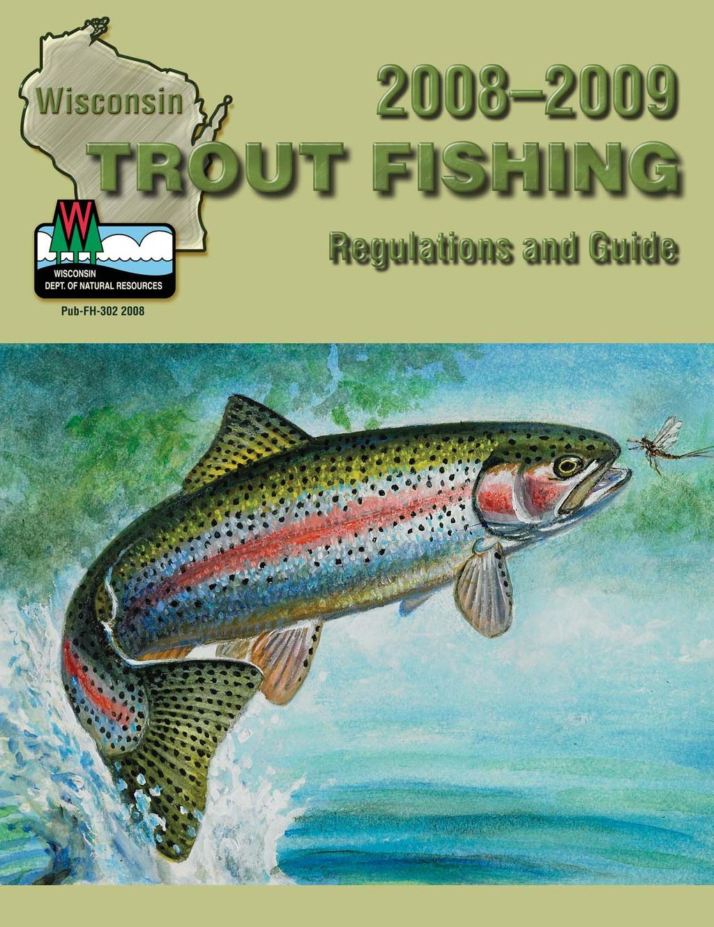
Wisconsin TROUT FISHING. Regulations and Guide
 2005-2006 2005-2006 Wisconsin TROUT FISHING Regulations and Guide PUB-FH-302 2005 Dear Trout Angler, As you plan your trout fishing trip in Wisconsin for 2005, it s a fair question to ask what you get
Beaver Trapping Questionnaire By Brian Dhuey and John Olson
 Beaver Trapping Questionnaire 2009-2010 By Brian Dhuey and John Olson Abstract An estimated 2,344 people trapped for beaver during the 2009-10 beaver trapping season. They harvested an estimated 31,049
Beaver Trapping Questionnaire By Brian Dhuey and John Olson
 Beaver Trapping Questionnaire 2012-2013 By Brian Dhuey and John Olson Abstract Beaver trappers, days afield, sets made and mean beaver trapped during the 2012-13 season were all down from 2011-12 levels.
Wisconsin TB Program Update
 Wisconsin TB Program Update Pa Vang, RN, MSN Philip Wegner, RN, MPH Wisconsin TB Program WMLN Conference November 2015 1 Disclosure None 2 Objectives To describe US TB epidemiology To describe Wisconsin
Administrative Note: The collection was reprocessed by Kevin Abing, February The finding aid was retyped on August 8, 2011 by Jenny Stevenson.
 Title: Farmer-Labor-Progressive Federation Collection Call Number: Mss-0813 Inclusive Dates: 1936 1940 Bulk: 4.6 cu. ft. Location: ER, Sh. 213-214 OS SM F (1 item) Abstract: In November 1935, a coalition
Frog and Toad Survey, 2000 By Brian Dhuey, and Bob Hay
 Frog and Toad Survey, By Brian Dhuey, and Bob Hay Abstract The number of frog survey routes decreased to 77 in from 95 in 999. The number of sites with Chorus Frog, Copes Gray Tree Frog, Leopard Frog,
WISCONSIN DEPARTMENT OF NATURAL RESOURCES
 WISCONSIN DEPARTMENT OF NATURAL RESOURCES RESEARCH REPORT187 April 2004 A Compendium of 58 Trout Stream Habitat Development Evaluations in Wisconsin 1985-2000 1 by Ed L. Avery Bureau of Integrated Science
What is a Spring Pond?
 What is a Spring Pond? Natural lake Naturally reproducing trout populations Coldwater ecosystem Fed by significant amounts of spring water Always has an outlet creek spring water has to go out somewhere
Designated Trout Stream Additions Arrowhead Creek
 Designated Trout Stream Additions Arrowhead Creek A small reach of Arrowhead Creek was inadvertently left off the list of sections when the stream was originally designated. This designation would fill
Miles Falck Wildlife Biologist. Jonathan Gilbert Wildlife Section Leader. and. Nick McCann Wildlife Biologist
 Results of the 2015 Off-Reservation Waawaashkeshi (deer), Makwa (bear) and Omashkooz (elk) Harvest in the 1836, 1837 and 1842 Ceded Territories of Michigan, Minnesota and Wisconsin by Miles Falck Wildlife
All WI Crayfish. Adams. Ashland. Big Roche A Cri Creek. Castle Rock Lake/ Flowage. Mason Lake. Neenah Creek. Petenwell Lake/ Flowage
 All WI Crayfish County Name Name Sample Date Species Adams Ashland Big Roche A Cri Creek Castle Rock Lake/ Flowage Mason Lake Neenah Creek Petenwell Lake/ Flowage Trib. of Big Spring Creek Trib. of Neenah
Wisconsin Fishing.. it's fun and easy!
 To use this pamphlet, follow these 5 easy steps: 1 2 3 4 5 Wisconsin Fishing.. it's fun and easy! Restrictions: Be familiar with What's New in 2016-2017 on page 4 and the License Requirements and Statewide
What was the historic coaster fishery like?
 1 of 6 1/30/2012 12:25 PM Home About Topics Contact Us Fishing Calendar Fish ID Tips FAQs Hack Noyes Research Vessel Is it a unique strain long lost from Wisconsin's shoreline? Fisheries Reports Tributaries
Declining Deer Hunters
 Declining Deer Hunters Wisconsin s gun deer hunter numbers are continuing to decline Applied Population Laboratory Richelle Winkler & Rozalynn Klaas February 2011 Summary The deer herd in the State of
Western Great Lakes Region
 Western Great Lakes Region Spring 2011 Inside this Issue: 1Regional News News From the RD 2 National Sponsor Raffle Winners Current Events 3 State Drummer Fund 4 MAP Map 5 Habitat Happenings 6 Natl. Raffle
Western Great Lakes Region. Newsletter. Regional News
 Summer 2011 Inside this Issue: 1 Regional News News From the R.D. 2 National Sponsor Raffle Winners 4 Upcoming Banquets or Shoots 6 Update on RGS State Drummer Funds 8 WI 2011 Drummer Fund Projects 9 WI
I m Sandy. My family has had too much cancer. I want my voice heard.
 I m Sandy. My family has had too much cancer. I want my voice heard. FIGHT BACK First, I lost my grandfather to cancer. Then my father died of brain cancer. He didn t get to see my first son grow up or
USDA-APHIS-Wildlife Services Wisconsin Wildlife Damage Abatement and Claims Program Summary Report Prepared by:
 USDA-APHIS-Wildlife Services Wisconsin Wildlife Damage Abatement and Claims Program - 2016 Summary Report Prepared by: United States Department of Agriculture Animal and Plant Health Inspection Service
Driftless Trout Resource Management. Vaughn Snook Assistant Fisheries Supervisor DNR Lanesboro Fisheries Office
 Driftless Trout Resource Management Vaughn Snook Assistant Fisheries Supervisor DNR Lanesboro Fisheries Office Topics Stocking Stream Easement Acquisition & Violation Review Habitat Improvement Projects
Columbia River Fishery Notice
 Columbia River Fishery Notice Oregon Department of Fish and Wildlife January 29, 2014 Compact Action The Columbia River Compact agencies of Oregon and Washington met today and took the following actions:
Iron Mining In the Penokee Range- What s at Risk Penokee Range
 Iron Mining In the Penokee Range- What s at Risk Penokee Range Dale A. Thomas/NP Studios Introduction The Penokee Gogebic Range extends 25 miles in far northern Wisconsin, through Iron and Ashland counties.
Western Great Lakes Region
 Winter 2013 Inside this Issue: 1 News From the R.D 2 Current Events 3 What s Happening 4 Drummer Fund Projects Western Great Lakes Region Regional News The Fall/Winter/ Season What a fall! Reports from
LAKES - NACHES RANGER DISTRICT
 United States Department of Agriculture Forest Service Pacific Northwest Region Lakes and Streams Naches Ranger District Consult your current Washington State Department of Fish and Wildlife pamphlet for
Fishing Forecast White Mountains. Fishing Rating: Hot Good Fair Poor. Clear Creek Reservoir -- Rating:
 Fishing Forecast White Mountains Fishing Rating: Hot Good Fair Poor Clear Creek Reservoir -- Rating: As winter weather cools water temperatures, warmwater species like largemouth bass, sunfish, catfish
Mogollon Rim and White Mountains Angler Report
 Mogollon Rim and White Mountains Angler Report Becker Lake, Monday, Nov. 6 Blain O.: Becker Lake fished well last week though the water was cold (50- degrees F at the surface). Fish were scattered everywhere
Crawford Reservoir. FISH SURVEY AND MANAGEMENT INFORMATION Eric Gardunio, Fish Biologist Montrose Service Center
 FISH SURVEY AND MANAGEMENT INFORMATION General Information: Crawford Reservoir is a popular fishery that provides angling opportunity for yellow perch, channel catfish, northern pike, rainbow trout, black
Wisconsin s Citizen-Based Monitoring Partnership Program and Trout Unlimited Driftless Area Restoration Effort (TUDARE)
") Wisconsin s 2010-11 Citizen-Based Monitoring Partnership Program and Trout Unlimited Driftless Area Restoration Effort (TUDARE) TUDARE Stream Monitoring Sites Established in 2010-2011 Summary Prepared
Wisconsin s 2010-11 Citizen-Based Monitoring Partnership Program and Trout Unlimited Driftless Area Restoration Effort (TUDARE) TUDARE Stream Monitoring Sites Established in 2010-2011 Summary Prepared
Clean Boats, Clean Waters. Watercraft Inspection Program
 Clean Boats, Clean Waters Watercraft Inspection Program Polk County: A Gathering of Waters 42 square miles of water 437 lakes 365 miles of rivers and streams 21,000 acres of wetlands Wisconsin: A Gathering
Hydrologic Conditions Report
 Minnesota Department of Natural Resources Division of Ecological and Water Resources Hydrologic Conditions Report Previous reports at: http://mndnr.gov/current_conditions/hydro_conditions.html April was
East Metro Forest Lake (2,251 acres): Coon Lake (1,481 acres):
: Coon Lake (1,481 acres):") East Metro Forest Lake (2,251 acres): Located within the City of Forest Lake and just east of Interstate 35, Forest Lake boasts good numbers of northern pike and walleye. Northern pike and walleye were
East Metro Forest Lake (2,251 acres): Located within the City of Forest Lake and just east of Interstate 35, Forest Lake boasts good numbers of northern pike and walleye. Northern pike and walleye were
Whitefish and Cisco Sport Gill Netting Regulations (Whitefish netting license required)
") Updated March 7, 2018 Whitefish and Cisco Sport Gill Netting Regulations (Whitefish netting license required) A person may use only one gill net, not exceeding 100 feet in length and 3 feet in width. One
Updated March 7, 2018 Whitefish and Cisco Sport Gill Netting Regulations (Whitefish netting license required) A person may use only one gill net, not exceeding 100 feet in length and 3 feet in width. One
Hydrologic Conditions Report
 Minnesota Department of Natural Resources Division of Hydrologic Conditions Report This is the first installment of the monthly Hydrologic Conditions Report for 2010. This report is a product from the
Michigan Dept. of Natural Resources Status of the Fishery Resource Report Page 1. Weber Lake Cheboygan County, T34N, R3W, Sec.
 Michigan Dept. of Natural Resources 2012-143 Status of the Fishery Resource Report Page 1 Weber Lake Cheboygan County, T34N, R3W, Sec. 31 Neal Godby, Fisheries Biologist Environment Weber Lake is a 28.5-acre
Wisconsin Starting New Traditions
 2016 Wisconsin Starting New Traditions 2 CONTENTS Message from DNR Secretary Cathy Stepp... 5 find a place to hunt... 6 Go Wild... 8 White-tailed Deer... 10 Season Dates... 11 2016 Deer Hunts... 14 Bonus
Hydrologic Conditions Report
 Minnesota Department of Natural Resources Division of Ecological and Water Resources Hydrologic Conditions Report Previous reports at: http://mndnr.gov/current_conditions/hydro_conditions.html Minnesota
TRASH & TREASURE AUCTION. Join the fun! THE SMALLMOUTH HORIZON. Tuesday, April 20 th 6:30 p.m. at the Maple Tree, McFarland
 THE SMALLMOUTH HORIZON Helping to Protect and Preserve Quality Smallmouth Bass Fishing APRIL 2010 TRASH & TREASURE Tuesday, April 20 th 6:30 p.m. at the Maple Tree, McFarland Join the fun! Flies and lures
Hydrologic Conditions Report
 Minnesota Department of Natural Resources Division of Ecological and Water Resources Hydrologic Conditions Report Previous reports at: http://mndnr.gov/current_conditions/hydro_conditions.html Precipitation
Fishing Forecast White Mountains
 Fishing Forecast White Mountains Fishing Rating: Hot Good Fair Poor Clear Creek Reservoir - Rating: Rainbow trout stocked in spring should be fished out by now. Instead, target warmwater species like largemouth
Inventory of Schools with Renewable Energy Systems
 Inventory of s with Renewable Energy Systems Name City Hill Crest Primary Boscobel Area High Boscobel Algoma High Antigo High Fox River Academy Fox Valley Lutheran High Ashland District Ashwaubenon High
Department of Natural Resources. Adopted Expedited Emergency Game and Fish Rules: WATERFOWL SEASON 6240
 Department of Natural Resources Chapters: Adopted Expedited Emergency Game and Fish Rules: 6230 6234 2018 WATERFOWL SEASON 6240 PUBLISHED 05-07-2018 EFFECTIVE 05-07-2018 EXPIRES 01-30-2019 Please see the
More Than Just a Lake!
 By creating a map of the rivers flowing into your Great Lake, learn how rivers form a watershed. TOPIC Great Lake drainage basins AUDIENCE Grades 1-6; 10-30 students SETTING Large, open indoor space is
Stocking Summary for Lake Michigan
 Lake Michigan Committee Meeting Niagara Falls, Ontario March 20, 2008 Stocking Summary for Lake Michigan 1976-2007 Dale Hanson U.S. Fish & Wildlife Service Green Bay National Fish & Wildlife Conservation
Stocking Summary for Lake Michigan
 Lake Michigan Committee Meeting Ypsilanti, Michigan March 20-21, 2007 Stocking Summary for Lake Michigan 1976-2006 Prepared by: Dale Hanson U.S. Fish & Wildlife Service Green Bay Fishery Resources Office
2015 WILDLIFE HARVEST RECORD FOR THE FOND DU LAC BAND OF LAKE SUPERIOR CHIPPEWA
 2015 WILDLIFE HARVEST RECORD FOR THE FOND DU LAC BAND OF LAKE SUPERIOR CHIPPEWA Mike Schrage Wildlife Biologist Fond du Lac Resource Management Division 1720 Big Lake Rd. Cloquet, MN 55720 November 2,
Hydrologic Conditions Report
 Minnesota Department of Natural Resources Division of Ecological and Water Resources Hydrologic Conditions Report Previous reports at: http://mndnr.gov/current_conditions/hydro_conditions.html The preliminary
BIG TWIN LAKE Kalkaska County (T28N, R05W, Section 18, and T28N, R06W, Section 13) Surveyed May 1999
 Surveyed May 1999") Michigan Department of Natural Resources Status of the Fishery Resource Report No. 2001-1, Year 2001 BIG TWIN LAKE Kalkaska County (T28N, R05W, Section 18, and T28N, R06W, Section 13) Surveyed May 1999
Michigan Department of Natural Resources Status of the Fishery Resource Report No. 2001-1, Year 2001 BIG TWIN LAKE Kalkaska County (T28N, R05W, Section 18, and T28N, R06W, Section 13) Surveyed May 1999
Hydrologic Conditions Report
 Minnesota Department of Natural Resources Division of Ecological and Water Resources Hydrologic Conditions Report Previous reports at: http://mndnr.gov/current_conditions/hydro_conditions.html seemed like
Map. Ahrensfeld Creek 5,8 Brown, Brook W. Badger Creek 3,6 Brook, Brown W Ball Park Tributary Bear Creek (Winona Creek) 8 Brook, Brown W
 8 Brook, Brown W") Ahrensfeld Creek 5,8 Brown, Brook W Assumption Creek 17 Brook Badger Creek 3,6 Brook, Brown W Ball Park Tributary 3 Brown Bear Creek (Winona Creek) 8 Brook, Brown W Beaver Creek (Chisago County) 19 Not
Ahrensfeld Creek 5,8 Brown, Brook W Assumption Creek 17 Brook Badger Creek 3,6 Brook, Brown W Ball Park Tributary 3 Brown Bear Creek (Winona Creek) 8 Brook, Brown W Beaver Creek (Chisago County) 19 Not
Inventory of Schools with Renewable Energy Systems
 Inventory of s with Renewable Energy Systems Name City Antigo High Ashland District Ashwaubenon High Antigo Ashland Ashwaubenon Augusta Elementary Augusta Barron District Aldridge Middle Memorial HS Black
Olympic National Park Fishing and Shellfish Regulations
 Olympic National Park Fishing and Shellfish Regulations Effective May 1, 2008 through April 30, 2009 Olympic National Park is managed as a natural area. The primary objectives of the fisheries management
(date are inclusive)
") Kind of Fish and Locality Methods Permitted Open Season (date are inclusive) Bag Limit Maximum or Minimum Size Limits (a) LARGE MOUTH AND SMALLMOUTH BASS. (i) All waters Hook & Line ice fishing (including
Kind of Fish and Locality Methods Permitted Open Season (date are inclusive) Bag Limit Maximum or Minimum Size Limits (a) LARGE MOUTH AND SMALLMOUTH BASS. (i) All waters Hook & Line ice fishing (including
Hydrologic Conditions Report
 Minnesota Department of Natural Resources Division of Ecological and Water Resources Hydrologic Conditions Report Previous reports at: https://www.dnr.state.mn.us/current_conditions/hydro_conditions.html
JOINT STAFF REPORT WINTER FACT SHEET NO. 9 Columbia River Compact March 18, 2004
 JOINT STAFF REPORT WINTER FACT SHEET NO. 9 Columbia River Compact March 18, 2004 Purpose: To review ongoing commercial fisheries and consider non-indian commercial fishing seasons for salmon, smelt and
Hydrologic Conditions Report
 Minnesota Department of Natural Resources Division of Hydrologic Conditions Report Summary This is the third installment of the monthly Hydrologic Conditions Report. For comparative purposes please reference
Deer Hunting Frequently Asked Questions 2017 Deer Hunting Rules September 22, 2017
 What to Know for 2017 Season Structure Licenses and tags Bonus antlerless tags Crossbow regulations Public and private lands tags Tagging deer Harvest Registration Transportation of deer Chronic wasting
SPECIAL PROVISIONS FOR STATE GAME REFUGES.
 6230.0400 SPECIAL PROVISIONS FOR STATE GAME REFUGES. Subpart 1. Albert Lea Game Refuge, Freeborn County. The Albert Lea Game Refuge in Freeborn County is open to: small game hunting, except waterfowl;
Hydrologic Conditions Report
 Minnesota Department of Natural Resources Division of Ecological and Water Resources Hydrologic Conditions Report Previous reports at: http://mndnr.gov/current_conditions/hydro_conditions.html Precipitation
STATE OF NEVADA BOARD OF WILDLIFE COMMISSIONERS FISHING SEASONS CR 18-01
 STATE OF NEVADA BOARD OF WILDLIFE COMMISSIONERS FISHING SEASONS CR 18-01 The Board of Wildlife Commissioners, under the authority of 501.181 of the Nevada Revised Statutes, does hereby adopt the following
Hydrologic Conditions Report
 Minnesota Department of Natural Resources Division of Ecological and Water Resources Hydrologic Conditions Report Previous reports at: https://www.dnr.state.mn.us/current_conditions/hydro_conditions.html
Department of Natural Resources
 Department of Natural Resources Chapters: Adopted Expedited Emergency Game and Fish Rules: 6230 6234 WILDLIFE MANAGEMENT AREAS; GAME REFUGES; 6240 RUFFED AND SPRUCE GROUSE SEASON; PHEASANT SEASON; GRAY
Minnesota s Managed Muskellunge Waters
 Minnesota s Managed Muskellunge Waters March 06 How many bodies of water does DNR manage for Muskellunge? The MNDNR manages about 4,85 lakes and rivers, or waters, (excluding Lake Superior) for fishing
STATE OF NEVADA BOARD OF WILDLIFE COMMISSIONERS FISHING SEASONS CR 16-02
 STATE OF NEVADA BOARD OF WILDLIFE COMMISSIONERS FISHING SEASONS CR 16-02 The Board of Wildlife Commissioners, under the authority of 501.181 of the Nevada Revised Statutes, does hereby adopt the following
Hydrologic Conditions Report
 Minnesota Department of Natural Resources Division of Ecological and Water Resources Hydrologic Conditions Report Previous reports at: https://www.dnr.state.mn.us/current_conditions/hydro_conditions.html
Red Cliff Hatchery bolsters Lake Superior coaster population - Stocks walleye in local lakes
 Red Cliff Hatchery bolsters Lake Superior coaster population - Stocks walleye in local lakes By Sue Erickson, Staff Writer Red Cliff,Wis_Rehabilitation of the coaster brook trout population in Lake Superior
Summary Statement. Section 1: Overview
 RULES Maine Indian Tribal-State Commission (94-409) Summary Statement This chapter regulates fishing on waters within Passamaquoddy and Penobscot Territory that are under the exclusive jurisdiction of
Swift Current Creek Watershed
 Swift Current Creek Watershed Watershed Boundary Gross drainage area 3939 km 2 973,343 acres Gross creek length 230 km 143 miles Primary water source for 20 000 people Major source of water base recreation
NEVADA DEPARTMENT OF WILDLIFE STATEWIDE FISHERIES MANAGEMENT
 NEVADA DEPARTMENT OF WILDLIFE STATEWIDE FISHERIES MANAGEMENT FEDERAL AID JOB PROGRESS REPORTS F-20-52 2016 Lake Tahoe Rainbow Trout Study WESTERN REGION NEVADA DEPARTMENT OF WILDLIFE, FISHERIES DIVISION
RECREATION. in the St. Paul District. Your safety is our concern ALWAYS wear a LIFE VEST
 RECREATION in the St. Paul District Your safety is our concern ALWAYS wear a LIFE VEST Cross La RECREATION in the St. Paul District CANADA NORTH DAKOTA Lake of the Woods Homme Lake Devils Lake Red River
ALBERTA S FISHERIES MANAGEMENT SYSTEM
 Alberta s anglers are seeing the results of decades of careful management. Lakes that were once almost devoid of fish have become desirable fishing destinations thanks to sound management practices that
Stocking Summary for Lake Michigan
 Lake Michigan Committee Meeting Windsor, Ontario March 23, 2006 Stocking Summary for Lake Michigan 1976-2005 Prepared by: Dale Hanson U.S. Fish & Wildlife Service Green Bay Fishery Resources Office 2661
Notice. Proposed Changes to List of Class A Wild Trout Waters April 2017
 Notice Proposed Changes to List of Class A Wild Waters April 07 The Fish and Boat Commission (Commission) is considering changes to its list of Class A Wild Streams. Under 58 Pa. Code 57.8a (relating to
6TH PELLETIER BROOK LAKE T15 R9, Aroostook Co. U.S.G.S. Gardner Pond, Maine (7 1/2 )
") 6TH PELLETIER BROOK LAKE T15 R9, Aroostook Co. U.S.G.S. Gardner Pond, Maine (7 1/2 ) Fishes Brook trout Minnows Blacknose dace Pearl dace Physical Characteristics Area - 27 acres Average depth - 2 feet
6TH PELLETIER BROOK LAKE T15 R9, Aroostook Co. U.S.G.S. Gardner Pond, Maine (7 1/2 ) Fishes Brook trout Minnows Blacknose dace Pearl dace Physical Characteristics Area - 27 acres Average depth - 2 feet
Hydrologic Conditions Report
 Minnesota Department of Natural Resources Division of Ecological and Water Resources Hydrologic Conditions Report Previous reports at: http://mndnr.gov/current_conditions/hydro_conditions.html was another
MEMORANDUM Oregon Department of Fish and Wildlife
 Attachment 3 MEMORANDUM Oregon Department of Fish and Wildlife Date: July 23, 2009 To: From: Oregon Fish and Wildlife Commission Bruce McIntosh, Assistant Fish Division Administrator Inland Fisheries Subject:
Protocol for. Wisconsin Crayfish Sampling. WAV Version. Contents. Introduction...3. Legal Information...4. Site Selection...7. Equipment...
 Protocol for Wisconsin Crayfish Sampling 2007 WAV Version Contents Introduction...3 Legal Information...4 Site Selection...7 Equipment...8 Collection...8 Preservation...12 Recording the Results...14 Transportation...18
Columbia River Fishery Notice
 Columbia River Fishery Notice Oregon Department of Fish and Wildlife July 26, 2018 Compact Action The Columbia River Compact agencies of Oregon and Washington met today and took the following actions:
Existing Data. City of Mauston. Legend " 58 " 82 " 16. ù ù. ù Pedestrian. Miles !G!G. !G ù. Sidewalk Location. Crash Type ( )
") Ensch St Attewell St Jones St Juneau Av Elm St Hickory St May St State Rd 58 Grote St Colfax St Lincoln St City of Mauston Existing Data Nazarene Dr " 58 " 16 12 50th Ct 3,800 94 6,700 90 15th Av Fairway
Ensch St Attewell St Jones St Juneau Av Elm St Hickory St May St State Rd 58 Grote St Colfax St Lincoln St City of Mauston Existing Data Nazarene Dr " 58 " 16 12 50th Ct 3,800 94 6,700 90 15th Av Fairway
Fish Population Assessments of Ceded Territory Lakes in Wisconsin, Michigan and Minnesota During 2012
 Fish Population Assessments of Ceded Territory Lakes in Wisconsin, Michigan and Minnesota During 2012 by Mark Luehring Inland Fisheries Biologist Joseph D. Rose Inland Fisheries Section Leader Administrative
Winnebago System Walleye Report. Adam Nickel, Winnebago System Gamefish Biologist, August 2018
 2017-18 Winnebago System Walleye Report Adam Nickel, Winnebago System Gamefish Biologist, August 2018 The Winnebago System continues to boast a self-sustaining walleye population that serves as one of
Wisconsin Department of Natural Resources 2018 State of the State Report Sanjay Olson, Administrator Division of Fish, Wildlife, & Parks
 State of Wisconsin DEPARTMENT OF NATURAL RESOURCES 101 S. Webster Street Box 7921 Madison WI 53707-7921 Scott Walker, Governor Daniel L. Meyer, Secretary Telephone 608-266-2621 Toll Free 1-888-936-7463
ES1 - Lakes, Reservoirs and Ponds
 Legend: = Default regulations for Fish Management Zone ES1. As examples 3 over 63 indicates a possession and a size limit and 3 or 10 indicates a possession limit for that species of any size. An empty
STATE OF NEVADA BOARD OF WILDLIFE COMMISSIONERS. FISHING SEASONS CR Amendment 2
 STATE OF NEVADA BOARD OF WILDLIFE COMMISSIONERS FISHING SEASONS CR 18-01 Amendment 2 The Board of Wildlife Commissioners, under the authority of 501.181 of the Nevada Revised Statutes, does hereby adopt
Prairie State Canoeists
 Inventory of the Prairie State Canoeists Records In the Regional History Center RC 244 1 INTRODUCTION Margaret Strobel, president of the Prairie State Canoeists, donated the organization s records to the
Notice. Classification of Wild Trout Streams Proposed Additions and Revisions January 2019
 Notice Classification of Wild Trout Streams Proposed Additions and Revisions January 2019 Under 58 Pa. Code 57.11 (relating to listing of wild trout streams), it is the policy of the Fish and Boat Commission
OREGON AND WASHINGTON DEPARTMENTS OF FISH AND WILDLIFE JOINT STAFF REPORT SUMMER FACT SHEET NO.
 OREGON AND WASHINGTON DEPARTMENTS OF FISH AND WILDLIFE JOINT STAFF REPORT SUMMER FACT SHEET NO. 1 Columbia River Compact/Joint State Hearing June 28, 2018 Fisheries under consideration: Treaty commercial
MISSISSIPPI COMMISSION ON WILDLIFE, FISHERIES, AND PARKS MISSISSIPPI DEPARTMENT OF WILDLIFE, FISHERIES, AND PARKS
 MISSISSIPPI COMMISSION ON WILDLIFE, FISHERIES, AND PARKS MISSISSIPPI DEPARTMENT OF WILDLIFE, FISHERIES, AND PARKS Title 40: Wildlife, Fisheries, and Parks Part 3. Fisheries Part 3, Chapter 1. General Fisheries
The week of October, 6 th Serving People, Managing Wildlife
 The week of October, 6 th 2014 Wildlife Division Serving People, Managing Wildlife! Resident only Pheasant season runs October 11 th October 13 th.! Regular Pheasant season starts October 18 th and runs
Elk Lake, Antrim and Grand Traverse counties T. 28, 29 N., R. 8, 9 W., Sec. many. Lake surveys. began at 40 feet
 Elk Lake, Antrim and Grand Traverse counties T. 28, 29 N., R. 8, 9 W., Sec. many Physical and chemical data surveyed August 1931 Temperature ( F) Secchi disk (feet) 9. 6 Surface 74 Bottom 45 PH 8.0 Thermocline
ANGLERS NOTICE FOR FISH AND GAME REGION CONSERVATION ACT 1987 FRESHWATER FISHERIES REGULATIONS 1983
 ANGLERS NOTICE FOR FISH AND GAME REGION CONSERVATION ACT 1987 FRESHWATER FISHERIES REGULATIONS 1983 Pursuant to section 26R(3) of the Conservation Act 1987, the Minister of Conservation approves the following
Fish Friendly Crossings- Examples from Nash Stream
 Fish Friendly Crossings- Examples from Nash Stream Maggie Machinist- North Regional Forester, Division of Forests and Lands. Nash Stream Nash Stream Forest is 40,000 acres, owned and managed by NH Division
The angling fever is a very real disease and can only be cured by the application of cold water and fresh, untainted air.
 Issue 100.0 September 2014 Member Musings Summer activities are slowing as schools resume their schedules. While we don t really want to admit it, you can feel fall in the air as the days cool and the
INDIANA REGIONAL GENERAL CONDITIONS FOR THE STATE OF INDIANA
 INDIANA REGIONAL GENERAL CONDITIONS FOR THE STATE OF INDIANA These regional conditions are in addition to but do not supersede the requirements in the Federal Register (Volume 82 No. 4 of January 6, 2017).
Maple Lake Population Survey
 Maple Lake Survey Located in Willow Springs approximately 1 mile west of Willow Springs Rd. (104 th Ave.) at Wolf Rd. and 95 th St. Constructed in the 1920 s this 60 acre lake drops down to 20.4 feet in
Minnesota Department of Natural Resources. Adopted Expedited Emergency Game and Fish Rules: USING CISCO AND SMELT AS BAIT 6262
 Minnesota Department of Natural Resources Chapters: Adopted Expedited Emergency Game and Fish Rules: 6216 6254 USING CISCO AND SMELT AS BAIT 6262 PUBLISHED 04-02-2012 EFFECTIVE 04-05-2012 EXPIRES 10-05-2013
HUD 2017 Continuum of Care Homeless Assistance Programs Housing Inventory Count Report
 CoC Number: WI-500 CoC Name: Wisconsin Balance of State CoC Summary of all beds reported by Continuum of Care: ¹ Yr- Round ² ³ ³ Emergency, Safe Haven and Transitional Housing 770 2,420 1,161 11 3,592
The Department's authority to administer the ownership of navigable water bodies is referenced in the following:
 NAVIGABLE WATER WAYS OWNED BY THE STATE OF MONTANA AND ADMINISTERED BY THE DEPARTMENT OF NATURAL RESOURCES AND CONSERVATION TRUST LAND MANAGEMENT DIVISION May 14, 2014 Subject to Update The State of Montana
5B. Management of invasive species in the Cosumnes and Mokelumne River Basins
 5B. Management of invasive species in the Cosumnes and Mokelumne River Basins Cosumnes River The Cosumnes River basin has a number of distinct habitat types that require different management strategies
! " # $ % & % & ' ( ) * +
 * +") !" #$%& %& '() *+ EnVision Manistee County Fact Book Manistee County Community Foundation Spring 2005 Natural Environment & Recreation Page 1 Commercial Lodging Many of Manistee County s visitors choose
!" #$%& %& '() *+ EnVision Manistee County Fact Book Manistee County Community Foundation Spring 2005 Natural Environment & Recreation Page 1 Commercial Lodging Many of Manistee County s visitors choose