Lake Management Plan for Tenth and Eleventh Crow Wing Lakes
|
|
|
- Octavia Fields
- 5 years ago
- Views:
Transcription
1 Lake Management Plan for Tenth and Eleventh Crow Wing Lakes Revised: April 2011 Healthy Lakes & Rivers Partnership Committee 10 th & 11 th Crow Wing Lakes Association 1
2 Draft- Table of Contents Management Plan for Tenth and Eleventh Crow Wing Lakes I. Introduction: (page 3) Summary of Healthy Lakes & Rivers Partnership Program Physical Description of your lake or drainage Watershed size Watershed Hydrology Precipitation Soils Land Use History of development/impacts on your lake Organizational history a) Mission b) Structure c) Accomplishments II. Review of historical and existing conditions for each of nine focus areas: Water Quality (page 8) Fisheries Management Plans (page 13) Aquatic vegetation (page 18) Wildlife (page 19) Exotic Species (page 20) Land Use and zoning (page 22) Managing water surface use conflicts (page 25) Public water access (page 26) Organizational Development and Communication (page 26) III. Summary/Conclusion (page 27) Outcome of Visioning Session IV. Priorities and Action Plans (page 28) Appendices By-Laws of 10 th & 11 th Crow Wing Lakes Association (page 34) Appendix I: DNR Fisheries Management Plan for Tenth Crow Wing Lake (page 36) Appendix II: DNR Fisheries Management Plan for Eleventh Crow Wing Lake (page 45) Glossary Guide to Common Acronyms and abbreviations (page 56) DNR Aquatic Vegetation Survey June 2009 (page 63) Notes from 1 st Visioning Session RE: Erosion issues at Akeley City Campgrounds (Thelin) (page 73) Notes from 1 st Visioning Session RE: Highway 64 over 11 th CW lake (Magozzi) (page 76) 2
3 Introduction In April 2010 the Tenth and Eleventh Crow Wing Lakes Association was invited to participate in the Healthy Lakes and Rivers Partnership program along with eight other Lake Associations in Hubbard, Beltrami and Clearwater Counties. Under the coordination of the Shane Foley (Hubbard County Soil & Water Conservation District), John Knisley (Clearwater County Soil & Water Conservation District), and Bill Patnaude (Beltrami County Environmental Services) representatives attended two days of training on strategic planning, communication, and nonprofit group leadership. Representatives of many state and local agencies, as well as nonprofit organizations also attended the training sessions in order to offer their assistance to each group in developing a strategic Lake Management Plan. The Tenth and Eleventh Crow Wing Lakes Association was represented at the Healthy Lakes & Rivers training sessions by: John & Kim Bowen, Jan Carlson, Katie Magozzi, Rich Willhaus, Rick Williamson. Following the training sessions, each Lake Association held an inclusive community planning/visioning session designed to identify key community concerns, assets, opportunities, and priorities. The Tenth and Eleventh Crow Wing Lakes Improvement Association held this planning session May 22, 2010, facilitated by John Sumption, Sumption Environmental of Walker, MN. Approximately 26 people were in attendance, with about 80% of the participants describing themselves as year round residents. Details of the public input received at this session are provided within this plan. This document is intended to create a record of historic and existing conditions and influences on Tenth and Eleventh Crow Wing Lakes, and to identify the goals of the Tenth and Eleventh Crow Wing Lakes community. Ultimately it is meant to also help prioritize goals, and guide citizen action and engagement in the priority action areas. Clearly state agencies and local units of government have a vital role and responsibility in managing surface waters and other natural resources, but above all else this Lake Management Plan is intended to be an assessment of what we as citizens can influence, what our desired outcomes are, and how we will participate in shaping our own destiny. This Lake Management Plan is also intended to be a living document; as new or better information becomes available, as we accomplish our goals or discover that alternative strategies are needed, it is our intent to update this plan so that it continues to serve as a useful guide to future leaders. In discussing lake management issues, it is impossible to avoid all scientific or technical terms. We have tried to express our goals, measures of success, and other themes as simply and clearly as possible, but have included a glossary of common limnological terms at the end of the plan to assist the reader. Limnology is the state of lake conditions and behavior. Finally, we would like to thank the funders of the Healthy Lakes & Rivers Partnership program for Hubbard, Clearwater and Beltrami Counties, including the Northwest Minnesota Foundation, the McKnight Foundation, the Initiative Foundation and Minnesota Waters. 3

4 Physical Characteristics and location of 10 th & 11 th Crow Wing Lakes Tenth Crow Wing Lake (# ) is located in southern Hubbard County, one mile southwest of Akeley. Tenth Crow Wing has a surface area of acres and a maximum depth of 40 feet. Approximately 107 acres (75 percent) of Tenth Crow Wing Lake is within the littoral zone (having a depth of less than 15 feet). Eleventh Crow Wing has a surface area of 790 acres and a maximum depth of 80 feet. The littoral zone in Eleventh Crow Wing Lake is approximately 169 acres (21 percent). Water clarity averages 8.5 feet and Tenth Crow Wing and 13.8 feet on Eleventh. There is a state-owned public access located on the southeast shore of Tenth Crow Wing Lake, and a public access and campground, owned and maintained by the city of Akeley, located on the south shore of Eleventh Crow Wing Lake. Both lakes are part of the Crow Wing chain of lakes (eleven lakes total) that are all connected by the Crow Wing River. Boating with small craft is possible from Tenth Crow Wing downstream into Ninth and Eighth Crow Wing Lakes. There is a small dam at the outlet of Eighth Crow Wing preventing further downstream travel. There is also a small dam at the outlet of Eleventh Crow Wing preventing travel upstream. 4
5 The Minnesota Department of Natural Resources (DNR) has classified Minnesota's lakes into 43 different types based on physical, chemical, and other characteristics. Tenth Crow Wing is in lake class 29. Other area lakes in this same classification include: Cedar, Little Island, Mow, Palmer, and Spirit. Eleventh Crow Wing is in lake class 23. Other area lakes in this same classification include: Benedict, Blue, Boot, East Crooked, Ninth Crow Wing, and Spearhead. Water Level: The Minnesota Department of Natural Resources, Division of Waters has monitored Eleventh Lake levels in cooperation with volunteer readers since During the period of record the lake level has varied 0.7 feet based on 116 readings (through March 2010). In general, water levels in Hubbard County decline from May through September, with the exception of a slight increase in mid-july in response to storms. Highest Recorded (feet/date) 1,391.7 ft (Sept. 20, 1993) Lowest Recorded (feet/date) 1, ft (August 26, 2008) Ordinary High Water (feet) 1,391.5 ft. Water levels on Tenth Crow Wing Lake have only been surveyed twice; once on March 14, 1978 (1, feet) and again on February 8, 2005 (1, feet). A record indicating highest known level indicates that water reached 1, feet on September 30 th, Precipitation In 1995 the Minnesota Pollution Control Agency conducted a Lake Assessment Program (LAP) study of nearby Long Lake, and noted that in this part of the state average annual precipitation ranges around 26 inches and evaporation averages around 32 inches. 5

6 Soils The watersheds of 10 th and 11 th Crow Wing Lakes are dominated by sandy loams and loamy sands, with frequent isolated wetland pockets. Infiltration rates of stormwater run-off will be high during all frost free periods of the year. Watershed The immediate watershed of 10 th and 11 th Crow Wing is fairly large covering 17, 529 acres. The watershed consists of about 20% cleared land, 15% surface water, and the city of Akeley. The other 2/3 of the watershed is forested with about ½ of the forest land being in public ownership. 6
7 Introduction/History of your Lake/River Association 10 th & 11 th Crow Wing Lakes Association formed in 2001, from the impetus of a few long-time Akeley residents who sought to replace the existing culvert under Highway 64 that straddles 11 th Crow Wing Lake, with a bridge (similar to the one which was in place from roughly 1916? ). Making the case that the MN DOT should replace the culvert with a bridge to 1) right the wrong of replacing the bridge as they did in 1951 (resulting in fisheries damage, negative water clarity and environmental impacts), 2) reduce safety issues (culvert traffic is one-way and limited to very small low-profile boats under 18 ), 3) to restore lake to original health (for better flow of fish populations, nutrients, water, etc. and to retard aging of lake, and lastly, 4) to promote recreational enjoyment of residents and tourism by allowing more traffic between the upper northeast basin and lower southwest basins of 11 th Crow Wing Lake. The Association was able to solicit support from state legislators and other local residents periodically throughout the last 10 years. Due to various reasons throughout the years (namely the state s fluctuating budget, political factors and communication gaps) the Association has not been successful with obtaining MN DOT s agreement to replace the culvert with a bridge. Recently, when in 2009 the bridge project gained momentum to get done, another hurdle to this issue cropped up: Curly Leaf Pondweed, an aquatic invasive species, was spotted by the DNR in the upper northeast basin of the lake (in 2006). With 11 th Crow Wing Lake being the headwaters of eleven lakes and river system, residents on other Crow Wing lakes down in the chain, along with COLA (Hubbard County s Coalition of Lake Associations) expressed concern that a possible bridge would open up the waterway too much and promote the spread of this plant. Meetings were held by members of several of the Crow Wing Lakes associations, DNR and other community members to communicate the history of 10 th & 11 th Crow Wing Lakes Association s bridge issue and to clarify efforts the association was/will be doing to control and monitor Curly Leaf Pondweed. As of 2010, approximately 10 property owners around the NE upper basin had noticed CLP patches in front of their shorelines. Most of them had made efforts to hand rake/pull these patches to control the plant. With encouragement from the Lake Association, several owners applied for and received chemical applications and hand applied Hydrothol 191 to CLP patches. Continuing and additional efforts to monitor and control this aquatic invasive species will be a major part of this Lake Management Plan. There are approximately 192 property owners around both 10 th & 11 th Crow Wing Lakes combined. As of 2010, 57 owners are members of the Lake Association. Both lakes were instrumental in assisting with the logging industry at the turn of the century until the massive Red River Lumber Mill in Akeley, on the shore of 11th Crow Wing Lake, burned down in th Crow Wing Lake is the headwaters of eleven lakes in the Crow Wing chain, flowing into the Crow Wing River which eventually flows into the Mississippi River near the Motley/Brainerd area. The Crow Wing Lakes chain and riverway was the first nationally recognized scenic canoe byway in our nation over 45 years ago. 10 th & 11 th Crow Wing Lakes Mission Statement: Our organization will work together to restore and maintain the lake water quality to a desirable level and to promote a social atmosphere where all members have common goals for use and care of our lakes. By adopting this philosophy we can create a security network by knowing our neighbors and maintain or improve our property values. Use of COLA 7and DNR resources will assist in this endeavor.
8 1. Water Quality Since 2005, citizen volunteers from 10 th & 11 th Crow Wing Lake have participated in the Minnesota Pollution Control Agency s (MPCA) Citizen Lake Monitoring Program (CLMP), recording secchi disc transparency a measure of water clarity. On the MPCA s web-site link, Lake Water Quality Database, additional water chemistry data is reported. The MPCA s Environmental Database Access system also provides additional water chemistry data which includes total phosphorus concentrations, as well as other data. One application of secchi disc transparency data is to convert the clarity measurements into a Carlson Trophic Status Index (TSI) score. The Carlson Trophic Status Index (TSI) is a tool used to summarize several measurements of water quality into one index value, which can be used to compare a lake to other lakes, or to historic/future data as a measure of degradation or improvement. In many ways, the index can be viewed as a measure of the potential for algal productivity. Since most people value lakes with low algae productivity, the lower the TSI value, the healthier the lake. Specifically: TSI Range Trophic Status Characteristics 0-40 Oligotrophic Clean Lake Mesotrophic Temporary algae & aquatic plant problems Eutrophic Persistent algae & aquatic plant problems Greater than 70 Hyper-eutrophic Extreme algae & aquatic plant problems 8
9 Based on the data provided on the MPCA website, an average concentration (or depth) for the key TSI parameters can be determined, and the associated TSI score calculated. Average TSI Measurements for Tenth Crow Wing Lake, Year Chlorophyll a Total Phosphorus Secchi Depth Average TSI (µg/l) (µg/l) (feet) Average TSI Measurements for Eleventh Crow Wing Lake, Year Chlorophyll a Total Phosphorus Secchi Depth Average TSI (µg/l) (µg/l) (feet) These data suggest that water quality in Crow Wing Lake routinely exhibits conditions in the mesotrophic range (a score above 40 but below 50). A graph of all TSI data on record is presented on pages 10 and 11 for Tenth and Eleventh Crow Wing Lakes. In the MPCA s Report on the Transparency of Minnesota Lakes (2006 edition), secchi data were statistically analyzed to detect trends, but neither Tenth nor Eleventh Crow Wing Lakes were listed, presumably due to relative lack of historic data. 9

10 The graph above shows the long-term trend in Trophic Status Index values the years for which data are available for Tenth Crow Wing Lake. The variation observed within a single year reflects naturally occurring impacts of temperature, precipitation and water level; the important take home message of this graph is that the data suggests a range largely within mesotrophic conditions based on the limited data collected since
11 The graph above shows the long-term trend in Trophic Status Index values the years for which data are available for Eleventh Crow Wing Lake. The variation observed within a single year reflects naturally occurring impacts of temperature, precipitation and water level; the important take home message of this graph is that the data suggests a range largely within mesotrophic conditions based on the limited data collected since
12 A second method of assessing water quality and determining whether your water body is the best that it can be is to compare it to other lakes of similar morphology, geology, and land uses. The table below is adapted from the MN Pollution Control Agency Environmental Data Access database, and compares observed surface water results in both lakes to common water quality ranges for lakes within the Northern Lakes & Forests. Average Summer Water Quality and Trophic Status Indicators Parameter Typical Range: Northern Lakes & Forests Eco-region (25 th -75 th Percentile) Tenth Crow Wing Lake (# ) Eleventh Crow Wing Lake (# ) Total Phosphorus (μg/l) Chlorophyll a (μg/l) mean Chlorophyll a (μg/l) maximum < Secchi disc (feet) Total Kjeldahl Nitrogen (mg/l) Nitrite + Nitrate Nitrogen (mg/l) <0.01 ND Alkalinity (mg/l) Color (Pt-Color units) ph Chloride (mg/l) Total Suspended Solids (mg/l) < Conductivity (μmhos/cm) ND = No data A third application of these data is to compare phosphorus concentrations to the Minnesota Pollution Control Agency water quality criterion for swimming and other recreational contact. For the Northern Lakes and Forest Ecoregion phosphorus criteria level of 30 micrograms per liter (µg/l) serves as the upper threshold for full-support for swimmable use. Phosphorus concentration (µg/l) Trophic Status Index range Regulatory Status Common conditions or lower Full support for swimmable use Partial-support Increased frequency of nuisance algal blooms results in high percentage of summer (26-50 percent) perceived as impaired swimming or higher Non-support Mild algal blooms occur over 80 percent of the summer, nuisance blooms about 40 percent of the summer, and severe nuisance blooms about 15 percent of the summer. 12
13 The MPCA uses a summary based on available summer (June through September) data in STORET (STORET is the national water quality data repository developed by the United States Environmental Protection Agency) to calculate achievement in this area. All water quality data collected by MPCA or received from external groups is placed in STORET) collected between 1988 and The following summary is presented on the MPCA website: Name Mean Total Phosphorus (µg/l) Carlson s Trophic Stratus Index (phosphorus) MPCA Swimming Criterion 1 Tenth Crow Wing Full Support Eleventh Crow Wing Based on the phosphorus data presented above, both the Tenth and Eleventh Crow Wing Lakes fully support recreational use and contact. 2. Fisheries: Status of the Tenth Crow Wing Lake fishery (as of July 28, 2008) according to the MN Dept. of Natural Resources fisheries summary: Tenth Crow Wing Lake is located in southern Hubbard County, one mile southwest of Akeley. Tenth Crow Wing has a surface area of 173 acres and a maximum depth of 40 feet. There is a state-owned public access located on the southeast shore of the lake. Tenth Crow Wing is part of the Crow Wing chain of lakes (eleven lakes total) that are all connected by the Crow Wing River. Boating with small craft is possible from Tenth Crow Wing downstream into Ninth and Eighth Crow Wing Lakes. There is a small dam at the outlet of Eighth Crow Wing preventing further downstream travel. There is also a small dam at the outlet of Eleventh Crow Wing preventing travel upstream. Tenth Crow Wing is a popular lake for panfishing, as well as providing angling opportunities for largemouth bass, northern pike, and walleye. The Minnesota Department of Natural Resources (DNR) has classified Minnesota's lakes into 43 different types based on physical, chemical, and other characteristics. Tenth Crow Wing is in lake class 29. Other area lakes in this same classification include: Cedar, Little Island, Mow, Palmer, and Spirit. Panfish are highly sought after by anglers on Tenth Crow Wing. Anglers will find good populations of black crappie, bluegill, and pumpkinseed. Anglers will find black crappie to be the best option, with fish in the 9-10 inch size range. Bluegill and pumpkinseed are abundant, but size of fish tends to run small, with few fish over 7 inches in length. Very few yellow perch are of an acceptable size for angling. The upper Crow Wing chain of lakes have a history of having a low to moderate northern pike population made up of large sized fish. Starting in 2003, a special 40 inch minimum length limit regulation for northern pike was implemented on Fifth, Sixth, Eighth, Ninth and Tenth Crow Wing lakes in the hopes of maintaining or improving the size structure of the northern pike population. Northern pike up to 41.2 inches were sampled. Northern pike exhibited fast growth rates in Tenth Crow Wing when compared to other area lakes. 13
14 Tenth Crow Wing supports an abundant largemouth bass population. Spring electrofishing survey sampled high numbers of largemouth bass (93 bass/hr). While large bass are present in Tenth Crow Wing, the number of bass sampled over 15 inches was low when compared to other area lakes. Anglers will find a low to moderate walleye population in Tenth Crow Wing. Walleye stocking was discontinued after 2003, when management emphasis was shifted to northern pike, panfish, and bass populations. There is walleye movement throughout the chain of lakes. Eighth Crow Wing is downstream and is stocked with walleye fingerlings. Other species sampled included moderate numbers of tullibee (cisco), yellow bullhead, brown bullhead, rock bass, bowfin (dogfish), golden shiner, white sucker, and hybrid sunfish. Status of the Eleventh Crow Wing Lake fishery (as of July 28, 2008) according to the MN Dept. of Natural Resources fisheries summary: Eleventh Crow Wing Lake is located just north of Akeley in east-central Hubbard County. Eleventh Crow Wing has a surface area of 790 acres and a maximum depth of 80 feet. There is a public access and campground, owned and maintained by the city of Akeley, located on the south shore. Eleventh Crow Wing is a deep lake with excellent water quality and lots of structure to challenge the angler. Eleventh Crow Wing supports a good walleye population for both numbers and sizes of fish, as well as providing angling opportunities for northern pike, largemouth bass, and panfish. The Minnesota Department of Natural Resources (DNR) has classified Minnesota's lakes into 43 different types based on physical, chemical, and other characteristics. Eleventh Crow Wing is in lake class 23. Other area lakes in this same classification include: Benedict, Blue, Boot, East Crooked, Ninth Crow Wing, and Spearhead. Walleye abundance was above the range "typical" for this lake class and above the current management goal. Walleye gillnet catch rates since 1991 have been similar, ranging near or just above the management goal. Sampled walleye had an average length and weight of 2.1 pounds and 18.1 inches, with fish measured up to 29.0 inches. While natural reproduction occurs, the DNR stocking program is helping to maintain walleye abundance in Eleventh Crow Wing Lake. Eleventh Crow Wing is stocked with walleye fingerlings during odd numbered years. Yellow perch and tullibee (cisco) are important forage species for large predators such as walleye and northern pike. Tullibee were sampled in good numbers, but perch abundance was lower than the long range goal. Eleventh Crow Wing is known for having a low northern pike population composed of quality-size fish. Northern pike abundance was within the range "typical" for this lake class and the highest recorded for Eleventh Crow Wing. Northern pike have been sampled in low numbers in past surveys, generally below the range "typical" for this lake class. Large northern pike utilize the abundant tullibee (cisco) population in Eleventh Crow Wing which accounts for the fast growth rates observed in the pike. Northern pike numbers are limited by a lack of preferred spawning habitat in the west basin and a limited amount of spawning habitat in the east basin. 14
15 Eleventh Crow Wing supports a moderate bass population, with the better bass habitat in the east basin. Spring electrofishing was conducted in 2006 for the first time on Eleventh Crow Wing. Moderate numbers of bass were sampled when compared to other area lakes. While not really known as a panfish lake, Eleventh Crow Wing does support moderate numbers of bluegill and pumpkinseed and low numbers of black crappie. While bluegill abundance was within the range "typical" for this lake class, their size was small. Sampled bluegill had an average length of 5.4 inches with fish measured up to 7.2 inches. Bluegill growth rates were slow when compared to other area lakes. Black crappies were sampled in low to moderate numbers, similar to past surveys. Other species sampled included moderate numbers of rock bass, yellow bullhead, white sucker, and low numbers of brown bullhead, bowfin, and golden shiner. 10 th & 11 th Crow Wing Lakes Association has formed a Fisheries Committee in 2010 with the goal to meet at least twice a year (suggested prior to bi-annual general meetings) to work as a liaison between DNR Fisheries and Association. One intention from members is to apply for a grant or in-kind donation for largemouth bass or crappie stocking in 11 th Crow Wing Lake. Another goal is to look at fisheries in 10 th Crow Wing Lake and discuss any development issues which may be causing negative impact on fisheries in that lake. For Hubbard County the DNR Area Fisheries Manager is Doug Kingsley, MN DNR Fisheries, 301 S Grove Avenue, Park Rapids, MN 56470, Phone: (218) , doug.kingsley@dnr.state.mn.us. Mr. Kingsley and his colleagues have prepared a fisheries management plan for Tenth Crow Wing Lake. The long range fisheries goals of the DNR plan for Tenth Crow Wing Lake are to: LONG RANGE GOALS: Maintain or improve the quality of fishing for northern pike by attempting to provide a population with a relative stock density (RSD) of memorable length (34 ) pike of at least 20, as measured by spring trap netting. Maintain or improve the quality of fishing for largemouth bass by attempting to provide a population with a mean catch per effort (CPE) index of at least 85 per hour electrofishing, a proportional stock density (PSD) of and a relative stock density of preferred length (15 ) bass of at least 11. Maintain related fish communities Protect or enhance desirable aquatic and riparian habitats (water quality, aquatic and riparian vegetation, and shoreline substrate). The DNR plan also notes the following limiting factors on Tenth Crow Wing: Although development on 10 th Crow Wing Lake and within its immediate watershed is moderate, it has resulted in removal of some aquatic and riparian vegetation and probably increased contribution of nutrients to the lake. Loss of vegetation, and the resulting loss of habitat and degraded water quality could negatively affect fish populations, reduce recreational opportunities, and reduce the aesthetic quality of the lake. In particular, emergent vegetation like bulrush provides spawning habitat for black crappie, bluegill and largemouth bass. Removal of aquatic vegetation will have the greatest negative impacts on these species. 15
16 Northern pike reproduction and recruitment may be limited by the amount of seasonally flooded vegetation and marsh areas that provide suitable spawning habitat, and by water levels in inlets to allow pike to reach suitable spawning areas. The amount of habitat in 10 th Crow Wing Lake for pike production appears to be adequate. While numbers of pike are near or below the low end of the normal range for lakes like 10 th Crow Wing, lower densities have resulted in good growth and condition of northerns. A lack of suitable habitat is probably also limiting natural reproduction or recruitment of walleye. Increased fishing pressure and harvest in recent decades may be affecting abundance, size, or age structure of some game fish populations. Sizes of northern pike in 10 th Crow Wing are good, but with low recruitment, good forage, good growth, and a history of producing large pike, it was felt that sizes of northerns could be even better by restricting angler harvest of pike. Angler harvest may also be affecting abundance and/or sizes of species like bass, bluegill or black crappie. The entire DNR Fisheries Management Plan for Tenth Crow Wing Lake is included as Appendix I of this Lake Management Plan. The long range fisheries goals of the DNR plan for Eleventh Crow Wing Lake are to: LONG RANGE GOALS: Χ Maintain or improve the quality of fishing for walleye by attempting to maintain a population with a mean catch per effort (CPE) index of at least 7 per gill net lift and a proportional stock density (PSD) of 30 to 60. Attempt to maintain a relative stock density (RSD) of preferred length (20") walleye of at least 25. Χ Walleye abundance should be balanced with abundance of preferred forage, yellow perch, by attempting to maintain a perch population with an average CPE index of at least 25 per gill net lift. Χ Maintain related fish communities Χ Protect or enhance desirable aquatic and riparian habitats (water quality, aquatic and riparian vegetation, and shoreline substrate). The DNR plan also notes the following limiting factors on Tenth Crow Wing: Development on 11 th Crow Wing Lake and within its immediate watershed has resulted in removal of aquatic and riparian vegetation and probably increased contribution of nutrients to the lake. Loss of vegetation and the resulting loss of habitat and degraded water quality could negatively affect fish populations, reduce recreational opportunities, and reduce the aesthetic quality of the lake. Curly-leaf pondweed was discovered in the upper basin of 11 th Crow Wing on 6/21/2006, during the course of the population assessment. Curly-leaf pondweed is an invasive submerged plant that has been present in Minnesota since at least 1910, but this is the first known occurrence of curly-leaf in 11 th Crow Wing Lake. Curly-leaf pondweed is perennial, but it has a unique life cycle that gives it a competitive advantage over native species. Curlyleaf pondweed is actually dormant during late summer and begins new growth in early fall. Winter foliage is produced and continues to grow under ice. Curly-leaf reaches its maximum growth in May and June, when water temperatures are still too low for most native plant growth. In late spring and early summer, curly-leaf plants form structures or buds called turions which are hardened stem tips that break off and fall to the substrate. Turions remain dormant through the summer. Most germinate into new plants in early fall, but the 16
17 turions can remain viable for several years. Plant fragments can also start new plants. Water currents, boats or waterfowl can carry plant fragments or turions to new locations. In the spring, curly-leaf pondweed can form dense surface mats that interfere with aquatic recreation. When curly-leaf dies off in early summer, the dead plants drop to the lake bottom and begin to decay. This process consumes oxygen from the water, leaving less available to other organisms like fish. If there is an abundant amount of decomposing plants and too much oxygen is removed, fish kills are possible. Likewise, the decaying matter adds nutrients to the ecosystem that can trigger algae blooms and create turbid water later in the season. After the discovery, an effort was made to look for additional plants throughout both basins of the lake. Curly-leaf was found in several other locations in the upper (eastern) basin of 11 th Crow Wing, but not in the lower (western) basin. Locations where curly-leaf was found were typically places where native plants had been removed, creating a void where this invasive species could become established. Attempts were made to remove curlyleaf plants by hand in spring, 2007, but plants were growing too deep to reach by hand in some locations and wind, waves and turbid water also hindered plant removal. Plants along the Crow Wing Crest Resort beach area were chemically treated later in Natural reproduction/recruitment of some fish species may be limited by habitat, competition among themselves for available food or habitat, or competition with other fish populations. For example, production of bluegill, crappie or largemouth bass may be limited by the small amount of shallow water habitat. Abundance of northern pike is limited by the amount of seasonally flooded wetland habitat that they need for reproduction. Abundance of perch may be affected by abundance of northern pike or walleye and increased competition or predation. Increased fishing pressure and harvest may affect abundance, size, or age structure of game fish populations. There has been interest from at least one lake property owner in a more restrictive regulation to reduce angler harvest and improve sizes of bass. Analysis of bass sampled in 2006 indicated that bass abundance, recruitment, size structure, growth and total mortality are typical for bass in other lakes in the Park Rapids area. The fishing mortality rate, or how much of the total mortality it comprises is not known. An expensive angler creel survey would be required to be able to estimate fishing pressure and angler harvest. The upper basin of 11 th Crow Wing Lake provides good bass habitat, but the shallow water habitat that bass prefer is limited in the larger, lower basin. At this time, it s preferable to use more restrictive regulations on lakes that have obviously high harvest, where larger sizes and ages of fish are being limited by overharvest, or on lakes that have the potential to offer more fishing opportunities. Bass population characteristics should continue to be monitored and a more restrictive regulation could be reconsidered if it appeared that harvest has increased or is having more of a negative effect on the bass population. The entire DNR Fisheries Management Plan for Eleventh Crow Wing Lake is included as Appendix II of this Lake Management Plan. 17
18 3. Aquatic Vegetation There is a difference between beneficial vegetation (wildlife or fish habitat, vegetative buffer zones, native species) and nuisance (impediments to recreation) or exotic/invasive (biological threats such as Eurasian milfoil, purple loosestrife, curlyleaf pondweed). Control of the nuisance kind of vegetation may have adverse impacts on the fishery/wildlife end of things; it is very hard to please everyone. By Minnesota Rule, aesthetics are not part of the definition of nuisances. Recreational impairment is the standard used to define nuisance conditions related to aquatic plants. Please see APPENDIX for full aquatic vegetation survey done by DNR in 2009 on 11 th Crow Wing Lake: 11 th Crow Wing Lake is known for it s numerous and diverse species of native aquatic plant community. It is the deepest lake per littoral foot in Hubbard County (approx. 80 deep in some portions.) The natural depth and vast quantity of natural vegetation have both been a help in controlling the new invasive species of Curly Leaf Pondweed. Continued mapping of aquatic vegetation on 11 th (and also on 10 th ) will be part of this Lake Management Plan. 18
19 4. Wildlife The Blue Book, Developing a Lake Management Plan notes that: Minnesota s lakes are home to many species of wildlife. From our famous loons and bald eagles to muskrats, otters, and frogs, wildlife is an important part of our relationship with lakes. In fact, Minnesota s abundant wildlife can be attributed largely to our wealth of surface water. From small marshes to large lakes, these waters are essential to the survival of wildlife. The most important wildlife habitat begins at the shoreline. The more natural the shoreline, with trees, shrubs and herbaceous vegetation, the more likely that wildlife will be there. Just as important is the shallow water zone close to shore. Cattail, bulrush, and wild rice along the shoreline provide both feeding and nesting areas for wildlife. Loons, black terns and red-necked grebes are important Minnesota birds that are particularly affected by destruction of this vegetation. Underwater vegetation is also important to wildlife for many portions of their life cycle, including breeding and rearing of their young. The primary agency charged with the management of Minnesota s wildlife is the Department of Natural Resources, Division of Fish and Wildlife, Wildlife Section. For 10 th & 11 th Crow Wing Lakes, the DNR Area Wildlife Manager is Katie Haws, Nongame Wildlife Specialist, Phone: (218) , katie.haws@state.mn.us, 2115 Birchmont Beach Road NE, Bemidji, MN Loon Nests: 10 th & 11 th Crow Wing Lakes Association created and installed two loon nests on 11 th Crow Wing Lake and one loon nest on 10 th Crow Wing Lake in the summer of 2003(?) Members Amos Hard, Phil Bergstrom and Dan Rud will be repairing/maintaining all three nests in spring of Members allocated $100 in funds to help with this project at the 2010 Fall Meeting. Beaver Control: Overabundance of beavers has been cited as a large factor in the destruction of naturally occurring aquatic and shoreline vegetation in Solie Bay on 11 th Crow Wing Lake (other factors in include boat wake destruction and under-educated property owners purposefully removing vegetation.) This removal of plants has directly caused major shoreline erosion and decreased fish spawning beds and is an issue the Lake Association would like to address. The Minnesota County Biological Survey has not yet been completed the survey for Hubbard County. For more information contact: Carmen Converse, Unit Supervisor, carmen.converse@state.mn.us, tel. (651)
20 5. (Invasive) Exotic Species Darrin Hoverson is the NW Regional Invasive Species Specialist for the Department of Natural Resources; Forest Lane, Park Rapids, MN 56470, , (CLP) Curly Leaf Pondweed Plan of Action 2011 to Control Aquatic Invasive Species on 11th Crow Wing Lake-Upper NE Basin th & 11 th Crow Wing Lakes Association created an Aquatic Invasive Species (AIS FUND) fund at bi-annual Spring Meeting May 1, 2010, to which the association will strive to input at least $3,780 annually (whether via general funds, COLA donations, grant monies, other Crow Wing Lake Association donations, individual donations, etc.) 2. For 5 years, starting 2010, 10 th & 11 th Crow Wing Lakes Association will help to fill out/mail paperwork and reimburse any individual lakeshore owner (approx ) for annual DNR aquatic plant removal permits ($35 each in 2010) to apply chemical to CLP patches in front of their property. Deadline for paperwork: Spring biannual Lake Association meeting 1 st Saturday in May 3. Of the approximate 10 lakeshore owners affected by CLP in front of their property in the upper basin of 11 th Crow Wing Lake, any individuals who ask for help with purchasing a 40 lb. (5 gallon bucket) of approved granulated chemical to combat CLP (Hydrothol 191 or any future approved chemical) will receive reimbursement from the AIS Fund. (2010 pricing: approx. $173 bucket, limit two per property owner, up to ten total buckets per year = $1730) 4. CLP Committee (Joint Crow Wing Lakes AIS Taskforce) will hire an independent contractor to hand pull/rake CLP patches on 11 th Crow Wing Lake and perhaps map* the CLP patches and monitor throughout the season. 5. Monitor efforts of CLP control, in conjunction with Darrin Hoverson, Aquatic Invasive Species Specialist, and annually share reports to COLA and other Crow Wing Lakes Associations interested. Background "Exotic" species -- organisms introduced into habitats where they are not native -- are severe world-wide agents of habitat alternation and degradation. A major cause of biological diversity loss throughout the world, they are considered "biological pollutants." Introducing species accidentally or intentionally, from one habitat into another, is risky business. Freed from the predators, parasites, pathogens, and competitors that have kept their numbers in check, species introduced into new habitats often overrun their new home and crowd out native species. In the presence of enough food and favorable environment, their numbers will explode. Once established, exotics rarely can be eliminated. 20
21 Most species introductions are the work of humans. Some introductions, such as carp and purple loosestrife, are intentional and do unexpected damage. But many exotic introductions are accidental. The species are carried in on animals, vehicles, ships, commercial goods, produce, and even clothing. Some exotic introductions are ecologically harmless and some are beneficial. But other exotic introductions are harmful to recreation and ecosystems. They have caused the extinction of native species -- especially those of confined habitats such as islands and aquatic ecosystems. The recent development of fast ocean freighters has greatly increased the risk of new exotics in the Great Lakes region. Ships take on ballast water in Europe for stability during the ocean crossing. This water is pumped out when the ships pick up their loads in Great Lakes ports. Because the ships make the crossing so much faster now, and harbors are often less polluted, more exotic species are likely to survive the journey and thrive in the new waters. Many of the plants and animals arrived in the Great Lakes this way. But they are now being spread throughout the continent's interior in and on boats and other recreational watercraft and equipment. 21
22 6. Land Use and zoning The water quality of a lake or river is ultimately a reflection of the land uses within its watershed. While the specific impacts to a lake from various land uses vary as a function of local soils, topography, vegetation, precipitation, and other factors, it is ultimately the land uses which citizens have the most control over through prudent zoning Many zoning regulations are based upon the Shoreland Management Act and/or the Minnesota Department of Natural Resources (DNR) classification of a given lake. The DNR has classified all lakes within Minnesota as General Development (GD), Recreational Development (RD), or Natural Environmental (NE) lakes, and assigned a unique identification number to the lake for ease of reference. Counties in turn have used these classifications as a tool to establish minimum lot area (width and setbacks) that is intended to protect and preserve the character reflected in the classification. Clearly any local municipal jurisdiction may have additional (and usually more restrictive) standards as well. On any shoreland the permissible density and setbacks for virtually all new uses are determined by the lake or river classification standards established by the Department of Natural Resources. Tenth Crow Wing Lake (DNR Lake ID # ) and Eleventh Crow Wing (# ) are both Recreational Development (RD) Lakes. Natural Environment lakes are generally small, often shallow lakes with limited capacities for assimilating the impacts of development and recreational use. They often have adjacent lands with substantial constraints for development such as high water tables, exposed bedrock, and unsuitable soils. These lakes, particularly in rural areas, usually do not have much existing development or recreational use. In Hubbard County, an NE management district is established to preserve and enhance high quality waters by protecting them from pollution and to protect shorelands of waters which are unsuitable for development; to maintain a low density of development; and to maintain high standards of quality for permitted development. Recreational Development lakes are generally medium-sized lakes of varying depths and shapes with a variety of landform, soil, and ground water situations on the lands around them. They often are characterized by moderate levels of recreational use and existing development. Development consists mainly of seasonal and year-round residences and recreationally-oriented commercial uses. Many of these lakes have capacities for accommodating additional development and use. In Hubbard County the RD management district is established to manage proposed development reasonable consistent with existing development and use; to provide for the beneficial use of public waters by the general public, as well as the riparian owners; to provide for multiplicity of lake uses; and to protect areas unsuitable for residential and commercial uses from development. General Development lakes are generally large, deep lakes or lakes of varying sizes and depths with high levels and mixes of existing development. These lakes often are extensively used for recreation and, except for the very large lakes, are heavily developed around the shore. Second and third tiers of development are fairly common. The larger examples in this class can accommodate additional development and use. Hubbard County s Shoreland Ordinance notes that the GD management district is established to provide minimum regulations in areas presently developed as high density, multiple use areas; and to provide guidance for future growth of commercial and industrial establishments which require locations on protected waters. 22
23 The Hubbard County s zoning standards for respective lake classifications are: Standards: General Development Recreational Development - Unsewered Recreational Development - Sewered Natural Environment Structure setback from OHW 75 ft 100 ft 100 ft 150 ft Sewage soil treatment system 150 ft 150 ft 150 ft 150 ft setback from OHW Maximum Impervious 25 percent 25 percent 25 percent 25 percent Coverage Structure and ISTS setback 30 ft 30 ft 30 ft 30 ft from top of bluff Minimum Lot Size: Single Riparian Lots Non-riparian lots 20,000 sq ft 40,000 sq ft 40,000 sq ft 80,000 sq ft 30,000 sq ft same 80,000 sq ft 120,000 sq ft Minimum Lot Size: Duplex Riparian Lots Non-riparian lots Minimum Lot Size: Triplex Riparian Lots Non-riparian lots Lot Width Single Riparian Lots Non-riparian lots Lot Width-Duplex Riparian Lots Non-riparian lots 40,000 sq ft 80,000 sq ft 60,000 sq ft 120,000 sq ft 100 ft 100 ft 80,000 sq ft 120,000 sq ft 120,000 sq ft 160,000 sq ft 150 ft 150 ft 60,000 sq ft same 90,000 sq ft same 100 ft 100ft 120,000 sq ft 160,000 sq ft 160,000 sq ft 240,000 sq ft 200 ft 200 ft 180 ft 225 ft 150 ft 300 ft 265 ft 265 ft 150 ft 400 ft Side Yard Setback 10 ft 10 ft 10 ft 10 ft Clearly any local municipal jurisdiction may have additional (and usually more restrictive) standards as well. Most lakes have numerous properties that are grand fathered, or developed prior to the establishment of these restrictions. In general, these pre-existing uses are allowed to remain unless they are identified as a threat to human health or environment. Details on shoreland standards and restrictions and answers to frequently asked questions regarding best management practices, resources of education or information, and additional assistance are provided through the Hubbard County Planning & Zoning Department. Eric Buitenwerf, Environmental Services Officer, Hubbard County, 301 Court Avenue, Park Rapids, MN , Phone: (218) , Fax: (218) ebuitenwerf@co.hubbard.mn.us As much of the lower SW basin of 11 th Crow Wing Lake lies within Akeley City limits, any property owner within this area wishing to make building or landscaping changes to their property within the shoreline impact zone will not only need to check for permits from Hubbard County Environmental Department, but may need to contact Akeley City Council for jurisdiction issues or any permits needed. Due to steep shoreline on portions of both basins of 11 th Crow Wing Lake, many houses/cabins are set back from lake, hence allowing a more natural-looking forested shoreline. Boat traffic on the SW lower basin is heavier due to public city campgrounds usage and the culvert under Highway 64 separating the two basins, which limits the size of boats 23
24 allowed through. 10 th Crow Wing Lake is similar in appearance to the upper NE basin of 11 th Crow Wing Lake (less development than the lower SW basin of 11th). The public boat access on 10 th has normal-for-the-area use during most of the year, with a little higher traffic in winter for ice fishing. 24
25 7. Managing water surface use conflicts The goal of lake management is to ensure that the lake can continue to provide the benefits that attract homeowners and users. However, conflicts among uses arise almost invariably. Successful resolution of conflicts lies in the ability of the users to work collaboratively to arrive at acceptable compromises. The primary agency responsible for managing surface water use conflicts is the Minnesota Department of Natural Resources, Bureau of Information and Education. The Boat and Water Safety Section within the Bureau oversees surface water use and is in charge of administering the Water Surface Use Management (WSUM) program. The goal of this program is to enhance the recreation use, safety and enjoyment of the water surfaces in Minnesota and to preserve these water resources in a way that reflects the state s concern for the protection of its natural resources. Within this context, any governmental unit may formulate, amend or delete controls for water surface use by adopting an ordinance. Submit the ordinance for approval by the MDNR Boat and Water Safety Coordinator by calling 1 (800) or (651) To gain approval the ordinance must: Where practical and feasible accommodate all compatible recreational uses; Minimize adverse impacts on natural resources Minimize conflicts between users in a way that provides for maximum use, safety and enjoyment, and Conform to the standards set in WSUM Rules. From a practical standpoint, any community considering this action should also consult with their local law enforcement agency (that will largely enforce the local ordinance) to ensure that any restrictions can be effectively enforced. An alternative or complementary approach is to encourage education and a community standard of acceptable behavior. Annual distribution of state standards for hours of operation, setbacks from shorelands, loon nests, swimming areas, and other hazards or sensitive areas helps create peer pressure to minimize the types of behavior that tend to lead to the most conflicts. Numerous Lake Association members voiced concern at 2010 Spring Meeting regarding reckless recreational activities. Here is a snippet from minutes: o Water Safety Issues: We plan to invite a water safety patrol Deputy from Hubbard County Sheriff s Dept. to be speaker at spring meeting. In meantime, many members have voiced concerns over boats speeding recklessly on lower basin, into marked swim areas, causing noise disturbance and wildlife disturbance. What can be done to address? Possible suggestions from last meeting: a. Call sheriff s dept. to report it (218) b. Video tape it from your cell phone for proof c. Lake Association to mail out annual flyers reminding lakehome owners of water etiquette d. Enlist Akeley campgrounds to hand out flyers or sign waivers to remind new guests of rules (what about public boat access for non-guests? How to enlist them into safe boating?) e. Create volunteer water patrol from Lake Association members 25
26 8. Public water access Research has shown that Minnesotans rely heavily upon public access sites to access lakes and rivers. A 1988 boater survey conducted by the University of Minnesota showed that threefourths of the state s boat owners launch a boat at a public water access site at least once a year. In addition, over 80 percent of boat owners report using public water access sites for recreation activities other than boating. The primary agency responsible for pubic water accesses in Minnesota is the Minnesota Department of Natural Resources, Trails and Waterways Unit. They are responsible for the acquisition, development and management of public water access sites. The DNR either manages them as individual units or enters into cooperative agreements with county, state, and federal agencies, as well as local units of government such as townships and municipalities. The DNR s efforts to establish and manage public water access sites are guided by Minnesota Statutes and established written DNR policy. The goal of the public water access program is free and adequate public access to all of Minnesota s lake and river resources consistent with recreational demand and resource capabilities to provide recreation opportunities. According to the Minnesota Department of Natural Resources Fisheries Surveys, there are two public accesses, one on each Lake, as shown below: Public Access Information Ownership Type Description DNR Concrete Tenth Crow Wing Lake City Concrete Eleventh Crow Wing Lake 9. Organizational Development and Communication We are a relatively undeveloped lake association. With the advent of an aquatic invasive species first identified in 2006, the need for more cohesive action from the group has been incentive to become a more effective community organization with a wider range of goals. During Lake Management Plan training, team members identified the following as goals we, as an association, would like to accomplish: 1. Increase number of members, more importantly, increase members who volunteer time/energy into tasks needed to further interests of association 2. Improve relationships between members 3. coordinate fun events, not just working meetings 4. Improve communication between members and community 5. establish credibility of association within community and membership The new database and mailing database culled from county files of all property owners around both lakes have dramatically improved communications in the last two years, but we would like to continue to establish credibility by getting some of our goals accomplished. A website was created specifically for the association from a volunteer member in 2010, but no data has yet been inputted. We would like to use this tool more effectively (namely to keep members and community at large more informed and connected and to be used as a resource, initially for Curly Leaf Pondweed monitoring and education.) 26

27 Summary of Visioning/Planning Session On May 22, 2010, this lake association held a Community Visioning Meeting to collect input from area citizens on what projects our Lake Management Plan should include. There was a good showing of 26 attendees. Hosting this meeting made us eligible to receive $800 from the Northwest Minnesota Foundation (of which $300 we got to keep for our general Lake Association funds, and $500 went to pay for approved facilitator of Visioning Meeting, John Sumption). We narrowed our focus and divided ourselves into three groups: 1. Highway 64 issues (Katie Magozzi, leader ) Safety and environmental concerns have cropped up concerning ATV trail crossing 11 th Crow Wing Lake along Highway 64. Rumble strips constructed in 2008(?) on Highway 64 culvert grade were improperly placed causing excess noise and danger to bicyclists. The initial impetus to create this lake association in 2001 involved getting the MN DOT to replace existing culvert over 11 th with a bridge. This is still a goal with many of the lake association members. 2. Aquatic Vegetation and Wildlife Habitat (Kim Bowen, leader for Invasive Species, and Jim Todd for Solie Bay) (Curly Leaf Pondweed Plan of Action involves controlling and monitoring this invasive species which has been found on the NE upper basin of 11 th Crow Wing Lake.) Solie Bay, located in the SW basin of 11 th Crow Wing Lake has, in recent years, shown a sharp decline in natural aquatic and shoreline vegetation, resulting in erosion problems for property owners in the bay, and decreased fish spawning beds. 3. Akeley Campgrounds Erosion Control Project (Frank (Bob) Thelin, Akeley City Manager and Rick Willhaus ) Lack of shoreline protection /controls and high traffic boat wake action is causing significant erosion. The Lake Association would like to partner with local organizations and community members to restore shoreline with natural vegetation and/or other erosion controls. As this is a public access with high traffic, the educational opportunity of shoreline protection efforts could be significant. Prioritized Goals and Action Plan The final chapter of our lake management plan summarizes the conclusions and priority action we have chosen to work on at this time. Specifically, for each priority action we have done our best to answer (for each goal presented): What are the criteria for measuring success (measured as outcomes, not effort)? What is our schedule for implementation (What needs to happen in the next 30 days, 60 days, one-year out)? Who is responsible for implementation or measurement (name names!)? 27
28 What is the budget for this action/goal? Is this an on going action/goal, or a one-time effort? If on-going will we require additional funds for full implementation? Following this format, the remaining pages identify our top priorities, what our goals for each priority are, and how, who, and when we will implement action for each of these priorities. ( 28
29 Grantee Action Plan and Evaluation Form Grantee 10 th & 11 th Crow Wing Lakes Association Organization: Project Jim Todd Coordinator: Phone/ Project Title: Solie Bay Restoration of native vegetation Summary of Project (1 or 2 sentences) Due to failure of no wake zone signage, overabundance of beaver population and under-educated property owners around Solie Bay purposefully removing native shoreline and aquatic vegetation, erosion and fish spawning habitat have been negatively impacted in recent years *Note: At least one objective should answer the question, So What? What difference will your project make in your community, in changed lives, in new skills, knowledge, behaviors, or attitudes? Can you measure that change? *Objective #1 (must be measurable results, not just effort) Action Plan- What steps need to be done to achieve this objective: Decreased wake action from boat traffic in Solie Bay and increased amount of aquatic and shoreline vegetation Action By When Person Responsible 1. purchase two (2) No Wake anchored floating buoys and place across mouth of bay 2. create and distribute educational flyers to property owners in Solie Bay about importance of natural vegetation to fisheries, clarity of water, erosion control Sept 2011 Sept create educational flyers about no wake zone for distribution to users of Akeley City Campgrounds (enlist aid of City Council and campgrounds mngr.) Sept 2011 Expected Result: 4. work w/ DNR to maintain more natural beaver population, and partner with community organizations to re-plant native vegetation (shoreline and aquatic) Sept 2011 More natural aquatic and shoreline vegetation in Solie Bay Grantee Action Plan and Evaluation Form Grantee 10 th & 11 th Crow Wing Lakes Association Organization: Project Katie Magozzi Coordinator: Phone/ th Crow Wing LMP,
30 Project Title: Rumble strips on Highway 64 corrected on the grade Summary of Project (1 or 2 sentences) Bicycle endangerment and noise pollution from incorrectly placed rumble strips on Highway 64 during 2008 highway resurfacing project is impetus for Lake Association to take action in getting rumble strips repaired/re-done *Note: At least one objective should answer the question, So What? What difference will your project make in your community, in changed lives, in new skills, knowledge, behaviors, or attitudes? Can you measure that change? *Objective #1 (must be measurable results, not just effort) Action Plan- What steps need to be done to achieve this objective: Expected Result: Rumble strip noise eliminated/reduced. Bicyclists are able to safely use Hwy 64 shoulders again. Action By When Person Responsible Katie M. 1. phone call to MN DOT District 2 Head Engineer May obtain timeline for DOT correction Sept Katie M. RUMBLE STRIPS minimized or re-done correctly in compliance with stanndard MN DOT safety regulations Grantee Action Plan and Evaluation Form Grantee 10 th & 11 th Crow Wing Lakes Association Organization: Project Katie Magozzi Coordinator: Phone/ Project Title: Elimination of ATV Trail over 11 th Crow Wing Lake/Highway 64 Summary of Project (1 or 2 sentences) Lake residents have expressed concern over the number of accidents from ATVs that have occurred and may continue to occur over this stretch of the Highway (the trail being so close to speeding traffic and entering roadway at the culvert area). Crossing over the lake at this particular point also has contributed to additional excess dirt and debris into the lake along with noise pollution. *Note: At least one objective should answer the question, So What? What difference will your project make in your community, in changed lives, in new skills, knowledge, behaviors, or attitudes? Can you measure that change? *Objective #1 (must be measurable results, not just effort) Action Plan- What steps need to be Re-route ATV trail to other path around 11 th (using existing trail on County 25) Action By When Person Responsible 10 th Crow Wing LMP,
31 done to achieve this objective: 1. contact DNR regarding trail closure and "trail closed"signage 2. identify new trail route, obtain sign and post to clearly mark for public Sept 2011 Sept 2011 Katie M. Katie M. Expected Result: ATV traffic eliminated over Highway 64 crossing 11 th Crow Wing Lake Grantee Action Plan and Evaluation Form Grantee 10 th & 11 th Crow Wing Lakes Association Organization: Project Katie Magozzi Coordinator: Phone/ Project Title: Replacement of HWY 64 Culvert with Bridge Summary of Project (1 or 2 sentences) MN DOT has scheduled the replacement of the Hwy 64 culvert because it is sinking into the lake *Note: At least one objective should answer the question, So What? What difference will your project make in your community, in changed lives, in new skills, knowledge, behaviors, or attitudes? Can you measure that change? *Objective #1 (must be measurable results, not just effort) Action Plan- What steps need to be done to achieve this objective: Action By When Person Responsible 1. phone call to MN DOT District 2 Head Engineer Sept 2011 Katie M. 2obtain timeline for MN DOT correction 3. Compose letters of support for the bridge project from entire Crow Wing Chain and send to legislators and MN DOT Sept 2011 May 2011 Katie M. Martin Merk team Expected Result: Culvert will be replaced by Bridge in th Crow Wing LMP,
32 Grantee Action Plan and Evaluation Form Grantee 10 th & 11 th Crow Wing Lakes Association Organization: Project Frank (Bob ) Thelin Coordinator: Phone/ (Akeley City Manager) Project Title: Erosion controls implemented in Akeley Campgrounds Summary of Project (1 or 2 sentences) Assess erosion and stormwater runoff at city campgrounds, and implement controls needed (i.e. riprap, rain garden, native plantings, etc.) *Note: At least one objective should answer the question, So What? What difference will your project make in your community, in changed lives, in new skills, knowledge, behaviors, or attitudes? Can you measure that change? *Objective #1 (must be measurable results, not just effort) Action Plan- What steps need to be done to achieve this objective: Assess affected areas along shoreline at campgrounds and create 3-5 part plan to reduce erosion and stormwater runoff Action By When Person Responsible 1. contact Shane Foley, Hubbard Co SWCD to physically come look at affected areas and give opinion Sept 2010 Kim Bowen 2.follow-up w/ Shane and contact other experienced persons knowledgeable about shoreline erosion and stormwater runoff to give opinions and create plan 3. liaison with Akeley City Council about possible projects Sept 2011 ongoing Frank Thelin Frank Thelin Expected Result: 4. research and identify local funding entities and other civic/school groups who may be interested in helping with projects Sept 2011 Frank Thelin We hope to have a plan in place, with funding and volunteer groups identified and committed to assisting with specific part of said plan by Sept 2011 Grantee Action Plan and Evaluation Form * Objective # (must be measurable results, not just effort) Control Curly Leaf Pondweed Aquatic Invasive Species 10 th Crow Wing LMP,
33 Action Plan-What steps need to be done to achieve this objective: Action By When Person Responsible ongoing 1. continue private treatment of CLP patches and communicate with affected property owners 2. attempt to secure funding for chemical treatment and aquatic vegetation mapping of lake Sept 2011 Individual owners Kim Bowen 3.hire independent contractor to help hand pull/rake CLP throughout season 4.hire or ask for volunteer to map CLP and other aquatic vegetation on 11 th Crow Wing Lake May 2011 May 2011 HELP!! HELP!! Expected Result: Cooperation of lake property owners in helping each other spot CLP and assist in pulling/raking out plants. Continuing education of invasive species will create more care and attention in new (and old) property owners in decreasing the chances of spreading invasives. Existing patches of CLP will be contained and monitored by mapping and treatment. 10 th Crow Wing LMP,
34 BYLAWS OF THE 10th - 11th CROW WING LAKES ASSOCIATION ADOPTED: 09/08/2001 ARTICLE I: NAME Section 1: The name of this organization shall be the 10th - 11th Crow Wing Lakes Association. For this document they will be referred to as "The Lakes". ARTICLE II: PURPOSE Section 1: The Association shall promote and maintain the environmental, economic, and recreational protection of The Lakes and vicinity. Section 2: The Association shall work in conjunction with federal, state, and local agencies, public and private, to maintain the quality of The Lakes. Section 3: The Association shall develop a program to promote stocking of The Lakes. Section 4: The Association shall provide educational resources relating to the protection and quality of The Lakes and its wildlife. Section 5: The Association shall inform the general membership of civil concerns relation to the purposes of the Association. Section 6: The Association Shall be a nonprofit, nonstock organization. ARTICLE III: MEMBERSHIP Section 1: Membership shall be open to all interested parties who share a concern for the purposes of the Association. ARTICLE IV: DUES Section 1: Initial membership fee shall be $20. Section 2: Annual Dues shall be $10. (amended 2009 to $14) Section 3: Annual dues shall be payable no later than the September meeting of current fiscal year to remain a voting member in good standing with the Association. (amended 2010, dues for current year shall be paid by Spring Bi-Annual general meeting.) ARTICLE V: OFFICERS Section 1: The officers of the Association shall be a President, Vice President, Secretary, and Treasurer, and three at large Directors. These officers shall constitute the "Executive Committee". Section 2: Duties A. The President shall preside at all annual, board, and special meetings of the Association and shall represent the Association at all official functions. B. The Vice President shall, in the absence of the President, fulfill the duties of the President. Further, the Vice President shall fulfill other duties as designated by the President, the board, or the general membership. C. The Secretary shall record and maintain minutes of all annual, board and special meetings of the Association and shall manage all routine correspondence of the Association. D. The Treasurer shall maintain all revenues of the Association and shall disperse expenditures as designated by the Board of the general membership. (1) The Treasurer shall present a yearly report of income and expenditures at the annual meetings of the Association. (2) The Treasurer shall not require bonding, but all disbursements over $50.00 shall require two officer's signature. 10 th Crow Wing LMP,
35 Section 3: Term of Office A. Officers shall serve two year terms. Board Members shall serve three year staggered terms. Election shall be at annual fall meeting by a simple majority. B. All officers are subject to recall by a two-thirds majority of paid memberships. ARTICLE VI: MEETINGS Section 1: The Association shall meet semi-annually the 1st Saturday in May and the third Saturday in September. Members will be notified of the date and place a minimum of 21 days beforehand. The notice will include an agenda. Section 2: The Board of Directors shall meet prior to the two meetings to set the agenda. Section 3: Special meetings may be called at the discretion of the Board of Directors or at the request of the general membership. ARTICLE VII: ADDRESS Section 1: The Association shall maintain a post office box in Akeley, Minnesota The President and the secretary shall have keys. ARTICLE VIII: VOTING AND QUORUM Section 1: Each paid membership is entitled to one vote. Each household will be considered one membership. Section 2: Proxy votes, in writing or preauthorized shall be allowed. Section 3: A quorum shall consist of ten members in attendance. Motions may be approved by a simple majority of votes including proxy votes. Section 4: Motions may be approved by a simple majority of membership in attendance, including proxy votes. ARTICLE IX: PARLIAMENTARY PROCEDURE Section 1: All meetings of the Association and the Board of Directors shall be conducted in accordance with Roberts Rules of Order, unless otherwise specified by these bylaws. ARTICLE X: SUSPENSION OF THE BYLAWS Section 1: These bylaws may be suspended by a two-thirds vote of the majority, present and voting, for emergency situations only. ARTICLE XI: AMENDMENTS TO THE BYLAWS Section 1: These bylaws may be amended at any meeting of the Association, provided that written notice is given to the general membership at least twenty one (21) days in advance of the meeting at which action is to be taken. Amendments must be approved by two-thirds of the attending members. 10 th Crow Wing LMP,
36 Appendix I DNR Fisheries (LAKE) MANAGEMENT PLAN Region 1 Area Park Rapids D.O.W. Number County Hubbard D.O.W. Lake Name Tenth (10 th ) Crow Wing Lake Class 29 Acreage 173 plan. 107 littoral LONG RANGE GOALS: Maintain or improve the quality of fishing for northern pike by attempting to provide a population with a relative stock density (RSD) of memorable length (34 ) pike of at least 20, as measured by spring trap netting. Maintain or improve the quality of fishing for largemouth bass by attempting to provide a population with a mean catch per effort (CPE) index of at least 85 per hour electrofishing, a proportional stock density (PSD) of and a relative stock density of preferred length (15 ) bass of at least 11. Maintain related fish communities Protect or enhance desirable aquatic and riparian habitats (water quality, aquatic and riparian vegetation, and shoreline substrate). OPERATIONAL PLANS: Conduct special sampling, population assessments or lake surveys about every five years (2013, ), or as needed to evaluate management efforts. Spring electrofishing will be included with evaluations to better assess largemouth bass, black crappie or bluegill populations, if feasible within time and staffing constraints. Conduct special spring trap netting in 2008 and 2013 to better evaluate northern pike abundance, size and age structure, growth and condition and any changes due to the special regulation for northern pike. Monitor winter fishing pressure by conducting aerial fish house counts. Work with educators, groups, agencies, individuals or news media to provide aquatic education opportunities. Efforts may include presentations, news releases, personal contacts or special projects. Provide recommendations on permit applications that will minimize impacts to aquatic resources associated with projects in 10 th Crow Wing Lake, its tributaries, or its watershed. Encourage, support and assist efforts of local, state or federal groups or agencies to improve water quality, and maintain or improve fisheries habitat in 10 th Crow Wing Lake. 10 th Crow Wing LMP,
37 MID RANGE OBJECTIVES: Evaluate population characteristics (abundance, size and age structure, and growth) of northern pike, largemouth bass, bluegill, black crappie, yellow perch, walleye, and tullibee. Continue to refine definitions of desirable levels of abundance and size structure for managed fish species. In particular, establish desirable electrofishing catch rates, and relative stock densities for largemouth bass. Continue to evaluate effectiveness of the special regulation for northern pike. POTENTIAL PLAN: Conduct an angler creel and recreational use survey of 10 th Crow Wing Lake, in conjunction with other area lakes. SUBTOTAL $ Costs would be shared with other lakes Inventory extent and composition of aquatic and riparian vegetation using Geographic Positioning System (GPS), Geographic Information Systems (GIS), digital or digitized photography. This information could be used to monitor long term habitat trends. SUBTOTAL $ Costs would be shared with other area lakes Use fee title purchase or easements to protect known spawning areas or other critical habitat. SUBTOTAL $ Costs depend on size or extent of projects Consider experimental or special regulations to restrict harvest and maintain or improve abundance and size structure of largemouth bass, black crappie or bluegill. SUBTOTAL $ Costs would be limited to posting and input meetings 11 th Crow Wing LMP,
38 NARRATIVE: (Historical perspectives - various surveys; past management; social considerations; present limiting factors; survey needs; land acquisition; habitat development and protection; commercial fishery; stocking plans; other management tools; and evaluation plans) FOR CENTRAL OFFICE USE ONLY (see following) Entry Date: Year Resurvey: Stock Species-Size-Number per Acre Schedule: Year Beginning Primary Species Management: Northern pike Largemouth bass / Bluegill Secondary Species Management: Black crappie, Yellow perch, Tullibee Population Manipulation YES Development Area Supervisor s Signature: Date Creel or Use Survey YES NO Year NO Year YES Regional Manager s Signature: Date Other: NO Year 10 th Crow Wing Lake is located about one mile southwest of Akeley, in southeastern Hubbard County. 10 th Crow Wing has a planimetered surface area of 173 acres, a maximum depth of 40 feet, is 62% littoral (107 acres), and has been assigned to lake class 29. The Crow Wing River is both the inlet and outlet of 10 th Crow Wing Lake. Both 8 th and 9 th Crow Wing Lakes are accessible downstream from 10 th, but a dam at the outlet of 8 th Crow Wing prevents boat access further downstream. The small size of the river and a dam at the outlet of 11 th Crow Wing Lake prevents boat traffic upstream of 10 th Crow Wing or into 11 th Crow Wing Lake. PAST MANAGEMENT: Minnesota fishing lakes can be grouped based on similar physical and chemical characteristics. These groups of lakes have similar fish communities. 10 th Crow Wing Lake has been grouped in lake class 29. These lakes are often characterized by populations of northern pike, largemouth bass, bluegill, pumpkinseed, yellow perch or yellow bullhead. Walleye, black crappie, brown bullhead or white sucker may also be found in some of these lakes. Year 11 th Crow Wing LMP,
39 The fishery of 10 th Crow Wing Lake has historically been managed primarily for northern pike or walleye with secondary emphasis on largemouth bass, bluegill, or black crappie. Management activities have consisted of: statewide fishing regulations; a special fishing regulation for northern pike; fish stockings; bullhead removal; improvement of angler access; and efforts to protect aquatic habitat. (Walleye) pike, crappies, and northern pike were stocked in 10 th Crow Wing Lake between 1913 and Northern pike continued to be stocked in 10 th Crow Wing Lake in 1969, 1971, , , and Walleye were stocked in 1946, 1953, , , , and odd numbered years from 1997 to Walleye stockings were discontinued in 2005 because most fishing pressure and angler interest at 10 th Crow Wing Lake is directed at panfish. Because of low recruitment, good forage, good growth and the capability of growing large northern pike, it was felt that the size structure of the northern pike population in 8 th, 9 th and 10 th Crow Wing Lakes could benefit from restricting angler harvest of pike. A special regulation was implemented in 2003 that only allows harvest of northern pike larger than a minimum size of 40 inches. The objective of that regulation is to improve the proportion of northern pike larger than a memorable size of 34 inches. That regulation is scheduled to remain in effect until VARIOUS SURVEYS: 10 th Crow Wing Lake was mapped by the CCC in A blue book investigation was reportedly conducted in 1940 and test netting was reportedly conducted in 1945 but reports of those surveys are not on file at the Area Fisheries office. A duck (game) lake survey was conducted in The initial fisheries survey was conducted in 1962, with resurveys in 1979 and Population assessments were conducted in 1985, 1990, 1995, and Special spring trap netting assessments were conducted in 2003 and 2008 to sample northern pike. Water quality was monitored through Hubbard County Soil & Water Conservation District (SWCD) or Coalition of Lake Associations (COLA) programs in 2005, 2008 and The lake s water quality is considered mesotrophic based on a limited number of total phosphorus, chlorophyll-a, and secchi disk measurements. Aerial fish house counts have been conducted annually since 1988 to monitor trends in ice fishing pressure. Counts have averaged 17 with a range of 8 to 31 houses. Mean gill net catch rates provide the best index of northern pike abundance. Average gill net catch rates of northerns have historically been somewhat low in 10 th Crow Wing, fluctuating below or near the low end of the interquartile or normal range (4.8 to 12.5/gill net) for lakes with similar physical and chemical characteristics. Abundance of northern pike has shown no trend of either increasing or decreasing in 10 th Crow Wing. Northern pike growth rates have been fast compared to other area lakes. 11 th Crow Wing LMP,
40 Figure 2 Proportional Stock Density (PSD) is an index of population size structure that measures the proportion of stock sized (14" or larger) northern pike that are also a quality size of 21" or larger. PSD of northerns has been fairly high in years when enough fish were collected to calculate size structure indices (Figure 1). PSD was near the upper end of a desirable range of 30 to 60 in 1962, 1985 and 1995 samples, and well above the desirable range in 2003 and High PSDs are a reflection of a high proportion of large fish and fewer small fish in the sample, probably indicating low recruitment. Low PSDs are due to a high proportion of small fish and relatively few large fish, a less desirable condition for anglers. More desirable mid-range PSDs indicate enough small fish recruiting into the population to provide good fishing in the future, and enough large fish to provide good fishing now. Relative Stock Densities measure the proportion of stock sized northerns that are also a preferred size of 28 inches or larger (RSD-P or RSD-28), or the proportion that are also a memorable size of 34 inches or larger (RSD-M or RSD-34). The proportion of 28 inch northern pike (RSD-P) in 9 th Crow Wing Lake was relatively low in 1962, 1985, and 1995 samples but quite high in RSD-P declined somewhat in 2008, but was still relatively high. The proportion of 34 inch northern pike (RSD-M) followed a similar trend as RSD-P, with low values in 1962, 1985 and Proportions of 34 inch or larger pike were higher in 2003 and 2008, but still below the goal of the '01 '03 '05 '07 ' regulation change. When proportions of northern pike in various size groups were compared from the mean of surveys prior to the regulation change ( ) to the 2008, post-regulation survey, the proportion of northern pike inches long decreased, the proportion inches long stayed about the same, and proportions of pike in 28-33, 34-39, and > 40 inch length groups increased (Figure 2). Spring trap netting was conducted at 8 th, 9 th and 10 th Crow Wing Lakes in 2003 and again in 2008, in an attempt to sample larger northerns and better evaluate size structure of the pike population and changes that may be due to the regulation. The 2003 sample is considered pre-regulation and the 2008 sample is considered post. The proportion of northern larger than 21 inches (PSD) in spring sampling decreased from 93 in 2003 to 70 in The proportion larger than 34 inches (RSD-M) increased from 0 to 10, but was still lower than the regulation goal of RSD-M > 20. When the three lakes were combined to get larger sample sizes, the size structure indices did not change appreciably between 2003 and 2009 and RSD-M was Stock Density Northern Pike Proportional Stock Density (PSD) 10 th Crow Wing Lake Gill Nets, Desirable Range for PSD PSD (% >21") RSD-P (% >28") RSD-M (% >34") RSD-M Goal Too few to estimate stock densities Survey Year well below the goal of the regulation. When proportions of northern pike in various size groups were compared between 2003and 2008 sampling, the proportions of northern pike in and >40 inch length groups decreased while proportions of pike in and inch length groups increased. % of fish in each length class Figure 2 10 th Crow Wing Lake 40 Minimum Summer Gill Nets, Proportional Distribution >40 Length class (inches) (Pre-reg) 2008 (Post reg) 11 th Crow Wing LMP,
41 Largemouth bass have been collected at 10 th Crow Wing Lake with both gill nets and trap nets during the course of population assessments and lake surveys, but those gears do not do a very good job of sampling bass. Catch rates with both gears appear to have fluctuated since 1962, but have generally increased (Figure 3). Too few bass were collected in 1962 and 1979 net samples to accurately estimate size structure indices. The proportion of largemouth bass that were a quality size of 12 inches or larger (PSD) in net samples was very low in 1985, but has been within a desirable range of 30 to 60 since No bass were larger than a preferred size of 15 inches in 1985 or 1990 samples (Figure 4). Mean Number per Net Figure 3 Largemouth Bass Catch per Effort (CPE) 10 th Crow Wing Lake, Gill Net CPE Trap Net CPE Electrofishing CPE Electrofishing CPE Goal '01 '03 '05 '07 '09 Survey Year Mean Number per Hour Electrofishing The proportion of preferred size bass (RSD-P) in net samples was moderate and stable since Memorable size (20 or larger) bass have never been collected with nets in 10 th Crow Wing Lake. Bass were also sampled by spring electrofishing in 2003 and The electrofishing catch rate of largemouth bass was nearly identical in 2003 and 2008, and was high compared to other area lakes. The long range goal for largemouth bass abundance (85/hr electrofishing) was set at the 75 th percentile of catch rates observed in surveys of other quality bass populations in the Park Rapids Area. Catch rates of largemouth bass were above the long range goal in both 2003 and PSDs of bass sampled by electrofishing were similar to the mean of previous netting results, but RSD-Ps of bass sampled by electrofishing were slightly higher than netting results. The 2003 RSD-P value of 19 was well above the long range goal of 11 set at the 75 th percentile of historic '01 '03 '05 '07 '09 values from netting, but the 2008 value of 10 was slightly lower than the goal. No bass larger than a memorable size of 20 inches (RSD-M) were sampled in either 2003 or 2008 electrofishing. Stock Density Relative Stock Density of Preferred length (15 ) Largemouth Bass 10 th Crow Wing Lake, Figure 4 Unable to estimate stock densities Survey Year Gill & Trap Nets Electrofishing RSD-P Goal Mean trap net catch rates provide the best index of bluegill abundance. The average trap net catch rate of bluegill was per net in 1962, well above the interquartile range for similar lakes ( /net). Since then, the bluegill catch rate has been lower ( /trap net), but still fluctuating around the high end the normal range. PSD of bluegill was near the middle or low end of a desirable range of from 1962 to 1985, but has fluctuated around the high end of the desirable range since Very few bluegills larger than a preferred size of 8 inches have been collected at 10 th Crow Wing Lake prior to 2008, resulting in very low RSD-P values. No bluegills larger than a memorable size of 10 inches have ever been sampled at 10 th Crow Wing. While it hasn t been obvious in 10 th Crow Wing Lake samples, there is often a negative relationship between bluegill abundance and size structure. When abundance is high, PSD is often low and vice versa. It may be desirable to keep bluegill abundance lower with higher bass and northern pike densities to help improve sizes of bluegill. 11 th Crow Wing LMP,
42 Average trap net catch rates probably also provide the best index of black crappie abundance. Trap net catch rates of crappie were the highest ever observed on 10 th Crow Wing in 1962 and 1979 samples, and were near the upper end of the interquartile range for similar lakes ( /net). Crappie net catches declined in 1985 through 2000 samples and were near or below the interquartile range. Crappie abundance increased again in 2008 to near the middle of the normal range. Crappie size structure indices could not be estimated in 1985 or 1995 because too few were sampled. In all other samples the proportions of crappies larger than a quality size of 8 inches (PSD) fluctuated within or just below a desirable range of 30 to 60. Proportions of crappie larger than a preferred size of 10 inches (RSD-P) followed a similar pattern of fluctuation, but were relatively low. No crappies larger than a memorable size of 12 inches (RSD-M) have ever been sampled at 10 th Crow Wing Lake. Walleye were stocked in 10 th Crow Wing Lake in odd numbered years from 1997 to Walleye stockings were discontinued in 2005 because most fishing pressure and angler interest at 10 th Crow Wing Lake is directed at panfish, and it was felt to be more important to manage the lake for other predators like northern pike and bass that may be better able to control panfish numbers and improve panfish size. However, walleye can migrate into 10 th Crow Wing from 8 th Crow Wing Lake where they continue to be stocked, and a moderate walleye population has continued in 10 th. Although gill net catch rates of walleye declined from a record high in 2000, the 2008 catch rate was still within the normal range of 0.5 to 3 per gill net for similar lakes. Sizes of walleye have also been good, ranging from 17 to 25 inches. With fewer small fish, proportions of quality size (15 inch and larger), preferred size (20 inch and larger) and memorable size (25 inch and larger) walleye in 2008 were all the highest they have ever been. Average gill net catch rates of yellow perch in 10 th Crow Wing Lake have fluctuated widely. Perch abundance was at the low end of the interquartile range for similar lakes (1.5 to 13.8/gill net) in 1962, increased to well above the interquartile range in 1990, and declined to near the low end of the normal range again in The proportion of quality size perch in 10 th Crow Wing Lake has historically been extremely low, well below the desirable range of There have never been any perch sampled larger than a preferred size of 10 inches (RSD-P). Tullibee (cisco) are very high in protein, and can provide another valuable source of forage for lake predators. Gill net catch rates of tullibee were well above the interquartile range for similar lakes in 1962, declined to 0 in 1979, but have fluctuated within or slightly above the normal range since then. SOCIAL CONSIDERATIONS: 10 th Crow Wing Lake and its fishery are an important feature and recreational attraction for the Akeley/Nevis area. The lake and its fishery have the potential to contribute to local and state economies. There were 29 homes/cabins reported on 10 th Crow Wing Lake during the 2000 population assessment, and 32 homes/cabins reported during the 2008 assessment. The number of cabins/homes observed in 2008 results in 10.0 cabins/homes per shoreline mile, which is in the 55 th percentile of 100 lakes in the Park Rapids area where shoreline development has been recorded. No angler creel surveys have been conducted at 10 th Crow Wing Lake but the lake is pretty heavily fished, particularly by local anglers and particularly during the ice fishing season. PRESENT LIMITING FACTORS: Although development on 10 th Crow Wing Lake and within its immediate watershed is moderate, it has resulted in removal of some aquatic and riparian vegetation and probably increased contribution of nutrients to the lake. Loss of vegetation, and the resulting loss of habitat and degraded water quality could negatively affect fish populations, reduce recreational opportunities, and reduce the aesthetic quality of the lake. In 11 th Crow Wing LMP,
43 particular, emergent vegetation like bulrush provides spawning habitat for black crappie, bluegill and largemouth bass. Removal of aquatic vegetation will have the greatest negative impacts on these species. Northern pike reproduction and recruitment may be limited by the amount of seasonally flooded vegetation and marsh areas that provide suitable spawning habitat, and by water levels in inlets to allow pike to reach suitable spawning areas. The amount of habitat in 10 th Crow Wing Lake for pike production appears to be adequate. While numbers of pike are near or below the low end of the normal range for lakes like 10 th Crow Wing, lower densities have resulted in good growth and condition of northerns. A lack of suitable habitat is probably also limiting natural reproduction or recruitment of walleye. Increased fishing pressure and harvest in recent decades may be affecting abundance, size, or age structure of some game fish populations. Sizes of northern pike in 10 th Crow Wing are good, but with low recruitment, good forage, good growth, and a history of producing large pike, it was felt that sizes of northerns could be even better by restricting angler harvest of pike. Angler harvest may also be affecting abundance and/or sizes of species like bass, bluegill or black crappie. SURVEY NEEDS: Fisheries surveys or assessments should be conducted at a minimum of about every five years to monitor population trends of managed fish species. If possible with fiscal and staffing constraints, assessment or survey sampling should include spring electrofishing to better evaluate largemouth bass and perhaps crappie and bluegill populations. Special spring trapnetting should be conducted in 2013 to sample the northern pike populations of 8 th, 9 th and 10 th Crow Wing Lakes and evaluate size structure. Results of 2008 and 2013 sampling should be compared with sampling conducted in 2003 or earlier to evaluate the special northern pike regulation. More frequent sampling may be necessary to determine management needs or better evaluate management efforts. Complete lake surveys should be conducted regularly at 10 th Crow Wing Lake to provide information about physical and chemical characteristics of the lake and its watershed that can be used to monitor long term habitat trends. An angler creel and recreational use survey could be considered for 10 th Crow Wing Lake. A creel survey could provide needed information about fishing pressure, catch, harvest, angler characteristics, and recreational use in the Park Rapids/Nevis area in general, and 10 th Crow Wing Lake in particular. A creel survey could also be used to further evaluate the northern pike population and compliance with the special regulation. LAND ACQUISITION: 10 th Crow Wing Lake has a state owned public access with a concrete ramp and parking, located on the south side of the lake. Public access appears to be adequate for the present but additional land acquisition may be considered in the future to satisfy increased recreational demand or to ensure accessibility for shore fishermen, elderly or disabled. Any improvements in access should be weighed with anticipated negative effects of increased use. Consideration should be given to acquiring property or using cost-share programs to protect identified spawning areas or other critical habitat from development or further degradation, or to improve habitat in those areas. Consideration might also be given to acquiring property or using cost-share programs to protect marginal land and critically eroding areas, or to provide vegetative buffer strips along the lakeshore or tributaries. 11 th Crow Wing LMP,
44 HABITAT DEVELOPMENT AND PROTECTION: Fisheries personnel will continue efforts to inform and educate the public about the value of riparian and aquatic habitats (water quality, vegetation and substrates), and the need to protect or restore them. Efforts of local, state or federal groups, agencies or individuals to maintain or improve water quality or fisheries habitat in 10 th Crow Wing Lake will continue to be encouraged, supported and assisted. Aquatic plant management and work in protected waters permit applications will be reviewed, and recommendations will be provided to minimize loss or degradation of riparian and aquatic habitats. In particular, existing or prospective lakeshore property owners should be advised of the benefits of riparian and aquatic vegetation as habitat and shoreline protection. They should be encouraged to maintain existing or restore destroyed vegetation. They should be given options to obtain access to open water or to reasonably use lakeshore property, but still maintain as much vegetation as possible. Fisheries personnel will also work with developers of private land whenever possible, to provide recommendations and define guidelines for aquatic plant management. In cases of erosion, property owners should be advised of options to protect their shorelines. Options may include reshaping, revegetation, or as a last resort in severe cases, rip-rap. Recommendations can be provided on a case by case basis. STOCKING PLANS: No stockings are necessary at this time. EVALUATION PLANS: Fisheries sampling information will be used to evaluate population characteristics (abundance, relative abundance, size structure, age structure, growth or condition) of northern pike, largemouth bass, bluegill, black crappie, walleye, yellow perch, tullibee, and other forage fishes. Fisheries sampling information will also be used to build a more complete database, allow better comparisons of species' population characteristics over time, and might aid with evaluation of community interactions. Results will be used to evaluate and adjust management efforts to achieve desirable levels of abundance and size structure for managed fish species and forage fishes at minimum costs. Complete lake surveys will provide information about physical and chemical characteristics of the lake and its watershed that can be used to monitor and evaluate long term habitat trends. If an angler creel survey can be conducted, particular attention should be placed on determining harvest of northern pike, bass, bluegill and black crappie, and resulting impacts to those populations. Consideration may be given to marking northern pike, bass, bluegill and/or crappie in conjunction with an angler creel survey to attempt to estimate exploitation. Results of the angler creel survey could be used to evaluate effects of the experimental regulation for northern pike and the potential to improve abundance and size structure of other managed species (bass, bluegill or crappie) with regulation changes (seasons, bag limits, size limits). 11 th Crow Wing LMP,
45 Appendix II DNR Fisheries (LAKE) MANAGEMENT PLAN Region 1 Area Park Rapids D.O.W. Number County Hubbard D.O.W. Lake Name Eleventh Crow Wing (11 th Crow Wing) Lake Class 23 Acreage 790 plan. 169 littoral LONG RANGE GOALS: Χ Maintain or improve the quality of fishing for walleye by attempting to maintain a population with a mean catch per effort (CPE) index of at least 7 per gill net lift and a proportional stock density (PSD) of 30 to 60. Attempt to maintain a relative stock density (RSD) of preferred length (20") walleye of at least 25. Χ Walleye abundance should be balanced with abundance of preferred forage, yellow perch, by attempting to maintain a perch population with an average CPE index of at least 25 per gill net lift. Χ Maintain related fish communities Χ Protect or enhance desirable aquatic and riparian habitats (water quality, aquatic and riparian vegetation, and shoreline substrate). OPERATIONAL PLANS: Χ Conduct special sampling, population assessments or lake surveys about every five years (2011, ), or as needed to evaluate management efforts. Special spring electrofishing may be included with evaluations to better assess largemouth bass, black crappie or bluegill populations, if feasible within time and manpower constraints. Special fall electrofishing may be conducted if desirable to evaluate natural reproduction or stocking success of walleye, and if feasible. Χ Stock walleye fingerlings at an increased rate of 2 pound per littoral acre (340 pounds total) during odd numbered years. Adjust stocking rate, frequency, or size of fish if necessary or desirable to maintain desirable levels of abundance and size structures of walleye and forage fishes at minimum costs. Χ Monitor winter fishing pressure by conducting aerial fish house counts. Χ Maintain free and adequate public water access to 11 th Crow Wing Lake. Χ Work with educators, groups, agencies, individuals or news media to provide aquatic education opportunities. Efforts may include presentations, news releases, personal contacts or special projects. Χ Provide recommendations on permit applications that will minimize impacts to aquatic resources associated with projects in 11 th Crow Wing Lake, its tributaries, or its watershed. Χ Encourage, support and assist efforts of local, state or federal groups or agencies to improve water quality, and maintain or improve fisheries habitat in 11 th Crow Wing Lake. 11 th Crow Wing LMP,
46 MID RANGE OBJECTIVES: Χ Evaluate population characteristics (abundance, size and age structure, and growth) of walleye, yellow perch, northern pike, largemouth bass, black crappie, and bluegill. Continue to refine definitions of desirable levels of abundance and size structure for managed fish species. Χ Continue to evaluate the extent of natural reproduction of walleye, and the contribution of stocked walleye. Adjust stocking rates, schedule or size of fish if necessary or desirable to maintain desirable levels of abundance and size structures of walleye and forage fishes at minimum costs. POTENTIAL PLAN: Χ Conduct an angler creel and recreational use survey of 11 th Crow Wing Lake, in conjunction with other lakes in the Akeley area. SUBTOTAL $ Costs would be shared with other lakes Χ Inventory extent and composition of aquatic and riparian vegetation using Geographic Positioning System (GPS), Geographic Information Systems (GIS), digital or digitized photography. This information could be used to monitor long term habitat trends. SUBTOTAL $ Costs would be shared with other area lakes Χ Attempt to estimate stocked walleye fingerling survival and contribution to year class strength by marking stocked fingerlings with fin clips, tags, or tetracycline, recapturing marked fish during assessments or surveys, and estimating relative proportion of stocked and non-stocked fish. SUBTOTAL $ 5,000 Χ Use fee title purchase or easements to protect known spawning areas or other critical habitat. SUBTOTAL $ Costs depend on size or extent of projects 46
47 NARRATIVE: (Historical perspectives - various surveys; past management; social considerations; present limiting factors; survey needs; land acquisition; habitat development and protection; commercial fishery; stocking plans; other management tools; and evaluation plans) FOR CENTRAL OFFICE USE ONLY (see following) e: Year Resurvey: Stock Species-Size-Number per Acre Schedule: Year Beginning Population Manipulation Primary Species Management: Walleye Secondary Species Management: Yellow perch, Northern pike, Largemouth bass, Black crappie, Bluegill YES Development Area Supervisor s Signature: Date Creel or Use Survey YES NO Year NO Year Regional Manager s Signature: Date Other: YES NO Year Year 11 th Crow Wing Lake is located just north of Akeley, in east-central Hubbard County. 11 th Crow Wing has a planimetered surface area of 790 acres, a maximum depth of 80 feet, is 21% littoral (169 acres), and has been assigned to lake class 23. There are no major inlets to 11 th Crow Wing Lake, but water flows from a couple marshes on the north and east end of the lake. From 11 th Crow Wing, water flows southwest through the Crow Wing chain of lakes. There is a dam at the outlet of the lake and a fish barrier to prevent migration of undesirable fish upstream into the lake. Boats are not able to travel downstream due to the dam and small size of the outlet. 11 th Crow Wing Lake is bisected by State Highway 64, which divides the lake into two basins. There is a culvert under Highway 64 that permits small to medium sized boats to travel between the basins. PAST MANAGEMENT: Minnesota fishing lakes can be grouped based on similar physical and chemical characteristics. These groups of lakes have similar fish communities. 11 th Crow Wing Lake has been grouped in lake class 23. Populations of largemouth bass, bluegill, rock bass or cisco (tullibee) often characterize these lakes. Walleye, northern pike, yellow perch, black crappie, pumpkinseed, yellow bullhead or white sucker may also be found in some of these lakes. 11 th Crow Wing Lake has been managed primarily for walleye with secondary emphasis on northern pike, largemouth bass, bluegill, and black crappie. Management activities have consisted of: statewide 47
48 fishing regulations; fish stockings; fish removal; dark house spearing closures; whitefish and tullibee netting; development of angler access and efforts to protect aquatic habitat. From 1908 to 1945 (walleye) pike, northern pike, crappies, bass, and lake trout were stocked in 11 th Crow Wing Lake. Northern pike were stocked in 11 th Crow Wing in , 1950, , , 1979, and In recent years a drainable marsh near Crow Wing Crest resort has been used to rear and stock northern pike into the lake. The resort owner has been responsible for draining fish into the lake, so numbers of pike produced or stocked have not been recorded. Walleye fingerlings or yearlings were stocked in , , , 1959, 1961, , 1970, 1972, 1974, 1976, , , and Since 1987, walleye have been stocked only in alternate, odd numbered years to better evaluate the extent of natural reproduction and to improve stocking success. From 1987 to 1997, walleye were stocked at a rate of about 1 pound per littoral acre (170 pounds total). In the late 1990s and early 2000s there was an increasing demand to stock more walleye that resulted in the Accelerated Walleye Program. During the period from 1999 through 2003, walleye rearing ponds were producing well and surplus walleye were harvested. Walleye stocking rates were increased in 11 th Crow Wing because there was adequate forage, walleye population size structure was good, and it was felt this would be a suitable place to stock additional fish. Walleye were stocked in 11 th Crow Wing at a rate of about 1½ pound per littoral acre (250 pounds total) in 1999 and 2001, and at a rate of about 2½ pounds per littoral acre in Research has since suggested that there may be a benefit to stocking walleyes at rates as high as 1 pound per littoral acre per year average (2 pounds per littoral acre every other year) in some lakes. It was decided to again increase the walleye stocking quota to 2 pounds per littoral acre (340 pounds total) in odd numbered years starting in 2005, in order to evaluate whether higher stocking rates could provide better results than those normally recommended. In 1999, 2005 and 2007, walleye stockings consisted of various sizes and ages of walleye due to mild winters, lack of winterkill, and carryover of fish in walleye rearing ponds. Stocking various age fish in the same year will confound evaluation of natural reproduction. Commercial fishermen removed 1,134 pounds of bullheads, 80 pounds of perch, 7 pounds of dogfish (bowfin), and 40 pounds of turtles from 11 th Crow Wing Lake in The lake was closed to dark house spearing from 1947 through Whitefish and tullibee netting was allowed on the lake until
49 VARIOUS SURVEYS: The CCC mapped 11th Crow Wing Lake in The initial fisheries survey was conducted in 1959 with resurveys in 1972, 1981, 1991, and Population assessments were conducted in 1986, 2001, and The 1959 lake survey report makes reference to a 1940 assessment, but no data from 1940 is on file at the Area Fisheries office. A water chemistry analysis and fish contaminant study was conducted in The 10 th & 11 th Crow Wing Lake Association participated in the Hubbard County Coalition of Lake Associations (COLA) water quality monitoring program in 2006 and The lake was considered oligotrophic based on a limited number of observations. Aerial fish house counts have been conducted annually since 1988 to monitor trends in ice fishing pressure. Counts have ranged from 16 to 41 and averaged 26. Mean gill net catch rates provide the best index of walleye abundance. Average gill net catch rates of walleye have fluctuated over time, but have generally increased (Figure 1). Walleye catch rates were near the high end or above the interquartile or normal range (1.0 to 5.0/gill net) for lakes with similar physical and chemical characteristics in all samples except 1972, when the average catch rate was near the middle of the normal range. The average of catch rates from all 11 th Crow Wing Lake samples was 6.7 per gill net following the 2001 assessment. The Management Plan goal of 7/gill net was set at that time between the long term average and the third quartile of historic walleye catch rates. The average gill net catch rates of walleye have been near or above the long range goal since Walleye growth rates in 2006 were comparable to other similar lakes. Proportional Stock Density (PSD) is an index of population size structure that measures the proportion of stock sized (10" or larger) walleye that are also a quality size of 15" or larger. Walleye PSD declined from 1959 through 1986 samples, and then increased since (Figure 2). Walleye PSD has been above a desirable range of in all samples except 1981 and High PSDs are a reflection of a high proportion of large fish and fewer small fish in the sample, probably indicating low recruitment. Low PSDs are due to a high proportion of small fish and relatively few large fish, a less desirable condition for anglers. More desirable mid-range PSDs indicate enough small fish recruiting into the population to provide good fishing in the future, and enough large fish to provide good fishing now. Stock Density Walleye Proportional Stock Density (PSD) 11 th Crow Wing Lake Nets, Desirable Range for PSD PSD (% >15") RSD-P (% >20") RSD-M (% >25") RSD-P Goal '00 '02 '04 '06 Figure 1 Survey Year 49
50 Relative Stock Densities measure the proportion of stock sized walleye that are also a preferred size of 20 inches or larger (RSD-P or RSD-20), or the proportion that are also a memorable size of 25 inches or larger (RSD-M or RSD-25). The proportion of 20 inch or larger walleye (RSD-P) in 11 th Crow Wing Lake declined from 1959 to 1972 samples, but has remained relatively stable since then. The proportion of 25 inch or larger walleye (RSD-M) has historically been low, but Mean Number per Gill Net Walleye Catch per Effort (CPE) 11 th Crow Wing Lake Gill Nets, "Normal Range" for Lake Class 23 Walleye CPE Long Range Goal has been somewhat higher in the last two samples '00 '02 '04 '06 Survey Year It has been difficult to evaluate natural reproduction of walleye and the contribution of stocking, because there have been relatively few samples of the lake s fishery, walleye were often stocked in consecutive years, and different sizes and ages of walleye were sometimes stocked in the same year. Walleye stockings appear to be contributing to the walleye population in 11 th Crow Wing Lake. Mean gill net catch rates of year classes of walleye from stocked years appear to be higher (about 130%) than nonstocked years at the same age. However, sample sizes are small so conclusions about the effectiveness of stocking must be viewed cautiously. Average gill net catch rates of yellow perch in 11 th Crow Wing Lake declined from 1959 to 1972 samples, increased through 1991, and declined again since then (Figure 3). Perch abundance was near the low end of the interquartile range for similar lakes in 1972, but has been above the normal range in all other samples. Proportional stock density of perch in 11 th Crow Wing Lake has historically been low, well below the desirable range of in all samples. Proportions of perch that are a preferred size of 10 inches and larger (RSD-P) have also been low, and there have never been any perch sampled in 11 th Crow Wing Lake that were 12 inches or larger. Small size of yellow perch in 11 th Crow Wing Lake may limit their value as a fishery for anglers. However, they '00 '02 '04 '06 are an important source of food for the lake s predator fish species, particularly walleye and northern pike. It is important to maintain a good perch population to provide adequate forage for the lake s predators. The average of yellow perch catch rates from all 11 th Crow Wing Lake samples was 35.0 per gill net following the 2001 assessment. The Management Plan goal of at least 25/gill net was set at that time near the first quartile of historic yellow perch catch rates. The average gill net catch rates of perch were above the long range goal from 1981 through 2001, but declined below the goal in Mean Number per Gill Net Yellow Perch Catch per Effort (CPE) 11 th Crow Wing Lake Gill Nets, Figure 3 "Normal Range" for Lake Class 23 Yellow Perch CPE Long Range Goal Survey Year 50
51 Average gill net catch rates of northern pike in 11 th Crow Wing Lake have fluctuated, but have generally increased over time. Gill net catch rates of northerns were near the low end or below the interquartile range for similar lakes in most samples, but increased to near the middle of the normal range in Too few northerns were collected in 1959 and 1986 samples to estimate population size structure indices. In all other samples, the proportion of quality size (21 or larger) northern pike has been near the high end or above a desirable range of The proportion of preferred size (28 or larger) northern pike was quite high in 1996, and moderate in other samples. A fair number of memorable sized (34 or larger) northerns were also collected in the 1996 sample and a low number were collected in 2006, but 34 inch or larger pike have not been collected in any other sample. Low abundance is probably an indication of low natural reproduction and recruitment, and probably a reflection of a lack of the seasonally flooded vegetation habitat types that pike need for successful reproduction and survival of young fish. The somewhat low proportions of large fish may be an indication of high mortality, including angler harvest. Growth of older northern pike in 2006 was good compared to other similar lakes. Largemouth bass have been collected with both gill nets and trap nets during the course of population assessments and lake surveys. Those gears do not do a very good job of sampling bass, but they provide the best information about historic bass abundance or trends. With the exception of the 1981 sample, both gears seem to have followed a similar pattern. Average net catch rates of largemouth bass appear to be increasing since Spring electrofishing was conducted for the first time in 2006 to better sample bass. Since populations often fluctuate, it s not possible to know whether abundance was typical of what might be expected for 11 th Crow Wing. The 2006 electrofishing catch rate at 11 th Crow Wing was near the low end of the interquartile, or normal range of bass catch rates at other Park Rapids Area lakes. Largemouth bass PSD from net catches has fluctuated within or slightly above or below the desirable range of 30-60, but has generally been increasing. Proportions of preferred size (15 or larger) or memorable size (20 or larger) bass have historically been low. Growth rates of largemouth bass were slower than other area lakes in 1991 and 2001 samples, but very similar to other area lakes in 1996 and 2006 samples. An analysis of bass collected in 2006 suggested that the strength of year classes has fluctuated but there were no particularly weak or missing year classes, ages up to 10+ were collected, and total annual mortality appeared to be similar to other lakes in the Park Rapids Area. Average trap net catch rates probably provide the best index of black crappie abundance. Trap net catch rates of crappie in 11 th Crow Wing Lake declined from 1959 through 1981 samples and have been low since. Crappie trap net catch rates were within the interquartile range for similar lakes in 1959, and below the normal range in all other samples. Too few crappies were collected in most samples to accurately estimate population size structure indices. Average trap net catch rates also provide the best index of bluegill abundance. Bluegill trap net catch rates in 11 th Crow Wing Lake increased from 1959 through 1981 samples, then declined in 1986 and remained relatively stable since then. Average trap net catch rates were within the interquartile range for similar lakes in 1959, above the interquartile range in 1972 and 1981 samples, and within the normal range again since PSD of bluegill was well above the desirable range of in 1959 through 1981 samples, declined drastically to below the desirable range in 1986 and has been within the desirable range since then. Proportions of preferred size (8 inches or larger) bluegill have historically been very low or absent. There have been no memorable size (10 inches or larger) bluegill collected in 51
52 any sample of 11 th Crow Wing Lake. Bluegill growth rates in 2006 were slow compared to other similar lakes. SOCIAL CONSIDERATIONS: 11 th Crow Wing Lake and its fishery are an important feature and recreational attraction for the eastcentral Hubbard County area and surrounding communities. The lake and its fishery have the potential to contribute to local and state economies. There were 106 homes/cabins reported on 11 th Crow Wing Lake during a 1991 assessment. 121 homes/cabins were reported on 11 th Crow Wing Lake during the 1996 survey. That amounted to a 14% increase in homes/cabins during that five year period. There were 129 homes/cabins counted during the 2006 assessment, amounting to a 7% increase of homes/cabins during the most recent ten year period. The number of cabins/homes observed in 2006 results in 14.8 cabins/homes per shoreline mile, which is in the 71 st percentile of 99 lakes in the Park Rapids area where shoreline development has been recorded. Local residents have recently complained about inadequate boat access under Highway 64, between the lake basins. Some have contended that construction of the crossing in 1959 and associated fill have had negative impacts to the lake s water quality. Some have also contended that the culvert prevents fish from moving between the lake s basins. Construction of the crossing in 1959 likely did contribute sediment and nutrients to the lake at the time. However, those impacts were temporary and are probably not continuing. Removal of fill and/or reconstruction of the crossing would again have temporary negative impacts on lake water quality during construction. The culvert in the existing crossing may restrict fish movement between the lake s basins, but it does not prevent movement. Higher numbers of some species in one of the basins is likely due to better habitat for those species in that basin. PRESENT LIMITING FACTORS: Development on 11 th Crow Wing Lake and within its immediate watershed has resulted in removal of aquatic and riparian vegetation and probably increased contribution of nutrients to the lake. Loss of vegetation, and the resulting loss of habitat and degraded water quality could negatively affect fish populations, reduce recreational opportunities, and reduce the aesthetic quality of the lake. Curly-leaf pondweed was discovered in the upper basin of 11 th Crow Wing on 6/21/2006, during the course of the population assessment. Curly-leaf pondweed is an invasive submerged plant that has been present in Minnesota since at least 1910, but this is the first known occurrence of curly-leaf in 11 th Crow Wing Lake. Curly-leaf pondweed is perennial, but it has a unique life cycle that gives it a competitive advantage over native species. Curly-leaf pondweed is actually dormant during late summer and begins new growth in early fall. Winter foliage is produced and continues to grow under ice. Curly-leaf reaches its maximum growth in May and June, when water temperatures are still too low for most native plant growth. In late spring and early summer, curly-leaf plants form structures or buds called turions which are hardened stem tips that break off and fall to the substrate. Turions remain dormant through the summer. Most germinate into new plants in early fall, but the turions can remain viable for several years. Plant fragments can also start new plants. Water currents, boats or waterfowl can carry plant fragments or turions to new locations. In the spring, curly-leaf pondweed can form dense surface mats that interfere with aquatic recreation. When curly-leaf dies off in early summer, the dead plants drop to the lake bottom and begin to decay. This process consumes oxygen from the water, leaving less available to other organisms like fish. If there is an abundant amount of decomposing plants and too much oxygen is removed, fish kills are possible. Likewise, the decaying matter adds nutrients to the ecosystem that can trigger algae blooms and create turbid water later in the season. After the discovery, 52
53 an effort was made to look for additional plants throughout both basins of the lake. Curly-leaf was found in several other locations in the upper (eastern) basin of 11 th Crow Wing, but not in the lower (western) basin. Locations where curly-leaf was found were typically places where native plants had been removed, creating a void where this invasive species could become established. Attempts were made to remove curly-leaf plants by hand in spring, 2007, but plants were growing too deep to reach by hand in some locations and wind, waves and turbid water also hindered plant removal. Plants along the Crow Wing Crest Resort beach area were chemically treated later in Natural reproduction/recruitment of some fish species may be limited by habitat, competition among themselves for available food or habitat, or competition with other fish populations. For example, production of bluegill, crappie or largemouth bass may be limited by the small amount of shallow water habitat. Abundance of northern pike is limited by the amount of seasonally flooded wetland habitat that they need for reproduction. Abundance of perch may be affected by abundance of northern pike or walleye and increased competition or predation. Increased fishing pressure and harvest may affect abundance, size, or age structure of game fish populations. There has been interest from at least one lake property owner in a more restrictive regulation to reduce angler harvest and improve sizes of bass. Analysis of bass sampled in 2006 indicated that bass abundance, recruitment, size structure, growth and total mortality are typical for bass in other lakes in the Park Rapids area. The fishing mortality rate, or how much of the total mortality it comprises is not known. An expensive angler creel survey would be required to be able to estimate fishing pressure and angler harvest. The upper basin of 11 th Crow Wing Lake provides good bass habitat, but the shallow water habitat that bass prefer is limited in the larger, lower basin. At this time, it s preferable to use more restrictive regulations on lakes that have obviously high harvest, where larger sizes and ages of fish are being limited by overharvest, or on lakes that have the potential to offer more fishing opportunities. Bass population characteristics should continue to be monitored and a more restrictive regulation could be reconsidered if it appeared that harvest has increased or is having more of a negative effect on the bass population. SURVEY NEEDS: Fisheries surveys or assessments should be conducted at a minimum of about every five years to monitor population trends of managed fish species. If possible with fiscal and manpower constraints, assessment or survey sampling should include spring electrofishing to better evaluate largemouth bass and perhaps crappie and bluegill populations. Special fall electrofishing may be conducted to sample young of the year walleye and evaluate natural production, if possible with fiscal and manpower constraints. More frequent sampling may be necessary to determine management needs or better evaluate management efforts. Complete lake surveys should be conducted regularly at 11 th Crow Wing Lake to provide information about physical and chemical characteristics of the lake and its watershed that can be used to monitor long term habitat trends. If an angler creel survey can be conducted, particular attention should be placed on determining harvest of bass, walleye, northern pike, black crappie and bluegill, and resulting impacts to those populations. Such a survey could include a late winter/early spring period to determine the extent of harvest during the spawning period, and consideration may be given to identifying spawning areas and estimating harvest in those locations. Consideration may also be given to marking bass, walleye, northern pike, crappie and/or bluegill in conjunction with an angler creel survey to attempt to estimate exploitation. 53
54 Results of the angler creel survey should be used to evaluate the potential to improve abundance and size structure of managed species (bass, walleye, northern pike, crappie and bluegill) with regulation changes (seasons, bag limits, size limits). Analysis of creel surveys on other, similar, lakes may be used to consider regulation changes if funding or manpower limitations prevent a survey being done on 11 th Crow Wing. The extent and composition of aquatic and riparian vegetation could be inventoried using Geographic Positioning System (GPS), Geographic Information Systems (GIS), digital or digitized photography. This information could be used to better monitor changes in habitat, and long term habitat trends. A mark and recapture tagging study could be undertaken to estimate stocked walleye fingerling survival and contribution to year class strength. Such a study could be conducted by marking stocked fingerlings with fin clips, tags or oxytetracycline, recapturing marked fish during special sampling, assessments or surveys, and estimating relative proportion of stocked and nonstocked fish. LAND ACQUISITION: 11 th Crow Wing Lake has a city owned public access site with a concrete ramp located on the south shore of the western basin. In addition, a handicapped fishing pier has been installed between the public access ramp and the city s campground and beach. Public access appears to be adequate for the present. However, additional land acquisition may be considered in the future to satisfy increased recreational demand or to ensure accessibility for shore fishermen, elderly or disabled. Any improvements in access should be weighed with anticipated negative effects of increased use. Consideration might be given to acquiring property or using cost-share programs to protect identified spawning areas or other critical habitat from development or further degradation, or to improve habitat in those areas. Consideration might also be given to acquiring property or using cost-share programs to protect marginal land and critically eroding areas, or provide vegetative buffer strips along the lakeshore or tributaries. HABITAT DEVELOPMENT AND PROTECTION: Fisheries personnel will continue efforts to inform and educate the public about the value of riparian and aquatic habitats (water quality, vegetation and substrates), and the need to protect or restore them. Efforts of local, state or federal groups, agencies or individuals to maintain or improve water quality or fisheries habitat in 11 th Crow Wing Lake will continue to be encouraged, supported and assisted. Aquatic plant management and work in protected waters permit applications will be reviewed, and recommendations will be provided to minimize loss or degradation of riparian and aquatic habitats. In particular, existing or prospective lakeshore property owners should be advised of the benefits of riparian and aquatic vegetation as habitat and shoreline protection. They should be encouraged to maintain existing or restore destroyed vegetation. They should be given options to obtain access to open water or to reasonably use lakeshore property, but still maintain as much vegetation as possible. STOCKING PLANS: The stocking rate of walleye fingerlings in 11 th Crow Wing Lake was increased from 1 to 1½ pound per littoral acre in Fingerlings are stocked in alternate years to better evaluate natural reproduction and to improve chances of stocking success. Walleye stocking rates are being increased at many lakes in response to public demands to increase walleye stocking, because the statewide walleye stocking quota has been increased, and because there appears to be some benefit to stocking walleye fingerlings 54
55 at higher rates (up to 1 pound per littoral acre per year average or 2 pounds per littoral acre every other year). For that reason, it was recommended that the walleye fingerling stockings at 11 th Crow Wing Lake should be increased to 2 pounds per littoral acre (340 pounds total) in odd numbered years, starting in Recommendations for future changes in walleye stocking schedules, rates, or sizes of fish should be based on results of evaluations. Walleye stocking frequency or rates could be adjusted in an attempt to further increase abundance of walleye, but only if abundance of yellow perch warrants, if other fish populations are not negatively affected, if growth or condition of walleye are not jeopardized, and if walleye stockings appear to be contributing significantly to the walleye population. Walleye stocking frequency or rates may be decreased if walleye stockings do not appear to be contributing significantly to the walleye population or if other fish populations (particularly yellow perch) are being negatively affected. The drainable northern pike spawning area adjacent to Crow Wing Crest resort should continue to be used to produce northern pike for stocking into 11 th Crow Wing Lake. DNR Fisheries personnel will trap net adult northern pike brood stock where the pond s outlet drains into the lake, shortly after ice out. Three or four adult female and four to six adult male northern pike will be placed into the pond and allowed to spawn naturally. Resort owners will be responsible for monitoring water levels in the pond, and draining the pond, allowing northern pike fingerlings to reach the lake. Attempts should be made to estimate and record annual production. EVALUATION PLANS: Fisheries sampling information will be used to evaluate population characteristics (abundance, relative abundance, size structure, age structure, growth or condition) of walleye, yellow perch, northern pike, black crappie, bluegill, largemouth bass, and forage fishes. Fisheries sampling information will also be used to build a more complete database, allow better comparisons of species' population characteristics over time, and might aid with evaluation of community interactions. Results will be used to evaluate and adjust management efforts, including stocking, if necessary to achieve desirable levels of abundance and size structure for managed fish species and forage fishes at minimum costs. Complete lake surveys will provide information about physical and chemical characteristics of the lake and its watershed that can be used to monitor and evaluate long term habitat trends. 55
56 Glossary Aerobic: Aquatic life or chemical processes that require the presence of oxygen. Algal bloom: An unusual or excessive abundance of algae. Alkalinity: Capacity of a lake to neutralize acid. Anoxic: The absence of oxygen in a water column or lake; can occur near the bottom of eutrophic lakes in the summer or under the ice in the winter. Benthic: The bottom zone of a lake, or bottom-dwelling life forms. Best Management Practices: A practice determined by a state agency or other authority as the most effective, practicable means of preventing or reducing pollution. Bioaccumulation: Build-up of toxic substances in fish (or other living organism) flesh. Toxic effects may be passed on to humans eating the fish. Biological Oxygen Demand: The amount of oxygen required by aerobic microorganisms to decompose the organic matter in sample of water. Used as a measure of the degree of water pollution. Buffer Zone: Undisturbed vegetation that can serve as to slow down and/or retain surface water runoff, and assimilate nutrients. Chlorophyll a: The green pigment in plants that is essential to photosynthesis. Clean Water Partnership (CWP) Program: A program created by the legislature in 1990 to protect and improve ground water and surface water in Minnesota by providing financial and technical assistance to local units of government interested in controlling nonpoint source pollution. Conservation Easement: A perpetual conservation easement is a legally binding condition placed on a deed to restrict the types of development that can occur on the subject property. Cultural eutrophication: Accelerated aging of a lake as a result of human activities. Epilimnion: Deeper lakes form three distinct layers of water during summertime weather. The epilimnion is the upper layer and is characterized by warmer and lighter water. Eutrophication: The aging process by which lakes are fertilized with nutrients. Eutrophic Lake: A nutrient-rich lake usually shallow, green and with limited oxygen in the bottom layer of water. 56
57 Exotic Species: Any non-native species that can cause displacement of or otherwise threaten native communities. Fall Turnover: In the autumn as surface water loses temperature they are turned under (sink to lower depths) by winds and changes in water density until the lake has a relatively uniform distribution of temperature. Feedlot: A lot or building or a group of lots or buildings used for the confined feeding, breeding or holding of animals. This definition includes areas specifically designed for confinement in which manure may accumulate or any area where the concentration of animals is such that a vegetative cover cannot be maintained. Lots used to feed and raise poultry are considered to be feedlots. Pastures are not animal feedlots. Groundwater: water found beneath the soil surface (literally between the soil particles); groundwater is often a primary source of recharge to lakes. Hardwater: Describes a lake with relatively high levels of dissolved minerals such as calcium and magnesium. Hypolimnion: The bottom layer of lake water during the summer months. The water in the hypolimnion is denser and much colder than the water in the upper two layers. Impervious Surface: Pavement, asphalt, roofing materials or other surfaces through which water cannot drain. The presence of impervious surfaces can increase the rates and speed of runoff from an area, and prevents groundwater recharge. Internal Loading: Nutrients or pollutants entering a body of water from its sediments. Lake Management: The process of study, assessment of problems, and decisions affecting the maintenance of lakes as thriving ecosystems. Littoral zone: The shallow areas (less than 15 feet in depth) around a lake s shoreline, usually dominated by aquatic plants. These plants produce oxygen and provide food, shelter and reproduction areas for fish & animal life. Local Unit of Government: A unit of government at the township, city or county level. Mesotrophic Lake: A lake that is midway in nutrient concentrations (between a eutrophic and oligotrophic lake). Characterized by periodic problems with algae blooms or problem aquatic vegetation. Native Species: An animal or plant species that is naturally present and reproducing. Nonpoint source: Polluted runoff nutrients or pollution sources not discharged from a single point. Common examples include runoff from feedlots, fertilized lawns, and agricultural fields. 57
58 Nutrient: A substance that provides food or nourishment, such as usable proteins, vitamins, minerals or carbohydrates. Fertilizers, particularly phosphorus and nitrogen, are the most common nutrients that contribute to lake eutrophication and nonpoint source pollution. Oligotrophic Lake: A relatively nutrient-poor lake, characterized by outstanding water clarity and high levels of oxygen in the deeper waters. Nutrient: A substance that provides food or nourishment, such as usable proteins, vitamins, minerals or carbohydrates. Fertilizers, particularly phosphorus and nitrogen, are the most common nutrients that contribute to lake eutrophication and non-point source pollution. ph: The scale by which the relative acidity or basic nature of waters are accessed, Photosynthesis: The process by which green plants produce oxygen from sunlight, water and carbon dioxide. Phytoplankton: Algae the base of the lake s food chain, it also produces oxygen. Point Sources: Specific sources of nutrient or pollution discharge to a water body, i.e., a stormwater discharge pipe. Riparian: The natural ecosystem or community associated with river or lake shoreline. Secchi Disc: A device measuring the depth of light penetration in water. Sedimentation: The addition of soils to lakes, which can accelerate the aging process by destroying fisheries habitat, introducing soil-bound nutrients, and filling in the lake. Spring turnover: After ice melts in the spring, warming surface water sinks to mix with deeper, colder water. At this time of year all water is the same temperature. Thermocline: During summertime deeper lakes stratify by temperature to form three discrete layers; the middle layer of lake water in known as the thermocline. Trophic Status: The level of growth or productivity of a lake as measured by phosphorus, content, algae abundance, and depth of light penetration. Watershed: The surrounding land area that drains into a lake, river, or river system. Zooplankton: Microscopic animals. 58
59 Common Biological or Chemical Abbreviations BOD Biological Oxygen Demand C degree(s) Celsius cfs cubic feet per second (a common measure of rate of flow) cfu colony forming units (a common measure of bacterial concentrations) chl a Chlorophyll a cm centimeter COD Chemical Oxygen Demand Cond conductivity DO dissolved oxygen FC fecal coliform (bacteria) ft feet IR infrared l liter m meter mg milligram ml milliliter NH 3 -N nitrogen as ammonia NO 2 -NO 3 nitrate-nitrogen NTU Nephelometric Turbidity Units, standard measure of turbidity OP Ortho-phosphorus ppb parts per billion ppm parts per million SD Standard Deviation (statistical variance) TDS total dissolved solids TN total nitrogen TP total phosphorus TSI trophic status index TSI (C) trophic status index (based on chlorophyll a) TSI (P) trophic status index (based on total phosphorus) TSI (S) trophic status index (based on secchi disc transparency) TSS total suspended solids μg/l micrograms per liter μmhos/cm micromhos per centimeter, the standard measure of conductivity UV Ultraviolet 59
60 Guide to common acronyms State and Federal Agencies BWSR COE CRP DNR DOJ DOT DTED EPA EQB LCCMR MDH MPCA OEA OSHA RIM SCS SWCD USDA USGS USFWS Board of Soil & Water U.S. Army Corps of Engineers Conservation Reserve Program - A federal government conservation program Department of Natural Resources United States Department of Justice Department of Transportation Department of Trade and Economic Development U.S. Environmental Protection Agency MN Environmental Quality Board Legislative-Citizen Commission on Minnesota Resources Minnesota Department of Health Minnesota Pollution Control Agency MN Office of Environmental Assistance Occupational Safety and Health Administration Reinvest In Minnesota - a State of Minnesota Conservation Program Soil Conservation Service Soil & Water Conservation District United States Department of Agriculture United States Geological Survey United States Fish & Wildlife Service Regional, watershed, community development, trade and advocacy groups AMC APA COLA IF LMC MAT MCIT MSBA Mid-MnMA MnSCU MW TIF Association of Minnesota Counties American Planning Association Coalition of Lake Associations Initiative Foundation League of Minnesota Cities Minnesota Association of Townships Minnesota Counties Insurance Trust Minnesota School Board Association Mid-Minnesota Association of Builders Minnesota State Colleges and Universities Minnesota Waters Tax Increment Financing 60
61 Codes and Regulations 110B The Minnesota law that regulates non-metro county water plans ADA American Disabilities Act B & B Bed and Breakfast BOA Board of Adjustment Chapter 70/80 Individual Sewage Treatment Standards CIC Plat Common Interest Community Plat Class V Class Five Injection well; any well which receives discharge CSAH County State Aid Highway CUP Conditional Use Permit CWA Clean Water Act EAW Environmental Assessment Worksheet EIS Environmental Impact Statement EOA Equal Opportunity Act FOIA Freedom of Information Act GD General Development (lake) GLAR Greater Lakes Area Association of Realtors IAQ Indoor Air Quality ISTS Individual Sewage Treatment System LMP Lake Management Plan LQG Large Quantity Generator (of hazardous waste) MAP Minnesota Assistance Program OHW Ordinary High Water PUD Planned Unit Development RD Recreational Development (lake) ROD Record of Decision ROW Right-of-Way SBC State Building Code SDWA Safe Drinking Water Act SF Square feet SIZ Shoreland Impact Zone SQG Small Quantity Generator (of hazardous waste) SWMP Stormwater Management Plan UBC Universal Building Code 61
62 62
63 63
64 64
65 65
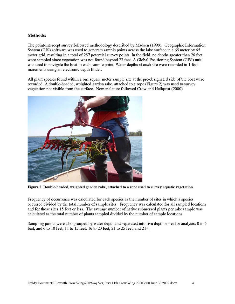
66 66
67 67
68 68
69 69
70 70
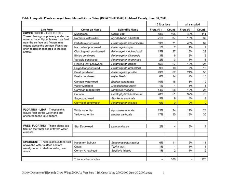
71 71
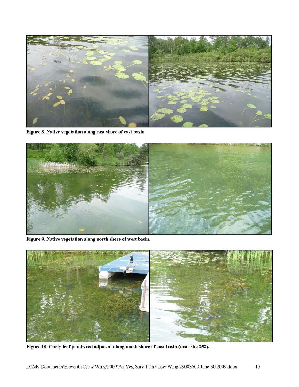
72 72
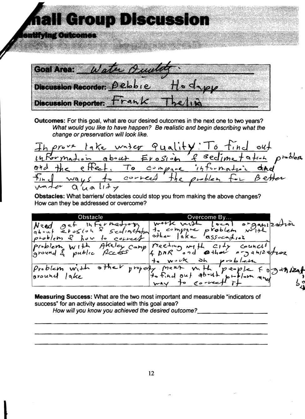
73 73
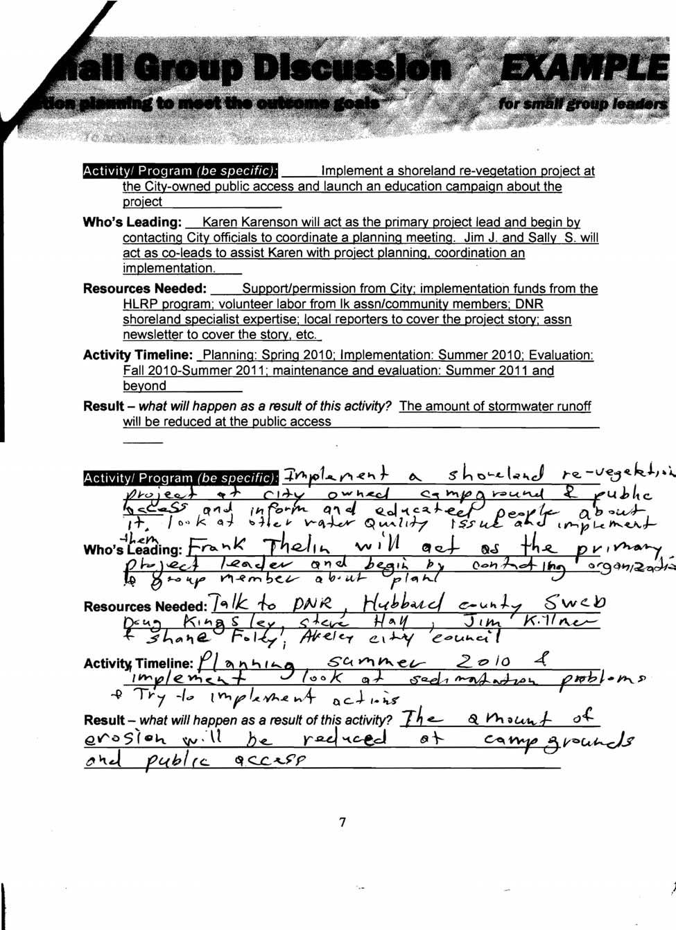
74 74
LAKE MANAGEMENT PLAN
 LAKE MANAGEMENT PLAN Region 1 Area Park Rapids D.O.W. Number 29-185 County Hubbard D.O.W. Lake Name Big Sand Lake Class 22 Acreage 1,635 GIS 465 littoral LONG RANGE GOALS: Maintain or improve the quality
LAKE DIANE Hillsdale County (T8-9S, R3W, Sections 34, 3, 4) Surveyed May Jeffrey J. Braunscheidel
 Surveyed May Jeffrey J. Braunscheidel") Michigan Department of Natural Resources Status of the Fishery Resource Report No. 2003-4, 2003 LAKE DIANE Hillsdale County (T8-9S, R3W, Sections 34, 3, 4) Surveyed May 2001 Jeffrey J. Braunscheidel Environment
Michigan Department of Natural Resources Status of the Fishery Resource Report No. 2003-4, 2003 LAKE DIANE Hillsdale County (T8-9S, R3W, Sections 34, 3, 4) Surveyed May 2001 Jeffrey J. Braunscheidel Environment
JadEco, LLC PO BOX 445 Shannon, IL 61078
 Introduction: With the assistance of Lake Holiday staff and volunteers, we were able to conduct an AC electrofishing survey on May 8, 27. Water temperatures were 2.3 C (8.5 F) and water clarity was decent
Crooked Lake Oakland County (T4N, R9E, Sections 3, 4, 9) Surveyed May James T. Francis
 Surveyed May James T. Francis") Michigan Department of Natural Resources Status of the Fishery Resource Report No. 2004-1, 2004 Crooked Lake Oakland County (T4N, R9E, Sections 3, 4, 9) Surveyed May 2002 James T. Francis Environment Crooked
Michigan Department of Natural Resources Status of the Fishery Resource Report No. 2004-1, 2004 Crooked Lake Oakland County (T4N, R9E, Sections 3, 4, 9) Surveyed May 2002 James T. Francis Environment Crooked
Current Status and Management Recommendations for the Fishery in the Cloverleaf Chain of Lakes
 Current Status and Management Recommendations for the Fishery in the Cloverleaf Chain of Lakes Jason Breeggemann Senior Fisheries Biologist Wisconsin Department of Natural Resources Outline DNR fisheries
LAKE MANAGEMENT PLAN
 LAKE MANAGEMENT PLAN Region Area DOW Number County DOW Lake Name Acreage 2 Duluth F213 69-0041 St. Louis Bassett DOW: 436 Plan: 442 Long Range Goal: Manage for walleye with a gillnet catch rate greater
BIG TWIN LAKE Kalkaska County (T28N, R05W, Section 18, and T28N, R06W, Section 13) Surveyed May 1999
 Surveyed May 1999") Michigan Department of Natural Resources Status of the Fishery Resource Report No. 2001-1, Year 2001 BIG TWIN LAKE Kalkaska County (T28N, R05W, Section 18, and T28N, R06W, Section 13) Surveyed May 1999
Michigan Department of Natural Resources Status of the Fishery Resource Report No. 2001-1, Year 2001 BIG TWIN LAKE Kalkaska County (T28N, R05W, Section 18, and T28N, R06W, Section 13) Surveyed May 1999
Introduction: JadEco, LLC PO BOX 445 Shannon, IL 61078
 Introduction: was contacted to collected data on the fishery for Lake Holiday. AC Electroshocking was conducted at 2 locations on September 28, 2015. Fish population data was collected for a total of 100
MEMORANDUM Comfort Lake-Forest Lake Watershed District
 MEMORANDUM Comfort Lake-Forest Lake Watershed District To: Board of Managers Date: December 7, 2016 From: Mike Kinney Subject: 2016 Watercraft Inspections and AIS Report Summaries Watercraft Inspection
MARTINDALE POND Wayne County 2004 Fish Management Report. Christopher C. Long Assistant Fisheries Biologist
 MARTINDALE POND Wayne County 2004 Fish Management Report Christopher C. Long Assistant Fisheries Biologist Fisheries Section Indiana Department of Natural Resources Division of Fish and Wildlife I.G.C.
MISSISSIPPI MAKEOVER A Plan for Restoration, Just Around the Bend
 MISSISSIPPI MAKEOVER A Plan for Restoration, Just Around the Bend Interim Report Card 2013 Project coordinated by the Dakota County Soil and Water Conservation District and sponsored by the Minnesota Pollution
2014 Island Lake Survey June 13 th, 2014 Andrew Plauck District Fisheries Biologist Report Prepared 4 March 2015
 2014 Island Lake Survey June 13 th, 2014 Andrew Plauck District Fisheries Biologist Report Prepared 4 March 2015 BACKGROUND - A fish survey was requested due to a moderately severe winterkill in Island
Summary of and Initial Response to public comments on MN Department of Natural Resources proposal to manage new waters for Muskellunge
 Summary of and Initial Response to public comments on MN Department of Natural Resources proposal to manage new waters for Muskellunge Summary of and Initial Response to public comments: This document
MIDDLE FORK RESERVOIR Wayne County 2004 Fish Management Report. Christopher C. Long Assistant Fisheries Biologist
 MIDDLE FORK RESERVOIR Wayne County 2004 Fish Management Report Christopher C. Long Assistant Fisheries Biologist FISHERIES SECTION INDIANA DEPARTMENT OF NATURAL RESOURCES DIVISION OF FISH AND WILDLIFE
Michigan Department of Natural Resources Status of the Fishery Resource Report Page 1
 Michigan Department of Natural Resources 2007-33 Status of the Fishery Resource Report Page 1 Grand Sable Lake Alger County, T49N, R14W, Sec. Many Lake Superior watershed, last year surveyed 2004 James
SKIATOOK LAKE MANAGEMENT PLAN
 SKIATOOK LAKE MANAGEMENT PLAN Background Skiatook Lake impounds Hominy Creek, 5 miles west of Skiatook in Osage County, Oklahoma (Figure 1). Skiatook Lake covers 10,540 surface acres and was constructed
Michigan Dept. of Natural Resources Status of the Fishery Resource Report Page 1. Weber Lake Cheboygan County, T34N, R3W, Sec.
 Michigan Dept. of Natural Resources 2012-143 Status of the Fishery Resource Report Page 1 Weber Lake Cheboygan County, T34N, R3W, Sec. 31 Neal Godby, Fisheries Biologist Environment Weber Lake is a 28.5-acre
Inventory # Perch Lake
 Inventory # 9-036 Perch Lake Perch Lake is a double-basin lake. The southern, shallow portion of the lake is 414 acres, making it the largest wild rice lake on the Reservation. The fish communities sampled
SOONER LAKE MANAGEMENT PLAN
 SOONER LAKE MANAGEMENT PLAN Background Lake Sooner impounds Greasy Creek, 15 miles south of Ponca City in Noble and Pawnee Counties, Oklahoma (Figure 1). The Grease Creek basin that Sooner Lake impounds
Cedar Lake Comprehensive Survey Report Steve Hogler and Steve Surendonk WDNR-Mishicot
 Cedar Lake- 2006 Comprehensive Survey Report Steve Hogler and Steve Surendonk WDNR-Mishicot ABSTRACT Cedar Lake is a 142 acre lake located in the southwest corner of Manitowoc County. It is a seepage lake
Status Review and Management Outline for Quality Bluegill and Black Crappie Populations in the Grand Rapids Area.
 Status Review and Management Outline for Quality Bluegill and Black Crappie Populations in the Grand Rapids Area. Revised in 2013 By David L. Weitzel Assistant Area Fisheries Supervisor MN DNR, Grand Rapids
CARL BLACKWELL LAKE MANAGEMENT PLAN
 CARL BLACKWELL LAKE MANAGEMENT PLAN Background Lake Carl Blackwell impounds Stillwater Creek, 10 miles west of Stillwater in Payne County, Oklahoma (Figure 1). The lake covers 3,370 surface acres and was
Fisheries Survey of White Rapids Flowage, Marinette County Wisconsin during Waterbody Identification Code
 Fisheries Survey of White Rapids Flowage, Marinette County Wisconsin during 25 Waterbody Identification Code 6343 Michael Donofrio Fisheries Supervisor Wisconsin Department of Natural Resources Peshtigo,
Current projects for Fisheries Research Unit of Minnesota Department of Natural Resources
 Current projects for Fisheries Research Unit of Minnesota Department of Natural Resources MAJOR RESOURCE ISSUES IN THE DIVISION OF FISHERIES Status of Fish Populations To effectively manage fish populations,
Lake information report
 Page of 5 Lake information report Name: Whitewater Nearest Town: Hoyt Lakes Primary County: St. Louis Survey Date: 08/3/2007 Inventory Number: 69037600 Public Access Information Ownership Type Description
Quemahoning Reservoir
 Pennsylvania Fish & Boat Commission Biologist Report Quemahoning Reservoir Somerset County May 2011 Trap Net, Gill Net and Electrofishing Survey Quemahoning Reservoir is an 899 acre impoundment located
CORRESPONDENCE/MEMORANDUM
 CORRESPONDENCE/MEMORANDUM State of Wisconsin DATE: November 13, 2012 FILE REF: [Click here and type file ref.] TO: FROM: Mike Donofrio Harpt Lake File Steve Hogler SUBJECT: 2012 Harpt Lake Electrofishing
Lake Winnibigoshish Fisheries Information Newsletter
 Lake Winnibigoshish Fisheries Information Newsletter 03/21/2016 An annual fisheries newsletter for Lake Winnibigoshish In This Issue 2016 Population Assessment Invasive Species VHS Interesting Links Invasive
DOW# West Twin Lake
 DOW# 69-0696 West Twin Lake West Twin Lake has a surface area of 120.4 acres and is located on the east side of St. Louis County Road 31, south of Highway 2. West Twin Lake has a maximum depth of 18 feet
Caro Impoundment, Tuscola County
 Caro Impoundment is a 200 acre impoundment of the Cass River located one mile south of the Village of Caro in Tuscola County. Caro Dam, originally constructed in 1906 for water supply to Michigan Sugar
Archer Lake 2011 Survey Report Prepared by Brian Gunderman
 Archer Lake 211 Survey Report Prepared by Brian Gunderman Introduction Archer Lake is a 64 acre lake located about miles southeast of the city of Coldwater. Archer Lake is part of the Coldwater-Marble
2010 Fishing Opener Prognosis. Central Region
 2010 Fishing Opener Prognosis Central Region Hinckley PINE COUNTY Pokegama, Cross, Island, Oak and North and South Big Pine Lakes are typically the best lakes for targeting walleye in Pine County. They
Aquatic Plant Management and Importance to Sport Fisheries
 Aquatic Plant Management and Importance to Sport Fisheries Presentation to Michigan Inland Lakes Convention May 2014 Mike Maceina Professor Emeritus School of Fisheries, Aquaculture, and Aquatic Sciences
Fish Survey of Goose Lake (ID # ), Ramsey County, Minnesota in 2012
, Ramsey County, Minnesota in 2012") Softshell Turtle from Goose Lake, July 2012 Fish Survey of Goose Lake (ID #62-0034), Ramsey County, Minnesota in 2012 Survey Dates: July 16-18, 2012 MnDNR Permit Number: 18362 Prepared for: VLAWMO and
Softshell Turtle from Goose Lake, July 2012 Fish Survey of Goose Lake (ID #62-0034), Ramsey County, Minnesota in 2012 Survey Dates: July 16-18, 2012 MnDNR Permit Number: 18362 Prepared for: VLAWMO and
I Region I Area I DOW Number / County I DOW Lake Name I Acreage I
 LAKE MANAGEMENT PLAN 814 Bp I Region I Area I DOW Number / County I DOW Lake Name I Acreage I I I # I f 2 Duluth F213 690036 St Louis Salo DOW:149 Plan: 137 Long Range Goal: Manage for walleye with a gillnet
Minnesota Department of Natural Resources
 Minnesota Department of Natural Resources Fisheries Management DRAFT VERSION - PRELIMINARY DATA (AS OF 7/7/) Lake Name: Bloody Survey Type: Standard Survey DOW Number: -4- Survey ID Date: 7// Lake Identification
Chagrin River TMDL Appendices. Appendix F
 Appendix F The following are excerpts from the Eastern Brook Trout Joint Venture s Conservation Strategy (Working Draft v.6), Conserving the Eastern Brook Trout: Strategies for Action Found at: http://www.easternbrooktrout.org/constrategy.html
Lake Management Plan For Long and Crooked Lakes
 Lake Management Plan For Long and Crooked Lakes Stearns County, Minnesota Revision History Date Description 6 June 2010 Original release for grant through Healthy Lakes & Rivers Partnership 24 May 2016
Leech Lake Update 5/20/2009 Walker Area Fisheries Office State Hwy. 371 NW Walker, MN
 Frequency (N) Leech Lake Update 5/20/2009 Walker Area Fisheries Office 07316 State Hwy. 371 NW Walker, MN 56484 218-547-1683 Greetings! This update is part of a series of reports the Minnesota Department
Fisheries and Lake Management Planning. CAP Mtg Nov21,2012 Brett Tregunno Aquatic Biologist, Kawartha Conservation
 Fisheries and Lake Management Planning CAP Mtg Nov21,2012 Brett Tregunno Aquatic Biologist, Kawartha Conservation Outline Aquatic Habitat Types Fish Communities Significance of Resource Current Management
Keuka Lake State of the Lake 2017
 Keuka Lake State of the Lake 2017 1 2 Lake Characteristics Third largest by area of the Finger Lakes 11,730 ac Deep and steep sided - max 185 ft mean 101 ft Two story fishery (warmwater/coldwater) 178,800
Lake information report
 Lake information report: Minnesota DNR Page of 5 Lake information report jf Prinlable senior Name: Spring Nearest Town: Spring Lake (Scott) Primary County: Scott Survey Date: 08/02/200 Inventory Number:
FISH COMMUNITIES AND FISHERIES OF THE THOUSAND ISLANDS AND MIDDLE CORRIDOR
 St. Lawrence River Discussion Paper FISH COMMUNITIES AND FISHERIES OF THE THOUSAND ISLANDS AND MIDDLE CORRIDOR Issues Below is a synopsis of fish community issues and proposed management approaches. More
LAKE PLEASANT Steuben County 2006 Fish Management Report. Larry A. Koza Assistant Fisheries Biologist
 LAKE PLEASANT Steuben County 2006 Fish Management Report Larry A. Koza Assistant Fisheries Biologist Fisheries Section Indiana Department of Natural Resources Division of Fish and Wildlife I.G.C.-South,
Upper/Lower Owl Creek Reservoir
 Upper/Lower Owl Creek Reservoir Schuylkill County 2018 Largemouth Bass Survey Upper Owl Creek Reservoir and Lower Owl Creek Reservoir are 67-acre and 26-acre impoundments, respectively, created by two
NURSERY POND Fish Management Report. Jason C. Doll Assistant Fisheries Biologist
 NURSERY POND 2004 Fish Management Report Jason C. Doll Assistant Fisheries Biologist FISHERIES SECTION INDIANA DEPARTMENT OF NATURAL RESOURCES DIVISION OF FISH AND WILDLIFE I.G.C. South, Room W273 402
Eastern Brook Trout. Roadmap to
 Eastern Brook Trout Roadmap to CONSERVATION Our Brook Trout heritage he wild Brook Trout is an American symbol of persistence, adaptability, and the pristine wilderness that covered North America prior
EcoLogic Memorandum. TO: Ben Brezell; EDR FROM: Mark Arrigo RE: Possible Impacts of Dredging Snooks Pond DATE: 6/4/07
 EcoLogic Memorandum TO: Ben Brezell; EDR FROM: Mark Arrigo RE: Possible Impacts of Dredging Snooks Pond DATE: 6/4/07 Background EDR P.C. (EDR) has been contracted by a landowner to assess the feasibility
LITTLE WHITE OAK Knox County 2006 Fish Management Report. Debbie King Assistant Fisheries Biologist
 LITTLE WHITE OAK Knox County 2006 Fish Management Report Debbie King Assistant Fisheries Biologist Fisheries Section Indiana Department of Natural Resources Division of Fish and Wildlife I.G.C.-South,
Overview of Recreational Pond Management
 Overview of Recreational Pond Management extension November 13 th 2013 Forrest Wynne State Extension Specialist for Aquaculture Kentucky State University Ponds are built for some of the following purposes:
RECREATIONAL PONDS AND LAKES
 RECREATIONAL PONDS AND LAKES POND ECOLOGY AQUATIC PLANTS & FISH F.S. Conte Department of Animal Science University of California Davis Photos By Flickr AQUATIC PLANTS POND HEALTH Chemical Recycling Oxygen
Categorical Exclusion Portage Lake Aquatic Organism Passage Project 1
 Letter- Comment Number Date Received Name/ Address Comment Response 1-1 2/7/2012 Bob Maurer 85 Blackmarr Rd. NE No comments N/A 2-1 2/8/2012 Judy Blackmarr 89 Blackmarr Rd. NE 2-2 2/8/2012 Judy Blackmarr
LAKE SURVEY REPORT DRAFT VERSION PRELIMINARY DATA (AS OF 08/30/2018) Fisheries Management. DOW Number: Survey ID Date: 08/27/2018
 Fisheries Management. DOW Number: Survey ID Date: 08/27/2018") Fisheries Management DRAFT VERSION PRELIMINARY DATA (AS OF 8/3/218) Lake Name: Wilmert (main bay) Survey Type: Standard Survey DOW Number: 6-1-1 Survey ID Date: 8/27/218 Lake Identification Alternate Lake
Fisheries Management DRAFT VERSION PRELIMINARY DATA (AS OF 8/3/218) Lake Name: Wilmert (main bay) Survey Type: Standard Survey DOW Number: 6-1-1 Survey ID Date: 8/27/218 Lake Identification Alternate Lake
Pennsylvania Fish & Boat Commission Biologist Report. Wilmore Dam. Cambria County. May 2011 Trap Net, Electrofishing and Hoop Net Survey
 Pennsylvania Fish & Boat Commission Biologist Report Wilmore Dam Cambria County May 2011 Trap Net, Electrofishing and Hoop Net Survey Wilmore Dam is a 195 acre impoundment located in central Cambria County
Fish Lake Informational Meeting. Dan Wilfond, Fisheries Specialist Deserae Hendrickson, Area Fisheries Supervisor MN DNR Fisheries - Duluth
 Fish Lake Informational Meeting Dan Wilfond, Fisheries Specialist Deserae Hendrickson, Area Fisheries Supervisor MN DNR Fisheries - Duluth Why are we here tonight? Provide background info on fish community
December 18, Dear Sir/Madam,
 December 18, 2000 Dear Sir/Madam, We are writing to bring you up-to-date on our efforts to develop fish community objectives for the St. Lawrence River. First of all, we want to thank you for participating
A SURVEY OF THE PRETTY LAKE FISH COMMUNITY, LARGEMOUTH BASS AND WALLEYE POPULATIONS AND FISH HARVEST LaGrange County 2010
 A SURVEY OF THE PRETTY LAKE FISH COMMUNITY, LARGEMOUTH BASS AND WALLEYE POPULATIONS AND FISH HARVEST LaGrange County 2010 Larry A. Koza Assistant Fisheries Biologist Fisheries Section Indiana Department
INLAND LAKE MANAGEMENT REPORT FY Spring 2008
 INLAND LAKE MANAGEMENT REPORT FY 2008 Spring 2008 Prepared by Robert O. Andress District Fisheries Biologist E. Daniel Catchings District Fisheries Supervisor Kevin W. Baswell District Biologist Aide Department
LAKE SURVEY REPORT DRAFT VERSION PRELIMINARY DATA (AS OF 08/24/2018) Fisheries Management. DOW Number: Survey ID Date: 08/21/2018
 Fisheries Management. DOW Number: Survey ID Date: 08/21/2018") Fisheries Management DRAFT VERSION PRELIMINARY DATA (AS OF 8//8) Lake Name: Sisseton Survey Type: Standard Survey DOW Number: 6-- Survey ID Date: 8//8 Lake Identification Alternate Lake Name: Primary Lake
Fisheries Management DRAFT VERSION PRELIMINARY DATA (AS OF 8//8) Lake Name: Sisseton Survey Type: Standard Survey DOW Number: 6-- Survey ID Date: 8//8 Lake Identification Alternate Lake Name: Primary Lake
MIDDLE FORK RESERVOIR Wayne County 2006 Fish Management Report. Christopher C. Long Assistant Fisheries Biologist
 MIDDLE FORK RESERVOIR Wayne County 2006 Fish Management Report Christopher C. Long Assistant Fisheries Biologist Fisheries Section Indiana Department of Natural Resources Division of Fish and Wildlife
NEVADA DEPARTMENT OF WILDLIFE STATEWIDE FISHERIES MANAGEMENT
 NEVADA DEPARTMENT OF WILDLIFE STATEWIDE FISHERIES MANAGEMENT FEDERAL AID JOB PROGRESS REPORTS F-20-48 2012 RYE PATCH RESERVOIR WESTERN REGION NEVADA DEPARTMENT OF WILDLIFE, FISHERIES DIVISION JOB PROGRESS
BEAUTIFUL... OR BLIGHTED? AN APPREHENSIVE LOOK AT OUR LAKESHORES
 BEAUTIFUL... OR BLIGHTED? AN APPREHENSIVE LOOK AT OUR LAKESHORES JACK SKRYP'EK * Trends indicate that all North Central Minnesota lakeshore will be fully developed by the mid-1970's. * Is indiscriminate
Columbia Lake Dam Removal Project
 Columbia Lake Dam Removal Project The Columbia Lake dam located 1/4 mile upstream of the Paulins Kill River's confluence with the Delaware River in Knowlton Township, Warren County has been proposed for
Tips for Using & Printing Spreadsheets
 Key to Spreadsheets Spreadsheet # Type Description/Purpose a Development & Construction in Waterways b Debits Development & Construction in Other Aquatic Areas c Indirect Impacts to Waterways from Development
MINNESOTA DEPARTMENT OF NATURAL RESOURCES DIVISION OF FISHERIES AND WILDLIFE. Gamefish Assessment Report
 Minnesota DNR F-29-R(P) Area F312 February 1, 2013 MINNESOTA DEPARTMENT OF NATURAL RESOURCES DIVISION OF FISHERIES AND WILDLIFE Gamefish Assessment Report Spring Gamefish Assessment on the Mississippi
Minnesota Department of Natural Resources Division of Fish and Wildlife Section of Fisheries. Stream Survey Report. Three Mile Creek 2011
 Minnesota Department of Natural Resources Division of Fish and Wildlife Section of Fisheries Stream Survey Report Three Mile Creek 2011 By Joseph D. Stewig Montrose Area Fisheries Office TABLE OF CONTENTS
Fish Community. Fish Habitat, Streams and Rivers
 Clear, Ston(e)y and White Lake Plan Fish Community The lakes support a cool/warm water fishery including muskellunge, walleye, largemouth and smallmouth bass, yellow perch, pumpkinseed, rockbass, blue
Dauphin Lake Fishery. Status of Walleye Stocks and Conservation Measures
 Dauphin Lake Fishery Status of Walleye Stocks and Conservation Measures Date: December, 21 Dauphin Lake Fishery Status of Walleye Stocks and Conservation Measures Background: Walleye stocks in Dauphin
Lake information report
 Page 1 of 6 Lake information report Name: Saganaga Nearest Town: Grand Marais Primary County: Cook Survey Date: 08/08/2011 Inventory Number: 16063300 walleye stocking. Purchase a walleye stamp. Your voluntary
DRIPPING SPRINGS LAKE 5 YEAR LAKE MANAGEMENT PLAN
 DRIPPING SPRINGS LAKE 5 YEAR LAKE MANAGEMENT PLAN FISHERIES DIVISION CENTRAL REGION OKLAHOMA DEPTMENT OF WILDLIFE CONSERVATION PREPARED BY: DANNY BOWEN OCTOBER 2013 1 Background Dripping Springs Lake impounds
Fish Survey of Arctic Lake (ID # ), Scott County, Minnesota in 2012
, Scott County, Minnesota in 2012") Snapping Turtle from Arctic Lake, September 2012 Fish Survey of Arctic Lake (ID #70-0085), Scott County, Minnesota in 2012 Survey Dates: September 18-20, 2012 MnDNR Permit Number: 18362 Prepared for: Shakopee
Snapping Turtle from Arctic Lake, September 2012 Fish Survey of Arctic Lake (ID #70-0085), Scott County, Minnesota in 2012 Survey Dates: September 18-20, 2012 MnDNR Permit Number: 18362 Prepared for: Shakopee
Busse Reservoir South Lateral Pool Population Survey
 Busse Reservoir South Lateral Pool Survey Located in Elk Grove Village south of Higgins Rd. between RT 53/I-290 and Arlington Heights Rd. Busse Reservoir is comprised of three pools making up a total of
Waubee Lake Kosciusko County Fish Management Report 2006
 Waubee Lake Kosciusko County Fish Management Report 2006 Jed Pearson, fisheries biologist Fisheries Section Indiana Department of Natural Resources Division of Fish and Wildlife I.G.C.-South, Room W273
Healthy lakes add value to our communities. They provide a place to relax and recreate,
 Big Bass Lake Eastern Marathon County Lake Study Final Study Results 2013 University of Wisconsin-Stevens Point and Marathon County Staff and Citizens Healthy lakes add value to our communities. They provide
Aquatic Plant Point-Intercept Survey for Pike Lake, Scott County, Minnesota
 Campers on Pike Lake, Scott County, Minnesota, 2015 Aquatic Plant Point-Intercept Survey for Pike Lake, Scott County, Minnesota [Plant Survey Conducted August 24, 2015] Prepared for: Prior Lake/Spring
First Nations Fish Habitat Program Discussion Workbook
 First Nations Fish Habitat Program Discussion Workbook The First Nations Fish Habitat Program is a joint initiative of the Centre for Indigenous Environmental Resources (CIER) and The Southern Chiefs Organization
Alcona Dam Pond Alcona County (T25N, R5E, Sections various) Surveyed June 6-12 and September 16, 2003
 Surveyed June 6-12 and September 16, 2003") Michigan Department of Natural Resources Status of the Fishery Resource Report No. 2004-6, Year 2004 Alcona Dam Pond Alcona County (T25N, R5E, Sections various) Surveyed June 6-12 and September 16, 2003
Michigan Department of Natural Resources Status of the Fishery Resource Report No. 2004-6, Year 2004 Alcona Dam Pond Alcona County (T25N, R5E, Sections various) Surveyed June 6-12 and September 16, 2003
Maryland Chapter Trout Unlimited Brook Trout Conservation Effort
 Maryland Chapter Trout Unlimited Brook Trout Conservation Effort Photo by Matt Kline Portfolio of Recent Work MDTU Brook Trout Conservation Coordinator: Scott C. Scarfone, ASLA sscarfone@oasisdesigngroup.com
NEVADA DEPARTMENT OF WILDLIFE STATEWIDE FISHERIES MANAGEMENT
 NEVADA DEPARTMENT OF WILDLIFE STATEWIDE FISHERIES MANAGEMENT FEDERAL AID JOB PROGRESS REPORTS F-2-52 216 CHIMNEY RESERVOIR WESTERN REGION NEVADA DEPARTMENT OF WILDLIFE, FISHERIES DIVISION JOB PROGRESS
LOGAN MARTIN RESERVOIR MANAGEMENT REPORT. Prepared by. E. Daniel Catchings District Fisheries Supervisor
 LOGAN MARTIN RESERVOIR MANAGEMENT REPORT 2008 Prepared by E. Daniel Catchings District Fisheries Supervisor Robert O. Andress District Fisheries Biologist Department of Conservation and Natural Resources
Penny Road Pond Population Survey
 Located in Barrington Hills on the south side of Penny Rd. west of Old Sutton Rd. This small 7 acre pond has a maximum depth of 4.6 feet and is connected to Spring Creek. The fish population of Penny Road
Comprehensive Fisheries Survey of High Falls Reservoir, Marinette County Wisconsin during 2004 and Waterbody Identification Code
 Comprehensive Fisheries of High Falls Reservoir, Marinette County Wisconsin during 2004 and 2005 Waterbody Identification Code 540600 Justine Hasz Senior Fisheries Biologist Wisconsin Department of Natural
Minnesota Department of Natural Resources Division of Fisheries and Wildlife
 Minnesota Department of Natural Resources Division of Fisheries and Wildlife Completion Report Evaluation of Centrarchid Populations throughout Leech Lake 215 by Matt Ward Walker Area Fisheries Office
Wild Virginia and Heartwood first raised this issue at the May 19, 2014 public meeting.
 June 13, 2014 Karen Stevens Pat Sheridan, District Ranger Warm Springs Ranger District 422 Forestry Road Hot Springs, VA 24445 karenlstevens@fs.fed.us psheridan@fs.fed.us re: Lower Cowpasture Restoration
Sebec Lake Fisheries Management Plan 2012
 Sebec Lake Fisheries Management Plan 2012 Sebec Lake is a 6,800-acre oligotrophic lake located in northwestern Maine. It has popular fisheries for landlocked salmon, lake trout, and smallmouth bass. Other
Trout Unlimited Comments on the Scope of Environmental Impact Statement for the Constitution Pipeline Project, Docket No. PF12-9
 October 9, 2012 Kimberly D. Bose, Secretary Federal Energy Regulatory Commission 888 First Street, NE, Room 1A Washington, DC 20426 RE: Trout Unlimited Comments on the Scope of Environmental Impact Statement
5B. Management of invasive species in the Cosumnes and Mokelumne River Basins
 5B. Management of invasive species in the Cosumnes and Mokelumne River Basins Cosumnes River The Cosumnes River basin has a number of distinct habitat types that require different management strategies
East Metro Forest Lake (2,251 acres): Coon Lake (1,481 acres):
: Coon Lake (1,481 acres):") East Metro Forest Lake (2,251 acres): Located within the City of Forest Lake and just east of Interstate 35, Forest Lake boasts good numbers of northern pike and walleye. Northern pike and walleye were
East Metro Forest Lake (2,251 acres): Located within the City of Forest Lake and just east of Interstate 35, Forest Lake boasts good numbers of northern pike and walleye. Northern pike and walleye were
Black Sturgeon Regional Plan
 Black Sturgeon Regional Plan This is one of twenty Regional Plans that support implementation of the Lake Superior Biodiversity Conservation Strategy (Strategy). The Strategy, prepared and overseen by
Fish Community and Aquatic Ecosystem Responses to the Cessation of Eurasian Watermilfoil Chemical Treatment on Lake Ellwood, Wisconsin
 Fish Community and Aquatic Ecosystem Responses to the Cessation of Eurasian Watermilfoil Chemical Treatment on Lake Ellwood, Wisconsin Greg G. Sass Wisconsin Department of Natural Resources Fisheries and
Crawford Reservoir. FISH SURVEY AND MANAGEMENT INFORMATION Eric Gardunio, Fish Biologist Montrose Service Center
 FISH SURVEY AND MANAGEMENT INFORMATION General Information: Crawford Reservoir is a popular fishery that provides angling opportunity for yellow perch, channel catfish, northern pike, rainbow trout, black
Mark A. Tonello and Ralph L. Hay
 Michigan Department of Natural Resources Status of the Fishery Resource Report No. 2003-3, 2003 Fife Lake Grand Traverse County (T25N, R09W, Section 13) Surveyed June 4-8, 2001 Mark A. Tonello and Ralph
Big Bend Lake Population Survey
 Big Bend Lake Survey Located in Des Plaines on East River Rd. just south of Golf Rd. This 27 acre body of water has a depth of 27.8 feet; however because it is connected to the Des Plaines River by a spillway,
Minnesota Department of Natural Resources
 Minnesota Department of Natural Resources Fisheries Management Lake Name: Colby Survey Type: Population Assessment DOW Number: 699 Survey ID Date: 7// Lake Identification Alternate Lake Name: Partridge
Rolling Knolls Pond Population Survey
 Located near the town of Elgin on the west side of Rohrssen Rd. between Illinois Route 58 and U.S.- 20. This small 1.8 acre pond has a maximum depth of 7.5 feet and is occasionally influenced by Poplar
Michigan Dept. of Natural Resources Status of the Fishery Resource Report Page 1
 Michigan Dept. of Natural Resources 2014-197 Status of the Fishery Resource Report Page 1 Otter Lake Lapeer and Genesee Counties, T9,10N/R8,9E/ Sections 1,6,7,36 Flint River Watershed, Last surveyed 2014
Proposed Changes to Bag and Size Limits Minnesota/Wisconsin Border Waters of the Mississippi River
 Proposed Changes to Bag and Size Limits Minnesota/Wisconsin Border Waters of the Mississippi River The Minnesota and Wisconsin DNRs are jointly reviewing fishing regulations on Pools 3-9 of the Mississippi
Tampier Lake Population Survey
 Located in Palos Park on 131 st St. between Wolf and Will-Cook Rd. s. Tampier Lake has 131 acres of fishable water, with a maximum depth of 9.4 feet. Walleye, northern pike, largemouth bass and channel
Sag Quarry - West Population Survey
 Located in Lemont on RT 83 and Archer Ave. just north of 111 th St. Like Sag Quarry East, this lake is an old limestone quarry, 14 acres in size and with a maximum depth of 10.3 feet. The species found
Starry Stonewort in Silver Lake Washington County, WI BRAD STECKART AIS COORDINATOR FOR WASHINGTON AND WAUKESHA COUNTIES
 Starry Stonewort in Silver Lake Washington County, WI BRAD STECKART AIS COORDINATOR FOR WASHINGTON AND WAUKESHA COUNTIES Brad Steckart -AIS coordinator for Washington and Waukesha Counties -Graduated from