TAKE A KID FISHING! Enjoy the outdoors with kids!
|
|
|
- Harvey Bell
- 6 years ago
- Views:
Transcription

1

2 TAKE A KID FISHING! Enjoy the outdoors with kids! The Forest Preserves of Cook County offers family events and fishing derbies throughout the year to introduce children to the joys of fishing. Visit fpdcc.com/events to learn about all of our events. The Illinois Department of Natural Resources also provides information about kids and family fishing. Visit dnr.illinois.gov/fishing to learn more.
3 TABLE OF CONTENTS Guide to Fishing in the Forest Preserves Rules & Regulations, Illegal Actions Boating Countywide Map of Fishing Lakes Index & Locations of the Designated Fishing Lakes Lake Maps Fishing Guide Table Used Fishing Line Common Fishes of Cook County Fish Consumption Advisory & V.H.S. Aquatic Nuisance Species Asian Carp The Forest Preserves of Cook County would like to acknowledge and thank the following agencies for their help in the creation, design and content of this publication: Cook County Geographic Information Systems (GIS), Bureau of Technology, and the Cook County Department of Public Affairs and Communications, Office of the President, Cook County Board.

4 GUIDE TO FISHING IN THE FOREST PRESERVES OF COOK COUNTY This guide lists lakes and waters open to public fishing in the Forest Preserves of Cook County. Fishing at lakes not listed in this book is prohibited. Individual maps show the location and depths of each lake, and list principal fish species. Hard-surfaced paths for accessibility from parking lots to fishing walls may be found at Busse Lake, Flatfoot Lake, Saganashkee Slough, Tampier Lake, and the Skokie Lagoons. As part of the mission to preserve and protect natural lands for the education, pleasure and recreation of the public, the FPCC provides a variety of fishing opportunities for families and individual of all ages and abilities. Some fishing waters are natural, some have been created by damming streams, and others were dug during highway construction. Sale of fishing licenses and federal taxes on fishing equipment have provided funding for District fishing programs. Over,000 acres of fishing water, in over 0 areas, are now available. The District conducts an ongoing program of fisheries management, shoreline improvement, nuisance aquatic vegetation control, and other projects to enhance fishing enjoyment. Individual lakes may be closed at times for stocking or other management activities. Management focuses on providing the best possible shoreline fishing, while offering boating on some lakes. Limited nuisance vegetation control improves aesthetic values and makes shoreline fishing easier. Other management activities include periodic sampling to determine populations, reproduction and growth, and species relationships, and stocking. You, the angler, can help by obeying size and creel limits, and other regulations that contribute to good fishing for all. Please pick up all bait containers and other litter, and remember that discarded line and hooks are a serious hazard to wildlife and other people. REGULATIONS The District works with the Illinois Department of Natural Resources to provide quality fishing. All state laws and rules apply to District waters, with some additional restrictions: bow and arrow fishing is not permitted in District preserves, and all forest preserve waters are designated fish preserves, each fisherman is limited to two lines with no more than two hooks per line, and no trolley lines. This includes ice fishing. A valid Illinois hook and line fishing license is required except for persons under age, disabled, or blind. A State Inland Trout Stamp is required with each license, when fishing for trout in Forest Preserves trout lakes.


5 The following size and creel limits pertain to District waters: Largemouth or Smallmouth Bass per day, minimum length inches Walleye per day, minimum length inches Channel Catfish per day, no length minimum Northern Pike per day, minimum length inches White, Black or Hybrid Crappie per day, no length minimum Bluegill, Redear, Pumpkinseed Sunfish per day, no length minimum Muskellunge per day, minimum length inches Trout per day, no length minimum ICE FISHING is permitted on designated District lakes on a FISH AT YOUR OWN RISK basis. Ice conditions are not monitored by the District. A minimum of inches of solid ice over the entire lake is recommended for safety. Two-pole limit. TROUT FISHING is closed from March to the first Saturday in April, and from October to the third Saturday in October. The use of a minnow seine is not allowed, except for bait collecting in the Des Plaines River. ILLEGAL ACTIONS It is unlawful to release any fish, including minnows and goldfish, in any Forest Preserves of Cook County waters, except in the waters from which they were taken. It is illegal to abandon, deposit or throw any wire, can, bottle, glass, paper, trash, rubbish, cardboard boxes, wood cartons, trees, parts of trees, brush or other insoluble material, including animal or vegetable material, into the waters or on the ice of any waters of Cook County, or in any place on the banks of waters in the County, where it shall be liable to be washed into the waters by storms, floods or other causes. Tournament fishing is prohibited. IT IS UNLAWFUL TO ENTER THE WATER FOR ANY REASON, INCLUDING WADING OR SWIMMING, UNLESS AUTHORIZED BY ADMINISTRATIVE ORDER OF THE GENERAL SUPERINTENDENT. BOATING GENERAL REGULATIONS: Permitted on designated water bodies: non-gasoline powered watercraft of either traditional construction, or multi-chambered inflatables with a factory installed floor and hull identification number, including sailboats, rowboats, canoes and kayaks. Radio controlled boats, floatplanes and paddle boards on designated lakes only. All such watercraft must be registered and titled with the Illinois Department of Natural Resources or state of residence and must display registration or Water Usage Stamp in accordance with the regulations and laws of the State of Illinois or the state of residence. All watercraft must carry the appropriate personal floatation devices for that watercraft as dictated by Federal and state laws.


6 MOTORBOATS RESTRICTED: No person shall, at any time, bring any gasoline or other fuel powered boat or outboards into or upon any waters under exclusive control of the Board of Commissioners. Electric or battery powered trolling motors shall not be used in or upon waters except at such place or places as may be provided or designated for such purpose by administrative order of the General Superintendent of the Forest Preserve District. ILLEGAL FLOATATION DEVICES: It is illegal to use or bring into or upon any of the waters under the exclusive control of the Board of Commissioners; any watercraft or floatation devices other than those listed under the General Regulations above. Prohibited floatation devices include but are not limited to inner-tubes, fly-fishing float-tubes or pontoons, sailsurf boards, towables or inflatable pool toys, lounges or rafts. BOATING WATERS: No private watercraft is allowed on District waters, except as listed below. No private watercraft is permitted on District waters overnight. ACCEPTABLE WATERCRAFT OUTBOARD MOTORS ALLOWED DES PLAINES RIVER: for all watercraft. One ramp at Plank Road Meadow, Ogden Avenue and First Avenue, Lyons. Carry-in launch ramps at Allison Woods, Prospect Heights; Stony Ford, Lyons; Columbia Woods, Willow Springs; Lemont Landing, Lemont; Irving Park Road Canoe Landing, Schiller Park; Dam #, Mt. Prospect SALT CREEK: Carry-in launch ramps at Bemis Woods North, Westchester; th Street Woods West, LaGrange Park CHICAGO RIVER: Carry-in launch ramp at Linne Woods, Morton Grove LITTLE CALUMET RIVER: for all watercraft. Two ramps; Little Calumet Boat Launch north of Jackson St. east of Ashland, Riverdale; Beaubien Woods Boat Launch south of 0th St, west of Bishop Ford Expressway, Chicago. ELECTRIC MOTORS ONLY (GAS MOTORS MUST BE REMOVED FROM WATERCRAFT) BECK LAKE: canoes, kayaks, rowboats, sailboats; Central & River Rd, Des Plaines BIG BEND LAKE: canoes, kayaks, rowboats, sailboats; East River Rd, south of Golf Rd, Des Plaines BUSSE LAKE: canoes, kayaks, rowboats, sailboats permitted in Main Lake & South Pool, ramps in both. Boat rental at Main Lake. Higgins Rd & I-90, Elk Grove Village MAPLE LAKE: rowboat rental, no private boats; Wolf Rd. & 9th St, Willow Springs POWDERHORN LAKE: canoes, kayaks, rowboats, sailboats; Brainard Ave. east of Burnham Ave, Chicago SAGANASHKEE SLOUGH: canoes, kayaks, rowboats; boat launch at west parking lot, th Street, between Archer Ave. & Willow Springs Road SKOKIE LAGOONS: canoes, kayaks, rowboats, sailboats; canoe/kayak rental; between Dundee & Willow Roads, east of the Edens Expressway TAMPIER LAKE: canoes, kayaks, rowboats; boat rental; st Street, west of Wolf Road, Orland Park
7 DESIGNATED FISHING LAKES Glencoe Potawatomi Pond Barrington Hills Skokie Lagoons Northbrook Wheeling Tower Road Canoe & Kayak Rental Palatine RENTAL Tower Road Boat Launch Deer Grove Lake Allison Woods Glenview Penny Road Pond 9 Dam No. Woods Arlington Heights South Barrington Beverly Lake Wilmette 9 Beck Lake Mount Prospect Evanston 90 Skokie Big Bend Lake Busse Reservoir & Boating Center RENTAL Barrington Road Pond Linne Woods Niles Belleau Lake Des Plaines Bode Lake North & South Elgin Schaumburg Lincolnwood Axehead Lake Elk Grove Village Bartlett Lake Michicagn 90 Norridge Schiller Park WATERBODY Page Schiller Pond Irving Park Road Canoe Landing Arrowhead Lake, Palos Heights Axehead Lake, Park Ridge Franklin Park Barrington Road Pond, Hoffman Estates 9 Beck Lake, Des Plaines Thatcher Pond 90 Melrose Park Belleau Lake, Park Ridge 9 Oak Park Hillside 90 Chicago Forest Park Cicero Westchester Stony Ford Canoe Landing Twenty-Sixth Street Woods West Bemis Woods North Belly Deep Slough, Palos Hills Beverly Lake, Hoffman Estates Big Bend Lake, Des Plaines Bode Lake North & South, Hoffman Estates - Brookfield Cermak Quarry La Grange Plank Road Meadow Boat Launch Bullfrog Lake, Willow Springs Busse Reservoir, Elk Grove Village - Cermak Quarry, Lyons Summit Ida Lake Deer Grove Lake, Palatine -- Columbia Woods Flatfoot Lake, Chicago Burbank Maple Lake & Boating Center Green Lake, Calumet City RENTAL Horsetail Lake, Palos Park
8 Ida Lake, Countryside Joe s Pond, Willow Springs 9 Maple Lake, Willow Springs McGinty Slough, Lemont Midlothian Reservoir, Oak Forest O Malley Ponds, Sauk Village Papoose Lake, Palos Park Penny Road Pond, Barrington Hills Potawatomi Pond, Wheeling Powderhorn Lake, Chicago 9 Sag Quarries East & West, Lemont 0- Saganashkee Slough, Palos Hills - Sauk Lake, Chicago Heights Schiller Pond, Schiller Park Skokie Lagoons, Glencoe & Winnetka -0 Tampier Lake (South of st St.), Palos Park - Thatcher Pond, River Forest -- Tryner s Pond, Tinley Park Tuma Lake, Willow Springs Turtlehead Lake & Ponds, Palos Heights Wampum Lake, Thornton RENTAL Boat Rental Waterbody Boat Ramp Canoe Landing Waterway Boat Ramp Miles 0 Sag Quarries East & West Lemont RENTAL Bullfrog Lake Belly Deep Slough McGinty Slough Tampier Lake & Boating Center Orland Park Tuma Lake Joe s Pond Horsetail Lake Papoose Lake 9 Palos Heights Oak Lawn Saganashkee Slough Arrowhead Lake Turtlehead Lake Oak Forest Alsip Harvey 9 Beaubien Woods Boat Launch Little Calumet Boat Launch Flatfoot Lake 9 90 Powderhorn Lake Calumet City WATERWAY ACCESS Midlothian Reservoir Tinley Park 0 Markham Tryner s Pond Flossmoor Wampum Lake South Holland 0 Glenwood Green Lake Lansing North Branch of the Chicago River Tower Road Boat Launch, Northfield Linne Woods, Morton Grove Des Plaines River Allison Woods, Prospect Heights Dam No. Woods, Mount Prospect Irving Park Road Canoe Landing, Schiller Park Plank Road Meadow Boat Launch, Lyons Stony Ford Canoe Landing, Lyons Columbia Woods, Willow Springs Matteson Park Forest Sauk Lake 9 Sauk Village O Malley Pond 0 Salt Creek Bemis Woods North, Proviso Township Twenty-Sixth Street Woods West, LaGrange Park Calumet & Little Calumet Rivers Beaubien Woods Boat Launch, Chicago Little Calumet Boat Launch, Riverdale
9 Map Index of the Designated Fishing Lakes Forest Preserves of Cook County ) ARROWHEAD LAKE: Palos Heights; th St, east of Harlem Ave. Page ) AXEHEAD LAKE: Park Ridge; Touhy Ave., east of River Rd. and the Tri-State Tollway (I-9). Page ) BARRINGTON ROAD POND: Hoffman Estates; Barrington Rd, south of Higgins Rd. Page 9 ) BECK LAKE: Des Plaines; Central Rd, between River Rd and the Tri-State Tollway (I-9). Page ) BELLEAU LAKE: Park Ridge; Busse Highway, west of the Tri-State Tollway (I-9). Page ) BELLY DEEP SLOUGH: Palos Hills; LaGrange Rd (U.S. Route ), / mile south of 9th St. Page ) BEVERLY LAKE: Hoffman Estates; Higgins Rd, west of Beverly Rd. Page ) BIG BEND LAKE: Des Plaines; East River Rd, south of Golf Rd. Page 9) BODE LAKES: Hoffman Estates; Bode Rd, mile west of Barrington Rd. Pages - ) BULLFROG LAKE: Willow Springs; Wolf Rd, south of 9th St. Page ) BUSSE RESERVOIR: Elk Grove Village; Higgins Rd, east of RT-/I-90. Pages - ) CERMAK QUARRY: Lyons; Ogden Av, ½ mile west of Harlem Ave. Page ) DEER GROVE LAKE: Palatine; Quentin Rd, north of Dundee Rd (in Deer Grove Preserve West) NO CONTOUR MAP AVAILABLE FOR DEER GROVE LAKE. ) FLATFOOT LAKE: Chicago; entrance from eastbound I-9, south of 0th St. (in Beaubien Woods). Page ) GREEN LAKE: Calumet City; north of 9th St, east of Torrence Ave. Page ) HORSETAIL LAKE: Palos Park; Willow Springs Rd. (th Ave.), north of McCarthy Rd. Page ) IDA LAKE: Countryside; LaGrange Rd. (U.S. ), north of th St. Page ) JOE S POND: Willow Springs; Willow Springs Rd (th Ave.), mile south of 9th St. Page 9 9) MAPLE LAKE: Willow Springs; Wolf Rd. and 9th St. Page 0) MCGINTY SLOUGH: Lemont; north of st St, west of Will-Cook Rd. Page ) MIDLOTHIAN RESERVOIR: Oak Forest; th St., west of Cicero Ave. Page ) O MALLEY PONDS: Sauk Village; Sauk Trail Rd., west of Burnham Ave. Page ) PAPOOSE LAKE: Palos Park; McCarthy Rd. (rd St.), west of LaGrange Rd. (U.S. ). Page ) PENNY ROAD POND: Barrington Hills; Penny Rd., west of Old Sutton Rd. Page ) POTAWATOMI POND: Wheeling; Dundee Rd., east of Milwaukee Ave. Page ) POWDERHORN LAKE: Chicago; Brainard Ave., east of Burnham Ave. Page 9 ) SAG QUARRIES EAST AND WEST: Lemont; Route- and Archer Ave., at th St. Pages 0- ) SAGANASHKEE SLOUGH: Palos Hills; Willow Springs Rd. (th Ave.) and th St. Pages - 9) SAUK LAKE: Chicago Heights; north of Sauk Trail Rd., west of Euclid Ave., and south of th St. Page 0) SCHILLER POND: Schiller Park; Irving Park Rd., west of Cumberland Ave. Page ) SKOKIE LAGOONS: Glencoe/Winnetka; Forestway Drive between Willow and Dundee Roads, and east of Edens Expressway (I-9). Pages -0 ) THATCHER POND: River Forest; Chicago Ave, west of Thatcher Ave. NO CONTOUR MAP AVAILABLE FOR THATCHER POND. ) TAMPIER LAKE: Palos Park; st St. between Wolf & Will-Cook Roads. Pages - ) TRYNER S POND: Tinley Park; Central Ave, south of th St. Page ) TUMA LAKE: Willow Springs; Willow Springs Rd. (th Av), between 9th St and th St. Page ) TURTLEHEAD LAKE AND PONDS: Palos Heights; Harlem Ave., south of th St. Page ) WAMPUM LAKE: Thornton; Thornton-Lansing Rd., ½ mile west of Torrence Ave. Page


10 Paved Trail Parking To st Steet Arrowhead Lake Water depth contour interval: ft. ft. Index Contour ft. Intermediate Contour Depression Contour Spot Depth (ft.) Shoreline elevation =. feet Lake size = acres 0 Feet :,00


11 9 Ramp Tri-State Tollway To Touhy Ave. Parking 0 Des Plaines River Rd. Axehead Lake Water depth contour interval: ft. ft. Index Contour ft. Intermediate Contour Depression Contour Spot Depth (ft.) Shoreline elevation =. feet Lake size = acres 0 Feet Parking Spring and Fall Inland Trout Program - Opens st Saturday in April and rd Saturday in October :,00


12 Barrington Road Paved Trail To Parking Picnic Shelter Barrington Road Pond. Water depth contour interval: ft. ft. Index Contour ft. Intermediate Contour Depression Contour Spot Depth (ft.) Shoreline elevation =. feet Lake size = acres Feet 9 :,00

 Shoreline elevation =.")
13 Beck Lake Water depth contour interval: ft.... ft. Index Contour ft. Intermediate Contour Depression Contour Spot Depth (ft.) Shoreline elevation =. feet Lake size = acres Boat Ramp Parking To Central Road Feet :,00

 Shoreline elevation =.")
14 0 0 9 Tri State Tollway Belleau Lake Water depth contour interval: ft. Spring and Fall Inland Trout Program - Opens st Saturday in April and rd Saturday in October To Parking and Busse Highway 0 ft. Index Contour ft. Intermediate Contour Depression Contour Spot Depth (ft.) Shoreline elevation =. feet Lake size = acres 0 Feet :,000

 Shoreline elevation =.")
15 Kean Avenue Belly Deep Slough Water depth contour interval: ft. ft. Intermediate Contour Depression Contour Spot Depth (ft.) Shoreline elevation =. feet Lake size = acres 9th Avenue - Route Parking.. 0 Feet :,000

16


17 Golf Road - Route Boat Ramp Parking To East River Road Des Plaines River Spillway Big Bend Lake Water depth contour interval: ft. ft. Index Contour ft. Intermediate Contour Depression Contour Spot Depth (ft.) Shoreline elevation =. feet Lake size = acres 0 00 Feet :,00

18

19


20 To Maple Lake Parking Bullfrog La ke Water depth contour interval: ft. ft. Index Contour ft. Intermediate Contour Depression Contour Spot Depth (ft.) Shoreline elevation =. feet Lake size = acres Feet :,00
21

22 9

23 0

24

25

 Shoreline elevation =.")
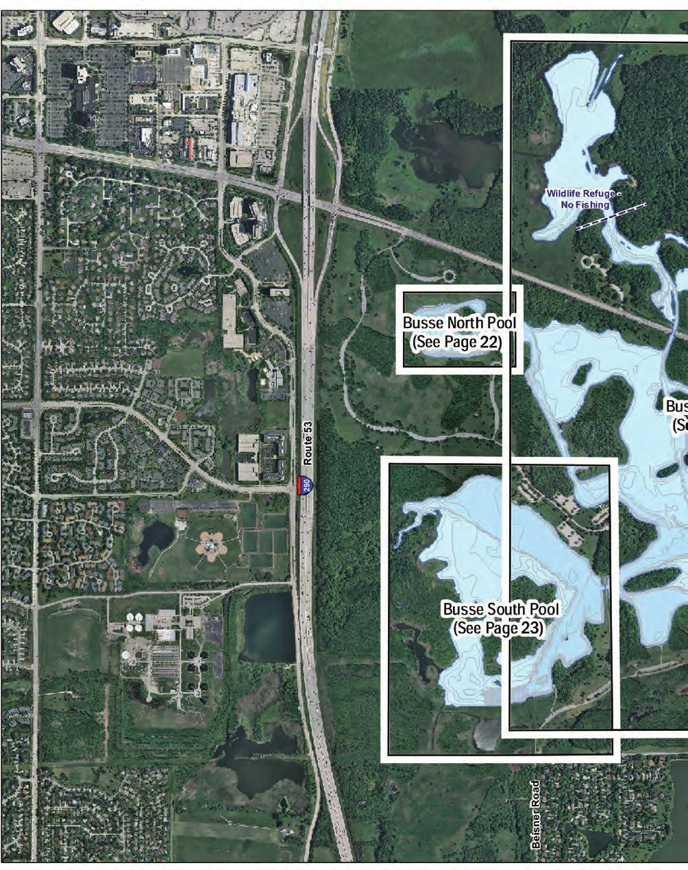
26 . To Higgi ns Road Parking Busse Main Pool (See Pages 0-) Parking.. Parking Salt Creek. Boat Ramp South Dam Fishing Wall. 9. Parking Busse South Pool Water depth contour interval: ft. To Biesterfield Road ft. Index Contour ft. Intermediate Contour Depression Contour Spot Depth (ft.) Shoreline elevation =. feet Lake size = acres Feet :,00


27 .. 9 To Ogden Avenue. Cermak Quarry Water depth contour interval: ft. ft. Index Contour ft. Intermediate Contour Depression Contour Spot Depth (ft.) Shoreline elevation = 99. feet Lake size = acres PavedTrail Feet :00 Parking

 Shoreline elevation =. feet Lake size = 9 acres 0 00 Feet :,00")
28 Bishop Ford Freeway. Parking Fishing Pier Picnic Shelter.... To I - 9 Illinois Harbor belt R.R. Co Little Calumet River Flatfoot Lake Water depth contour interval: ft. ft. Index Contour ft. Intermediate Contour Depression Contour Spot Depth (ft.) Shoreline elevation =. feet Lake size = 9 acres 0 00 Feet :,00

29


30 Parking.... Fall Inland Trout Program Opens rd Saturday in October Multi-Use Trail 9 Horsetail Lake Water depth contour interval: ft. ft. Index Contour ft. Intermediate Contour Depression Contour Spot Depth (ft.) Shoreline elevation =. feet Lake size = acres th Avenue Feet :,00


31 9.. RC Power Boats Permitted Ida Lake Water depth contour interval: ft. ft. Index Contour ft. Intermediate Contour Depression Contour Spot Depth (ft.) Shoreline elevation =. feet Lake size = 9 acres Feet Parking To LaGrange Road :,00


32 th Avenue Joe's Pond Water depth contour interval: ft. ft. Index Contour ft. Intermediate Contour Depression Contour Spot Depth (ft.) Shoreline elevation =. feet Lake size = acres Feet 9 :,00

33 FOREST PRESERV Entry into any Forest Preserves lake, pond, stream, river or slough 0

34 ES FISHING AREAS is prohibited, except in permitted watercraft on designated waters.

 Shoreline elevation = 0.")
35 Parking Parking Fishing Pier Concessions and Bait available at Boat Rental 9th Street Maple Lake Water depth contour interval: ft. ft. Index Contour ft. Intermediate Contour Depression Contour Spot Depth (ft.) Shoreline elevation = 0. feet Lake size = 0 acres Wolf Road To Bullfrog Lake Boat Rental Feet :,00


36 To rd Street/ McCarthy Road To st Street.. Walk in Access Only Multi-Use-Trail McGinty Slough Water depth contour interval: ft. ft. Index Contour ft. Intermediate Contour Depression Contour Multi-Use-Trail Spot Depth (ft.) Shoreline elevation =. feet Lake size = acres Feet :,00


37 Midlothian Creek Cicero Avenue.. RC Power Boats Permitted...9 Trail Paved Midlothian Reservoir Water depth contour interval: ft. ft. Index Contour ft. Intermediate Contour Depression Contour Spot Depth (ft.) West Pond shoreline elevation =. feet, size = 9 acres East Pond shoreline elevation =. feet, size = acres Feet Parking To th Street 9. :,00

 North Pond shoreline elevation =. ft.")
38 Central Pond South Pond Sauk Trail North Pond Private Pond O'Malley Ponds Water depth contour interval: ft. ft. Index Contour ft. Intermediate Contour Depression Contour Spot Depth (ft.) North Pond shoreline elevation =. ft., size = 9 acres Central Pond shoreline elevation =. ft., size = acres South Pond shoreline elevation =. ft., size = acres Feet :,00

 Shoreline elevation =.")
39 McCarthy Road/rd Street To 9th Avenue Papoose Lake Water depth contour interval: ft. Parking ft. Index Contour ft. Intermediate Contour.9 Depression Contour Spot Depth (ft.) Shoreline elevation =. feet Lake size = acres Feet :,00


40 Parking Penny Road... Spring Creek.. Spring Creek - Penny Road Pond Water depth contour interval: ft. ft. Intermediate Contour Depression Contour Spot Depth (ft.) Shoreline elevation = 0.9 feet Lake size = acres Feet :,00

41


42 9 Wildlife Refuge - No Fishing Permitted.. Parking... Boat Ramp Brainard Avenue. Powderhorn Lake Water depth contour interval: ft. ft. Index Contour ft. Intermediate Contour Depression Contour Spot Depth (ft.) Shoreline elevation =. feet Lake size = acres Feet 9 :,00

43 0

44
45 Calumet-Sag Channel Subject to Seasonal Closing for all Watercraft to Protect Migratory Waterfowl Parking Parking and Boat Ramp th Street, Route


 Shoreline elevation = 9.")
46 th Street th Avenue..9. Parking Dam Saganashkee Slough Water depth contour interval: ft. ft. Index Contour ft. Intermediate Contour Depression Contour Spot Depth (ft.) Shoreline elevation = 9. feet Lake size = acres ,000 Feet :,000


47 To Western Avenue th Street Parking.... Parking Sauk Lake Water depth contour interval: ft. ft. Index Contour ft. Intermediate Contour Depression Contour Spot Depth (ft.) Shoreline elevation = feet Lake size = 9 acres Feet Thorn Creek.. :,900


48 To Irving Park Road Parking.... Schiller Pond Water depth contour interval: ft. ft. Index Contour ft. Intermediate Contour Depression Contour Spot Depth (ft.) Shoreline elevation =. feet Lake size = acres 0 0 0

49

50

 Shoreline elevation Lagoon =.")
51 Chicago Botanic Garden No Fishing Dundee Road.... Lagoon No Earthen Dike Lagoon No.... Forestway Drive 9 Dam. Lagoon No. Edens Expressway Skokie Lagoons - North Water depth contour interval: ft. ft. Index Contour ft. Intermediate Contour Depression Contour Spot Depth (ft.) Shoreline elevation Lagoon =. feet Shoreline elevation Lagoon =. feet Skokie Lagoons - total size = acres ,000 Feet :,00 Skokie Road....9.


52 ... Lagoon No. Dam. Lagoon No...9. Skokie Country Club.. Forestway Drive. Skokie Road. Lagoon No... 9 Edens Expressway. Parking Boat Ramp and. Tower Road.. Dam 9 Parking.9.. Lagoon No. Skokie Lagoons - Central Water depth contour interval: ft.. ft. Index Contour Intermediate Contour Depression Contour Spot Depth (ft.) Shoreline elevation Lagoons - = 0. feet Skokie.Lagoons - total size = acres ,000


53 9. Lagoon No. Tower Road Parking.9. Lagoon No..... Boat Ramp and Fishing Wall Skokie Road Dam Lagoon No. Edens Expressway. Forestway Drive Skokie Lagoons - South Water depth contour interval: ft. ft. Index Contour Intermediate Contour Depression Contour Spot Depth (ft.) Shoreline elevation Lagoons - =.9 feet Shoreline elevation Lagoons = 0. feet Skokie Lagoons - total size = acres ,000 Feet :,00 0. Lagoon No. Willow Road 9. Main Dam. Skokie River


54 Central Avenue 9 9. Wildlife Refuge No Fishing..... Tryner's Pond.. Water depth contour interval: ft. ft. Index Contour ft. Intermediate Contour Depression Contour Spot Depth (ft.) Shoreline elevation = 99.9 feet Lake size = acres 0 Feet :,00
55 . No Watercraft allowed North of st Street and No Fishing allowed North of Power Lines Parking st Street Parking Dam.


56 Wolf Road.. Parking Fishing Wall Boat Rental Boat Ramp.. Concessions, Bait and Fishing Licenses Available at Boat Rental th Street Tampier Lake Water depth contour interval: ft. ft. Index Contour ft. Intermediate Contour Depression Contour Spot Depth (ft.) Shoreline elevation = 9. feet Lake size = acres Feet :,00


57 Walk-in Access from Parking Lot off of th Avenue/Willow Springs Road Tuma Lake Water depth contour interval: ft. ft. Index Contour ft. Intermediate Contour Depression Contour Spot Depth (ft.) Shoreline elevation =. feet Lake size = acres 0 Feet :,00

 Turtlehead and West Pond - shoreline elevation = 0.")
58 To Parking and Harlem Avenue Turtlehead Pond 9 Turtlehead Lake. West Pond.. Paved Trail Turtlehead Lake Water depth contour interval: ft. ft. Index Contour ft. Intermediate Contour Depression Contour Spot Depth (ft.) Turtlehead and West Pond - shoreline elevation = 0. feet Turtlehead lake shoreline elevation =. feet Total lake size = acres Feet :,00


59 . Parking To Thornton-Lansing Road Wampum Lake Water depth contour interval: ft. ft. Index Contour ft. Intermediate Contour Depression Contour Spot Depth (ft.) Shoreline elevation =. feet Lake size = acres 0 00 Feet :,00

60 FISHING LINE Can HARM or KILL Wildlife Thousands of birds and mammals are maimed or killed every year by the improper use and disposal of fishing line. Mammals, waterfowl, shorebirds, and wading birds get entangled in fishing line that is left on the ground or in the water. Birds starve to death when line gets wrapped around their bills. Others are killed because line gets tangled in their wings or legs preventing them from escaping predators. WHAT CAN BE DONE To reduce the amount of dangerous and unsightly fishing line in the environment, the Forest Preserves of Cook County has placed fishing line receptacles around its lakes. Fishing line collected will be recycled and made into fish habitat or properly disposed of. WHAT YOU CAN DO TO HELP Place used fishing line in receptacles. Remove all hooks, swivels, sinkers and other trash and place in a trash can. To reduce the chance of line breaking, use the appropriate test line for the fish you are trying to catch, and replace your line yearly. Place only fishing line in the receptacles. Help protect wildlife and keep your Forest Preserve lakes clean by picking-up discarded line for recycling or proper disposal. Together we can make our lakes cleaner and safer for both wildlife and fishermen.

61 Common Fishes of Cook County

62 Fish images courtesy of the Illinois Department of Natural Resources. 9

63 Illinois Advisory On Fish Consumption The Forest Preserves of Cook County works closely with the Illinois Department of Natural Resources and the Illinois Department of Public Health to monitor the level of contaminate such as methyl mercury, chlordane and PCB s. For a full list of advisories and additional information about Fish Advisories in Illinois visit the Illinois Department of Public Health s website at Viral Hemorrhagic Septicemia Viral Hemorrhagic Septicemia (VHS) is a disease of fish that is caused by a virus that was previously unidentified in the Midwest. While it does not affect humans, VHS can kill large numbers of fish and has been spreading throughout the Great Lakes. In order to slow the spread of VHS, the Illinois Department of Natural Resources (IDNR) has implemented new and immediate rules that affect both anglers and boaters. The new regulations implemented by the IDNR include: Eliminate natural water from all equipment when leaving a body of water. Empty and drain all bait buckets, livewells, baitwells, bilges, etc. or any other compartment capable of holding natural water when leaving a body of water. Do not remove live VHS-susceptible species from any waters. Anglers may catch and keep VHS susceptible species, but may not transport those fish live from the waters where caught. Use of wild-trapped fishes from within the state as bait will be restricted to the waters where legally captured. While VHS is not known to be a threat to human health, anglers are advised to wash their hands after handling fish and to thoroughly cook any fish they plan to eat. For more information on VHS and the new state regulations visit the IDNR website at 0


64 AQUATIC NUISANCE SPECIES Help Protect Your Fishing! Many aquatic nuisance species (ANS), such as zebra mussels and Asian carp, have invaded lakes and rivers in Illinois. These non-native species can negatively impact fishing and other types of water recreation. Effective January, 0, the Illinois Boat Registration and Safety Act has been amended to prevent the spread of invasive aquatic plants and animals by boats, trailers and vehicles. It is now illegal to enter OR leave a waterbody with aquatic plants and animals attached to your boat or trailer. Travel on Illinois highways with aquatic plants or animals attached is also prohibited. Always Remove, Drain, and Dry to comply with the new law! For More Information On ANS: contact Illinois-Indiana Sea Grant at () - or visit On catching, cleaning, and cooking Asian carp: On recognizing and identifying Asian carp: On recognizing and identifying Hydrilla:


.")


, leaves with coarse teeth a along the")
65 AQUATIC NUISANCE SPECIES Bighead and Silver Carp WATCH Bighead and silver carp (Asian carp) are invasive fish spreading within the Mississippi River and Great Lakes regions causing harm to humans, native fish and wildlife. Both species have low-set eyes and a large, upturned mouth, and may grow to be more than 0 lbs. and ft. Bighead carp Silver carp Juvenile Asian carp may be difficult to distinguish from local baitfish species such as gizzard shad. Bighead Carp Gizzard Shad (native) Silver Carp You can help! Report new sightings note exact location, take a photo, freeze specimen in a sealed plastic bag and call --STOP-ANS (---). Harvest bait only from uninfested waters. Dispose of bait in the trash. Know the rules release of live Asian carp is prohibited in Illinois. Catch and eat these tasty fish to help reduce their numbers. Hydrilla WATCH Hydrilla is a non-native plant invading and causing harm to waters in nearby states. It forms thick, submersed mats that hinder fishing and boating, and harm fish and wildlife. Hydrilla looks similar to native elodea, which is found in many Illinois lakes and rivers. However, Hydrilla has whorls of or more spearshaped a leaves around the stem (native = -), leaves with coarse teeth a along the edges (native = no teeth), and bulb-like tubers b in the soil (native = no tubers). Photo credits: Illustration - UF/IFAS; Photo - Robert Vidéki You can help! Early detection of new populations of Hydrilla may limit the spread and allow for its removal. Report new sightings of this plant call --STOP-ANS (---).
66 General Headquarters TDD Fisheries Field Office Resource Management Volunteer Resources Forest Preserves of Cook County Police Emergency Assistance Boat Concessions are available at Tampier Lake, Maple Lake, Skokie Lagoons and Busse Reservoir. Contact the Fisheries Field Office at for info. Illinois Department of Natural Resources Chicago Office Conservation Police Officers and TIP (Target Illinois Poachers) Hotline IDNR Website dnr.illinois.gov For current events, maps and other information, visit fpdcc.com

67 General Headquarters N. Harlem Ave. River Forest, IL 00 ABOUT THE FOREST PRESERVES OF COOK COUNTY The Forest Preserves of Cook County is one of the oldest forest preserve systems in the nation, maintaining more than 9,000 acres of open land for the education, pleasure and recreation of the public. We strive to protect and restore the county s diverse ecosystems, so all our unique native plants and animals can live and thrive. Each year, millions of people use these lands and facilities to enjoy or study nature, bicycle, hike, fish, cross-country ski, picnic, golf, canoe or simply relax in a large preserve that leaves urban life behind. FOREST PRESERVES OF COOK COUNTY BOARD OF COMMISSIONERS Persons believing that they have been discriminated against by the Forest Preserves of Cook County on the basis of color, race, national origin, handicap or sex, may file a complaint alleging discrimination with either the Forest Preserves of Cook County or the Office of Equal Opportunity, U.S. Department of Interior, Washington, D.C fpdcc.com
Busse Reservoir South Lateral Pool Population Survey
 Busse Reservoir South Lateral Pool Survey Located in Elk Grove Village south of Higgins Rd. between RT 53/I-290 and Arlington Heights Rd. Busse Reservoir is comprised of three pools making up a total of
Maple Lake Population Survey
 Maple Lake Survey Located in Willow Springs approximately 1 mile west of Willow Springs Rd. (104 th Ave.) at Wolf Rd. and 95 th St. Constructed in the 1920 s this 60 acre lake drops down to 20.4 feet in
Tampier Lake Population Survey
 Located in Palos Park on 131 st St. between Wolf and Will-Cook Rd. s. Tampier Lake has 131 acres of fishable water, with a maximum depth of 9.4 feet. Walleye, northern pike, largemouth bass and channel
Bode Lake - South Population Survey
 Bode Lake - South Survey Located in Hoffman Estates on the north side of Bode Rd. 1 mile west of Barrington Rd. Bode Lake is made up of two lakes along Poplar Creek; the larger and deeper Bode Lake South
Sag Quarry - West Population Survey
 Located in Lemont on RT 83 and Archer Ave. just north of 111 th St. Like Sag Quarry East, this lake is an old limestone quarry, 14 acres in size and with a maximum depth of 10.3 feet. The species found
Arrowhead Lake Population Survey
 Located in Palos Heights at 135 th St, east of Harlem Ave. Arrowhead Lake is a 13 acre body of water with a maximum depth of 12.6 feet. Fish species found in this lake include largemouth bass, bluegill,
Green Lake Population Survey
 Located next to the Green Lake Aquatic Center in Calumet City on the north side of 159 th St, east of Torrence Ave. Size can be deceiving; this 5 acre lake is the deepest lake in the District with a maximum
Schiller Pond Population Survey
 Located in the town of Schiller Park on Irving Park Rd. just west of Cumberland Ave. This small 6 acre pond has a maximum depth of 6.3 feet. In addition to largemouth bass and bluegill, Schiller Pond is
Wampum Lake Population Survey
 Wampum Lake Survey Located in Thornton on Thornton-Lansing Rd. 1½ mile west of Torrence Ave. Wampum Lake is 35 acres is size and has a maximum depth of 14.1 feet. Northern pike, largemouth bass, bluegill,
Rolling Knolls Pond Population Survey
 Located near the town of Elgin on the west side of Rohrssen Rd. between Illinois Route 58 and U.S.- 20. This small 1.8 acre pond has a maximum depth of 7.5 feet and is occasionally influenced by Poplar
SKIATOOK LAKE MANAGEMENT PLAN
 SKIATOOK LAKE MANAGEMENT PLAN Background Skiatook Lake impounds Hominy Creek, 5 miles west of Skiatook in Osage County, Oklahoma (Figure 1). Skiatook Lake covers 10,540 surface acres and was constructed
Pickwick Lake 2018 REEL FACTS Trevor Knight Fisheries Biologist (662)
") Pickwick Lake 218 REEL FACTS Trevor Knight Fisheries Biologist trevork@mdwfp.state.ms.us (662) 84-5176 General Information: Covering 43,1 acres, Pickwick Lake, which borders Alabama, Tennessee, and Mississippi,
Pickwick Lake 218 REEL FACTS Trevor Knight Fisheries Biologist trevork@mdwfp.state.ms.us (662) 84-5176 General Information: Covering 43,1 acres, Pickwick Lake, which borders Alabama, Tennessee, and Mississippi,
Regulations. Grabbling season May 1 July 15; only wooden structures allowed.
 Arkabutla Reservoir 219 REEL FACTS Keith Meals, Arthur Dunn, Stanley Turner Fisheries Biologists keithm@wfp.ms.gov, ArthurD@wfp.ms.gov, StanleyT@wfp.ms.gov General Information: Arkabutla Reservoir is one
Regulations. Grabbling season May 1 July 15; only wooden structures allowed.
 Sardis Reservoir 218 REEL FACTS Keith Meals, Arthur Dunn, Stanley Turner Fisheries Biologists keithm@mdwfp.state.ms.us, ArthurD@mdwfp.state.ms.us, StanleyT@mdwfp.state.ms.us General Information: Sardis
Below the Surface: Aquatic Invasives
 Below the Surface: Aquatic Invasives DATE AND TIME SPEAKER(S) Thursday, 25 February 2010 / 10AM-1130AM Doug Keller Aquatic Invasive Species Coordinator Indiana DNR, Division of Fish and Wildlife 402 W.
Crawford Reservoir. FISH SURVEY AND MANAGEMENT INFORMATION Eric Gardunio, Fish Biologist Montrose Service Center
 FISH SURVEY AND MANAGEMENT INFORMATION General Information: Crawford Reservoir is a popular fishery that provides angling opportunity for yellow perch, channel catfish, northern pike, rainbow trout, black
Regulations. Grabbling season May 1 July 15; only wooden structures allowed.
 Enid Reservoir 218 REEL FACTS Keith Meals, Arthur Dunn, Stanley Turner Fisheries Biologists keithm@mdwfp.state.ms.us, ArthurD@mdwfp.state.ms.us, StanleyT@mdwfp.state.ms.us General Information: Enid Reservoir
Tunica Cutoff 2018 REEL FACTS Keith Meals Fisheries Biologist
 Tunica Cutoff 218 REEL FACTS Keith Meals Fisheries Biologist keithm@mdwfp.state.ms.us General Information: Tunica Cutoff was created by the US Army Corps of Engineers (COE) in 1942 when a bend in the Mississippi
Regulations. Grabbling season May 1 July 15; only wooden structures allowed.
 Grenada Reservoir 218 REEL FACTS Keith Meals, Arthur Dunn, Stanley Turner Fisheries Biologists keithm@mdwfp.state.ms.us, ArthurD@mdwfp.state.ms.us, StanleyT@mdwfp.state.ms.us General Information: Grenada
Big Bend Lake Population Survey
 Big Bend Lake Survey Located in Des Plaines on East River Rd. just south of Golf Rd. This 27 acre body of water has a depth of 27.8 feet; however because it is connected to the Des Plaines River by a spillway,
Introduction: JadEco, LLC PO BOX 445 Shannon, IL 61078
 Introduction: was contacted to collected data on the fishery for Lake Holiday. AC Electroshocking was conducted at 2 locations on September 28, 2015. Fish population data was collected for a total of 100
Ross Barnett Reservoir 2019
 Ross Barnett Reservoir 19 Reel Facts Ryan Jones Fisheries Biologist Ryan.Jones@wfp.ms.gov (1) 89-31 General Information: Ross Barnett Reservoir is a 33, acre impoundment of the Pearl River. It consists
FISH AND WILDLIFE MANAGEMENT PROCEDURAL MANUAL CHAPTER 2 FISHING REGULATIONS LICENSE REQUIREMENTS AUTHORIZATION TO FISH...
 FISH AND WILDLIFE MANAGEMENT PROCEDURAL MANUAL CHAPTER 2 FISHING REGULATIONS PARAGRAPH PAGE LICENSE REQUIREMENTS........... 2000 2-3 AUTHORIZATION TO FISH.......... 2001 2-4 USE OF BOATS...............
Ross Barnett Reservoir 2018
 Ross Barnett Reservoir 18 Reel Facts Ryan Jones Fisheries Biologist Ryanj@mdwfp.state.ms.us (61) 89-341 General Information: Ross Barnett Reservoir is a 33, acre impoundment of the Pearl River. It consists
Aquatic Plant Management and Importance to Sport Fisheries
 Aquatic Plant Management and Importance to Sport Fisheries Presentation to Michigan Inland Lakes Convention May 2014 Mike Maceina Professor Emeritus School of Fisheries, Aquaculture, and Aquatic Sciences
Regulations. Grabbling season May 1 July 15; only wooden structures allowed.
 Sardis Reservoir 19 REEL FACTS Keith Meals, Arthur Dunn, Stanley Turner Fisheries Biologists keithm@wfp.ms.gov, ArthurD@wfp.ms.gov, StanleyT@wfp.ms.gov General Information: Sardis Reservoir is one of four
Little Calumet River Rapid Response Fish Identification and Enumeration Branch Summary Report
 Little Calumet River Rapid Response Fish Identification and Enumeration Branch Summary Report Introduction A rotenone rapid response was completed on a 2.6-mile section of the Little Calumet River immediately
CARL BLACKWELL LAKE MANAGEMENT PLAN
 CARL BLACKWELL LAKE MANAGEMENT PLAN Background Lake Carl Blackwell impounds Stillwater Creek, 10 miles west of Stillwater in Payne County, Oklahoma (Figure 1). The lake covers 3,370 surface acres and was
Riding Mountain National Park Fishing Regulations Summary
 Riding Mountain National Park Fishing Regulations Summary Riding Mountain Fishing Regulations Summary Key Reminders : All National Parks of Canada Fishing Regulations apply A Riding Mountain National Park
JadEco, LLC PO BOX 445 Shannon, IL 61078
 Introduction: With the assistance of Lake Holiday staff and volunteers, we were able to conduct an AC electrofishing survey on May 8, 27. Water temperatures were 2.3 C (8.5 F) and water clarity was decent
 White Oak Lake Association Newsletter Spring 2016 New WOLA Website consolidates documents, lists, news updates and more. No more mailings via US Postal Service for WOLA! Jon McKee, current WOLA President
LAKE DIANE Hillsdale County (T8-9S, R3W, Sections 34, 3, 4) Surveyed May Jeffrey J. Braunscheidel
 Surveyed May Jeffrey J. Braunscheidel") Michigan Department of Natural Resources Status of the Fishery Resource Report No. 2003-4, 2003 LAKE DIANE Hillsdale County (T8-9S, R3W, Sections 34, 3, 4) Surveyed May 2001 Jeffrey J. Braunscheidel Environment
Michigan Department of Natural Resources Status of the Fishery Resource Report No. 2003-4, 2003 LAKE DIANE Hillsdale County (T8-9S, R3W, Sections 34, 3, 4) Surveyed May 2001 Jeffrey J. Braunscheidel Environment
Forest Preserve District of DuPage County. Fishing Guide
 Forest Preserve District of DuPage County Fishing Guide common fish of DuPage County Flathead Catfish Black Bullhead Rainbow Trout Grass Carp Black Crappie Smallmouth Bass Green Sunfish Walleye Bluegill
Kemper County Lake 2019 Reel Facts Trevor Knight Fisheries Biologist (662)
") Kemper County Lake 219 Reel Facts Trevor Knight Fisheries Biologist Trevor.Knight@wfp.ms.gov (662) 84-176 General Information: Kemper Lake is a 96 acre impoundment nestled in the hardwood hills of Kemper
Kemper County Lake 219 Reel Facts Trevor Knight Fisheries Biologist Trevor.Knight@wfp.ms.gov (662) 84-176 General Information: Kemper Lake is a 96 acre impoundment nestled in the hardwood hills of Kemper
REEL FACTS. Regulations. Limblines Fishing with limblines and set hooks is prohibited at Lake Washington.
 Lake Washington 19 REEL FACTS Nathan Aycock Fisheries Biologist NathanA@mdwfp.state.ms.us (61) 432-2 General Information: Lake Washington is a 3, acre oxbow lake of the Mississippi River. It is one of
O Malley s Ponds Population Survey
 O Malley s Ponds Survey The newest fishing lake within the Forest Preserves of Cook County, O Malley Ponds were acquired by the District in 2005. Located in Sauk Village at the intersection of Sauk Trail
2010 Fishing Opener Prognosis. Central Region
 2010 Fishing Opener Prognosis Central Region Hinckley PINE COUNTY Pokegama, Cross, Island, Oak and North and South Big Pine Lakes are typically the best lakes for targeting walleye in Pine County. They
COMPLIANCE WITH THIS PUBLICATION IS MANDATORY
 BY ORDER OF THE COMMANDER SCOTT AIR FORCE BASE SCOTT AIR FORCE BASE INSTRUCTION 32-7001 8 DECEMBER 2010 Certified Current, 7 July 2017 Civil Engineering FISH AND WILDLIFE MANAGEMENT COMPLIANCE WITH THIS
Management and Control of Asian Carps in the United States. Greg Conover Asian Carp Working Group, Chair USFWS, Carterville FRO
 Management and Control of Asian Carps in the United States Greg Conover Asian Carp Working Group, Chair USFWS, Carterville FRO Asian Carp 7 carps native to Asia introduced into U.S. Asian carps = bighead,
Indiana Administrative Code Page IAC Aquaculture permit Authority: IC Affected: IC Sec. 17. (a) A person must not
 A person must not") Indiana Administrative Code Page 71 312 IAC 9-10-17 Aquaculture permit Affected: IC 14-22-27 Sec. 17. (a) A person must not import, raise, sell, or transport fish into or within Indiana without an aquaculture
Indiana Administrative Code Page 71 312 IAC 9-10-17 Aquaculture permit Affected: IC 14-22-27 Sec. 17. (a) A person must not import, raise, sell, or transport fish into or within Indiana without an aquaculture
LAKE TROY DOUGLAS ~~~RULES and REGULATIONS~~~
 McLendon Hills Property Owners Association P. O. Box 178, Eagle Springs, NC 27242 LAKE and WILDLIFE COMMITTEE LAKE TROY DOUGLAS ~~~RULES and REGULATIONS~~~ INTRODUCTION The following rules and regulations
Penny Road Pond Population Survey
 Located in Barrington Hills on the south side of Penny Rd. west of Old Sutton Rd. This small 7 acre pond has a maximum depth of 4.6 feet and is connected to Spring Creek. The fish population of Penny Road
Lake information report
 Page 1 of 6 Lake information report Name: Saganaga Nearest Town: Grand Marais Primary County: Cook Survey Date: 08/08/2011 Inventory Number: 16063300 walleye stocking. Purchase a walleye stamp. Your voluntary
Aquatic Invasive Species : Update on AIS related efforts at Deep Creek Lake, Maryland
 Aquatic Invasive Species : Update on AIS related efforts at Deep Creek Lake, Maryland Presentation to the DCL Property Owners Association August 19, 2017 Julie Bortz Maryland Department of Natural Resources
Spring Valley Property Owners & Recreation Corporation Policy #810: SVPORC Property Recreational Regulations Policy Revised 12/22/2017 Page 1 of 7
 SPRING VALLEY PROPERTY OWNERS & RECREATIONAL CORPORATION Policy Number 810 SVPORC PROPERTY RECREATIONAL REGULATIONS Effective January 1, 2010 I. GENERAL A. The Spring Valley subdivision includes four parcels
FACT SHEET I. LOCATION
 STEAMBOAT ISLAND HABITAT REHABILITATION AND ENHANCEMENT PROJECT (HREP) SCOTT COUNTY, IOWA, UPPER MISSISSIPPI RIVER RESTORATION-ENVIRONMENTAL MANAGEMENT PROGRAM ROCK ISLAND DISTRICT FACT SHEET I. LOCATION
Spring Lake 2017 REEL FACTS Keith Meals Fisheries Biologist
 Spring Lake 217 REEL FACTS Keith Meals Fisheries Biologist keithm@mdwfp.state.ms.us General Information: Spring Lake is a clear, shallow 6 acre spring-fed impoundment in Wall Doxey State Park. Nearly half
Cast Net Report. As required by Minnesota Statutes, section 97C.345, subdivision 3a, paragraph (c) 03/01/2018. Cast Net Report 1
 03/01/2018. Cast Net Report 1") Cast Net Report As required by Minnesota Statutes, section 97C.345, subdivision 3a, paragraph (c) 03/01/2018 Cast Net Report 1 Report to the Minnesota Legislature Minnesota Department of Natural Resources
Cast Net Report As required by Minnesota Statutes, section 97C.345, subdivision 3a, paragraph (c) 03/01/2018 Cast Net Report 1 Report to the Minnesota Legislature Minnesota Department of Natural Resources
Quemahoning Reservoir
 Pennsylvania Fish & Boat Commission Biologist Report Quemahoning Reservoir Somerset County May 2011 Trap Net, Gill Net and Electrofishing Survey Quemahoning Reservoir is an 899 acre impoundment located
Aquatic Invasive Species Outreach Program
 2014 2015 Aquatic Invasive Species Outreach Program Preventing the spread of aquatic invasive species through education and communication programs Created by: Kaila Schmidt Consultant for Missouri Department
Claytor Lake View of the Claytor Lake dam from Claytor Lake State Park s boat ramp.
 Claytor Lake 2007 Imagine yourself on a waterbody that is more like a wide river than a lake. When you do, you will have a picture of Claytor Lake. Claytor Lake, a 4,475-acre reservoir, stretches northeastward
Michigan Dept. of Natural Resources Status of the Fishery Resource Report Page 1. Weber Lake Cheboygan County, T34N, R3W, Sec.
 Michigan Dept. of Natural Resources 2012-143 Status of the Fishery Resource Report Page 1 Weber Lake Cheboygan County, T34N, R3W, Sec. 31 Neal Godby, Fisheries Biologist Environment Weber Lake is a 28.5-acre
SOONER LAKE MANAGEMENT PLAN
 SOONER LAKE MANAGEMENT PLAN Background Lake Sooner impounds Greasy Creek, 15 miles south of Ponca City in Noble and Pawnee Counties, Oklahoma (Figure 1). The Grease Creek basin that Sooner Lake impounds
Lake Seminole. and Waters Bordering Georgia and Alabama
 Lake Seminole and Waters Bordering Georgia and Alabama LAKE SEMINOLE Site Description Lake Seminole is a 37,500-acre reservoir located at the juncture of the Florida, Georgia, and Alabama state lines.
2014 Island Lake Survey June 13 th, 2014 Andrew Plauck District Fisheries Biologist Report Prepared 4 March 2015
 2014 Island Lake Survey June 13 th, 2014 Andrew Plauck District Fisheries Biologist Report Prepared 4 March 2015 BACKGROUND - A fish survey was requested due to a moderately severe winterkill in Island
Facilities Engineering FISHING
 *APH Regulation 200-6 DEPARTMENT OF THE ARMY HEADQUARTERS, US ARMY GARRISON, FORT A.P. HILL FORT A.P. HILL, VIRGINIA 22427-3114 APH Regulation 200-6 1 January 2004 Facilities Engineering FISHING FOR THE
SOUTHERN UTE FISHING PERMIT VENDORS
 SOUTHERN UTE FISHING PERMIT VENDORS Vendor Address City, State, Zip Telephone Hours of Operation Southern Ute Indian Tribe Division of Wildlife Resource Management 116 Memorial Drive, Annex Building P.O.
SECTION #1. What is Watercraft Inspection?
 SECTION #1 What is Watercraft Inspection? 1:1 Recreational boating is identified as a key pathway in the spread of aquatic invasive species (AIS) across the Great Lakes Basin including inland waterbodies
AGENDA. Action Requested: Approval of Minutes
 NORTHWEST MUNICIPAL CONFERENCE 1600 East Golf Road, Suite 0700 Des Plaines, Illinois 60016 (847) 296-9200 Fax (847) 296-9207 www.nwmc-cog.org A Regional Association of Illinois Municipalities and Townships
The Lake at Durham County Wildlife Club and Its Recreational Uses
 The Lake at Durham County Wildlife Club and Its Recreational Uses The lake at DCWC affords many enjoyable recreational opportunities to club members, their families, and friends. Fishing and boating are
Upper/Lower Owl Creek Reservoir
 Upper/Lower Owl Creek Reservoir Schuylkill County 2018 Largemouth Bass Survey Upper Owl Creek Reservoir and Lower Owl Creek Reservoir are 67-acre and 26-acre impoundments, respectively, created by two
NEVADA DEPARTMENT OF WILDLIFE STATEWIDE FISHERIES MANAGEMENT
 NEVADA DEPARTMENT OF WILDLIFE STATEWIDE FISHERIES MANAGEMENT FEDERAL AID JOB PROGRESS REPORTS F-2-52 216 CHIMNEY RESERVOIR WESTERN REGION NEVADA DEPARTMENT OF WILDLIFE, FISHERIES DIVISION JOB PROGRESS
HOT SPRINGS VILLAGE LAKES
 HOT SPRINGS VILLAGE LAKES BILL STAGGS PUBLIC WORKS DIRECTOR BRADLEY J. MEREDITH LAKES ECOLOGY & FISHERIES MANAGER Photos by Bradley J. Meredith and Katy Harmon LAKES IMPROVEMENT PLAN STAFFING CAPITAL IMPROVEMENTS
Aquatic Invasive Species. September 30 th, 2014, NOFNEC
 Aquatic Invasive Species September 30 th, 2014, NOFNEC Overview Introduction Invasive Species of Concern Round Goby Phragmites Asian Carps How can you help? Decontamination Resources AOFRC 2 Introduction
STATUS OF THE NORTHERN PIKE FISHERY
 STATUS OF THE NORTHERN PIKE FISHERY ILLINOIS DEPARTMENT OF NATURAL RESOURCES DIVISION OF FISHERIES MARCH 2008 STATUS OF NORTHERN PIKE FISHERY IN ILLINOIS REGION 1 DISTRICT 1: JO DAVIESS, STEPHENSON, WINNEBAGO,
6/23/2010. Characteristics of Invasive Species
 Aquatic Nuisance Species Aquatic Invasive Species Exotic Aquatics Biological Roulette By the end of the 21st century, biological invasions [will] become one of the most prominent ecological l issues on
An Assessment of the Fish Community in Lake Acworth
 An Assessment of the Fish Community in Lake Acworth By John Damer Fisheries Biologist Georgia Department of Natural Resources Wildlife Resources Division Fisheries Section Calhoun, GA 30701 July 2008 Introduction
Regulations for Boating and Shore Fishing. Season The Quabbin fishing season runs from the third weekend in April to the third weekend in October
 Welcome to Quabbin Reservoir, the principle drinking water supply for 2.5 million Massachusetts residents in 46 communities. In addition to yielding drinking water of exceptional quality, Quabbin also
MIDDLE FORK RESERVOIR Wayne County 2004 Fish Management Report. Christopher C. Long Assistant Fisheries Biologist
 MIDDLE FORK RESERVOIR Wayne County 2004 Fish Management Report Christopher C. Long Assistant Fisheries Biologist FISHERIES SECTION INDIANA DEPARTMENT OF NATURAL RESOURCES DIVISION OF FISH AND WILDLIFE
U.S. Army Corps of Engineers
 A. U.S. Army Corps of Engineers Kevin Parsons, Natural Resources Specialist 500 Resource Management Drive West Point, GA 31833 706-645-2937 Kevin.M.Parsons@usace.army.mil B. Underwater Structure Enhancement
Pearl River 2018 Middle Reach REEL FACTS Dustin Rodgers Fisheries Biologist
 Pearl River 1 Middle Reach REEL FACTS Dustin Rodgers Fisheries Biologist dustinr@mdwfp.state.ms.us General Information: The Pearl River contains the third largest drainage basin in Mississippi. A variety
2015 Annual Report. February 15, 2016
 2015 Annual Report February 15, 2016 2015 Round Lake Management Commission (RLMC) Annual Report Contents The Round Lake Mgt Commission 2015 Year in Review Huebner Fishery Mgt Foundation Shoreline Restoration
McGinty Slough Population Survey
 Located in Lemont, north of 131 st St and west of Will-Cook Rd. and is 38 acres with a depth of 8.2 feet. This lake is walk in access only, to access the lake walk the multi-use trail ether from 131 st
Overview of Recreational Pond Management
 Overview of Recreational Pond Management extension November 13 th 2013 Forrest Wynne State Extension Specialist for Aquaculture Kentucky State University Ponds are built for some of the following purposes:
Pennsylvania Fish & Boat Commission Biologist Report. Wilmore Dam. Cambria County. May 2011 Trap Net, Electrofishing and Hoop Net Survey
 Pennsylvania Fish & Boat Commission Biologist Report Wilmore Dam Cambria County May 2011 Trap Net, Electrofishing and Hoop Net Survey Wilmore Dam is a 195 acre impoundment located in central Cambria County
Crooked Lake Oakland County (T4N, R9E, Sections 3, 4, 9) Surveyed May James T. Francis
 Surveyed May James T. Francis") Michigan Department of Natural Resources Status of the Fishery Resource Report No. 2004-1, 2004 Crooked Lake Oakland County (T4N, R9E, Sections 3, 4, 9) Surveyed May 2002 James T. Francis Environment Crooked
Michigan Department of Natural Resources Status of the Fishery Resource Report No. 2004-1, 2004 Crooked Lake Oakland County (T4N, R9E, Sections 3, 4, 9) Surveyed May 2002 James T. Francis Environment Crooked
December 18, Dear Sir/Madam,
 December 18, 2000 Dear Sir/Madam, We are writing to bring you up-to-date on our efforts to develop fish community objectives for the St. Lawrence River. First of all, we want to thank you for participating
Estimated on-the-ground start and end dates: 1 June October 2018
 A. Applicant Information Name of Organization: U.S. Army Corps of Engineers, Carlyle Lake 801 Lake Road, Carlyle, IL 62231 Contact Information: Robert Wilkins, Operations Manager, (618) 594-2484, Robert.Wilkins@usace.army.mil
Columbia Lake Dam Removal Project
 Columbia Lake Dam Removal Project The Columbia Lake dam located 1/4 mile upstream of the Paulins Kill River's confluence with the Delaware River in Knowlton Township, Warren County has been proposed for
DRIPPING SPRINGS LAKE 5 YEAR LAKE MANAGEMENT PLAN
 DRIPPING SPRINGS LAKE 5 YEAR LAKE MANAGEMENT PLAN FISHERIES DIVISION CENTRAL REGION OKLAHOMA DEPTMENT OF WILDLIFE CONSERVATION PREPARED BY: DANNY BOWEN OCTOBER 2013 1 Background Dripping Springs Lake impounds
Trail Description. Trail Notes
 Fish and Game Trail 1. Fayetteville Area Convention & Visitors Bureau 2. Campbellton Landing (Cape Fear River) 3. Carvers Creek State Park 4. Fayetteville Boating Access Area (Cape Fear River) 5. Glenville
East Metro Forest Lake (2,251 acres): Coon Lake (1,481 acres):
: Coon Lake (1,481 acres):") East Metro Forest Lake (2,251 acres): Located within the City of Forest Lake and just east of Interstate 35, Forest Lake boasts good numbers of northern pike and walleye. Northern pike and walleye were
East Metro Forest Lake (2,251 acres): Located within the City of Forest Lake and just east of Interstate 35, Forest Lake boasts good numbers of northern pike and walleye. Northern pike and walleye were
OKLAHOMA BASS TOURNAMENTS 2011 ANNUAL REPORT
 OKLAHOMA BASS TOURNAMENTS 2011 ANNUAL REPORT Report prepared by Andrea Crews Oklahoma Department of Wildlife Conservation 1801 N. Lincoln, Oklahoma City 73105 This program was funded by your fishing license
Hazardous Paths to the Columbia Gorge
 AQUATIC INVADER INVESTIGATOR Hazardous Paths to the Columbia Gorge SOLVE THE PATHWAY PUZZLE AND IDENTIFY HAZARDS The Columbia River, pictured here, forms the border between Oregon and Washington. Photo
Aquatic Invasive Species
 Aquatic Invasive Species Redpath Museum McGill University This presentation was made possible with funding from the PromoScience programme of NSERC www.wikipedia.org: public domain or licensed under a
Elk Lake, Antrim and Grand Traverse counties T. 28, 29 N., R. 8, 9 W., Sec. many. Lake surveys. began at 40 feet
 Elk Lake, Antrim and Grand Traverse counties T. 28, 29 N., R. 8, 9 W., Sec. many Physical and chemical data surveyed August 1931 Temperature ( F) Secchi disk (feet) 9. 6 Surface 74 Bottom 45 PH 8.0 Thermocline
2012 North Ottawa Dunes Deer Management Hunt. Rules and Regulations
 2012 North Ottawa Dunes Deer Management Hunt Rules and Regulations You MUST read and agree to abide by all of the rules listed below. All participants must comply with all Michigan DNR rules and regulations
OKLAHOMA BASS TOURNAMENTS
 OKLAHOMA BASS TOURNAMENTS 2007 ANNUAL REPORT Oklahoma Department of Wildlife Conservation Oklahoma Fishery Research Laboratory 500 E. Constellation, Norman, Ok 73072 This program was funded by your fishing
Lake information report
 Lake information report: Minnesota DNR Page of 5 Lake information report jf Prinlable senior Name: Spring Nearest Town: Spring Lake (Scott) Primary County: Scott Survey Date: 08/02/200 Inventory Number:
Clean Boats, Clean Waters. Watercraft Inspection Program
 Clean Boats, Clean Waters Watercraft Inspection Program Polk County: A Gathering of Waters 42 square miles of water 437 lakes 365 miles of rivers and streams 21,000 acres of wetlands Wisconsin: A Gathering
Previous Stocking Black crappie. Channel catfish. Cutbow. Rainbow trout. Saugeye Black crappie. Channel catfish. Cutbow.
 Runyon Lake FISH SURVEY AND MANAGEMENT DATA Carrie Tucker - Aquatic Biologist (Pueblo) carrie.tucker@state.co.us / 719-561-5312 General Information: Runyon Lake, which is approximately thirty-five acres
A FISHING BAN ON GRENADIER POND
 A FISHING BAN ON GRENADIER POND The activity or sport of fishing should be banned commencing spring of 2013 pending a study to determine whether, and in what particular circumstances, fishing can be considered
Restoring a Recreational Gem. Pete Jopke Water Resources Planner Dane County Land & Water Resources Department
 Restoring a Recreational Gem Pete Jopke Water Resources Planner Dane County Land & Water Resources Department Lake Park Association 1912 Land purchased, road constructed and dam built Late Fall 1912 January
NEVADA DEPARTMENT OF WILDLIFE STATEWIDE FISHERIES MANAGEMENT
 NEVADA DEPARTMENT OF WILDLIFE STATEWIDE FISHERIES MANAGEMENT FEDERAL AID JOB PROGRESS REPORTS F-2-49 213 RYE PATCH RESERVOIR WESTERN REGION NEVADA DEPARTMENT OF WILDLIFE, FISHERIES DIVISION ANNUAL PROGRESS
Area Fish Stocking. Area Happenings
 Seth Lundgren District Fisheries Biologist Kansas Department of Wildlife, Parks and Tourism 5089 CR 2925 Independence, KS 67301 (620) 331-6820 seth.lundgren@ks.gov Area Happenings It has been a busy fall
CRYSTAL LAKES ROAD AND RECREATION ASSOCIATION FISHING POLICY. October 17, 2015
 CRYSTAL LAKES ROAD AND RECREATION ASSOCIATION FISHING POLICY 1. SCOPE 1.1. ALL anglers are required to visibly wear fishing badges at all times while fishing. Members must visibly wear their CLRRA photo
Mogollon Rim and White Mountains Angler Report
 Mogollon Rim and White Mountains Angler Report Becker Lake, Monday, Nov. 6 Blain O.: Becker Lake fished well last week though the water was cold (50- degrees F at the surface). Fish were scattered everywhere
NEVADA DEPARTMENT OF WILDLIFE STATEWIDE FISHERIES MANAGEMENT
 NEVADA DEPARTMENT OF WILDLIFE STATEWIDE FISHERIES MANAGEMENT FEDERAL AID JOB PROGRESS REPORTS F-20-48 2012 RYE PATCH RESERVOIR WESTERN REGION NEVADA DEPARTMENT OF WILDLIFE, FISHERIES DIVISION JOB PROGRESS
Previous Stocking 2012 Walleye Saugeye Cuttbow Walleye Saugeye Channel catfish Black crappie Bluegill Rainbow trout and Cuttbow
 General Information: is a 2,967 acre water (at full capacity). Anglers can expect quality fishing for wiper, walleye, saugeye, channel catfish, and rainbow trout. Please visit the state park website at:
A Brief Summary of Missouri Fishing Laws Potentially Useful to a Catfisherman
 A Brief Summary of Missouri Fishing Laws Potentially Useful to a Catfisherman Last Update: 27-Sep-17 Marty Tippin martyt@pobox.com Copyright 2008-2017 Marty Tippin. This document may not be published,