Ecology, Assemblage Structure, Distribution, and Status of Fishes in Streams Tributary to the San Francisco Estuary, California
|
|
|
- Theodore Shelton
- 6 years ago
- Views:
Transcription


1 Ecology, Assemblage Structure, Distribution, and Status of Fishes in Streams Tributary to the San Francisco Estuary, California by Robert A. Leidy, Ph.D. U.S. Environmental Protection Agency san francisco estuary institute April 2007 Contribution o. 530

2 For Garrett, Jena and Kate above Steelhead, Oncorhynchus mykiss, pictured with San Francisco Water Department pipeline surveyors, Alameda Creek watershed, Alameda County, circa Photo: EBRPD. Front cover: Back cover: top left top right top left top right lower apa River, apa County Lower Alameda Creek, Alameda County Middle apa River, apa County San Felipe Creek, Santa Clara County bottom left bottom right bottom left bottom right Tule perch, Hysterocarpus traskii Sacramento sucker, Catostomus occidentalis (photo by Tim Vendlinski) hardhead, Mylopharodon conocephalus riffle sculpin, Cottus gulosus (photo by Tim Vendlinski)
3 Ecology, Assemblage Structure, Distribution, and Status of Fishes in Streams Tributary to the San Francisco Estuary, California by Robert A. Leidy, Ph.D. U.S. Environmental Protection Agency san francisco estuary institute April 2007 Contribution o. 530
4 2 foreword A century ago, creeks were dominant features of the Bay Area landscape. Their courses, marked by narrow lines of riparian trees, could be seen from a distance; towns were built around them; newspapers reported when big fish were caught in them. How many Bay Area residents realize that most of those same creeks are still here, although in modified form? ot only that, they have fish in them! For more than two decades, Dr. Robert Leidy and his team have studied these streams. Their long-awaited data, covering 77 species in 66 watersheds, are fully compiled and analyzed here for the first time, and integrated with other recent field studies. This work also provides an exhaustive compilation of over 3,400 historical and archaeological records of fish occurrence. Together, these data tell a remarkable story of the effects of landscape modifications on local ecology and, at the same time, the persistence and resilience of our native stream fauna. The data show that, despite more than 100 years of human-caused landscape modifications, steelhead still return each year to many of these modified streams. Although non-native species are common, native fish assemblages remain widespread. The contemporary field data provide a picture of the current status of local fisheries, while the historical data enable us to interpret what s been lost and what might, in the future, be regained. While Dr. Leidy s documentation of widespread steelhead runs has catalyzed interest in restoring our local anadromous fisheries, he has also described assemblages of lesser-known native species that characterized local streams. The tule perch and Sacramento perch that were typical of local floodplains and deltas, the resilient sculpins and California roaches, and the rare, diminutive hardhead each are still present. These forgotten fish remind us of the full diversity of stream life, and the variety of stream form and function, that we should strive to restore. Dr. Leidy shows us that Bay Area streams have unique characteristics distinct from those of the Central Valley and neighboring coast and have an important role to play in the maintenance of ecological diversity. Describing, on the one hand, the losses from global extinction, local extirpation, and invasions by non-native species, and revealing, on the other, the extent of native species still using these highly modified systems, he inspires us to do more to protect and restore the watery corridors of life that weave through our landscape. Robin Grossinger San Francisco Estuary nstitute April 2007
5 Fishes in Streams Tributary to the San Francisco Estuary 3 R.A. Leidy Acknowledgments am deeply indebted and sincerely grateful to numerous individuals that over the years have contributed their knowledge, wisdom, and encouragement toward the completion of this research. would especially like to acknowledge Professor Peter B. Moyle of the University of California, Davis (UCD), for his stimulating insights, unwavering support, and friendship during this undertaking. Professor Moyle will always remain an inspiration. Many people knowledgeable about estuary fish greatly contributed to completion of this undertaking, including Professor Deborah Elliot-Fisk (UCD), Dr. John Hopkirk (Professor, Emeritus, Sonoma State University), Dr. Larry Brown (U.S. Geological Survey), Jerry Smith (Professor, San Jose State University), Ken Gobalet (Professor, California State University, Bakersfield), Dr. Peter D. Schulz (UCD), Elizabeth Lewis (Marin County Watershed Management District), James Quinn (Sonoma State University), Pete Alexander (East Bay Regional Park District), Kathy Hieb (California Department of Fish and Game (CDFG)), Larry Serpa (The ature Conservancy (TC)), John Emig, Bill Cox, and Chuck Knutson (CDFG), Dr. Ramona Swenson (TC), Dr. Camm Swift, Dr. Don Erman, Dr. Bruce Herbold (U.S. Environmental Protection Agency (USEPA)), Fred Feyrer (California Department of Water Resources), Gordon Becker and Dr. Andrew Gunther (Center for Ecosystem Management and Restoration), Larry Johmann, Leslie Ferguson and Michael apolitano (California Regional Water Quality Control Board), Melissa Moore, David Salsbery, and Jae Abel (Santa Clara Valley Water District), Heidi Fish (ational Marine Fisheries Service), Robin Grossinger (San Francisco Estuary nstitute), Brian Sak, (San Francisco Public Utilities Commission), Jonathan Koehler (apa County Resource Conservation District), Chris Miller (Contra Costa Mosquito and Vector Control District), Jeff Kozlowski (Jones and Stokes), Jose Setka (East Bay Municipal Utilities District), Jeff Miller (Alameda Creek Alliance), Dr. Lucy Buchan, Keith Anderson, and Dr. Lisa Micheli (Sonoma Ecology Center). would also like to acknowledge the museum staff and researchers at several institutions including: David Cantania, chthyology Department, California Academy of Sciences, San Francisco; the Peabody Museum of atural History, Yale University; and the Florida Museum of atural History. am also very thankful to the many people who assisted in fieldwork and other aspects of this research: Tim Vendlinski, Elizabeth Goldmann, Luisa Valiela, and Linda Chambers (USEPA), Anita Bajpai, David Manning, AJ Keith, iki Yonkow, Katie O Brien, Jessica Sisco, Dr. Peggy Fiedler, George R. Leidy, Garrett Leidy, Jena Leidy, Kevin Lunde, Alison Purcell, Ted Grantham, and Matt Cover. am extremely grateful to Tim Vendlinski for his years of unwavering support, vision, and shared passion for protecting California s natural heritage. would like to acknowledge the many private landowners who graciously allowed access to streams. am very grateful to Linda M. Wanczyk, (SFE), for her patience, technical expertise, and creative skills during manuscript layout and design. The greatest contributions toward completion of my work are attributable to my family, who provided unwavering support along this arduous course. am forever grateful and indebted to Elizabeth Goldmann, Peggy Fiedler, George (Roy) Leidy, Garrett Leidy, Jena Leidy, and Kate Goldmann. am equally grateful to my parents Alfred and Elizabeth Leidy who provided unwavering support and opportunities that allowed me to complete this challenge. appreciate the generous support toward production of this report provided by the U.S. Environmental Protection Agency, San Francisco.
6 abstract Composition of stream fish assemblages and environmental variables were characterized at 275 sites within twenty-three watersheds tributary to the San Francisco Estuary, California, from n addition, historical distribution records for 77 native and nonnative fish species were compiled to understand historical patterns of distribution and abundance, and to assess the current status of fishes. Overall, thirty-three species are native to Estuary streams. Of the 33 native species, 24 (71%) have reproducing populations. Multivariate classification (TWSPA) and ordination (canonical correspondence analysis) of relative abundance data identified four to five site groups with characteristic environmental conditions and species assemblages. Two possible additional assemblages also were identified based on distributional and collection records from the Estuary, and research by others on fishes in the Sacramento-San Joaquin Province. Several of the identified fish assemblages are dominated almost entirely by native species. ative fishes preferred the undisturbed conditions characteristic of headwater and middle elevation reaches of medium or larger watersheds. The use of specific stream environments by native fishes suggests that a conservation strategy focused on the headwater and middle elevation reaches of larger watersheds may contribute toward the protection of native fish assemblages. Estuary streams display zoogeographic and ecological characteristics that are distinct from Central Valley streams. Ecological gradients as measured by stream fish assemblages generally are shorter or more compressed in Estuary streams compared to those of the larger Central Valley Subprovince watersheds. Although Estuary and Central Valley streams share a common pool of freshwater dispersant stream fishes, Estuary streams support saltwater dispersant species not typically found in the Central Valley. As such, Estuary streams and fish assemblages are transitional ecologically between coastal Pacific and Central Valley watersheds. Freshwater dispersant fishes in the Estuary are isolated geographically within individual watersheds, and this isolation may contribute to localized extinctions and species divergence in response to watershed specific conditions. This research supports the segregation of Estuary streams as a distinct zoogeographic subprovince of the Sacramento-San Joaquin Province.
7 Fishes in Streams Tributary to the San Francisco Estuary 5 R.A. Leidy Acronyms A C A A S P C A S C A S C C M V C D C D F G C D W R C H M C S U B E B M U D E B R P D E S U F L F L M H E P L A C M m m 2 M C Z M F S M H m y a p p t R K S C B W M S C C P R D S C V W D S J S U S F P U C S S U S U T L U C D U M M Z T C U S M U S A C E U S E PA U S F W S U S G S y b p Y P M Alameda Creek Alliance Academy of atural Sciences, Philadelphia California Academy of atural Sciences, San Francisco (currently CAS) California Academy of Sciences, San Francisco (previously CAS) Contra Costa Mosquito and Vector Control District California Division of Fish and Game, California Department of Fish and Game California Department of Water Resources Chicago Field Museum of atural History California State University, Bakersfield East Bay Municipal Utilities District East Bay Regional Park District Evolutionary Significant Unit fork length Florida Museum of atural History nteragency Ecological Program Los Angeles County Museum meter square meter Museum of Comparative Zoology, Harvard University ational Marine Fisheries Service Museum of atural History, etherlands million years ago parts per thousand river kilometer Santa Clara Basin Watershed Management nitiative Santa Clara County Parks and Recreation Department Santa Clara Valley Water District San Jose State University San Francisco Public Utilities Commission Sonoma State University Stanford University, Palo Alto (specimens housed at CAS) total length University of California, Davis University of Michigan, Museum of Zoology The ature Conservancy United States ational Museum of atural History (Smithsonian), Washington, D.C. U.S. Army Corps of Engineers U.S. Environmental Protection Agency U.S. Fish and Wildlife Service U.S. Geological Survey years before present Peabody Museum of atural History, Yale University


8 Table of Contents PART ntroduction 11 Purpose of Current Research 13 PART Zoogeographic Relationships 27 Colonization of Estuary Streams by Fishes 28 nter-basin Connections to the Central Valley 28 Connections to Adjacent Basins 30 Geologic Evolution of the San Francisco Estuary Region 30 Evolutionary and Life History Constraints on Fish Movement 32 Stream Migration and Freshwater Fish Colonization 32 Local Streamflow Patterns and Freshwater Fish Colonization 33 Estuarine Salinity Gradients and Freshwater Fish Movement 35 Summary 37 PART Environmental Setting of the San Francisco Estuary 15 Watershed Characteristics 16 PART V Methods 39 Historical and Recent Distributional Records 40 Sampling Design 40 Data Analysis 42 Species Accounts 43
9 Fishes in Streams Tributary to the San Francisco Estuary Mylopharodon conocephalus (hardhead) 92 Ptychocheilus grandis (Sacramento pikeminnow) 94 Rhinichthys osculus (speckled dace) 95 7 R.A. Leidy CATOSTOMDAE (SUCKERS) 97 Catostomus occidentalis (Sacramento sucker) 97 PART V Results 45 otable Historical Collections and Research, General Distribution Patterns of Fishes 49 Twinspan Site and Species Groups 50 CCA Fish Assemblages - Environmental Relationships 50 Temporal Changes in Assemblage Structure 52 Species Distribution, Ecology, and Conservation Status 52 OSMERDAE (SMELTS) 98 Hypomesus transpacificus (Delta smelt) 98 Spirinchus thaleichthys (longfin smelt) 99 Thaleichthys pacificus (eulachon) 99 SALMODAE (SALMO AD TROUT) 100 Oncorhynchus kisutch (coho/silver salmon) 100 Oncorhynchus tshawytscha (Chinook salmon) 101 Oncorhynchus gorbuscha (pink salmon) 102 Oncorhynchus keta (chum salmon) 103 Oncorhynchus mykiss (rainbow trout/steelhead) 103 GASTEROSTEDAE (STCKLEBACKS) 107 Gasterosteus aculeatus (threespine stickleback) 107 ative Species Accounts 73 PETROMYZOTDAE (LAMPREYS) 75 Lampetra spp. (unidentified lampreys) 75 Lampetra ayresii (river lamprey) 76 Lampetra richardsoni (western brook lamprey) 77 Lampetra tridentata (Pacific lamprey) 78 ACPESERDAE (STURGEOS) 81 Acipenser spp., (unidentified sturgeons) 81 Acipenser medirostris (green sturgeon) 81 Acipenser transmontanus (white sturgeon) 82 CYPRDAE (MOWS) 83 Siphatales bicolor (tui chub) 83 Gila crassicauda (thicktail chub) 83 Lavinia exilicauda (hitch) 85 Lavinia symmetricus (California roach) 87 Orthodon microlepidotus (Sacramento blackfish) 88 Pogonichthys macrolepidotus (Sacramento splittail) 90 COTTDAE (SCULPS) 108 Cottus aleuticus (coastrange sculpin) 108 Cottus asper Richardson (prickly sculpin) 109 Cottus gulosus (riffle sculpin) 109 Leptocottus armatus (Pacific staghorn sculpin) 111 CETRARCHDAE (SUFSH) 111 Archoplites interruptus (Sacramento perch) 111 EMBOTOCDAE (SURFPERCH) 115 Hysterocarpus traskii (tule perch) 115 Cymatogaster aggregata (shiner perch) 117 GOBDAE (GOBES) 118 Eucyclogobius newberryi (tidewater goby) 118 Gillichthys mirabilis (longjaw mudsucker) 119 PLEUROECTDAE (RGHTEYE FLOUDERS) 120 Platichthys stellatus (starry flounder) 120
 121 Anguilla rostrata (American eel) 121 CLUPEDAE (HERRGS) 122 Dorosoma petenense (threadfin shad) 122 Alosa sapidissima (American shad")
10 table of contents environmental setting of the san francisco estuary FUDULDAE (KLLFSHES) 132 Lucania parva (rainwater killifish) 132 POECLDAE (LVEBEARERS) 133 Gambusia affinis (western mosquitofish) 133 onnative Species Accounts 121 AGULLDAE (FRESHWATER EELS) 121 Anguilla rostrata (American eel) 121 CLUPEDAE (HERRGS) 122 Dorosoma petenense (threadfin shad) 122 Alosa sapidissima (American shad 122 CYPRDAE (MOWS) 123 Cyprinus carpio (common carp) 123 Carassius auratus (goldfish) 124 otemigonus crysoleucas (golden shiner) 124 Pimephales promelas (fathead minnow) 125 Cyprinella lutrensis (red shiner) 125 Tinca tinca (tench) 126 CHARACDAE (CHARACS) 126 Colossoma spp. (pacu) 126 CTALURDAE (CATFSHES) 127 Ameiurus catus (white catfish) 127 Ameiurus melas (black bullhead) 127 Ameiurus nebulosus (brown bullhead) 128 Ameiurus natalis (yellow bullhead) 129 ctalurus punctatus (channel catfish) 129 OSMERDAE (SMELTS) 130 Hypomesus nipponensis (wakasagi) 130 SALMODAE (SALMO AD TROUT) 130 Coregonus clupeaformis (lake whitefish) 130 Salmo trutta (brown trout) 130 Salmo salar (Atlantic salmon) 131 Salvelinus fontinalis (brook trout) 131 Salvelinus namaycush (lake trout) 132 ATHEROPSDAE (SLVERSDES) 133 Menidia beryllina (inland silverside) 133 MORODAE (TEMPERATE BASSES) 134 Morone saxatilis (striped bass) 134 CETRARCHDAE (SUFSH, BASS, CRAPPES AD RELATVES) 135 Lepomis cyanellus (green sunfish) 135 Lepomis gulosus (warmouth) 136 Lepomis gibbosus (pumpkinseed) 136 Lepomis macrochirus (bluegill) 136 Lepomis microlophus (redear sunfish) 137 Micropterus dolomieu (smallmouth bass) 137 Micropterus salmoides (largemouth bass) 138 Micropterus coosae (redeye bass) 139 Ambloplites rupestris (rock bass) 139 Pomoxis annularis (white crappie) 140 Pomoxis nigromaculatus (black crappie) 140 PERCDAE (PERCHES) 141 Esox masquinongy (muskellunge) 141 Percina macrolepida (bigscale logperch) 141 Perca flavescens (yellow perch) 141 CCHLDAE (CCHLDS) 142 Cichlasoma octofasciatum (Jack Dempsey) 142 GOBDAE (GOBES) 142 Acanthogobius flavimanus (yellowfin goby) 142 Tridentiger trigonocephalus (chameleon goby) 142 Tridentiger bifasciatus (shimofuri goby) 143
11 F ishes in Streams Tributary to the San Francisco E stuary.1 Lower Petaluma River, Sonoma County, a large, low gradient stream tributary to San Pablo Bay in the northern Estuary Mid-elevation and gradient reach of Arroyo Hondo Creek, Alameda County Low gradient, mainstem Alameda Creek, iles Canyon, Alameda County Waterfall on Arroyo Aguague Creek, Upper Penitencia Creek watershed, Santa Clara County High spring flows on Alameda Creek, Sunol Regional Park, Alameda County Distributional and Ecological Patterns Conservation 155 Summer low flow conditions along alluvial reach of sabel Creek, upper Alameda Creek watershed, Santa Clara County solated summer pool, Coyote Creek watershed, Henry Coe State Park, Santa Clara County Perennial stream reach, lower Alameda Creek, iles Canyon, Alameda County Mid-elevation, perennial stream reach, Arroyo Hondo Creek, Alameda County PART V Discussion Part V Literature Cited 161 Mt. Diablo (a) (g) Bay Fra /E? 14 (c) 15 13? (e) Pacific lamprey River lamprey White sturgeon (d) Threadfin shad PACFC? Common Ocarp CEA /E Goldfish Golden shiner /E /E Tui chub * Thicktail Chub /E / Hitch? California roach blackfish nto Sacrame /E? Sacramento splittail Hardhead now * * Sacramento pikemin * / Speckled dace * * Sacramento sucker * Channel catfish /E?/E White catfish /E Brown bullhead /E T /E Black bullhead? A?/E? Coho salmon /E /E salmon /E S Chinook Rainbow trout Brown trout Brook trout Rainwater killifish ofish Western Mosquit /E? / nland silverside ck * 15 * Threespine stickleba / bass /E * Striped * * Sacramento perch Black crappie crappie White * Warmouth * Green sunfish Bluegill * Redear sunfish bass Largemouth Smallmouth bass? Redeye bass logperch Bigscale //E Shiner perch, Tule perch Yellowfin goby er? Longjaw mudsuck? / Staghorn sculpin 24 7 Prickly sculpin Riffle sculpin Starry flounder o. native species risk of extinction 14 0 species populations at 8 o. introduced 4 ed font identifies 4 co ncis Bay 25(a) (b) SA 25(c) 25 D A T B A L C 25 R U Z O R A G E M O U Santa Clara Valley ;?, ; E, extinct in watershed, native;, nonnative common in streams. Abbreviations: species, but locally Primarily a reservoir status uncertain Mount Hamilton 173 * Appendix Presence of Fish Species by Watershed, San Francisco Estuary, California ndex Map.15 Arroyo del Valle Creek, Alameda Creek watershed, Alameda County Lower Alameda Creek flood control channel, Alameda County Embolden Appendix Historical References for ative Stream Fishes for the Period , San Francisco Estuary, California.14 Arroyo de la Laguna Creek, Alameda Creek watershed, Alameda County Upper Sonoma Creek watershed, Sugarloaf Ridge State Park, Sonoma County Miles Appendix Watersheds of the San Francisco Estuary, California Total species.11 San Antonio Creek, Alameda County, downstream from San Antonio Reservoir Upper Crystal Springs Reservoir, San Mateo Creek watershed, San Mateo County (d) Appendices.10 Headwater, perennial stream, Calabazas Creek, Sonoma County (18) Glen Echo (19) Sausal Creek (20) Peralta Creek (21) Lion-Horseshoe Creek (22) Arroyo Viejo (23) San Leandro Creek (a) Chabot Lake (b) Upper San Leandro Reservoir (24) San Lorenzo Creek (25) Alameda Creek (a) iles Canyon (b) San Antonio Reservoir (c) Calaveras Reservoir (d) Del Valle Reservoir.12 San Antonio Creek, Alameda County, downstream from San Antonio Reservoir Alameda San Lorenzo Peralta Arroyo Viejo San Francisco Online at w w w.sfei.org 23 Watershed ndex San Leandro a County orth Lion/Horseshoe County West - Alamed Temescal (a) Claremont Strawberry Codornices G Cerrito San den Common ame Gol heds of Contra Costa Suisun Bay (b) ate Sausal (h) San Pablo Bay Species in Waters Glen Echo (f) Presence of Fish Central Valley 23(b) Map o. wtr February 9, Lower Corte Madera Creek flood control channel, Marin County Lower, tidal Petaluma River and floodplain, Sonoma County solated bedrock pool, Kelley Cabin Creek, Henry Coe State Park, Santa Clara County Coyote Creek, downstream from Anderson Dam, Santa Clara County V.1 Division 2 species groups and site groups from TWSPA analysis for streams of the San Francisco Estuary, California V.2 Plot of species scores on axes 1 and 2 of the canonical correspondence analysis, San Francisco Estuary, California V.3 Plot of site scores on axes 1 and 2 of the canonical correspondence analysis, San Francisco Estuary, California V. 4 Plot of species scores on axes 1 and 2 of the canonical correspondence analysis, apa River and Sonoma Creek watersheds, San Francisco Estuary, California V. 5 Plot of site scores on axes 1 and 2 of the canonical correspondence analysis, apa River and Sonoma Creek watersheds, San Francisco Estuary, California V.6 Pacific lamprey (Lampetra tridentata), Guadalupe River, Santa Clara County. Photo: Melissa Moore V.7 Thicktail chub, (Gila crassicauda), SU21031, collected circa 1898 by J.O. Snyder, Coyote Creek, near Gilroy Hot Springs, Santa Clara County R.A. L eidy List of Figures
12 table of contents 10 V.8 California roach, (Lavinia symmetricus), San Felipe Creek, Santa Clara County. Photo: Tim Vendlinski V.9 Sacramento splittail (Pogonichthys macrolepidotus). Photo: Ted Sommer V.10 Hardhead (Mylopharodon conocephalus), apa River, apa County V.11 Sacramento pikeminnow (Ptychocheilus grandis), Alameda Creek, Alameda County V.12 Sacramento sucker (Catostomus occidentalis), Marsh Creek, Contra Costa County V.13 Chinook salmon (Oncorhynchus tshawytscha), Guadalupe River, Santa Clara Couty. Photo: David Salsbery V.14 Pink salmon, (Oncorhyncus gorbuscha), Guadalupe River, Santa Clara County. Photo: David Salsbery V.15 Chum salmon, (Oncorhynchus keta), Guadalupe River, Santa Clara County. Photo: David Salsbery V.16 Rainbow trout (Oncorhynchus mykiss), Sonoma Creek, Sonoma County V.17 Rainbow trout (Oncorhynchus mykiss), Smith Creek, Santa Clara County V.18 Prickly sculpin (Cottus asper), Milliken Creek, apa County V.19 Riffle sculpin, (Cottus gulosus), San Felipe Creek, Santa Clara County. Photo: Tim Vendlinski V.20 Sacramento perch (Archoplites interruptus). Photo: Chris Miller V.21 Tule perch (Hysterocarpus traskii), apa River, apa County V.1 Rainbow trout/upper mainstem-headwater tributary assemblage, upper Coyote Creek watershed, Santa Clara County V.2a Mixed native fishes/middle mainstem-lower large tributary assemblage, Arroyo Hondo Creek, Alameda County V.2b Mixed native fishes/middle mainstem-lower large tributary assemblage, Upper Coyote Creek, near Gilroy Hot Springs, Santa Clara County V.2c Mixed native fishes/middle mainstem-lower large tributary assemblage, Sonoma Creek, Sonoma County V.2d Mixed native fishes/middle mainstem-lower large tributary assemblage, apa River, apa County V.3a Mixed native-nonnative fishes/lower small to large mainstem assemblage, lower Walnut Creek, Contra Costa County V.3b Mixed native-nonnative fishes/lower small to large mainstem assemblage, lower Alameda Creek flood channel, Alameda County V.4 V.5 Estuarine fishes/tidal riverine assemblage, lower apa River, apa County California roach/small, warm intermittent tributary assemblage, upper Coyote Creek watershed, Santa Clara County V.6a Diablo Range, Alameda County V.6b Diablo Range, Santa Clara County V.7 Sizer Flat Reservoir, Santa Clara County. Photo: Tim Vendlinski List of Tables 1 Study watersheds and county(ies) of the San Francisco Estuary, California Ecological section and subsection descriptions for selected watersheds of the San Francisco Estuary, California Major reservoirs in watersheds of the San Francisco Estuary, California Status of native fishes known from streams of the San Francisco Estuary, California Status of nonnative fishes known from streams of the San Francisco Estuary, California Current geographic distribution and population status of stream fishes of the San Francisco Estuary, California Classification of native stream fishes of the San Francisco Estuary, California, by zoogeographic type Scientific and common names and TWSPA groupings (based on second division grouping) of fishes collected in streams of the San Francisco Estuary, California ( ) Environmental variable mean values and standard deviation (in parentheses) for the four TWSPA site groups for streams of the San Francisco Estuary, California ( ) Summary statistics of canonical correspondence analysis relating fish abundance and environmental variables for sites on streams within the San Francisco Estuary, California Summary statistics of canonical correspondence analysis relating fish abundance and environmental variables for sites on streams within the apa River and Sonoma Creek watersheds, apa and Sonoma counties, San Francisco Estuary, California Environmental variable mean values and standard deviation (in parentheses) for three site groups for streams within the apa River and Sonoma Creek watersheds, San Francisco Estuary, California ( ) Changes in the fish fauna of the Alameda Creek watershed, , Alameda-Santa Clara counties, San Francisco Estuary, California Summary of selected environmental variables for nine common native species with means (standard deviations) and ranges. Superscripts indicate significant positive (+, P < 0.05 and ++, P < 0.01) and negative (-, P < 0.05 and -, P < 0.01) Pearson correlations of species rank abundance with the environmental variables Summary of selected environmental variables for seven common nonnative species with means (standard deviations) and ranges. Superscripts indicate significant positive (+, P < 0.05 and ++, P < 0.01) and negative (-, P < 0.05 and -, P < 0.01) Pearson correlations of species rank abundance with the environmental variables

13 11 R.A. Leidy Part ntroduction above Smith Creek, near Mt. Hamilton, Alameda Creek watershed, Santa Clara County.
14 Part ntroduction 12 The San Francisco Estuary (hereafter also referred to as the Estuary or Bay-Estuary), California, is the largest estuary on the western coasts of orth and South America in terms of surface area (Appendix 1). The Estuary is rich in fish species and is characterized by some of the steepest and most complex environmental gradients on earth. t is also one of the most urbanized. Over 90% of the annual freshwater that discharges into the Estuary comes from the Sacramento and San Joaquin rivers that combined, drain the Central Valley, which includes 40% of the land area of California (Conomos et al., 1985). The approximately 66 smaller local watersheds that flow directly into the Estuary contribute the remaining 10% of freshwater runoff to the Estuary (Porterfield et al., 1961). These local tributaries also are considered part of the Sacramento-San Joaquin Fish Province based largely on fluvial connections during the late Pleistocene (Snyder, 1905, 1908a; Hopkirk, 1973; Leidy, 1984; Moyle, 2002), before the Estuary, as we know it today was formed. The Sacramento- San Joaquin Fish Province is the largest and most species rich of California s six fish provinces, which are recognized largely on their degree of geographic isolation and endemism (Moyle, 2002). Of the seventeen species of freshwater fishes endemic to the Sacramento-San Joaquin Province system, eleven are known from streams within the Estuary (Leidy, 1984; Moyle, 2002; Leidy, this study). Although Estuary watersheds contribute a much smaller volume of freshwater than the Sacramento and San Joaquin rivers, these streams cover a wide diversity of climatic, geologic, and ecological conditions that together affect the composition of local assemblages of stream fishes. Furthermore, while many local watersheds and streams also have been heavily impacted by human activities over the last 150 years, particularly through urbanization, many streams still support native aquatic organisms, including fishes, and are therefore of considerable conservation interest. Despite similarities in fish faunas, streams of the Estuary differ from other Central Valley streams in several important ways that affect assemblage structure (Leidy, 1984). First, all Estuary streams flow directly into San Francisco Bay, a water body that acts as a partial or complete salinity barrier to the movement of obligatory freshwater fishes between drainages. The greatest volume of fresh water enters the northern reaches of the Estuary, forming a seasonal gradient of increasing salinity from the eastern edge Fishes endemic to the Sacramento-San Joaquin Province known from streams of the San Francisco Estuary 1 Thicktail chub, Gila crassicuada 2 Hitch, Lavinia exilicauda 3 California roach, Lavinia symmetricus 4 Sacramento blackfish, Orthodon microlepidotus 5 Sacramento splittail, Pogonichthys macrolepidotus 6 Hardhead, Mylopharodon conocephalus 7 Sacramento pikeminnow, Ptychocheilus grandis 8 Sacramento sucker, Catostomus occidentalis 9 Delta smelt, Hypomesus transpacificus 10 Sacramento perch, Archoplites interruptus 11 Tule perch, Hysterocarpus traskii
15 Fishes in Streams Tributary to the San Francisco Estuary of the Estuary (i.e., Delta) and northern San Francisco Bay (i.e., Suisun/San Pablo bays) to southern San Francisco Bay. During periods of increased discharges of freshwater to the Estuary in the spring and early summer, streams tributary to the northern portions of the Estuary may become interconnected, creating an opportunity for the movement of obligatory freshwater fishes between otherwise isolated drainages. For most of the Estuary, however, only during years of exceptionally high runoff from the Sacramento and San Joaquin rivers do San Francisco Bay surface waters become dilute enough to allow obligatory freshwater fishes to migrate between individual watersheds. Fourth, because streams that flow into the Estuary vary considerably in watershed size, geology longitudinal profile, and local climate, there are noticeable differences in corresponding gradients of environmental conditions between drainages. For example, several streams flowing into the extreme western portion of San Pablo Bay (i.e., Marin County streams) have relatively small watersheds with steep longitudinal gradients. These are in contrast to several of the large drainages (e.g., apa River, Sonoma, Coyote, and Alameda creeks). One might expect fish assemblage structure in the smaller-sized streams to differ from larger watersheds with more gradual longitudinal gradients. 13 R.A. Leidy Second, the smaller size of Estuary watersheds may affect species diversity and assemblage structure. Studies of stream fishes have shown a positive relationship between drainage area and number of species (Karr et al., 1986; Oberdorff et al., 1995). Estuary watersheds typically have smaller watershed areas than most Central Valley streams and therefore should be expected to support fewer species. n addition, Estuary streams are shorter (i.e., linear distance of stream channel from headwaters to mouth), lower elevation, and have lower gradients (i.e., channel slopes) relative to Central Valley streams, especially those streams draining the Sierra evada. Thus, they are less likely to support distinct fish assemblages associated with abrupt changes in gradient. Third, the stream-bay tidal interface is a fluctuating transition zone of variable salinity waters. Unlike most other Central Valley streams, this estuarine transition zone supports marine, euryhaline, and freshwater species that respond to diel tidal fluctuations in depth and salinity, turbid water conditions, and warm water temperatures. The spatial and temporal dynamics of local fish assemblages within this zone are controlled in large part by this complex interaction of multi-scale environmental phenomena including total estuarine outflow, local stream discharges, tidal cycles, watershed areas, and local and regional geomorphic conditions. Consequently, fish species may occur within the same stream with separate populations, or sub-populations, adapted to different zones of the salinity gradient. For example, there are populations of threespine stickleback, prickly sculpin, and tule perch, within the same stream that vary in distribution along a salinity gradient, from brackish water environments at the freshwater-tidal interface to freshwater habitats within middle-to-headwater elevation reaches (Leidy, 1984; Leidy, this study). Purpose of Current Research Only recently have streams tributary to the Estuary received recognition as important repositories of aquatic biodiversity, due largely to the efforts of numerous citizens groups interested in watershed conservation. An outcome of increasing community and scientific interest in the conservation of the native aquatic biota is the need to understand better the status, distribution and ecology of fishes in watersheds within the Estuary. conducted the first estuary-wide study on the distribution and general ecology of stream fishes (Leidy, 1984). However, this study did not compare fish assemblages among sites or analyze distribution and structure relative to suites of environmental variables, including those affected by human activity. Thus, the purpose of this study is to characterize the fish communities of streams tributary to the Estuary by examining the relationships of environmental factors to the spatial and temporal distribution of fishes. To do so, attempted to answer the following questions: (1) What is the historical and current status of native stream fishes? (2) Do streams of the Estuary contain predictable fish assemblages in response to gradients of environmental conditions? (3) f so, how do they differ from other Sacramento-San Joaquin Province streams? (4) Are the relative abundances of native and nonnative fishes correlated with environmental conditions in Estuary streams? and (5) What role can streams of the Estuary play in the conservation of native fishes within the larger Sacramento-San Joaquin Fish Province?
16 Part ntroduction 14
17 15 R.A. Leidy Part Environmental Setting of the San Francisco Estuary above Diablo Range, Alameda and Santa Clara counties. above Large pool, upper Alameda Creek, Diablo Range, Alameda County.
18 Part environmental setting of the san francisco estuary 16 Watershed Characteristics Location, Size, and Physiography. The San Francisco Estuary is the largest on the Pacific coast of the Americas (Appendix 1). Surface area of the Estuary is approximately 1,240 km 2 (Conomos et al., 1985). t is an inland estuary that drains to the Pacific Ocean through the relatively narrow opening (approximately 4 km in width) of the Golden Gate near the city and county of San Francisco. The Estuary forms about 65 km east of the Golden Gate near the confluence of the Sacramento and San Joaquin rivers, which drain the northern and southern arms of the Central Valley of California, respectively. The Sacramento and San Joaquin rivers combine to form a large delta (Delta), consisting of a complex maze of shallow sloughs and small islands, before their waters flow west another 35 km through Suisun Bay to Carquinez Strait. West and south of Carquinez Strait, the Estuary consists of a series of shallow embayments that extend to the Golden Gate. The portion of the Estuary south of the Golden Gate extends some 55 km south to near the city of San Jose, Santa Clara County. The combined San Pablo, Central, and South bays are collectively referred to as San Francisco Bay. Sixty-six local watersheds surrounding the Estuary are the focus of this study (Appendix 1; Table 1). Estuary watersheds cover a maximum linear distance of 212 km from north (38, 39, 34 ) to south (37, 01, 34 ), and 90 km from west (122, 43, 52 W) to east (121, 24, 24 W). Total drainage area for Estuary watersheds is approximately 9000 km 2, excluding the Delta, or about 6% of the total drainage area of the Sacramento-San Joaquin rivers in the Central Valley (California Environmental Resources Evaluation System, 2002). Estuary watersheds lie entirely within the boundaries of Contra Costa, Alameda, Santa Clara, San Mateo, San Francisco, Marin, Sonoma, apa, and Solano counties. Watersheds range in area from 2.8 km 2 to 1813 km 2. The two largest watersheds draining into San Pablo Bay in the northern Estuary are apa River (1103 km 2 ) and Sonoma Creek (440 km 2 ) (Appendix 1). Walnut Creek (360 km 2 ) enters the northeastern Estuary draining from south-to-north into Suisun Bay. The largest watershed within the southern Estuary is Alameda Creek (1813 km 2 ), or about 20% of the total drainage area for the entire Estuary: its watershed drains west from the mountains and valleys of the northern Diablo Range and East Bay Hills (Appendix 1). Coyote Creek (917 km 2 ) and Guadalupe River (440 km 2 ) are other large watersheds in the extreme southern Estuary. Their headwaters lie within the Diablo Range and Santa Cruz Mountains, respectively. Both streams flow across the Santa Clara Valley before entering southern Francisco Bay (Appendix 1). Lastly, a series of watersheds flow east from the Santa Cruz Mountains into southern and central San Francisco Bay. These are referred to as the Peninsula region (Appendix 1). The largest watersheds of the Peninsula region are San Francisquito (109 km 2 ) and San Mateo creeks (80 km 2 ). Parallel-trending coastal and interior coastal mountains and hills surrounding the Estuary are oriented along a general northwest to southeast axis (Appendix 1). Altitude ranges from sea level to a maximum altitude of 1324 m at Mount St. Helena in the Mayacama Mountains, apa County (apa River watershed). Other prominent mountains and peaks include the: (1) orthern California Coast mountains, Marin County (maximum elevation 784 m at Mt. Tamalpais, various streams of the Marin Hills and Valleys region); (2) Diablo Range, Contra Costa County (maximum elevation 1173 m at Mt. Diablo, Marsh, Mt. Diablo, Walnut-San Ramon, and northern Alameda creeks watersheds); (3) Diablo Range, Santa Clara County (maximum elevation 1283 m at Mt. Hamilton, Alameda and Coyote creeks watersheds; and (4) Santa Cruz Mountains, San Mateo and Santa Clara counties (maximum elevation 1160 m at Loma Prieta, Guadalupe River watershed). Average channel slopes vary with elevation. The larger mainstem streams on valley alluvium near the Bay-Estuary margin have slopes ranging from 0.02 to zero percent near the upper end of tidal influence. n contrast, the gradients of smaller headwater tributary streams generally range from 0.3 percent near their confluence with mainstem streams to > 2 percent in their headwaters. Waterfalls and cascades that form partial or complete barriers to fish are common in the uppermost reaches of tributary streams, particularly in the hills and mountains of Marin County, the Diablo Range, the Sonoma and Mayacama mountains, and the Santa Cruz Mountains (Figures, 1-4). Climate. The regional climate is Mediterranean with warm, dry summers (May through September) and cool,
19 Fishes in Streams Tributary to the San Francisco Estuary wet winters (October through April) (Gilliam, 2002). Large intra-regional variations in climatic conditions are common over small geographic distances and are explained by interactions between local physiography and continental and maritime air masses (Conomos et al., 1985). Thus, watersheds near the Pacific Ocean are milder in winter and cooler, with persistent fog, in summer, than more inland locations (Conomos et al., 1985; Gilliam, 2002).Unless otherwise cited, much of the following discussion on precipitation and air temperatures is based on information compiled from Miles and Goudey (1997) and is summarized in Table 2. Approximately eighty percent of the precipitation that falls between ovember and February typically is associated with low-pressure cells (cyclones) that produce periods of rain for several days at a time. Rain is followed by periods of 7-to-10 days of clear weather (Conomos et al., 1985). Rainfall generally decreases on axes from north to south (i.e., Marin to Santa Clara counties), as well as east to west (i.e., San Mateo to Contra Costa and Santa Clara counties). For example, for watersheds traversing the bay flats of Santa Clara and San Mateo counties rainfall may annually average 30 cm, while rainfall amounts in the Santa Cruz Mountains just km to the east may average 152 cm, a five-fold difference. Minimum mean annual precipitation ranges from 25 and 30 cm on the edge of the Central Valley (e.g., lower Marsh Creek watershed), and Bay Flats and Santa Clara Valley (e.g., lower Coyote Creek watershed), respectively, to 51 cm in the orth Bay region, Santa Cruz Mountains, East Bay Hills, and western Diablo Range. Maximum mean annual precipitation ranges from 38 cm on the Bay Flats to 152 cm in the Santa Cruz Mountains, Marin Hills and Valleys, and Mt. St. Helena Flows and Valleys regions. Surface Hydrology. Average annual discharges for streams within the Estuary range from 0.4 cubic feet per second (cfs) to 208 cfs (refer to various U.S. Geological Survey streamflow data recording stations at (Figures, 5-6). Annual peak flows can range from a few cfs in the smallest watersheds to 37,000 cfs in the apa River (USACE, 1999). Variations in flows due to rainfall events also can be great. For example, in Coyote Creek the maximum discharge during January 1997 was calculated at 5,120 cfs, while the maximum discharge during December 1996, one month earlier, was only 436 cfs (SCVWD), San Jose, unpublished streamflow data). Streamflow patterns near stream confluences with the Estuary also are strongly influenced by fluvial and mixed diurnal tidal hydrology, that is, two low tides and two high tides during one complete tidal cycle. Upstream tidal influence will vary depending on channel gradient and the amount and timing of stream discharge in relation to tidal cycles. Under conditions of unimpaired surface-hydrology, streams that traverse valley alluvial deposits may be intermittent during summer with little surface water connection to smaller tributaries. Thus streams typically consist of dry to nearly dry alluvial reaches, which are interrupted by long, shallow-to-deep pools underlain by bedrock. Lower reaches of streams underlain by less permeable formations typically are perennial. Mid-to-upper reaches of tributary streams are intermittent-to-perennial in summer depending on characteristics of local aquifers. Areas of cool groundwater discharge are important as refugia for fish and other aquatic organisms during summer and fall (Figures, 7-10). 17 R.A. Leidy The minimum annual mean daily temperature ranges from 7º C near Mt. St. Helena (apa River watershed) and the Diablo Range (headwaters of Alameda and Coyote creeks), to 14-15º C on the bay flats and edge of the Central Valley (Table 2). Maximum annual mean daily temperature ranges from 13º C on the East Bay Terraces and Alluvium to 16-17º C in inland valley regions and the edge of the Central Valley. As with winter rainfall, maximum summer temperatures may vary greatly over short geographic gradients. t is not unusual for summer temperatures in areas bordering the foggy Bay Flats to average 20-25º C less than interior valleys, even though the regions are separated by as little as 10 km. There are 44 major reservoirs of 50 acre-feet or greater lying within 20 Estuary watersheds, as well as thousands of smaller stock and irrigation ponds, groundwater recharge basins, and storm water detention basins (Table 3). Eighty-one percent of these reservoirs were constructed prior to 1960, with 22 reservoirs (51%) being completed from Reservoirs have impacted the aquatic environments and associated native stream fishes of their watersheds primarily through three mechanisms: (1) modifications to the amount, timing, duration, and magnitude of stream discharges; (2) the dams are barriers to fish migration, particularly anadromous salmonids; and (3) the creation of lacustrine aquatic environments not normally
20 Part environmental setting of the san francisco estuary 18 found in the region that support nonnative fishes that migrate into upstream and downstream reaches (Figures, 11-13). Estuary reservoirs support populations of several native fishes, most notably Pacific lamprey, hitch, Sacramento blackfish, Sacramento pikeminnow, Sacramento sucker, rainbow trout, prickly sculpin, and in rare cases tule perch and Sacramento perch. The ecological effects of reservoirs on stream fishes are not specifically addressed in this study. Ecological Setting. Study area watersheds lie within portions of five U.S. Department of Agriculture Forest Service ecological subregions and fourteen subregions (Miles and Goudey, 1997). These subregions and subsections are part of a national hierarchical classification based on factors such as climate, physiography, water regime, soils, air, hydrology, and potential natural communities. (Bailey, 1994; Goudey, 1994; Miles and Goudey, 1997) (Table 2). The relatively large number of ecological subregions and subsections within the Estuary is an indication of the steep environmental gradients and great diversity of ecological community types traversed by study area streams. with Coulter pine (Pinus coulteri), grey pine (P. sabiniana), and blue oak (Q. douglasii) adjacent to high stream terraces (Figure.15). Coast redwood (Sequoia sempervirens), Douglas-fir (Pseudotsuga menziesii), and western creek dogwood (Cornus sericea ssp. occidentalis) are restricted to higher elevation sites in watersheds within the high precipitation portions of the central and northern California fog zone (Figure.16). California bay and tanbark oak (Lithocarpus densiflorus) often characterized woodlands upslope from coast redwood riparian forests. Plant communities adjacent to streams on bay flats immediately upstream from tidal environments are dominated by several species of bulrush (Scirpus spp.), cattail (Typha spp.), sedge (Carex spp., Cyperus spp., Juncus spp.), and various native and nonnative grasses (Poaceae) (Figure.17). Streams within heavily urbanized areas often contain many nonnative plant species or are devoid of native riparian vegetation (Figure.18). Species composition and dominance of riparian forest and woodland communities within Estuary watersheds varies over several environmental gradients, including elevation and geographic location. However, there are many similarities between watersheds. n general, riparian vegetation at lower to mid-elevation sites is characterized by singleor multi-species willow stands (Salix lasiolepis, S. laevigata, S. exigua, S. lucida, among others), cottonwood (Populus fremontii, P. balsamifera), white alder (Alnus rhombifolia), and California bay (Umbellularia californica)(figure.14). The inner Coast Ranges of Contra Costa and apa counties also support stands of orthern California black walnut (Juglans californica var. hindsii). The drier exterior slopes or terraces bordering streams typically support other woodland communities dominated by bigleaf maple (Acer macrophyllum), California buckeye (Aesculus californica), and several species of oak (Quercus agrifolia, Q. lobata, Q. douglasii, Q. kelloggii, Q. garryana, Lithocarpus densiflorus) (Figure 6). ntermittent streams within the drier eastern and southern interior portions of the Estuary also support stands of western sycamore (Plantanus racemosa), mulefat (Baccharis salicifolia), and various willow species,
21 Fishes in Streams Tributary to the San Francisco Estuary Table 1. Study watersheds and county(ies) of the San Francisco Estuary, California (numbers within parentheses correspond to notations on maps in Appendix 1 and Appendix 3 headings) 1 Marsh Creek, Contra Costa (1) Matadero/Barron Creek, Santa Clara (35) Mt. Diablo Creek, Contra Costa (2) San Francisquito Creek, Santa Clara/San Mateo (36) Walnut/San Ramon Creek, Contra Costa (3) Redwood Creek/Arroyo Ojo de Agua/San Mateo (37) Arroyo del Hambre, Contra Costa (4) Cordilleras Creek, San Mateo (38) Canada del Cierbo, Contra Costa (5) Belmont Creek, San Mateo (39) Rodeo Creek, Contra Costa (6) Laurel Creek, San Mateo (40) Refugio Creek, Contra Costa (7) San Mateo Creek, San Mateo (41) Pinole Creek, Contra Costa (8) Sanchez Creek, San Mateo (42) Garrity Creek, Contra Costa (9) Easton Creek, San Mateo (43) San Pablo Creek, Contra Costa (10) Mills Creek, San Mateo (44) Wildcat Creek, Contra Costa, Alameda (11) Colma Creek, San Mateo (45) Baxter Creek, Contra Costa (12) Presidio Creek, San Francisco (46) 19 R.A. Leidy Cerrito Creek, Contra Costa, Alameda (13) Mountain Lake, San Francisco (47) 2 Codornices Creek, Alameda (14) Lake Merced, San Francisco (48) 2 Strawberry Creek, Alameda (15) Coyote Creek, Marin (49) Claremont Creek, Alameda (16) Arroyo Corte Madera del Presidio, Marin (50) Temescal Creek, Alameda (17) Corte Madera Creek, Marin (51) Glen Echo, Alameda (18) Miller Creek, Marin (52) Sausal Creek, Alameda (19) Pacheco Creek, Marin (53) Peralta Creek, Alameda (20) Arroyo de San Jose Creek, Marin (54) Lion/Horseshoe Creek, Alameda (21) ovato Creek, Marin (55) Arroyo Viejo, Alameda (22) San Antonio Creek, Marin/Sonoma (56) San Leandro Creek, Alameda/Contra Costa (23) Petaluma River, Sonoma (57) San Lorenzo Creek, Alameda (24) Tolay Creek, Sonoma (58) Alameda Creek, Alameda/Santa Clara (25) Sonoma Creek, Sonoma (59) Arroyo la Laguna, Alameda/Santa Clara (26) Schell Creek, Sonoma (60) Lower Penitencia, Santa Clara (27) Huichica Creek, apa/sonoma (61) Coyote Creek, Santa Clara (28) apa River, apa (62) Guadalupe River, Santa Clara (29) Sulphur Springs Creek, Solano (63) San Tomas Aquinas/Saratoga Creek, Santa Clara (30) American Canyon Creek (East), Solano (64) Calabazas Creek, Santa Clara (31) Green Valley Creek, Solano (65) Stevens Creek, Santa Clara (32) Suisun Creek, Solano (66) Permanente Creek, Santa Clara (33) Adobe Creek, Santa Clara (34) 1 Exclusive of the Sacramento and San Joaquin rivers. 2 Tributary to Pacific Ocean immediately south of the Golden Gate.
22 Part environmental setting of the san francisco estuary 20 Table 2. Ecological section and subsection descriptions for selected watersheds of the San Francisco Estuary, California (modified from Miles and Goudey, 1997). Section/Subsection Elevation (range m) Mean annual precipitation (range cm) Mean annual temperature (range C) Water regime 1 Average stream gradient 2 Watershed/stream reach examples Central California Coast/ Suisun Hills and Valleys , P L-M lower Mt. Diablo; lower Walnut, Arroyo Hambre; lower Green Valley; lower Suisun Bay Flats < , P L lowermost reaches of Alameda, Coyote, Guadalupe Saratoga, Stevens, San Francisquito, San Mateo East Bay Hills-Mount Diablo East Bay Terraces and Alluvium , P L-H middle-to-upper Mt. Diablo; upper Marsh; middle Walnut-San Ramon, Pinole; middle-to-upper San Pablo; upper Wildcat; upper San Leandro; upper San Lorenzo , P L-H lower San Pablo; lower Wildcat, El Cerrito, Strawberry, Temescal; lower-tomiddle San Leandro; lower-to- middle San Lorenzo Santa Clara Valley , P L lower-to-middle reaches of: Coyote, Guadalupe, Saratoga, Stevens, San Francisquito, San Mateo Santa Cruz Mountains P M-H Upper reaches of: Los Gatos, Guadalupe, Saratoga, Stevens, San Francisquito, San Mateo Leeward Hills , P L-M Middle reaches of Los Gatos, Guadalupe, Saratoga, Stevens, San Francisquito, San Mateo San Francisco Peninsula L-M Presidio Creek, Lake Merced orthern California Coast/ San Pablo Bay Flats Coastal Hills-Santa Rosa Plain < , P L Lower reaches of: Miller, ovato, San Antonio, Petaluma, Sonoma, apa , P L-H Petaluma Marin Hills and Valleys , P L-H Coyote, Arroyo Corte Madera del Presidio, Corte Madera, middle-to-upper Miller, ovato, San Antonio Mt. St. Helena Flows and Valleys Central California Coast Ranges/ , P L-H Sonoma, apa; middle-to-upper Green Valley Fremont-Livermore Hills and Valleys , P L-H Middle Alameda Western Diablo Range , P M-H Upper Alameda; upper Coyote Diablo Range , P M-H Upper Alameda; upper Coyote Eastern Hills L-M Middle Marsh orthern California Coast Ranges/ Ultrabasic Complex , P M-H Upper Suisun Great Valley/ Westside Alluvial Fans and Terraces L Lower Marsh 1 Water regime: = intermittent; P = perennial. 2 Stream gradient: L = 0-0.5%; M = %; H = > 1.5%.
23 Fishes in Streams Tributary to the San Francisco Estuary Table 3. Major reservoirs in watersheds of the San Francisco Estuary, California (source: California Department of Water Resources, Division of Dam Safety, http;//damsafety.water.ca.gov ). Reservoir Year Completed Capacity (acre-feet) Watershed/Tributary Temescal Temescal/Temescal San Andreas ,027 San Mateo/San Mateo Lake Chabot apa/apa Tributary Lower Crystal Springs ,910 San Mateo/San Mateo Searsville San Francisquito/Corte Madera Chabot ,281 San Leandro/San Leandro Lake Frey ,075 Suisun/Wild Horse Creek Williams Guadalupe/Los Gatos Lake Herman ,210 Sulphur Springs/Sulphur Springs Phoenix Lake Corte Madera/Ross San Pablo ,193 San Pablo/San Pablo Milliken ,980 apa/milliken Calaveras ,000 Alameda/Calaveras Lake Curry ,700 Suisun/Gordon Valley Lafayette ,250 Walnut/Lafayette Coyote Percolation Coyote/Coyote Guadalupe ,460 Guadalupe/Guadalupe Stevens Creek ,000 Stevens/Stevens Calero ,850 San Francisquito/Calero Vasona Percolation Guadalupe/Los Gatos Almaden ,000 Guadalupe/Alamitos Cherry Flat Coyote/Upper Penitencia Coyote ,666 Coyote/Coyote Suttenfield Sonoma/Sonoma Lake Anza-Tilden Wildcat/Wildcat Kimball Creek apa/kimball Lake Hennessey ,000 apa/conn Rector Creek ,587 apa/rector sabel Lake o Alameda/sabel Austrian ,200 Guadalupe/Los Gatos Anderson ,373 Coyote/Coyote ovato-stafford ,430 ovato/ovato Lexington ,430 Guadalupe/Los Gatos Kelly Cabin Canyon Coyote/Kelley Cabin Canyon Pine Creek Walnut/Pine San Felipe Ranch Coyote/San Felipe Cull Creek San Lorenzo/Cull Marsh Creek ,425 Marsh/Marsh San Antonio ,000 Alameda/San Antonio Briones ,520 San Pablo/Bear San Lorenzo-Don Castro San Lorenzo/San Lorenzo Del Valle ,100 Alameda/Arroyo Valle ew Upper San Leandro ,000 San Leandro/San Leandro Pine Creek Detention Walnut/Pine 21 R.A. Leidy


24 Part environmental setting of the san francisco estuary Lower Petaluma River, Sonoma County, a large, low gradient stream tributary to San Pablo Bay in the northern Estuary..2 Mid-elevation and gradient reach of Arroyo Hondo Creek, Alameda County..3 Low gradient, mainstem Alameda Creek, iles Canyon, Alameda County..3


25 Fishes in Streams Tributary to the San Francisco Estuary 23 R.A. Leidy.5.4 Waterfall on Arroyo Aguague Creek, Upper Penitencia Creek watershed, Santa Clara County. atural geologic formations in the Estuary often form barriers to the upstream movement of fishes even though suitable habitat may exist upstream from the obstruction..5 High spring flows on Alameda Creek, Sunol Regional Park, Alameda County..6 Summer low flow conditions along alluvial reach of sabel Creek, upper Alameda Creek watershed, Santa Clara County..4.6


26 Part environmental setting of the san francisco estuary solated summer pool, Coyote Creek watershed, Henry Coe State Park, Santa Clara County..8 Perennial stream reach, lower Alameda Creek, iles Canyon, Alameda County..9 Mid-elevation, perennial stream reach, Arroyo Hondo Creek, Alameda County Headwater, perennial stream, Calabazas Creek, Sonoma County. Areas of cool groundwater discharge are important refugia for fish and other aquatic organisms during summer and fall..10


27 Fishes in Streams Tributary to the San Francisco Estuary 25 R.A. Leidy San Antonio Creek, Alameda County, downstream from San Antonio Reservoir, depicting winter flow release from reservoir..12 San Antonio Creek, Alameda County, downstream from San Antonio Reservoir. Same view as Figure.11 depicting flow conditions approximately one week later following cessation of flow releases from reservoir..13 Upper Crystal Springs Reservoir, San Mateo Creek watershed, San Mateo County Arroyo de la Laguna Creek, Alameda Creek watershed, Alameda County. Riparian vegetation is characterized by a dense and complex overstory of willows (Salix spp.), cottonwood (Populus fremontii, P. balsamifera), and white alder (Alnus rhombifolia)..14
, mulefat (Baccharis salicifolia), and various willow species (Salix spp.)..17.")
, Douglas-fir (Pseudotsuga menziesii), California bay (Umbellularia")
..17 Lower Alameda Creek flood control channel, Alameda County.")
28 Part environmental setting of the san francisco estuary Arroyo del Valle Creek, Alameda Creek watershed, Alameda County. This site is characterized by western sycamore (Plantanus racemosa), mulefat (Baccharis salicifolia), and various willow species (Salix spp.) Upper Sonoma Creek watershed, Sugarloaf Ridge State Park, Sonoma County. Riparian forests and adjacent woodlands are typically characterized by mixed stands of coast redwood (Sequoia sempervirens), Douglas-fir (Pseudotsuga menziesii), California bay (Umbellularia californica), tanbark oak (Lithocarpus densiflorus), big-leaf maple (Acer macrophyllum), Oregon ash (Fraxinus latifolia), Pacific madrone (Arbutus menziesii), American dogwood (Cornus sericea), and white alder (Alnus rhombifolia)..17 Lower Alameda Creek flood control channel, Alameda County. This lower fresh-to-brackish water stream reach is typically dominated by several species of bulrush (Scirpus spp.), cattail (Typha spp.), sedge (Carex spp., Cyperus spp., Juncus spp.), native and nonnative grasses (Poaceae), and floating aquatic macrophytes..18 Lower Corte Madera Creek flood control channel, Marin County..18


, Sacramento pikeminnow (Ptychocheilus grandis), and Sacramento")
29 27 R.A. Leidy Part Zoogeographic Relationships top left Rugged and remote Diablo Range landscape, Santa Clara County. bottom left solated pool embedded in an otherwise summerdry stream reach, upper Coyote Creek watershed, Diablo Range, Santa Clara County. top right Largely summer-dry stream reach, upper Coyote Creek watershed, Diablo Range, Santa Clara County. bottom right Summer-isolated bedrock pool, dominated by native fishes such as California roach (Lavinia symmetricus), Sacramento pikeminnow (Ptychocheilus grandis), and Sacramento sucker (Catostomus occidentalis), Diablo Range. Photo: Tim Vendlinski.
30 Part zoogeographic relationships 28 Colonization of Estuary Streams by Fishes n its present geologic setting, the San Francisco Estuary may best be described as a drowned river valley. As a result of an historical freshwater connection to the Central Valley, Estuary streams are classified as part of the Sacramento-San Joaquin Province, one of six ichthyological provinces within California. The provinces are differentiated largely by fishes endemic to each province (see Figure 2 in Moyle, 2002). Estuary streams are characterized by a depauparate freshwater fish fauna in terms of family, generic, and species diversity (Leidy, 1984). However, Estuary stream fishes exhibit a high degree of endemism similar to that found in the Central Valley (Leidy, 1984; Moyle, 2002). Moyle (2002) includes Estuary streams as part of the Central Valley Subprovince. While Estuary streams support most of the freshwater dispersant fishes also found in streams of the Central Valley, there are notable differences in species composition between the two regions that are attributable largely to the influence of estuarine and marine environments on fish community structure. For example, Estuary streams historically are likely to have supported several fishes not commonly found in Central Valley streams including Delta smelt, longfin smelt, coho salmon, Pacific staghorn sculpin, tidewater goby, longjaw mudsucker, shiner perch, and starry flounder. These euryhaline marine and saltwater dispersant fishes are often common members of the fish assemblages in the lower, tidal reaches of many Estuary streams (Figure.1). Presumably freshwater fishes originally colonized Estuary streams by multiple routes determined by complex interactions between regional geology, paleoclimatology, and paleohydrology. Today within the Estuary, the dynamics of stream colonization and ultimate structure of fish communities largely are regulated by several interrelated physical, geochemical, and biological phenomena operating at multiple spatial and temporal scales, including human-caused changes to the streams and invasions of alien species. Mechanisms that determine variations in colonization rates include interactions of the evolutionary and life history traits of the fishes with past and recent regional geologic processes, global and regional climatic patterns, and influences of such processes and patterns on sea level elevations and water salinities. nter-basin Connections to the Central Valley The geological history of the Central Valley and Estuary regions is complex, and it is the combination of geologic complexity and climate variability that ultimately has shaped the zoogeography of stream fish communities. Stream fishes colonized Estuary streams by two possible routes, through the Sacramento-San Joaquin River of the Central Valley to which the streams were connected and from the Pacific Ocean. Fossil mollusks and fishes support the conclusion that during the Miocene, fluvial interconnections existed between the Snake River and central California (Smith, 1978; Taylor, 1985). Fossil congeners of several fish taxa characteristic of the Sacramento-San Joaquin fish fauna of the Central Valley and streams of the Estuary likely arrived from the ancient Snake River drainage to the northeast through the lower Columbia River. Minckley et al. (1986, pp ) wrote that: [R]elationships of the Sacramento-San Joaquin fish fauna are ancient and complex. Four species, Ptychocheilus grandis, Orthodon microlepidotus, Mylopharodon conocephalus and Archoplites interruptus, had congeners in Miocene Pliocene lakes of the Snake River Plain (G. R. Smith 1975, 1981; Kimmel 1975) Kimmel (1975) further considered the Miocene Cottus calcatus from southern daho as likely related to C. pitensis (Pit River) or C. gulosus (lower Colombia River Basin, Oregon coast and southern California coast). These occurrences, along with a number of aquatic mollusks (D. W. Taylor 1960, 1985; Taylor and Smith 1981) support an aquatic connection to the Pacific of the upper Snake across northern California. The four California species are further distributed as fossils within or near their present ranges: Orthodon microlepidotus, Pliocene through Holocene; Mylopharodon conocephalus, Early Pleistocene through Holocene; Ptychocheilus grandis, Late Pleistocene through Holocene; and Archoplites interruptus, Miocene, Pliocene and Holocene (Sinclair 1904; Jordan 1927; Casteel and Hutchison 1973l Casteel
.")
31 Fishes in Streams Tributary to the San Francisco Estuary 29 R.A. Leidy.1.1 Lower, tidal Petaluma River and floodplain, Sonoma County. Tidally-influenced reaches of Estuary streams support diverse assemblages of euryhaline marine and saltwater dispersant fishes. and Rymer 1975; Casteel and Adam 1977). Casteel and Adam (1977) further reported two distinct, but undescribed species from Pleistocene beds near San Francisco. One was a cyprinid reminiscent of some fossils from southern daho, and the other a catostomid of unknown affinities The equally (or more) distinctive Pogonichthys macrolepidotus, Lavinia exilcauda, Gila crassicauda and Hysterocarpus traski are in Holocene deposits (mostly archeological sites) of the Sacramento-San Joaquin area (G. R. Smith 1981) Hesperoleucus symmetricus has not yet been recorded as fossils older than Late Pleistocene or Holocene (Casteel et al. 1977; G. R. Smith 1981), and Catostomus occidentalis, as with many specie just covered, is known only from Holocene deposits. An additional freshwater embiotocid, Damalichthys saratogensis, is known from Pliocene- Pleistocene strata of California (Casteel 1978). The Snake River - Columbia River connection to the Central Valley Sacramento River likely was interrupted between million years ago as a result of uplift and westward tilting of the Sierra evada, and rotation of the Cascade-Oregon Coast-Klamath Mountains subplate (Minckley et al., 1986). These geologic processes effectively isolated fishes from the Snake-Columbia River System from the Sacramento-San Joaquin basin. A concomitant shift in western orth America
32 Part zoogeographic relationships 30 climate toward increasing aridity in the late Pleistocene and early Holocene is evidenced by an increase in the number of extinctions of young mollusk faunas (Taylor, 1985). Presumably increased aridity also would have led to the localized extinction of fishes. Connections to Adjacent Basins Russian River Basin. Geological evidence suggests that native freshwater fishes may have colonized the Russian River basin, in part, through drainage connections with streams now tributary to San Francisco Bay (Snyder, 1908b; Moyle, 2002). Headwater tributaries to the Petaluma River, Sonoma County, a tributary to San Pablo Bay, are separated by low elevation divides and short linear distances from the Russian River basin to the north. Shifts in flow directions and the intermingling of tributaries in the Russian and San Francisco Bay drainages, with a concomitant transfer of fishes, were possible in this extremely geologically active region (Wahrshaftig and Birman, 1965). Pajaro-Salinas River Basin. Lowland forms of native fishes likely colonized the Pajaro-Salinas basin of the Monterey Bay Subprovince through a former connection with Coyote Creek, Santa Clara County, which now flows into southern San Francisco Bay (Branner, 1907; Snyder, 1913; Moyle, 2002). Some evidence indicates that during the middle-to-late Pleistocene upper Coyote Creek may have changed course several times to flow into Llagas Creek, a tributary to the Pajaro River. Lowland fishes colonizing the Pajaro River system through Coyote Creek may have included Sacramento blackfish, hitch, Sacramento pikeminnow, thicktail chub, Sacramento sucker, Sacramento perch, and tule perch (Snyder, 1913; Moyle, 2002). Geologic Evolution of the San Francisco Estuary Region far south as present day Coalinga between the Coast Ranges region and Sierra evada (Howard, 1951; Louderback, 1951). The Estuary region in early Pliocene consisted of hills draining to the east, which separated interior basins/marine embayment to the east from marine basins to the west. The ridge system known today as the Berkeley Hills did not exist at this time (Louderback, 1951). By mid-to-late-pliocene (2-3 mya) the San Francisco Bay trough or basin also did not yet exist. The site of the present bay trough was a land barrier separating two large parallel structural troughs; one to the northeast, which received alluvial sediment, and one to the southwest in the area of the Santa Cruz Mountains that received marine deposits (Louderback, 1951). During late-pliocene, crustal deformation of the Coast Ranges closed the arm of the Pacific Ocean south of the Bay region and initiated the development of a trough in the area of the southern San Francisco Bay (Louderback, 1951). The interior of California in the region of the Great Central Valley likely did not drain through the San Francisco Bay region until the early-to-mid Pleistocene approximately 1 million years ago, which also corresponds to the earliest known estuary (Howard, 1951; Helley and LaJoie, 1979). During late Pliocene, a large east-west oriented structural trough formed through the Coast Ranges in the vicinity of Suisun Bay and the Carquinez Strait and likely served as the break-through route for the Sacramento River during Pleistocene times (Louderback, 1951). During mid-pleistocene, large scale fault blocking and subsidence resulted in the development of the San Francisco Bay trough (Lawson, 1914; Louderback, 1951; Atwater et al., 1979). Both the Berkeley-Oakland and Marin Hills formed relatively steep scarps, and the Mount Hamilton and Santa Cruz Ranges uplifted (Howard, 1951). The Sacramento River coursed through these ranges, but at that time likely connected to the Pacific Ocean some km south of the Golden Gate. This connection was subsequently closed sometime between mya as a consequence of uplift along the Pacific coast and subsidence at the site of southern San Francisco Bay (Atwater et al., 1979). Regional Geologic Processes. Much of the following discussion on the evolution of the Estuary landscape is based on the work of Howard (1951), Louderback (1951), and Atwater (1979). Miocene seas persisted into Pliocene times in the Coast Ranges in the greater Estuary area: an arm of the Pacific Ocean extended into the area of the then Central Valley as The combined Sacramento-San Joaquin rivers cut deep canyons through the Bay valley; the Carquinez Canyon (Strait) and Golden Gate Canyon (Strait) were cut to depths of 900 and 700 feet, respectively (Louderback, 1951). The Sacramento River likely was high gradient, averaging 8 to 9 feet elevation drop per mile from the confluence of the Carqui-
33 Fishes in Streams Tributary to the San Francisco Estuary nez and apa River canyons downstream to Golden Gate Canyon (Louderback, 1951). n contrast, an ancestral Coyote Creek that drained the central and southern portions of the Bay valley and joined the Sacramento River near Angel sland was a much lower gradient stream, particularly in the lower 12 miles where it averaged about 1 foot per mile change in elevation (Louderback, 1951; Atwater et al., 1977). Louderback (1951, p. 83) describes the smaller streams tributary to the main Sacramento River within the San Francisco Bay valley during late-pleistocene: A number of streams tributary to the bay, such as apa Creek, Petaluma Creek, and streams from the Marin side of San Francisco Bay entered the main valley through valleys or canyons over ground that is 150 to 200 feet below the present sea level. Boring profiles indicate that these valleys were of open V-shaped form. Streams operated on a bedrock floor, and had not reached the stage where by meandering they would produce flat-floored valleys. n other words, the streams were still eroding, or down cutting, when their activity was stopped by changed conditions that gave rise to filling rather than cutting. These high-gradient orth Bay streams were confined within canyons directly confluent with the Sacramento River and therefore, there is little evidence of the development of large alluvial features near their mouths. Contrastingly, streams draining into the ancestral Coyote Creek from the lower-gradient slopes of the hills on the eastern and western slopes of the Coast Ranges tended to form broad alluvial cones on the Bay valley floor (Louderback, 1951). These alluvial fans are of Pleistocene and Recent origins, resulting in Recent times from changes in tributary stream base levels in response to sea level rise over the last 8-10,000 years (Helley and LaJoie, 1979). during the past 1 million years, and is linked to climatically-driven global fluctuations in sea level as water was exchanged between oceans and continental glaciers (Ross, 1977; Wagner, 1977; Atwater, 1979). Helley and LaJoie (1979, p. 18) describe the Bay region environment prior to the most recent rise in sea level that began about 10,000 ybp: During the last Pleistocene glacial advances between about 70,000 and 10,000 years ago, sea level stood as much as feet ( m) below its present elevation. The streams presently draining into the bay were merely tributaries of a large river flowing through the bay region from the Great Valley and across the broad coastal plain between the narrow canyon that is now the Golden Gate and the Farallon slands. Camels, bison, mammoths, sloths, and horses roamed the broad inland valleys whose nearly flat floors, now partly occupied by the bay, were covered by fresh-water marshes and open coniferous woodlands consisting mainly of Douglas-fir (Pseudostuga menziesii) and incensecedar (Libocedrus decurrens), two species tolerant of cooler climates. Fluctuations in sea level during the most present inter-glacial were dramatic. The episode of submergence that created San Francisco bay began about 15,000-18,000 years ago, when glaciers of the last ice age started their retreat. At the onset of glacial retreat, the Pacific Ocean lapped against a shoreline located near the Farallon slands. n order to meet this shoreline, the combined Sacramento and San Joaquin Rivers must have flowed through the Golden Gate and traversed an exposed continental shelf. 31 R.A. Leidy Global Sea Level Fluctuations. Fluctuations in global sea levels as interpreted from fossils and estuarine and fluvial sediments contained in core samples have confirmed the periodic submergence and emergence of the Bay and Estuary over at least the last 450,000 to 1 million years (Atwater et al., 1977, 1979). The cycle of submergence and emergence of ephemeral stream valleys and estuaries has occurred at least four times at the current site of the Bay Most submergence that transformed this landscape occurred earlier than 5,000 years ago. nitial migration of shorelines brought the rising sea into the Golden Gate about 10,000 years ago. During the next few thousand years, the newborn estuary spread as rapidly as 30 m. yr -1 across low-lying areas in response to a rise in relative sea level that averaged nearly 2 cm. yr -1. Thereafter, relative sea
34 Part zoogeographic relationships 32 level changed more slowly because, by 5,000 years ago, glaciers had reached approximately their present size. Submergence since that date has averaged only cm. yr -1 and probably includes a large component of crustal subsidence. Louderback (1951, p. 88) described his views on the most recent evolution of the Bay with regard to the interactions between rising sea levels and the existing riverine system: The development of the bay was a slow process. n the early stages the streams must have retained their identities, followed the lines of their earlier channels, and been flanked by tidal marshes. Most of their load of sediment was carried to the sea. More than half the time from the beginning of the last sea-level rise to the present (possibly 8,000 to 12,000 years) must have passed before the advancing sea water traversed Carquinez canyon to reach the edge of the present Suisun Bay. With increasing depth the bay system became a great settling basin for the retention of detritus carried by the tributary streams, although still some of the transported material (an unknown fraction) reached the ocean. Evolutionary and Life History Constraints on Fish Movement Mechanisms for colonization of streams by freshwater fishes are determined partly by evolutionary and life history constraints to the utilization of salt water or fresh water environments during at least part of the life cycle. Freshwater fishes may be classified into two broad zoogeographic types: euryhaline marine fish and obligatory freshwater fish (Moyle and Cech, 2000). Euryhaline marine fish are primarily marine but may exhibit life histories that include time in freshwater. Obligatory freshwater fish require freshwater environments for at least part of their life cycle. The endemic Delta smelt is a true estuarine resident that does not fit well into either the euryhaline marine or obligatory freshwater types. Obligatory freshwater fish may be classified further as either freshwater dispersant or saltwater dispersant depending on the ability to move through waters of varying salinity. Freshwater dispersants are fishes that are unable to move large distances through waters with salinities greater than 25 ppt to 30 ppt, while saltwater dispersants are families or species that are capable of moving through saltwater environments (Moyle and Cech, 2000). Many of the Estuary s freshwater resident cyprinids are intolerant of salinities greater than 5 ppt. Stream Migration and Freshwater Fish Colonization Frequent migration of stream channels on the flatlands and alluvial fans bordering the Estuary presumably influences the temporal and spatial movement and colonization of freshwater fishes. Helley and LaJoie (1979, p. 42) cogently describes stream channel changes on the alluvial fans and flatlands bordering the Estuary: Under natural conditions, sudden changes in stream courses may occur on gently sloping alluvial fans and flat valley floors when floodwaters cut through natural levees or when stream channels are filled with flood-borne debris and the stream is diverted. The numerous abandoned natural stream channel and levee systems branching from each other and radiating from the heads of large Holocene alluvial fans indicate that stream course changes were common over the past 5,000 years or so. Many streams, particularly those in developed areas, have been artificially diverted into buried culverts or fairly straight lined ditches for flood control. Along many other streams natural levees have been built up and streambanks revetted. These and other floodcontrol practices have virtually eliminated the possibility of sudden stream course changes. Historically, several scenarios of freshwater fish movement and colonization between Estuary streams were possible under conditions of frequent lateral channel migration. Movement of channels provides a mechanism for the exchange of fishes along the lower reaches of adjacent streams, either through the periodic mingling of channels and/or their floodplains, especially during periods of lower sea level. An additional scenario allowing for the movement of freshwater fishes between drainages is the creation during periods of high stream discharge of fresh-to-brackish water condi-
35 Fishes in Streams Tributary to the San Francisco Estuary tions within interconnected tidal and non-tidal wetlands bordering the Bay. Snyder (1905, pp ) describes the mechanism of floodplain dispersal of stream fishes in southern San Francisco Bay prior to the widespread channelization of the streams and alteration of floodplains: drained, fine-grained sediments are deposited closer to the tidally-influence portions of the Estuary. n a footnote Snyder (1905, pp ) corroborates the intermittent nature of surface hydrology in alluvial streams of southern San Francisco Bay: 33 R.A. Leidy Most of the streams of this basin converge toward the southern end of the bay [San Francisco Bay], which is there bordered by extensive salicornia marshes. The constant wash of the tides has cut into the surface of these marshes a network of sloughs, to some of which the water from the creeks eventually finds its way. Before reaching the sloughs, however, this water often spreads out, forming large ponds. The union of two or more of these temporary ponds, the shifting of a creek channel caused by some obstruction, the change in the direction of a slough, or a combination of these conditions may form between two streams a continuous passage well adapted for the migration of fresh-water fishes. Such a union of two creeks has actually been observed, one of them as a result having become stocked with an additional species. A dense growth of willows recently deflected San Francisquito Creek to the southward so far that a fresh-water passage could easily be traced through a succession of small ponds between it and Madera [Matadero] Creek. Shortly afterwards suckers (Catostomus occidentalis) appeared in the latter creek, where they had not previously been seen, although the stream had not been under observation for eight years. Historically during summer, many, if not most, of the smaller Estuary streams, particularly those draining into central and southern San Francisco Bay, became dry or intermittent, as characterized by isolated pools along their reaches, from near where they emerge from Coast Range valleys to form alluvial fans running down-gradient to the upper influence of tidal sloughs (SFE, 2006). During summer the infiltration rate of surface water in streams would be expected to be moderate to high in sand and coarse grained Holocene alluvium and Pleistocene deposits bordering the Estuary, and low in fine-grained Holocene deposits (Helley and LaJoie, 1979). Well-drained, coarse-grained alluvial deposits typically are found where streams leave the steeper, hilly terrain of the Coast Ranges bordering the Estuary to points just upstream of areas of tidal influence. Poorly Such conditions [referring to the union of two or more temporary ponds on the stream floodplains] are possible only during the height of the rainy season. On the approach of the dry season all the streams of the region rapidly shrink, both in volume and length, only one of them, Coyote Creek, discharging water into the bay during summer. Much of its bed is dry, however, for part of the year, the water sinking soon after leaving the mountains, and appearing again about 2 miles above its mouth...madera [Matadero] Creek occasionally becomes so reduced in size during the dry season that its water might be held in a few barrels and its entire ichthyic fauna placed in a pint cup. As noted by Helley and LaJoie (1979) various approaches to flood control have eliminated the process of lateral channel migration in most flatland streams bordering the Estuary. n addition, there has been fragmentation of once continuous floodplains, and tidal and non-tidal wetlands through filling, diking, ground- and surface-water pumping, and urbanization. Human-induced disruption of the historic hydrogeomorphic processes of lateral channel migration and the commingling of local floodplains has reduced the probability of the exchange of freshwater fishes between watersheds. The loss of dispersal pathways would be expected to disproportionately affect those stream fishes with low salinity tolerances (e.g., California roach, riffle sculpin). A consequence of decreased pathways for dispersal is increased isolation of individual watersheds and their fish assemblages. Localized extinctions of individual species or assemblages may be permanent because there is no longer the possibility of natural re-colonization. Local Streamflow Patterns and Freshwater Fish Colonization Movement of freshwater fishes under natural flow conditions within a watershed is determined by several factors
36 Part zoogeographic relationships 34 including species life histories, and habitat preferences and availability. The Mediterranean climate of the Estuary results in distinct seasonal patterns in streamflow affecting fish movement. Because eighty percent of the precipitation falls between ovember and February, stream discharges and surface water connections typically are greatest during winter and early spring. During these months fish have the greatest opportunities for colonization. Many streams have natural barriers that impede the upstream migration of fishes to reaches with suitable habitat. For example, tectonic activity along the numerous faults in the Estuary region has created cascades and waterfalls in coastal foothills and mountains that impede the upstream migration of fishes such as anadromous rainbow trout. Under conditions of natural surface-hydrology, the lower reaches of many streams within watersheds that traverse valley alluvial deposits are intermittent during summer. Thus streams typically consist of dry-to-nearly-dry alluvial reaches with little surface water connection to smaller tributaries, interrupted by long, deep pools underlain by bedrock. The lower reaches of streams underlain by less permeable formations typically are perennial. The midto-upper reaches of tributary streams are intermittent-toperennial in summer depending on characteristics of local aquifers. Areas of groundwater discharge become important as refugia for fish and other aquatic organisms during summer and fall. Construction and operation of water storage and flood control reservoirs, and the management of streams flows for irrigation and the recharge of groundwater basins also have affected the dispersal and colonization dynamics of freshwater fishes in Estuary streams. Two types of activities that have changed historical hydrologic conditions and presumably the patterns of dispersal and colonization dynamics of freshwater fishes are: (1) increased spring through fall flows from reservoir releases for groundwater recharge, water conveyance to users, and flood control; and, (2) decreased springsummer stream flows due to reservoir storage and localized groundwater pumping. Some reservoirs, particularly in Santa Clara and Alameda counties, are managed to augment stream flows downstream to recharge groundwater aquifers, deliver water for domestic or irrigation uses, or increase the flood storage capacity of reservoirs in anticipation of winter runoff. These activities change the hydrology of stream reaches below the reservoir from historically intermittent or dry conditions during late spring and summer to conditions of perennial surface flow. n addition, recharging groundwater aquifers typically requires the instream construction of a series of spreader dams to impound surface water from the reservoir releases and allow aquifers to be recharged. A similar practice is to use abandoned gravel quarry pits within or adjacent to the stream channel as percolation ponds. Uplift associated with faulting also exposes bedrock and creates zones of groundwater discharge that affects the distribution and movement of fishes seasonally. As streams dry throughout the summer and fall, isolated, bedrock pools persist along fault zones where they function as dry-season refugia for fishes and other aquatic organisms. For example, in the headwaters of the Coyote Creek watershed, one such isolated, bedrock pool approximately 50 ft 2 in total surface area contained California roach, Sacramento pikeminnow, Sacramento sucker, and riffle sculpin, as well as foothill yellow-legged frog (Rana boylii), red-legged frog (R. aurora), western pond turtle (Clemmys marmorata), and western aquatic garter snake (Thamnophis couchii) (Figure.2). Presumably, fish may disperse from these pools following the reestablishment of surface water connections during the rainy season. Water augmentation practices directly affect the dispersal and distribution of freshwater stream fishes. Stream reaches that historically contained primarily native fishes adapted to intermittent conditions now support habitat conditions suitable for species that prefer perennial flows. n addition, spreader dams and quarry ponds create conditions for species that prefer lacustrine environments. The extension of perennial flow conditions and lacustrine environments along lower Alameda and Coyote creeks have provided opportunities for colonization by nonnative fishes such as centrarchids, ictalurids, carp, golden shiner, fathead minnow, western mosquitofish, and inland silverside (Figure.3). ative fishes that do well in these conditions include adult Sacramento suckers, Sacramento blackfish, and prickly sculpin.
37 Fishes in Streams Tributary to the San Francisco Estuary ncreased summer flows also have allowed for the downstream range extension of a native fish. On Stevens Creek, Santa Clara County, reservoir releases have extended the range of rainbow trout by changing a historically intermittent stream reach to perennial flows (Smith, 1998). The mechanism that allows this range extension may be that increased summer flows result in conditions characterized by high dissolved oxygen and abundant food resources even though water temperatures are not optimum for rainbow trout (J. Smith, SJSU, personal communication, 2001). Spring-peak and summer stream flows may also be decreased due to reservoir storage and localized groundwater pumping practices, respectively. Among other impacts these activities may result in the partial or complete dewatering of naturally perennial or intermittent stream reaches. Stream dewatering decreases or eliminates useable habitat for fishes, and results in increased fish mortality. Decreased springpeak flows may favor the colonization of non-native fishes (Brown and Fork 2002). Estuarine Salinity Gradients and Freshwater Fish Movement Temporal and spatial variation in Estuary salinities ultimately is controlled by regional climatic patterns and their influence on precipitation. Paleosalinities derived from fossil mollusk shells contained in sediment cores beneath San Francisco Bay indicate periodic climate-driven spatial variations in estuarine salinity over the past 5,900 years (ngram et al., 1996). The data suggest that the period from 3,700 ybp to 5,100 ybp was significantly wetter than the past 2,400 years, when the average annual freshwater inflow approached the estimated modern pre-diversion corrected Delta flow value of 1100m 3 /s (ngram et al., 1996). Fishes exhibit differing tolerances to salinity (Moyle and Cech, 2000). As a consequence, floods and droughts can influence stream fish community structure within the Estuary. Salinity controls the daily and seasonal movement of fishes, colonization dynamics, and ultimately the distribution of fishes in Estuary streams. Salinity of the freshwater portions of streams flowing into the Estuary above the influence of the tides typically is less than 0.5 ppt, and only rarely as high as 2 ppt. Salinity therefore, is not usually a controlling factor affecting within-watershed movement of resident freshwater stream fishes above the tidal zone. However, salinity is a major factor in determining stream fish community structure and the seasonal movement of fishes in estuarine environments where freshwater mixes with higher salinity waters. Salinity acts as a barrier to the dispersal of many freshwater fishes effectively isolating populations of fish in different drainages from one another. Salinity may act as a barrier to the movement of stream fishes on daily, seasonal, or longer time scales (i.e., decadal), depending on several physical factors, most notably total estuarine outflow. Delta Outf low. inety percent of the annual freshwater discharging into the Estuary comes from the Central Valley through the Sacramento-San Joaquin River Delta. The combined Sacramento and San Joaquin rivers system is the watershed for about 40% of California (Conomos et al., 1985). River inflow through the Delta (Delta outflow) has been shown to be the most important factor in controlling observed variability in estuarine salinity at any single location in the Estuary (Peterson et al., 1989; Peterson et al., 1996), although it is strongly influenced by tidal mixing. The Estuary is the mixing environment for Pacific Ocean waters (salinity approximately 33 ppt) and fresh water entering from the Central Valley (salinity approximately 0.1 ppt; Conomos, 1979). Estuarine salinity may vary on several timescales: hours to days owing to tidal fluctuations and winds; monthly; seasonally (i.e., winter-spring and summer-fall), annually, and over hundreds to thousands of years (Peterson et al., 1995; ngram et al., 1996). For example, salinity may vary as much as 10 ppt between winter-spring and summer-fall (Peterson et al., 1995). During late-spring and summer (late-may to October) Delta flow is typically low, and flow from local streams is negligible, allowing salinities to increase throughout the Estuary, especially southern San Francisco Bay. There is an increasing salinity gradient from the Delta, to Suisun, San Pablo, Central, and southern San Francisco bays that may persist for long periods depending on Delta outflow. Droughts and floods affect the magnitude and persistence of the salinity gradient throughout the Estuary, which in turn, can alter fish community patterns. For example, during a wet winter and spring salinities throughout the Estuary may drop below 2 ppt, at least in surface waters, allowing freshwater 35 R.A. Leidy


38 Part zoogeographic relationships solated bedrock pool, Kelley Cabin Creek, Henry Coe State Park, Santa Clara County. Small bedrock pools embedded within otherwise summer-dry reaches of stream are often fed by groundwater along fault zones, and function as important refugia for diverse assemblages of native fishes, amphibians, and reptiles..3 Coyote Creek, downstream from Anderson Dam, Santa Clara County. This reach of Coyote Creek is naturally intermittent in summer, but under current management practices receives supplemental flow releases from Anderson Reservoir partly for groundwater aquifer recharge..3
39 Fishes in Streams Tributary to the San Francisco Estuary dispersant fishes the opportunity to move through tidal environments, and presumably between watersheds. n southern San Francisco Bay during wet years, fishes such as Sacramento blackfish, Sacramento splittail, hitch, common carp, goldfish, Sacramento sucker, fathead minnow, threadfin shad, and prickly sculpin, that are typically restricted to the freshwater environments of Coyote Creek and the Guadalupe River also occur in tidal waters (Stevenson et al., 1987; Baxter et al., 1999). There are anecdotal accounts of the huge 1862 flood stating that a brackish plume of water from San Francisco Bay reached the Farallon slands and freshwater fishes were found throughout tidal portions of the Estuary (Snyder, 1905; Young, 1929). Local Flow. Stream discharges from the 65 named and additional unnamed local watersheds account for 10% of the average annual freshwater inflow to the Estuary (Porterfield et al., 1961). While smaller tributary streams can create local estuaries at a small scale (Grossinger, 1995), they typically do not have a large effect on the salinity gradient of receiving bays. However, runoff from larger watersheds (e.g., apa River, apa County; Alameda Creek, Alameda County; Coyote Creek, Santa Clara County) and from sewage-enhanced freshwater discharges to southern San Francisco Bay can result in localized reductions in surface salinities near the mouths of streams (Conomos et al., 1985). Historically, under conditions of lateral stream channel migration and the commingling of local floodplains of adjacent watersheds, average to above average discharges from local streams during winter and spring months presumably would have provided dispersal routes for freshwater fishes between watersheds. Summary Dynamics of stream colonization by freshwater fishes in the Estuary likely varied greatly between glacial and interglacial ages. Prior to the onset of the most recent interglacial age beginning some 10,000-15,000 ybp streams tributary to the present-day Estuary flowed into an ancient Sacramento-San Joaquin River which itself flowed to its mouth somewhere near the present Farallon slands. Geological and paleontological evidence (i.e., fossil pelecypods and foraminifers) from estuarine sediments under southern San Francisco Bay suggests that a late Wisconsin period trunk stream, possibly an ancestral Coyote Creek, flowed north-receiving discharges from smaller streams draining easterly and westerly from the Coastal Ranges (Atwater et al., 1977). The southern trunk stream likely joined an ancestral Sacramento-San Joaquin River north and east of Angel sland, thence flowed through the Golden Gate (Atwater et al., 1977). Estuary streams tributary to the Sacramento-San Joaquin River prior to the most recent interglacial period could be colonized directly. For example, the east and west side tributaries that currently flow into southern San Francisco Bay presumably would have been confluent with an ancient Coyote River that was connected to the Sacramento- San Joaquin River near Angel sland. Prior to modern flood control projects, geograpically adjacent streams could in many cases, established temporary hydrologic connections through broad seasonal flooding of the lowlands (Snyder, 1905; Grossinger 1995). However in their present-day configurations the transfer of freshwater dispersant fishes between watersheds likely happens infrequently, except during periods of high Delta outflow and/or local stream discharges, especially in central and southern portions of the Estuary. 37 R.A. Leidy The frequency of exchanges of freshwater fishes between watersheds is controlled largely by several interacting biotic and abiotic factors including: 1) the effects of Delta and local flow on Estuary surface salinities; 2) fish species composition within, and the geographic location of, watersheds; 3) the amount, timing, duration and magnitude of stream discharge; 4) the height of the tides; 5) local geologic controls on channel movement and floodplain width; and, 6) species life history constraints. However, the frequency of movement of freshwater dispersant fishes between watersheds of varying sizes is unknown.
40 Part zoogeographic relationships 38


41 39 R.A. Leidy Part V Methods top left Upper Smith Creek, Alameda Creek watershed, Santa Clara County. bottom left Recording field data, San Felipe Creek, Santa Clara County. Photo: Tim Vendlinski. top right Biologists identifying fish species collected from Sonoma Creek, Sonoma County. Photo: Tim Vendlinski. bottom right Measuring Sacramento pikeminnow (Ptychocheilus grandis), Alameda Creek, Alameda County.
42 Part V methods 40 Historical and Recent Distributional Records A goal of this study was to document the past distribution and current status of stream fishes within each watershed of the Estuary. collected historical and recent records on the distribution of stream fishes in the San Francisco Estuary from published literature, unpublished reports and studies, field notes, public agency files, and specimens housed at museums and universities, and through interviews with individuals knowledgeable about fishes within particular streams or watersheds. treated pre-1981 records as historical information for purposes of this study. nformation on the historical and current distributions of native and nonnative fishes is summarized in individual species accounts, Tables 4 and 5 in V. Results and Appendices 2 and 3. Because historical records varied widely in the quality and reliability of the information, developed criteria to assess the relative reliability of historical and recent records to confirm the presence or absence, and status, of fishes within Estuary streams (refer to criteria in Leidy et al., 2005b). These assessment criteria were used to assess the reliability of a particular record to indicate the relative probability of the historical and/or current existence of a species within a watershed. Accurate identification of certain fishes (e.g., cottids, juvenile cyprinids) is often difficult and, therefore, it is likely that some original historical records are based on misidentified specimens. Common and scientific names for fishes discussed in this report are presented in Tables 4 and 5 in V. Results. use common names mostly, except in instances where the use of a scientific nomenclature clarifies taxonomic and/or systematic relationships among taxa, such as when discussing original species descriptions. Sampling Design Fish Sampling. Abundances of stream fishes were documented at 270 sites within 23 Estuary watersheds between 1993 and The primary goals of fish sampling were: (1) to document the present distribution and abundance of native stream fishes by recording the presence, and relative abundance of fish species at a particular sampling location; and (2) assess how gradients in environmental conditions might affect species distributions and the structure of stream fish assemblages. Stream locations known to contain native fishes based on historical records were sampled to document species distribution and abundance. Additional sites were sampled in habitats where historical information was incomplete. Sampling sites were stratified to maximize the diversity of habitat types in different geomorphic settings to ensure representative sampling of fish assemblages. Stream reaches were typically sampled above the influence of diel tidal fluctuations, except for six sites sampled within the tidally influenced, brackish-water, apa River Sonoma Creek marsh complex. At each site an effort was made to sample the full range of habitat types (e.g., riffle, run, pool) within representative stream reaches and geomorphic settings (e.g., high-elevation, high-gradient, bedrock controlled; low-elevation, low-gradient, alluvial unconsolidated bottom). typically included two repeating geomorphic sampling units (e.g., pool, riffle, run). A minimum of 30m was sampled at all sites. Sampling techniques were based on site-specific physical characteristics and conditions, and the method employed was the one that would sample a site most thoroughly. Fish sampling typically relied on one or more of the following techniques: electrofisher, minnow or beach seine, or dip net. A mid-water trawl was used to sample sites in the apa River and Sonoma Creek marsh complex. Sampling with a Smith- Root Type X backpack electrofisher was the most frequently employed method, primarily in reaches with depths of less than one meter (m) and with water velocities of less than three second feet. Single-pass electrofishing was conducted in a downstream to upstream direction for a minimum distance of 30 m. solated pools less than 30 m in length characterized some sampling locations. n this situation, multiple pools were sampled until a minimum of 30 m distance was sampled. Distances of greater than 30 m were electrofished when either no, or few, fishes were collected within the first 30 m sampled. This additional sampling effort was directed at ensuring the presence or absence of species. An effort was made to sample all habitats within a reach with equal effort (i.e., sampling time and area sampled); however, habitats immediately adjacent to stream banks often received more intensive sampling because these areas typically provided the most heterogeneous habitat for fishes, as measured by
43 Fishes in Streams Tributary to the San Francisco Estuary instream and overhead riparian cover. Block nets were used at the upstream and downstream ends of the sampling site if physical conditions (e.g., high water velocities, poor water clarity) warranted their use. Either two or three person crews conducted electrofishing, with all members of the crew collecting stunned fish by dip net. 9. water temperature ( C); 10. channel confinement, calculated as floodplain width divided by bankfull width; 11. conductivity (umhos); 41 R.A. Leidy Minnow and/or beach seine were typically used for sampling at depths greater than one meter. Sampling effort varied between these methods although an effort was made to conform to the minimum 30 m length of stream sampling distance. A student minnow seine was used to depths of 1 m while depths of 1 m - 2 m were sampled with a beach seine. Student and beach seines were constructed of 6-mm mesh and were 1.5 m x 2 m and 2 m x 4 m in depth and width, respectively. Very shallow habitats (typically < 5 cm depth) where electrofishing and larger nets were not effective were either sampled with small size mesh dip nets (4-6 mm mesh), or fish were identified and counted visually. All fish were identified using one or both of the following references: Moyle (2002); Page and Burr (1991). All collected fish were released, except in a few instances where specimens were collected and preserved in 70% isopropyl alcohol for later identification. Environmental Sampling and Variables. At each collection site 21 physical, biotic, and water quality variables were measured or calculated including: 1. elevation (m), from digitized USGS 7.5 scale topographic maps; 12. maximum water depth (cm); 13. average water depth (cm); 14. stream discharge (cfs); 15. water clarity (1-5 visual scale, where 1 = crystal clear and 5 = extremely muddy); 16. percentage canopy coverage, as the percentage the wetted channel covered by a vertical projection of the riparian vegetation onto the water surface; 17. percentage of habitat consisting of riffle or pool (Flosi and Reynolds, 1994); 18. instream shelter rating for protection from stream velocity as provided by stream hydraulics, such as boulders, submerged vegetation, coarse woody debris, channel configuration, back-eddies (0-2 scale, where 0 = none, exposed to current, 1 = moderate, adjacent to current with slight protection, and 2 = major, complete current protection); 2. stream order, after Strahler (1957); 3. percent channel gradient, from field measurement; 4. the total number of species; 5. the percentage native fish species in the sample; 6. floodplain width (m); 19. visual isolation or reduction in horizontal lineof-sight (0-2 scale, 0 = none, open, 1 = moderate, partially obscured, and 2 = major, mostly obscured); 20. light reduction provided by turbidity, overhanging or submerged vegetation, undercut banks (0-2 scale, 0 = none, bright, 1 = moderate, partially shaded, and 2 = major, dark); and 7. bankfull width (m); 8. wetted-channel width (m); 21. percentage substrate as silt/clay/mud, sand, gravel, cobble, boulder, and bedrock (according to the Wentworth particle-size scale).
44 Part V methods 42 Measurements of substrate composition and water depths were taken at 9-15 points at equal intervals of three measurements per transect along three to five equally spaced transects, established perpendicular to stream flow within the sampled reach. Percentage substrate composition first was visually estimated independently, and then confirmed collectively, by two observers centered on 1 m 2 quadrat at each sampling point. Data Analysis a divisive clustering method originally developed by Hill (1979), was used to classify species and sampling site data (Pisces Conservation LTD, Version 2.1). TWSPA forms pseudospecies that are analogous to separate variables for the abundance levels of a species. TWSPA takes species sample abundances and, using reciprocal averaging, orders the samples so that similar clusters (i.e., site groupings and species groupings) are proximate to each other. TWSPA ordination was limited to two sequential divisions producing 4 groups, because further divisions produced groups often containing no or one species. Statistical analyses were performed on data collected at 154 of the sample sites. The remaining 126 sample sites were omitted from statistical analyses due to spatial autocorrelation among sites, incomplete sampling, or because sampling was not conducted during the months of April through September of a given year. However, data in these samples was used to discern general distributional patterns and ecological relationships among fishes. To reduce any statistical effects of rare species, only species collected from a minimum of 5% of the sites and comprising at least 10% of the sample abundance at one or more individual sites were included in the analyses. Fifteen species, nine native (hitch, California roach, Sacramento pikeminnow, Sacramento sucker, rainbow trout, threespine stickleback, prickly sculpin, riffle sculpin, and tule perch) and seven nonnative (common carp, inland silverside, rainwater killifish, western mosquitofish, striped bass, green sunfish, and yellowfin goby), were included. An additional 19 species that were collected during this study were not used in the statistical analyses due to their rarity. Species abundance data were log 10 (x+1) transformed to down-weight the effect of occasional high abundances. Environmental variables expressed as percentage data were transformed to arcsine square root to improve normality and homoscedasticity. Fish assemblages were related to environmental variables by canonical correspondence analysis [CCA] using the CAOCO 4.0 program (ter Braak, 1996; ter Braak and Smilauer, 1998), and ECOM (Ordination and Classification of Biological and Environmental Data, Version 2.1, Pisces Conservation Ltd., 2002). CCA is a direct gradient analysis technique that ordinates sites (samples) in terms of their biological components, optimized in relation to the influence of environmental factors. CCA depicts sites and species in an ordination plot containing vectors, representing environmental gradients that can be used to interpret the similarity between sites in terms of their species composition and species in terms of their environmental requirements. The length and direction of the vectors indicate the importance of the environmental variable and the correlation of the environment with species composition, respectively (Palmer, 1993). The location of the sites in relation to the arrows indicates the environmental characteristics of the sites, while the location of species relative to the arrows denotes the species preferences (Palmer, 1993). ran CCA in the forward selection mode, and the significance of each of the nineteen variables was determined in a sequential manner using a Monte-Carlo forward selection process prior to inclusion in the final model (p < 0.05). determined changes in native stream fish assemblages along longitudinal gradients from the higher elevation coastal foothills down-gradient to the alluvial plains adjacent to the bay estuary for several watersheds of varying size. utilized historical records and samples made during this study to discern whether longitudinal patterns were best described by species addition and/or replacement. Two-way indicator species analysis (TWSPA), which is To better discern patterns in fish assemblage structure among sampling sites, CCA was performed independently on data from all 154 statistical sites, as well as from a subset of 42 sampling sites combined from the apa River and Sonoma Creek watersheds. The apa River (1103 km 2 ) and Sonoma Creek (440 km 2 ) are the two largest watersheds draining into San Pablo Bay in the northern Estuary and their combined drainage area represents 17% of the total drainage area for all Estuary watersheds (9000 km 2 ) con-
45 Fishes in Streams Tributary to the San Francisco Estuary sidered in this study. The apa River and Sonoma Creek watersheds are proximate to one another within the Mt. St. Helena Flows and Valleys ecological subsection (Appendix 1; Table 2). 43 R.A. Leidy Species Accounts The historical distribution and current status of each fish species with records of occurrence in Estuary streams is provided (see V. Results and Appendix 3). For the nine and seven most commonly collected native and nonnative species, respectively, calculated Pearson product moment correlations between species rank abundances and each environmental variable. To be significant at the 5% level a parameter should have a P <0.05. Correlations between species rank abundances, the percentage of native fishes, and the total number of species at each site is not statistically independent and therefore were used for descriptive purposes only (Moyle and ichols, 1973; Brown and Moyle, 1993). For the remaining species either not collected during this study or collected at less than 5% of the sampling sites, provide a discussion of their ecology based on available data and personal observations from this study, and/or from information contained in the literature and other sources. Finally, make recommendations for further research, monitoring, and/or management actions for species of conservation interest.
46 Part V methods 44


47 45 R.A. Leidy Part V Results top left Alameda Creek, iles Canyon, Alameda County. bottom left TC biologist Larry Serpa, Upper Smith Creek, Alameda Creek watershed, Santa Clara County. top right ndian Creek, Alameda Creek watershed, Alameda County. bottom right Miller Creek, Marin County.
48 Part V results 46 otable Historical Collections and Research, The majority of pre-1900 references comprised collections made either from San Francisco fish markets or from several of the larger watersheds (e.g., Alameda and Coyote creeks, apa River)(Appendix 2). The first scientific descriptions for several freshwater taxa, some endemic to California s Sacramento-San Joaquin Fish Province, were based on these market fish (e.g., green and white sturgeon, Sacramento blackfish, hardhead), many by W.O. Ayres and W.P. Gibbons from the California Academy of Sciences in San Francisco (Ayres, 1854a, b, c, d, 1855a, b, c, 1862; Gibbons, 1855). The primary sources for market fish were often not clearly stated in these early species descriptions. n several instances, reference is made to fish being collected from lakes and rivers within the Central Valley and subsequently transported to San Francisco markets. n only a few cases are streams tributary to the Estuary mentioned specifically as the source of market fish, although undoubtedly these streams contributed certain species during seasonal migrations (e.g., steelhead). There are several other notable collections from the Estuary prior to The famous Harvard ichthyologist Alexander Agassiz, in collaboration with T. G. Cary, provided perhaps the earliest pre-urbanized glimpse of the assemblage structure of a small Estuary stream with their collections between 1854 and 1860 from San Mateo Creek, San Mateo County (records and specimens housed at the Museum of Comparative Zoology, Harvard University). Agassiz and Cary collected coho salmon, rainbow trout/steelhead, California roach, Sacramento sucker, and possibly threespine stickleback from San Mateo Creek. Riffle sculpin was also described from San Mateo Creek during this period (Girard 1854a; see also USM 290 in Appendix 2). These six fishes formed an assemblage very similar to the one that exists today with the exception of coho salmon, which has been extirpated from the watershed, along with the possible extirpation of riffle sculpin. There are several references to fishes collected from Estuary watersheds during the 1850s as part of the natural history surveys of the western United States often sponsored by the federal government in affiliation with major museums and research institutions, including surveys for a Pacific route for the transcontinental railroad (Girard, 1854a, b, 1856a, b, 1857a, b, 1858, 1859). During the mid-to-late 1890s, John O. Snyder, Charles H. Gilbert, and others, from Stanford University conducted surveys of Pacific coastal watersheds that included several streams in the southern Estuary (e.g., Alameda, Coyote, Guadalupe, Saratoga, Stevens, Adobe, Matadero, and San Francisquito creeks) and the apa River watershed (Snyder, 1905, 1908, 1913; CAS, fish collection and accession files). One of the most widely referenced historical studies for the Estuary is Snyder s descriptions and compilation of fishes from several watersheds in the southern Estuary (Snyder, 1905). There were several other notable collection efforts of fishes from Estuary streams from , including collections made in the early 1920s by Carl Hubbs and later during the 1930s-1940s by Robert R. Miller, both of the University of Michigan (University of Michigan, Museum of Zoology, Fish Division). nterestingly, Hubbs, who was perhaps was the greatest ichthyologist of the 20 th Century, collected two California endemic fishes, Sacramento perch and tule perch, from lower Coyote Creek, Santa Clara County, while studying the life histories of Pacific lamprey and the poorly documented western brook lamprey (Hubbs 1925; CAS and University of Michigan fish collections). Hubb s life history observations of western brook lamprey remain one of the few studies of this species. Beginning in the late-1920s and continuing through the 1960s, William Follett, of the California Academy of Sciences, made collections documenting occurrences of native fishes in several Estuary streams, most notably Alameda and Coyote Creeks, Alameda and Santa Clara counties (Follett, 1974; CAS, fish collection and accession files). Follett s collections ultimately provided important distributional data for one of the first studies specifically focused on the status of regionally declining native fishes in the Estuary (Aceituno et al., 1976a, b). Also, during the 1920s and 1930s there were several pioneering studies of the life histories of native cyprinids. Donald Fry, Jr., of the CDFG, conducted research into the life history of California roach, based, in part, on observations and specimens collected from Coyote and Guadalupe Creeks, Santa Clara County, and San Anselmo Creek, Marin County (Fry, 1936). This study was based on research conducted by Fry from while a graduate student under J.O. Snyder, at Stanford University. During the late-1920s, research on the
49 Fishes in Streams Tributary to the San Francisco Estuary life history of Sacramento pikeminnow was conducted by Alan Taft, also of the CDFG (Taft, 1928; Taft and Murphy, 1950). This research was based primarily on observations and fish collected from Coyote Creek, Santa Clara County. As in the case of Donald Fry, discussed above, the study was based on research conducted by Taft while a graduate student under J. O. Snyder. Throughout the late-1930s and 1940s Leo Shapovalov, CDFG, conducted surveys of streams throughout the Estuary. Shapovalov s work primarily focused on the management of rainbow trout/steelhead populations. However his observations, often detailed in prodigious field notes, also contained important information on the presence of other native fishes, often from poorly sampled streams in remote locations. Of note are Shapovalov s field notes and reports on fishes, particularly rainbow trout/steelhead, in several Alameda, Santa Clara, and apa County reservoirs (Shapovalov, 1937, 1939, 1940, 1942, 1944a, b, c, 1945, 1946a). For example, Shapovalov s creel census reports for Stevens Creek and Reservoir, Santa Clara County, often included observations of spawning runs of steelhead downstream from the dam, as well as populations of resident rainbow trout upstream from the reservoir. Shapovalov was one of the first biologists to note that populations of landlocked rainbow trout trapped above recently constructed reservoirs often retained anadromous life history behaviors, as exhibited by annual spawning migrations from the reservoir into tributary streams. otably, Shapovalov (1946b) also confirmed the presence of coho salmon in the Arroyo Corte Madera del Presidio watershed in Marin County. During the 1940s-1950s several other surveys provided important information on the distribution of native fishes in Estuary streams. As a graduate student at the University of California, Berkeley, Garth Murphy studied geographic variation in the morphology of coastal populations of the endemic California roach, including variation in populations from several Estuary streams (Murphy, 1943, 1948). Murphy s research also provided important information on the distribution and structure of native species assemblages in several Estuary streams, most notably Alameda and Coyote creeks, and the apa River, during a period of increasing urbanization of the Estuary. As biologists with the CDFG, Garth Murphy and Brian Curtis documented changes in stream fish assemblages in Conn Creek, a tributary to the apa River, before, during, and after the construction of Lake Hennessey beginning in the mid-1940s (Curtis, 1945a, b, c; Murphy, 1946, 1949; Murphy and Pintler, 1950). These studies provided insights into the effects of the construction of a reservoir on the fishes of a small coastal California stream, particularly populations of steelhead. During the mid-1950s, Donald and Helen Simpson made collections of native fishes in Coyote Creek, Santa Clara County, and in several small Marin County tributaries to the Estuary (CAS, fish collection and accession files). Also during this period Terrence Merkel, a biologist with the CDFG, collected in several streams of the southern Estuary, most notably Coyote and Upper Penitencia creeks, and the Guadalupe River (CDFG, stream survey files, Yountville; CAS, fish collection and accession files). n the early 1960s, the CDFG published an historical review of the fish and wildlife resources of the San Francisco Bay area (Skinner, 1962). Skinner s report was the first to attempt summarize what was known about fishes in the Estuary, particularly game species. Skinner (1962) identified several watersheds in the Estuary that historically and recently (ca. 1950s-1962) supported spawning runs of steelhead and coho salmon. n addition, Skinner (1962) contained perhaps the first attempted classification of Estuary streams based largely on water temperature for purposes of fisheries management. Perhaps the most important contribution to understanding the status and ecology of native stream fishes in the Estuary was the graduate research of John Hopkirk at the University of California, Berkeley, during the late-1950s and 1960s, into morphological variation and endemism in fishes of the Clear Lake region (including some streams tributary to the Estuary) of north-central California (Hopkirk, 1962, 1967, 1973). n addition to providing an extensive review of the distributional status of native stream fishes in the Estuary region, Hopkirk was one of the first researchers to integrate the fields of systematics and functional morphology with the ecology of stream fishes. Hopkirk s classic research remains some 40 years later a benchmark for studies in the ecology and conservation of native stream fishes. Much of the research into native fishes in California and the Estuary during the 1950s-1960s is attributable to Paul 47 R.A. Leidy
50 Part V results 48 eedham and his students at the University of California, Berkeley. n their now classic study on morphological variation in coastal populations of rainbow trout in Mexico and California, Paul eedham and Richard Gard included specimen and habitat descriptions from upper San Pablo Creek near Orinda, Contra Costa County, along with insights into the occurrence of salmonids in adjoining Estuary watersheds (eedham and Gard, 1959). eedham along with several U.C. Berkeley graduate students (most notably John Hopkirk, William Matthews, and Robert Behnke, among others) also collected fishes in several Estuary watersheds during field trips for the ichthyology course. Watersheds from which fishes were documented included the tidal portions of the apa River and tributaries such as Tulucay Creek, as well as Lake Anza, Tilden Regional Park, and Lake Temescal in the Oakland Hills. nterestingly, these latter reservoir sites contained introduced populations of the endemic hitch and Sacramento perch, species of conservation concern today (Appendix 2). The distributional status of fishes in the smaller Estuary watersheds remained poorly understood until the 1970 s when the CDFG inventoried many Estuary watersheds (CDFG, stream survey files, Yountville). Although broad in geographic coverage the surveys were primarily qualitative, consisting largely of visual walking or driving inspections of several points along a stream. With few exceptions (some surveys by Gary Scoppettone), the surveys were focused on determining the population status of rainbow trout/steelhead and therefore, other non-game, native fishes were generally overlooked or given cursory mention. Unfortunately, streams containing no or marginal habitat for rainbow trout/steelhead were typically discounted as of minimal importance to aquatic resources. Graduate research on fishes of the Petaluma River by Michael Caywood at Sacramento State University during the early 1970s was one of the earliest assessments of the structure of fish assemblages in the tidal waters and wetlands of a large Estuary stream (Caywood, 1974). Caywood s observations of the use of tidal marshes by Sacramento splittail provided important insights into the ecology of this endemic cyprinid. From , the CDFG also conducted fisheries surveys in the tidal sloughs and wetlands of the apa River (CDFG, 1979). These surveys identified the presence of over 18 species of native fishes, including several regionally uncommon or declining taxa such as Sacramento splittail, Delta smelt, rainbow trout/steelhead, and Sacramento perch, among others. An exception to the above focus on the management of rainbow trout/steelhead populations, were the studies of native fishes in Alameda and Coyote creeks by Aceituno et al. (1976a) and Scoppettone and Smith (1978). Along with the pioneering research of Moyle and ichols (1973, 1974), and Moyle et al. (1982) in the Central Valley, these studies were some of the first in California to specifically focus on the ecology of native streams fishes and discuss their conservation. As such, they not only provided important information on the distribution of native fishes in the two largest Estuary watersheds, but also contributed to an important paradigm shift to viewing streams as important repositories of aquatic biodiversity. The first systematic effort to document the historical occurrence and recent status of fishes in Estuary streams was during (Leidy, 1984). Leidy (1984) compiled approximately 1,775 historical references to native and nonnative stream fishes, and sampled 457 sites on 175 streams (51 watersheds). This study serves, in part, as an update to Leidy (1984). Archaeological research on ative American middens has provided some of the most important insights into the composition and structure of pre-european stream fish assemblages in the Estuary. Gobalet (1990a, b, 1992, 1994) and Gobalet et al. (2004) have clarified the distributional status of native fishes in several watersheds, including several extinct and/or regionally declining species. For example, Gobalet (1990b, 1992) confirmed the native status of Sacramento perch in the Alameda Creek watershed, and Sacramento splittail for several other Estuary watersheds. Other important contributions based on archaeological research to our understanding of pre-european fish faunas include: Schultz (1978, 1986) for the apa River and Alameda Creek; Casteel (1973, 1978), Casteel and Rymer (1975), and Casteel and Adam (1977); Quinn (2002) for the apa River; and Silliman (2002) for the Petaluma River. Several recent ecological history projects have provided useful information on past aquatic habitats, as well as fish distributions and abundances in Estuary streams (e.g.,
51 Fishes in Streams Tributary to the San Francisco Estuary Grossinger, et al., 2006; Leidy, et al., 2005a, b). Historical ecology when combined with prehistoric and recent archaeological research often allows for the reconstruction of fish communities prior to modern extirpation of fishes in separate watersheds. As such, historical ecology plays an increasingly important role in establishing reference conditions necessary for the restoration and monitoring of native fish assemblages. General Distribution Patterns of Fishes Historical and Recent Records. My search documented the presence of 77 species of fishes either historically or recently recorded from Estuary streams, including 33 native and 44 nonnative species (Tables 4 and 5). Twenty-four families were represented in the historical and current records including Petromyzontidae, Anguillidae, Acipenseridae, Clupeidae, Cyprinidae, Catostomidae, Characidae, ctaluridae, Osmeridae, Salmonidae, Atherinopsidae, Fundulidae, Poeciliidae, Atherinopsidae, Adrianichthyidae, Gasterosteidae, Cottidae, Moronidae, Centrarchidae, Percidae, Cichlidae, Embiotocidae, Gobiidae, and Pleuronectidae. found approximately 3,400 historical documents for native fishes for the period (Appendix 2). These records represent a 49% increase in the total number of records (n = 1,760) presented for native species by Leidy (1984). Greater than 50% of the historical records for native fishes came from the five watersheds with the greatest areas; Alameda Creek, Coyote Creek, Guadalupe River, Sonoma Creek, and the apa River. Rainbow trout/steelhead had the greatest total number of historical and recent records, presumably because of its widespread distribution and longstanding popularity as a game fish with the public and fisheries management agencies. Historical and recent records for threespine stickleback were found for 81% (n = 55) of Estuary watersheds, due in large part to the presence of fresh, brackish, and saltwater populations. Of the 33 native fishes from Estuary streams, three species (9%) are now presumed extinct either globally (i.e., thicktail chub), or within the study area (i.e., coho salmon and tidewater goby), while four species (12%) are of unknown status (i.e., western brook lamprey, tui chub, speckled dace, and coastrange sculpin) (Tables 4 and 6). The remaining 26 native species (79%) are present in Estuary watersheds in varying abundances. Some species occur occasionally as strays, or transient migrants, others are uncommon and/or restricted geographically to a few watersheds and/or stream reaches, and some are locally common and/or widespread (Table 6). Of the 44 species of nonnative fishes, all but nine have reproducing populations (Table 5, Appendix 3). These nine species (i.e., American eel, pacu spp., lake whitefish, Atlantic salmon, brook trout, lake trout, Japanese rice fish, rock bass, and Jack Dempsey) were introduced but failed to establish viable populations. The status of two nonnative species (i.e., yellow bullhead and brown trout) is unknown, although the single record from an Estuary stream for yellow bullhead is most likely based on misidentified black bullhead (P. Moyle, UCD, personal communication, 2004). Fifty-two percent (n = 17) of the Estuary s 33 native stream fish species are either euryhaline marine and/or estuarine resident (Tables 4 and 7). Euryhaline marine fish comprise three families and 6 species. n addition, 46% (n = 15) of the Estuary s obligatory freshwater fish species are saltwater dispersant (Table 7). Saltwater dispersant species, exclusive of euryhaline marine taxa, are represented by six families: the Petromyzontidae (3 species), Acipsenseridae (2), Osmeridae (1), Salmonidae (5), Gasterosteidae (1), Cottidae (2), Embiotocidae (1), and Gobiidae (1). There are 12 species of freshwater dispersant fishes represented by only four families: the Cyprinidae (9 species), Catostomidae (1), Centrarchidae (1), and Cottidae (1) (Table 5). nterestingly, Sacramento perch (historically) and Sacramento sucker have tidal as well as non-tidal riverine populations in the Estuary and therefore may be considered saltwater dispersant unlike other Central Valley populations (Appendix 2). was able to locate approximately 355 historical records, or about 10% of the total number of records, for native freshwater stream fishes in the Estuary prior to 1900, not including prehistoric/early historic records based on archaeological evidence (Appendix 2). Archeological evidence for stream fishes in Estuary streams comprised another approximately 100 records (Wolff, 1971; Casteel, 1973, 1978; Casteel and Rymer, 1975; Casteel and Adam, 1977; Schulz, 1978, 1986; Gobalet, 1990a, b, 1992, 1994; Quinn, 2002; Gobalet, et al., 2004; Appendix 2). 49 R.A. Leidy
52 Part V results 50 Fish Sampling. Of the 39 fish species collected during , 46% (18) were native and 54% (21) nonnative to the Estuary (Table 8). Sixteen families were represented in the sampling. The nine native species retained in the statistical analyses were from six families including Salmonidae (1 species), Cyprinidae (3), Catostomidae (1), Gasterosteidae (1), Embiotocidae (1), and Cottidae (2). The seven nonnative species retained for analysis are represented by the families Cyprinidae (1 species), Poeciliidae (1), Atherinopsidae (1), Centrarchidae (2), Cyprinodontidae (1), and Gobiidae (1). The number of species collected at a site ranged from one (at 27 sites) to 11 (at one site). The greatest number of native species was recorded from streams with the largest watershed areas, including Alameda Creek (1813 km 2, 11 species), Coyote Creek (833 km 2, 13 species), apa River (1103 km 2, 13 species), and Sonoma Creek (440 km 2, 11 species). With the addition of nonnative species, recorded species within the four largest watersheds. Only threespine stickleback was collected from all watersheds (37% of sampled sites). Other geographically widespread, commonly collected species include native fishes such as California roach (59% of the collection sites), rainbow trout/steelhead (48%), Sacramento sucker (45%), prickly sculpin (27%), riffle sculpin (16%), and Sacramento pikeminnow (16%) (Tables 4 and 8). Green sunfish was the most commonly collected nonnative fish (15%), followed by western mosquitofish (8%), common carp, and yellowfin goby (5% each) (Tables 5 and 8). size-class substrates (i.e., large gravel, cobble, boulder and bedrock) (Table 9). Upper tributary sites had high water clarity and low specific conductance and water temperatures compared to downstream sites. The second group within the second division contained four native fishes including California roach, Sacramento pikeminnow, Sacramento sucker, and tule perch, (Figure V.1, Table 8). These species were typically associated with middle mainstem and lower large tributary sites and regularly contained low abundances of species characteristic of upper tributary and large lower mainstem sites (discussed below). Environmental conditions at middle mainstem and lower large tributary sites were intermediate between upper tributary and lower large mainstem sites. Compared to upper tributary sites, middle mainstem and lower large tributary sites had greater channel widths, greater maximum depths (because of deeper pools), finer substrates, less overhead riparian canopy coverage, and higher water conductivities and water temperatures (Tables 8 and 9). The third group contained two native species (i.e., threespine stickleback and prickly sculpin) typical of lower small to large mainstem sites (Figure V.1). As such, these native fishes often showed broad overlap in their distribution and habitat use with the mostly nonnative fishes comprising the fourth TW- SPA group (discussed below). Threespine stickleback and prickly sculpin often were the only native fishes recorded from mainstem sites with watersheds with small drainage areas. Twinspan Site and Species Groups The first TWSPA division separated native from nonnative species, with several exceptions (Figure V.1). onnative species groups were associated primarily with the lower mainstem sites except for the presence of hitch, prickly sculpin and threespine stickleback. The second TWSPA division identified three distinct groups that differed significantly for several environmental variables (Table 9). The fourth group contained seven nonnative species (i.e., common carp, rainwater killifish, mosquitofish, inland silverside, green sunfish, striped bass, and yellowfin goby) and one native species, hitch, typical of large lower mainstem sites (Figure V.1). Lower mainstem sites were high order, low gradient streams with low water clarity, low riparian canopy coverage, and high conductivity. n addition, lower mainstem sites had the greatest maximum depths of pools, and silt-sand substrates (Table 9). The first species group in the second division was associated with upper mainstem and tributary sites and contained two native fishes, rainbow trout and riffle sculpin (Figure V.1). Upper tributary sites were narrow, low order, moderate-to-high gradient streams, with a high percentage of riparian canopy coverage, and dominance by larger CCA Fish Assemblages - Environmental Relationships Full Data Set (n=154). Results of the CCA relating fish species composition to environmental variables are pre-
53 Fishes in Streams Tributary to the San Francisco Estuary sented in Figure V.2. The Monte Carlo forward selection process retained seven of the original nineteen variables in the model (Table 10). The seven variables retained and considered important in the species ordination include maximum depth, channel gradient, stream order, conductivity, canopy coverage, dominant substrate, and wetted channel width (P < 0.05). Axes 1 and 2 of the CCA accounted for 24% of the species variation (15% and 9%, respectively) and 64% of the joint variance in species and environmental variables (Table 10). The full model (three axes) explained 31% of the species variation. mportant variables in categorizing sites on axis 1 were channel gradient, conductivity, dominant substrate, and wetted channel width, while maximum depth, channel gradient, stream order, canopy coverage, and wetted channel width were important on axis 2 (Table 10, Figure V.3). mportant variables on axis 3 were stream order, dominate substrate, and wetted channel width. High conductivity, low gradient, unconfined channels with deep pools with silt-sand substrates, and low water clarity characterized lower mainstem sites. n contrast, upper mainstem and tributary sites were typically mediumto-high gradient, narrow, well shaded streams with low conductivity, and large-size class substrates (i.e., course gravel, cobble, boulder, and bedrock). Middle mainstem sites had a wide range of environmental conditions characteristic of both lower mainstem and lower large tributary sites. The first canonical axis separated native and alien species. Seven nonnative and two native species, comprising a lower mainstem species group (i.e., yellowfin goby, striped bass, tule perch, inland silverside, rainwater killifish, western mosquitofish, common carp, green sunfish, and hitch), were separated from a native species group characteristic of the upper mainstem and tributary sites (i.e., rainbow trout and riffle sculpin), and middle mainstem and lower large tributary sites (i.e., California roach, Sacramento pikeminnow, Sacramento sucker, threespine stickleback, prickly sculpin, and tule perch)(figure V.2). Striped bass and yellowfin goby, rainwater killifish, tule perch, and inland silverside are species more characteristic of lower tidal riverine environments. Western mosquitofish, common carp, green sunfish, and hitch appear more toward the center of the ordination diagram and occur more commonly in the non-tidal portions of lower mainstem riverine habitats. The second axis identified a group three nonnative species (i.e., rainwater killifish, striped bass, and yellowfin goby) and one native species (i.e., tule perch) that are euryhaline and most abundant in the brackish, lower reaches of the tidal sections of streams. The center portion of the ordination diagram in Figure V.2 (i.e., axes 1 and 2, values near 0) depicts a continuous gradient of overlapping species occurrences comprised primarily of these native species, indicating the relatively broad distribution under different environmental conditions. Thus, while Sacramento pikeminnow, Sacramento sucker, California roach, tule perch and hitch often characterized the middle-mainstem and lower large tributary reaches of streams, these species also co-occurred with nonnative fishes at lower mainstem sites. Similarly, California roach and juvenile Sacramento sucker also co-occurred at widely varying abundances in upper mainstem and tributary sites with rainbow trout. Prickly sculpin and threespine stickleback displayed the broadest distributions, often occurring from headwater to lower riverine sites. n a few watersheds, tule perch and riffle sculpin were broadly distributed throughout lower mainstem and large tributary sites. The CCA species ordination displays overall consistency with the TWSPA species groups with one notable exception (refer to Figure V.1, Table 9). As discussed above, the CCA suggests that TWSPA Group 4 should be split into two groups, because rainwater killifish, striped bass, yellowfin goby, and tule perch are euryhaline and are most abundant in the brackish reaches of the tidal sections of stream. The remainders of Group 4 (i.e., hitch, common carp, western mosquitofish, and green sunfish) are restricted to freshwater reaches of lower large mainstem sites. apa River Sonoma Creek Data Set (n = 42). Six of the original nineteen CCA model variables were retained (Figure V.4, Table 11). The six variables that were important in the species ordination include channel gradient, stream order, canopy coverage, dominate substrate, wetted channel width, and conductivity (P < 0.05). Axes 1 and 2 of the CCA accounted for 31% of the species variation (23% and 8%, respectively) and 88% of the joint 51 R.A. Leidy
54 Part V results 52 variance in species and environmental variables (Table 11). The full model (three axes) explained 38% of the species variation. The first canonical axis separated two nonnative and one native species (i.e., striped bass, yellowfin goby, and tule perch) comprising an estuarine, lowermost-large mainstem species group from two other species groups: 1) the mostly native assemblage (i.e., hardhead, California roach, Sacramento pikeminnow, Sacramento sucker, threespine stickleback, prickly sculpin, tule perch, and bluegill) found in middle mainstem/lower large tributary sites; and 2) the native species group (i.e., rainbow trout, riffle sculpin) characteristic of the headwater or uppermost tributary sites (Figure V.4). mportant environmental variables categorizing sites on axis 1 were stream order, dominant substrate, wetted-channel width, and conductivity (Table 11). The ordination is consistent with the occurrence of tule perch within the estuarine, lowermost-large mainstem, as well as middle mainstem/lower large tributary sites. The second canonical axis separated yellowfin goby and striped bass characteristic of estuarine, lowermost-large mainstem sites (Figure V.4). Channel gradient and channel width were the most important environmental variables on axis 2 (Table 11). Variables important on axis 3 included gradient, stream order, canopy coverage, and conductivity. Low conductivity and water temperature, high water clarity, shallow pools and riffles, with course substrates (i.e., gravel-cobble-bedrock), and high riparian canopy coverage (i.e., shading) characterized headwater/uppermost tributary sites (Table 12, Figure V.5). Contrastingly, large, lowermost mainstem sites were typically low gradient, wide channel environments, with deep, silt-sand substrate, pools, with high conductivity and water temperature, low water clarity, and low canopy coverage (Table 12, Figure V.3). Middle mainstem and lower large tributary sites were intermediate ( average ) in environmental conditions between headwater and lowermost mainstem sites. Like lowermost, large mainstem sites, middle mainstem sites were low gradient, with relatively wide channels containing deep pools with sand-gravel substrates, and low overhead canopy cover (Table 12). Conductivity and water temperature were also typically high. However, middle mainstem and lower large tributary sites often had high water clarity, low discharge, and complex cover, which was more similar to headwater sites. The native hardhead was restricted to middle mainstem sites on the apa River and is more separated in ordination space from the other mainstem species, indicating somewhat different habitat requirements. The tule perch is located in the ordination diagram between the middle mainstem and lowermost, large mainstem groups, which indicates its occurrence at sites in both habitat types (Figure V.3). Species located in the center portion of the ordination diagram were often present, but in lower abundances, in headwater/uppermost tributary, as well as the lowermost, large mainstem sites. Temporal Changes in Assemblage Structure Watershed/Landscape-Level Changes. Comparisons of historical distribution records with recent collections show a dramatic change in the occurrence of fishes within many reaches of Estuary watersheds from dominance by native species assemblages to dominance by nonnative species (see Leidy, 1984, Tables 3, 4 and 5). For example, within the Alameda Creek watershed, native fish assemblages remained largely intact (n = native species) until the early 1950s when the presence of nonnative fishes began to increase dramatically in collections (Table 13). By the 1960s, native fishes accounted for about 60 percent of the species present within the watershed. From the 1970s to the present, native fishes have comprised between percent of the species recorded. From the total number of fish species, increased (m-39) and the percentage of the species composed of native fishes has remained was 46 percent. Species Distribution, Ecology, and Conservation Status ndividual species accounts follow below. Pearson product moment correlations between species rank abundances and each environmental variable are discussed for the nine and seven most abundant native and nonnative species collected during this study, respectively (Tables 14 and 15).
55 Fishes in Streams Tributary to the San Francisco Estuary 53 R.A. Leidy TWSPA division Group Level 2 group Onmy, Cogu upper mainstem and headwater tributary Onmy, Lasy, Ptgr Caco, Hytr, Cogu Lasy, Ptgr, Coac, Hytr middle mainstem and lower large tributary Gaac, Coas lower small to large mainstem Laex, Gaac, Coas CYCA, LUPA, GAAF, MEBE, LECY, MOSA, ACFL Laex CYCA, LUPA, GAAF, MEBE, LECY, MOSA, ACFL estuarine and lower large mainstem V.1 Division 2 species groups and site groups from TWSPA analysis for streams of the San Francisco Estuary, California. Refer to Table 8 for species code.
56 Part V results 54 V.2 V.3 V.2 Plot of species scores on axes 1 and 2 of the canonical correspondence analysis, San Francisco Estuary, California. Refer to Table 8 for species codes. V.3 Plot of site scores on axes 1 and 2 of the canonical correspondence analysis, San Francisco Estuary, California.
57 Fishes in Streams Tributary to the San Francisco Estuary 55 R.A. Leidy V.4 V.5 V. 4 Plot of species scores on axes 1 and 2 of the canonical correspondence analysis, apa River and Sonoma Creek watersheds, San Francisco Estuary, California. Refer to Table 8 for species codes. V. 5 Plot of site scores on axes 1 and 2 of the canonical correspondence analysis, apa River and Sonoma Creek watersheds, San Francisco Estuary, California.
58 Part V results 56 Table 4. Status of native fishes known from streams of the San Francisco Estuary, California. FAMLY/ Species Zoogeographic Type Life History Status Distributional Status umber of Sites (%) 1 Primary Habitat Occurrence Early Record(s) from the Estuary (Year) (Source) Minimum umber of Historical Watersheds PETROMYZOTDAE/LAMPREYS Lampetra tridentata Pacific lamprey OBF-SD M, AD, FWR W, X,? 4 (2) LLR, LMR, HSR, R/P San Mateo [Creek], San Mateo Co. (1860) (MCZ 25124) Alameda Creek, Alameda Co. (1860) (MCZ 8889, 8890) apa River, apa Co. (1897) (Snyder 1908) Coyote Creek, Santa Clara Co. (1898) (Snyder 1905) 12 Lampetra ayresii river lamprey OBF-SD M, AD, FWR W, UR, X,? 1 (<1) TER, LLR San Francisco (mid-1800s) (W.O. Ayres, USM 975, 977) Alameda Creek, Alameda Co. (1966) (Hopkirk 1973) 2 Lampetra richardsoni western brook lamprey OBF-SD FWR P, O,? - LLR, LMR Coyote Creek, Santa Clara Co. (1922) (Hubbs 1924, UMMZ 61003) 1 ACPESERDAE/STURGEOS Acipenser transmontanus white sturgeon OBF-SD M, AD, EST UR, O,? - TER, L/OB San Francisco Bay; San Pablo Bay; Suisun Bay, Lower Sacramento and San Joaquin Rivers (1854) (W.O. Ayres 1854) [San Francisco] market, in abundance (1879) (Lockington 1879) Entering all large streams from the Sacramento to Fraser River (1890) (Eigenmann 1890) 7 Acipenser medirostris green sturgeon OBF-SD M, AD, EST UR, O,? - TER, L/OB San Francisco (1850s) (A. Agassiz, MCZ 24022, 24023, 24029, 24038) San Francisco Bay (1854) (W.O. Ayres 1854c) San Francisco (1854 or 1857) (T. G. Cary, MCZ 24031, 24036) Abundant in Bay and rivers and creeks flowing into it, (1857) (Girard 1857) San Francisco, Cal. (1880) (D.S. Jordan, USM 27223) 1 CYPRDAE/MOWS Siphateles bicolor tui chub OBF-FD FWR UR, X 1(<1) R/P Pond, headwaters of Smith Creek, Santa Clara Co. (1998) (Leidy 1998) 1 Gila crassicauda thicktail chub OBF-FD FWR EX - LLR, LMR apa River, apa Co. (2000 ybp) (Schultz 1978) Marsh Creek, Contra Costa Co. (A.D ) (Gobalet 1992) San Francisco (1854) (T. G. Cary and A. Agassiz, MCZ 1977/W. O. Ayres, ASP 14733) San Francisco (1856) (T. G. Cary, MCZ 18918) San Francisco (1879) (E. D. Cope, ASP 19353) Alameda Creek (Gobalet et al. 2004) Coyote Creek, Santa Clara Co. (1898) (Snyder 1905, SU ) 3
59 Fishes in Streams Tributary to the San Francisco Estuary 57 continued Table 4. Status of native fishes known from streams of the San Francisco Estuary, California. FAMLY/ Species Zoogeographic Type Life History Status Distributional Status umber of Sites (%) 1 Primary Habitat Occurrence Early Record(s) from the Estuary (Year) (Source) Lavinia exilicauda hitch OBF-FD FWR LC, X 25 (9) LLR, LMR, R/P Coyote Creek, Santa Clara Co. (1897) (C. H. Gilbert, CAS / SU2562, CAS104219/SU 4219) apa River, apa Co. (1897) (Snyder 1908) Alameda and Coyote Creeks, Alameda/Santa Clara Cos. (1898) (Snyder 1905) Marsh Creek, Contra Costa Co. (1939) (R. R. Miller/J. Davis, UMMZ ) Walnut Creek, Contra Costa Co. (1939) (R. R. Miller/J. Davis, UMMZ ) Lavinia symmetricus California roach OBF-FD FWR W, X 161 (59) LMR, HSR San Francisco (vicinity) (1854) (T. G. Cary/A. Agassiz, MCZ 1980, UMMZ 87089) Mateo Creek, San Mateo San Co. (1857 and 1860) (T. G. Cary/A. Agassiz, UMMZ 87106, MCZ 1971, 1973) apa River, apa Co. (1897) (Snyder 1908) San Francisquito, Madera, San Antonio, Campbell, Guadalupe, Coyote, Alameda, Arroyo Honda and sabel creeks, Santa Clara, San Mateo, and Alameda cos. (1898) (Snyder 1905) San Anselmo Creek, Marin Co. (1927) (LACM ) Orthodon microlepidotus Sacramento blackfish OBF-FD FWR LC, X 3 (1) LLR, R/P San Francisco (mid-1800s?) (J. S. ewberry, USM 206) Coyote Creek, Santa Clara Co. (1892) (C.H. Gilbert, CAS ) Coyote Creek, Santa Clara, Co. (1897, 1898) (C. H. Gilbert, CAS / Snyder 1905) Coyote Creek, Santa Clara Co. (1922) (C. L. Hubbs, UMMZ 63411) Alameda Creek, Alameda Co. (1934) (San Francisco Aquarium Society CAS 7406) Alameda Creek, Alameda Co. (1939) (R. R. Miller/G. Murphy, UMMZ ) Pogonichthys macrolepidotus Sacramento splittail OBF-FD FWR, EST LC, X 1 (<1) TER, LLR Petaluma [River], Somoma Co. (1855) (E. Samuels, UMMZ 56278, USM 183) San Francisco (1879) (E.D. Cope Collection, ASP 19391) Mare sland, Solano Co. (1890) (C. H. Townsend, USM 67326) Coyote Creek, Santa Clara Co. (1890s) (C.H. Gilbert, CAS ) Coyote Creek, Santa Clara Co. (1898) (Snyder 1905) Arroyo Crista Blanca (Livermore), Alameda Co. (1912) (F. S. Curtis, ASP 38898) Alameda Creek, Alameda Co. (1955) (W.. Follett and G. M. Peckham, CAS 26166) Minimum umber of Historical Watersheds R.A. Leidy
60 Part V results 58 continued Table 4. Status of native fishes known from streams of the San Francisco Estuary, California. FAMLY/ Species Zoogeographic Type Life History Status Distributional Status umber of Sites (%) 1 Primary Habitat Occurrence Early Record(s) from the Estuary (Year) (Source) Minimum umber of Historical Watersheds Mylopharodon conocephalus hardhead OBF-FD FWR UR, X 3 (1) LMR apa River, apa Co. (late-prehistoric/early-historic) (Schulz 1978) apa River, apa Co. and Alameda Creek, Alameda Co. (circa pre-1948) (Murphy 1948) apa River, apa Co. (1972) (P. Moyle, pers. comm. 1972) 4 Ptychocheilus grandis Sacramento pikeminnow OBF-FD FWR LC, X 43 (16) LLR, LMR San Francisco ( ) (T. G. Cary and A. Agassiz, MCZ 1976, 1976, 1983, 18919, 18920) San Francisco (1856) (W. O. Ayres, USM 937) apa River, apa Co. (1897) (Snyder 1908) Alameda, San Francisquito and Coyote creeks, Alameda and Santa Clara and San Mateo cos. (1898) (Snyder 1905, CHM 2574, USM 75384) Mare sland, Solano Co. (1890) (C. H. Townsend USM 51959) Coyote Creek, Santa Clara Co. (1922) (C. L. Hubbs, UMMZ 63410) 21 Rhinichthys osculus speckled dace OBF-FD FWR UR, O,? - LMR, HSR Coyote, Arroyo Honda[o], and [Santa] sabel Creek, Alameda and Santa Clara cos. (1898) (Snyder 1905, SU 37823, ) Alameda Creek, Alameda Co. (1938) (L. Shapovalov, CAS 73763) 2 CATOSTOMDAE/SUCKERS Catostomus occidentalis Sacramento sucker OBF-FD FWR W, X 124 (45) LLR, LMR, HSR, R/P San Francisco ( ) (A. Agassiz, MCZ 2287, UMMZ 87263) San Francisco [Francisquito] Creek, Santa Clara/San Mateo Cos. (1890) (Stanford University ) San Francisquito, Madera, San Antonio, Stevens, Campbell, Guadalupe, Coyote, Alameda, Arroyo Honda Smith and sabel creeks, Santa Clara, San Mateo, and Alameda cos. (1898) (Snyder 1905) apa River, apa Co. (1897) (Snyder 1908) Alameda Creek, Alameda Co. (1901) (J.O. Snyder, USM ) Stanford University [San Francisquito Creek], Santa Clara and San Mateo cos. (1904) (C. F. Baker, USM 51230) Coyote and Guadalupe creeks, Santa Clara cos. (1922) (C. L. Hubbs, UMMZ 63399, 63400, OSMERDAE/SMELTS Hypomesus transpacificus Delta smelt OBF-SD EST LC, O - TER, L/OB San Francisco market (1886) (F. Trybom, RM 9634) 4 Spirinchus thaleichthys longfin smelt EM M, AD, EST LC, W, O - TER, L/OB San Pablo Bay, San Francisco (1891) (C. H. Townsend, USM 67323) 4 Thaleichthys pacificus eulachon EM M, AD UR, S, O - TER, L/OB Guadalupe River, Santa Clara Co. (2003) (D. Salisbury, pers. comm., 2003) 1
61 Fishes in Streams Tributary to the San Francisco Estuary 59 continued Table 4. Status of native fishes known from streams of the San Francisco Estuary, California. FAMLY/ Species Zoogeographic Type Life History Status Distributional Status umber of Sites (%) 1 Primary Habitat Occurrence Early Record(s) from the Estuary (Year) (Source) Minimum umber of Historical Watersheds SALMODAE/SALMO AD TROUT Oncorhynchus kisutch coho/silver salmon OBF-SD M, AD, FWR EX - LMR, HSR San Francisco, mid 1800 s ( ) (Thomas G. Cary, MCZ 7123) San Mateo Creek, San Mateo Co. (1860) (A. Agassiz, MCZ 68471) San Rafael Creek, Marin Co. (1926) (Stanford University ) 14 Oncorhynchus tshawytscha chinook salmon OBF-SD M, AD, FWR W, UR, X,? 2 (<1) LLR, LMR, L/OB Young taken at Mare sland (1890) (Eigenmann 1890) 15 Oncorhyncus keta chum salmon OBF-SD M, AD, FWR UR, S, O,? - LLR, L/OB San Francisco (1859 or 1860) (A. Agassiz, MCZ 7154) San Francisco (1874) (F. Steindachner, Hassler Expedition, RM 44755, MCZ 22789) San Francisco Bay (1875) (USM 15069, 15071) San Francisco, Cal. (1880) D. S. Jordan, USM 27113) San Francisco (1881) (Jordan and Jouy 1881) 2 Oncorhynchus gorbuscha pink salmon OBF-SD M, AD, FWR UR, S, O - LLR, L/OB San Francisco (1874) (F. Steindachner, Hassler Expedition, MCZ 22788) 1 Oncorhynchus mykiss resident rainbow trout/steelhead OBF-SD M, AD, FWR LC, W, X 131 (48) LMR, HSR, L/OB San Leandro Creek, Alameda Co. (1855) (Gibbons 1855) 44 GASTEROSTEDAE/STCKLEBACKS Gasterosteus aculeatus threespine stickleback OBF-SD M, AD, EST, FWR LC, W, X 101 (37) TER, LLR, LMR, HSR, L/OB San Jose [Coyote Creek] (1858); Adobe Creek, Santa Clara Co. ( ?) (Girard 1859, Stanford University 44442) 51 COTTDAE/SCULPS Cottus asper prickly sculpin OBF-SD AMP, EST, FWR LC, W, X 75 (27) TER, LLR, LMR, HSR, R/P, L/OB Petaluma [River], Sonoma Co. (1855) (University of Michigan Museum of Zoology, ) 27 Cottus aleuticus coastrange sculpin OBF-SD AMP, EST, FWR UR, O,? - TER, LLR Conn Creek, apa Co. (1945) (Murphy/Shapavolov 1945) 2? Cottus gulosus riffle sculpin OBF-FD FWR LC, W, X 43 (16) LMR, HSR San Mateo Creek, San Mateo Co. (1854) (Girard 1854) San Matteo [Mateo] Cr., Cal., San Mateo Co. (mid-1800s) (R. D. Cutts, USM 290) Vitaluma [Petaluma River, Sonoma Co] (mid-1800s) (H. W. Fowler, ASP 12011) ear ewark, Calif. [Alameda Creek drainage, Alameda Co.] (late 1800s) (C. H. Gilbert and Thoburn, CAS ) R.A. Leidy
62 Part V results 60 continued Table 4. Status of native fishes known from streams of the San Francisco Estuary, California. FAMLY/ Species Zoogeographic Type Life History Status Distributional Status umber of Sites (%) 1 Primary Habitat Occurrence Early Record(s) from the Estuary (Year) (Source) Minimum umber of Historical Watersheds Continued Cottus gulosus riffle sculpin apa River, apa Co. (1894) (G. B. Culver, CAS ) apa River, apa Co (1897) (Snyder 1908, USM 58097) Coyote Creek, Santa Clara Co. (1890s-early 1900s) (J. O. Snyder, USM 75405) Coyote Creek, Santa Clara Co. (1922) (C. L. Hubbs, (UMMZ 63397) Alameda Creek, Alameda Co. (1934 and 1938) (CAS 6840 and L. Shapovalov, CAS 24720) 12 Leptocottus armatus Pacific staghorn sculpin EM EST, AMP LC, W, X 4 (1) TER, LLR, L/OB San Francisco (1859 or 1860) (A. Agassiz and T. G. Cary, MCZ , 22695) Tulacay Creek, apa Co. (1960) (California Academy of Sciences, Acc V: 13) 9 CETRARCHDAE/SUFSH Archoplites interruptus Sacramento perch OBF-FD EST?, FWR UR, O,? - TER, LLR, LMR, R/P Francisquita [San Francisquito] Creek, San Mateo/Santa Clara Cos. (1860) (University of Michigan Museum of Zoology, 87164) 7-- EMBOTOCDAE/SURFPERCH Hysterocarpus traski tule perch OBF-SD/FD EST, FWR LC, X 9 (3) TER, LLR, LMR, R/P Coyote Creek, Santa Clara Co. (1895) (Stanford University, ) apa River, Conn Creek, apa Co. (1897) (Snyder 1908) Alameda and Coyote creeks, Alameda and Santa Clara cos. (1898) (Snyder 1905) 9 Cymatogaster aggregata Shiner perch EM EST LC, W, O - TER, L/OB - 6 GOBDAE/GOBES Eucyclogobius newberryi tidewater goby OBF-SD EST EX - TER ovato Creek, Marin Co. (1945) (California Academy of Sciences, 12995) 3 Gillichthys mirabilis longjaw mudsucker EM M, EST W, X 1 (<1) TER Plummer Creek, Alameda Co. (1966) (California Academy of Sciences, Acc V) 7 PLEUROECTDAE/RGHTEYE FLOUDERS Platichthys stellatus starry flounder EM M, EST W, O 1 (<1) TER San Francisco (1859 or 1860) (A. Agassiz, MCZ 11267, 11268) San Francisco (1899) (S. E. Meek, FMH 2749) 8 Zoogeographic type: EM = euryhaline marine; OBF-FD = obligatory freshwater-freshwater dispersant; OBF-SD = obligatory freshwater-saltwater dispersant. Life history status: M = marine; AD = anadromous; FWR = freshwater resident; EST = estuarine resident; AMP = amphidromous. Distributional status: LC = locally common; W = widespread; UR = uncommon/rare; P = probably present in Estuary streams; S = known to occur only as strays or transient migrants; X = collected during this study; O = not collected during this study; EX = extinct in Estuary streams;? = current status and/or abundance unknown. Primary habitat occurrence: TER = tidal estuarine/riverine; LLR large lowland riverine; LMR = low-to-mid-elevation riverine; HSR = headwater riverine; R/P = reservoirs/ponds; L/OB = lacustrine/open bay. 1 Total number of sample sites during this study (n =275). 2 Housed at the California Academy of Sciences, San Francisco.
63 Fishes in Streams Tributary to the San Francisco Estuary 61 Table 5. Status of nonnative fishes known from streams of the San Francisco Estuary, California. FAMLY/Species Life History Status Distributional Status umber of Sites (%) 1 Primary Habitat Occurrence Early Record(s) from the Estuary (Year) (Source) Minimum umber of Historical Watersheds AGULLDAE/FRESHWATER EELS Anguilla anguilla American eel M, AMP, FWR EX - TER, LLR, L/OB San Francisco Bay, near Oakland (1874) (Smith 1896) Alameda Creek, Alameda Co. (1879) (Stone 1872) 0 CLUPEDAE/HERRGS Dorosoma petenense threadfin shad FWR LC, W, O - TER, LLR, L/OB, R/P Petaluma River, Sonoma Co. (1980) (California Department of Fish and Game 1980) 6 Alosa sapidissima American shad M, AD, FWR UR, O - TER, LLR Abundant in San Francisco fish markets (1879) (Skinner 1962) apa River, apa Co. (1976) (California Department of Fish and Game 1976) 4 CYPRDAE/MOWS Cyprinus carpio common carp FWR W, X 14 (5) LLR, LMR, LOB, R/P Sonoma Creek watershed (1872) (Poppe 1880) Coyote Creek, Santa Clara Co. (1944) (California Academy of Sciences 18613) 22 Carassius auratus goldfish FWR W, X 2 (<1) LLR, LMR, L/OB, R/P Sonoma Creek watershed (1870?) (Poppe 1880, Dill and Cordone 1997) Stevens Creek, Santa Clara Co. (1942) (Shapovalov 1942) 16 otemigonus crysoleucas golden shiner FWR LC, W, X 1 (<1) LLR, LMR, L/OB, R/P Temescal Creek, Alameda Co. (1955) (California Academy of Sciences 1955) 14 Pimephales promelas fathead minnow FWR LC, X 1 (<1) LMR Suisun Creek, Solano Co. (1963) (J. Hopkirk, pers. comm. 1981) 4 Cyprinella lutrensis red shiner FWR LC, X 1 (<1) LLR, LMR Coyote Creek, Santa Clara Co. (1986) ( J. Smith, pers. comm., 1986) Guadalupe River, Santa Clara Co. Tinca tinca tench FWR? - LLR, R/P Upper Mud Lake, San Francisquito Creek watershed, Santa Clara Co. (1940) (California Academy of Sciences 75003) 1 CHARACDAE/CHARACS Colossoma spp. pacu FWR? - R/P Stafford Lake, ovato Creek watershed, Marin Co. (1987) Stevens Creek Reservoir, Stevens Creek watershed, Santa Clara Co. (1987) (Dill and Cordeone 1997) 2? CTALURDAE/BULLHEADS Ameiurus melas black bullhead FWR, EST LC, X 2 (<1) TER, LLR, LMR, R/P Lagunita Lake, San Francisquito Creek watershed, Santa Clara Co. (1942) (L. Shapovalov, California Academy of Sciences 20922) 5 Ameiurus nebulosus brown bullhead FWR, EST LC, W, O - TER, LLR, LMR, R/P Coyote Creek, Santa Clara Co. (1956) (San Jose State University fish collection) 10 Ameiurus natalis yellow bullhead FWR?, O - LLR, R/P Coyote Creek, Santa Clara Co. (1990) (Santa Clara Valley Water District 1998) 1 R.A. Leidy
64 Part V results 62 continued Table 5. Status of nonnative fishes known from streams of the San Francisco Estuary, California. FAMLY/Species Ameiurus catus white catfish Life History Status Distributional Status umber of Sites (%) 1 Primary Habitat Occurrence FWR, EST LC, W, O - TER, LLR, LMR, R/P Early Record(s) from the Estuary (Year) (Source) Mare sland, near mouth of apa River (1910) (Evermann 1910) Alameda Creek (1955) (California Academy of Sciences) Minimum umber of Historical Watersheds 8 ctalurus punctatus channel catfish FWR, EST LC, W, O - TER, LLR, LMR, R/P Anderson Reservoir, Coyote Creek watershed, Santa Clara Co. (1962) (Fisher 1973, Scoppettone and Anderson 1976) 9 OSMERDAE/SMELTS Hypomesus nipponensis wakasagi AD, EST O,? - TER, LLR, L/OB San Francisco Estuary (1992) (Moyle 2002) 1 SALMODAE/SALMO AD TROUT Coregonus clupeaformis lake whitefish FWR EX - LMR, R/P Lake Chabot and San Leandro Creek, Alameda Co. (1879) (Smiley 1882) 0 Salmo trutta brown trout FWR UR, O - LMR, R/P Alameda Creek, Alameda Co. (1930 s-1940 s) (Shapovalov 1937) 5 Salmo salar Atlantic salmon AD, FWR EX - LMR, R/P San Francisquito Creek, San Clara Co. Lake Chabot and San Leandro Creek, Alameda Co. Arroyo de la Laguna, Alameda Co. ( ) (Smiley 1881, Atkins 1882, Smith 1896) 0 Salvelinus frontinalis brook trout FWR EX - HSR Alameda Creek, Alameda Co. (1872) (Smith 1896, Shebley 1917) 0 Salvelinus namaycush lake trout FWR EX - R/P Lakes of Golden Gate Park (1926) (California Division of Fish and Game) FUDULDAE/KLLFSH FAMLY Lucania parva rainwater killifish FWR, EST LC, W, X 8 (3) TER, LLR, L/OB Corte Madera Creek, Marin Co. (1959) (CAS 26359, 26384) 25 POECLDAE/LVEBEARERS Gambusia affinis western mosquitofish FWR, EST LC, W, X 21 (8) LLR, LMR, R/P Steinhardt Aquarium (1920s) (Dill and Cordone 1997) Green Valley Creek, Solano Co. (1940) (UMMZ ) Coyote Creek (1941) (CAS 18610) 41 ATHEROPSDAE/SLVERSDES Menidia beryllina inland silverside FWR, EST LC, W, X 10 (4) TER, LLR, LMR, L/OB, R/P Alameda and Santa Clara Co. Reservoirs ( ) (Moyle et al. 1974) 12 ADRACHTHYDAE/RCEFSHES Oryzias latipes Japanese rice fish FWR EX - LMR San Francisquito Creek, Santa Clara Co. (1930s) (Dill and Cordone 1997) 0
65 Fishes in Streams Tributary to the San Francisco Estuary 63 continued Table 5. Status of nonnative fishes known from streams of the San Francisco Estuary, California. FAMLY/Species Life History Status Distributional Status umber of Sites (%) 1 Primary Habitat Occurrence Early Record(s) from the Estuary (Year) (Source) Minimum umber of Historical Watersheds MORODAE/TERATE BASS Morone saxatilis striped bass FWR, EST W, X 8 (3) TER, LLR, L/OB Carquinez Strait, Martinez (1879) (Dill and Cordone 1997) 12 CETRARCHDAE/SUFSH, BASS, CRAPPES, AD REALTVES Lepomis cyanellus green sunfish FWR LC, W, X 23 (15) LLR, LMR, HSR, R/P Suisun Creek, Solano Co. (1940) Shapovalov (1940) Walnut-San Ramon Creek, Contra Costa Co. (1945) (CAS 19909) 23 Lepomis gibbosus pumpkinseed FWR UR, X 3 (1) LLR, LMR, R/P Vasona Reservoir, Guadalupe River watershed, Santa Clara Co (1961) (CDFG 1961) 4 Lepomis macrochirus bluegill FWR LC, W, X 11 (4) LLR, LMR, R/P Suisun Creek, Solano Co. (1940) (Shapovalov 1940) San Pablo-Bear Creek (1943) (Leidy 1984) 19 Lepomis microlophus redear sunfish FWR LC, W, X 3 (1) LLR, LMR, R/P Anderson Reservoir, Coyote Creek watershed, Santa Clara Co. (1962) (Anderson 1976) 12 Lepomis gulosus warmouth FWR UR, O - R/P Lake Chabot, San Leandro Creek watershed, Don Castro and Cull Canyon Reservoirs, San Lorenzo Creek watershed, Alameda Co. (1997) (EBRPD 1997) 2 Micropterus dolomieu smallmouth bass FWR UR, X 3 (1) LLR, LMR apa River, apa Co. (1874) Alameda Creek, Alameda Co. (1874) (Stone 1875) 5 Micropterus salmoides largemouth bass FWR LC, W, X 7 (3) TER, LLR, LMR, R/P Lake Merced, San Francisco Co. (1895) Crystal Springs Reservoir, San Mateo Co. (1895) (Dill and Cordone 1997) 17 Micropterus coosae redeye bass FWR UR, O - R/P Del Valle Reservoir, Alameda Creek watershed, Alameda Co. (1997) (EBRPD 1997) 1 Ambloplites ruprestris rock bass FWR EX - LLR, LMR apa Creek, apa Co. (1874) (Stone 1875) 0 Pomoxis annularis white crappie FWR UR, O - LLR, LMR, R/P Coyote Reservoir, Coyote Creek watershed, Santa Clara Co. (1951) (California Department of Fish and Game 1951) 4 Pomoxis nigromaculatus black crappie FWR W, O - LLR, LMR, R/P Lake Curry, Suisun Creek watershed, Solano Co. (1940) (UMMZ ) 14 PERCDAE/PERCHES Esox masquinongy muskellunge FWR EX - R/P Lake Merced, San Francisco Co. (1893) (Smith 1896) 0 Percina macrolepida bigscale logperch FWR UR, X 1 (<1) LLR, LMR, R/P Del Valle Reservoir, Alameda Creek watershed, Alameda Co. (1970s) (Moyle 1974) 3 Perca flavescens yellow perch FWR UR, O - R/P Lafayette Reservoir, Walnut Creek watershed, Contra Costa Co. (CDFG 1984) 1 R.A. Leidy
66 Part V results 64 continued Table 5. Status of nonnative fishes known from streams of the San Francisco Estuary, California. FAMLY/Species Life History Status Distributional Status umber of Sites (%) 1 Primary Habitat Occurrence Early Record(s) from the Estuary (Year) (Source) Minimum umber of Historical Watersheds CCHLDAE/CCHLDS Cichlasoma octofasciatum Jack Dempsey FWR EX? - LMR Lafayette Creek, Contra Costa Co. (1986) (LACM ) 0 GOBDAE/GOBES Acanthogobius flavimanus yellowfin goby EST LC, W, X 8 (5) TER Palo Alto Yacht Harbor, Santa Clara Co. (1964) Leslie Salt Ponds, Alviso, Santa Clara Co. (1964) (Brittan et al. 1963) 11 Tridentiger bifasciatus shimofuri goby EST LC, X 1 (<1) TER Suisun Marsh, Solano Co. (1985) Matern and Fleming 1995) apa River, apa Co. (1996) Petaluma River, Sonoma Co. (1996) (K. Hieb, pers. comm ) 3 Tridentiger trigonocephalus chameleon goby EST LC, W, X 3 (1) TER San Francisco Bay (early-to-mid 1960s) (Brittan et al. 1963) 6 Life history status: M = marine; AD = anadromous; FWR = freshwater resident; EST = estuarine resident; AMP = amphidromous. Distributional status: LC = locally common; W = widespread; UR = uncommon/rare; P = probably present in Estuary streams; S = known to occur only as strays or transient migrants; X = collected during this study; O = not collected during this study; EX = extinct in Estuary streams;? = current status and/or abundance unknown. Primary habitat occurrence: TER = tidal estuarine/riverine; LLR large lowland riverine; LMR = low-to-mid-elevation riverine; HSR = headwater riverine; R/P = reservoirs/ponds; L/OB = lacustrine/open bay. 1 Total number of sites collected during this study (n=275).
67 Fishes in Streams Tributary to the San Francisco Estuary Table 6. Current geographic distribution and population status of stream fishes of the San Francisco Estuary, California. Population Abundance 65 R.A. Leidy Geographic Distribution in Estuary Zero/Extinct Low Moderate-to-High Unknown one/extinct thicktail chub 1 coho salmon tidewater goby 2 arrow/restricted green sturgeon 2 hardhead 1 1, 2, 3 splittail Delta smelt 2, 3 Sacramento perch 1, 2 Widespread chinook salmon 2 Unknown longfin smelt 2, 3 rainbow trout/steelhead 3 tule perch 1, 4 hitch 1, 2 Sacramento blackfish 1 1, 2, 3 splittail white sturgeon 2 California roach 1 Sacramento pikeminnow 1 Sacramento sucker 1 rainbow trout/steelhead 3 threespine stickleback 2 prickly sculpin 2 riffle sculpin 1 staghorn sculpin 2 1, 2, 4 tule perch shiner perch 2 longjaw mudsucker 2 starry flounder 2 chum salmon pink salmon eulachon Pacific lamprey 2 river lamprey 2 western brook lamprey tui chub 5 speckled dace 1 coastrange sculpin 1 1 Freshwater dispersant. 2 Primarily estuarine resident (i.e., tidally-influenced riverine environments), or known to maintain estuarine and non-estuarine stream populations. 3 Population abundances (i.e., the number of individuals within a population) are known to vary greatly depending on amount of total Estuary outflow and/or local streamflow conditions. 4 Tule perch exhibit low to moderate-to-high population abundances in the southern and northern Estuary, respectively. 5 ntroduced to Estuary. ative to other portions of the upper Sacramento River basin.
68 Part V results 66 Table 7. Classification of native stream fishes of the San Francisco Estuary, California, by zoogeographic type 1 Zoogeographic Type Taxon o. Families (%) o. Species (%) (a) Euryhaline marine 2 3 (25) 6 (18) (b) Obligatory freshwater 9 (75) 27 (82) (c) Freshwater dispersants 3 (25)3 12 (36) (d) Saltwater dispersants 6 (50) 15 (46) Total families (a + b) 12 (100) (e) Total saltwater dispersant species (a + d) 21 (64) (f) Total freshwater dispersant species (c) 12 (36) Total fish species (a + b or e + f) 33 (100) 1 Zoogeographic types are defined in the text and follow Moyle (2002). 2 ncluded in family total are Osmeridae, Gobiidae, and Pleuronectidae. 3 Cottus gulosus and Hysterocarpus traskii are freshwater dispersant and are members of the Cottidae and Embiotocidae, respectively, families which include largely saltwater dispersant species.
69 Fishes in Streams Tributary to the San Francisco Estuary Table 8. Scientific and common names and TWSPA groupings (based on second division grouping) of fishes collected in streams of the San Francisco Estuary, California ( ) (n = 154). Scientific name Common name Origin Species code umber of sites (percentage) Lampetra tridentata Pacific lamprey (1) 3(2) - TWSPA groupings 67 R.A. Leidy Lampetra ayresii river lamprey (1) 1(<1) - Oncorhynchus mykiss rainbow trout Onmy 82(53) UM/HT Oncorhynchus tshawytscha Chinook salmon (1) 2(1) - Lavinia symmetricus California roach Lasy 89(58) MM/LLT Lavinia exilicauda hitch Laex 11(7) LLM Ptychocheilus grandis Sacramento pikeminnow Ptgr 24(16) MM/LLT Mylopharodon conocephalus hardhead Myco 1 2(1) - Pogonichthys macrolepidotus Sacramento splittail (1) 1(<1) - Orthodon microlepidotus Sacramento blackfish CYCA 2(1) - Siphateles bicolor tui chub (1) 1(<1) - Cyprinus carpio carp (1) 8(5) E/LLM Carassius auratus goldfish (1) 2(1) - otemigonus crysoleucas golden shiner (1) 1(<1) - Cyprinella lutrensis red shiner (1) 1(<1) - Pimephales promelas fathead minnow (1) 1(<1) - Catostomus occidentalis Sacramento sucker Caoc 70(45) MM/LLT Ameiurus melas black bullhead (1) 2(1) - Gambusia affinis western mosquitofish GAAF 15(10) E/LLM Menidia beryllina inland silverside MEBE 4(3) E/LLM Gasterosteus aculeatus threespine stickleback Gaac 68(44) LS to LM Morone saxatilis striped bass MOSA 7(5) E/LLM Lepomis cyanellus green sunfish LECY 22(14) E/LLM Lepomis machrochirus bluegill LEMA 1 3(2) - Lepomis microlophus redear sunfish (1) 2(1) - Lepomis gibbosus pumpkinseed (1) 2(1) - Micropterus dolomieu smallmouth bass (1) 3(2) - Micropterus salmoides largemouth bass (1) 2(1) - Lucania parva rainwater killifish LUPA 6(4) E/LLM Percina macrolepida bigscale logperch (1) 1(<1) - Hysterocarpus traskii tule perch Hytr 7(5) MM/LLT Cottus asper prickly sculpin Coas 44(29) LS to LM Cottus gulosus riffle sculpin Cogu 30(19) UM/HT Leptocottus armatus staghorn sculpin (1) 3(2) - Gillichthys mirabilis longjaw mudsucker (1) 1(<1) - Acanthogobius flavimanus yellowfin goby ACFL 8(5) E/LLM Tridentiger bifasciatus shimofuri goby (1) 1(<1) - Tridentiger trigonocephalos chameleon goby (1) 3(2) - Platichthys stellatus starry flounder (1) 1(<1) - TWSPA codes: UM/HT = upper mainstem/headwater tributary; MM/LLT = middle mainstem/lower large tributary; LS to LM = lower small to large mainstem; E/LLM = lower large mainstem. (1) ot included in TWSPA analysis. Collected at <3 percent of sample sites. 1 Retained for apa River-Sonoma Creek statistical CCA analysis only.
70 Part V results 68 Table 9. Environmental variable mean values and standard deviation (in parentheses) for the four TWSPA site groups for streams of the San Francisco Estuary, California ( ) (n = 154).. TWSPA site groups 3 and 4 combined below (see discussion in text). TWSPA site groups 3 and 4 TWSPA site group 2 TWSPA site group 1 Variable Estuarine/lower small to large mainstem (n=64) Middle mainstem/lower large tributary (n=33) Upper mainstem/headwater tributary (n=52) Elevation (m) 20.0 (19.0) (141.3) (189.0) Stream order (1-6) 4.0 (1.1) a 3.5 (0.7) a 2.5 (0.9) Channel gradient (%) (0.005) 0.03 (0.02) 0.06 (0.05) Mean wetted channel (m) 6.5 (4.4) a 5.2(2.4) a 3.4 (1.8) Discharge (cfs) 4.9 (7.2) a 3.4 (3.8) a 1.3 (1.4) Mean depth (cm) 37.8 (19.1) 32.7 (15.8) 25.0 (12.0) Maximum depth (cm) 85.7 (50.3) a 77.7 (38.1) a 64.5 (35.3) Water clarity (1-5) 3.0 (1.2) b 1.6 (0.1) a 1.2 (0.6) a Canopy coverage (%) 20.0 (15.9) 41.3 (29.0) 59.2 (31.3) Riffle (%) 18.1 (10.2) 20.1 (30.9) 20.1 (19.7) Pool (%) 80.7 (22.5) 76.8 (33.6) 77.8 (23.2) Cover rating (0-2) 0.9 (0.3) 1.29 (0.4) a 1.4 (0.4) a Mean dominant substrate 1.8 (0.8) 2.9 (1.1) 3.9 (0.9) Water temperature ( o C) 19.5 (3.2) a 17.5 (2.6) a 15.9 (2.7) Conductivity (umhos) (280.5) (124.8) (112.4) Confinement 3.1 (2.0) 1.8 (1.1) b 1.3 (0.6) b ote: Bold variables have significant differences between site groups (one-way AOVA, = 0.05). Variables within rows with the same superscript letter were not significantly different. Table 10. Summary statistics of canonical correspondence analysis relating fish abundance and environmental variables for sites on streams within the San Francisco Estuary, California. Variable Axis 1 Axis 2 Axis 3 Eigenvalue Species-environment correlations Cumulative percentage variation Explained by species data only Explained by species-environment relation Environmental variable Canonical coefficient Environmental variable Maximum depth Channel gradient Stream order Conductivity Canopy coverage Dominate substrate Wetted-channel width T-value for the canonical coefficient > 2.1, indication variable made an important contribution to a canonical axis (ter Braak, 1996). ote: Total inertia =
71 Fishes in Streams Tributary to the San Francisco Estuary Table 11. Summary statistics of canonical correspondence analysis relating fish abundance and environmental variables for sites on streams within the apa River and Sonoma Creek watersheds, apa and Sonoma counties, San Francisco Estuary, California (n = 42). Variable Axis 1 Axis 2 Axis 3 69 R.A. Leidy Eigenvalues Species-environment correlations Cumulative percentage variation Explained by species data only Explained by species-environment relation Environmental variable Canonical coefficient Environmental variable Channel gradient Stream order Canopy coverage Dominate substrate Wetted-channel width Conductivity T-value for the canonical coefficient > 2.1, indication variable made an important contribution to a canonical axis (ter Braak, 1996). ote: Total inertia = 2.0. Table 12. Environmental variable mean values and standard deviation (in parentheses) for three site groups for streams within the apa River and Sonoma Creek watersheds, San Francisco Estuary, California ( ) (n = 42). Variable Lowermost large mainstem (n=5) Middle mainstem/lower large tributary (n=22) Headwater/uppermost tributary (n=15) Elevation (m) 1.0 (0) 42.4 (53.2) (97.3) Stream order (1-6) 6.0 (0) a 4.6 (0.9) a 2.6 (0.5) Channel gradient (%) 0.001(0.001) a (0.006) a 0.06 (0.04) Mean wetted channel width (m) 19.4 (3.6) 6.8 (3.3) 3.7 (1.8) Discharge (cfs) 12.4 (2.7) 2.4 (2.2) a 2.2 (1.3) a Mean depth (cm) (23.1) 42.1 (32.0) 23.1 (5.4) Maximum depth (cm) (36.1) 72.7 (78.1) 59.4 (24.5) Water clarity (1-5) 3.8 (0.4) 2.0 (0.9) a 1.1 (0.5) a Canopy coverage (%) 1.1 (2.2) 38.4 (26.6) a 73.0 (14.8) Riffle (%) 0 (0) 13.0 (12.9) 25.3 (19.1) Pool (%) 100 (0) a 87.0 (15.1) a 74.7 (19.1) Cover rating (0-2) 0.48 (0.19) 1.30 (0.3) a 1.63 (0.3) a Mean dominant substrate 1.0 (0) 2.9 (0.9) 4.2 (0.8) Conductivity (uhmos) (405.6) (135.4) (68.8) Water temperature ( o C) 21.2 (0.6) a 19.6 (2.6) a 15.2 (1.3) Confinement 3.1 (2.0) 1.8 (1.1) b 1.3 (0.6) b ote: Bold variables have significant differences between site groups (one-way AOVA, = 0.05). Variables within rows with the same superscript letter were not significantly different.
72 Part V results 70 Table 13. Changes in the fish fauna of the Alameda Creek watershed, , Alameda-Santa Clara counties, San Francisco Estuary, California. Common ame (1) (2) (3) Period of Record (4) (5) (6) (7) (8) ative Species Sacramento splittail X P P X River lamprey P P P P X Coho salmon P P P X X Chinook salmon X?????? X Speckled dace P X X????? Riffle sculpin P P X???? X Hardhead P P X P X P P X Tule perch X X X P P X X X Shiner perch P P P P P X X X Pacific lamprey X P X X P X X X Hitch P X X X X X X X California roach X X X X X X X X Sacramento blackfish P P X X X X X X Sacramento pikeminnow P X X X X X X X Sacramento sucker X X X X X X X X Rainbow trout P X X X X X X X Threespine stickleback X P X X X X X X Sacramento perch X P X X X X X X Prickly sculpin X X X X X X X X Staghorn sculpin P P P P P X P X Longjaw mudsucker P P P P P X X X Starry flounder P P P P P P P X onnative Species Smallmouth bass X P X X X X X Brown trout X X Common carp X X X X X White catfish X P X P X Brown bullhead X X X X X Mosquitofish X X X X X Black crappie X X X X X Green sunfish X X X X X Bluegill X X X X X Largemouth bass X X X X X Goldfish X X X X X Golden shiner X X X X X Rainwater killifish X P X X X Threadfin shad X X X Channel catfish X P X Black bullhead X X X nland silverside X X X Striped bass X X X Redear sunfish X P X Bigscale logperch X X X Yellowfin goby P P X Redeye bass X Tui chub X Total number of species umber ative Species 22 21(+ 1?) 21(+ 1?) 19(+ 3?) 18(+ 3?) 16(+ 3?) 16(+ 3?) 18(+ 1?) Percent native species Abbreviations: X, present; P, not recorded but likely present;?, status uncertain; shading denotes species with reproducing populations primarily restricted to elevations below 100 m. Sources: (1) A. Agassiz fish collections, circa (MCZ 6760, , 13621); Schultz (1986); Gobalet (1990b); (2) J. O. Snyder fish collections, 1898 (CAS , , , , , , , , , , , , MH to 0209); F. S. Curtis fish collections, 1912 (ASP 38897, 38898); (3) W.. Follett fish collections, 1927, as cited in Follett (1974), and CAS 11666, 72450, 73510, ; Seale (1934), and CAS 6840, 7383, 7406, 7446; L. Shapovalov fish collection, 1938 (CAS 24720, 73763); CDFG, unpublished stream survey files, , Yountville, CA; C. E. Holladay fish collection, 1943 (CAS ); Murphy (1948); R. R. Miller and G. Murphy fish collections, 1939 (UMMZ ); (4) W.. Follett and G. M. Peckham fish collections, , as cited in Follett (1974), and CAS 25736, 25739, , , , , , 26371, , 26747, 39639, 39825, 73174, 73257, 79646; CDFG, unpublished stream survey files, , Yountville, CA; (5) Alameda Creek Alliance (2000) unpublished historical photos dated 1964, Canyon, CA; Hopkirk (1962, 1967, 1973), and CAS , , , 24701, , 72857, 73293; University of California, Berkeley, G. Barlow ichthyology class unpublished fish survey records, (CAS 53102, 59173); C. Swift fish collections and field notes, 1967 (LACM ,, FLMH ); (6) C. Swift fish collection, 1970 (LACM ); W.. Follett fish collection, 1972, as cited in Follett (1974), and CAS 66220, 66040; Aceituno et al. (1976), specimens housed at LACM; Scoppettone and Smith (1978); CDFG, unpublished stream survey files, , Yountville, CA; (7) R. A. Leidy fish collections, 1981,as cited in Leidy (1984); C. Swift fish collection, 1981 (LACM ); A. Launer fish collections, 1984 (MCZ , 95251, ); (8) R. A. Leidy fish collections ; EBRPD, , unpublished stream and reservoir surveys, Oakland, CA; Murphy and Sidhom (1995); Trihey and Associates, nc. (1999); Applied Marine Sciences and Hagar Environmental Science (2000).
73 Fishes in Streams Tributary to the San Francisco Estuary 71 Table 14. Summary of selected environmental variables for nine common native species with means (standard deviations) and ranges. Superscripts indicate significant positive (+, P<0.05 and ++, P<0.01) and negative (-, P<0.05 and --, P<0.01) Pearson correlations of species rank abundance with the environmental variables. Species Oncorhynchus mykiss Lavinia symmetricus Lavinia exilicauda Ptychocheilus grandis Catostomus occidentalis Cottus gulosus Cottus asper Gasterosteus aculeatus Hysterocarpus traskii umber of sites (%) 97(63) 100(65) 12(8) 27(18) 82(53) 36(23) 49(32) 76(49) 9(6) Elevation (m) 150.2(148.5) (144.4) 82.0(33.2) 94.3(101.8) 109.0(144.6) 139.0(125.0) 50.2(70.1) (33.3) (1.3) Stream order (1-6) 3.0(1.0) (1.0) (0.4) (0.8) (1.0) (1.0) 3.8(1.2) (1.1) 5.0(1.2) Channel gradient (%) 0.04(0.03) (.02).003(.001).013(.021) -.01(.02).03(.03) (.01) (.009) (.004) Average depth (cm) 27.1(12.7) (16.8) 40.5(14.7) 41.0(15.4) (18.4) 35.0(19.8) 37.4(16.9) 35.0(18.8) 118.0(116.6) Maximum depth (cm) 68.1(30.5) (45.2) 99.7(40.5) 100.1(39.4) 86.4(48.5) 84.5(59.2) 82.0(37.1) 77.9(46.2) - 214(190.1) Wetted-channel width (m) 4.1(2.0) (3.6) 9.3(5.7) 8.2(4.0) + 6.4(4.0) 5.9(3.2) 6.0(3.4) 5.4(3.4) 19.4(16.6) Water terature ( C) 16.9(2.4) (2.4) (3.6) (2.7) (2.9) (2.7) 19.1(3.0) (1.8) 20.6(1.5) Water clarity (1-5) 1.5(0.75) (1.0) 2.8(1.7) (1.0) 2.0(1.1) 1.6(0.8) 2.0(1.1) 2.1(1.1) 2.5(1.1) Open canopy (%) 42.8(28.5) (29.2) (27.6) 72.7(21.9) (30.5) (31.2) 65.6(29.5) (31.2) 81.1(31.7) Dominate substrate (1-6) 3.7(1.0) (1.1) 1.8(0.74) (1.2) 2.9(1.6) 3.6(1.1) 2.5(1.1)- 2.6(1.1) (0.83) Confinement 1.5(0.92) 1.9(2.1) 2.1(1.6) 1.7(1.1) 2.0(1.7) 1.6(1.1) 1.8(1.3) 1.7(1.5) 3.8(2.0) Conductivity (umhos) 231.5(116.3) (161.5) 477(223) 435(158) 393(191) 301(149) 456(267) 408(206) 773(321) , , , , , ,200 umber of species 2.9(1.6) (1.6) (2.1) (1.8) (1.8) (1.4) (1.9) (1.9) 5.6(2.1) ative fish (%) 98.2(7.4) (16.5) (20.2) (16.7) 90.5(17.7) (8.8) (22.1) (18.3) 78.1(28.0) R.A. Leidy
74 Part V results 72 Table 15. Summary of selected environmental variables for seven common nonnative species with means (standard deviations) and ranges. Superscripts indicate significant positive (+, P < 0.05 and + +, P < 0.01) and negative (-, P < 0.05 and --, P < 0.01) Pearson correlations of species rank abundance with environmental variables. Species Cyprinus carpio Lepomis cyanellus Menidia beryllina Lucania parva Gambusia affinis Morone saxatilis Acanthogobius flavimanus umber of sites (%) 9(6) 23(15) 7(5) 7(5) 17(11) 7(5) 8(5) Elevation (m) 53.3(38.8) 49.6(43.8) 5.5(5.2) 3.5(2.3) (50.1) - 2.6(4.7) - 1.9(2.8) Stream order (1-6) 4.3(0.86) (0.9) (1.0) 4.0(1.2) 3.7(1.2) 5.0(1.2) (1.0) Channel gradient (%).005(.003).007(.009) (0).001(.001).003(.003) (.0005) `.001(.0005) Average depth (cm) 46.7(14.2) (13.8) (10.3) (16.5) 38.6(13.0) 74.4(23.1) (30.0) Maximum depth (cm) 105.9(27.1) (36.6) 117.5(32.7) 47.3(13.4) 78.2(33.2) 113.0(23.4) (46.3) Wetted-channel width (m) 7.3(3.9) 7.5(4.3) 39.2(57.0) 5.6(1.6) 6.8(3.9) 19.9(14.9) (15.2) Water terature ( C) 20.3(2.4) 19.7(2.6) 22.8(3.2) (1.5) (2.2) (1.3) (0.92) Water clarity (1-5) 3.3(1.7) (1.3) (1.0) (1.5) 2.9(1.5) (0.83) (0.64) Open canopy (%) 76.7(31.5) (28.4) (2.5) (28.2) 73.0(30.9) (0) (8.7) Dominate substrate (1-6) 1.8(1.2) (1.4) (0.47) - 1.2(0.48) (0.89) (0.65) (0.35) Channel confinement 2.0(1.9) 3.3(4.3) 3.4(2.5) (4.4) 1.9(2.2) 2.2(2.5) + 2.9(2.2) Pool habitat (%) 65.5(42.0) 77.0(27.4) 74.3(23.7) 76.4(29.5) 77.3(29.4) 94.3(9.7) (26.1) Riffle habitat (%) 35.5(42.0) 23.0(16.0) 25.7(23.7) 23.6(29.5) 22.7(18.1) 5.7(9.5) (26.1) Conductivity (umhos) 524(362) + 575(263) + 980(164) (131) (255) + + 1,384(579) + + 1,224(849) , , , , , , ,000 umber of species 7.3(1.8) (2.1) (2.1) (2.2) 5.5(2.3) (3.2) (2.8) ative fish (%) 52.2(21.5) (21.0) (12.9) (16.4) (24.9) (19.0) (17.2)


 SU21031, collected circa 1898 by J.O.")
 Photo: Jon David Fong, CAS California")

 Photo: Ted Sommer V.")
75 Fishes in Streams Tributary to the San Francisco Estuary ative Species Accounts 73 R.A. Leidy Pacific lamprey, Lampetra tridentata Guadalupe River, Santa Clara County Thicktail chub, Gila crassicauda Coyote Creek, near Gilroy Hot Springs, Santa Clara County Photo: Melissa Moore V.6 (page 78) SU21031, collected circa 1898 by J.O. Snyder V.7 (page 83) Photo: Jon David Fong, CAS California roach, Lavinia symmetricus San Felipe Creek, Santa Clara County Sacramento splittail, Pogonichthys macrolepidotus Photo: Tim Vendlinski V.8 (page 87) Photo: Ted Sommer V.9 (page 90) Hardhead, Mylopharodon conocephalus apa River, apa County Sacramento pikeminnow, Ptychocheilus grandis Alameda Creek, Alameda County V.10 (page 92) V.11 (page 94)


 Pink salmon, Oncorhynchus gorbuscha")

 Photo: David Salsbery V.")

76 Part V results native species accounts 74 Sacramento sucker, Catostomus occidentalis Marsh Creek, Contra Costa County Chinook Salmon, Oncorhynchus tshawytscha Guadalupe River, Santa Clara County V.12 (page 97) Photo: David Salsbery V.13 (page 101) Pink salmon, Oncorhynchus gorbuscha Guadalupe River, Santa Clara County Chum salmon, Oncorhynchus keta Guadalupe River, Santa Clara County Photo: David Salsbery V.14 (page 102) Photo: David Salsbery V.15 (page 103) Rainbow trout, Oncorhynchus mykiss Sonoma Creek, Sonoma County Rainbow trout, Oncorhynchus mykiss Smith Creek, Santa Clara County V.16 (page 103) V.17 (page 103)
 Photo: Tim Vendlinski V.")
 P E T R O M Y Z O T D A E ( L A M P R E Y S ) Lampetra spp., unidentified lampreys Distribution.")
.")
77 Fishes in Streams Tributary to the San Francisco Estuary 75 R.A. Leidy Prickly sculpin, Cottus asper Milliken Creek, apa County Riffle sculpin, Cottus gulosus San Felipe Creek, Santa Clara County V.18 (page 109) Photo: Tim Vendlinski V.19 (page 109) Sacramento perch, Archoplites interruptus Contra Costa Mosquito and Vector Control District Tule perch, Hysterocarpus traskii apa River, apa County Photo: Chris Miller V.20 (page 111) V.21 (page 115) P E T R O M Y Z O T D A E ( L A M P R E Y S ) Lampetra spp., unidentified lampreys Distribution. found several historical and recent records for the occurrence of unidentified lampreys from at least four Estuary watersheds, including Coyote Creek and the Guadalupe River, Santa Clara County, the apa River, apa County, and Green Valley Creek, Solano County (Appendix 2). Lampreys can be difficult to identify to species, especially larvae or ammocoetes (refer to discussion under Lampetra ayresii, L. richardsoni, and L. tridentata, below). Because the Pacific lamprey is presumably the most common lamprey species in the Estuary, ammocoetes are routinely ascribed to this species, without careful identification. This, no doubt, has led to misidentification of the three species, particularly because there seems little justification to reject the occurrence of a particular species from a watershed based on habitat and life history requirements alone. For example, western brook and Pacific lamprey larvae have been collected during the same sampling visit in lower Coyote Creek (Hubbs, 1925). Similarly, river and Pacific lamprey have been documented from within the same watersheds; Alameda and Sonoma creeks, and the apa River. Only careful examination of specimens by biologists familiar with lamprey morphology along with additional biochemical and taxonomic research on these species is likely to remedy the confused state of lamprey identification.
78 Part V results native species accounts 76 Lampetra ayresii (Günther, 1870), river lamprey Historical Distribution and Status. During a February 5, 1855 meeting at the California Academy of atural Sciences (CAS), Dr. William Ayres presented a description of a specimen of lamprey collected in San Francisco Bay in ovember 1854 as Petromyzon plumbeus (= Lampetra ayresii), a form apparently quite distinct from any previously recognized type of this genus (referenced as Ayres, 1855b, p. 28). Ayres (1855b, p. 28) stated further that he had not been able, as yet, to ascertain the occurrence of Lampreys in any of the rivers of California, an indication that at that time there was confusion regarding the zoogeography and taxonomy of lampreys. However, Ayres (1855b) was able to distinguish L. plumbeus from Petromyzon tridentatus (= Lampetra tridentata), based on the arrangement of teeth, fin morphology, color, and size. The former species was described as being undoubt[e]dly always a small fish. Subsequently, Günther (1870) described Petromyzon plumbeus as Petromyzon ayresii, and still later Jordan et al. (1930) adopted Lampetra ayresii. Vladykov and Follett (1958) confirmed Lampetra ayresii as a taxon distinct from the European river lamprey (Lampetra fluviatilis). was able to locate only nineteen historical records (including probable duplicates) of river lamprey from the Estuary, all but one record from either San Francisco or the San Francisco Bay portion of the Estuary (Appendix 2). Jordan and Gilbert (1881, p. 30) recorded Ammocoetes plumbeus (= L. ayresii) as occurring in coastal streams from San Francisco northward where it doubtless ascends most of the coast streams in the spring. Historical collection records for open water and estuarine habitats suggest that river lamprey is uncommon, but geographically widespread within the Estuary, including Marin, San Francisco, Contra Costa and Alameda counties. Specifically, historical trawl records exist for the occurrence of river lamprey within the Estuary for San Pablo Bay, Carquinez Strait, and southern San Francisco Bay (Ganssle, 1966; Messersmith, 1966). Recent records indicate river lamprey occur in the lower Sacramento-San Joaquin River system and Delta, including Suisun Bay, and southern San Francisco Bay, but its abundance there is not well documented (Wang, 1986; Stevenson et al., 1987; Moyle, 2002; and P. Moyle, UCD, personal communication, 2001). Over 250 occurrences of river lamprey have been documented within a broad geographic area in the Estuary encompassing the study area based on annual mid-water and otter trawl samples by the CDFG between 1980 and 2004 (Baxter et al., 1999; EP; 2005). The broad geographic distribution of river lamprey in open water and estuarine habitats suggests that adults undergoing spawning migrations may enter suitable streams throughout the Estuary, but may not be detected easily because of the relative scarcity and difficulty in collection and identification. Confirmed records of river lamprey within Estuary streams are few. n 1966, Hopkirk (1967, 1973) documented the collection of a single, transformed young river lamprey collected in Alameda Creek near iles, Alameda County (CAS Acc V: 20, 2/22/66). Spawning runs of the river lamprey have been observed in Sonoma Creek, Sonoma County, and the apa River, apa County (J. Wang, personal communication, 1986 and 1998). A single transformed juvenile was collected during this study in a tidally-influenced reach of the apa River downstream from the mola Street Bridge, lending support to several general references by the CDFG for the occurrence of river lamprey in the apa River (CDFG, river and stream survey files, memoranda, Yountville). Ecology. Little information on the ecology of river lamprey from study area streams or other parts of California is available (Moyle, 2002). Presumably, general life history requirements of this micropredator are similar between populations from the study area and those better-studied populations in the northern portions of its range. Differences in the timing of life history events attributable to regional differences in water temperatures are probable; however, what collection records exist suggest that river lamprey prefer the lower reaches of larger riverine environments for spawning and rearing within the study area (Moyle, 2002). For example, river lamprey has been recorded from the lower reaches of three of the four largest streams within the study area as measured by watershed area and annual discharge: the apa River, apa County; Sonoma Creek, Sonoma County; and Alameda Creek, Alameda County. n addition, the apa River and Alameda Creek collection locations are characterized by silt-sand substrates, habitats often favored by developing ammo-
79 Fishes in Streams Tributary to the San Francisco Estuary coetes (Moyle, 2002). Wang (1986) noted collection of river lamprey above a dam in upper Sonoma Creek, and suggested that river lamprey can remain in fresh water for their entire life cycle. Conservation Status and Recommendations. Moyle (2002) suggests that river lamprey populations appear to be declining, but are still at levels that do not yet appear to warrant special management other than close monitoring. There is scant information on the distributional and population status of river lamprey in the Estuary, especially in tributary streams. Whether populations of river lamprey are threatened in California and the Estuary is not known. The presumed preference of river lamprey for the lower reaches of streams makes this species potentially vulnerable to the adverse effects of urbanization, particularly poor water quality conditions. As with all lamprey species in California, there is a critical need to better understand the distribution, systematics, and ecology of the river lamprey. Lampetra richardsoni Vladykov and Follett, 1965, western brook lamprey Historical Distribution and Status. Within the Sacramento-San Joaquin Province, the non-predatory western brook lamprey is known primarily from the Sacramento River, its tributaries, and the Russian River and Clear Lake drainages (Moyle, 2002). Western brook lamprey has been recorded in streams above lakes and reservoirs (Moyle, 2002). found only two historical records, both from the same watershed, for western brook lamprey within the Estuary (Appendix 2). The two records (as Lampetra planeri) are based on collections made by Carl Hubbs in 1922 and 1923 from lower Coyote Creek, Santa Clara County (Hubbs, 1925). The specimens were ammocoetes, some transforming, from inside [the] city of San Jose and at San Jose (UMMZ 61003, 1 October 1922, 112: mm TL and UMMZ 61004, 23 May 1923, 2: ), respectively. Carl Hubb s collections were for a study of the life histories of lampreys including Entosphenus tridentata (= Lampetra tridentata), which also was collected from the same samples as western brook lamprey. Hubbs (1925, p. 592) notes, As two species [i.e., L. tridentata and L. richardsoni] of lampreys occur in Coyote Creek, difficulty was encountered in identifying these young ammocoetes. A single unidentified Lampetra ammocoete was collected in 1995 as part of this study in Coyote Creek within the city of San Jose (28 July 1995, 1: 110 mm TL), presumably near the location of Hubbs earlier collections. The only confirmed recent records for its occurrence in the Estuary are four specimens collected by the CDFG in the Delta and Suisun Bay in 1998 (EP, 2005). The collection from the Delta and Suisun Bay are puzzling and may be misidentifications given that western brook lamprey are typically thought to be non-migratory, remaining in their natal streams for their entire life cycle (Moyle 2002). t is uncertain whether the Coyote Creek collections of western brook lamprey are an isolated occurrence, or whether the species is more widespread in study area streams but has been confused with other lampreys. The difficulty in identifying lamprey species from ammocoetes as described by Hubbs (1925), combined with the lack of serious study of lampreys within the study area, suggest that western brook lamprey may be more widely distributed than collection records indicate. t also suggests that records ascribed to Pacific lamprey and river lamprey, especially those based on observation of adults during spawning migrations, or those that are based solely on the identification of ammocoetes may potentially be western brook lamprey. o western brook lampreys were collected during widespread annual sampling in the open waters of the Estuary by the CDFG between 1980 and 1995, even though many specimens of river and Pacific lampreys were collected (Baxter et al., 1999). However, four specimens of lamprey identified as western brook lamprey were collected from Suisun Bay and the Delta in 1998 (EP, 2005). t is possible that these 1998 lamprey collections are based on misidentification, given the absence of previous collections from the region and that western brook lamprey typically do not stray from natal streams. Ecology. Hubbs (1925) research on lampreys from Coyote Creek is one of the few studies of western brook lamprey in the Sacramento-San Joaquin Fish Province. Hubbs (1925, p. 595) stated that Spawning here [Coyote Creek] apparently takes place earlier than in Germany or Holland [stated as May], for larvae of the year were found to be about 10 to 20 mm long on May 23, Based on limited data, Hubbs (1925) estimated the lifespan of brook lamprey in Coyote Creek to be at least 4 years, but not less than 3 years. 77 R.A. Leidy
80 Part V results native species accounts 78 Western brook lamprey are non-parasitic and do not migrate out of their natal streams (Moyle, 2002). Adult lampreys may move upstream to build nests and spawn in gravel substrates. Ammocoetes subsequently are flushed downstream into pools and backwaters, which are characterized by silt or sand substrates (Moyle, 2002). Lower Coyote Creek supports large, deep pools dominated by silt and sand substrates within the city of San Jose, habitat conditions favored by lamprey ammocoetes. Hubbs likely encountered similar pool and substrate conditions during 1922 and 1923 when he sampled in the same region. Conservation Status and Recommendations. The distributional and population status of western brook lamprey in the Estuary is the least understood of the three lamprey species. Whether populations of western brook lamprey are extirpated, threatened with localized extinction, or widespread within the Estuary is not known. f extant, populations of western brook lamprey within the lower reaches of Coyote Creek would be particularly vulnerable to the adverse effects of urbanization, particularly poor water quality conditions known to occur there. As with other lamprey species in California, there is a need to better understand the distribution, systematics, and ecology of the western brook lamprey. A priority research project within the Estuary would be to determine the status of western brook and Pacific lampreys in lower Coyote Creek near where Hubbs conducted his early research on this species (M. Moore, SCVWD, personal communication, 2005). As with the other three species of lamprey known to occur in the Estuary, Moyle (2002) suggests that western brook lamprey populations appear to be declining, but are still at levels that do not yet appear to warrant special management other than close monitoring. Lampetra tridentata (Gairdner, 1836), Pacific lamprey (Figure V.6) Historical Distribution and Status. On April 16, 1855, at a meeting at the CAS, Dr. William Ayres presented a description of a specimen of lamprey collected in San Francisco Bay of a type quite distinct from [Petromyzon] plumbeus [= Lampetra ayresii] (Ayres, 1855b, p. 44). Ayres (1855b) described his specimen as Petromyzon ciliatus [now considered synonymous with Lampetra tridentata]. Ayres (1855b, p. 44) speculated in the parts of the rivers accessible from the tide-waters of the Bay, the Lampreys [referring to all lamprey species] would in all probability be found in them, perhaps in considerable numbers. ot long after Ayres description, in some of the earliest documented collections of fish from Estuary streams, Alexander Agassiz and T. G. Cary collected Pacific lamprey (listed as chthyomyzon trideus and. tridentatus) in 1860 from Alameda (MCZ ) and San Mateo (MCZ 25124) creeks (Appendix 2). Pacific lamprey is the most common of the three lamprey species recorded from the study area and it is probably more common than historical records indicate. found 43 historical records for the Estuary from museums and CDFG files, including 28 references from five geographically widespread watersheds (Appendices 2 and 3). Historical trawl records confirm the occurrence of Pacific lamprey in San Francisco Bay (Alpin, 1967), San Pablo Bay (Ganssle, 1966), and Carquinez Strait (Messersmith, 1966). n addition to the collections by Agassiz in 1860, noted above, there are five historical records from the Alameda Creek watershed (Appendix 2). Although not recorded from the Alameda Creek drainage by Snyder (1905), there are several records for L. tridentata from Alameda Creek for iles Canyon between 1955 and 1957 (CAS, fish collection and accession files), and again in 1973 (Aceituno et al., 1976a). Large numbers of this species were also observed congregating during high stream discharges in the winter of at the foot of the Alameda Creek Diversion Dam to Calaveras Reservoir in the upper Alameda Creek drainage, some 50 km upstream from San Francisco Bay (EBRPD, unidentified park staff, personal communication, 1981). This record for the upper Alameda Creek drainage suggests that lampreys are able to pass over the concrete barrier at the Bay Area Rapid Transit (BART) crossing below iles and the Old Spring Valley Water Company Diversion Dam (removed in 2006) in iles Canyon during spawning migrations. Snyder (1905) first recorded Pacific lamprey from the Coyote Creek drainage, followed by several records from lower Coyote Creek from (Hubbs, 1925). Carl Hubb s collections were for a study of the life histories of lampreys including Lampetra planeri (= L. richardsoni), which also was collected from the same samples as Pacific lamprey.
81 Fishes in Streams Tributary to the San Francisco Estuary There are several records in the 1930s-1940s, and again from the late-1970s in the lower watershed near Milpitas (CAS fish collection; Scoppettone and Smith, 1978). There are also several records from for Upper Penitencia Creek, a major tributary to lower Coyote Creek (Pitt and Bozeman, 1982). Snyder (1908) first recorded L. tridentata in the apa River at Calistoga from specimens likely collected in There were also collections made in 1945 of this species from Conn Creek upstream of its confluence with Sage Creek and in Chiles Creek, upstream from the proposed dam site for Lake Hennessey (Curtis, 1945b; CAS, fish collection). Murphy (1949, p. 5) observed that following the construction of Conn Dam (Lake Hennessey) in 1945, Certain evidence indicates that the Pacific lamprey may have established a land-locked population in the lake. Anglers have reported catching fish with 5-8 inch eels attached, and the writer has seen several trout bearing scars thought to be caused by lampreys. The relatively small size of these feeding landlocked lampreys is somewhat perplexing, suggesting that either they are from a stunted reservoir population, or more likely, that they are misidentified river lamprey (P. Moyle, UCD, personal communication, 2004). Following a wine spill in the apa River below the Pope Street Bridge in mid-october 1979, many intoxicated and dead adult Pacific lampreys were collected (CDFG, river and stream survey files, Yountville). Other historical records for watersheds in the northern Estuary include Corte Madera Creek, Marin County and Suisun Creek, Solano County (Appendix 2). More recently, Baxter et al. (1999) and the EP (2005) documented over 400 specimens of Pacific lamprey in the Estuary over a broad geographic area based on annual midwater and otter trawl samples by the CDFG between 1980 and As with river lamprey, the broad geographic distribution of Pacific lamprey in open water and estuarine habitats suggests that adults undergoing spawning migrations may enter suitable streams throughout the Estuary and the Central Valley, but may not be detected easily because of the relative scarcity and difficulty in collection and identification. Beginning in the late-1980s, several fish monitoring studies confirmed the presence of Pacific lamprey within the Coyote Creek watershed. The presence of Pacific lamprey in lower Coyote Creek was confirmed in 1987 (HRG, 1989). From , seasonal sampling in lower Coyote Creek below Montague Expressway Bridge with a fyke-net trap designed to capture downstream migrating salmonid smolts, recorded over 1,200 Pacific lamprey ammocoetes and adults (SCVWD, 2001). Another 1998 fish monitoring study on the lower and middle reaches (between river mile ) of Coyote Creek documented the occurrence 18 juvenile lampreys thought to be either Pacific lamprey or western brook lamprey (Cressey, 1998). Fish sampling between May-October 1999 documented numerous Pacific lamprey ammocoetes and juveniles in lower Coyote Creek, as well as Coyote Creek upstream from Anderson Reservoir near Gilroy Hot Springs (Demgen and Dorsey, 2000). Documentation of Pacific lamprey upstream from Coyote Reservoir is notable because this landlocked population has presumably persisted since completion of the reservoir in More recently, Pacific lamprey has been recorded from Upper Penitencia Creek near Hwy. 680 and from near the entrance to Alum Rock Park (SCVWD, 2004, 2005). Pacific lamprey also occurs in the Guadalupe River watershed, Santa Clara County (M. Moore, SCVWD, personal communication, 2006; SCVWD, 2003, 2005). During 2004, monitoring of an out-migrant trap on the lower mainstem Guadalupe River by SCVWD biologists recorded more than 60 adult Pacific lampreys (SCVWD, 2004a). Pacific lamprey has also been recorded from Alamitos Creek, a major tributary to the Guadalupe River (SCVWD, 2004b). There are recent records for Pacific lamprey from the Alameda Creek watershed. An October 1998 electrofishing survey recorded sixteen Pacific lamprey ammocoetes within several reaches of Alameda Creek from the confluence of Calaveras Creek downstream to the Sunol Valley-Western Pacific Bridge in iles Canyon (Trihey and Associates, nc., 1999). Adult lampreys have also been observed in 1998 in upper Alameda Creek within Sunol Regional Wilderness (SFPUC, 1998). ine ammocoetes attributed to Pacific lamprey were also collected by electrofishing in August 2001 prior to removal the swimming dams in Sunol Regional Park (Pete Alexander, EBRPD, unpublished fish survey notes, 2001). Pacific lamprey have also been observed during spawning migrations as recently as 1996 at the base of the drop structure located below iles Canyon 79 R.A. Leidy
82 Part V results native species accounts 80 at the Bay Area Rapid Transit bridge crossing (P. Alexander, EBRPD, personal communication, 2002). An April 2002 chemical spill into Alameda Creek within Sunol Valley killed a minimum of adult lampreys, thought to be Pacific lamprey (Jeff Miller, ACA, and Mike Mullen, USGS, personal communication, 2002, as cited in Klamath-Siskiyou Wildlands Center et al., 2003: 21). Pacific lamprey have been collected regularly between during fish population monitoring in Alameda Creek from its confluence with Calaveras Creek downstream to near the Sunol Valley Water Treatment Plant (SFPUC, 2002a, 2002b, 2004a, 2005, 2006), and in iles Canyon (SFPUC, 2002c). There are several recent records of unidentified lampreys from the apa River watershed that may be Pacific lamprey, including the mainstem apa River (CDFG, river and stream survey files, 27, 30/Mar/1987, 27/Oct/1988) and Huichica Creek (CDFG, river and stream survey files, 6/Apr/1983, 12/Sept/1985, 27/Jul/1988, Yountville). Wang (1986) identified Pacific lamprey as occurring in the apa River below Boyes Spring Historical Park Dam. Pacific lamprey has also been collected in the lower apa River near Mare sland in 1996 (EP, 2005). Other scattered observations for Pacific lamprey during spawning runs exist for Walnut Creek upstream from the Concord Avenue Bridge, Contra Costa County, and Sonoma Creek, Sonoma County (Wang, 1986). The presence of Pacific lamprey in Sonoma Creek has been confirmed as recently as 2002 (The Sonoma Ecology Center, unpublished fish sampling data, 2002). Pacific lamprey were found at only four sample sites during this study, including: 1) Sonoma Creek, 100 m downstream from Madrone Rd. bridge (4/Aug/1993, 3: mm TL), and opposite the Sonoma Creek Ecology Center at the Sonoma State Hospital (R. Leidy, USEPA, personal observation, 31/Oct/2001, 1: 200 mm TL; 2) Conn Creek, at the confluence of Rector Creek in the apa River watershed (21/Jul/1994, 1: 130 mm TL); and 3) lower Coyote Creek, opposite Empire St., at Fred Watson Park, San Jose (28/Jul/1995, 1: 110 mm TL). Ecology. Hubbs (1925) studied Pacific and western brook lampreys from Coyote Creek. Based on limited data, Hubbs (1925, p. 594) postulated that it was improbable that Entosphenus tridentatus metamorphoses before the fall of its third year. Observations of migrating adult Pacific lampreys are few but they have been observed migrating upstream to spawn as early as January and February in the Alameda Creek watershed (EBRPD, unidentified park staff, personal communication, 1981). Adult lampreys typically migrate upstream to build nests and spawn in gravel substrates (Moyle, 2002). Wang (1986) observed Pacific lampreys constructing a nest and spawning in gravel in riffle areas with swift water velocities in lower Walnut Creek. Moyle (2002) suggests that Pacific lamprey may spawn more than once based on the capture of live adult lampreys in downstream migrant traps on the Santa Clara River, Southern California. The collection of adult Pacific lampreys in downstream migrant traps in lower Coyote Creek and the Guadalupe River, Santa Clara County, supports Moyle s (2002) suggestion (SCVWD, 2001, 2004b). Over 500 adult Pacific lampreys were collected from Coyote Creek in downstream migrant traps during April-June 2000 (SCVWD, 2001). n addition, the capture of numerous larval lampreys in these same traps on Coyote Creek, suggests that ammocoetes subsequently are flushed, or perhaps migrate, downstream into suitable rearing environments such as pools and backwaters, characterized by silt or sand substrates. The behavior and biology of landlocked populations is poorly understood. n Hennessey Reservoir, apa River watershed, adult lampreys presumably preyed on landlocked rainbow trout that, along with other reservoir fishes, were found with scars presumably caused by feeding lampreys (Murphy, 1949). Conservation Status and Recommendations. Population sizes and trends for Pacific lamprey within Estuary streams are unknown. There are historical and recent records for Pacific lamprey from the open waters of the Estuary and nine watersheds over a wide geographic area within the study area. An additional watershed, Green Valley Creek, Solano County, has collection records for an unidentified lamprey species that may be Pacific lamprey, as well. Presumably, Pacific lamprey is more common in the Estuary than either river or western brook lamprey; however, confusion in the identification of these species,
83 Fishes in Streams Tributary to the San Francisco Estuary especially the larval stages, or ammocoetes, makes definitive statements on their population status risky. t appears that Coyote Creek and the Guadalupe River, Santa Clara County, the apa River, and Alameda Creek support the largest populations given that Pacific lamprey has been recorded in these watersheds periodically for over 100 years. Downstream migrant trapping in Coyote Creek and the Guadalupe River indicates that Pacific lamprey may be locally common in these lower stream reaches (SCVWD, 2001, 2004b). Lampreys may be susceptible to poor water quality conditions in urbanized environments. As with other lamprey species in Estuary, there is a critical research need to better understand the distribution, systematics, and ecology of the Pacific lamprey. A priority research project within the Estuary would be to determine the status of Pacific lamprey in the Estuary along with river and western brook lamprey. n addition, as is the case with rainbow trout/ steelhead in some watersheds, there appear to be landlocked populations of Pacific lamprey upstream from several reservoirs (e.g., Anderson and Coyote reservoirs on Coyote Creek, Santa Clara County and Lake Hennessey, on Conn Creek, apa County, among possibly others). Research on the status and biology of these landlocked populations would also contribute to their conservation in watersheds fragmented by dams and reservoirs. As with the other three species of lamprey known to occur in the Estuary, Moyle (2002) has placed Pacific lamprey populations on a watch list. Although populations appear to be declining, the status of Pacific lamprey in the Estuary is poorly documented. Pacific lamprey is often an ecological associate of rainbow trout/steelhead in Estuary streams. Therefore, implementation of management actions aimed at restoring steelhead (i.e., barrier removal, protection of spawning and rearing habitat, sufficient instream flows) should also benefit lamprey populations. A C P E S E R D A E ( S T U R G E O S ) Acipenser spp., unidentified sturgeons Distribution. located ten historical records of either green and/or white sturgeon in San Francisco Bay and from six Estuary watersheds (Appendices 2 and 3). All six watershed records were based on the identification of elements from archaeological or midden sites. umerous sturgeon remains have been found at archaeological sites in the East Bay likely very near the site of capture (Gobalet, 1994; Gobalet et al., 2004). The remains of some very large sturgeon have been found inland at archaeological sites on streams too small to accommodate these individual fishes implying the transfer of these fishes to inland sites (Gobalet, 1992; Gobalet et al., 2004). t is quite probable that sturgeon were caught at sites adjacent to the tidal portions of the apa River, where white sturgeon are currently known to occur (Schulz, 1978; CDFG, river and stream files, Yountville). Acipenser medirostris Ayres, 1854, green sturgeon Historical Distribution and Status. Ayres (1854c) first described Acipenser medirostris from San Francisco Bay. Other records of Acipenser medirostris from San Francisco in the 1850 s include several specimens described by Alexander Agassiz as different holotypes (A. agassizii, MCZ 24022; A. oligopeltis, MCZ 24038; A. alexandri, MCZ 24029, A. putnami, MCZ 24023) and collections by T.G. Cary in 1854 and 1857 (MCZ 24031, 24036). There are additional records from San Francisco for the mid- to late- 19 th Century (MH , ). These few historical records of its occurrence in the study area indicate that Acipenser medirostris was occasionally found in San Francisco fish markets; however, Lockington (1879, p. 51) noted that this species was abundant in the [San Francisco] Bay and rivers and creeks flowing into it, not on the market. The San Francisco Estuary, including San Pablo Bay, Suisun Bay, and the Delta, and the Sacramento and, possibly, San Joaquin rivers support the southern-most reproducing populations of green sturgeon; where they are considered uncommon, especially when compared to white sturgeon (Jordan and Gilbert, 1883; Moyle et al., 1992; Adams et al., 2002). Within the entire Estuary, adult green sturgeon mean annual abundance for the years was estimated at between 198 to 1,906 fish, including an estimate of 418 fish for 1998 (Mills and Fisher, 1994; CDFG, 1999, as cited in Environmental Protection nformation Center et al., 2001). Within California, outside of the Estuary, spawning streams include the Klamath and Trinity Rivers (Moyle, 2002). 81 R.A. Leidy
84 Part V results native species accounts 82 found approximately 23 historical records for green sturgeon, all from either San Francisco or portions of San Francisco Bay. More recent records for the occurrence of green sturgeon in the Estuary are few but geographically widespread and include Suisun, San Pablo, and Central and South San Francisco bays, and the Sacramento-San Joaquin Delta (Chadwick, 1959; Skinner, 1962; Ganssle, 1966; Radtke, 1966; Alpin, 1967; Miller, 1972; Green, 1975; Kohlhorst, 1976; Stevenson et al., 1987; Baxter et al., 1999; CAS, fish collection). Open water sampling in the Estuary by the California Department of Fish and Game between 1980 and 2004 documented fewer than 75 occurrences of green sturgeon, with catches ranging between 0 and 8 individuals per year (Baxter et al., 1999; EP, 2005). Apparently, there are no confirmed records of green sturgeon from study area streams although the lower apa River marshes and Petaluma River are contiguous with San Pablo Bay where they are known to occur (Moyle, 2002). As with white sturgeon, green sturgeon likely occasionally occurs in the lowermost tidal reaches of larger streams such as the apa River-Sonoma Creek marsh complex and possibly at the mouth of the Petaluma River. nformation Center et al. (2001), petitioned the ational Marine Fisheries Service (MFS) to list the orth American green sturgeon as an endangered species under the Federal Endangered Species Act (ESA) (16 U.S.C ). On April 6, 2005, following a federal court ruling, the MFS proposed listing green sturgeon populations south of the Eel River, including the Estuary and Sacramento-San Joaquin River as threatened under the ESA (70 Federal Register 17386). Acipenser transmontanus Richardson, 1836, white sturgeon Historical Distribution and Status. During an 1854 meeting at the CAS William O. Ayres presented specimens of Acipenser brachyrhynchus (= A. transmontanus), noting the locality of the species as San Francisco Bay; San Pablo Bay; Suisun Bay; Lower Sacramento and San Joaquin rivers (Ayres 1854c, p. 16). Lockington (1879, p. 51) noted that this species was found in the San Francisco market, in abundance. Eigenmann (1890, p. 55) described Acipenser transmontanus as Entering all large streams from the Sacramento to the Fraser River. Ecology. Little is known about the ecology of green sturgeon within the Estuary. Adults are primarily marine, spending limited time within the Estuary (Moyle et al., 1992). Spawning is thought to occur in the main stem Sacramento River and some of its larger tributaries in relatively deep, high-velocity water (Moyle et al., 1992). Most individuals that have been tagged in San Pablo Bay are recovered outside the Estuary in open marine environments (Chadwick, 1959; Miller, 1972). Green sturgeons are benthic feeders and within the Sacramento-San Joaquin Delta feed on opossum shrimp (eomysis mercedis) and amphipods (Corophium sp.)(radtke, 1966). Conservation Status. Moyle (2002) expressed concern over the conservation status of green sturgeon, primarily because of the overall lack of information on this species life history, and its seemingly low abundance and limited distribution in terms of the number of viable populations. Within California, Moyle (2002) considers green sturgeon a species of special concern that warrants special management actions to keep it from becoming threatened or endangered. n June 2001, the Environmental Protection White sturgeon is more common than green sturgeon within the Estuary. White sturgeon is found in the Pacific Ocean from the Gulf of Alaska to northern Baja, Mexico, with spawning populations only known from the Sacramento River system (California), the Columbia River (Washington), and the Fraser River (British Columbia, Canada)(Moyle, 2002). t is locally common in the open waters of the Estuary. Open water sampling in the Estuary by the CDFG from 1980 and 2004 documented over 800 occurrences of white sturgeon, with catches ranging between 0 and 88 individuals per year (Baxter et al., 1999; EP, 2005). White sturgeon is most abundant in Suisun and San Pablo bays, and the West Delta, however it is also found in the Central and South bays (Stevenson et al., 1987; Baxter et al., 1999; EP, 2005). White sturgeon does not occur in the freshwater, non-tidal reaches of Estuary streams. However, it may occasionally be found in tidal riverine and estuarine habitats of larger tributary streams such as Coyote Creek and the Guadalupe River, Santa Clara County; the apa River, apa County; and Sonoma Creek and the Petaluma River, Sonoma County (Stevenson et al., 1987; CDFG, river and
85 Fishes in Streams Tributary to the San Francisco Estuary stream files, Yountville; CDFG, 2006). For example, in 1989 juvenile and adult white sturgeon were collected by CDFG in the tidal portions of the apa River between the Southern Pacific Railroad Bridge below Cuttings Wharf and the mola Bridge, and at the mouth of Suscol Creek, respectively (CDFG, river and stream files, Yountville). did not collect white sturgeon during this study largely because did not sample its preferred habitats. Ecology. Adults are primarily estuarine (Moyle et al., 1995). Spawning is thought to occur in the main stem Sacramento River and some of its larger tributaries in relatively deep, high-velocity water (Moyle et al., 1995). Most individuals that have been tagged in San Pablo Bay are recovered outside the Estuary in open marine environments (Chadwick, 1959; Miller, 1972). White sturgeons are benthic feeders and within the Sacramento-San Joaquin Delta feed on opossum shrimp (eomysis mercedis) and amphipods (Corophium sp.)(radtke, 1966). Conservation Status. Moyle (2002) assesses white sturgeon populations as stable or increasing, after being decimated by over harvesting between the 1860s and Moyle (2002) attributes recovery of their populations to their high fecundity and lengthy life span (may live up to nearly 50 years), coupled with proper management of the commercial and sport harvest. C Y P R D A E ( M O W S ) Siphatales bicolor (Girard, 1856), tui chub Historical Distribution and Status. The tui chub is not native to streams of the Estuary. t is discussed here because it is native to other regions within the Sacramento-San Joaquin Fish Province outside the Central Valley. t has been transplanted into ponds and reservoirs throughout California. Ayres (1862, p. 163, at a meeting of CAS, 3/Feb/1862) references eight species of freshwater fish, including Algansea formosa [= Siphatales bicolor], caught [by fisherman] at all the various points in the bay, at which salt water fishes only have previously been found. Presumably, these fish were transported to San Francisco Bay from rivers and streams during the great floods of Historical descriptions of tui chubs thought to occur in the Sacramento-San Joaquin Valley are based on several poorly preserved specimens, possibly from a mislabeled collection (C. L. Hubbs, UMMZ, personal communication, as cited in Moyle, 2002, p. 123). An alternative explanation could be that these early descriptions of tui chub from the Sacramento-San Joaquin system were cyprinid hybrids or thicktail chubs. n 1997, collected several adult tui chubs from a small reservoir in Horse Valley, at the headwaters of Smith Creek (elevation 835 m) within the Alameda Creek drainage, Santa Clara County. However, the date and source of the introduction of tui chub into the reservoir is unknown. Tui chubs were not collected during this study at a sampling site immediately downstream from the reservoir. Ecology. Tui chub occur in a wide variety of habitat types including large rivers, small streams, lakes, reservoirs, soughs, and isolated springs (Moyle, 2002). During this study it was collected from a small (approximately 3 ac), permanently ponded, warm (18 C) reservoir with a silt substrate and extensive beds of floating and emergent aquatic macrophytes. These habitat characteristics represent conditions typical for tui chub within its native range (Bond et al., 1988). o other fish species were collected from the reservoir. Conservation Status. Tui chub is native to California; however it has been introduced into stock ponds, reservoirs, and lakes outside its historic range. Gila crassicauda (Baird and Girard, 1854), thicktail chub (Figure V.7) Historical Distribution and Status. This endemic cyprinid was last collected from the Sacramento-San Joaquin Delta near Rio Vista in 1957, and is now considered extinct (Mills and Mamika, 1980). Thicktail chub was one of the most common minnows in the Central Valley of California as evidenced by its abundant remains in ative American middens (Gobalet et al., 2004) and occurrence in 19 th century San Francisco fish markets (Moyle, 2002). Ayres (1854a) provided the earliest descriptions of Gila crassicauda as Leuciscus gibbosus, and soon after reconfirmed this cyprinid as Lavinia gibbosa (Ayres 1854b), based 83 R.A. Leidy
86 Part V results native species accounts 84 primarily on specimens from San Francisco fish markets. These market fish apparently had been collected near Stockton in the Central Valley (Ayres, 1854a). nterestingly, remains of thicktail chub have also been excavated from 19 th century Chinese privies in the Mission District of San Francisco (K. Gobalet, CSUB, personal communication, 2006). The species was also described in 1854 by Baird and Girard as Lavinia crassicauda from specimens originally obtained from the Rio San Joaquin and tributaries in the Central Valley (Girard 1854a, p. 137). Miller (1963) published several additional records of thicktail chub, also obtained from San Francisco markets that may have been collected from the Central Valley (listed in Miller, 1963, p. 28 as: MCZ (2), 193 and 208 mm, San Francisco, Cory, 1862; UMMZ (2), 222 and 267, San Francisco, Cory and L. Agassiz, 1854 and 1857 ). located 18 historical records for the Estuary, including approximately ten records not listed in Miller (1963). Ten of the records are from San Francisco, or markets, or San Pablo Bay, two records are from Coyote Creek, Santa Clara County, and two records are from archaeological sites (Appendices 2 and 3). Within study area streams, thicktail chub was known only from Marsh Creek (Gobalet, 1992), Walnut Creek (Gobalet et al., 2004), possibly Temescal and/or Strawberry creeks (Gobalet et al., 2004); Alameda Creek (Gobalet et al., 2004), Coyote Creek (Snyder, 1905; Gobalet et al., 2004), and the apa River (Gobalet et al., 2004). Two localities are known for the occurrence of thicktail chub in Coyote Creek. There are two specimens (85 and 102 mm) from Coyote Creek, where J. O. Snyder collected it in the Mt. Hamilton Range foothills near Gilroy Hot Springs presumably in 1898 (CAS ). Snyder (1905, p. 338) also lists thicktail chub as occurring near [the] mouth of Coyote Creek. The location of thicktail chub for Alameda Creek is for sites adjacent to Arroyo de la Laguna Creek near present day Pleasanton (K. Gobalet, CSUB, personal communication, 2006). Thicktail chub also has been collected with several other freshwater fishes from the surface waters of San Francisco Bay during periods of high discharges from the Sacramento and San Joaquin rivers (Ayres, 1862; Snyder, 1905). Ecology. There is very little information on the life history of thicktail chub primarily because it was already extremely rare prior to the initiation of serious study (Moyle, 2002). Existing collection records and the examination of gross morphology and anatomy suggest that thicktail chub was adapted to estuarine and riverine sloughs and channels and to low-elevation lacustrine environments (e.g., Tulare Lake within the San Joaquin Valley, Kern County) where it fed on aquatic invertebrates and small fishes (Miller, 1963; Gobalet and Fenenga, 1993; Siefkin, 1999; Moyle, 2002). The single specimen of thicktail chub identified from remains at an archaeological site on the lower apa River likely was from an estuarine environment similar to present conditions (Schulz, 1978). Thicktail chub was identified with the remains of nine other native fish species at the archaeological site on the apa River, including sturgeon sp., Sacramento pikeminnow, Sacramento splittail, Sacramento blackfish, hitch, Sacramento sucker, and Sacramento perch (Schulz, 1978; Gobalet et al., 2004). Fishes identified at the archaeological site are evidence that thicktail chub utilized freshwater, tidal estuarine habitats. Similarly, thicktail chub is listed as occurring near the mouth of Coyote Creek (Snyder, 1905). n addition to thicktail chub, Snyder (1905) lists 12 other native fishes as occurring near the mouth of Coyote Creek, including species typical of low-elevation riverine and/or estuarine habitats such as Sacramento sucker, Sacramento blackfish, hitch, Sacramento splittail, threespine stickleback, tule perch, and prickly sculpin. Finally, thicktail chub remains were recovered in Alameda Creek with other lowland riverine species including Sacramento sucker, hitch, Sacramento blackfish, hardhead, Sacramento pikeminnow, Sacramento perch, and tule perch (Gobalet et al., 2004). The collection record for Coyote Creek near Gilroy Hot Springs also suggests that thicktail chub occurred in smaller, low-gradient, intermittent foothill streams. Stream reaches near Gilroy Hot Springs are characterized by shallow riffles with gravel-cobble substrates and by moderately deep pools with sand-boulder dominated substrates. Other native fishes collected near Gilroy Hot Springs during this study that likely occurred historically with thicktail chub include California roach, hitch, Sacramento pikeminnow, Sacramento sucker, prickly sculpin, and riffle sculpin. The preferred spawning substrate of thicktail chub is unknown. Miller (1963) presents evidence for hybridization between thicktail chub and hitch noting the preference of
87 Fishes in Streams Tributary to the San Francisco Estuary both species for sluggish stream and slough habitats with silt-sand substrates. There are observations by others of the apparent successful reproduction of hitch and hitch - California roach hybrids in the absence of gravel substrates (Miller, 1963). The collection of two thicktail chub juveniles (85 and 102 mm) from near Gilroy Hot Springs supports the view that in addition to its possible reproduction in the absence of gravel, this species also spawned in gravel-cobble substrates. Hitch, California roach, and their hybrids were collected during this study in Coyote Creek as well as in Alameda Creek, Alameda County, in stream reaches characterized by sand-gravel substrates similar to sites near Gilroy Hot Springs. Like hitch, it is possible that thicktail chub may have moved seasonally from lowland slough and riverine habitats within the Coyote Creek drainage to spawn in gravel-cobble riffles typical of stream habitats near Gilroy Hot Springs. Conservation Status. Extinct. Moyle (2002) hypothesizes that the thicktail chub likely became extinct because of their inability to adapt to extensive habitat modifications to lowland aquatic habitats, as well as predation from non-native fishes such as striped bass and largemouth bass. While habitat modification and predation may explain the extirpation of the thicktail chub from some historical habitats, these mechanisms seem insufficient to explain its disappearance from other relatively undisturbed aquatic environments. Lavinia exilicauda Baird and Girard, 1854, hitch Historical Distribution and Status. Charles Girard (1854a) first described Lavinia exilcauda from specimens collected by Dr. L. A. Heermann in the Sacramento River during the surveys for a Pacific railroad route. Girard (1854b) also described Leucosomus occidentalis (= Lavinia exilicauda) from specimens obtained from W. P. Trowbridge from two streams in the San Joaquin Valley. n the same year, Ayres (1854b) described Lavinia compressa (= L. exilicauda) from specimens taken in a San Francisco fish market; these fish were originally collected from the lower Sacramento and San Joaquin rivers. Hitch were collected with other freshwater fishes from the surface waters of San Francisco Bay in December and January , following unusually heavy floods (Ayres 1862, p. 163). was able to find approximately 200 historical records for the occurrence of hitch within Estuary watersheds (Appendix 2). Historical records prior to 1981 indicate that hitch occurred within 15 geographically widespread watersheds (Appendix 3). However, populations in two or three of these watersheds (i.e., Wildcat and Temescal creeks, and possibly San Leandro Creek) likely were the result of introductions, and records for two other watersheds are based on archaeological evidence (Gobalet, 1990a, 1992). The earliest historical records of hitch from Estuary streams are for the apa River in 1897, and Alameda and Coyote (Santa Clara County) creeks in 1898 (Snyder, 1905; Snyder, 1908; CAS, fish collection and accession files). Other pre records for Estuary streams include Alameda Creek (Seale, 1934; Murphy, 1948), Marsh Creek (1927, SU 60216; 1939, R.R. Miller and J. Davis, UMMZ ; 1945, CAS 17931) and Suisun Creek (1940, T. Rodgers, UMMZ ). Alameda and Coyote creeks had the greatest number of historical records. Gobalet et al. (2004) identified hitch from an archaeological site on the west bank of the apa River on the northern edge of the City of apa. Prehistoric occupation of the site began in the Central California Middle Period (ca years ago) and lasted into late prehistoric/early historic times (Schulz, 1978). Quinn (2002) identified a minimum of eleven hitch from fish remains recovered from an archaeological site near the confluence of Tulacay Creek and the apa River. Gobalet (1990a, 1990b, 1992) and Gobalet et al. (2004) also identified hitch from archaeological sites adjacent to Marsh, Walnut, San Pablo, Wildcat, Temescal/Strawberry, Alameda, and Coyote creeks, and the Guadalupe River. nterestingly, several of these archaeological sites are adjacent to streams that currently support populations of hitch. Hitch also maintain populations in several Estuary reservoirs where they have become established either through intentional introduction and/or when populations were trapped following the damming of streams. For example, hitch recorded from Coyote and Anderson reservoirs, Santa Clara County, likely became established from populations residing in Coyote Creek (Appendix 2). n Del Valle Reservoir (Alameda Creek watershed) hitch may have been established from stream populations and/or through water transfers into the reservoir from the Central Valley. 85 R.A. Leidy
88 Part V results native species accounts 86 Finally, populations in Lake Anza (Wildcat Creek watershed), Lake Temescal (Temescal Creek watershed), Upper San Leandro Reservoir (San Leandro Creek Watershed), and possibly Searlsville Lake (San Francisquito Creek watershed) probably resulted from intentional introductions, possibly as forage fish (Appendix 2). The current status of hitch in most Estuary reservoirs is poorly known and some reservoir populations are no longer present (e.g., Lake Anza). Hitch have been recorded only occasionally from the tidal waters of the Estuary, a likely indication of its ability to tolerate moderate salinities in the lowermost, tidally-influenced reaches near the mouths of streams (Stevenson et al., 1987; Baxter et al., 1999; EP, 2005; this study). There are several collections from the late-1970s and early-1980s from the tidally affected portions of several watersheds in the southern Estuary, including Coyote, Stevens and Saratoga creeks, and the Guadalupe River (CDFG, river and stream survey files, 1978, Yountville; Leidy, 1984; Stevenson et al., 1987). n 1981, collected hitch from eight Estuary watersheds comprising eleven percent of the 457 stations sampled (Leidy, 1984). During the present study, collected hitch from three watersheds at 25 (9%) of the 275 sites sampled. Several watersheds that contained hitch in 1981 were not re-sampled during the present study; however, recent sampling by others confirmed its presence in at least four of these watersheds. Currently, hitch maintain populations in a minimum of thirteen watersheds over a broad geographic region of the Estuary (Appendix 3). Hitch remains locally abundant in the lower-gradient and elevation reaches of at least seven watersheds; Marsh, Walnut, Rodeo, San Leandro (upstream from Upper San Leandro Reservoir), Alameda, Coyote, and San Tomas Aquino/Saratoga creeks, and the Guadalupe River (this study; SCVWD, 2003, 2004a, b). t is interesting to note that hitch appear to be extremely rare in watersheds flowing into northern San Pablo Bay, even though suitable habitat appears to be present in the apa River, Petaluma River, and Sonoma Creek. The only historical or recent record found for its occurrence from northern San Pablo Bay is a record for the apa River by J. O. Snyder in 1897, and a general reference to its presence in the apa River by Murphy (1948). Ecology. Hitch were members of the mixed native fishes/middle mainstem-lower large tributary and mixed native-nonnative fishes/lowermost small to large mainstem assemblages. Their abundance was positively correlated with stream order, water temperature, percent open canopy, percent pool habitat, and the total number of species, and negatively correlated with water clarity, dominant substrate size, and percent native species (Table 14). Hitch typically occurred in high densities in unshaded pools with warm water temperatures, low water clarity, and silt-sand substrates (Table 14). Within Alameda and Coyote Creeks, hitch occupied two general habitat types. Within the middle elevation reaches of Alameda and Coyote creeks (elevation range 20-50m) hitch could be found utilizing riffle habitats, often with California roach, and hitch-california roach hybrids, while at lower elevations (3-20m) hitch were locally abundant in pools. n Alameda and Arroyo de la Laguna creeks within and upstream from iles Canyon, and the middle reaches of Coyote Creek, large-sized adult hitch (> 280 mm FL) were observed utilizing undercut banks bordering pools at depths greater than 1m, while schools of smaller hitch (<125 mm FL) were found along pool edges. The CCA ordination indicated that of native fishes, hitch were most likely to occur at sites where environmental conditions also favored nonnative species (Figure 2). Hitch was found with the lowest percentage (66%) of native fishes of any native species and its abundance was negatively correlated with the abundance of other native fishes. Hitch was found at the lowest mean elevation (12 m) of any native species with the exception of tule perch. At low elevation sites we collected hitch with a total of ten nonnative species, most often golden shiner, inland silverside, and green sunfish. At these low elevation sites, native species most often collected with hitch included Sacramento sucker and prickly sculpin. However, at mid-elevation sites, hitch was most commonly associated with other native fishes including California roach, Sacramento sucker, Sacramento pikeminnow, and prickly sculpin. onnative fishes were collected far less frequently with hitch than native fishes at mid-elevation sites. The most frequently encountered nonnative fishes found with hitch at mid-elevation sites, included green sunfish, common carp, western mosquitofish, inland silverside, and largemouth bass.
89 Fishes in Streams Tributary to the San Francisco Estuary Hitch is known to hybridize with California roach in the Alameda, Walnut, Coyote, and possibly Saratoga/San Tomas Aquino creek watersheds, and at least one natural hybrid between hitch and blackfish has been noted in a collection of hybrids from Alameda Creek (Miller, 1945; Hopkirk, 1973; Leidy, 1984; SCVWD, 2004b; this study). nterestingly, hitch and roach were collected together in varying abundances at all but one site (n = 24). The extent of natural hybridization between hitch and California roach in Estuary streams, and the over all effects of hybridization on the population genetics of these species are unknown. The ecology of hitch occurring in Estuary reservoirs (i.e., reservoir-affected/lacustrine assemblage) is also poorly understood. Hitch from Coyote and Anderson reservoirs consist almost entirely of large-sized adults, while populations in Coyote Creek are characterized by multiple age classes (Leidy, 1984; this study, Appendix 2). Presumably adult hitch reside in the reservoirs and spawn in tributary streams, a behavior known to occur in other Central Valley reservoirs (Moyle, 2002). Populations of hitch introduced into Anza and Temescal lakes (Wildcat Creek and Temescal Creek watersheds, respectively), became so large during the 1940s-1950s that the lakes were chemically treated to remove the fish (P. eedham, U.C. Berkeley, ichthyology class field notes from the 1950s, Appendix 2). However, chemical treatment was ineffective as hitch were able to quickly reestablish large populations in these lakes. nterestingly, hitch no longer occur in Lake Anza. Conservation Status and Recommendations. With the exception of some tributaries to northern San Pablo Bay, hitch is geographically widespread and locally abundant in at least seven watersheds. The total number of watersheds where hitch occur is not large, (13 out of 65 total watersheds). Therefore, watersheds that do support hitch are critical to their conservation within the Estuary region. Moyle (2002) notes that hitch should be placed on the watch list because populations appear to be declining. Hitch tend to utilize the middle-to-lower reaches of larger streams in the Estuary, aquatic environments that are also favored by nonnative fishes, and that are most threatened by the adverse effects of urbanization. For these reasons, hitch populations in Estuary watersheds should be carefully monitored, and the lower reaches of streams where hitch occur should be managed to protect their populations. Monitoring could include research on the degree of hybridization between sympatric populations of hitch and California roach in Alameda and Coyote creeks, where hybridization between these two cyprinids is known to occur. n lower Coyote Creek, hitch occur in stream reaches with the nonnative red shiner, an aggressive invader that was first detected in lower Coyote Creek in the mid-1980s. Research on the potential adverse effects of red shiner on hitch, and other native cyprinids in Coyote Creek is also recommended. Lavinia symmetricus (Baird and Girard, 1854), California roach (Figure V.8) Historical Distribution and Status. Girard (1854a) first described Lavinia symmetricus as Pogonichthys symmetricus from specimens obtained by Dr. L. A. Heerman, near Fort Miller on the San Joaquin River. Snyder (1905, 1908) described two species of Rutilus (= Hesperoleucus/ Lavinia) as occurring in streams tributary to the Estuary. Hesperoleucus symmetricus was found in streams in the southern Estuary in Alameda, Santa Clara, and San Mateo counties, while Hesperoleucus venustus occurred in the apa River watershed in the northern Estuary. Murphy (1948) concluded that Snyder s geographic groupings of species of Hesperoleucus were valid, but should be relegated to subspecific status. Hopkirk (1973) considered H. symmetricus and H. venustus to be the same species. Moyle adopted Lavinia for Hesperoleucus because of similarities with the closely related congener Lavinia exilcauda. Moyle (2002) also recognized Lavinia symmetricus symmetricus as occurring in the Sacramento-San Joaquin River drainages, except the Pit River, and in tributaries to the Estuary. Some of the earliest known collections of California roach in California were made from the Estuary. There are collections of California roach by A. Agassiz and T. G. Cary from San Francisco and vicinity from (UMMZ 87089, MCZ 1980). These records correspond with a series of collections of California roach made by the same individuals from San Mateo Creek from (UMMZ 87106, MCZ 1971, 1980). Other early records for Estuary watersheds include: Alameda Creek (listed as Arroyo Crista Blanca, Livermore, 9/1912, F. S. Curtis, ASP 38897); apa River and Conn Creek (1897, Snyder 1908); San Francisquito, Madera, San Antonio, Campbell, Guadalupe, Coyote, Alameda, Arroyo Honda, and sabel creeks (1898, 87 R.A. Leidy
90 Part V results native species accounts 88 Snyder, 1905); Guadalupe Creek [River] (9/30/1922, C. L. Hubbs, UMMZ 63408); San Anselmo Creek (1927, LACM ); and Walnut Creek (1939, R. R. Miller and J. Davis, UMMZ ). There are records for the occurrence of California roach from 35 watersheds (Appendices 2 and 3). During 1981, roach were the most commonly collected native species, being recorded from 169 (37%) of the 457 stations sampled (Leidy, 1984). Roach were also the most abundant and widely collected fish during this study, occurring at 161 (59%) of the 275 sample sites. Roach is rarely collected in the open waters of the Estuary, a likely indication of its preference for low salinity, small stream environments (Moyle, 1976a; Baxter et al., 1999). Roach hybridize with hitch in Coyote, Alameda, Walnut, and possibly Saratoga/San Tomas Aquino creeks (Miller, 1963; Leidy, 1983; SCVWD, 2004b; this study). Ecology. The abundance of roach was positively correlated with stream order, water temperature, percent open canopy, total number of species, and the percent native fishes (Table 14). Roach were often the most abundant fish where collected. The location of roach near the center of the CCA ordination indicates their generally broad tolerance for environmental conditions (Figure 2). Roach typically were found in large numbers in the shallow pools of small-to-medium sized streams, with high water clarity, warm water temperatures, and sand-gravel dominated substrates under an open riparian canopy (Table 14). Roach most commonly occurred with other native species, with the number of native species varying with elevation and stream order. For example, in first and second order headwater reaches (rainbow trout/upper mainstem-headwater tributary assemblage), roach typically occurred with various combinations of rainbow trout, riffle sculpin or prickly sculpin, and juvenile Sacramento sucker. n the small, warm, intermittent streams, California roach occurred with juvenile Sacramento sucker and occasionally green sunfish. n third through fifth order stream reaches (mixed native fishes/middle mainstem-lower large tributary assemblage, Figure 1) roach occurred with 3-6 native species, including Pacific lamprey, Sacramento pikeminnow, hardhead (apa River), Sacramento sucker, prickly sculpin, riffle sculpin, and tule perch. Roach were collected in lower abundances in streams dominated by nonnative fishes (mixed native-nonnative fishes/lower small to large mainstem assemblage), including Walnut, Alameda, and Coyote creeks. When collected with nonnative fishes, roach were typically found along the shallow margins of pools. Conservation Status and Recommendations. Moyle (2002) observed that many isolated populations of roach are threatened with extirpation because of habitat alteration and nonnative fishes. Roach are a freshwater dispersant species and therefore are virtually isolated in Estuary watersheds. Although roach populations are geographically widespread in the Estuary, their status should be closely monitored and streams managed for the native fish communities that contain them. Consideration should be given to the reintroduction of roach into watersheds with suitable habitats in which they historically were present. Sources of roach for reintroduction may include watersheds immediately adjacent to those earmarked to receive the transplant. Orthodon microlepidotus (Ayres, 1854), Sacramento blackfish Historical Distribution and Status. Ayres (1854a, b) first described Orthodon microlepidotus as Leuciscus microlepidotus, and in the same year reconfirmed this cyprinid as Gila microlepidota, based on specimens from San Francisco fish markets. These market fish apparently had been collected in the Sacramento and San Joaquin rivers of the Central Valley (Ayres, 1854a). Following heavy flooding during December and January , blackfish was commonly collected in San Francisco Bay (Ayres, 1862, p. 163). n a series of related publications, Girard (1856a, 1857a, b, 1858) summarized various collections of freshwater fishes made during surveys primarily by Dr. John S. ewberry. n these publications Girard notes the locality of blackfish as San Francisco. Presumably these fish were also collected in Central Valley streams and subsequently transported to San Francisco fish markets. Snyder (1905) recorded blackfish from collections made in 1898 in Coyote Creek, Santa Clara County, near the mouth and further upstream near San Jose. Sacramento blackfish have been identified from fish re-
91 Fishes in Streams Tributary to the San Francisco Estuary mains and fossils excavated from various archeological and palentological sites bordering the Estuary. Gobalet (1992) identified blackfish from a site adjacent to lower Marsh Creek, which dates from A.D These fish likely were collected by ative Americans either from Marsh Creek or nearby Suisun Bay. Gobalet et al. (2004) and Quinn (2002) found blackfish remains from the lower apa River. Gobalet et al. (2004) also noted the occurrence of blackfish from archaeological sites nearby Strawberry and Temescal creeks, and from the Walnut, and Alameda creek watersheds. Blackfish remains have also been recovered from late-19 th century midden materials from San Francisco and San Jose (K. Gobalet, unpublished data, 2006). Casteel (1973), Casteel and Adam (1977), and Casteel (1978), described fossil blackfish from various ages during the Pleistocene from Alameda and Santa Clara counties. There are historical records for Sacramento blackfish from at least six Estuary watersheds (Appendices 2 and 3). These geographically widespread watersheds include: Walnut Creek, Contra Costa County; Alameda Creek, Alameda County; Coyote Creek and the Guadalupe River, Santa Clara County; the Petaluma River, Solano County; the apa River, apa County; and Suisun Creek, Solano County. The majority of historical records for blackfish are from Alameda and Coyote creeks. Within Alameda Creek, blackfish were commonly collected from the 1930 s to the 1970 s within and downstream from iles Canyon (Appendix 2). Beginning in the 1890s and continuing through the 1980s, blackfish were commonly collected in Coyote Creek from Coyote Lake downstream to the mouth (Appendix 2). Sacramento blackfish rarely occurs in the surface waters of the Estuary although it does regularly occur in low numbers in the tidal reaches of larger streams. Gannsle (1966) and Messersmith (1966) noted blackfish in Carquinez Strait. Baxter et al. (1999) recorded a single specimen of blackfish in the open waters of the Estuary based on beach seine, midwater trawl, and otter trawl samples between 1980 and 1995 by CDFG. Blackfish are rarely collected in Suisun Marsh, usually when water salinities are low (P. Moyle, UCD, personal communication, 2004). Sacramento blackfish has been recorded from the tidal sloughs of Coyote Creek and the Guadalupe River, Santa Clara County; the apa River, apa County; and the Petaluma River, Solano County (Stevenson et. al., 1987; CDFG, river and stream files, Yountville). Sacramento blackfish have successfully established populations in flood detention ponds, abandoned aggregate pits, recharge basins and larger flood control and water storage reservoirs throughout the Estuary, where they were presumably trapped following the damming of streams (Appendix 2). For example, blackfish that have been recorded from Coyote and Anderson reservoirs, Santa Clara County, likely became established from populations residing in Coyote Creek (Appendix 2). n the Alameda Creek watershed, abandoned sand and gravel pits near iles and in the Livermore Valley contain blackfish. The presence of Sacramento blackfish in Lake Merced, San Francisco, probably resulted from intentional introductions. However, the presence of blackfish along with several other native fishes in Lake Merced also suggests that fish may have colonized this natural coastal lake during past periods of lower sea level when Lake Merced may have been connected to the ancestral Sacramento River. During , Leidy (1984) collected blackfish from three watersheds, including Walnut and Coyote creeks, and the Petaluma River. As in 1981, Sacramento blackfish were collected from only 3 (1%) sites during this study, including Alameda and Matadero creeks, and the Petaluma River. found a single reference to the collection of blackfish in lower Coyote Creek during the 1990s, even though there has been several extensive fish sampling efforts there since 1990 (Buchan et al., 1999). Ecology. Sacramento blackfish inhabit deep, warm pool, backwater, and sluggish slough habitats characteristic of large, low-elevation streams (Moyle, 2002; Smith, 1977). Habitat conditions observed for blackfish during this study are similar to conditions in other Sacramento-San Joaquin Fish Province streams. During 1981, collected numerous juvenile blackfish in Coyote Creek and the Petaluma River from large, deep (mean water depth 1.6 m) pools, with siltsand substrates, and large amounts of cover, such as overhanging riparian vegetation, emergent and floating aquatic macrophytes, and submerged coarse woody debris (Leidy, 1984). Habitats where collected blackfish during this study were similar to Blackfish are most abundant within the mixed native-nonnative fishes/lower small to large mainstem assemblage. Following a large winter storm during February 1997, collected a single adult blackfish from Matadero Creek, a small tributary in the southern Estuary. This water- 89 R.A. Leidy
92 Part V results native species accounts 90 shed does not support suitable lowland habitat for this species. This blackfish was likely migrating into Matadero Creek in response to peak stream discharges. During 1981 and this study, found blackfish in assemblages dominated by nonnative fishes, including white catfish, black bullhead, brown bullhead, green sunfish, largemouth bass, golden shiner, common carp, western mosquitofish, and inland silverside (Leidy, 1984). ative species commonly collected with blackfish in both studies included threespine stickleback, hitch, Sacramento pikeminnow, and Sacramento sucker. Sacramento blackfish are known to hybridize with hitch in Alameda Creek (Hopkirk, 1973). n reservoirs blackfish occur with mostly nonnative centrarchids and catfishes, but may be found also with other native fishes known to colonize reservoirs including hitch, Sacramento sucker, and prickly sculpin (i.e., the reservoir affected/lacustrine assemblage of Smith, 1982). Because blackfish typically spawn in beds of aquatic macrophytes, populations established in reservoirs with sufficient shallow-water habitat are able to persist (Moyle, 2002). Conservation Status and Recommendations. Blackfish are found in at least seven geographically widespread Estuary watersheds, and may be present in the lower reaches of other large, poorly sampled Estuary streams. Blackfish are abundant where found and have adapted well to some human altered environments such as detention basins, ponds, reservoirs and earthen flood control channels. Their ability to thrive in lake-like conditions often characterized by high water temperatures, low dissolved oxygen, and turbid water has allowed them to maintain populations in modified channels in aquatic environments adversely affected by urbanization and agriculture. Moyle (2002) rates Sacramento blackfish as stable or increasing in California. Blackfish populations in Estuary streams also appear to be stable. Pogonichthys macrolepidotus (Ayres, 1854), Sacramento splittail (Figure V.9) Historical Distribution and Status. Sacramento splittail is an endemic California cyprinid, historically occurring throughout Central Valley lowland riverine habitats, including the San Francisco Estuary (Moyle, 2002). There are three type localities of Sacramento splittail all from Ayres (1854a) provided the first description of Pogonichthys macrolepidotus as Leuciscus macrolepidotus, based on specimens from San Francisco fish markets. These market fish apparently had been collected in the Central Valley (Ayres, 1854a). The species was also described by Baird and Girard as Pogonichthys inaequilobus, from specimens obtained from the San Joaquin River by Dr. L. A. Heermann (Girard, 1854b, p. 136). Baird and Girard also described Pogonichthys macrolepidotus as Pogonichthys argyreiosus from the Presidio, on the Bay of San Francisco (Girard, 1854b, p. 153). The Presidio collection was likely from tidal, brackish marshes near the present day location of Crissey Field in the Presidio (currently within the Golden Gate ational Recreation Area, San Francisco). There are several other 19 th Century references to Sacramento splittail from the Estuary. Girard (1856a, p. 188; 1858, p. 245; 1859, p. 246) describes P. inaequilobus likely collected by E. Samuels in 1855 from Petaluma [Petaluma River], as well as P. argyreiosus again from the Presidio near San Francisco. There is a record for Sacramento splittail collected by G.B. Culver from the apa River in 1897 (CAS , Appendix 2). Apparently G.B. Culver accompanied J.O. Snyder and others during 1897 on fish collections within the coastal region of Oregon and northern California from the Rogue River south to San Francisco Bay, including the apa River (Snyder, 1908, p. 155). Curiously, in the published results from that survey, Snyder (1908) does not document Culver s collection of splittail in the apa River. J. O. Snyder and C.H. Gilbert also recorded Sacramento splittail in 1898 from Coyote Creek, Santa Clara County (Snyder, 1905, p. 331; Appendix 2). There are also several late-19 th to early-20 th Century references for splittail collected near Mare sland (near the mouth of the apa River), Solano County, and the Carquinez Strait, Contra Costa County (Appendix 2). There are several notable archaeological records for Sacramento splittail from Estuary streams. Gobalet et al. (2004) identified splittail from an archaeological site on the lower apa River with an occupation date estimated from 2000 years ago to late-prehistoric/early historic times. Gobalet (1990a; 1992) and Gobalet et al. (2004) identify splittail remains from midden sites for several Estuary watersheds, including Marsh, Walnut, and San Pablo/Wildcat creeks,
93 Fishes in Streams Tributary to the San Francisco Estuary and the apa and Guadalupe rivers. n addition, Gobalet (CSUB, unpublished data, June 2005) recovered numerous remains of splittail from several archaeological sites adjacent to streams and inlets to the Petaluma River and San Pablo Bay (parallel to U.S. Hwy. 101 between the cities ovato and Petaluma), Marin County, including San Antonio, Burdell, and several unnamed creeks. Since 1950, found records of splittail from six Estuary watersheds including the Petaluma, apa, and Guadalupe rivers and Walnut, Alameda, and Coyote creeks (see below). Walnut Creek watershed and adjacent sloughs. n a 1988 gill-net survey, the CDFG found Sacramento splittail to be the most abundant fish in the tidal reaches of Walnut Creek (Gray and Montoya, 1988). n 1998, a single juvenile splittail was recorded from Grayson Creek, just above its confluence with lower Walnut Creek (Leidy, this study). Sacramento splittail have also been recorded from the estuarine environments of Peyton and Hastings Sloughs, which are proximate to the mouth of Walnut Creek, Contra Costa County (Stauffer Chemical Company, 1986; Mount View Sanitary District, 1987; Entrix, nc., 1989). Alameda Creek watershed. Of particular interest are two records confirming the historical presence of Sacramento splittail in the Alameda Creek watershed (Appendix 2). The first reference is from 1912 for Arroyo Crista Blanca, Livermore (ASP 38898), and the second for Alameda Creek in 1955 by W.. Follett and G. M. Peckham (CAS 26166). Coyote Creek and Guadalupe River watersheds. Stevenson et al. (1987) collected one and two age-1 splittail in fyke-net surveys in May and December 1983 from estuarine environments in lower Coyote Creek and Guadalupe Slough, respectively. During the period April-June 2000, a single adult splittail was captured in a downstream migrant trap in lower Coyote Creek (SCVWD, 2001). Petaluma River watershed. Caywood (1974) collected splittail at several sites within the tidal sloughs and marshes of the lower Petaluma River. More recently, the presence of splittail has been reconfirmed in the Petaluma River in 1991, 1992, 1995, 1996, 1998, and 2002 (USFWS, 1993a; Sommer et al., 1997; Baxter, 1999a, b; F. Feyrer, CDWR, unpublished data and personal communication, ; K. Hieb, CDFG, personal communication, 2003). These various collections indicate that splittail occur from the mouth of the Petaluma River upstream approximately 23 km to between the confluences of Lynch and Washington creeks (USFWS, 1993a). apa River and apa marsh. Splittail were collected from the apa River in 1960 and 1967 (Table 16). From , the California Department of Fish and Game regularly recorded splittail from several sloughs in the apa River marsh complex (CDFG, 1979). Adult splittail were collected several times in the apa River in 1989 (Gray, 1989a, b; Matsuoka, 1989). n , splittail were collected from several different locations in apa marsh, including Pond 2A (K. Hieb, personal communication, as cited in Baxter, 1999b; Philip Williams and Associates, nc., 1997). During 2002 splittail were collected from several sites in the apa River near the mouth of Tulacay Creek and in lower Tulacay Creek (F. Feyrer, CDWR, unpublished data 2002). Between 2001 and mid-2005, a comprehensive fisheries monitoring program developed as part of the apa River flood protection project recorded a total of 762 juvenile and adult splittail from various locations on the lower apa River channel and adjacent floodplain (USACE, 2006). Of the 305 Sacramento splittail captured during 2005, 295 were identified as juveniles (USACE, 2006). Splittail are regularly collected in the tidal reaches of the apa River (EP, 2005). Ecology. Splittail are estuarine and freshwater residents, regularly tolerating salinities of ppt (Meng and Moyle, 1995; Baxter et al., 1999). n Estuary streams splittail are found in the open-water floodplains and vegetated tidal channels, sloughs and backwaters of larger watersheds, and smaller tidal tributaries to these streams (Caywood, 1974; Feyrer, 2003; USACE, 2006). Abundance of splittail in the Estuary is positively correlated with high Delta outflow during wet years, which also results in greater extent and duration of floodplain inundation (Meng and Moyle, 1995; Sommer et al., 1997; Baxter, 1999b). There is evidence of successful splittail reproduction in Petaluma and apa rivers, and possibly lower Walnut Creek (FLMH 15181, 65489; USFWS, 1993a; Baxter, 1999a; K. Hieb, pers. comm., as cited in Baxter, 1999b; Feyrer, 2003; Leidy, this study). Records of splittail for Coyote Creek and the Guadalupe River may be transitory fish present only during 91 R.A. Leidy
94 Part V results native species accounts 92 wet years with high total Estuary outflow and not resident populations. The 1912 record for splittail from the Alameda Creek watershed in the Livermore Valley is interesting in that it may represent a resident population of splittail within Willow Marsh, historically a large alkaline, lowland, lake environment that contained other native fishes (Gobalet, 1990b). Laguna Seca, another large lowland lake that historically existed adjacent to Coyote Creek likely also had suitable habitat for splittail until it was drained and reclaimed for agriculture during (Grossinger et al., 2006). Willow Marsh and Laguna Seca were likely similar to the Tulare and Buena Vista alkaline lake environments in the southern San Joaquin Valley that also historically supported splittail (Gobalet and Fenenga, 1993). n the lower Petaluma and apa rivers, apa Marsh, and Walnut Creek, native fishes most commonly associated with splittail include Sacramento pikeminnow, Sacramento sucker, longfin smelt, Delta smelt (apa River and Marsh only), tule perch, Pacific staghorn sculpin, starry flounder, and during winter months adult steelhead (Caywood, 1974; CDFG, 1979; Feyrer, 2003; USACE, 2006). onnative fishes most commonly associated with splittail include carp, striped bass, inland silverside, threadfin shad, and yellowfin goby (Caywood, 1974; USFWS, 1993a; Feyrer, 2003; USACE, 2006). n lower Tulucay Creek, a small tributary to the estuarine portion of the apa River, juvenile splittail are members of a predominantly native assemblage that includes California roach, Sacramento pikeminnow, Sacramento sucker, threespine stickleback, and tule perch (Feyrer, 2003). n the lower apa River, splittail have been recorded from several habitat types including tidal channel, open water, and marsh plain (USACE, 2006). The relatively large number of juvenile splittail collected from marsh plain and restored tidal, shallow, open-water environments in the apa River indicates that these areas function as important rearing habitat for the species (USACE, 2006). Gobalet et al. (2004) recorded splittail with the remains of eight other native fish species at an archaeological site on the apa River, including sturgeon, Sacramento pikeminnow, hardhead, Sacramento blackfish, hitch, thicktail chub, Sacramento sucker, and Sacramento perch. The findings of Gobalet et al. (2004) suggest that, at the time of prehistoric occupation, this reach of the lower apa River was a riverine environment near the tidal zone that is similar to present conditions. The present-day apa River fish fauna includes at least six of the nine species identified from the archaeological site. Only thicktail chub (globally extinct) and Sacramento perch (extirpated) no longer occur in the apa River, and the status of hitch is uncertain. Conservation Status and Recommendations. n 1999, splittail were listed as a threatened species under the U.S. Endangered Species Act; however, splittail were removed as a threatened species in 2003 (USFWS, 2003). Splittail are known to utilize restored tidal marsh habitat adjacent to the Petaluma and apa rivers, San Pablo Bay (Philip Williams & Associates, LTD., 1997; USACE, 2006). Splittail populations appear to have benefited from restoration of historical tidal floodplain environments adjacent to the apa River (USACE, 2006). Splittail should also benefit from the future restoration of other tidal marshes, especially in areas proximate to existing resident populations such as the Petaluma and Walnut Creek. Splittail populations in Estuary streams are exposed to contaminants in urban and agricultural runoff. mplementation of mitigation measures in Estuary watersheds aimed at controlling non-point source pollution will benefit splittail, as well as other associated Estuary fishes. Periodic sampling is recommended within estuarine portions of Coyote Creek and Guadalupe River to determine the resident or transitory status of Sacramento splittail. Mylopharodon conocephalus (Baird and Girard, 1854), hardhead (Figure V.10) Historical Distribution and Status. n a series of related publications, Girard (1856a, b, 1857a, b, 1858, 1859) summarizes various collections of freshwater fishes made during surveys primarily by Drs. John S. ewberry and William Ayres. n these publications Girard notes the locality of Mylopharodon robustus (= Mylopharodon conocephalus) as San Francisco. Presumably these fish were collected in Central Valley streams and subsequently transported to San Francisco fish markets. Ayres (1862, p. 163, at a meeting of California Academy of atural Sciences, 3/Feb/1862) references eight species of freshwater fish, including hardhead, caught [by fisherman] at all the various points in the bay, at which salt water fishes only have previously been found. These fish were transported to San Francisco Bay from rivers and streams during the great
95 Fishes in Streams Tributary to the San Francisco Estuary floods of Eigenmann (1890, p. 57) describes hardhead from the San Francisco market, [as] rare. Gobalet (1990a) identified hardhead, along with several other native minnows, from fish remains excavated from a prehistoric archaeological site adjacent to San Pablo and Wildcat creeks, Contra Costa County. This material was dated from the period 1000 B.C.-500 A.D. Hardhead also was identified from a site adjacent to Marsh Creek, Contra Costa County (Gobalet, 1992). n addition, the prehistoric presence of hardhead was confirmed at a site adjacent to Arroyo de la Laguna Creek, a tributary to Alameda Creek near Pleasanton (Gobalet et al., 2004). Murphy (1948, p. 8) presented data gathered from various publications and observations in a summary of the distributional records of freshwater fishes in thirteen Estuary streams. Hardhead is described as occurring in Coyote Creek, Santa Clara County; Alameda Creek, Alameda County; and, the apa River, apa County (Murphy, 1948). The source of Murphy s records for the occurrence of hardhead in these streams is not known. Corroborating evidence upon which Murphy may have relied for the occurrence of hardhead in Estuary streams was not found during my review of historical records prior to The lack of historical records suggests that Murphy s distributional data for hardhead in Estuary streams is based on his personal field observations. This conjecture is supported for one stream by his comments on the availability of suitable lowland stream habitats for certain freshwater species: n some instances, such as that of hardhead in Alameda Creek, the fish seem to be hanging on in an unsuitable environment. (Murphy, 1948, p. 9). More recent evidence for the occurrence of hardhead in Alameda Creek includes a 1967 reference of possibly [a] few juvenile hardheads collected with other juvenile cyprinids at iles by Camm Swift (FLMH Field o. CCS67-95), and a 1968 reference to the collection of hardheads within iles Canyon by University of California s ichthyology class (G. Barlow, U.C. Berkeley, Zoology 166 class, 12/Oct/1968). n addition, EBRPD personnel collected a cyprinid thought to be hardhead in iles Canyon in late 1990 s (P. Alexander, EBRPD, personal communication, 1998). Recent historical records for Alameda Creek, as well as the presence of apparently suitable habitat within iles Canyon suggest that hardhead may persist in low abundance in Alameda Creek as described by Murphy (1948). Additional sampling within and downstream from iles Canyon could confirm the current status of hardhead in Alameda Creek. Historically, habitat suitable for hardhead likely occurred within the low-elevation reaches of Coyote Creek. However, extensive urbanization over the last 50 years has resulted in changes in stream flows and concomitant increased sedimentation and turbidity within lower Coyote Creek. Extensive sampling by several local public agencies, especially over the last ten years, has failed to record the presence of hardhead within Coyote Creek. Gobalet et al. (2004) identified a single individual of hardhead from an archaeological site on the west bank of the apa River on the northern edge of the City of apa. Prehistoric occupation of the site began in the Central California Middle Period (ca years ago) and lasted into late prehistoric/early historic times (Gobalet et al., 2004). Murphy (1948) is the first recent reference for the occurrence of hardhead in the apa River. ts presence near Yountville Cross Road was confirmed in 1972 (P. Moyle, UCD, personal communication, 1981, UCDPM, 72-24, 2). Although originally thought to have become extinct in the apa River during the severe drought of (P. Moyle, personal communication), hardhead was observed in the middle reach of the apa River in the vicinity of Yountville during 1981 (Wang 1986, pp ), and it was found to be locally common in collections made in the vicinity of Yountville between as part of the present study. Collections made during this study as recently as May 2002 again confirmed the presence of hardhead near Yountville Cross Road. Hardhead in high abundance have been observed within the approximately four-mile Rutherford reach (between Zinfandel Lane and Oakville Cross Road) of the apa River during fish snorkel surveys conducted in 2003 and 2005 (Koehler, 2003; Kozlowski, 2006). The isolated occurrence of hardhead in the apa River represents the only record substantiated by voucher specimens of this species outside of the Central Valley, with the exception of the Russian River drainage. Ecology. Habitat conditions observed for hardhead in the apa River are similar to conditions in other Central Valley streams (Moyle, 2002). Hardhead was collected during this study from three sites in the middle elevation (26-34 m) reaches of the apa River, within the mixed native 93 R.A. Leidy
96 Part V results native species accounts 94 fishes/middle mainstem-lower large tributary assemblage (Figure 3). t was found in clear, relatively deep ( cm maximum depth, 69 cm average depth) main channel pools with sand-gravel substrates. Pools were only partially shaded (30% average water surface shading) and water temperatures averaged 20.5 C. Adults typically were observed either individually, or in groups of 2-4 fish. Each group usually included adult Sacramento pikeminnow, slowing cruising all but the shallowest portions of pools, occasionally picking at the substrate and/or feeding on the surface. Juvenile hardhead and Sacramento pikeminnow typically occurred together in loosely aggregated schools along the shallow margins of pools. ative species most commonly collected with hardhead included California roach, Sacramento pikeminnow, Sacramento sucker, tule perch, threespine stickleback, prickly sculpin, and riffle sculpin. Only one individual each of two nonnative centrarchid species (i.e., bluegill and smallmouth bass) were collected with hardhead, suggesting a preference by hardhead for habitat conditions favorable to native fishes. Kozlowski (2006) observed habitat and fish assemblage preferences for hardhead in the apa River that are consistent with this study. n addition to hardhead, eight other native fish species were identified from remains at the archaeological site on the apa River, including sturgeon, Sacramento pikeminnow, Sacramento splittail, Sacramento blackfish, hitch, thicktail chub, Sacramento sucker, and Sacramento perch (Gobalet et al., 2004). The presence of these species suggests that at the time of prehistoric occupation this reach of the lower apa River was a riverine environment similar to present conditions. The lower apa River currently supports at least six of the nine species identified from the archaeological site. Only thicktail chub (extinct) and Sacramento perch no longer occur in the apa River, and the status of hitch is uncertain. Conservation Status and Recommendations. Moyle (2002) places hardhead in California, except for the San Joaquin Valley, on his watch list as a species with apparently declining populations. Moyle (2002) designates San Joaquin Valley populations as special concern, requiring special management measures to keep them from becoming threatened or endangered. n the Estuary, hardhead never exhibited a broad distribution, with populations restricted to the apa River, Alameda Creek, and possibly Coyote Creek watersheds. Archaeological records suggest that hardhead may have been present in the ancient Coyote River system prior to rising sea levels flooding suitable lowland riverine habitat at the end of the Pleistocene (Casteel, 1978; Gobalet, 1990a). Hardhead in the apa River, and Alameda Creek, if confirmed extant, may therefore represent isolated remnants of once larger contiguous populations. n the apa River watershed, hardhead are further restricted to about 5-7 km of the middle-mainstem reaches. Because populations in the apa River are isolated from Central Valley populations, they should be closely monitored and the river managed for native species. f extant, hardhead in Alameda Creek are likely restricted to several miles of suitable habitat within iles Canyon and immediately downstream. A thorough survey of fishes within iles Canyon to determine the status of hardhead is recommended. Ptychocheilus grandis (Ayres, 1854), Sacramento pikeminnow (Figure V.11) Historical Distribution and Status. Ayres (1854a) described Leuciseus gracilis (= Ptychocheilus grandis) from fish obtained from a San Francisco market. There were several additional descriptions of this species between based on descriptions of specimens obtained primarily from San Francisco fish markets (Ayres, , as Gila grandis; Girard, 1856a, 1857b, 1858). Ayres (1862, p. 163), at a meeting of CAS (3 February 1862) references eight species of freshwater fish, including Sacramento pikeminnow, caught [by fisherman] at all the various points in the bay, at which salt water fishes only have previously been found. These fish were transported to San Francisco Bay from rivers and streams during the great floods of (Ayres, 1862). Gobalet et al. (2004) and Gobalet (unpublished data, 2006) identified Sacramento pikeminnow elements from archaeological sites within several Estuary watersheds, including Alameda, Walnut, Marsh, Strawberry/Temescal creeks, and the apa River, and from 19 th century Chinese middens in San Francisco and San Jose. There are several historical records for pikeminnow from San Francisco and the San Pablo Bay and Carquinez Strait regions of
97 Fishes in Streams Tributary to the San Francisco Estuary the Estuary between (Appendix 2; Lockington, 1879; Rutter, 1908; Evermann and Latimer, 1910). t is likely that many of the San Francisco specimens likely were obtained from fish markets having originally been brought there from the Central Valley, however, A. Agassiz and T. Cary collected other freshwater fishes from Estuary streams during this period so some of the specimens could have been collected from local watersheds. There are also several late-19 th and early-20 th Century collections of pikeminnow from several of the larger Estuary watersheds, including Alameda Creek, Coyote Creek, the Guadalupe River, and the apa River (Appendix 2; Snyder, 1905, 1908). There are historical records for Sacramento pikeminnow from at least 21 Estuary watersheds (Appendices 2 and 3). During 1981, pikeminnow were recorded from 41 (9%) of the 457 stations sampled (Leidy, 1984). collected Sacramento pikeminnow from 27 (18%) of the 275 sample sites during this study, including Alameda, Coyote, Sonoma, and Green Valley creeks, and the apa River. Ecology. The abundance of Sacramento pikeminnow was positively correlated with stream order, average depth, wetted channel width, water temperature, percent open canopy, and the number of species (Table 14). Sacramento pikeminnow was negatively correlated with stream gradient. During this study and in 1981, pikeminnow were typically found at mid-elevation, low-gradient sites within largersized watersheds and channels, where they occupied warm, deep pools, with good water clarity (Leidy, 1984; Table 14). Pikeminnow were members of the mixed native-nonnative fishes/lower small to large mainstem assemblage at elevations < 50 m. onnative fishes collected in low abundance with pikeminnow included common carp, golden shiner, inland silverside, green sunfish, bluegill, smallmouth bass, largemouth bass, and bigscale logperch. Overall, native fishes comprised 88% of the species at the sites where pikeminnow were collected (Table 14). At higher elevations (>50 m), pikeminnow were almost exclusively found with 5-8 mostly native species within the mixed native fishes/middle mainstem-lower large tributary assemblage. Species compositions for sites within this assemblage for several watersheds are as follows: Alameda Creek (Pacific lamprey, California roach, hitch, hardhead (?), Sacramento sucker, threespine stickleback, and prickly sculpin); Coyote Creek (California roach, hitch, Sacramento sucker, threespine stickleback, and prickly sculpin); Sonoma Creek (Pacific lamprey, California roach, Sacramento sucker, prickly sculpin, and rainbow trout), and; apa River (Pacific lamprey, California roach, hardhead, Sacramento sucker, rainbow trout, threespine stickleback, prickly sculpin, riffle sculpin, and tule perch). Conservation Status and Recommendations. Sacramento pikeminnow are still relatively abundant in the undisturbed mid-elevation reaches of several of the larger Estuary watersheds including Alameda Creek, Coyote Creek (upstream from Coyote Lake), and the apa River. They are uncommon in or extirpated from many of the smaller to mid-sized watersheds, especially the lowermost reaches of larger streams (e.g., Coyote Creek, Santa Clara County) that are dominated by nonnative fishes. Where they occur, pikeminnow are often part of assemblages containing 5-7 native species. Such intact, native assemblages of fishes are relatively uncommon within the Sacramento-San Joaquin Province and should therefore be managed as a unique aquatic resource. Rhinichthys osculus (Girard, 1856), speckled dace 95 R.A. Leidy Historical Distribution and Status. The speckled dace is the most widely distributed native fish species in Western orth America and occurs in all of California s fish provinces with the exception of the Russian River and Clear Lake basins (Moyle, 2002). The current status of speckled dace in streams draining into the San Joaquin Valley from the interior Coast Ranges on the western edge of the San Joaquin Valley is unclear (Moyle, 2002). Speckled dace occur in watersheds proximate to the Estuary to the south in the Pajaro River system, and to the east in streams draining eastward into the Sacramento Valley from the interior Coast Ranges (e.g., Capell Creek, apa County; Berryessa Creek, apa-solono County; and Putah Creek, Solano County). Historical records confirm that speckled dace occurred in at least two watersheds within the southern portions of the Estuary: Alameda Creek, Alameda and Santa Clara
98 Part V results native species accounts 96 Counties; and Coyote Creek, Santa Clara County (Leidy, 1984). Snyder (1905) recorded speckled dace from collections made in 1898 at two locations on Santa sabel (= Santa Ysabel) Creek and from Arroyo Hondo Creek, tributaries within the upper Alameda Creek watershed. The most recent record for Alameda Creek is that of a single specimen collected near its confluence with Calaveras Creek in 1938 by Leo Shapovalov of the CDFG (CAS, accession file, 1952-X: 30, 1). We collected no speckled dace during this study near where Shapavolov collected his specimen. am not aware of any recent surveys of remote locations on Santa Ysabel and Arroyo Hondo creeks near where Snyder collected speckled dace. While there are no recent records of this cyprinid from the Alameda Creek drainage it may persist in the relatively undisturbed portions of the upper watershed near Mt. Hamilton, Santa Clara County, where instream habitat conditions have presumably changed little since Snyder s surveys in Populations of speckled dace are known to exhibit great annual fluctuations in number and be restricted to short reaches of suitable stream habitat, and therefore may go undetected during stream surveys when their abundance is low, or the population is restricted in distribution to a few stream reaches (Peter Moyle, UCD, personal communication, 1998). Snyder (1905, p. 338) also collected speckled dace from near [the] mouth of Coyote Creek. Scoppettone and Smith (1978) collected a single specimen of speckled dace from lower Coyote Creek near Highway 237, which presumably is in the vicinity of Snyder s collection in Scoppettone and Smith (1978) also note that speckled dace were collected in 1974 in the middle reaches of Coyote Creek below Anderson Dam near Riverside Golf Course (cited as R. L. Hassur, SJSU, personal communication in Smith, 1998). Smith (1998) concluded that speckled dace were likely eliminated from the reach below Anderson Dam during the drought of 1977 as a result of reduced flow releases that dried most of the stream. sampled several locations below Anderson Dam during in in the vicinity of Riverside Gold Course and did not collect speckled dace, although suitable dace habitat was present during the time of my survey. There are questionable references to speckled dace from two other Estuary watersheds. n a table, Murphy (1948, p. 8) lists speckled dace as present in the apa River watershed, but provides no verification for this claim. t appears that Murphy s reference my be a typographical error, as the table column for apa River fishes is next to the column for sabel Creek, which was known to contain speckled dace (see above discussion). There is also a reference to speckled dace collected from the San Francisquito Creek watershed by the CDFG during the 1990s, but was not able to locate any evidence for these fish (SCBWM, 2001; K. Anderson, CDFG retired, personal communication, 2002). also found a reference to specimens of speckled dace collected from San Francisquito Creek in 1977, and housed at the Peabody Museum, Yale University (YPM 9442, 59). My inspection of these specimens revealed that they were not speckled dace, but juvenile California roach. Recently intensive sampling of suitable dace habitat in the San Francisquito Creek watershed has not recorded this species (A. Launer, SU, personal communication, 2002). Ecology. Within the Central Valley, speckled dace typically occurs in small, low-order (1-3) perennial and intermittent streams that are well oxygenated and have complex instream cover (Moyle, 2002; CAS, fish collection and accession records; R. Leidy, USEPA, personal observations). Although limited in geographic distribution in the Estuary, historical collection records for speckled dace indicate that it likely occurred there in suitable riverine habitats from the headwaters to mouth. Historical collection records for Alameda and Coyote creeks suggest that speckled dace generally occupied stream habitats similar to other Central Valley streams where it is found. Within the Alameda Creek watershed it was collected from Santa sabel Creek, Arroyo Hondo, and Calaveras creeks. Santa sabel and Arroyo Hondo creeks are high to mid-gradient (1-5 percent) first through fourth order streams with intermittent and perennial reaches. Substrates are mixed compositions of sand, gravel, cobble, and boulder that form complex instream cover. Cool water temperatures attributable to areas of groundwater discharge typically characterize perennial reaches. Within these streams, speckled dace would have been found with two to four native fishes in the rainbow trout/upper mainstem-headwater tributary assemblage. Co-occurring species include California roach, juvenile Sacramento sucker, rainbow trout, and prickly sculpin.
99 Fishes in Streams Tributary to the San Francisco Estuary The location of Shapovalov s 1938 collection of speckled dace in Calaveras Creek near the confluence of Alameda Creek is just downstream from Calaveras Reservoir. This intermittent reach is within a 5 th order stream and is characterized by large shallow pools with sand-gravel-cobble substrates. The collection sites for Coyote Creek are below Anderson Reservoir. One site is an intermittent 5 th order stream with long, shallow pools and mixed sand-gravelcobble substrates similar to habitat conditions at the Calaveras Creek collection location. ative species associated with speckled dace within riffle habitats in these reaches include Pacific lamprey, California roach, hitch, juvenile Sacramento sucker, juvenile Sacramento pikeminnow, and threespine stickleback. These reaches of Alameda and Coyote Creek are within the mixed native fishes/middle mainstem-lower large tributary assemblage. nstream habitats within lower Coyote Creek differ from the other sites on Alameda and Coyote creeks where speckled dace were known to occur. Lower Coyote Creek is a characterized by large, deep pools with silt-sand substrates, although the stream was intermittent historically. There are some shallow sand-gravel-cobble dominated riffle habitats, primarily downstream from Hwy. 237 that presumably would have had suitable speckled dace habitat. n addition to the native fishes noted above, riffle habitats used by speckled dace in lower Coyote Creek would have historically supported western brook lamprey, juvenile Sacramento blackfish, juvenile Sacramento splittail, and thicktail chub (i.e., mixed native-nonnative fishes/ lower small to large mainstem assemblage). Conservation Status and Recommendations. Historically, speckled dace exhibited a restricted distribution in the Estuary. While it appears that the speckled dace is extirpated from Coyote Creek, in absence of additional surveys its status in the upper Alameda Creek watershed is uncertain. Therefore, a survey for speckled dace in remote regions of the upper Alameda Creek watershed is recommended. n addition, future fish surveys within the Coyote Creek watershed, downstream from Anderson Reservoir near the vicinity of Riverside Golf Course, should carefully identify all specimens because speckled dace are sometimes misidentified as juvenile California roach and/or Sacramento sucker that are known to reside in this stream reach. C A T O S T O M D A E ( S U C K E R S ) Catostomus occidentalis Ayres, 1854, Sacramento sucker (Figure V.12) Historical Distribution and Status. Ayres (1854c, p. 17) first described Catostomus occidentalis from specimens obtained from a San Francisco fish market. Between 1854 and 1862 there were several descriptions of Sacramento sucker collected from San Francisco markets. Ayres (1862, p. 163), at a meeting of CAS, references eight species of freshwater fish, including Sacramento sucker, caught [by fisherman] at all the various points in the bay, at which salt water fishes only have previously been found. Presumably, these fish were transported to San Francisco Bay from rivers and streams during the great floods of There are records for Sacramento sucker from Estuary watersheds during the 1890s, including several streams in the southern Estuary and the apa River (Appendices 2 and 3). There are archaeological records for several Estuary watersheds including Walnut, San Pablo/Wildcat, Temescal/Strawberry, and Alameda creeks, and the Guadalupe and apa rivers (Gobalet et al., 2004). located approximately 400 historical records for the occurrence of Sacramento sucker from 30 geographically widespread watersheds (Appendices 2 and 3). Sacramento sucker was one of the most commonly collected native fishes in 1981, recorded from 87 (19%) of 457 sampling locations (Leidy, 1984). Sacramento sucker was the third most commonly collected native fish during this study, occurring at 124 (45%) of the 275 sites (Table 1). Ecology. The abundance of Sacramento sucker was positively correlated with stream order, water temperature, percent open canopy, percent pool habitat, total number of species, and percent native species (Table 14). Overall, native fishes comprised 91% of the species in assemblages where Sacramento sucker were collected (Table 14). At elevations > 50 m, Sacramento sucker typically were found within the mixed native fishes/middle mainstem-lower large tributary assemblage that contained other native fishes such as California roach, Sacramento pikeminnow, hardhead, tule perch, rainbow trout/steelhead, riffle sculpin, and prickly sculpin. Juvenile Sacramento sucker also commonly occurred within the lowermost reaches of the 97 R.A. Leidy
100 Part V results native species accounts 98 rainbow trout/upper mainstem-headwater tributary assemblage, indicating an overlap in spawning and rearing habitat of Sacramento sucker and rainbow trout/steelhead. Density and biomass of Sacramento sucker within some streams can be very high. For example, following a fish kill in Pinole Creek in 1975, the number and biomass of juvenile Sacramento suckers along a 2 km reach of stream was estimated at 2,262 fish (181 lbs. total), and 25 lbs. of adult fish (14 specimens: cm FL) (CDFG, river and stream files, Yountville). Adult Sacramento sucker were often abundant in deep pools within the lower reaches of large watersheds (< 50 m elevation), and large congregations of adult fish were observed on spawning migrations below barriers on several streams (e.g., Walnut Creek). Within the mixed nativenonnative fishes/lower small to large mainstem assemblage (typically <20 m elevation), adult Sacramento sucker were found with nonnative fishes including common carp, goldfish, brown bullhead, western mosquitofish, inland silverside, and one or more centrarchid species. Like Sacramento blackfish, Sacramento sucker have successfully established populations in flood detention ponds, abandoned aggregate pits, recharge basins, and larger flood control and water storage reservoirs throughout the Estuary, where they were presumably trapped following the damming of streams. For example, San Pablo Reservoir, Contra Costa County; San Antonio and Calaveras reservoirs, Alameda County; and Anderson and Coyote reservoirs, Santa Clara County, contain adult suckers that migrate from the reservoirs into tributary streams to spawn, thereafter returning to the reservoirs (Appendix 2). Conservation Status and Recommendations. Sacramento sucker is geographically widespread in the Estuary. Sacramento sucker are often abundant and have adapted well to human altered environments such as detention basins, ponds, reservoirs and earthen flood control channels. Their ability to thrive in lake-like conditions often characterized by high water temperatures, low dissolved oxygen, and turbid water has allowed them to maintain populations in modified channels in aquatic environments adversely affected by urbanization and agriculture. Sacramento sucker populations in Estuary streams appear to be stable. O S M E R D A E ( S M E L T S ) Hypomesus transpacificus McAllister, 1963, Delta smelt Historical Distribution and Status. Prior to taxonomic revision in 1963, Delta smelt was thought to be an isolated population of the widespread pond smelt, Hypomesus olidus (Moyle, 2002). As a result, many pre-1963 historical records for Delta smelt for the Estuary are catalogued as H. olidus. The locality for the earliest confirmed records for Delta smelt from the Estuary are San Francisco for the years 1881, 1886, and 1890 (Appendix 2). was unable to confirm whether specimens of Hypomesus sp. from San Francisco collected sometime from by T.G. Cary were Delta smelt (MCZ 6982, 3). The first collection of Delta smelt from an Estuary watershed was by C.H. Townsend in April 1890 from Mare sland, near the mouth of the apa River (USM 67324, 2). Delta smelt is an endemic osmerid restricted primarily to the Delta and Suisun Bay portions of the Estuary (Moyle, 2002). During wet years characterized by high Delta outflow Delta smelt may move into upper San Pablo Bay (Herbold et al., 1992; Baxter et al., 1999; Moyle, 2002). The only records for the occurrence of Delta smelt in an Estuary watershed is for the lower, tidal apa River and marshes, where they apparently persist in low numbers in wet and dry years (EP, 2005). From , the CDFG collected a total of 46 Delta smelt from South, Dutchman, Devil s, and Hudeman sloughs in apa Marsh (CDFG, 1979). Delta smelt have also been collected from White Slough adjacent to the lower apa River several times between (Wetland Research Associates, nc., 1995). A single Delta smelt was collected from the lower apa River floodplain in 2001 and 2002 (USACE, 2006). Ecology. Delta smelt are a true estuarine dependent species, and therefore are restricted to the tidal portions of the Delta, Suisun Bay, and San Pablo Bay, and the lower Sacramento and San Joaquin Rivers (Herbold et al., 1992). Delta smelt typically migrate in an upstream direction to spawn in the upper portions of the Delta near Rio Vista, but have also been known to spawn in the lower apa River estuary, as they did in 1996 (Goals Project, 2000). Delta smelt are usually most abundant in the apa River and
101 Fishes in Streams Tributary to the San Francisco Estuary marshes during wet years (e.g., 1974, 1978, 1996) when Delta outflow is high and salinities are low (CDFG, 1979; Goals Project, 2000). However, Delta smelt have been recorded in the apa River and marshes during dry and critically dry years, suggesting that populations there may be resident (CDFG, 1979; Wetland Research Associates, nc., 1995), although there is evidence that populations in the apa River may not persist (B. Herbold, USEPA, personal communication, 2006). Conservation Status and Recommendations. n 1993, Delta smelt were listed as a threatened species under the U.S. Endangered Species Act (USFWS, 1993b). Moyle (2002) suggests that based on dramatic declines in abundance from historical levels, delta smelt warrant listing as endangered. Historically, Delta smelt population numbers have been characterized by great fluctuations (Moyle, 2002). However, since 2002 there have been dramatic population declines in several pelagic fish species within the Estuary, including Delta smelt (Sommer, et al., in review; Feyrer, et al., in press). Delta smelt abundance levels are at record lows (The Bay nstitute, et al., 2007). As a result of the collapse of the Delta smelt population, several conservation groups have recently filed an emergency petition with the California Fish and Game Commission to list the Delta smelt as endangered under the California Endangered Species Act (The Bay nstitute, et al., 2007). Spirinchus thaleichthys (Ayres, 1860), longfin smelt Historical Distribution and Status. California populations of longfin smelt occur in estuaries and near-coastal waters from Monterey Bay to the Smith River (Baxter et al., 1999). Longfin smelt range widely within southern, central and northern San Francisco bays, San Pablo Bay, Suisun Bay, and the lower reaches of the Sacramento and San Joaquin Rivers (Moyle, 2002). t is one of the most numerous fishes in the Estuary based on catches by CDFG between (Baxter et al., 1999). t typically does not occur in the non-tidal portions of smaller Estuary streams; however it does enter the lower tidal portions of larger streams. Longfin smelt was one of the most commonly collected fishes between in the tidal reaches of the apa River and associated marsh slough channels, including South, Dutchman, Devil s, and Hudeman sloughs, where it still occurs (CDFG, 1979; EP, 2005). Caywood (1974) collected longfin smelt in the lower Petaluma River. n southern San Francisco Bay during the winter of 1983, it was the most abundant estuarine species recorded in the tidal sloughs of the Guadalupe River and Coyote Creek, Santa Clara County (Stevenson et al., 1987). Longfin smelt were not collected during this study largely because did not sample its preferred habitats. Ecology. Longfin smelt is an estuarine species that does not occur within non-tidal riverine environments in the study area. Thorough reviews of the life history of longfin smelt may be found in Moyle (2002), Goals Project (2000), and Baxter et al. (1999). Longfin smelt is a euryhaline, anadromous species that seasonally migrates from nearcoastal waters and San Francisco Bay to spawn from ovember to June in Suisun Bay and the lower Sacramento and San Joaquin rivers (Wang, 1986; Baxter et al., 1999; Moyle, 2002). t spawns in freshwater over hard substrates of sand, gravel, and rocks, and aquatic macrophytes (Moyle, 2002). There is a strong, positive correlation between the abundance and survival of longfin smelt and winter and spring Delta outflow during spawning and larval periods (Stevens and Miller, 1983). Conservation Status. Longfin smelt populations within the Estuary appear to be in long-term and recently, dramatic decline (Moyle, 2002, Feyrer et al., in press; Sommer, et al., in review). The CDFG and Moyle (2002) list longfin smelt as a species of special concern that requires special management measures to prevent it from becoming threatened or endangered. Because it regularly utilizes the tidal reaches of Estuary streams, protection of tidal wetland habitats and the improvements in the quality of urban runoff to receiving streams are important management actions that would benefit longfin smelt. Thaleichthys pacificus (Richardson, 1836), eulachon Historical Distribution and Status. California populations of eulachon occur primarily within the Lower Klamath River Estuary Del orte County, and in adjacent nearcoastal Pacific waters (Moyle, 2002). Eulachon have been recorded in small numbers in the coastal waters of California as far south as San Luis Obispo County (Moyle 2002). Eulachon rarely occur in the Estuary (Baxter et al., 1999; 99 R.A. Leidy
102 Part V results native species accounts 100 Moyle, 2002). n December 2003 eulachon were collected in the lower reaches of the Guadalupe River in the southern Estuary (D. Salsbery, SCVWD, personal communication, 2003), and southern San Francisco bay (EP, 2005). Ecology. Eulachon are an anadromous species that occurs primarily in the coastal marine waters, and it spawns in the lower reaches of large northern coastal rivers (Moyle, 2002). Moyle (2002) reviews the ecology of eulachon in California. the California Endangered Species Act (CESA) in 2005 (California Regulatory otice Register, Register 2005, Volume 10-Z: March, 11, 2005, p. 327). n early 2007, the California Fish and Game Commission announced that as a result of legal action the Commission will reconsider a petition filed by the Central Coast Forest Association and Big Creek Lumber to delist coho salmon south of San Francisco as an endangered species under the CESA (memorandum issued by the California Fish and Game Commission, dated February 7, 2007). Conservation Status. Eulachon can be expected to occur only very rarely and in low abundances within the tidal reaches of large Estuary watersheds. S A L M O D A E ( S A L M O A D T R O U T ) Oncorhynchus kisutch (Walbaum, 1792), coho/silver salmon Historical Distribution, Status, Ecology, and Conservation. Coho or silver salmon historically were distributed in coastal streams of California from the Smith River, Del orte County, south approximately 560 km to the Big Sur River, Monterey County (Moyle, 2002). Recent status reviews indicate that natural populations of coho salmon within the Central California Coast Evolutionary Significant Unit (ESU) have declined dramatically over the last 50 years, and populations apparently are continuing to decline in certain regions (Brown et al., 1994; Good et al., 2005; Spence et al., 2005). The Central California Coast ESU includes populations of coho salmon from Punta Gorda in northern California south to and including the San Lorenzo River, in central California, as well as tributaries to the Estuary, excluding the Sacramento-San Joaquin River system in the Central Valley. n 1996 the ational Marine Fisheries Service (MFS) listed coho salmon in the Central California Coast ESU as threatened under the Endangered Species Act (61 Federal Register 56138, October 31, 1996). As a result of a 2003 reassessment of the status of coho salmon in the Central California Coast ESU, the MFS changed the status of coho salmon from threatened to endangered (70 Federal Register , June 28, 2005). The State of California formally listed coho salmon as endangered under The reader is referred to Leidy et al. (2005a) for a review of the historical distribution, status, ecology, and conservation of coho salmon in Estuary streams. n summary, Leidy et al. (2005a) found evidence that a minimum of 4 (Alameda, San Mateo, Arroyo Corte Madera del Presidio, and Corte Madera creeks) of 65 Estuary watersheds (6%) historically supported coho salmon. There was evidence for the probable occurrence of coho salmon in an additional 6 (Walnut-San Ramon, San Pablo, Strawberry, Temescal, San Leandro, and Coyote creeks) watersheds (9%), but the evidence was not conclusive. Five additional watersheds (San Lorenzo, Guadalupe-Los Gatos, San Francisquito, and Sonoma creeks, and the apa River) possibly supported coho salmon but the evidence is inconclusive. Leidy et al. (2005a) conservatively estimated that between 6-15% of Estuary watersheds likely supported coho salmon historically. Coho salmon were last documented from an Estuary stream during the early-to-mid 1980s. Gobalet et al. (2004) identified the remains of coho salmon from archaeological sites adjacent to three Estuary streams, including Walnut, Strawberry, and Temescal creeks. Spence et al. (2005) reviewed historical sources and modeled physical habitat suitability for coho salmon in Estuary watersheds to determine which streams likely historically supported viable populations. The study confirmed and/or found a high likelihood for the presence of coho salmon from eight Estuary watersheds, including Arroyo Corte Madera del Presidio, Corte Madera (and its tributary San Anselmo Creek), Walnut, San Pablo, San Leandro, Alameda, Coyote, and San Mateo creeks. The strength of the record for the occurrence of coho salmon was classified as equivocal for another five watersheds, including Strawberry, San Lorenzo, and San Francisquito creeks, and the apa and Guadalupe rivers (Spence et al., 2005).
103 Fishes in Streams Tributary to the San Francisco Estuary Oncorhynchus tshawytscha (Walbaum, 1792), Chinook salmon (Figure V.13) Historical Distribution and Status. Chinook salmon in California are found within larger coastal watersheds from the Smith River south along the coast to the Ventura River, Ventura County, and in streams of the Estuary and Central Valley (Moyle, 2002). All records for Chinook salmon in coastal streams south of the Estuary are from non-breeding, stray fish (Swift et al., 1993; P. Moyle, personal communication, 2004). Observations of the timing of spawning runs indicate that Estuary watersheds support fall-run Chinook salmon, but whether fish from other runs (i.e., late-fall, winter) also enter Estuary tributaries is not known. There are very few reliable historical records prior to the mid-1980s for the occurrence of Chinook salmon in tributaries to the Estuary (Appendix 2), and most collections of this species in the open waters and tidal wetlands of the Estuary were presumed to be either adult fish migrating from the ocean through the Estuary to spawning streams in the Central valley, or smolts moving out of inland streams to the ocean. Reports of the occurrence of Chinook salmon in Estuary tributaries increased dramatically beginning in the mid-1980s. This led many professional fisheries biologists to speculate that Chinook salmon produced in Central Valley hatcheries were straying, sometimes in large numbers, into Estuary streams where historically there were no runs. The occurrence of Chinook salmon in Estuary streams coincided with the relocation of the release point for hatchery produced fish downstream from major water Delta diversions to reduce fish entrainment (Smith, 1998). Results of recent genetic analysis indicate that Chinook salmon from one Estuary tributary, the Guadalupe River, Santa Clara County, are related to Central Valley and Oregon hatchery stocks (Garcia-Rossi and Hedgecock, 2002; M. Moore, SCVWD, personal communication). n addition, the occurrence of Chinook salmon in the Guadalupe River and Coyote Creek in the 1980s may be due to the attraction of hatchery fish to prolonged increases in stream discharges related to groundwater cleanup activities (D. Salsbery, SCVWD, personal communication, 2006). The recovery of Chinook salmon with adipose fin clips and coded wire tags also indicates that these Chinook salmon are of hatchery origin (D. Salsbery, SCVWD, personal communication, 2006). evertheless, the possibility remains that both native and hatchery Chinook salmon occur in some Estuary streams. Successful natural spawning, hatching, and juvenile survival of Chinook salmon have been documented from several Estuary watersheds, and smolts have been recorded in at least two watersheds (i.e., Guadalupe River, Walnut Creek) (Appendices 2 and 3). The origin of Chinook salmon in most Estuary watersheds will likely never be conclusively demonstrated, given their natural tendency to wander. Gobalet et al. (2004) summarized several sources of information on the occurrence of salmonids, including Chinook salmon, in Estuary streams from archaeological sites. Chinook salmon remains have been recovered from archeological sites adjacent to Walnut, Wildcat, San Pablo, Temescal, Strawberry, Alameda, and Widow Reed creeks (see Table 6, in Gobalet et al., 2006). The origins of these Chinook salmon remains are attributed to San Francisco Bay and/or the Sacramento San Joaquin rivers, since suitable habitat is not typically found in Estuary tributaries. However, Gobalet et al. (2004) suggest that Chinook salmon may have entered smaller Estuary tributaries as strays during years of high abundance. The status of Chinook salmon in Estuary watersheds is summarized in Appendix 2. There are definite historical records for Chinook salmon from only two Estuary watersheds, San Leandro Creek, Alameda County, and San Mateo Creek, San Mateo County. There is reference in the 1870s for the occurrence of quinnant or Chinook salmon from lower San Leandro Creek and Lake Chabot (U.S. Commission on Fish and Fisheries, 1879). Chinook salmon purportedly maintained populations for several years following the construction of Lake Chabot in 1875 (U.S. Commission on Fish and Fisheries, 1879). Unlike coho salmon, Chinook salmon are occasionally known to establish viable reservoir populations in California and elsewhere, and there is the possibility that populations of Chinook salmon temporarily became established in the lake by fish trapped above the dam. Chinook salmon may have established temporary populations in San Andreas Reservoir after its completion in 1870, as well (Stone, 1873). Lake Chabot was stocked irregularly in the 1870s and 1880s with schoodic or the landlocked form of Atlantic salmon (Salmo salar) originally from Maine (Appendix 2). The above circumstances raise the possibility of misidentification of the various species (i.e., steelhead, coho salmon, Chinook, and Atlantic salmon) of Oncorhynchus and Salmo in the San Le- 101 R.A. Leidy
104 Part V results native species accounts 102 andro Creek watershed. consider the CDFG record for the historical occurrence of coho salmon in San Leandro Creek reliable, especially since believe that suitable habitat was present in the watershed. The validity of records for historical presence of Chinook salmon is strengthened by the fact that presumably individuals competent to identify salmon worked at the State-hatching house at Lake Chabot. San Leandro and San Mateo creeks may have historically supported three species of Oncorhynchus. t is also possible that only steelhead were present in San Leandro Creek, and steelhead and coho salmon in San Mateo Creek. Ecology. Chinook salmon typically utilize the larger coastal Pacific and Central Valley watersheds for spawning and rearing. However, Chinook salmon are known to spawn in smaller Central Valley streams (e.g., Putah Creek, Solano County, Deer Creek, Tehama County) comparable in size to several larger Estuary watersheds. Peak fall run spawning migrations in the Central Valley are from September- ovember with peak spawning occurring during October and ovember (Yoshiyama et al., 1998, 2001). Within the San Joaquin River basin migration and spawning occurs as late as early-january and April, respectively (Yoshiyama et al., 1998, 2001). Within Estuary tributaries migrations and spawning have been observed from August-January and September-January, respectively. The later seasonal migration and spawning times of Estuary runs are similar to the San Joaquin River. Within the Estuary spawning runs of Chinook salmon are typically confined to the perennial, lowermost reaches of larger watersheds (e.g., Walnut Creek, Coyote Creek, Guadalupe River, Petaluma River, apa River). Optimal rearing temperatures for juvenile fall-run Chinook salmon are between C (Marine, 1997). The freshwater residency time for juvenile Chinook salmon may range from 1-7 months (Yoshiyama et al., 1998, 2001). The presence of suitable spawning and rearing habitat in Estuary watersheds, and the short residency time of juveniles, suggests that Estuary streams have the potential to support successfully reproducing runs of Chinook salmon. Conservation Status and Recommendations. From 3,000-5,000 adult Chinook salmon may annually be migrating into Estuary watersheds during years when ocean conditions promote high survival of adult fish. Tagging studies to understand the origins of these fish are recommended. Regardless of their origins, Chinook salmon are likely to become established within some of the larger watersheds of the Estuary. Management actions aimed at improving watershed conditions for other anadromous fishes (i.e., Pacific lamprey, steelhead) will also likely benefit Chinook salmon. Oncorhynchus gorbuscha (Walbaum, 1792), pink salmon (Figure V.14) Historical Distribution and Status. Pink salmon range from Arctic and Pacific drainages of Asia and orth America, including Japan, Korea, Russia, Canada, and the United States from the McKenzie River south to the Sacramento River (Page and Burr, 1991). Reproducing populations of pink salmon are now considered extirpated from California, although historically individuals occurred in several north coast watersheds including the Russian, Sacramento, and San Lorenzo rivers (Moyle, 2002). There are two recent records for the occurrence of pink salmon in the Guadalupe River (D. Salsbery, SCVWD, personal communication, 2006). The first confirmed record for the occurrence of pink salmon in an Estuary stream was an adult male captured with Chinook salmon within the lower Guadalupe River in December 2003 (D. Salsbery, SCVWD, personal communication, 2003). Ecology. There is limited information on the life history of pink salmon in California. Pink salmon typically migrate into spawning streams between June and September, and spawn from mid-july through late October (Moyle, 2002). The capture of a single adult male pink salmon in spawning condition during December in the Guadalupe River suggests that this fish was a stray migrating with the more abundant Chinook salmon. Conservation Status and Recommendations. The Guadalupe River is the only Estuary stream that annually monitors migrations of anadromous salmonids. The regular occurrence of large numbers (> 50) of Chinook salmon and smaller numbers of chum salmon in the lower reaches of the Guadalupe River is a relatively recent phenomenon (past 15 years). The occurrence of Chinook and chum salmon in the Guadalupe River suggests that other salmon species may occasionally occur with these fish in the watershed. t is possible that pink salmon also occur as strays in other large Estuary watersheds, but have
105 Fishes in Streams Tributary to the San Francisco Estuary not been detected because streams are not typically monitored during spawning migrations. Pink salmon are not likely to establish significant reproducing populations in Estuary streams due to a lack of suitable habitat. Oncorhynchus keta (Walbaum, 1792), chum salmon (Figure V.15) Historical Distribution and Status. Chum salmon occur in Arctic and Pacific drainages from northeast Asia, Canada, and Alaska south to the Sacramento River watershed (Page and Burr, 1991). Historical descriptions of the geographic distribution of chum salmon in California were general and made no specific mention of its occurrence in Estuary streams. Jordan and Gilbert (1881, p. 40) described the distribution of chum salmon as All streams from San Francisco to [the] Bering Straits. Jordan and Jouy (1881, p. 14) noted the locality of chum salmon as San Francisco. Eigenmann (1890, p. 60) notes that chum salmon is Said to be abundant in the fall, from Sacramento northward. Jordan and Evermann (1896, p. 478) describe the occurrence of chum salmon from San Francisco to Kamchatka. More recently, Hallock and Fry (1967) noted that as many as five species of salmon (not including steelhead) occurred in Central Valley streams, although they considered chum salmon to be rare in the Sacramento River system. Other than these early general descriptions, did not locate any records of chum salmon from Estuary streams until the mid-1990s. A single male chum salmon was collected in ovember 1994 in the lower Guadalupe River (J. Smith, SJSU, personal communication, 2000). A total of two adult chum salmon were also collected both in the fall of 2000, 2001, and 2003 in the lower Guadalupe River (J. Abel and D. Salsbery, SCVWD, personal communications, 2002 and 2003, respectively). A single chum salmon was also recorded from Coyote Creek (D. Salsbery, SCVWD, personal communication, 2006). n 2004 and 2005, thirty-nine juvenile chum salmon were captured during fish monitoring in the lower apa River watershed (USACE, 2006). The apa and Guadalupe rivers and Coyote Creek are known to support spawning runs of Chinook salmon. Chum salmon may be expected to stray into the lower reaches of other large Estuary streams, especially those streams where Chinook salmon are also known to occur. However, the extent of straying and whether chum salmon support viable populations in Estuary streams is not known. The origin of juvenile chum salmon in the apa River is especially puzzling. Ecology. Little is known about the life history of chum salmon in California, particularly in the Sacramento River. Moyle (2002) reviews the life history of chum salmon primarily based on information from populations in the Pacific orthwest. Chum salmon in the southern portion of their range spawn in lower reaches of coastal streams (Salo, 1991, as cited in Moyle, 2002). Rearing conditions in the lower Guadalupe River are suitable for Chinook salmon smolts and therefore, may be suitable for chum salmon as well, especially since chum salmon fry may only briefly reside in freshwater before migrating to estuarine or nearshore marine environments (Moyle, 2002). Conservation Status and Recommendations. While abundant in streams of the Pacific orthwest, apparently chum salmon were never historically common in California (Hallock and Fry, 1967; Moyle, 2002). Moyle (2002) considers chum salmon endangered in California. The recent identification of chum salmon from the Guadalupe and apa rivers have interesting implications for the conservation of this species at the southern extreme of its range, especially if a viable population is documented. The occurrence of spawning runs of Chinook salmon in the lower Guadalupe River has created controversy over their historical status and future management in the watershed. Given their scarcity in California, the establishment of chum salmon in the Guadalupe and apa rivers, or other Estuary watersheds, would also raise questions about their future management. Careful monitoring of salmon populations in the lower Guadalupe River, and other Estuary watersheds containing Chinook salmon, is recommended in order to detect the presence of chum salmon. Oncorhynchus mykiss (Walbaum, 1792), rainbow trout/steelhead (Figure V.16 and V.17) Historical Distribution and Status. Steelhead are native to Pacific Ocean coastal drainages of the Kamchatka Peninsula and scattered mainland locations of Asia, and to the western Pacific from the Kuskokwim River in Alaska to the Otay River in southern California, as well as inland in streams of the Estuary and Central Valley (Titus et al., 1994; McEwan and Jackson, 1996; Moyle, 2002). Currently, sus- 103 R.A. Leidy
106 Part V results native species accounts 104 tained runs of steelhead occur only as far south as Malibu Creek, Los Angeles County, California, with occasional fish straying into coastal streams further to the south. Gobalet et al. (2004) presented several sources of information from archaeological sites on the occurrence of steelhead in Estuary streams. Steelhead remains have been recovered from sites adjacent to several streams, including Marsh, Walnut, Wildcat, San Pablo, Temescal, Strawberry, Alameda, San Francisquito, Corte Madera, and Widow Reed creeks, and the Guadalupe River (see Table 6, in Gobalet et al., 2006). Additional steelhead remains have been recovered from archaeological sites within San Francisco City and County, including sites at Market Street, the Presidio, Fort Mason, and Yerba Buena sland (Gobalet et al., 2004). may have also supported steelhead but the evidence was not conclusive. There was insufficient information to determine the status of steelhead in 59 streams (21%) (Leidy et al., 2005b). Bjorkstedt et al. (2005) reviewed historical sources and modeled physical habitat suitability for steelhead in Estuary watersheds in order to assess which streams historically supported viable populations. The study concluded that five steelhead populations, and potentially as many as fifteen, may have exhibited viability-in-isolation. The streams included Corte Madera, Miller, ovato, Sonoma, San Pablo, San Leandro, San Lorenzo, Alameda, Coyote, Stevens, San Francisquito, and San Mateo creeks, and the Petaluma, apa, and Guadalupe rivers (Bjorkstedt et al., 2005). n 1855, Ayres (1855a, p. 36), at a meeting of CAS, San Francisco, ascribed Salmo rivularis (= Oncorhynchus mykiss) to coastal rainbow trout distinct from S. iridea, the apparently nonsteelhead form described by Gibbons, also in 1855 from San Leandro Creek, Alameda County. Ayres (1855, p. 36) found S. iridea back of Martinez toward the foot of Monte Diablo. t is likely that the fish were from either the Mt. Diablo Creek or Walnut Creek watersheds. Ayres (1855) observed that the largest specimen was about 200 mm in length. The small maximum length is consistent with that of adult rainbow trout sampled in recent years from the headwaters of Mt. Diablo Creek. As a result of precipitous population declines the ational Marine Fisheries Service has listed steelhead within the Central California Coastal ESU as threatened, which includes streams tributary to the Estuary (MFS, 1997). However, there remains some uncertainty over the genetic heritage of steelhead in Estuary streams (Busby et al., 1996). There are no reliable estimates for historical (pre-1960) or recent abundance of steelhead in Estuary streams (Good et al., 2005). Prior to extensive urbanization, steelhead used the majority of streams within Estuary watersheds that were open to anadromy for spawning and rearing (Bjorkstedt et al., 2005; Leidy et al., 2005b). There is evidence for definite historical runs or populations of steelhead within 196 (71%) of the 278 Estuary tributary streams reviewed during this study (Leidy et al., 2005b). An additional 23 streams (8%) Leidy (1984) collected rainbow trout/steelhead at 91 (20%) of the 457 sites sampled in Rainbow trout/ steelhead was the second most commonly collected native fish species during this study, occurring at 131 (48%) of the sample sites. There is current evidence (post-1992) for steelhead use within 134 (48%) of the 278 Estuary streams reviewed (Leidy et al., 2005b). An additional 17 streams (6%) may currently support steelhead, but the evidence is inconclusive. Eighty-three study streams (30%) appear to have no steelhead run or population currently. The current status of steelhead within 44 streams (16%) is unknown because of no or insufficient information. Phylogenetics of rainbow trout/steelhead. Although the life-history characteristics of steelhead are generally well known, the polymorphic nature of the species has resulted in much confusion over the status and distribution of steelhead in the Estuary and its tributaries. Historically, the Sacramento and San Joaquin River systems supported large runs of steelhead (McEwan and Jackson, 1996). Historical accounts indicate that most streams with suitable habitat within the San Francisco Estuary also supported steelhead; however accurate population estimates for individual streams are generally not available (Leidy, 1984; Good et al., 2005; Bjorkstedt et al., 2005; this study). Steelhead are considered to form inland and coastal genetic
107 Fishes in Streams Tributary to the San Francisco Estuary groupings, with only coastal steelhead occurring in California (Busby et al., 1996). Behnke (1992) proposed subspecific status for these two forms: O. mykiss irideus and O. m. gairdneri for the coastal and inland forms, respectively. Thus, the coastal anadromous (sea-run) form of O. m. irideus is called steelhead while the resident or non-anadromous form is called rainbow trout. The degree to which steelhead and rainbow trout with different life histories are sympatric in streams of the San Francisco Estuary is unknown, but rainbow trout are most common in streams that are inaccessible to steelhead, as typified by stream reaches above physical barriers such as waterfalls and dams. Ecology. Rainbow trout/steelhead exhibit a high degree of life history variation (Titus et al., 1994). Steelhead and rainbow trout are a polymorphic species that may form a single interbreeding population within a stream below migration barriers, and as such populations within a stream may be strongly or weakly anadromous, resident, or mixtures of the three forms (Titus et al., 1994; McEwan, 2001). While resident forms of rainbow trout may produce anadromous offspring, there is little scientific evidence of the re-establishment by resident rainbow trout of an anadromous run following its extirpation (Good et al., 2005). A polymorphic life history structure as evidenced by variable migratory behaviours may allow populations of steelhead/rainbow trout to persist under highly variable environmental conditions typical of Estuary streams (e.g., rainfall and associated stream discharges) (McEwan, 2001). n Central California, steelhead may be classified into two races, summer and winter steelhead, based on the timing of upstream migration into freshwater (Burgner et al., 1992). Steelhead within the San Francisco Estuary may be classified as ocean-maturing or winter steelhead that typically begin their spawning migration during the fall and winter, and spawn within a few weeks to a few months from when they enter freshwater (McEwan and Jackson, 1996). Steelhead migrate upstream from the ocean after one to four growing seasons at sea (Burgner et al., 1992). A small number of immature fish (i.e., grilse) may also move upstream after spending only a few months in the ocean. Because of releases of cold water from large Central Valley reservoirs and the large number of hatchery derived fish, steelhead may begin to move into upstream tributaries as early as August and September. Upstream migrating steelhead may be observed within San Francisco Bay and Suisun Marsh/Bay between August and March. Ocean-maturing steelhead typically spawn between December and April, with most spawning occurring between January through March (Moyle, 2002). Steelhead may not die after spawning like Pacific salmon and therefore, return to the ocean following spawning and spawn again the following year, and potentially a third or fourth time. The frequency of survival to return spawning for a given population in Estuary streams is generally unknown, but is thought to be between 10%- 20% for coastal Pacific populations (Busby et al., 1996). Steelhead rear in freshwater for one to four years before downstream migration at 13 to 25 cm TL (Moyle, 1976a). Age at emigration is highly variable, but may occur earlier in warmer more productive streams where juveniles can reach smolt size at a younger age (Moyle et al., 1995). The importance of estuarine wetlands with the San Francisco Estuary for rearing or migrating steelhead are not well understood, but are known to be important for steelhead in other Central California coastal streams (J. Smith, personal communication, 2000). The abundance of rainbow trout/steelhead during this study was positively correlated with elevation, stream gradient, dominant substrate size, and percent native species (Table 14). Rainbow trout/steelhead were negatively correlated with stream order, average and maximum depth, wetted channel width, water temperature, water clarity, percent open canopy, conductivity, percent pool habitat, and the total number of species (Table 14). ative species comprised 98% of the fish where rainbow trout/steelhead was collected. Within the upper mainstem-headwater tributary and anadromous fishes/small to medium, cool, tributary assemblages rainbow trout/steelhead typically were found within one to three other species, including Pacific lamprey, riffle sculpin, and/or juvenile Sacramento sucker. Headwater sites often contained mostly juvenile rainbow trout/steelhead, especially in streams dominated by steelhead. n streams above barriers, adult rainbow trout were found in deeper pools while juveniles were mostly in shallow riffles. Adult rainbow trout/steelhead were also found in well- 105 R.A. Leidy
108 Part V results native species accounts 106 shaded, deep pools within the mixed native fishes/middle mainstem-lower large tributary assemblage. n this assemblage rainbow trout/steelhead were found with other native fishes including Pacific lamprey, California roach, Sacramento pikeminnow, Sacramento sucker, threespine stickleback, riffle sculpin, and prickly sculpin. Rainbow trout/steelhead have established populations in several reservoirs surrounding the Estuary (e.g., San Antonio, Calaveras, and San Leandro, Alameda County; Anderson and Coyote, Santa Clara County; Milliken Lake, apa County). Presumably rainbow trout/steelhead were trapped upstream of the reservoirs following their construction. n some instances, these landlocked steelhead have retained anadromous life history characteristics and migrate out of the reservoirs to spawn in tributary streams (SFPUC, 2004b). Conservation Status and Recommendations. Of the 278 streams reviewed for the occurrence of steelhead, 157 (56%) are currently incapable of supporting steelhead either because no population is present in the stream or because there are downstream migration barriers that block fish from suitable spawning and rearing habitat (Leidy et al., 2005b). Sixty-two streams are currently known to support anadromy. assume that a minimum of 196 streams (i.e., the number of streams historically with definite runs or populations) historically supported anadromous fish. Therefore, estimate that there has been a 68 percent decrease from historical levels in the number of streams supporting anadromy in the Estuary. found very few reliable absolute abundance estimates for rainbow trout/steelhead populations in Estuary streams, but did find reliable evidence for general rainbow trout/steelhead population declines from approximately 158 (57%) streams. The most commonly cited factors in decreasing rainbow trout/steelhead abundance in Estuary streams were: (1) construction of passage barriers, including dams, grade control structures, weirs, and concrete channels; (2) sedimentation of habitat through land use changes; (3) channel dewatering through water diversions and groundwater extraction; (4) instream habitat degradation through channel modifications, cattle operations, deforestation, or pollution; and (5) overfishing. Several historical steelhead runs have been extirpated, or nearly so, due to the construction of passage barriers on the lower reaches of streams. Examples include: Walnut and San Pablo creeks, Contra Costa County; San Leandro, San Lorenzo, and Alameda creeks, Alameda County; upper Coyote Creek, Santa Clara County; San Mateo Creek, San Mateo County; and Corte Madera Creek, Marin County. Studies aimed at removing or modifying migration barriers are ongoing throughout the Estuary. These barrier studies may result in restoring access for steelhead to suitable habitat. For example, barriers to salmon passage have recently been modified in the lower Guadalupe River with apparent success. Barrier removals and modifications to benefit steelhead and other fishes are planned for the Alameda Creek watershed in the near future. There are fourteen reservoirs in Estuary watersheds have a storage capacity of approximately 10,000 AF (Table 4). Modified operation of these reservoirs for the benefit of steelhead through changes to the amount and timing of water releases could help restore remnant or extirpated populations in stream reaches below reservoirs with suitable habitat (e.g., San Antonio, Calaveras and Del Valle reservoirs, Alameda Creek watershed; Crystal Springs Reservoir, San Mateo Creek watershed; and San Pablo Reservoir, San Pablo Creek watershed). Hatchery reared rainbow trout from have been variously stocked in Estuary streams for a century, with eggs originating primarily from geographically widespread northern California watersheds, including Estuary tributaries (CDFG, stream stocking records, Yountville). Even with widespread hatchery plantings, limited genetic studies indicate that some watersheds apparently still support distinct, wild, native rainbow trout/steelhead, especially above migration barriers such as dams (for example, see ielsen and Fountain, 1999 and ielsen, 2003). Currently, the MFS does extend legal protection under the Endangered Species Act to these landlocked rainbow trout populations, even though recent research indicates close genetic relationships between above- and below-barrier populations for some coastal South-Central California watersheds (Girman and Garza, 2006). recommend that this policy be reconsidered, given the potential contributions that native, landlocked rainbow trout/steelhead populations could provide to overall species recovery efforts.
109 Fishes in Streams Tributary to the San Francisco Estuary G A S T E R O S T E D A E ( S T C K L E B A C K S ) Gasterosteus aculeatus Linnaeus, 1758, threespine stickleback Historical Distribution and Status. Largely as a matter of taxonomic convenience, two forms of threespine stickleback are recognized on the Pacific coast of California: G. a. aculeatus for the fully plated anadromous form, and G. a. microcephalus for the partially plated freshwater/resident form (Miller and Hubbs, 1969; Hopkirk, 1973; Leidy, 1984; Moyle, 2002). Collections of the two forms of threespine stickleback from the Estuary during the 19 th Century were often described as separate species such as G. inopinatus, G. serratus, and G. plebeius (Girard, 1854a, b; Ayres, 1855c, d; Appendix 2). Several of the earliest records from the mid-19 th Century for the collection of threespine stickleback from the Estuary include the Presidio in San Francisco (1854), Mountain Lake in San Francisco (circa 1850s), Alameda Creek (late-1850s or 1860), Coyote Creek (mid-1850s), and the Petaluma River (1855)(Appendix 2). There are archaeological records for threespine stickleback for Walnut, Temescal/Strawberry, and San Francisquito creeks (Gobalet et al., 2004). found historical and recent records for the occurrence of threespine stickleback for 52 (76%) Estuary watersheds (Appendices 2 and 3). Within the Estuary, threespine stickleback are widely distributed and often locally abundant in fresh-, brackish-, and saltwater intertidal upper marsh, riverine tidal marsh, and nontidal riverine habitats (Leidy, 1984; R. Leidy, USE- PA, unpublished data; EP, 2005). Threespine sticklebacks are also abundant in large areas of salt ponds in the southern Estuary and San Pablo Bay that were formerly tidal salt and brackish marsh (Lonzarich, 1989; Lonzarich and Smith, 1997). Leidy (1984) found threespine stickleback to be the most common species in Estuary streams, occurring in 43 percent of 457 samples between the elevations m. During this study, threespine stickleback was also widespread and abundant, occurring at 101 (37%) of the sample sites, from m elevation. Ecology. The threespine stickleback is a polymorphic species. The streams and tidal waters within the Estuary support resident/freshwater and anadromous/brackish-saltwater populations that presumably behave as separate species (Snyder, 1991; Moyle, 2002). Leidy (1984) observed that resident populations of threespine stickleback were most abundant in clear, cool backwater and pool habitats, containing rooted and floating aquatic vegetation that provided structurally complex cover. Sticklebacks typically are found over sand, gravel and mud substrates, but are relatively uncommon in pools characterized by excessive fine sediment and high turbidities (Leidy, 1984; Moyle, 2002). During this study, found the abundance of threespine stickleback was positively correlated with conductivity and percent pool habitat, and negatively correlated with elevation, stream gradient, maximum depth, and dominant substrate size (Table 14). Resident populations of stickleback typically occurred in lower elevation, shallow pools over a mixture of silt-sand-small gravel substrates. While sticklebacks were the only species collected at several sites (i.e., lower small to large mainstem), they also occurred at sites characterized by several species of native and nonnative fishes (range 2-10 species). Sticklebacks were mostly collected with other native fishes within the anadromous fishes/small to medium, cool, tributary and mixed native fishes/middle mainstem-lower large tributary assemblages. However, occasionally stickleback was common in the lowermost reaches of streams that were the preferred habitats for nonnative fishes (i.e., mixed native-nonnative fishes/lowermost small to large mainstem and estuarine fishes/tidal riverine assemblages). The location of stickleback near the center of the CCA ordination indicates their occurrence at sites with average or intermediate environmental conditions (Figures 2 and 4). Fishes commonly collected with stickleback at lower elevation (< 50 m) sites include rainwater killifish, mosquitofish, yellowfin goby, green sunfish, striped bass, hitch, Sacramento sucker, prickly sculpin, and staghorn sculpin. At elevations > 50 m sticklebacks were typically associated with native fishes such as Pacific lamprey, California roach, Sacramento pikeminnow, Sacramento sucker, rainbow trout, prickly sculpin, and tule perch. Conservation Status and Recommendations. Threespine stickleback can be expected to occur in all Estuary watersheds. mportant factors negatively influencing population numbers, especially resident freshwater populations, include excess siltation and turbidity, increased water temperatures through the removal of riparian vegetation or 107 R.A. Leidy
110 Part V results native species accounts 108 water diversions, pollution, loss of nesting, feeding, and cover habitat, the construction of migration barriers such as dams or drop structures, and the introduction of nonnative piscivorous fishes (Leidy, 2000). Moyle (2002) observes that because each resident, nonmigratory population is most likely independently derived from anadromous forms, resident populations within each watershed are endemic. Because sticklebacks can readily disperse through estuarine and marine environments they are able to recolonize habitats from which they have been extirpated. Presumably, freshwater populations located above natural or man-made migration barriers may be extirpated with no opportunity for recolonization. Therefore, the status of resident/freshwater populations of stickleback, especially those above barriers, should be closely monitored. Reintroduction of sticklebacks should be considered where populations have become extirpated above barriers. C O T T D A E ( S C U L P S ) Cottus aleuticus Gilbert, 1896, coastrange sculpin Historical Distribution and Status. Coastrange sculpin occur in coastal streams from Alaska to Oso Flaco Creek, Santa Barbara County (Moyle, 2002). Historical records and more recent sampling indicate that coastrange sculpin is rare or absent in the Estuary. Hopkirk (1973) noted that in the orth Coast region of California, coastrange sculpin is restricted to brackish water habitats and coastal streams. Hopkirk (1973, p. 104) observed t [i.e., coastrange sculpin] is not present in the Central Valley, but is present in streams of the San Francisco Bay region. There are only six historical and no recent records for coastrange sculpin from Estuary watersheds (Appendix 2). Five of these records are from 1945 for Conn and Moore creeks, tributaries to the apa River, apa County (Appendix 2). Apparently, the specimens were collected prior to the completion of Conn Dam (Lake Hennessey), and forwarded by Brian Curtis to Leo Shapovalov, CDFG, for identification. Presumably, Shapovalov would have been familiar with morphological distinctions between coastrange and riffle sculpins, closely related species that are often confused. Shapovalov spent much of his career studying salmonids in central and northern California coastal streams many of which contained coastrange sculpin and prickly sculpin, as well as watersheds in the southern Estuary where riffle and prickly sculpins are found. The second record for coastrange sculpin is from 1980 for a tidal reach of the lower Petaluma River, near Lakeville Highway Bridge, Sonoma County (Appendix 2). was unable to locate any records of coastrange sculpin subsequent to Extensive mid-water and otter trawl, and beach seine samples conducted throughout the Estuary by the CDFG from , recorded no coastrange sculpin. Ecology. Coastrange sculpin prefer swift, shallow riffles within the lower reaches of streams with lagoons or estuaries (Moyle, 2002), conditions present historically in several Estuary watersheds. Coastrange sculpins also occur in smaller tributary streams, probably similar to conditions in Conn and Moore creeks prior to the construction of Conn Dam. Adults may make downstream spawning migrations during January-March so that larvae are in close proximity to estuarine environments where larvae develop (Shapovalov and Taft, 1954, as cited in Moyle, 2002). Hopkirk (1973, p. 104) noted, Aleuticus is an ecological associate of Oncorhynchus kisutch and Gasterosteus aculeatus aculeatus. Coastrange sculpin also occur in coastal pacific streams with prickly sculpin (P. Moyle, UCD, personal communication, 2004). Conservation Status and Recommendations. t appears that suitable habitat for coastrange sculpin would have been present historically in the apa River and other Estuary watersheds, so it is unclear why coastrange sculpin are not represented more in historical collections. Most of the mouths of Estuary streams have been modified from urbanization and for flood control so suitable habitat is scarce today. nterestingly, the two records for the Estuary are from watersheds with relatively intact estuarine wetlands near their mouths. t is possible that coastrange sculpin occurred in only those few watersheds with large estuaries, similar to the tidewater goby, but disappeared before these habitats were thoroughly sampled, or did not occur in the Estuary at all. Moyle (2002) rates the coastrange sculpin in California as widespread with presumably stable populations. Coastrange sculpin is probably extirpated within the Estuary. Study of the sculpin species currently found in Conn and
111 Fishes in Streams Tributary to the San Francisco Estuary Moore creeks upstream from Lake Hennessey should be undertaken to establish which species are present. Cottus asper Richardson, 1836, prickly sculpin (Figure V.18) Historical Distribution and Status. Prickly sculpin naturally occur in watersheds of the Pacific Coast from Alaska to the Ventura River in southern California (Moyle, 2002). They are found within tributaries of the Estuary and throughout the Central Valley. There appear to be three forms within California based on morphological differences such as the amount of prickling (Moyle, 2002). The three forms are coastal, Clear Lake, and inland, or Central Valley (Hopkirk, 1973). Hopkirk (1973) noted that in streams of the Estuary prickly sculpin appeared intermediate between coastal and inland forms, but this aspect of its morphology has not been studied in detail. trout/steelhead, California roach, and juvenile Sacramento sucker in clear, well-shaded pools with sand and gravel substrates. Species occurring with prickly sculpin at lower elevations within the mixed native fishes/middle mainstem-lower large tributary assemblage include California roach, hitch, Sacramento pikeminnow, Sacramento sucker, threespine stickleback, and tule perch. With the exception of tule perch, prickly sculpin was more often associated with nonnative fishes than any native species (Table 14). n the lowermost reaches of large streams (e.g., Walnut, Alameda, and Coyote creeks), prickly sculpin may be the most abundant native fish, often found with 3-7 nonnative species. Prickly sculpin also were found in brackish water within the tidal, estuarine portions of rivers. During this study collected prickly sculpin and staghorn sculpin together from lowermost Alameda Creek, and prickly sculpin with riffle sculpin from the lower reaches of Corte Madera Creek and middle reaches of the apa River. 109 R.A. Leidy Prickly sculpin are geographically widespread and locally abundant in the Estuary. ineteenth century records for prickly sculpin from Estuary watersheds include San Mateo Creek ( ), Petaluma River (1855 or 1859), Mare sland, at the mouth of the apa River (1881), Alameda Creek (1890s), Coyote Creek (1890s), Guadalupe Creek (1890s), Adobe Creek (1893), and the apa River (1890s)(Appendix 2). There are records for the occurrence of prickly sculpin from twenty-seven Estuary watersheds (Table 1, Appendices 2 and 3). Leidy (1984) collected prickly sculpin from 34 (7%) of the 457 sites sampled in Prickly sculpin were found at 75 (27%) of the sample sites during this study. Ecology. Prickly sculpin tolerate a wide range of environmental conditions. Leidy (1984) and this study found that prickly sculpin occur in a variety of habitats, from low elevation (1 m), highly disturbed, channelized stream reaches to undisturbed headwater sites (293 to 320 m). During this study found that the abundance of prickly sculpin was positively correlated with stream order, water temperature, percent open canopy, conductivity, and the total number of species (Table 14). Prickly sculpin were negatively correlated with elevation, stream gradient, dominant substrate size, and percent native species (Table 14). n the rainbow trout/upper mainstem-headwater tributary assemblage prickly sculpin occurred with rainbow Prickly sculpin are also found in reservoirs. t is possible that construction of Crystal Springs Reservoir on San Mateo Creek may have contributed to the spread of prickly sculpin into headwater reaches of the watershed resulting in the extirpation of riffle sculpin. Conservation Status and Recommendations. Prickly sculpin appear to be stable in Estuary watersheds. Because prickly sculpin are saltwater dispersant and have pelagic larvae, they may easily colonize new habitats following extirpation of local populations (Moyle, 2002). Biochemical and taxonomic analyses of coastal Pacific, Estuary, and Central Valley populations of prickly sculpin populations could clarify taxonomic relationships within this highly variable species. Cottus gulosus (Girard, 1854), riffle sculpin (Figure V.19) Historical Distribution and Status. Girard (1854a) first described Cottopsis gulosus (= Cottus gulosus) within the Estuary from San Mateo Creek, San Mateo County. Leidy (1984) noted that riffle sculpin has not been collected from San Mateo Creek since Girard s original description. San Mateo Creek currently contains prickly sculpin (Cottus asper) and the possibility exists that construction of Crystal Springs Reservoir in 1888 contributed to the dis-
112 Part V results native species accounts 110 appearance of riffle sculpin in the watershed, while favoring the spread of prickly sculpin that may occur in the reservoir. Other nineteenth century records for riffle sculpin from Estuary watersheds include the Petaluma River (mid- 1800s), Alameda Creek (late-1800s), apa River (1894, 1897), and Coyote Creek (1890s) (Table 1, Appendix 2). The current status of riffle sculpin in Alameda Creek is unknown. t has not been recorded in the Alameda Creek for approximately 70 years; however, riffle sculpin may persist in remote headwater reaches of the watershed. There are records for the occurrence of riffle sculpin from twelve Estuary watersheds (Table 1, Appendices 2 and 3). Leidy (1984) collected riffle sculpin from 26 (6%) of 457 sites sampled in Riffle sculpin were found at 42 (16%) of the sample sites during this study. Riffle sculpin occurred in seven watersheds; including Coyote Creek, Guadalupe River, Corte Madera Creek, Miller Creek, Sonoma Creek, apa River, and Green Valley Creek. Freshwater cottids are often very difficult to identify because of variable and overlapping character traits within and among taxa and local populations, as well as hybridization among species. Misidentification of sculpin species is probably a common occurrence. t is interesting that there are more records for unidentified cottid species than for any other native stream fish (Appendix 2). Hopkirk (1973) noted that populations of riffle sculpin exhibit geographic variation in morphology from Central Valley populations. n addition, riffle sculpin and prickly sculpin may hybridize making clear identification of species more difficult (Moyle, 2002). Moyle (2002) notes that there is much confusion regarding the systematics of riffle sculpin in California. Riffle sculpin currently exist as two geographically separated groups. One group occurs in streams of Central California (including streams tributary to the Estuary and the Central Valley), and another group is found in coastal streams of northern Oregon and Washington (Moyle, 2002). Riffle sculpin are poor dispersers that colonize streams exclusively through freshwater. t is unclear how these two widely separated groups of riffle sculpin colonized two such geographically disjunct regions given their poor dispersal ability. One plausible explanation is that riffle sculpin in California and Oregon/Washington are distinct taxa. Ecology. n the Estuary, riffle sculpin occur primarily within the rainbow trout/upper mainstem-headwater tributary and mixed native fishes/middle mainstem-lower large tributary assemblages. Leidy (1984) and this study found that riffle sculpin in headwater streams utilize habitats similar to rainbow trout/steelhead. Riffle sculpin was typically found in moderately shaded, cool pools with low conductivities, high water clarity, and a substrate dominated by gravel and cobble (Table 14). Examples of such streams are the upper Coyote Creek in Henry Coe State Park, Guadalupe Creek upstream from Guadalupe Reservoir, and Bear Creek (Sonoma Creek watershed) within Sugarloaf Ridge State Park. At these sites riffle sculpin was most often associated with rainbow trout, California roach, and juvenile Sacramento sucker. Riffle sculpin abundance was positively correlated with stream gradient, the total number of species, and percent native species (Table 14). Riffle sculpin rarely occurred in samples with nonnative fishes. That riffle sculpin are positively correlated with the number of species reflects their occurrence within middle mainstem-lower large tributary sites characterized by 4-8 native species. ative species associated with riffle sculpin included Pacific lamprey, rainbow trout, California roach, Sacramento pikeminnow, hardhead (apa River), Sacramento sucker, threespine stickleback, tule perch, and occasionally prickly sculpin. Examples of this assemblage include the intermediate reaches of Sonoma Creek, apa River, Coyote Creek upstream from Anderson Reservoir, and lower Corte Madera Creek. Conservation Status and Recommendations. Moyle (2002) noted that riffle sculpin are widely distributed and locally abundant, but expressed concern that populations are becoming increasing isolated and subject to local extinction. Riffle sculpin populations in Estuary streams appear to be stable and secure largely because their populations occur in headwater streams that are within protected lands. However, riffle sculpin populations within middle mainstem-lower large tributary sites (e.g., Sonoma Creek, apa River) are vulnerable to ongoing land use practices such as sedimentation and pollution (fertilizers and pesticides) from adjacent agricultural activities. These midelevation sites merit more protection. n addition, the systematics of riffle sculpin populations in Estuary streams and elsewhere in Central California should be examined using biochemical and morphological analyses.
113 Fishes in Streams Tributary to the San Francisco Estuary Leptocottus armatus Girard, 1854, Pacific staghorn sculpin Historical Distribution and Status. Girard (1854a) first described Pacific staghorn sculpin from specimens collected from the vicinity of San Francisco. There are several additional records for San Francisco for the period by T.G. Cary and A. Agassiz, and others (MCZ , 22695, 31482, 36019, USM 310). The research vessel Steamer Albatross regularly collected Staghorn sculpin from various locations throughout San Francisco Bay in 1912 (CAS, fish collection and accession files). There are records for Pacific staghorn sculpin from several archaeological sites surrounding the northern Estuary, including San Francisco, Yerba Buena sland, Emeryville Shellmound, Walnut Creek, San Antonio Creek, and an unnamed creek tributary to tidal reaches of the lower Petaluma River (Gobalet et al., 2004; Gobalet, CSUB, unpublished data, 2005). Pacific staghorn sculpin is one of the most widely distributed and abundant fishes inhabiting the Estuary, occurring within and immediately adjacent to tidal habitats at the mouths of virtually all Estuary watersheds (Baxter et al., 1999). Staghorn sculpin were found at only 4 (1%) of the sample sites during this study because typically did not sample tidal environments. Ecology. Pacific staghorn sculpin is a true estuarine species that can tolerate salinities from fresh to saltwater (CDFG, 1988; Baxter et al., 1999; Goals Project, 2000). Juvenile staghorn sculpin are commonly found in low salinity waters (0-5 ppt) and may migrate into the lower reaches of Estuary streams where they are found with assemblages of brackish to fresh water tolerant fishes (Baxter et al., 1999; Moyle, 2002). n the Alameda and Walnut Creek watersheds, collected exclusively juvenile staghorn sculpin (size range: mm TL) with mixed species assemblages of native and nonnative fishes including rainwater killifish, inland silverside, striped bass, green sunfish, threespine stickleback, and prickly sculpin. nterestingly, juvenile staghorn and prickly sculpins were collected together from the same microhabitat, characterized by a silt substrate and emergent macrophytes such as Scirpus spp. Conservation Status and Recommendations. The staghorn sculpin is one of the most widely distributed and abundant fishes and, along with threespine stickleback, can be expected to occur in the estuarine portions of all Estuary streams. Staghorn sculpin may be one of the few native fishes able to tolerate degraded aquatic habitat conditions associated with stream channelization. C E T R A R C H D A E ( S U F S H ) Archoplites interruptus (Girard, 1854), Sacramento perch (Figure V.20) Historical Distribution and Status. Sacramento perch is the only native centrarchid found west of the Rocky Mountains (Moyle, 2002). Fossil evidence indicates that it has been isolated in California since the Miocene and this long isolation has likely contributed to the retention of ancestral morphological and behavioral characteristics (Miller, 1959; Moyle, 2002). Sacramento perch is native to the Sacramento-San Joaquin Fish province, including the Central Valley, Clear Lake, and Monterey Bay subprovinces, but with the exception of Clear Lake, Lake County, and possibly within the Alameda Creek drainage, Alameda County, Sacramento perch is thought to be extinct in its native habitats (Moyle et al., 1995; Moyle, 2002; R. Leidy, this study). Sacramento perch has been widely introduced into reservoirs and ponds in California and evada (Moyle, 2002). There are several records prior to 1900 for San Francisco that were likely based on market fish collected from the Central Valley (Appendix 2). The earliest record that found for San Francisco was 1853 (MH 0278, Appendix 2). Girard (1858, p. 10) lists Ambloplites interruptus (= Archoplites interruptus) from San Francisco but the exact collection location of this specimen is unknown and likely also represents fish acquired from a fish market in San Francisco. Ayres (1862, p. 163, at a meeting of CAS, 3/Feb/1862) references eight species of freshwater fish, including Sacramento perch, caught [by fisherman] at all the various points in the bay, at which salt water fishes only have previously been found. Presumably, these fish were transported to San Francisco Bay from rivers and streams during the great floods of There are two early records (circa ) of Sacramento perch from Mare sland, Solano County, and although the exact collection locality is not known, the specimens were presumably historically present in tidal es- 111 R.A. Leidy
114 Part V results native species accounts 112 tuarine environments of the lower apa River (USM and Evermann and Latimer, 1910). Historical records indicate that Sacramento perch is native to at least seven watersheds within the study area: Marsh and Walnut Creeks Contra Costa County; Alameda and Strawberry/Temescal creeks, Alameda County; Coyote Creek, Santa Clara County; San Francisquito Creek, Santa Clara/San Mateo counties; and the apa River, apa County (Leidy, 1984; Appendices 2 and 3). Sacramento perch also has been documented from several lakes and reservoirs within the study area into which it has been introduced (Leidy, 1984). Gobalet (1992) identified remains of Sacramento perch from archeological sites within the Marsh Creek and Walnut Creek watersheds. The site on Marsh Creek is west of Brentwood near the John Marsh Historic Park and is dated from A.D Sacramento perch from this site could have been captured by ative Americans from nearby Marsh Creek, which would have contained suitable habitat, or from Suisun Bay to the north and then transported to the village site. Gobalet (1992) also recorded Sacramento perch from an archaeological site dated from A.D adjacent to Tice Creek, a tributary to Walnut Creek. Suitable habitat for Sacramento perch would likely have been present in nearby Walnut Creek. Gobalet et al. (2004) also identified Sacramento perch from middens within the Strawberry/Temescal, and Alameda creek, and apa River watersheds. Aceituno et al. (1976) and Aceituno and icola (1976) questioned whether Sacramento perch was native to the Alameda Creek drainage. ndirect evidence supported its non-native status in Alameda Creek since it appeared in a collection from Calaveras Reservoir in 1943 (CAS 20926), following completion of the reservoir in 1925, while the first collections for Alameda Creek were not until 1953 (CAS 25736, CAS 25739). Two archaeological records however, confirm the native status of Sacramento perch in the Alameda Creek watershed. Schulz (1986) identified Sacramento perch remains from an archaeological site dated from 1 A.D A.D. on lower Alameda Creek near the confluence of Dry Creek. Gobalet (1990b) also confirmed the native status of Sacramento perch from fish remains recovered during excavation of an archaeological site that was occupied beginning from at least 1465 B.C. This site is adjacent to Arroyo de la Laguna, a major tributary to Alameda Creek. The archeological site along Arroyo de la Laguna Creek is adjacent to Willow Marsh, historically a large lowland freshwater wetland system that has been completely drained and filled as a result of urbanization. For the period , located 27 documented records of Sacramento perch for the watershed, primarily from Alameda Creek and several adjacent sand and gravel ponds near the town iles Canyon, within iles Canyon, and from Arroyo de la Laguna, upstream from iles Canyon (Leidy, 1984; Appendix 2). These collections typically contained young-of-the-year (age-0), juvenile (age-1+), and adult (age-3+) specimens indicating that Sacramento perch were reproducing within the stream. Sacramento perch persisted in Alameda Creek in iles Canyon and downstream near iles until at least the mid-1980s (Leidy, 1984; A. Launer, SU, personal communication, 2001, MCZ ). recorded Sacramento perch within Alameda Creek proper in 1981 when a single juvenile was collected in a large pool immediately downstream from the spillway of the Old Spring Valley Water Company Diversion Dam (removed in 2006) in iles Canyon (Leidy, 1984). During 1976, juvenile and adult Sacramento perch were collected from two quarry ponds (Grau and Kaiser B ponds) adjacent to lower Alameda Creek near iles (Appendix 2). Apparently, the perch colonized the ponds from Alameda Creek during sand mining operations. n 1987, another quarry pond (Shinn pond) at the same location was sampled, but no Sacramento perch were collected. Several quarry ponds were again surveyed for fish during September 2001 and the summer of 2003, and no Sacramento perch were collected (EBRPD, fish survey data, 2001; P. Alexander, EBRPD, personal communications, 2002 and 2003). Again, in 2004 the majority of the Quarry Lakes Regional Park ponds accessible to an electrofishing boat were sampled and no Sacramento perch were collected (P. Alexander, EBRPD, personal communication, 2007). o Sacramento perch were captured during electrofishing of some of quarry ponds in 2005 and 2006 (P. Alexander, EBRPD, personal communication, 2007). t appears likely that Sacramento perch have disappeared from the quarry ponds or, if present, occur in small numbers making them difficult to detect. Sacramento perch were also known to occur in Calaveras Reservoir in the Alameda Creek watershed (Appendix 2). Calaveras Reservoir was completed in 1938 and the first re-
115 Fishes in Streams Tributary to the San Francisco Estuary cord of Sacramento perch from the reservoir is 1943 (CAS 20926). Because Sacramento perch may have become established in Calaveras Reservoir from fish residing in Calaveras Creek, any fish inhabiting the reservoir may be one of only a few remaining populations in California occurring within their native range (Leidy, 1984; Moyle, 2002). A single juvenile Sacramento perch (89 mm FL) was collected from Calaveras Reservoir during an electrofishing survey in February 1995 (B. Sak, SFPUC, personal communication, 2007). An effort to collect Sacramento perch from Calaveras Reservoir during October 2003 was unsuccessful and the population there may now be extirpated (P. Crain, UCD, personal communication, 2003), or persist in small numbers (P. Alexander, EBRPG, personal communication, 2007). A proposed study by the SFPUC (possibly as early as the summer of 2007) involving, in part, fish sampling in Calaveras Reservoir may help clarify the status of Sacramento perch (B. Sak, SFPUC, personal communication, 2007). Subsequent sampling efforts during this study and by others during the 1990 s to the present, have been unable to confirm the presence of Sacramento perch within Alameda Creek proper, although a single juvenile was collected within Calaveras Reservoir in 1995, from which it was first recorded in 1943 (Leidy, 1984; P. Moyle, UCD, personal communication, 2002). An extensive effort to find Sacramento perch in Calaveras Reservoir in 2003 collected mainly largemouth bass and bluegill, two nonnative species known to have negative impacts on Sacramento perch populations elsewhere in California (P. Crain, UCD, personal communication, 2003). Large floods during the winter of within the watershed resulted in the filling of several large, deep pool habitats with sediment that were known to support Sacramento perch. The complete filling of one such pool behind the Old Spring Valley Water Company Diversion Dam may have eliminated Sacramento perch from upper iles Canyon (R. Leidy, USEPA, personal observation). perch from Coyote Creek in 1959, but a specific collecting locality for this record was not found (SJSU, CD-16). Finally, an adult Sacramento perch was collected in 1969 from Santa Teresa Pond, a small artificial water body near Coyote Creek (SJSU, 1969; Appendix 3). Presumably this Sacramento perch was the result of an introduction. Dr. L. J. Hendricks, San Jose State University observes that one of these [i.e., Sacramento perch] have been found in the Santa Clara Valley to my knowledge since 1948 (SJSU, 1969: 3). Based on these few collection records, it appears that Sacramento perch may have disappeared from Coyote Creek sometime during the late-1950s to early-1960s. Of particular interest are several specimens of Sacramento perch collected in 1860 from Francisquita [San Francisquito] Creek by Alexander Agassiz of Harvard University (UMMZ 87164, MCZ 9605). Although the exact location of the collection(s) is not known, the 1860 record is one of the earliest documented records for Sacramento perch in California, and suggests that Sacramento perch may have been present in other similar-sized watersheds surrounding the Estuary prior to the extensive modification of streams associated with urbanization. Sacramento perch also occurred historically within the apa River watershed. Gobalet et al. (2004) identified the remains of Sacramento perch from an archaeological site dated circa 2000 years ago, which lies adjacent to the apa River on what is now the northern edge of the City of apa. As discussed above, Sacramento perch were also known to occur near Mare sland near the mouth of the apa River (USM and Evermann and Latimer, 1910). Finally, twelve Sacramento perch were collected from the apa River marshes during 1976 as part of a multi-year fish-sampling program of the marshes by the California Department of Fish and Game (CDFG, 1979; also cited in Madrone Associates, 1977). 113 R.A. Leidy located six historical references for the occurrence of Sacramento perch in Coyote Creek (Appendices 2 and 3). Carl Hubbs (UMMZ 63335, 63336, ASP 85445) collected juvenile Sacramento perch in 1922 from lower Coyote Creek near the City of San Jose and between Alviso and Milpitas. Sacramento perch were collected again from lower Coyote Creek, opposite Milpitas in 1932 (Follett, 1974). There is also a reference to the collection of Sacramento Sacramento perch has been introduced into several reservoirs and ponds within the study area. One of the more notable introductions of Sacramento perch into a reservoir within its native range is for Lake Anza which was constructed in 1938, and lies within Tilden Regional Park, Contra Costa County. Seventy-seven Sacramento perch were introduced into Lake Anza in March 1953 following chemical treatment of the lake to remove all other fishes (eedham
116 Part V results native species accounts , Mathews 1962). Hopkirk (1973) notes several probable locations as sources for fish for the original introduction to Lake Anza, including Thurston Lake within the Clear Lake basin, the University of California, Hopland Field Station within the Russian River watershed, and Brickyard Pond near Sacramento. Sacramento perch was able to establish a reproducing population within Lake Anza following its introduction in 1953, and apparently remained abundant in the lake as evidenced by collections of juveniles and adults made throughout the 1950s and 1960s (Appendix 2). Wang (1986, pp. 25-1, 25-3) reports the presence of Sacramento perch in Lake Anza, as well as Jewel Lake located on Wildcat Creek several km downstream from Lake Anza. Wang (1986) collected larvae and two juvenile (10-15 mm TL) Sacramento perch from the vegetated shallows of Lake Anza Sacramento perch have not been recorded from Lake Anza since 1983, and evidence suggests that Sacramento perch populations there had been in decline since the introduction into Lake Anza of Florida stain largemouth bass in the early 1970s (P. Alexander, EBRPD, personal communication, 2007). Sacramento perch persist in Jewel Lake, but the population declined dramatically in 2006 when large quantities of siltladen runoff reduced the lake volume significantly (P. Alexander, EBRPD, personal communication, 2007). Sacramento perch also occur in Sindicich Ponds within Briones Regional Park, into which they were introduced (P. Alexander, EBRPD, personal communication, 2007). Hopkirk (1973, p. 83) observed that Sacramento perch was apparently introduced to Lake Merced, San Francisco County. There are several historical references to collections of Sacramento perch from Lake Merced beginning in 1942 and continuing through the early-1960s (Appendix 2). Prior to 19 th Century settlement of San Francisco, Lake Merced was a large freshwater/brackish lagoon. There are collection records for other native fishes from Lake Merced including hitch, California roach, Sacramento blackfish, Sacramento sucker, prickly sculpin, and tule perch, suggesting the intriguing possibility that these species and Sacramento perch colonized Lake Merced during periods of lower sea level some 8,000 years ago. Sacramento perch were not collected during this study. Ecology. Within the Estuary, Sacramento perch occurred in lower-elevation pools, sluggish stream reaches, and floodplain lakes, often characterized by emergent wetlands. These conditions are currently found in stream reaches supporting the mixed native-nonnative fishes/ lower small to large mainstem assemblage. This is consistent with other habitats in which it historically occurred in the Central Valley (Moyle, 2002). Sacramento perch were known to occur in the tidal waters of Mare sland near the mouth of the apa River (i.e., estuarine fishes/tidal riverine assemblage), that undergoes large diurnal and seasonal fluctuations in water salinities. Presumably, the ability of Sacramento perch to tolerate moderately high salinities, as well as large fluctuations in salinity levels on a daily and annual basis, allowed Sacramento perch to occur in sloughs with fresh-to-brackish water conditions (Moyle, 2002). Sacramento perch apparently also inhabited large floodplain lakes and marshes within the Estuary. One of the few such wetland environments in the Estuary known to support Sacramento perch was Willow Marsh, historically a large, inland, lowland freshwater marsh environment adjacent to Arroyo de la Laguna Creek in the Livermore Valley (Thompson and West, 1878; Gobalet, 1990b). Another large, alkaline permanent pond-wetland complex that no longer exists, Laguna Seca adjacent to Coyote Creek, likely also supported Sacramento perch historically (Grossinger et al., 2006). Historical records provide an indication of what other native fishes occurred with Sacramento perch in Estuary streams. A single specimen of Sacramento perch was identified from remains at an archaeological site on the lower apa River that likely was an estuarine environment similar to present conditions (Gobalet et al., 2004). Sacramento perch was identified with the remains of nine other native fish species at the archaeological site on the apa River, including sturgeon, thicktail chub, hitch, hardhead, Sacramento pikeminnow, Sacramento splittail, Sacramento blackfish, and Sacramento sucker (Gobalet et al., 2004). Sacramento perch was also known to occur in the low-elevation reaches of Alameda Creek and near the mouth of Coyote Creek, where in addition to the other species listed above; Sacramento perch would have occurred with prickly sculpin and tule perch (Appendix 2). Conservation Status and Recommendations. Moyle (2002) identified habitat alteration and interspecific competition with nonnative fishes for food and space as important
117 Fishes in Streams Tributary to the San Francisco Estuary reasons for the dramatic decline of Sacramento perch within their native habitats. The decline of Sacramento perch in the Estuary is correlated with extensive modification of the lowland habitats of many streams, the construction of reservoirs, and the concomitant spread of nonnative fishes, especially other centrarchids. nterspecific competition with nonnative centrarchids has been postulated as a primary mechanism contributing to the decline of Sacramento perch throughout its native range (Aceituno and icola, 1976; Marchetti, 1999). For example, the repeated intentional introduction of nonnative game fishes into Coyote and Anderson reservoirs following their completion in 1936 and 1950, respectively, contributed to their spread throughout the lower Coyote Creek watershed into habitats occupied by Sacramento perch. Prior to 1950, nonnative fishes were still infrequent in collections made in the Coyote Creek watershed. However, during the 25-year period from fourteen nonnative fish species, including at least five centrarchid species, were first recorded from the lower Coyote Creek (Buchan et al., 1999). Three nonnative species, bluegill, green sunfish, and largemouth bass became widespread and abundant throughout the lower watershed following their initial introductions. n addition, Anderson and Coyote reservoirs altered streamflow patterns in much of lower Coyote Creek, and along with other channelization contributed to urbanization of much of the floodplain. The apparent rapid decline of Sacramento perch in the 1970s- 1980s within the Alameda Creek watershed is of significant conservation concern. n addition to Clear Lake, Alameda Creek may have supported until relatively recently the only other remaining naturally occurring population of Sacramento perch within their native range (Leidy, 1984; Moyle, 2002). However, the current status of Sacramento perch in the Alameda Creek watershed is unclear. Surveys focused within iles Canyon and Calaveras Reservoir should be conducted to ascertain the status of Sacramento perch in the watershed, and if present, specimens obtained to determine the genetic makeup and probable origin (native or introduced) of the population(s). f Sacramento perch within the Alameda Creek watershed are native, then a management plan aimed at protecting the remaining fish should developed. The practicability of reintroducing Sacramento perch into suitable historical habitats within the Estuary should be explored. Recently, the Contra Costa Mosquito and Vector Control District has been evaluating the potential of Sacramento perch for mosquito control (C. Miller, CCMVCD, personal communication, 2006). Sacramento perch have been spawned, reared, and released by the District into various ponds, lakes, sloughs, and tidal marshes within the Estuary and elsewhere with mixed success (Miller, 2005; C. Miller, CCMVCD, personal communication, 2006). Continued research and monitoring focused on the reintroduction of Sacramento perch should target stream reaches where other centrarchids are not abundant (i.e., mixed native fishes/ middle mainstem-lower large tributary assemblage). E M B O T O C D A E ( S U R F P E R C H ) Hysterocarpus traskii Gibbons, 1854, tule perch (Figure V.21) Historical Distribution and Status. Dr. William P. Gibbons (1854) first described Hysterocarpus traskii from specimens obtained by Dr. L.B. Trask, CAS, presumably from the Sacramento River. Hopkirk (1962, p. 1) provided a review of the somewhat confusing chronology of early descriptions of the tule perch: The original description of the genus and species was published on May 18, 1854, in a San Francisco newspaper, The Daily Placer Times and Transcript. A formal publication of the description appeared twice (Gibbons, 1856a: 105; 1856b: 124) in the 1854 volume of the Proceedings of the Philadelphia Academy of atural Sciences. The first of the two 1856 descriptions is slightly modified from the original, while the second is an accurate reprinting. Troschel (1855: 336) translated the original description into German. Gobalet (1990b) confirmed the prehistoric presence of tule perch from near Willow Marsh within the Alameda Creek drainage, Alameda County, from fish remains excavated from archeological sites dated beginning at least B.C Tule perch remains have also been identified from midden sites adjacent to Walnut Creek (Gobalet et al., 2004). There are several records of tule perch from collections by J.O. Snyder and his associates during the 1890s for the study area including Alameda Creek, near Sunol (CHM 2597, FMH 2597, 2600, CAS , , Snyder 1905), lower Coyote Creek, Santa Clara County (CAS , , MH , Snyder 1905), 115 R.A. Leidy
118 Part V results native species accounts 116 and the apa River (Snyder, 1908)(Appendix 3). There are several records for tule perch in Coyote Creek from by C.L. Hubbs and others (UMMZ 63287, 63288, 63392, ASP 92464, SJSU, CD-21). Within Alameda Creek, tule perch has been collected irregularly from 1898 until the early 1980s within and downstream of iles Canyon (Appendix 2; Leidy, 1984). n 1977, tule perch were abundant in Alameda Creek near iles (J. Smith, SJSU, personal communication, 1981). Sampling during the 1970s-1980s confirmed the presence of tule perch in Shinn and Kaiser B ponds, two abandoned gravel quarry pits immediately adjacent Alameda Creek near iles within Quarry Lakes Regional Park (Anderson, 1976b; Gray, 1987). However, no tule perch were collected from several of the ponds surveyed during the fall of 2001 and summer of 2003 (P. Alexander, personal communications, 2002 and 2003). However, in 2005 and 2006 several tule perch were collected in Horseshoe Lake (P. Alexander, EBRPD, personal communication, 2007). Efforts to collect tule perch within Alameda Creek during this study were unsuccessful. t is interesting to note that tule perch historically occurred in collections with Sacramento perch in Alameda Creek immediately above and below the Old Spring Valley Water Company Diversion Dam in iles Canyon until large floods during the winter of resulted in the filling with sediment of the large, deep pool habitats upstream of the diversion dam (Leidy, 1984). Tule perch were recorded from the lower Coyote Creek watershed on several occasions from (Appendix 2). There were no records for the occurrence of tule perch in Coyote Creek for a period of 74 years and it was presumed extirpated from the watershed (Leidy, 1984). However, in 1999 reproducing populations of tule perch, as evidenced by the presence of juvenile and adult fish, were found downstream from Anderson Reservoir (Buchan et al., 1999; Demgen and Dorsey, 2000). The presence of tule perch within this reach of Coyote Creek was reconfirmed as recently as June 2003 (D. Salsbery, SCVWD, personal communication, 2003). n June 2003 tule perch were recorded for the first time from the Guadalupe River in the southern Estuary (D. Salsbery, SCVWD, personal communication, 2003). That tule perch have gone undetected in the Guadalupe River, as they did in adjacent Coyote Creek for over half a century, suggests that populations may persist at low abundances going undetected in fish surveys for many years. Another possibility is that tule perch were able to recolonize the Guadalupe River through the Bay during periods when the surface waters of the Bay are brackish or fresh as a result of high total Estuary outflow. Alternatively, it has been suggested that tule perch in Coyote Creek and the Guadalupe River may have been reintroduced through water transfers from the Central Valley (J. Smith, SJSU, personal communication, 2003). Tule perch are also known from streams draining into San Pablo Bay. Tule perch have historically been collected from the lower apa River (Appendix 2), where they remain locally common in the middle-to-lower reaches of the apa River, particularly within the tidal marshes and sloughs (CDFG, 1979; Feyrer, 2003; Hieb, 2003; USACE, 2006; Leidy, this study). also collected tule perch from the middleto-lower reaches of Sonoma Creek. Tule perch also persist in the lower Petaluma River and marshes (Caywood, 1974; Levy, 1993). While historically known from lower Corte Madera Creek, tule perch apparently disappeared from this stream following the channelization of its lower reaches for flood control in the 1960s. There are historical and recent records confirming the presence of tule perch in streams and wetlands contiguous with the Carquinez Strait, Suisun Bay and Suisun Marsh (Leidy, 1984). During the 1960s, tule perch were known to occur in Hastings Slough near Port Chicago and in wetlands bordering the Carquinez Strait at Benicia (Appendix 2). Tule perch were present in lower Green Valley Creek in 1981, and their presence there was reconfirmed during this study in 1996 and 1998 (Leidy, 1984; Appendix 2). Tule perch were recorded from near the tidal reaches of lower Suisun Creek in 1980 (Appendix 2). Tule perch are known to be common in Suisun Marsh so their presence in the lower reaches of these streams is not surprising (Baxter et al., 1999; Matern et al., 2002). There is a 1953 record for the occurrence of tule perch in Crystal Springs Reservoir, San Mateo County, on upper San Mateo Creek (Appendix 2). Hopkirk (1973, p. 84) suggests that these specimens are apparently introduced ; however, Crystal Springs Reservoir was completed in 1888, and
119 Fishes in Streams Tributary to the San Francisco Estuary the fact that San Mateo Creek supported other native fishes suggests that tule perch may be native to the watershed and became trapped in the reservoir following its construction. Similarly, the origin of tule perch in Calaveras Reservoir on Alameda Creek is likely also the result of stream populations being trapped behind the newly constructed reservoir. Tule perch were found at only 9 (3%) sites during this study (Table 14). Within the apa River watershed tule perch were locally common in tidal sloughs and channels fringed by emergent wetlands dominated by bulrushes (Scirpus spp.). Tule perch were also found within the nontidal, valley floor, reaches of the mainstem apa River and Sonoma Creek. also collected tule perch from the nontidal reaches of the mainstem of Sonoma Creek, as well as from lower Green Valley Creek. Ecology. During this study, found the abundance of tule perch positively correlated with stream order, average and maximum depth, wetted channel width, water temperature, percent open canopy, percent pool habitat, conductivity, and the total number of species (Table 14). Tule perch was negatively correlated with elevation and dominant substrate size. Tule perch were typically found in two habitat types along an elevation gradient. n the lower apa River Marsh complex, tule perch were associated with relatively deep, wide tidal channels and sloughs, with little or no canopy cover and warm water temperatures. Salinities ranged from ppt and water clarity was low. Associated fish species included striped bass, staghorn sculpin, longjaw mudsucker, yellowfin goby, chameleon goby, and starry flounder. n addition, tule perch have also been collected from apa River marshes with other euryhaline species such as threadfin shad, Delta smelt, longfin smelt, Sacramento splittail, Sacramento sucker, inland silverside, and shimofuri goby (Hopkirk, 1962; CDFG, 1979; Feyrer, 2003; Hieb, 2003). Tule perch were typically found within the low gradient, low elevation, non-tidal reaches of the mainstem apa River and Sonoma Creek, where they were associated with warm, deep pools with moderate-to-high water clarity (as part of the mixed native fishes/middle mainstem-lower large tributary assemblage). Conductivities ranged from mho and substrates were typically dominated by sand and small gravel. inety-seven percent of the fish species collected with tule perch were native, including California roach, Sacramento pikeminnow, hardhead, rainbow trout, Sacramento sucker, threespine stickleback, prickly sculpin, and riffle sculpin. The only non-native species collected was smallmouth bass. Tule perch typically do not exceed 160 mm SL or 5 years of age, but a few may grow to over 200 mm and live for seven to eight years (Moyle, 2002). n 1994, collected adult tule perch (n = 6) from apa Slough ranging in size from mm FL (mean = 170 mm FL). While did not determine their age, these fish likely range from age-three to age-six, or more (Moyle, 2002). The specimen measuring 238 mm FL is likely the largest specimen of tule perch on record (Moyle, 2002). Conservation Status and Recommendations. Moyle (2002) recommends that populations of tule perch be regularly monitored to determine if protective status is needed in the future. n the Estuary, Moyle (2002) suggests that tule perch may be in long-term decline, possibly in response to increasing abundances of nonnative centrarchids. My research indicates that tule perch were probably more common in Estuary streams in the past than at present. However, tule perch remain geographically widespread in the Estuary. Tule perch apparently are most abundant in the apa River and Sonoma Creek watersheds that flow into San Pablo Bay. The status of tule perch should be closely monitored, especially in streams of the southern Estuary (i.e., Alameda Creek and adjacent quarry ponds, Coyote Creek, and the Guadalupe River). The persistence of tule perch in small numbers in some Estuary streams suggests that populations may persist and go undetected for many years. The possibility of reintroduction of tule perch into suitable historical habitats should be explored. Cymatogaster aggregata Gibbons, 1854, shiner perch Historical Distribution and Status. The shiner perch is common in subtidal and intertidal habitats throughout the Estuary (Goals Project, 2000). Shiner perch can be expected to occur in the tidal reaches of most Estuary streams, especially near the mouths of larger watersheds characterized by tidal sloughs and marshes. Between 1981 and 1986, shiner perch were consistently rated as one of 117 R.A. Leidy
120 Part V results native species accounts 118 the most abundant fishes in otter trawl catches from tidal sloughs near the mouths of Coyote Creek and the Guadalupe River, especially during late-fall and early winter (Stevenson et al., 1987). Also in the southern Estuary, shiner perch is known to occur at the mouth of Alameda Creek (Appendix 2). n San Pablo Bay, it is common in the lower Petaluma River and marshes, the Sonoma-apa wetlands complex, and tidal creek channels of Corte Madera and Gallinas Creeks, especially during summer months (CDFG, river and stream files, , Yountville; Green, 1975; Levy, 1993; CH 2 M Hill, 1982). did not collect any shiner perch during this study because we did not sample tidal environments where it is expected to occur. 1987, and remained low through 1995 (Baxter et al., 1999). Because shiner perch occur in estuarine habitats that have been adversely affected by activities such as dredging, construction of flood control projects, and poor water quality, and because of low fecundity, their abundance in the Estuary should continue to be monitored. Should shiner perch abundance remain low or continue to decline special management measures may become necessary. G O B D A E ( G O B E S ) Eucyclogobius newberryi (Girard, 1856), tidewater goby Ecology. The life history and environmental requirements of shiner perch within the California and the Estuary are reviewed by Baxter et al. (1999) and Moyle (2002). Shiner perch occur within the tidal estuarine portions of streams. Although shiner perch are often found in euryhaline (1-3 ppt) environments, they are more abundant in waters with salinities between 18 and >30 ppt (Baxter et al., 1999). n open water otter trawl and beach seine sampling in the Estuary by the CDFG between 1980 and 1995, age-1+ shiner perch were collected at salinities from ranging from 0.1 to 34.3 ppt (mean = 25 ppt) and 0.6 to 33.3 ppt (mean = 23.1 ppt), with relatively few fish collected at salinities < 5 ppt. (Baxter et al., 1999). n the South Bay, the median salinity relative to catch per unit effort for shiner perch was 23.4 ppt (first and second quartile range = ppt) (Stevenson et al., 1987). Peak occurrence within the Estuary occurs from May through October, and fish may emigrate from estuaries and tidal stream reaches during winter and spring should salinities become too low (Herbold et al., 1992; Baxter, et al. 1999; Moyle, 2002). Because of a broad salinity tolerance, shiner perch within the Estuary may be most commonly associated with other euryhaline fishes such as Chinook salmon, steelhead, longfin smelt, Sacramento splittail, white sturgeon, inland silverside, American shad, yellowfin goby, starry flounder, striped bass, and Delta smelt (CDFG, river and stream files, ; Baxter et al., 1999; Goals Project, 2000). Conservation Status. Moyle (2002) rates shiner perch populations as stable throughout California. Shiner perch remains widespread and often locally abundant in the Estuary; however, their abundance declined beginning in Historical Distribution and Status. The California endemic tidewater goby is distributed in coastal drainages from Del orte County, northern California to northern San Diego County (Eschmeyer et al., 1983; Moyle, 2002). There is confusion regarding the type locality for tidewater goby. The type locality for specimens collected by E. Samuels in 1856 and used by Charles Girard to describe tidewater goby is presumed, based on museum ledger entries, to be Tomales Bay, Marin County, California (Girard, 1856b, USM 360). However, data tags on these type specimens, including an additional 39 specimens not accounted for in the ledger entry; note Petaluma as the locality of E. Samuel s collection. t is therefore possible that the Petaluma River is the type locality for tidewater goby. This is plausible also because E. Samuels collected other fishes from the Petaluma River between 1855 and 1859, and tidewater goby was known to historically occur in watersheds proximate to the Petaluma River (Appendix 2). For now however, the tidewater goby specimens from Petaluma collected by E. Samuels have been listed as possible syntypes. Tidewater goby has been collected from lower ovato and Corte Madera creeks, Marin County (Leidy, 1984; Swift, 1980; Swift et al., 1989; Appendix 2). This goby was recorded from Corte Madera Creek near Kentville in 1959 and 1961 (CAS 26690, 23685), a tidal lagoon near the mouth of Corte Madera Creek in 1958 (CAS 31772), and from ovato Creek at the Highway 101 Bridge in 1945 (CAS 12995). There is also a record from 1895 for tidewater goby from Lake Merced in San Francisco (CAS 12483). n Alameda County, there are records for Berkeley Aquatic Park in 1950
121 Fishes in Streams Tributary to the San Francisco Estuary (CAS 31767) and an unconfirmed record for its occurrence in Lake Merritt in Oakland (Wang, 1986; P. Moyle, UCD, personal communication, 2000, possible source J. Carlton, personal communication, 1975). o tidewater gobies were detected during sampling in the 1990s in Berkeley Aquatic Park (July), Corte Madera Creek at the Highway 101 and Bon Air bridges (August), and ovato Creek at the Highway 37 bridge (August to early October) (R. Swenson, TC, personal communication, 2000). Ecology. Tidewater gobies prefer low salinity ( 10 ppt) brackish, estuarine environments near the mouths of streams or upper end of coastal lagoons, although they may be found at higher salinities (Eschmeyer et al., 1983; Swift et al., 1989; Swenson, 1999). Coastal habitats utilized by tidewater goby are typically seasonally blocked lagoons with relatively cool water temperatures, and mixed sand-silt substrates (Swift et al., 1989; Swenson, 1995). Corte Madera and ovato Creeks differ from coastal lagoons used by tidewater goby in that seasonal sand bars do not block their mouths, and therefore their lower reaches are subject to twice daily tidal fluctuations. Historically the lower tidal reaches of ovato and Corte Madera creeks may have had perched tidal pond and channel backwater habitats that would retain water during outgoing tides and provide suitable habitat for tidewater goby. Species associated with tidewater goby in 1959 in lower Corte Madera Creek included native fishes such as threespine stickleback, longjaw mudsucker, and arrow goby, and the nonnative rainwater killifish (Hubbs and Miller, 1965). Collections made in 1994 near this same location on Corte Madera Creek, however, included nonnative chameleon and yellowfin gobies, which became established in the Estuary circa 1964 and 1966, respectively (Ruth, 1964; Brittan et al., 1970; R. Swenson, TC, personal communication, 2000). Tidal reaches of Corte Madera Creek and ovato creeks also support populations of carp, rainwater killifish, and mosquitofish (Appendix 3). Moyle (2002) suggested that competition from nonnative fishes contribute to the local decline and extirpation of tidewater goby populations. Conservation Status and Recommendations. Moyle (2002) identified poor water quality (i.e., sedimentation, toxic and organic pollutants), the competition from nonnative species, and the alteration of tidal wetlands as likely contributing to the decline of the tidewater goby. These factors have no doubt adversely affected historically suitable habitat for tidewater goby in the Estuary and contributed to its extirpation in the Estuary. Sampling for tidewater goby should be conducted in lower ovato and Corte Madera creeks, and several other small streams in Marin County that are tributary to the Estuary. Because habitats used by tidewater goby are not often or easily sampled, and because their abundance often fluctuates widely and they are also able to recolonize suitable habitats, it is possible that this species may persist in small numbers in the Estuary. Gillichthys mirabilis Cooper, 1864, longjaw mudsucker Historical Distribution and Status. There are records for the occurrence of longjaw mudsucker from only seven Estuary watersheds (Appendices 2 and 3); however, it likely is common within tidal riverine and other brackish water habitats near the mouths of most Estuary streams. For example, it is commonly collected within the tidal portions of the apa River (EP, 2005). Gobalet et al. (2004) documented the occurrence of longjaw mudsucker from archaeological sites adjacent to the lower reaches of several geographically widespread Estuary streams. Leidy (1984) and this study collected longjaw mudsucker from one site each, a reflection of its preference for tidal habitats not sampled during this study. Ecology. Longjaw mudsucker is a salt to brackish water species that occurs in shallow subtidal and intertidal habitats near the mouths of streams (Moyle 2002). t occasionally occurs with other stream fishes of the estuarine fishes/ tidal riverine assemblage, including threespine stickleback, Pacific staghorn sculpin, striped bass, yellowfin goby, and starry flounder. Conservation Status. Longjaw mudsucker appears to be widespread within the tidal portions of the Estuary (Moyle 2002); however open water and beach seine sampling in the Estuary by the CDFG between 1980 and 1995 rarely recorded longjaw mudsucker (Baxter et al., 1999). The potential adverse affects of other nonnative goby species and introduced marine organisms are not known. Moyle (2002) rates the population status of longjaw mudsucker in California as stable. 119 R.A. Leidy
122 Part V results native species accounts 120 P L E U R O E C T D A E ( R G H T E Y E F L O U D E R S ) tule perch, and Sacramento sucker (Caywood, 1974; CDFG, 1979; Leidy, this study). Platichthys stellatus (Pallas, 1788), starry flounder Historical Distribution and Status. Gobalet et al. (2004) recorded starry flounder from several archaeological sites surrounding San Francisco and San Pablo bays. The starry flounder is widely distributed within shallow to deep, subtidal sand and mud flat habitats throughout the Estuary (Baxter et al., 1999; Goals Project, 2000). t can be expected to occur in the tidal reaches of most of the larger Estuary streams, characterized by well-developed tidal channels, sloughs and marshes. Between 1981 and 1986, starry flounder were consistently rated as one of the most abundant fishes in otter trawl catches from tidal sloughs in the southern Estuary near the mouths of Coyote Creek and the Guadalupe River, especially during late-fall and early winter (Stevenson et al., 1987). n San Pablo Bay, starry flounder is common in the lower Petaluma River and wetlands, the Sonoma-apa wetland complex, and tidal creek channels of Corte Madera and Gallinas Creeks, (CDFG, 1979; Caywood, 1974; CH 2 M Hill, 1982; EP, 2005). Juvenile starry founder are common within Suisun Marsh (P. Moyle, personal communication, 2004). Starry flounder has been collected from Del Valle Reservoir in the Alameda Creek watershed where it presumably was transported from the Delta via California Water Project aqueducts (EBRPD, 1997). During this study, starry flounder was collected from a single site in the apa River marsh complex. Conservation Status and Recommendations. Moyle (2002) rates starry founder populations as widespread and relatively stable, even though there has been a long-term decline in commercial catches. Moyle (2002) recommends that starry flounder populations be monitored in coastal and estuarine habitats. Ecology. Adult starry flounder spawn in shallow coastal marine environments (Wang, 1986; Goals Project, 2000). Juveniles migrate into the Estuary where they rear in waters with fresh to brackish salinities (Baxter et al., 1999). Age-0 flounder prefer lower salinity environments, and higher salinities as they grow (age 1+) (Baxter et al., 1999). Because they rear in brackish and freshwater environments starry flounder are commonly found in the lowermost, tidal, estuarine reaches of streams. n apa Marsh and the lower Petaluma River starry flounder were most frequently collected with other native stream fishes that utilize estuarine environments, most notably Sacramento splittail, Delta smelt, longfin smelt, Pacific staghorn sculpin, shiner perch,
123 Fishes in Streams Tributary to the San Francisco Estuary 121 R.A. Leidy above Biologists David Manning and Antia Bajpai with catch of the day, a 630 mm FL common carp (Cyprinus carpio), Alameda Creek, iles Canyon, Alameda County, March 24, onnative Species Accounts A G U L L D A E ( F R E S H W A T E R E E L S ) Anguilla rostrata (Lesueur, 1817), American eel Historical Distribution and Status. The American eel is native to rivers, streams, and coastal waters of the Atlantic Ocean from Cape Cod to Columbia, South America (Dill and Cordone, 1997). Several attempts to introduce the American eel into Alameda Creek, Alameda County and San Francisco Bay were apparently unsuccessful (Dill and Cordone, 1997). Smith (1896, p. 438) discusses an attempt in 1874 to introduce salt-water eels to California: The eels from ew York Harbor, about 1,500 in number, were deposited in an inlet of San Francisco Bay, near Oakland. The location referred to by Smith (1896) may have been Lake Merritt. Stone (1882) discusses an overland trip in 1879 requested by the California Fish Commission to bring fishes to California from the eastern United States. Stone (1882, p. 439) notes the others [eels from the avesink River, ew Jersey](about 500 in number) reached Sacramento on June 18 in good condition and were deposited in the Sacramento River and Alameda Creek. Mc- Cosker (1989) presents six and two records of specimens of Anguilla rostrata taken between from lakes within Golden Gate Park, San Francisco, and the two records from the Sacramento-San Joaquin Delta. McCosker (1989) also reports on an additional specimen identified as A. anguilla (European eel) that was captured near Byron, Contra Costa County, in 1964 (CAS 27136, 925 mm). Apparently, attempts to establish the American eel in California have been unsuccessful.
124 Part V results nonnative species accounts 122 C L U P E D A E ( H E R R G S ) Dorosoma petenense (Günther, 1867), threadfin shad Historical Distribution and Current Status. Threadfin shad are native to the Atlantic and Gulf watersheds of Florida south to Guatemala, and the Mississippi River drainage (Page and Burr, 1991). Threadfin shad were first brought to California from Tennessee in 1953 by the CDFG as a potential forage fish, and in 1954 they were first introduced into San Vicente Reservoir in San Diego County (Dill and Cordone, 1997). Threadfin shad were first introduced into the Central Valley in 1959 and by the early 1960s had spread throughout the tidal waters of the Estuary (Alpin, 1967; Turner and Kelley, 1966; Wild, 1969). Threadfin shad is now one of the most geographically widespread and abundant fishes in the brackish-to-fresh tidal waters and reservoirs of the Estuary (Armor and Herrgesell, 1985; Wang, 1986; Baxter et al., 1999; Matern et al., 2002; Moyle, 2002). t is common in the tidal channels, sloughs, and wetlands of lower Petaluma and apa Rivers bordering San Pablo Bay, as well as the tidal reaches of lower Coyote Creek and the Guadalupe River in the southern Estuary (Caywood, 1974; CDFG, 1979; Stevenson et al., 1987; Feyrer, 2003, EP, 2005). Threadfin shad are abundant in several Estuary reservoirs, especially those in the southern Estuary (e.g., Don Castro, Del Valle, Quarry Lakes, Anderson, Cottonwood, Lexington, and Stevens Creek reservoirs) where they began to appear in abundance in fish collections beginning in the late-1960s to the 1970s (Johnson, 1967; Wood, 1970; CDWR, 1974; Anderson, 1975b, 1976a; Hendricks, 1979). Threadfin shad have subsequently spread from reservoirs into downstream stream reaches. For example, there are records for threadfin shad in lower Coyote Creek beginning around 1978, several years following their introduction into Anderson Reservoir (Pitt and Bozeman, 1982). Similarly, in lower Alameda Creek threadfin shad began appearing in collections during the mid-1970s, also following their apparent introduction into Del Valle Reservoir sometime following its completion in late-1968 (CDWR, 1974; Anderson, 1976b). There are records for threadfin shad from only six Estuary watersheds, mostly from reservoirs and tidal riverine environments (Appendix 3). did not collect any threadfin shad during this study or in 1981 (Leidy, 1984). Ecology. Within the Estuary, threadfin shad are most abundant in reservoirs, large permanent ponds, and the freshwater portions of tidal riverine sloughs and backwaters (Moyle, 2002). Within the Delta and Suisun Bay, threadfin shad are found at salinities between 0-18 ppt. (Baxter et al., 1999). Threadfin shad increases during years of high total river outflow and lower salinities (Baxter et al., 1999). Threadfin shad are found at water temperatures in excess of 20 C and therefore, can be expected to occur within the warm, lowermost reaches of large Estuary watersheds, especially channelized reaches in urbanized areas (mixed native-nonnative fishes/lower small to large mainstem assemblage). Status. Threadfin shad are absent or uncommon within most small Estuary streams because of the lack of suitable habitat. Within larger watersheds they occur almost entirely in tidal riverine environments and/or in reservoirs. Threadfin shad have experienced dramatic recent population declines in open waters of the upper San Francisco Estuary (Sommer, et al, in review; Feyrer, et al., in press). Moyle (2002) noted that the potential adverse effects of threadfin shad on native fishes are poorly understood. Alosa sapidissima (Wilson, 1811), American shad Historical Distribution and Status. American shad are native to large rivers along the Atlantic Coast from Labrador, Canada, to Florida (Page and Burr, 1991). The Sacramento River received the first introduction of American shad to California in 1871, and with additional plants through 1881 the species became successfully established (Evermann and Clark, 1931; Dill and Cordone, 1997; Moyle, 2002). idever (1916), as referenced in Skinner (1962), notes that shad first became abundant in the fish markets of San Francisco beginning in 1879, and presumably these market fish were caught primarily in the Estuary. American shad are now one of the most abundant and widespread nonnative in fishes in the tidal waters of the Estuary (Baxter et al., 1999; Moyle, 2002). American shad
125 Fishes in Streams Tributary to the San Francisco Estuary are known to occur in the tidal reaches of larger watersheds tributary to northern San Pablo Bay, including the Petaluma and apa rivers and (Caywood, 1974; CDFG, 1979; Levy, 1993; Feyrer, 2003; Hieb, 2003; USACE, 2006). Shad also occur in the southern Estuary, where they apparently occur regularly at low abundances near the mouths of Coyote Creek and the Guadalupe River (Stevenson et al., 1987). American shad was not collected during this study because did not sample its preferred habitats. Ecology. The ecology of American shad in California is reviewed by Moyle (2002). Shad in California likely spend 3-5 years in the ocean before returning to spawn (Moyle, 2002). Shad spawn upstream from the Estuary between March and July, primarily in the Sacramento River above Rio Vista, and its larger tributaries, as well as major tributaries to the lower San Joaquin River (Wang, 1986). Shad are not known to spawn in streams within the study area. Juvenile shad apparently rear both in the Sacramento River and north Delta, but during late spring and summer they move further downstream into the west Delta portion of the Estuary before migrating to the ocean in the fall and winter (Baxter et al., 1999; Moyle, 2002). Shad abundance downstream of the west Delta, including San Pablo and Central bays apparently increases in high outflow years (Baxter et al., 1999). Presumably, shad abundance would also be greater during high outflow years in the lower Petaluma and apa rivers. Because shad rear in brackish and marine environments in the Estuary, starry flounder are commonly found with them in the lowermost, tidal reaches of streams. n the lower apa and Petaluma Rivers and tidal wetlands, American shad were most frequently associated with Sacramento splittail, Pacific herring, longfin smelt, Delta smelt, threadfin shad, striped bass, inland silverside, tule perch, shiner surfperch, Pacific staghorn sculpin, threespine stickleback, and yellowfin goby (Caywood, 1974; CDFG, 1979; Feyrer, 2003, Hieb, 2003). C Y P R D A E ( M O W S ) Cyprinus carpio Linnaeus, 1758, common carp Historical Distribution and Status. J. A. Poppe first introduced common carp from Germany into California in 1872 into ponds at his Pulpili Rancho in the Sonoma Creek watershed (Poppe, 1880; Cole, 1905; Dill and Cordone, 1997). By the mid-to-late 1870s carp had been stocked throughout Sonoma County. n 1879, carp imported into California by the United States Fish Commission were planted in a private pond in Alameda County (Smith, 1896). By the 1880s carp were being distributed annually to several counties surrounding the Estuary for planting (McDonald, 1884). found historical references for the occurrence of carp from twenty-two geographically widespread Estuary watersheds, and they can be expected to occur in other streams running through low elevation, heavily urbanized environments (Appendix 3). Carp also commonly occur in Estuary reservoirs and ponds, from where they presumably spread into upstream and downstream tributaries. Leidy (1984) recorded carp from twelve of the 457 sites sampled in During this study, collected carp from fourteen (5%) of the 270 sites sampled. Carp are locally common in the lower reaches of several larger watersheds, including Walnut, Alameda, Coyote, and Sonoma creeks and the Guadalupe, Petaluma, and apa rivers (Caywood, 1974; CDFG, 1979; Leidy, 1984; Buchan et al., 1999; Leidy, this study). Ecology. During this study, carp abundance was positively correlated with stream order, maximum depth, low water clarity, percent open canopy, and conductivity (Table 15). Carp were negatively correlated with dominant substrate size and percent native fish. Carp typically inhabited poorly shaded, deep, turbid pools, with high conductivities and silt substrates typical of highly disturbed, low-elevation, perennial streams (mixed native-nonnative fishes/lower small to large mainstem assemblage). These environmental conditions are similar to those where carp were collected from Estuary streams in 1981 (Leidy, 1984). Carp also commonly occur in Estuary reservoirs. Carp were never abundant where collected, averaging only two percent of the individuals in collections and typically consisting of one, or a few large adults. Carp rarely occurred alone in samples, being typically associated with five to ten species of mostly nonnative fish species. The most common nonnative associates of carp in 1981 and during this study included western mosquitofish, inland silverside, green sunfish and several other species of centrarchid. The most common native fishes associated with 123 R.A. Leidy
126 Part V results nonnative species accounts 124 carp were California roach, hitch, Sacramento pikeminnow, Sacramento sucker, and threespine stickleback. Status and Recommendations. Carp are widespread and locally common and will remain permanent members of lowland fish assemblages in Estuary streams. Perhaps fortunately for native stream fishes, carp in Estuary streams rarely occur in intermittent streams above 100 m elevation, or in perennial streams above 50 m. Carassius auratus (Linnaeus, 1758), goldfish Historical Distribution and Status. Goldfish were first introduced into California in the 1860s, and may have been reared in ponds near Sonoma by 1870 (Poppe, 1880; Dill and Cordone, 1997; Moyle, 2002). Goldfish began to show up in fish collections from Estuary streams and reservoirs beginning in the 1940s, and the pet trade and the increased construction of ponds and reservoirs have likely facilitated their subsequent spread throughout the Estuary, in part, during the 1950s-1970s (Leidy, 1984). found historical references for the occurrence of goldfish from sixteen Estuary watersheds, but they can be expected to occur in almost any stream running through heavily urbanized areas. The low number of goldfish in historical collections may be because juvenile goldfish have been regularly misidentified as carp, because they are morphologically similar to carp and frequent similar disturbed stream habitats. Leidy (1984) collected goldfish from 16 (4%) of the 457 sites sampled in During this study, collected goldfish from only two (< 1%) out of the 270 sample sites, both on lower Walnut Creek. Ecology. Leidy (1984) found that goldfish were most abundant in the moderately shaded, deep, turbid pools with silt and rubble bottoms typical of highly disturbed, low-elevation, perennial streams (mixed native-nonnative fishes/lower small to large mainstem assemblage). During this study, goldfish were collected from a channelized stream with minimal shade and high water conductivity. n 1981, and during this study, goldfish typically occurred with 5-10 mostly nonnative fish species. Common nonnative associates of goldfish included common carp, western mosquitofish, rainwater killifish and various species of sunfish (Lepomis spp.). The most common native fishes associated with goldfish were California roach, Sacramento sucker, and threespine stickleback. Status and Recommendations. Goldfish are present in Estuary and Central Valley reservoirs where they are harvested for sale in Asian fish markets (P. Moyle, UCD, personal communication, 2004). Goldfish are likely to remain a regular member of Estuary fish assemblages in urban areas. otemigonus crysoleucas (Mitchill, 1814), golden shiner Historical Distribution and Status. Golden shiner is native to Atlantic and Gulf Coast watersheds from ova Scotia, Canada, to southern Texas, including the Mississippi River drainage, Great Lakes, and parts of Hudson Bay (Page and Burr, 1991). The U.S. Fish Commission first introduced golden shiner into California in 1891, in Lake Cuyamaca, San Diego County, and in the Feather River, Butte County, with subsequent introductions into the Central Valley in 1896 (Dill and Cordone, 1997). There is mention of two shiners [that] were planted in Stow Lake in San Francisco in 1896, but this artificial lake does not drain to a stream, so shiners likely could not escape from the lake and spread to neighboring waters on their own (California Commissioners of Fisheries, 1897, p. 73). Apparently, golden shiners became widespread and abundant in California following official approval for their rearing and use as commercial bait (Moyle, 2002). The first record of golden shiners from an Estuary stream is from 1955 in Temescal Creek (Leidy, 1984). Golden shiner are common in many Estuary reservoirs and large ponds, especially those in the southern Estuary (e.g., Lake Chabot, and Del Valle, Cull Canyon, Temescal, Anderson, Coyote, Santa Teresa, Almaden, Vasona, and Lexington reservoirs) where they began to appear in abundance in fish collections beginning in the mid-1960s to early 1970s (Rowell, 1964; Hendricks, 1967; Strohschein, 1970, 1973a; CDWR, 1974; Anderson, 1973; Anderson, 1976a; Scoppettone and Anderson, 1976; Leidy, 1984). Golden shiners have subsequently spread from reservoirs into downstream stream reaches (Leidy, 1984). Leidy (1984) collected golden shiners from nine (2%) of 457 sampling sites in During this study, found golden shiners only at a single site in the lower Alameda Creek flood control channel. Ecology. Leidy (1984) found golden shiner in with warm,
127 Fishes in Streams Tributary to the San Francisco Estuary clear, pools with silt substrates, often in the low elevation reaches of unshaded, channelized streams. Golden shiners are conspicuously absent from smaller watersheds with no reservoirs, an indication that they are presumably spread by means of bait bucket releases. n 1981 golden shiner were typically associated with a large number of other fish species (Leidy, 1984). Species most commonly associated with golden shiner in high abundances, included Sacramento sucker, hitch, Sacramento blackfish, mosquitofish, green sunfish, and smallmouth bass. Status and Recommendations. Moyle (2002) notes that the ecological effects of golden shiners on native stream fishes are unknown. Because golden shiners have well-established populations in numerous geographically widespread reservoirs and ponds within the Estuary, they will likely remain a member of local assemblages, particularly in the lower reaches (<150 m elevation) of larger, channelized streams (mixed native-nonnative fishes/lower small to large mainstem assemblage). Pimephales promelas Rafinesque, 1820, fathead minnow Historical Distribution and Status. Fathead minnow were first introduced into the Central Valley as bait minnows in the early 1950s (Dill and Cordone, 1997). The earliest record that found for fathead minnow from an Estuary stream was for Suisun Creek in 1963 (J. Hopkirk, SSU, personal communication, 1981). ts occurrence in Suisun Creek was reconfirmed in 1972 (UCDPM 72-12). n addition to Suisun Creek, there are records for the occurrence of fathead minnow from three other Estuary watersheds, including Walnut and Coyote creeks, and the Petaluma River. Fathead minnow was first recorded from Coyote Creek in 1977, and it is now well established in the lower watershed downstream from Anderson Reservoir (SJSU CD-33; Pit and Bozeman, 1982; Leidy, 1984; SCVWD, 2001; Demgen and Dorsey, 2000). Fathead minnow was first recorded from lower Walnut Creek in 1990, and collected fathead minnow during this study from the upper Petaluma River in 1993 (HRG, 1990). Ecology. Fathead minnow typically occurs in the lower, highly disturbed reaches of Estuary streams that are often channelized (i.e., mixed native-nonnative fishes/lowermost small to large mainstem assemblage). Fathead minnow are most abundant in highly disturbed habitats because they are tolerant of poor water quality conditions, particularly high temperatures, low dissolved oxygen, and poor water clarity (Castleberry and Cech, 1993; Moyle, 2002). Fishes that co-occur with fathead minnow are typically nonnative species including, common carp, goldfish, green sunfish, red shiner, threadfin shad, golden shiner, western mosquitofish, rainwater killifish, and yellowfin goby (Pit and Bozeman, 1982; Leidy, 1984; this study). Recommendations. Moyle (2002) recommends that fathead minnow be banned as bait minnows in California. strongly endorse this recommendation, in part, because fathead minnow is still restricted to only a few streams in the Estuary and its potential to spread to other drainages from bait bucket introductions may be reduced. Cyprinella lutrensis (Baird and Girard, 1853), red shiner Historical Distribution and Status. Red shiner is native to the Mississippi and Rio Grande river drainages of the western and central United States (Moyle, 2002). t was first introduced into the Colorado River in California between 1948 and 1953 (Hubbs, 1954; Dill and Cordone, 1997). t subsequently spread throughout much of southern California and the San Joaquin River basin where it became firmly established by the early-to-mid 1980s (Jennings and Saiki, 1990). Within the Estuary, the red shiner is restricted to lower Coyote Creek and the lower Guadalupe River, Santa Clara County, where it was first recorded 1986 (J. Smith, SJSU, personal communication, 1999, as referenced in Moyle, 2002). By the summer of 1999 red shiner occurred from the mouth of Coyote Creek (river kilometer 0) upstream to near Tennant Road (RK 43)(Demgen and Dorsey, 2000). During July 2002 it was the most abundant fish that collected in lowermost Coyote Creek at a site just downstream from Hwy Red shiner has apparently spread into the lowermost reaches of the Guadalupe River, which is connected by tidal channels to lower Coyote Creek (Jones and Stokes Associates, nc., 1997; D. Salsbery, SCVWD, personal communication, 2003). Ecology. Jennings and Saiki (1990) found that in the San 125 R.A. Leidy
128 Part V results nonnative species accounts 126 Joaquin Valley, red shiner was positively correlated with turbidity, ph, conductivity, total alkalinity, total hardness, total dissolved solids, percentage of runs, and degree of human impact, and negatively correlated with maximum stream depth and stream width. Jennings and Saiki (1990) and Brown (2000) also observed a positive correlation between the abundance of red shiner and several nonnative fishes, including common carp, threadfin shad, western mosquitofish, inland silverside, striped bass, and fathead minnow. Within lower Coyote Creek red shiner has been collected in great abundance with the same nonnative fishes recorded by Jennings and Saiki (1990), as well as several native species including, Pacific lamprey, California roach, hitch, roach-hitch hybrids, Sacramento sucker, downstream-migrating steelhead smolts, threespine stickleback, and prickly sculpin (SCVWD, 2001; R. Leidy, USEPA, personal observation, 2002). During July 2002 in lower Coyote Creek, observed that red shiner was typically the only species occupying riffle and high-velocity run habitats, often at densities estimated at 50 fish/m 2. Fish collections in lower Coyote Creek beginning in the mid-1980s, and continuing until the late-1990s, indicate that red shiner has spread rapidly upstream approximately 40 km since it was first recorded in the watershed in Recommendations. Jennings and Saiki (1990) cite several studies from other Midwestern and southwestern states correlating the expansion of populations of red shiner with the displacement of other fishes with similar ecological requirements. Red shiners may pose a significant threat to native cyprinids in California, although apparently there have been no studies in California to support this hypothesis (Moyle, 2002). n 1981, observed that California roach and fathead minnow were the most numerous fish in separate shallow pool habitats at several locations on lower Coyote Creek (Leidy, 1984; Leidy, unpublished data). Currently, red shiner has become the numerically dominant cyprinid at many locations, while fathead minnow remains abundant. Although California roach still occur in lower Coyote Creek, they may be less abundant there now than in 1981 (R. Leidy, USEPA, personal observation, 2002). The status of red shiner populations should be regularly monitored in Coyote Creek and the Guadalupe River. Moyle (2002) strongly recommends research into ecological interactions between red shiner and other fishes, particularly native cyprinids, as well as a ban on the use of red shiner as live bait. Lower Coyote Creek still supports several native fish species, including cyprinids such as roach and hitch, and their hybrids, and could serve as a useful location to study red shiner interactions. Tinca tinca (Linnaeus, 1758), tench Historical Distribution and Status. The tench was first introduced into California from taly in 1922 into a private reservoir near Half Moon Bay, San Mateo County (Shapovalov, 1944d; Cordone and Dill, 1997). According to Shapovalov (1944d), tench was subsequently introduced into ranch reservoirs and sag ponds throughout San Mateo and Santa Cruz counties. t is not known how many of these subsequent introductions were restricted to Pacific coastal drainages or included waters tributary to the Estuary, or whether the introduced populations still persist. There is a 1940 record for a single tench collected from Upper Mud Lake, a tributary to Los Trancos Creek, within the San Francisquito Creek watershed (CAS 75003). o tench were collected in 1981 (Leidy, 1984) or during this study. Ecology. Tench prefer ponds, sloughs and deep, sluggish reaches of rivers with silty substrates and dense growths of aquatic macrophytes (Moyle, 2002). Moyle (2002) notes that the ability of tench to withstand low dissolved oxygen levels, its preference for silty substrates, and high fecundity poses a potential threat to native California fishes should it spread from reservoirs into stream or natural lake environments. Recommendations. The status of tench in Mud Lake within the San Francisquito Creek watershed should be assessed. f tench are present in Mud Lake, they should be eradicated to insure that they do not establish a reproducing population in the San Francisquito Creek watershed. C H A R A C D A E ( C H A R A C S ) Colossoma spp., pacu Historical Distribution and Status. Pacu are native to the Amazon and Orinoco basins of South America (Géry, 1977). Dill and Cordone (1997) identify five specimens of pacu from two estuary watersheds, including four specimens from Stafford Lake on ovato Creek, Marin County,
129 Fishes in Streams Tributary to the San Francisco Estuary and one fish from Stevens Creek Reservoir, on Stevens Creek, Santa Clara County. The Stevens Creek specimen was tentatively identified as C. brachypomum (R.. Lea, personal communication, CDFG, 1996, as cited by Dill and Cordone, 1997). One of the Stafford Lake specimens was identified as C. bidens (Dill and Cordone, 1997). am not aware of pacu being collected from either Stevens or ovato creeks downstream from these reservoirs. Recommendations. Pacu are tropical fish that are unlikely to survive low winter temperatures characteristic of Estuary waters. C T A L U R D A E ( C A T F S H E S ) Ameiurus catus (Linnaeus, 1758), white catfish Historical Distribution and Status. White catfish are native to Atlantic and Gulf Slope drainages from ew York to Florida (Page and Burr, 1991). n 1874, Livingston Stone first introduced white catfish into California in the San Joaquin River near Stockton (Dill and Cordone, 1997). White catfish are very common in the shallow, vegetated sloughs and channels of the Delta and Suisun Bay (Turner, 1966; Wang, 1986; Baxter et al., 1999). found records for white catfish from streams and reservoirs in eight geographically widespread Estuary watersheds including Walnut, Pinole, Temescal, Alameda, and Coyote creeks, and the Guadalupe and apa rivers (Appendix 3). White catfish also occur in Lake Merced in San Francisco (CDFG, lake and reservoir files, Yountville). The earliest record that found for white catfish from an Estuary watershed is for Mare sland, near the mouth of the apa River (Evermann and Latimer, 1910, p. 133). White catfish are found in the lower apa River where they have been regularly recorded since the 1920s, although extensive sampling by the CDFG from in the apa Marshes did not record any (CDFG, 1979; Leidy, 1984; EP, 2005; USACE, 2006). White catfish were first recorded in the Alameda Creek watershed in lower Alameda Creek in 1955 (Leidy, 1984). Subsequently white catfish have been collected in Alameda Creek, Shadow Cliffs and Del Valle reservoirs on Arroyo Valle, and in Quarry Lakes near iles (Leidy, 1984; EBRPD, 1997). The status of white catfish in the Coyote Creek watershed is unclear. There are records for the stocking of white catfish into Anderson Reservoir on Coyote Creek on several occasions in 1962 and 1965, but extensive sampling of the reservoir during the 1970s and 1980s recorded only one fish (Scoppettone and Anderson, 1976; Walkup and Eimoto, 1980). found no records for the occurrence of white catfish in lower Coyote Creek below Anderson Reservoir. White catfish were also recorded in 1971 from Vasona Lake on Los Gatos Creek, in 1964, 1966, 1973 and 1983 from Calero Reservoir on Calero Creek, as well as from the lower Guadalupe River (SCCPRD, 1972; CDFG, lake and reservoir files, Santa Clara County, Menlo Park; J. Smith, personal communication, 1981). White catfish also occur in lower Walnut and Pinole creeks that are tributary to Suisun and San Pablo bays (Anderson, 1975a; Leidy, 1984). We did not collect white catfish during this study. Ecology. White catfish are most abundant in the shallow, low-velocity backwaters, sloughs and submerged islands of the Delta and Suisun Bay and Marsh (Moyle, 2002). White catfish can tolerate a wide range of salinities, and are often found in salinities ranging between ppt (Wang, 1986; Ganssle, 1966). n Estuary watersheds white catfish are apparently most abundant in the estuarine portions of the lower apa River and marshes, presumably because extensive shallow water, vegetated habitats there are well developed. nterestingly, white catfish apparently do not occur, or are at least uncommon, in the estuarine portions of the Petaluma River, even though conditions there seem suitable. Recommendations. Moyle (2002) suggests that because white catfish are piscivorous, they may be likely to adversely affect native fish assemblages in habitats to which they are introduced. recommend that white catfish not be introduced into Estuary Reservoirs where they may escape and colonize downstream reaches of stream that support native fishes. Ameiurus melas (Rafinesque, 1820), black bullhead Historical Distribution and Status. Black bullhead are native to the Great Lakes and Hudson Bay drainages, the 127 R.A. Leidy
130 Part V results nonnative species accounts 128 Mississippi basin, and Gulf Coast watersheds from Mobile Bay to northern Mexico (Page and Burr, 1991). There is confusion regarding the exact date that black bullhead were first introduced into California (Dill and Cordone, 1997). Black bullhead were most likely introduced into California in the early 1940s, however there is some evidence that they may have arrived as early as 1874 (Dill and Cordone, 1997; Moyle, 2002). Because black bullhead are likely regularly misidentified as brown bullhead confusion regarding the distributional status of black bullhead in the Estuary and Central Valley streams and reservoirs is not surprising. For example, Dill and Cordone (1997) cite various references for the first occurrence of black bullhead in the Central Valley and Sacramento-San Joaquin Delta from 1940s to early 1950s, respectively. found what consider a reliable record for the collection of black bullhead in 1942 from Lagunita Lake within the San Francisquito Creek watershed, Santa Clara County (L. Shapovalov, CAS 20922). Moyle (2002) now considers black bullhead widespread and common in the Central Valley and Estuary. However, between 1980 and 1995 extensive monthly open water, beach seine, and ringnet sampling by the CDFG throughout the Estuary resulted in the capture of only a single black bullhead (Baxter et al., 1999). n addition, a sampling program by the CDFG in apa Marsh from collected no black bullhead (CDFG, 1979). That black bullhead was not commonly captured during these studies suggests either that it has a restricted distribution in the Estuary, that it prefers habitats that were not regularly sampled, and/or that it was misidentified with brown bullhead. A consequence of the confusion regarding the identification of various species of catfishes from the genus Ameiurus is that black bullhead may be more widespread in Estuary watersheds than collection records indicate. found records for the occurrence of black bullhead from four Estuary watersheds including Walnut, Alameda, and San Francisquito creeks, and the Guadalupe and apa rivers (Leidy, 1984; Buchan et al., 1999; Trihey and Associates, 1999; Launer, 2005). During this study collected black bullhead from only two sites, both within the Alameda Creek watershed. by silt substrates and intermediate water clarity. Juveniles (< 100 FL) were typically collected in relatively clear, shallow pools, among streamside masses of rooted aquatic and floating aquatic macrophytes, and in warm, shallow pools upstream from large reservoirs (Leidy, 1984). During this study we collected adult black bullhead in the deeper portions of pools with large adult hitch, Sacramento pikeminnow, Sacramento sucker, common carp, and green sunfish. While present in these pools, California roach (typically < 105 mm FL) were confined to shallow pool margins not occupied by black bullhead. nterestingly, black bullhead apparently migrates short distances out of reservoirs into tributary streams. n Arroyo Hondo, collected adult black bullhead in perennial, cool pools, several kilometers above Calaveras Reservoir with rainbow trout, California roach, prickly sculpin, and largemouth bass. Recommendations. Moyle (2002) suspects that black bullhead may be regularly misidentified with brown or yellow bullhead. Because of this possible confusion over the identification of bullhead, care should be taken when identifying bullhead collected from Estuary watersheds in the future. Ameiurus nebulosus (Lesueur, 1819), brown bullhead Historical Distribution and Status. Brown bullhead is native to the St. Lawerence-Great Lakes system, Hudson Bay, the Mississippi River basin, and Atlantic and Gulf Slope watersheds (Page and Burr, 1991). Brown bullhead was first introduced into California in 1874 near Sacramento (Dill and Cordone, 1997). n the Estuary brown bullhead are geographically widespread occurring in reservoirs, sloughs, and sluggish reaches of stream (Wang, 1986). They are well established in the Delta, Suisun and San Pablo bays, and the lower Sacramento River (Turner, 1966; Wang, 1986; Moyle, 2002). As with other ictalurids, brown bullhead were widely introduced into many local ponds and reservoirs in the Estuary beginning in the 1950s. As a consequence they were one of the earliest non-native fishes to spread from reservoirs into streams. Ecology. Leidy (1984) found that large adults (> 200 mm FL) occurred in the deep pools of moderately disturbed, intermittent streams at intermediate elevations, characterized There are records for brown bullhead from reservoirs and streams in at least eight Estuary watersheds including Walnut, Pinole, San Pablo, San Lorenzo, Alameda, Coyote, Ste-
131 Fishes in Streams Tributary to the San Francisco Estuary vens, and San Francisquito creeks, and the Guadalupe, Petaluma, and apa rivers (Strohschein, 1973b; Caywood, 1974; Anderson, 1975a, b; Leidy, 1984; Wang, 1986; Levy, 1993; EBRPD, 1997; Buchan et al., 1999; Launer, 2005) (Appendix 3). did not collect any brown bullhead during this study. Ecology. Brown bullhead is the most geographically widespread ictalurid in California waters primarily because of its broad tolerance for varying water temperatures, turbidities, and salinities, as well as human modified environments (Dill and Cordone, 1997; Moyle, 2002). n the Estuary, it inhabits watersheds in warm, fluctuating reservoirs, channelized reaches of stream in highly urbanized environments, and in the middle-elevation reaches of small streams. n these different aquatic environments it has been found in assemblages comprised of five to eight mostly nonnative fishes, as well as assemblages containing only native fishes such as California roach, Sacramento sucker, threespine stickleback, prickly sculpin, and occasionally rainbow trout (Leidy, 1984). Ameiurus natalis (Lesueur, 1819), yellow bullhead Historical Distribution and Status. Yellow bullhead is native to orth American waters east of the Rocky Mountains from the Great Lakes to northern Mexico (Moyle, 2002). Moyle (2002) considered yellow bullhead to be restricted to southern California south of the Tehachapi Mountains and records for its occurrence within the Sacramento-San Joaquin system to be misidentified black bullhead because black bullheads are often bright yellow. There is a collection record from 1990 for yellow bullhead from Coyote Creek, Santa Clara County, but it is highly likely that this fish was misidentified (SCVWD, 2001). Yellow bullhead was not collected during this study. Ecology. The ecology of yellow bullhead in California is reviewed by Moyle (2002). ctalurus punctatus (Rafinesque, 1818), channel catfish Historical Distribution and Status. Channel catfish are native to the St. Lawrence River and Great Lakes, portions of Hudson Bay, the Mississippi-Missouri river system, and possibly several drainages of the Atlantic and Gulf slopes, including northern Mexico (Page and Burr, 1991). Channel catfish are relatively common in tidal freshwater to brackish salinity environments of large rivers, channels and sloughs of the northern Estuary including the Delta, Suisun and San Pablo bays, and the lower Sacramento River (Turner, 1966; Wang, 1986; Baxter et al., 1999; Moyle, 2002). Channel catfish have been widely introduced into ponds and reservoirs in the Estuary. They were first planted by CDFG into Anderson Reservoir in 1962 and subsequently spread to lower Coyote Creek by 1966 (R. L. Hassur, SJSU, personal communication, as cited in Fisher, 1973; Scoppettone and Anderson, 1976). They have also been recorded from Coyote Reservoir several kilometers upstream from Anderson Reservoir (Scoppettone and Anderson, 1976). Channel catfish are also known from the Guadalupe River and Stevens Creek watersheds (Eimoto, 1984; Gray, 1985; SCVWD, 1995). n the Alameda Creek watershed, channel catfish are also found in Del Valle and Shadow Cliffs reservoirs, in a large stock pond on Dry Creek in the Garin Dry Creek Preserve, and in Quarry Lakes adjacent to the lower Alameda Creek flood channel near iles (Anderson, 1976b; EBRPD, 1997). Other East Bay reservoirs with records for channel catfish include Cull Canyon and Don Castro (San Lorenzo Creek watershed), Lake Chabot (San Leandro Creek), Lake Temescal (Temescal Creek), and Jewell Lake, Tilden Regional Park (Wildcat Creek) (EBRPD, 1997). Channel catfish also occur in larger tributaries to San Pablo Bay, including the lower apa and Petaluma rivers (Levy, 1993; Gray, 1989a, b; USACE, 2006). Channel catfish were not found during this study. Ecology. n Estuary watersheds channel catfish inhabit a wide variety of habitat types including large, warm reservoirs, small streams, and the tidal, brackish water environments of larger rivers (mixed native-nonnative fishes/lower small to large mainstem). Moyle (2002) suggests that channel catfish populations may be limited by the availability of suitable spawning sites. n some streams and reservoirs, juvenile and adult channel catfish have been collected indicating successful reproduction; while in others only large adults have been recorded, consistent with Moyle s suggestion. Channel catfish are piscivorous and prefer stream environments characterized by warm temperatures, high water clarity, sand-gravel-rubble substrates, and complex instream cover (Moyle, 2002). 129 R.A. Leidy
132 Part V results nonnative species accounts 130 Recommendations. Because the habitat preferences of channel catfish in small streams may be similar to native stream fishes, and because they are piscivorous, channel catfish should not be planted into Estuary streams, reservoirs, or ponds that drain into them. O S M E R D A E ( S M E L T S ) Historical Distribution and Status. Unsuccessful attempts to establish lake whitefish in California waters began in 1872 (Dill and Cordone, 1997). n 1879, eggs of lake whitefish were hatched at San Leandro and fish were stocked into Lake Chabot (20,000 fish) on San Leandro Creek and in San Jose Water Company s Reservoir, in Santa Clara County (10,000 fish) (Smiley, 1882a, p. 912). Hypomesus nipponensis (McAllister, 1963), wakasagi Salmo trutta Linnaeus, 1758, brown trout Historical Distribution and Status. Wakasagi are native to estuaries and lakes on the island of Hokkaido, Japan (Moyle, 2002). Wakasagi were first introduced into California by CDFG in 1959 (Dill and Cordone, 1997). They were first recorded in the Estuary in 1998 (Aasen et al., 1998, as cited in Moyle, 2002); however, CDFG midwater trawl records indicate that single wakasagi were collected in the Estuary as early as 1974, 1982, and again in 1995 (Baxter et al., 1999; Moyle, 2002). Wakasagi are now considered widespread in the Sacramento River watershed (Moyle, 2002; EP, 2005). did not collect wakasagi during this study. A single wakasagi was collected in the lower apa River in ovember 2001 (USACE, 2006). Ecology. Moyle (2002) reviews the life history of wakasagi based primarily on studies of populations in Japan and Shastina Reservoir in northeastern California. Wakasagi hybridize with delta smelt in the Delta (Moyle, 2002). The wakasagi collected from the apa River was 118 mm FL suggesting some fish live two years as suggested by Moyle (2002). Recommendations. Because wakasagi hybridize with Delta smelt and use similar habitats, they pose a serious threat to delta smelt. Populations of Delta smelt at the edge of their range such as those found in the apa River are characterized by low abundances. These peripheral populations of Delta smelt may be even more threatened than those in the Delta, should wakasagi become established in the lower apa River. Studies should be conducted on the potential affects of wakasagi on native fishes in the Estuary. S A L M O D A E ( S A L M O A D T R O U T ) Coregonus clupeaformis (Mitchill, 1818), lake whitefish Historical Distribution and Status. Brown trout are native to Europe, western Asia and northern Africa (Page and Burr, 1981). Efforts to establish brown trout in California waters began in 1893 (Dill and Cordone, 1997). n 1894, 2,715 yearling fish were planted in the preserves of the Country Club of San Francisco in Marin County (Smith 1882, p. 433). There are several records for the 1930s-1940s for the planting of brown trout into the headwaters of Alameda Creek. n 1938, 1,300 and 8,000 loch leven trout from the Brookdale and Big Creek hatcheries were planted into Trout and Smith creeks, respectively (tributaries to Arroyo del Valle and Arroyo Mocho creeks) (CDFG, 1938a, b). Brown trout were also recorded from the headwaters of Arroyo Mocho, sabel, and Alameda creeks (Shapovalov, 1938a, 1944b; CDFG, 1953). The Coyote Creek watershed also historically contained brown trout. During May 1937, a total of 125,000 brown trout were planted into Coyote Lake and a tributary, Packwood Creek (Shapovalov, 1937). n May 1938, 6,250 loch leven from the Big Creek Hatchery were planted into Upper Penitencia Creek in Alum Rock Park May (CDFG, 1938c). Brown trout were regularly caught in Stevens Creek Reservoir from the 1930s until about the mid-tolate 1940s when they disappeared (Dill, 1938; Shapovalov, 1938b, 1942, 1944b, 1946b). Other Estuary watersheds with records for brown trout include the Guadalupe River and the headwaters of Milliken Creek, tributary to the apa River (Fisher, 1959). did not collect any brown trout during this study nor was it collected in 1981 (Leidy, 1984). Whether reproducing populations of brown trout occur in the more remote portions of Mt. Hamilton area streams is not known. t is possible ranchers in the Mt. Hamilton region continue to pe-
133 Fishes in Streams Tributary to the San Francisco Estuary riodically plant brown trout in reservoirs and stock ponds for sport fishing, and that some fish manage to escape, or are washed downstream. Ecology. Moyle (2002) reviews the ecology and status of brown trout in California. Recommendation. Brown trout should be banned from Estuary streams. Salmo salar Linnaeus, 1758, Atlantic salmon Historical Distribution and Status. The nonanadromous form of Salmo salar also known as Schoodic salmon after lakes in the St. Croix River watershed of Maine and ew Brunswick was widely planted in California beginning in 1878 (Dill and Cordone, 1997). The first shipment of 50,00 eggs of Schoodic salmon were shipped to the hatchery located adjacent to Chabot Dam and San Leandro Creek, Alameda County, where they were hatched in March and April 1878 and distributed throughout California (Smith, 1896). Estuary streams and reservoirs that received plants of Atlantic salmon fry between 1878 and 1895 included San Francisquito Creek, San Leandro Creek and Chabot Reservoir, Arroyo de la Laguna, near Sunol, San Jose Water Company s Reservoir in Santa Clara County, Laguna Honda, San Francisco, and waters of the Country Club of San Francisco s preserve in Marin County (Smiley, 1882b; Atkins, 1878, 1882; Smith, 1896). Apparently the salmon were not able to successfully reproduce where planted, although several fish were caught in lakes (likely located within what is now Pt. Reyes ational Seashore) in Marin County in 1895 (Smith, 1896). Salvelinus fontinalis (Mitchill, 1814), brook trout Historical Distribution and Status. Brook trout are native to the northern half of eastern orth America, west to Minnesota and Manitoba, Canada (Moyle, 2002). Brook trout were widely and repeatedly planted in Estuary streams primarily during the 1870s and 1880s, but never established permanent populations. Eggs of brook trout were likely first imported into California in the period where the California Acclimatization Society raised them. Their eggs were hatched at their fish hatcheries near the City Hall of San Francisco and on the grounds of the University of California at Berkeley (Dill and Cordone, 1997; California Commissioners of Fisheries, 1872). Brook trout may have been planted in Lake Merced, San Francisco, as early as 1871, although fish certainly could not reproduce there because of the lack of suitable spawning habitat (Dill and Cordone, 1997). Smith (1896) and Shebley (1917) claim that the first introduction of brook trout into California was by the California Fish Commission in 1872 which placed 2,000 fish each in the orth Fork of the American River, in the headwaters of Alameda Creek, and in San Andreas Reservoir [San Mateo Creek watershed], San Mateo County. Evermann and Clarke (1931, p. 64) reference that in 1872 [brook trout were] planted in [the] headwaters of Alameda Ck., and San Andreas reservoir near San Francisco, in apparent reference to the plants noted above. Smith (1882, p. 434) notes that in 1875 the California Fish Commission distributed brook trout fry, about 20,000 being placed in lakes and streams in Mendocino, Sonoma, apa, and Yolo counties; 20,000 in Calaveras Creek, Alameda Creek watershed, and other streams tributary to San Francisco Bay. n 1877, additional young fish were planted in suitable waters in Contra Costa, Alameda, San Mateo, and Santa Clara counties (Smith 1882, p. 434). During March and April 1878, fish from eggs hatched at the State of California s hatchery at San Leandro were placed into Estuary streams as follows: streams in Alameda County (2,000 fish); San Leandro Creek (5,000); streams in San Mateo and Santa Cruz counties (4,000); Alameda Creek and tributaries (2,000); and Calaveras Creek and small streams, Alameda County (2,000)(California Commissioner of Fisheries, 1880). Woodbury (1890, pp ) noted that n all these short coast streams [including those of the Estuary], which become warmer and diminish in volume as the summer advances, they [i.e., brook trout] have not reproduced themselves-at least can not learn that they have been caught for a number of years past Brook trout were not collected during this study, nor did find records of its occurrence as part of other historical or recent fish surveys. Ecology. n California, brook trout are largely restricted to mountain streams and lakes with summer water tem- 131 R.A. Leidy
134 Part V results nonnative species accounts 132 peratures between C (Moyle, 2002). The failure of brook trout to become established in Estuary streams even after repeated introductions may be due to a combination of factors such as water temperature, stream discharge patterns, and competitive interactions with native fishes. The headwater reaches of Estuary streams typically have summer and fall water temperatures that average between C when stream discharge is lowest. Water temperatures during winter would be more suitable to brook trout for spawning; however, streams typically experience several peak discharges that scour the streambed. These environmental conditions also might provide an overall competitive advantage to the native, spring-spawning rainbow trout over the fall-spawning brook trout. Madera Creek confirming the establishment of populations there (CAS 26359, 26384). n 1961 rainwater killifish were collected from Lake Merritt in Oakland and by 1962 it was recorded from the Palo Alto Yacht Harbor in the southern Estuary (Hubbs and Miller, 1965). By 1963 rainwater killifish had spread into the tidal marshes bordering San Pablo Bay near the mouth of Sonoma Creek (J. Hopkirk, SSU, emeritus, personal communication, 1981; CAS fish collection). Ruth (1964) compiled a checklist of vertebrates of the San Francisco Bay region that listed rainwater killifish as localized in occurrence, but common where found. The first records for its occurrence in the Alameda and San Francisquito Creek watersheds are 1966 and 1977, respectively (Leidy, 1984). Salvelinus namaycush (Walbaum, 1792), lake trout Historical Distribution and Status. Lake trout are native to ew England and the Great lakes watersheds, north into northern Canada and Alaska (Page and Burr, 1991). Dill and Cordone (1997, p. 110) note that in 1926, some adult lake trout from the Mt. Shasta Hatchery were sent to the Steinhart Aquarium and some were planted in the lakes of Golden Gate Park, San Francisco (California Division of Fish and Game Report for , p. 146, unpublished records of the Division of Fish and Game). am aware of no other records documenting the planting of lake trout in lakes and streams of the Estuary. Ecology. The ecology of lake trout in California is reviewed by Moyle (2002). F U D U L D A E ( K L L F S H E S ) Lucania parva (Baird and Girard, 1855), rainwater killifish Historical Distribution and Status. Rainwater killifish is native to coastal marine and estuarine environments from Maine to Mexico (Page and Burr, 1991). Rainwater killifish were first recorded from the Estuary from Berkeley Aquatic Park, Richmond Tidal Slough, and from the brackish reaches of lower Corte Madera Creek (Hubbs and Miller, 1965; CAS 26355, 26357). On several occasions in 1959, numerous specimens were collected in lower Corte Although found collection records for the occurrence of rainwater killifish from 25 watersheds, it likely occurs in the lower tidal reaches of all streams entering the Estuary (Leidy, 1984; Appendix 3). Leidy (1984) recorded rainwater killifish from 22 (5 %) of the sites he sampled in collected rainwater killifish occurred at 8 (3%) of the sites sampled during this study (Table 6). The difference between the number of samples with killifish in 1981 and during this study is attributable to the fewer samples from the tidal reaches of streams during this study. Ecology. Rainwater killifish are found in salinities ranging from 0-80 ppt (Lonzarich and Smith, 1997; Moyle, 2002). Leidy (1984) collected rainwater killifish from low elevation, warm, turbid pools in brackish salinity (5-10 ppt) waters at within the tidal zone. During this study rainwater killifish were collected from habitats similar to those described by Leidy (1984). Rainwater killifish were positively correlated with water temperature and conductivity, and negatively correlated with elevation, dominant substrate size, and the number of native species (Table 15). Killifish typically inhabited the lower channelized reaches of streams with a poorly developed riparian canopy and a substrate dominated by silt and sand. Leidy (1984) and this study found rainwater killifish typically associated with one to three nonnative species that were also tolerant of brackish water, including western mosquitofish, yellowfin goby, and common carp. ative species collected in significant numbers with rainwater killifish include threespine stickleback, prickly sculpin,
135 Fishes in Streams Tributary to the San Francisco Estuary and staghorn sculpin. While rainwater killifish in Estuary streams are most abundant in brackish salinity water, they did occur in freshwater environments as well. n lower Walnut Creek immediately above tidally influenced reaches, collected rainwater killifish at salinities between 0-2 ppt with native and nonnative fishes, including goldfish, California roach, Sacramento sucker, pumpkinseed, green sunfish, threespine stickleback, and yellowfin goby. Status and Recommendations. Rainwater killifish can be expected to occur in the lowermost reaches of all Estuary streams, especially in brackish salinity waters. The effects of rainwater killifish on native stream fishes is not known, but may be limited because killifish are primarily restricted to the lower tidal reaches of streams not typically frequented by native freshwater fishes. P O E C L D A E ( L V E B E A R E R S ) Gambusia affinis (Baird and Girard, 1853), western mosquitofish Historical Distribution and Status. Western mosquitofish are native to Atlantic and Gulf Slope watersheds from ew Jersey to Mexico, including the Mississippi River drainage (Page and Burr, 1991). Efforts to establish western mosquitofish in the Estuary for mosquito control likely began during the mid-to-late 1920s following its introduction into California in 1922 (Dill and Cordone, 1997). Steinhardt Aquarium in San Francisco promoted their introduction by offering to give away mosquitofish to interested individuals (Dill and Cordone, 1997). Mosquitofish first began to appear regularly in Estuary streams beginning in the 1940s and by the 1950s was widespread in the Estuary (Leidy, 1984). Collection records during the 1940s for Estuary streams include Green Valley Creek (1940), Coyote Creek (1941), Walnut Creek (1942), Marsh Creek (1945), and ovato Creek (1945) (Leidy, 1984). n 1981, western mosquitofish were collected from 105 sites (27%) throughout the Estuary between 1 and 859 m elevation (Leidy, 1984). Mosquitofish were found at 21 (8%) of the sites that we sampled during this study at elevations ranging from 1 to 158 m (Table 6). Because of their continued use in vector control, mosquitofish can be expected to occur in all temporary to permanent brackish and freshwater environments of the Estuary. Ecology. Leidy (1984) found that although mosquitofish were most common in the channelized lower reaches of streams, it was locally abundant in headwater habitats near permanent stock ponds and drainage ditches. During this study mosquitofish were positively correlated with water temperature, low water clarity, percent open canopy, conductivity, and the total number of species (Table 15). Mosquitofish were negatively correlated with elevation, channel gradient, dominant substrate size, and the percentage of native species (Table 15). Mosquitofish are typically found in warm, turbid, low elevation and gradient streams, characterized by pools with silt-sand substrates, low riparian canopy cover, and high conductivities. Mosquitofish were often associated with rainwater killifish near the tidal zone of streams. Because it is widely introduced and tolerant of wide-ranging environmental conditions, mosquitofish are one of the few nonnative species that can be expected to occur in any fish assemblage. t was most commonly associated with other nonnative fishes in the mixed native-nonnative fishes/lowermost small to large mainstem assemblage, and only rarely was found within the rainbow trout/upper mainstem-headwater tributary assemblage. Status and Recommendations. Mosquitofish will remain a widespread and common nonnative fish throughout the Estuary. Their use for mosquito control should be restricted to temporary waters where they are unlikely to encounter native fish or invertebrates, and where they clearly will be effective in mosquito control. A T H E R O P S D A E ( S L V E R S D E S ) Menidia beryllina (Cope, 1867), inland silverside Historical Distribution and Status. nland silversides are native to watersheds of the Atlantic and Gulf coasts, including the Mississippi River drainage and major tributaries, from Massachusetts south and west to the Rio Grande in Texas and ew Mexico, as well as Mexico (Page and Burr, 1991). nland silversides were first introduced into Clear Lake, Lake County, in 1967, from where they spread into the Sacramento River system by the early 1970s (Dill and Cordone, 1997). Moyle et 133 R.A. Leidy
136 Part V results nonnative species accounts 134 al. (1974) documented the introduction of inland silversides in the southern Estuary into reservoirs in Alameda and Santa Clara counties from n 1968, the CDFG made an experimental introduction of inland silversides into the Campbell percolation ponds adjacent to Los Gatos Creek, Santa Clara County (Moyle et al., 1974). Additional introductions of silversides were made into Lake Elizabeth, within the Mission Creek watershed of Central Fremont, Alameda County, and Shadow Cliffs Reservoir, on Arroyo Mocho Creek, Alameda County, in 1968 and 1969, respectively (Moyle et al., 1974). Silversides from these ponds subsequently spread presumably by bait bucket introductions into several reservoirs. n 1969, silversides were found in Lexington Reservoir on Los Creek, where they established populations and moved downstream into Vasona Reservoir and the Camden percolation ponds (Coots, 1971; Anderson, 1973; Strohschein, 1973a; Moyle et al., 1974; Curtis and Anderson, 1976). nland silversides were collected from Del Valle Reservoir on Alameda Creek watershed and Anderson Reservoir on Coyote Creek in 1972 and 1973, respectively (CDWR, 1974; Anderson, 1976a, b; Moyle et al., 1974). Silversides are now locally common in the lower Coyote Creek and Guadalupe River watersheds (SCVWD, 1995; SCVWD, 2001). Leidy (1984) collected silversides in 1981 from six Estuary watersheds, including Walnut, Pinole, Arroyo Hambre, Alameda, Los Gatos, and Green Valley creeks. nland silversides are now geographically widespread in the Estuary with occurrence records from at least eight watersheds (Appendix 3). We collected silversides from ten (4%) of the sites sampled during this study; seven (5%) of the sites were included in the statistical analyses (Table 6). Ecology. nland silversides typically occur in deep, turbid, warm pools with high conductivities and little shading by riparian vegetation. During this study, the abundance of inland silverside was positively correlated with average depth, water temperature, low water clarity, percent open canopy, decreased channel confinement, conductivity, and the total number of species (Table 15). Their abundance was negatively correlated with dominant substrate size and number of native species (Table 15). Silversides are regularly found at salinities between 0-15 ppt (Moyle, 2002). Their tolerance for brackish salinity waters means that silversides may be associated with a relatively high number of native and nonnative fish species in Estuary streams (Leidy, 1984). Within the lower reaches of Walnut and Coyote creeks, silversides occurred with a mixture of euryhaline and freshwater fishes of varying abundances, including hitch, Sacramento sucker, threespine stickleback, prickly sculpin, staghorn sculpin, chameleon goby, yellowfin goby, common carp, golden shiner, western mosquitofish, green sunfish, bluegill, pumpkinseed, largemouth bass, smallmouth bass, bigscale logperch, and striped bass. Within low elevation stream reaches above the tidal zone, found silversides associated with native fishes such as hitch, California roach, Sacramento pikeminnow, Sacramento sucker, and prickly sculpin, as well as nonnatives such as carp, green sunfish, bluegill, and largemouth bass. Leidy (1984) found silversides to be abundant where found, comprising 34 percent of the individuals in collections in which it occurred. During this study, silversides were most abundant in the lower reaches of streams, while it typically occurred as only a few individuals when collected with mostly native fishes higher in a watershed. Status. nland silversides have rapidly spread throughout the Estuary since their introduction approximately thirty-five years ago. Because of their use by anglers as bait and their tolerance of low salinity waters, silversides can be expected to further expand their range into other Estuary watersheds. M O R O D A E ( T E M P E R A T E B A S S E S ) Morone saxatilis (Walbaum, 1792), striped bass Historical Distribution and Status. Striped bass are native to Atlantic and Gulf Slope watersheds from the St. Lawrence River south to Florida and Louisiana (Page and Burr, 1991). Striped bass were first introduced into California in the Estuary when about 135 fish from ew Jersey were released into Carquinez Strait near Martinez in 1879, and was abundant enough in the Estuary to support a large fishery by the 1890s (Dill and Cordone, 1997). The earliest historical record that could find for its occurrence in an Estuary watershed is for the apa River in There are records for the occurrence of striped bass from twelve Estuary watersheds (Appendix 3). t is locally common in the lowermost reaches of the largest watersheds near the tidal zone (e.g., Walnut, Alameda, Coyote, and Sonoma creeks, and the Guadalupe, Petaluma, and apa rivers)
137 Fishes in Streams Tributary to the San Francisco Estuary (Leidy, 1984). n 1981, it was collected from three streams in the northern Estuary from 1 to 2 m elevations (Leidy, 1984). Striped bass were captured at 8 (3%) sites during this study from 1 to 11 m elevations (Table 6). Because the striped bass typically occur within the tidal estuarine environments, it can be expected in the lowermost reaches of any Estuary watershed. Ecology. Striped bass are restricted to the mixed nativenonnative fishes/lower small to large mainstem and estuarine tidal riverine assemblages. n Estuary streams, striped bass are most commonly associated with other nonnative fishes such as yellowfin goby, inland silverside, and rainwater killifish. ative fishes commonly associated with striped bass include tule perch (apa River tidal wetlands), Sacramento splittail, staghorn sculpin, and starry flounder. The abundance of striped bass was positively correlated with stream order, average and maximum depth, wetted channel width, water temperature, low water clarity, percent open canopy, channel confinement, percent pool habitat, conductivity, and the total number of species (Table 15). Striped bass were negatively correlated with elevation, dominant substrate size, and the number of native species. Juvenile striped bass were collected within lowermost reaches of streams indicating that these environments near the tidal zone may serve as nursery habitat (Leidy, 1984; this study). Adult striped bass were collected in freshwater portions of lower Walnut Creek (elevation 11 m) following moderate to large storm events, indicating that fish may migrate short distances upstream in response to flows. Status. Striped bass in the Estuary may be as abundant today as historically (P. Moyle, UCD, personal communication, 2004). Striped bass will likely remain locally common within the lowermost estuarine reaches of large watersheds, where they will prey on native fishes such as Sacramento splittail. recommend an unlimited take fishery be developed for striped bass, with no size limits. C E T R A R C H D A E ( S U F S H, B A S S, C R A P P E S A D R E L A T V E S ) Lepomis cyanellus Rafinesque, 1819, green sunfish Historical Distribution and Status. Green sunfish is native to Hudson Bay, the Great Lakes, the Mississippi River, and Gulf Slope drainages from Florida to northern Mexico (Page and Burr, 1991). Green sunfish were first introduced into southern California in 1891, and it began to appear within the San Joaquin Valley beginning sometime around 1910 (Dill and Cordone, 1997). The earliest records that found for the occurrence of green sunfish in Estuary watersheds is Suisun Creek downstream from Lake Curry (1940), Walnut-San Ramon Creek (1945), and San Francisquito Creek (1956)(Leidy, 1984). There are records for the occurrence of green sunfish from twenty-three Estuary watersheds (Appendix 3). During 1981, it was collected from 34 (7%) of the 457 sampling sites. Green sunfish was the most common nonnative fish encountered during this study, occurring in 23 (15%) of the samples (Table 6). Ecology. Green sunfish is widespread and locally common in Estuary watersheds because of its tolerance of a wide range of environmental conditions found within streams, reservoirs, stock ponds, and drainage ditches. Leidy (1984) found green sunfish associated with warm, deep, moderately disturbed pools of low to intermediate elevation intermittent streams. During this study, the abundance of green sunfish was positively correlated with stream order, stream gradient, average depth, low water clarity, percent open canopy, conductivity, and the total number of species (Table 15). Green sunfish abundance was negatively correlated with dominant substrate size and percent native species. Green sunfish occur most commonly within the mixed native-nonnative fishes/lowermost small to large mainstem assemblage. However, green sunfish may be locally common within warm, intermittent, pools of the mixed native fishes/middle mainstem-lower large tributary assemblage. Green sunfish are one of the few nonnative fishes tolerant of conditions found in small, warm, intermittent streams. Within intermediate to high elevation intermittent streams, green sunfish may be associated with mostly native fishes such as California roach, Sacramento sucker, Sacramento pikeminnow, threespine stickleback, and prickly sculpin (Leidy, 1984; this study). Status and Recommendations. Because of its tolerance for a wide range of environmental conditions, green sunfish will likely remain a significant component of the fish fauna of intermittent streams. Moyle (2002) believes that green sunfish have likely been responsible for the elimina- 135 R.A. Leidy
138 Part V results nonnative species accounts 136 tion of California roach from several small streams in the Sierra evada foothills of central California. Efforts to discourage landowners from planting green sunfish in stock ponds could reduce green sunfish numbers in intermittent headwater streams, thereby benefiting native fishes such as California roach, as well as other sensitive aquatic organisms associated with these habitats (e.g., red-legged frog, Rana aurora, and foothill yellow-legged frog, Rana boylei). Lepomis gulosus (Cuvier, 1829), warmouth Historical Distribution and Status. Warmouth are native to the Mississippi River, Great Lakes, Atlantic and Gulf coast drainages, and parts of ew Mexico (Page and Burr, 1991). Warmouth apparently became well established in the Delta region of the Estuary by the 1940s and is now present in streams of the Central Valley floor and several Sierra evada foothill reservoirs (Dill and Cordone, 1997; Moyle, 2002). Warmouth are known to occur in three reservoirs within the Estuary: Lake Chabot within the San Leandro Creek watershed; and Don Castro (Palomares Creek) and Cull Canyon (Cull Creek) reservoirs, within the San Lorenzo Creek watershed (EBRPD, 1997; P. Alexander, EBRPD, personal communication, 2002). We did not collect warmouth during this study. Ecology. There is no information on the ecology of warmouth from the few Estuary reservoirs where it is found. Moyle (2002) provides a review the ecology of warmouth in California. Lepomis gibbosus (Linnaeus, 1758), pumpkinseed Historical Distribution and Status. Pumpkinseed is known from only four Estuary watersheds. The earliest record for the Estuary is that of a single pumpkinseed collected in 1961 from Vasona Reservoir on Los Gatos Creek (Guadalupe River watershed), Santa Clara County (CDFG, lake and survey files, 9 June 1961, Yountville). Subsequently, juvenile and adult pumpkinseeds were collected from Vasona Reservoir in 1973 and 1976, and from the lower Guadalupe River in 1981 (Strohschein, 1973a; Curtis and Anderson, 1976; J. Smith, SJSU, personal communication, 1981). Pumpkinseed has also been recorded from Coyote and Anderson reservoirs in the Coyote Creek watershed (Scoppettone and Anderson, 1976; Walkup and Eimoto, 1980). Apparently, pumpkinseed spread from these reservoirs downstream where they have been recently recorded from lower Coyote Creek (HRG, 1994; SCVWD, 2001). Pumpkinseed also is known to occur in the San Francisquito Creek watershed in Searsville Lake, Lake Lagunita, and in scattered locations throughout the stream (Launer, 2005). n the northern Estuary, pumpkinseed has been collected from the Walnut Creek watershed in 1980 from lower San Ramon Creek (Leidy, 1983; Wang, 1986). The presence of pumpkinseed in lower Walnut Creek was reconfirmed during this study in Ecology. Leidy (1983, 1984) and this study found pumpkinseed to be locally common within the warm, deep, turbid pools of lower Walnut-San Ramon Creek within the mixed native-nonnative fishes/lower small to large mainstem assemblage. n Walnut Creek pumpkinseed were most commonly associated with other nonnative fishes including several ictalurids and centrarchid species, inland silverside, and western mosquitofish. ative fishes most commonly collected with pumpkinseed in Walnut Creek include Sacramento sucker and threespine stickleback. Hybrids between pumpkinseed and redear sunfish, bluegill, and green sunfish were common in the Walnut-San Ramon Creek watershed. Lepomis macrochirus Rafinesque, 1819, bluegill Historical Distribution and Status. Bluegill sunfish are native to the St. Lawrence River, Great Lakes, Mississippi River, and Atlantic slopes drainage south, including Gulf Slope watersheds to Texas and ew Mexico (Page and Burr, 1991). Bluegill was likely first introduced into California around 1908 (Dill and Cordone, 1997). found early records for the occurrence of bluegill in Estuary watersheds for Suisun Creek downstream from Lake Curry (1940), San Pablo Creek (1943), and Alameda Creek (1953)(Leidy, 1984). There are records for the occurrence of bluegill from nineteen Estuary watersheds (Appendix 3). During 1981, bluegill was collected from only eight (2%) of the 457 sampling sites. Bluegill was found at 11 (4%) of the sites sampled during this study (Table 6). The low numbers of collections of bluegill in 1981 and during this study likely reflect its preference for reservoirs and
139 Fishes in Streams Tributary to the San Francisco Estuary ponds, habitats did not often sample. Bluegill can be expected in most permanent ponds and reservoirs throughout the Estuary. Ecology. Leidy (1984) and this study found bluegill to be most abundant at intermediate elevations in the warm, deep, turbid pools of intermittent and perennial streams downstream from reservoirs or ponds. Bluegill was also locally common in the deep pool habitats within the mixed native-nonnative fishes/lowermost small to large mainstem assemblage, as exemplified within the Coyote Creek and Walnut Creek watersheds. Bluegill was most commonly associated with other nonnative fishes including several ictalurids and centrarchid species, and western mosquitofish. Hybrids between bluegill and other centrarchids such as redear sunfish, pumpkinseed, and green sunfish were common in the Walnut-San Ramon Creek watershed. ative fishes most commonly collected with bluegill include Sacramento sucker and threespine stickleback. On rare occasions individual bluegill would be found below permanent headwater stock ponds; their occurrence was there likely the result of farm pond spills and washouts. Lepomis microlophus (Günther, 1859), redear sunfish Historical Distribution and Status. Redear sunfish are native to Atlantic and Gulf Coast watersheds from South Carolina to Texas, and in the Mississippi River to southern ndiana and llinois (Page and Burr, 1991). Redear sunfish likely were first introduced into California in the Colorado River sometime from (Dill and Cordone, 1997). From the Colorado River, they were intentionally introduced to several Southern California reservoirs in 1954, and subsequently transferred to the CDFG s Central Valley Hatchery from where they were planted into private ponds in the San Joaquin Valley beginning in (Dill and Cordone, 1997). They now occur in waters throughout the Central Valley. watershed), respectively (Johnson, 1965; Anderson, 1976a). The Page Percolation Ponds were subsequently drained and cleaned during July 1965; however, most of the redear sunfish were rescued and replanted upstream in the drainage into Lexington Reservoir (Johnson, 1965). nterestingly, the original fish planted in Page Percolation Ponds during May of 1965 had already successfully reproduced by July. By 1969 redear sunfish was recorded in Santa Teresa Park Pond that receives water from a canal from Anderson Reservoir (Hendricks, 1969). During the 1970s populations of redear sunfish were well established in several reservoirs in the southern Estuary including Lexington Reservoir within the Guadalupe River watershed, and Coyote Reservoir, upstream from Anderson Reservoir, and Cottonwood Lake, adjacent to lower Coyote Creek (Wood, 1970; Anderson, 1973; Strohschein, 1974; Scoppettone and Anderson, 1976; Paulsen, 1978). Leidy (1984) collected redear sunfish from four sites within Coyote Creek, the Guadalupe River, and Sanchez Creek. found redear sunfish at only three (1%) sites during this study (Table 6). As with bluegill sunfish, the low numbers of sites with collections of redear sunfish in 1981 and during this study likely reflect its preference for reservoirs and ponds, habitats not typically sampled. Redear sunfish can be expected in many permanent ponds and reservoirs throughout the Estuary. Ecology. Leidy (1984) and this study found redear sunfish to occur at low to intermediate elevations in the warm, deep, turbid pools of perennial streams, often in quiet backwaters with dense aquatic vegetation. Redear sunfish also occurred downstream from reservoirs or ponds. Redear sunfish were most commonly associated with other nonnative fishes including ictalurids and centrarchids, of the mixed nativenonnative fishes/lower small to large mainstem assemblage. During the 1980s, hybrids between redear sunfish and other centrarchids such as bluegill, pumpkinseed, and green sunfish were common in the Walnut-San Ramon Creek watershed (Leidy 1984; R. Leidy, USEPA, unpublished data). 137 R.A. Leidy The earliest records that found for redear sunfish for an Estuary watershed is 1962 when redear sunfish were planted by the CDFG into Anderson Reservoir on Coyote Creek (Anderson, 1976a). n April and May 1965, the CDFG planted redear sunfish again into Anderson Reservoir and in Page Percolation Ponds on Los Gatos Creek (Guadalupe River Micropterus dolomieu Lacepède, 1802, smallmouth bass Historical Distribution and Status. Smallmouth bass are native to the St. Lawrence, Great Lakes, Hudson Bay, and Mississippi River watersheds (Page and Burr, 1991).
140 Part V results nonnative species accounts 138 Smallmouth bass were first introduced into California into the apa River and Alameda Creek in 1874 (Stone, 1875; Evermann and Clark, 1931; Dill and Cordone, 1997). The introduction consisted of seventy-three fish from Lake Champlain, Vermont, planted in apa Creek [River] (California Commissioners of Fisheries, 1876; Stone, 1875; Dill and Cordone, 1997). An additional twelve smallmouth bass from the St. Joseph River, Michigan, were also planted in the apa River and Alameda Creek (California Commissioners of Fishereis, 1876; Stone, 1875; Dill and Cordone, 1997). A second shipment of smallmouth bass were introduced into Lake Temescal, (Temescal Creek watershed), Alameda County, in 1874 (Dill and Cordone, 1997). Apparently, several plants of smallmouth bass in California originated from fish planted in reservoirs of the Spring Valley Water Company in San Mateo County (Dill and Cordone, 1997). n 1879, twenty-two adult smallmouth bass were planted in Crystal Springs Reservoir (San Mateo Creek watershed)(california Commissioners of Fisheries, 1878, 1880; Dill and Cordone, 1997). Smallmouth bass were taken from Crystal Springs Reservoir in late-1870s and planted in the Russian River (Dill and Cordone, 1997). Smallmouth bass have been recorded from five Estuary watersheds including San Lorenzo, Alameda, and Coyote creeks, and the Guadalupe and apa rivers (Appendix 3). Leidy (1984) and this study confirmed the recent presence of smallmouth bass from Alameda Creek and the apa River. Ecology. Within the apa River smallmouth bass was found within the long, shallow, sand-gravel pools of the mixed native-nonnative fishes/middle mainstem-lower large tributary assemblage. Smallmouth bass were associated in the apa River with native fishes including hardhead, Sacramento pikeminnow, California roach, Sacramento sucker, threespine stickleback, tule perch and prickly sculpin. Within Alameda Creek smallmouth bass were associated with species of the mixed native-nonnative fishes/lower large mainstem assemblage that utilized large, warm, deep pools with dense aquatic vegetation. Associated species included Sacramento pikeminnow, hitch, Sacramento blackfish, Sacramento sucker, prickly sculpin, golden shiner, inland silverside, bluegill, green sunfish, and bigscale logperch. Status. Smallmouth bass likely will remain a locally common in the larger Estuary watersheds because reservoirs are a permanent source of bass to streams. The effects of smallmouth bass on native fishes are unknown. There is some evidence that smallmouth bass have negative effects on hardhead in streams where they occur together (Brown and Moyle, 1993). Moyle (2002) observes that large adult smallmouth bass may reduce Sacramento pikeminnow through predation under reduced flow conditions. Micropterus salmoides (Lacepède, 1802), largemouth bass Historical Distribution and Status. Largemouth bass are native to the St. Lawrence-Great Lakes system, Hudson Bay, and the Atlantic Slope, Mississippi River, and Gulf Slope watersheds (Page and Burr, 1991). Two subspecies, the northern largemouth bass (M. s. salmoides) and Florida largemouth bass (M. s. floridanus) have been introduced into California (Dill and Cordone, 1997). Genetic differences between the two taxa suggest they are likely separate species (Moyle, 2002). Largemouth bass likely were first introduced into southern California and the Sacramento Valley in 1891 (Dill and Cordone, 1997). The first record for the occurrence of largemouth bass in an Estuary watershed is for Lake Merced (San Francisco), and Crystal Springs Reservoir (San Mateo Creek watershed) in 1895 (Dill and Cordone, 1997). Largemouth bass have been recorded from seventeen Estuary watersheds (Table 6). Many first records for the occurrence of largemouth bass in Estuary streams are from the 1950s and 1960s. The spread of largemouth bass in Estuary watersheds is correlated with the completion of numerous large reservoirs during the 1940s to 1960s. Largemouth bass can be expected to occur in permanent ponds and reservoirs throughout the Estuary. Largemouth bass were collected from 22 (5%) of 457 sites that sampled in 1981 (Leidy, 1984). collected largemouth bass from seven (3%) sites during this study (Table 6). Almost all large reservoirs and permanent ponds of the Estuary support populations of largemouth bass. Ecology. Leidy (1984) found that largemouth bass occurred primarily at low to intermediate elevations within deep, warm, turbid pools with silt-sand substrates. Examples include these habitats in the Estuary include the
141 Fishes in Streams Tributary to the San Francisco Estuary lower reaches of Walnut, Alameda, Coyote, and Sonoma creeks, and the Guadalupe, Petaluma, and apa rivers. During this study, collected largemouth bass almost exclusively from mid-elevation sites (mean elevation =120 m). These sites had habitat similar to that supporting the mixed native-nonnative fishes/lower large mainstem and assemblage and the mixed native fishes/middle mainstem-lower large tributary assemblage. These sites were typically either upstream or downstream of large reservoirs and were characterized by deep, warm pools with intermediate water clarity and the presence of aquatic macrophytes. onnative fishes found at these sites with largemouth bass include carp, black bullhead, inland silverside, western mosquitofish, green sunfish, and bluegill. ative fishes associated with largemouth bass at these sites include California roach, hitch, Sacramento pikeminnow, Sacramento sucker, and prickly sculpin. Observations during this study are consistent with Leidy (1984), who observed that largemouth bass was often found with a greater diversity of native fishes compared to nonnative species at any one site. Largemouth bass commonly occur in deep pools downstream and upstream from reservoirs. Status. Largemouth bass likely will remain a widespread and locally common member of Estuary stream fish assemblages in part, because reservoirs provide are a permanent source of bass to streams. Largemouth bass are likely major predators on juvenile native fishes, including anadromous salmonids (Moyle, 2002). Studies on the impacts of largemouth bass on native fishes are needed, as well as strategies to control their numbers in some situations (P. Moyle, UCD, personal communication, 2004). Micropterus coosae Hubbs and Bailey, 1940, redeye bass Historical Distribution and Status. Redeye bass are native to the headwaters of the Mobile Bay, Chattahoochee, and Savannah River basins of Alabama, Tennessee, Georgia, South Carolina, and orth Carolina (Page and Burr, 1991). Redeye bass were planted in the Central Valley at several locations in the mid-1960s and apparently have become established in the Delta portion of the Estuary (Dill and Cordone, 1997; Moyle, 2002). Because they are easily confused with smallmouth bass, redeye bass may be more widespread in Central Valley streams than collection records indicate (Moyle, 2002). Redeye bass have been recorded from Del Valle Reservoir (Arroyo del Valle Creek) within the Alameda Creek watershed (EBRPD, 1997; P. Alexander, EBRPD, personal communication, 2002). We did not collect redeye bass during this study. Ecology. Redeye bass have successfully invaded the foothill reaches of the Cosumnes River watershed where they have displaced native cyprinids and the Sacramento sucker (P. Moyle, UCD, personal communication, 2002). Moyle (2002) attributes the success of redeye bass in the Cosumnes River, and elsewhere, to their broad feeding and habitat requirements, small adult size, and aggressive behavior toward other fishes. Recommendations. Presumably redeye bass became established in Del Valle Reservoir by water transfers from the California Aqueduct system. While there is little information on the population status of redeye bass in Del Valle Reservoir, there is always the possibility that it could spread from the reservoir into downstream reaches of Arroyo del Valle and other Alameda Creek tributaries. Redeye bass are well adapted to Central Valley foothill stream environments where they have been shown to displace native minnows and Sacramento sucker (Moyle, 2002). Because the Alameda Creek watershed contains stream environments to similar to these Central Valley foothill streams, as well as diverse native minnow-sucker assemblages, the presence of redeye bass in the drainage is of significant conservation concern. Del Valle Reservoir and downstream reaches of Arroyo Del Valle should be regularly monitored to assess the status of redeye bass. Care should be given to the accurate identification of redeye bass as it is easily confused with the closely related smallmouth bass, which is also known to occur in the Alameda Creek watershed (Moyle, 2002). Ambloplites rupestris (Rafinesque, 1817), rock bass Historical Distribution and Status. Apparently the first attempted introduction of rock bass into California was by Livingston Stone who in 1874 planted four adults, originally from Vermont into apa Creek (Stone, 1875). According to Evermann and Clark (1931, p. 67), othing has been heard of them since. Although several 139 R.A. Leidy
142 Part V results nonnative species accounts 140 subsequent attempts to introduce rock bass were made throughout California, the permanent establishment of reproducing populations has not been successful (Dill and Cordone, 1997). Pomoxis annularis Rafinesque, 1818, white crappie Historical Distribution and Status. White crappie is native to the Great Lakes, Hudson Bay and Mississippi River watersheds, and Gulf drainages from Alabama to ueces River, Texas (Page and Burr, 1991). White crappie is less common in Estuary watersheds than black crappie. Apparently, the first plant of white crappie in orthern California was in 1951 when 3,780 fish were planted from CDFG s Central Valley Hatchery into Coyote Reservoir, Santa Clara County (CDFG, fish planting receipt 1951; see also Dill and Cordone, 1997). White crappie spread from Coyote Reservoir downstream into lower Coyote Creek where they were first recorded in 1964, and they subsequently have been collected there in 1966, and the 1980s and 1990s (see Table 7g in Buchan et al., 1999). White crappie has been recorded from Anderson Reservoir, which lies on Coyote Creek downstream from Coyote Reservoir (Wood, 1970; Scoppettone and Anderson, 1976). Other Estuary watersheds with records of white crappie include the Guadalupe and apa rivers, and San Lorenzo Creek (CDFG, river and stream files, Yountville; Leidy, 1984). Leidy (1984) collected white crappie from Sage Creek, apa River watershed, just above Lake Hennessey. White crappie was not collected during this study. Ecology. White crappie are primarily a reservoir species, and self-sustaining stream populations probably only exist in the Estuary in lower Coyote Creek. Records for white crappie in streams typically are from fish that have washed downstream from reservoirs or juveniles trapped in pools that remain in former tributary streams as reservoir waters recede during summer. There is some evidence that white crappie populations are reduced or replaced by black crappie in reservoirs that contain both species. For example, while white crappie occurred in surveys of Anderson Reservoir in the early 1970s, they seemed to have disappeared from surveys in the late-1970s and early 1980s, while black crappie increased in abundance (CDFG, lake and reservoir files, Yountville). Pomoxis nigromaculatus (Lesueur, 1829), black crappie Historical Distribution and Status. Black crappie are thought to be native to the Atlantic and Gulf slopes to Texas, the St. Lawrence-Great Lakes-Mississippi River watersheds, from Manitoba and Quebec south to the Gulf of Mexico (Page and Burr, 1991). Apparently the first planting of black crappie in California s Central Valley was sometime from They subsequently became abundant, especially in reservoirs (Dill and Cordone, 1997; Moyle, 2002). Although apparently more common in the Estuary than white crappie, black crappie only occur occasionally in fish collections from streams and are rarely abundant. Black crappie however, is locally common in the Estuary in reservoirs and small permanent ponds into which it has been introduced for sport fishing. The first record found for its occurrence in an Estuary watershed was in 1940 downstream from Lake Curry on Suisun Creek, Solano County (UMMZ ). Black crappie is found in several reservoirs within the Alameda, San Leandro, San Lorenzo, Coyote and San Francisquito creeks, and Guadalupe River watersheds of the southern Estuary, including Cull Canyon, Don Castro, Chabot, Shadow Cliffs, Coyote, Anderson, Lexington, and Vasona reservoirs (Scoppettone, 1976; Curtis and Anderson, 1976; Scoppettone and Anderson, 1976; Walkup and Eimoto, 1980; Pit and Bozeman, 1982; EBRPD, 1997; Launer, 2005). t has established stream populations downstream from several of these reservoirs (Scoppettone and Smith, 1978; Leidy, 1984; HRG, 1994; SCVWD, 1995; EBRPD, 1997; SCVWD, 2001). located records for the occurrence of black crappie from fourteen Estuary watersheds (Appendix 3). Leidy (1984) collected black crappie from three geographically widespread watersheds, including Alameda Creek, and the Guadalupe and apa rivers. Black crappie was not collected during this study. Ecology. Black crappie is primarily a reservoir and large pond species in the Estuary. They are typically found in large, warm, deep pools downstream from reservoirs from which they have escaped. Juvenile black crappie also may be found immediately upstream from reservoirs
143 Fishes in Streams Tributary to the San Francisco Estuary in isolated pools within a stream that become exposed as reservoir water levels recede during summer and fall (Leidy, 1984). Black crappie is typically associated in pools with other introduced centrarchids such as smallmouth and largemouth bass, bluegill, green sunfish and black bullhead (Leidy, 1984). P E R C D A E ( P E R C H E S ) Esox masquinongy Mitchill, 1824, muskellunge Historical Distribution and Status. Muskellunge were first introduced into California in May 1893, when 93,000 fry from ew York were planted into Lake Merced near San Francisco, apparently in an effort to control common carp (Smith, 1896, as cited in Dill and Cordone, 1997). The planting of muskellunge into California did not result in the establishment of reproducing populations (Dill and Cordone, 1997). Percina macrolepida Stevenson, 1971, bigscale logperch Historical Distribution and Status. Bigscale logperch are abundant in the Delta and they are occasionally collected in Suisun Marsh (P. Moyle, UCD, personal communication, 2004). Bigscale logperch are known from three Estuary watersheds, including Alameda and Coyote creeks, and the Petaluma River (Caywood, 1974; Moyle et al., 1974; Leidy, 1984; SCVWD, 2001). They were first introduced into Del Valle Reservoir in the Alameda Creek watershed in the 1970s, as a result of water transfers from the Central Valley via the Tracy pumping plant and South Bay Aqueduct (CDWR, 1974; Moyle et al., 1974). n 1981, Leidy (1984) collected bigscale logperch from Arroyo Mocho Creek, near a location where water is released into the creek in summer from the South Bay Aqueduct. Logperch presumably is reintroduced on a regular basis into Alameda Creek system via water transfers. collected logperch in the lower Alameda Creek flood channel in 1993, indicating that it has spread throughout the lower Alameda Creek watershed. Ecology. n California, logperch occur in a relatively wide range of habitats including reservoirs, brackish sloughs, and warm, moderate-to-large-sized streams with substrates composed of silt-sand, gravel, and rubble (Marchetti, 1998; Moyle, 2002). Logperch are often associated with emergent vegetation along the edge of streams and sloughs (Moyle, 2002). nterestingly, in 1981, collected logperch in the Livermore Valley reach of the Alameda Creek watershed with exclusively native fishes, including Sacramento sucker, California roach, and hitch. Following its spread downstream into the lower watershed, collected logperch with both native and nonnative fishes including hitch, Sacramento blackfish, Sacramento sucker, Sacramento pikeminnow, prickly sculpin, golden shiner, inland silverside, bluegill, green sunfish, and smallmouth bass. n the lowermost tidal reaches of the Petaluma River and Coyote Creek logperch are associated with nonnative fishes such as inland silverside, rainwater killifish, striped bass, and staghorn sculpin. n Suisun Marsh, logperch have been found in salinities of up to 4.2 ppt (Moyle, 2002). The apparent tolerance of logperch for slightly brackish salinities may allow it to spread into the lower reaches of other Estuary streams, especially those bordering Suisun and San Pablo bays. Perca flavescens (Mitchill, 1814), yellow perch Historical Distribution and Status. n 1984, a reproducing population of yellow perch was discovered by CDFG and EBMUD biologists in Lafayette Reservoir within the Walnut Creek watershed (Dill and Cordone, 1997; Moyle, 2002). Subsequent sampling of Lafayette Creek below the reservoir and Walnut Creek in the 1980s and 1990s by CDFG, and during this study from , has not recorded any yellow perch. Lafayette Reservoir does not have an outlet into Lafayette Creek so yellow perch cannot escape into the watershed through reservoir discharges. However, the possibility of intentional introduction of yellow perch into the watershed by reservoir anglers remains a possibility. Ecology. Moyle (2002) contains a review the ecology of yellow perch in California. Conservation Status and Recommendations. The status of yellow perch populations in Lafayette Reservoir should be regularly monitored. Stream reaches down- 141 R.A. Leidy
144 Part V results nonnative species accounts 142 stream from Lafayette Reservoir should be sampled annually in order to provide early detection of yellow perch should they escape into the watershed. Because Lafayette Reservoir is a relatively small body of water, serious consideration should be given to the complete eradication of yellow perch within the reservoir. C C H L D A E ( C C H L D S ) Cichlasoma octofasciatum (Regan, 1903), Jack Dempsey Historical Distribution and Status. The Jack Dempsey is native to Central America on the Atlantic slope from southern Mexico to Honduras (Conkel, 1993). n 1986, three specimens were collected by CDFG in Lafayette Creek in the Walnut Creek watershed (letter from C. Swift, Associate Curator, chthyology, atural History Museum, Los Angeles, to F. Hoover, CDFG, dated 17 September 1987; LACM , mm SL). Subsequent sampling in Lafayette Creek by CDFG and during this study failed to collect any additional Jack Dempsey. t is likely that an aquarium enthusiast released the three specimens of Jack Dempsey collected in Recommendations. Jack Dempsey is a tropical fish that are unlikely to survive low winter temperatures characteristic of Estuary waters. Lafayette Creek should be sampled regularly as part of monitoring for yellow perch (refer to recommendations for yellow perch, above) in order to provide early detection should Jack Dempsey reappear in the stream. G O B D A E ( G O B E S ) 1970). There are records for the occurrence of yellowfin goby from eleven Estuary watersheds, although it probably occurs in the tidal estuarine portions of most watersheds (Table 6). Yellowfin goby are regularly collected during fish surveys in the tidal reaches of the apa River (EP, 2005). Leidy (1984) collected yellowfin goby from seven (2%) sites in Yellowfin goby were found at only eight (5%) sites during this study, largely because tidal sites were generally not sampled (Table 6). Ecology. Yellowfin goby is an estuarine species that lives in the silt and mud substrates of shallow subtidal and intertidal habitats near the mouths of streams. Yellowfin goby can tolerate abrupt changes in water salinity and therefore, may be found in the salt, brackish, or freshwater reaches of streams (Moyle, 2002). The abundance of yellowfin goby was positively correlated with stream order, average and maximum depth, wetted channel width, water temperature, low water clarity, percentage open canopy, and conductivity (Table 15). Yellowfin goby was negatively correlated with elevation, dominant substrate size, and percent native species. Leidy (1984) and this study found yellowfin goby associated primarily with other estuarine fishes including inland silverside, striped bass, rainwater killifish, threespine stickleback, Pacific staghorn sculpin, longjaw mudsucker, chameleon goby, and starry flounder. Within the freshwater reaches of stream yellowfin goby also occasionally occurred with prickly sculpin and Sacramento sucker. n the tidal riverine wetlands of the apa River yellowfin goby also was collected with tule perch. Tridentiger trigonocephalus (Gill, 1859), chameleon goby Acanthogobius flavimanus (Temminck and Schlegel, 1845), yellowfin goby Historical Distribution and Status. Yellowfin goby is native to the estuaries and near coastal waters of China, Korea and Japan (Moyle, 2002). They were first introduced into California in the lower San Joaquin River near Stockton in 1963, and by 1966 had spread throughout the Estuary (Brittan et al., 1963, 1970). t was recorded at the Palo Alto Yacht Harbor and Leslie Salt ponds (Alviso), in the southern Estuary, by December of 1964 (Brittan et al., Historical Distribution and Status. Chameleon goby was first introduced into the Estuary presumably in the early-to-mid-1960s, presumably from ship ballast (Brittan et al., 1963; Ruth, 1964). t is now geographically widespread and abundant in tidal waters of the Estuary (Baxter et al., 1999). t has been collected in tidal waters of Coyote Creek and the Guadalupe River in the southern Estuary, and the Petaluma and apa rivers that flow into San Pablo Bay (Stevenson et al., 1987; Levy, 1993; Hieb, 2003; EP, 2005). n 1994, collected chameleon gobies at two sites in sloughs of the apa River Marsh.
145 Fishes in Streams Tributary to the San Francisco Estuary Ecology. Chameleon goby is primarily a polyhaline to euhaline species, and therefore does not typically occur in low salinity reaches of streams. n the apa River, collected chameleon goby at salinities of ppt. A review of the ecology of chameleon goby in the Estuary can be found in Baxter et al. (1999). Tridentiger bifasciatus Steindacher, 1881, shimofuri goby Historical Distribution and Status. Shimofuri goby is a euryhaline species native to estuaries bordering the Sea of Japan and the northwest Pacific Ocean in Japan and China (Pietsch et al., 2000). Several sources cite the first confirmed record of shimofuri goby in California from Suisun Marsh in 1985 (Matern and Fleming, 1995; Moyle, 2002). However, Baxter et al. (1999) contains a record for the collection by CDFG of shimofuri goby from the Estuary in 1984, followed by its regular collection during the years Because collections of shimofuri goby were likely confused with the nonnative chameleon goby, shimofuri goby probably was introduced into the Estuary sometime prior to 1984, but the exact date is not known. Beginning in 1996, shimofuri goby has been collected from brackish marshes of the apa and Petaluma rivers adjacent to San Pablo Bay where it now appears to be common (Feyrer, 2003; Hieb, 2003; EP, 2005; USACE, 2006). n 1997, collected several shimofuri gobies from a single site within a tidal reach of lower Grayson Creek upstream from its confluence with Walnut Creek. was unable to locate collection records for other Estuary streams, but shimofuri goby can be expected to occur in the brackish waters of other Estuary watersheds bordering San Pablo and Suisun bays. mosquitofish, pumpkinseed, striped bass, yellowfin goby, Sacramento sucker, and prickly sculpin. Status. Because of its tolerance for brackish salinities (< 17 ppt), high water temperatures (up to 37ºC), aggressive behavior toward other fishes, high fecundity, and apparent exploitation of underutilized food sources, shimofuri goby can be expected to spread into the lower reaches of other streams in central and southern Estuary (Matern, 2001; Moyle, 2002). The potential for shimofuri goby to adversely affect other native fishes that occur in brackish environments in the Estuary is unknown. 143 R.A. Leidy Ecology. Following its likely introduction in the early 1980s, Shimofuri goby has rapidly spread throughout shallow (<2 m) tidal marsh and slough habitats throughout the northern Estuary (Matern, 2001; Moyle, 2002). n the apa and Petaluma rivers, shimofuri goby was collected in species rich assemblages of native and nonnative fishes, including Sacramento splittail, Pacific staghorn sculpin, prickly sculpin, threespine stickleback, longjaw mudsucker, Pacific herring, striped bass, western mosquitofish, inland silverside, American shad, threadfin shad, and yellowfin goby (Feyrer, 2003; Hieb, 2003). n Grayson Creek, shimofuri goby was associated with common carp, western
146 Part V results nonnative species accounts 144

147 145 R.A. Leidy Part V Discussion above Los Heucus Ranch, Santa Clara County. Many large ranches in the Diablo Range still support intact native fish assemblages and these landscapes will be critical components of effective conservation strategies for fishes and other aquatic organisms. Photo: Tim Vendlinski.
148 Part V discussion 146 Distributional And Ecological Patterns The majority of native fishes are geographically widespread, and a moderate to high number of individuals characterizes each population. A relatively smaller number of native species are characterized by low population abundances. Several native species have no or little existing information on their abundances. Of the 33 species of native fishes recorded historically from Estuary streams, at least 24 species (71%) still have reproducing populations (Table 6). Thirteen species (38%) may be considered geographically widespread with generally moderate-to-high population abundances, including five primarily estuarine species (white sturgeon, staghorn sculpin, shiner perch, longjaw mudsucker, and starry flounder), three species supporting both estuarine and stream populations (threespine stickleback, prickly sculpin, and tule perch), one species with resident and anadromous populations (rainbow trout/steelhead), and four species with exclusively non-estuarine or resident stream populations (California roach, Sacramento pikeminnow, Sacramento sucker, and riffle sculpin). Although tule perch are widespread among Estuary watersheds, their abundance varies with geographic region. n the southern Estuary, tule perch populations appear to be relatively small and isolated in a few watersheds (i.e., Coyote Creek, Guadalupe River, and possibly Alameda Creek). n contrast, tule perch are abundant locally in estuarine and riverine environments of several watersheds in the northern Estuary (i.e., apa River, Sonoma Creek, Petaluma River, and lower Green Valley Creek). Riffle sculpin also are geographically widespread, but their occurrence is limited to only 12 watersheds throughout the Estuary (18% of the total number of watersheds). Although geographically widespread within the Estuary, the relative abundance of rainbow trout within individual watersheds varies from low to high (Leidy et al., 2005b). Rainbow trout/steelhead abundances vary depending on total Estuary outflow and local streamflow conditions and thus, great variability often exists among years and between age classes in the abundance of fish within any given watershed. n addition, the status of presumed anadromous and resident rainbow trout may differ within a watershed. For example, within the Alameda and Coyote Creek watersheds, resident rainbow trout may be locally abundant in the headwaters, while anadromous populations below dams in the lower watershed are threatened with extinction. The current population structure of steelhead in all Estuary watersheds is poorly understood. For example, there are no reliable estimates for the number of adult steelhead for any watershed. Steelhead smolts also migrate downstream through estuarine environments, but the extent of estuarine rearing in the study area is also poorly understood. Recent analysis predicted that fifteen Estuary watersheds currently support viable (i.e., functionally independent) or potentially viable steelhead populations (Bjorkstedt et al., 2005). Hitch, Sacramento blackfish, Sacramento splittail, longfin smelt, and Delta smelt exhibit a relatively narrow geographic distribution within Estuary streams, but where found, often are locally abundant (Table 6). Longfin smelt, Sacramento splittail and Delta smelt abundances are positively correlated with total Estuary outflow, and therefore their population abundances fluctuate widely and may be low in dry years (Moyle, 2002). Suitable habitat for longfin smelt, splittail, and Delta smelt is limited in all but the largest Estuary watersheds. Hitch currently is restricted to less than fifteen watersheds, although they may be locally abundant. Hitch historically have been abundant in lower Coyote Creek downstream from Anderson Reservoir, but the recent spread of red shiner in the lower watershed may adversely impact hitch and other native cyprinids. n contrast, although Sacramento blackfish were found in only nine (13%) watersheds, their populations appear to be secure largely because of their tolerance of the poor water quality characteristics in the lower reaches of larger urbanized streams. Species with narrow geographic ranges and generally low population abundances in Estuary streams include green sturgeon, Sacramento splittail, hardhead, Sacramento perch, and Delta smelt (Table 6). Concern over declining populations of green sturgeon led to a 2001 petition for its listing as threatened or endangered under the Federal Endangered Species Act (ESA) (Environmental Protection nformation Center et al., 2001). Consequently, on April 6, 2005, the MFS proposed listing green sturgeon populations south of the Eel River, including the Estuary and Sacramento-San Joaquin River as threatened under the ESA (70 Federal Register 17386). n Estuary streams, green
149 Fishes in Streams Tributary to the San Francisco Estuary sturgeon presumably occurs only occasionally in the tidal portions of the apa, and possibly, Petaluma rivers. Sacramento splittail are restricted primarily to the estuarine environments of larger streams in the northern Estuary, including the apa and Petaluma rivers and lower Walnut Creek. Sacramento splittail have been collected in lower Coyote Creek as recently as 1997, but they likely only rarely occur there as transitory individuals during years of high total Estuary outflow. Hardhead are found only in Alameda Creek and the apa River where they are restricted to the middle mainstem reaches. n the apa River, hardhead occur in only about 5-8 km of the middle reaches of the watershed. The status of hardhead in the Alameda Creek watershed is poorly understood, but apparently hardhead persist in low abundance within and immediately downstream of iles Canyon. Because of their restricted distributions and relatively low population abundances, hardhead presumably are susceptible to extirpation. ative populations of Sacramento perch may persist only in small numbers in the Alameda Creek watershed. Apparent recent population declines in the lower watershed and Calaveras Reservoir suggest their status at these locations is precarious at best. The status of several other native species is either poorly understood or entirely unknown. For example, little information is available on the population status of Pacific, river, and western brook lampreys. Pacific lamprey is geographically widespread in the Estuary, occurring in at least twelve watersheds; however, the status of these populations is not known. Even less information is available on the distribution and status of river and western brook lamprey in the Estuary. While river lamprey have been collected regularly in low numbers since 1985 by the CDFG during sampling of the open waters of the Estuary (Baxter et al., 1999), the status of their populations in tributary streams is not known. Western brook lamprey is known only from samples taken in Coyote Creek during the 1920s, and its current status in Coyote Creek is unknown. n addition to lampreys, the status of two other species is unknown. Speckled dace historically occurred in Coyote and Alameda creeks. Speckled dace likely was extirpated from Coyote Creek following the 1976 drought (Smith, 1999). n Alameda Creek, speckled dace may persist in remote and inaccessible headwater reaches that have not been thoroughly sampled. 147 R.A. Leidy Chinook salmon, longfin smelt, rainbow trout/steelhead, and in the southern Estuary, tule perch, are generally widespread but may exhibit low population abundances in some watersheds (Table 6). Historically, Chinook salmon may have occurred only in a few of the larger Estuary watersheds (e.g., Guadalupe River, San Leandro Creek, apa River), but their status has been poorly documented (Appendix 3). Beginning about the mid-1980s, however, spawning runs of Chinook salmon were observed in increasing numbers within several geographically widespread Estuary watersheds. Evidence exists for the recent occurrence of Chinook salmon from at least twelve Estuary watersheds (Appendix 3). Population abundances in these twelve watersheds appear low because of the relatively small size of the run (i.e., likely ranging between a few to five hundred adult fish), and variable spawning success (i.e., egg hatching and juvenile survival). The increased abundance of Chinook salmon in Estuary watersheds is correlated with the release of fish of hatchery origin in the lower Estuary. Recent genetic analyses for some Estuary watersheds indicate that Chinook salmon are of hatchery origin. The status of coastrange sculpin is unknown and records for its occurrence may be based on misidentification. Possible historical records exist for its occurrence in the apa and Petaluma rivers, but it has not been recorded there in 55 and 20 years, respectively. Adult chum and pink salmon have recently been recorded from the lower Guadalupe and apa (chum salmon only) rivers, but their current status is unknown. Three fish species are extinct in Estuary watersheds. The thicktail chub historically occurred in at least six watersheds. The last record for its occurrence is Coyote Creek in 1898 (Appendix 2). Coho salmon may have occurred in as many as fifteen (23%) Estuary watersheds; however, the last records for their occurrence are from the Corte Madera and Arroyo Corte Madera del Presidio creeks watersheds in the early-to-mid 1980s (Appendices 2 and 3; Leidy et al., 2005a). Tidewater goby historically were known from several northern and central Estuary locations, but they were last collected from Corte Madera and ovato creeks, Marin County, in the late 1950s. Presumably this goby disappeared from several other tidal lagoons in the Estuary
150 Part V discussion 148 during the 1960s. Attempts to collect tidewater goby from several historical locations during the 1990s were unsuccessful (R. Swenson, TC, personal communication, 1999). Estuary streams contain identifiable fish assemblages (i.e., fish zones or communities) that are related to environmental gradients. Estuary stream fish occur as broadly overlapping species assemblages or longitudinal zones in response to gradients in environmental conditions. Distinct species assemblages are most evident at the extremes of the environmental gradient (i.e., upper mainstem and tributary sites compared to lower large mainstem sites). Results from this study are largely consistent with the findings and conclusions of other studies of fish assemblages and environmental gradients within the Sacramento-San Joaquin Fish Province (Murphy, 1948; Hopkirk, 1973; Moyle and ichols, 1973, 1974; Saiki, 1984; Smith, 1982; Moyle et al., 1982; Brown and Moyle, 1993; Brown, 2000; Marchetti and Moyle, 2001; May and Brown, 2002; Moyle, 2002). These earlier studies identified between three and five overlapping fish zones or assemblages, each characterized by distinct species associations and environmental conditions. high riparian canopy coverage. Combinations of gravel, cobble, boulders, and bedrock characterize the substrate. Within the Mt. St. Helena Flows and Valleys, Marin Hills and Valleys, Santa Cruz Mountains ecological subsections, the rainbow trout assemblage often occurs within riparian communities characterized by coast redwood, Douglas fir, western creek dogwood, California bay, and tanbark oak (Table 2). Within the drier East Bay Hills-Mount Diablo, Western Diablo Range, Diablo Range, and Ultrabasic Complex ecological subsections, riparian communities typically are dominated by several species of willow, oak, California bay, and coulter and grey pine. Dominant native fishes within this assemblage are rainbow trout, which may occur alone, or with riffle or prickly sculpin. Within the upper tributaries of several watersheds (including Alameda, Coyote, and Corte Madera creeks, among others), California roach, juvenile Sacramento sucker, and occasionally threespine stickleback also are present in this assemblage, especially in the downstream areas of the rainbow trout zone. Historically, speckled dace also would have occurred within the rainbow trout assemblage in the upper Alameda Creek watershed. As a geographic transition zone between orth Coast and Central Valley Province watersheds, Estuary stream assemblages share characteristics of both regions. ndividual Estuary streams typically contain three to five of the following assemblages defined by the dominant fish within the assemblage, and/or the general hydrogeomorphic unit supporting the assemblage. Rainbow trout/upper mainstem-headwater tributary assemblage (Figure V.1). Within the Sacramento- San Joaquin Province, the rainbow trout assemblage has been described for the Central Valley (Murphy, 1948; Moyle and ichols, 1974; Brown and Moyle, 1993; Brown, 2000; Marchetti and Moyle, 2001; May and Brown, 2002; Moyle, 2002), Clear Lake (Hopkirk, 1973), Pajaro/Monterey Bay (Smith, 1982), Pit River (Moyle and Daniels, 1982; Moyle, 2002), McCloud River (Moyle and Daniels, 1982), and Upper Kern (Moyle, 2002) subprovinces. n the Estuary, the rainbow trout assemblage typically occurs in medium to high gradient streams with cool water temperatures, high water clarity, and relatively low conductivity. Streams often are narrow with shallow pools and short riffles, and Downstream from migration barriers this assemblage resembles the anadromous fishes assemblage typical of many coastal northern California streams described by Moyle (2002), and is characterized by anadromous rainbow trout (steelhead), coho salmon (historically), and Pacific lamprey. Estuary streams such as Arroyo Corte Madera del Presidio and Corte Madera creeks, Marin County, San Mateo Creek, San Mateo County; and, San Leandro Creek, Alameda County, also historically supported coho salmon that used medium-sized, cool tributary, or upper mainstem sites, for spawning and rearing. Mixed native fishes/middle mainstem-lower large tributary assemblage (Figure V.2a-d). This assemblage was confined to warm, low to mid-gradient mainstem and lower large tributary reaches above 50 m elevation. Streamflow ranged from intermittent to perennial, with medium to large, long, deep pools, between shallow, wide riffles. Substrate composition varies considerably, ranging from sand-dominated pools to gravel-cobble-boulder riffles and runs. Water clarity typically is high and riparian canopy coverage low. Conductivities are moderate to high.


151 Fishes in Streams Tributary to the San Francisco Estuary 149 V.1 Rainbow trout/upper mainstem-headwater tributary assemblage, upper Coyote Creek watershed, Santa Clara County. R.A. Leidy V.2a-d a. Mixed native fishes/middle mainstem-lower large tributary assemblage, Arroyo Hondo Creek, Alameda County. b. Mixed native fishes/middle mainstem-lower large tributary assemblage, Upper Coyote Creek, near Gilroy Hot Springs, Santa Clara County. c. Mixed native fishes/middle mainstem-lower large tributary assemblage, Sonoma Creek, Sonoma County. d. Mixed native fishes/middle mainstem-lower large tributary assemblage, apa River, apa County. V.1 a b V.2 c d
152 Part V discussion 150 n the larger (> 400 km 2 ) Estuary watersheds (e.g., apa River, Sonoma Creek, Alameda Creek, Coyote Creek, Guadalupe River, Walnut Creek), there are typically 8-10 species present. n the apa River and Sonoma Creek watersheds, species include Pacific lamprey, Sacramento sucker, Sacramento pikeminnow, hardhead (apa River and possibly Alameda Creek, only), California roach, tule perch, prickly sculpin, riffle sculpin, and threespine stickleback. n Alameda and Coyote creeks, this assemblage also contains hitch. Historically, Sacramento perch would have occurred within this assemblage, but it has been effectively extirpated from these watersheds. Within smaller Estuary watersheds (< 400 km 2 ), several native species may be absent from this assemblage or in very low abundances, including Sacramento pikeminnow, hitch, and tule perch. medium-sized watersheds in Marin County (e.g., Arroyo Corte Madera del Presidio, and Corte Madera, Miller, and ovato creeks), 3-5 of these native species may dominate. Within the lower apa River and Sonoma Creek, tule perch are abundant, particularly near the tidal zone. Pacific lamprey is present in lower Coyote Creek, Santa Clara County. Threespine stickleback may be the only native fish in Estuary watersheds regularly occurring in small (< 10 km 2 ) watersheds with intermittent streamflow. These watersheds may support brackish and freshwater populations of stickleback. onnative fishes found with stickleback in this assemblage include western mosquitofish and rainwater killifish. These smaller watersheds may support other native fishes such as Pacific lamprey, prickly sculpin, staghorn sculpin, and longjaw mudsucker, in varying abundances. Mixed native-nonnative fishes/lower small to large mainstem assemblage (Figure V.3a-b). This assemblage is characteristic of the lowermost mainstem reaches of many streams within the largest watersheds ranging from the tidal zone upstream to about 20 m elevation within the largest watersheds. Many of these stream reaches flow through highly urbanized environments, and are channelized for flood control or bank stabilization. Stream gradient is low, and the channel often is wide and composed almost entirely of large, deep, pools with silt and sand substrates. Summer water temperature and conductivity are high, and water clarity, riparian canopy coverage, and cover are low. onnative fishes typically characterize this assemblage, although native fishes often are present in lower abundances (i.e., semi-random pattern of dominance and occurrence). Dominant nonnative fishes include common carp, goldfish, golden shiner, red shiner, brown bullhead, channel catfish, green sunfish, bluegill, pumpkinseed, redear sunfish, largemouth bass, smallmouth bass, inland silverside, western mosquitofish, and bigscale logperch. Rainwater killifish, striped bass, and yellowfin goby often occur within this assemblage nearest the tidal zone. ative fishes occurring as common members of the assemblage include Sacramento sucker, Sacramento blackfish, threespine stickleback, and prickly sculpin and, near the tidal zone, staghorn sculpin. Within the comparatively undisturbed reaches of small to Estuarine fishes/tidal riverine assemblage. (Figure V.4). The estuarine fishes assemblage described by Moyle (2002) focuses largely on the Delta, Suisun Bay, and northern California coastal Pacific streams, not on estuarine fish assemblages of streams tributary to San Francisco Bay. Stream fishes utilizing estuarine environments must be able to tolerate seasonal, daily, and hourly changes in salinities attributable to tidal cycles, total river discharge, and local stream discharge. The estuarine assemblage is most evident within the tidal portions of the larger Estuary watersheds including the Petaluma River, apa River, Sonoma Creek, Walnut Creek, Alameda Creek, Coyote Creek, and the Guadalupe River, although all tributaries regardless of watershed size have estuarine conditions near their mouths. ative fishes characteristic of the tidal riverine assemblage within large watersheds include white sturgeon, green sturgeon, Sacramento splittail, Delta smelt, longfin smelt, threespine stickleback, prickly sculpin, Pacific staghorn sculpin, tule perch (northern Estuary region), shiner perch, longjaw mudsucker, and starry flounder (Table 4; Appendices 2 and 3; Hopkirk, 1962; Caywood, 1974; Madrone Associates, 1977; CDFG, 1979; Moyle et al., 1985; Stauffer Chemical Company, 1986; Wang, 1986; Stevenson et al., 1987; Herbold et al., 1992; USFWS, 1993a; Sommer et al., 1997; SCVWD, 2001; Baxter et al., 1999; Goals Project, 2000; Feyrer, 2003; Hieb, 2003; USACE, 2006). Sacramento perch likely occurred historically within the low-salinity portions of the lower apa River marshes.
153 Fishes in Streams Tributary to the San Francisco Estuary Tidewater goby also was present historically within estuarine environments of the smaller watersheds of Corte Madera and ovato creeks, Marin County. onnative fishes characteristic of tidal riverine habitats within the larger watersheds include black bullhead, brown bullhead, white catfish, channel catfish, wakasagi, rainwater killifish, western mosquitofish, inland silverside, striped bass, yellowfin goby, shimofuri goby, and chameleon goby (Table 5; see also references above). Two other possible Estuary fish assemblages not clearly established by the TWSPA and CCA analyses also occur in Estuary streams. These assemblages have been described for other subprovinces within the Sacramento-San Joaquin Province (Moyle, 2002). Reservoir-affected assemblage/lacustrine assemblage (Figure.13). atural lakes within the Estuary historically were fishless, except for floodplain lakes adjacent to larger streams such as Willow Marsh, within the Alameda Creek watershed, and Laguna Seca, within the Coyote Creek watershed. Approximately 43 major reservoirs that support assemblages of mostly nonnative fishes are known in watersheds of the San Francisco Estuary. This assemblage is associated with artificial reservoirs and large ponds, including the reservoir pool and stream reaches immediately upstream and downstream from the impoundment within the reservoir fluctuation zone (Smith, 1982; Moyle, 2002). Reservoir assemblages may lay within other Estuary fish assemblages in the upper-to-middle elevation reaches of watersheds where most reservoirs are sited. For example, Calaveras and San Antonio reservoirs, Alameda Creek watershed, and Anderson and Coyote reservoirs, Santa Clara County, were constructed at sites historically characterized by the mixed native fishes/middle mainstem-lower large tributary assemblage. Other Estuary reservoirs, such as Upper and Lower Crystal Springs reservoirs, San Mateo Creek watershed, were built within areas characterized by the rainbow trout/upper mainstem-headwater tributary assemblage. The mixed native fishes/middle mainstem-lower large tributary and rainbow trout/upper mainstem-headwater tributary assemblages still occur in reaches above and below the reservoirs. Reservoir assemblages may consist of resident reproducing and non-reproducing (i.e., periodically stocked, game and forage fishes), as well as several native fishes tolerant of lacustrine environments. ative fishes able to maintain reproducing populations in reservoirs and their tributary streams include Pacific lamprey, Sacramento blackfish, Sacramento pikeminnow, Sacramento sucker, rainbow trout, prickly sculpin, Sacramento perch, and tule perch. Common nonnative fishes dominating reservoir assemblages include threadfin shad, common carp, goldfish, golden shiner, black bullhead, brown bullhead, white catfish, channel catfish, inland silverside, green sunfish, bluegill, redear sunfish, largemouth bass, white crappie, and black crappie. Stream reaches immediately above and below reservoirs may contain nonnative reservoir species not typically found in similar stream environments in the absence of reservoirs. For example, Arroyo Hondo Creek upstream from Calaveras Reservoir supports a rainbow trout/upper mainstem-headwater tributary assemblage containing rainbow trout, California roach, prickly sculpin, and Sacramento sucker. ndividual adult black bullhead and largemouth bass are scattered within the deeper pools of Arroyo Hondo Creek immediately upstream from Calaveras Reservoir from which they immigrated. Releases of water into streams below reservoirs often results in the downstream spread of nonnative fishes. The extensive spread of nonnative species into downstream reaches following their initial introduction in reservoirs is evident for several Estuary watersheds (e.g., Alameda Creek, Coyote Creek, and Guadalupe River). Smith (1982, p. 132) aptly termed this assemblage below reservoirs in the Pajaro River watershed, the reservoir-escape, introduced fishes association. California roach/small, warm, intermittent tributary assemblage (Figure V.5). This assemblage is characteristic of small intermittent streams with low overhead riparian cover, high summer water temperature (> 28 C), and low dissolved oxygen, and is dominated by California roach (Moyle, 2002; this study). California roach often occur in great abundance in small isolated pools. This assemblage is typically found downstream from the rainbow trout/upper mainstem-headwater tributary assemblage, or it replaces the rainbow trout assemblage in more arid watersheds of interior regions of the Estuary (e.g., Diablo Range). Fishes regularly found with California roach in- 151 R.A. Leidy


154 Part V discussion 152 a V.3 b V.3 top left a. Mixed native-nonnative fishes/lower small to large mainstem assemblage, lower Walnut Creek, Contra Costa County. top right b. Mixed native-nonnative fishes/lower small to large mainstem assemblage, lower Alameda Creek flood channel, Alameda County. V.4 Estuarine fishes/tidal riverine assemblage, lower apa River, apa County. V.4 V.5 California roach/small, warm intermittent tributary assemblage, upper Coyote Creek watershed, Santa Clara County. V.5
155 Fishes in Streams Tributary to the San Francisco Estuary clude juvenile Sacramento sucker that often were mixed with shoals of roach in pools. The nonnative green sunfish also is occasionally observed in the deeper pool habitats where this assemblage is found. Ecological gradients as measured by stream fish assemblages generally are shorter or more compressed in Estuary streams compared to those of the larger Central Valley Subprovince watersheds. Central Valley watersheds generally are much larger as measured by watershed area and longitudinal profile than Estuary watersheds. As such, environmental gradients tend to be longer and fish assemblages more distinct than in Estuary streams (Moyle, 2002). Central Valley watersheds that drain from the Sierra evada support a distinctive and well-developed deepbodied fishes assemblage in their lower reaches on the valley floor (Moyle and ichols, 1974; Brown, 2000; May and Brown, 2002; Moyle, 2002). With few exceptions, geographically extensive, alluvial, lowland riverine environments are poorly developed in Estuary watersheds. As a result, the mixed native-nonnative fishes/lowermost small to large mainstem assemblage (analogous to the deepbodied fishes assemblage of Moyle, 2002) is restricted to relatively short reaches within a few of the largest watersheds, particularly Alameda Creek, Coyote Creek, Sonoma Creek, and the Petaluma River. Similarly, the rainbow trout/upper mainstem-headwater tributary assemblage is less extensive than in the Central Valley Subprovince. This is explained by two factors (1) the greater availability of headwater environments in the Sierra evada compared to the Estuary, and (2) the introduction of trout into historically fishless streams of the Sierra evada. Although Estuary and Central Valley streams share a common pool of freshwater dispersant stream fishes, Estuary streams support saltwater dispersant species not typically found in the Central Valley. Estuary watersheds support mixed-freshwater and estuarine-marine fish assemblages. Because of the historical connection to Sacramento River system during periods of lower sea levels, Estuary streams share freshwater dispersant fish species found in the Central Valley. Relatively recent (5,000 8,000 years before present) changes brought on by rising sea levels have created a relatively short, but extremely variable, gradient in water salinities at the mouths of every Estuary watershed (see. Zoogeographic Relationships, above). Water salinities within the marine-estuarine-riverine transition zone in each Estuary watershed vary based primarily on complex interactions between the tides, total Delta outflow, individual watershed size, and local streamflow. Unlike the Central Valley, Estuary watersheds are dominated by saltwater dispersant fishes (euryhaline marine and obligatory freshwater-salt water dispersant species in Tables 4 and 5). Estuary streams generally exhibit a greater diversity of aquatic habitat types, as well as alpha and beta species diversity, than Central Valley watersheds of comparable size. Fish assemblage structure in this ecological transition zone is not well understood. Contrary to Moyle (2002), this research supports the inclusion of streams of the Estuary within a separate zoogeographic subprovince of the Sacramento-San Joaquin Province. As discussed above, Estuary streams display several zoogeographic and ecological characteristics distinct from Central Valley streams. Estuary streams and fish assemblages are transitional ecologically from coastal Pacific to Central Valley watersheds. As discussed previously, Estuary streams display ecological conditions and species assemblages transitional between north and central coastal Pacific watersheds and Central Valley watersheds. Thus, Estuary streams exhibit characteristics of both geographic regions. n addition to containing more saltwater dispersant fishes than the Central Valley, Estuary streams also support more freshwater dispersant fishes than coastal Pacific drainages. For some species, such as coho salmon, a gradient of decreasing population abundance exists from coastal Pacific, to Estuary and to Central Valley watersheds. n addition, Estuary watersheds support fishes uniquely adapted to estuarine conditions (e.g., Sacramento splittail, Delta smelt). Finally, Krejsa (1965) and Hopkirk (1973) note that populations of prickly and riffle sculpin exhibit geographic variation in morphology from coastal Pacific to Central Valley (i.e., inland) populations. According to Hopkirk (1967, p. 185), morphological intergradation between coastal and inland populations [of prickly and riffle sculpin] apparently occurs in drainages of the San Francisco Bay system. The extent to which stream fishes exhibit morphological and/or molecular variation from conspecifics within watersheds proximate to the Estuary remains to be investigated. Freshwater dispersant fishes are geographically isolated within individual Estuary watersheds from one another. 153 R.A. Leidy
156 Part V discussion 154 All Estuary watersheds are tributary to the tidal portions of the Estuary where salinities may reach 36 ppt. Salinity acts as a barrier to the movement of freshwater dispersant stream fishes. There is a north-to-south gradient of increasing water salinity in tidal portions of the Estuary, suggesting that stream fishes in the southern Estuary generally are more isolated from adjoining watersheds than in the northern Estuary. The extent to which the proximity of the mouths of adjacent watersheds accommodates the transfer of native freshwater is unknown. Localized populations of freshwater dispersant species such as California roach, Sacramento pikeminnow, hardhead, and riffle sculpin presumably are more vulnerable to extirpation than other fishes within individual watersheds because there is no opportunity for re-colonization from adjacent populations. Historically, Central Valley freshwater dispersant fishes could migrate between watersheds during average runoff years because of seasonally continuous freshwater connections. An evolutionary consequence of isolation of local populations of stream fishes in the Estuary may be species divergence in response to watershed specific environmental conditions, as shown for California roach in the San Joaquin drainage (Brown et al., 1992; Jones, 2001). Small Estuary watersheds and relatively undisturbed stream reaches within larger watersheds support assemblages dominated by native fishes. Several small (< 150 km 2 ) watersheds support fish assemblages dominated (as measured by relative and total population abundance) by between three to seven native fishes. These assemblages contain 70-90% of the native species expected to occur under pre-european historical conditions. For example, several Marin County streams support intact native assemblages of fishes, including Pacific lamprey, California roach, Sacramento sucker, rainbow trout, prickly sculpin, riffle sculpin, and threespine stickleback. ative fishes historically (now extirpated) present in some Marin County streams include coho salmon, tule perch, and tidewater goby. Within several larger watersheds (> 150 km 2 ), native fishes dominate from the headwaters and upper tributaries downstream through the middle mainstem and lower large tributaries. For example, within apa River and Sonoma Creek, native fishes are numerically dominant along a longitudinal gradient in assemblages of one to nine species (see V. Results, above). The lower reaches of several highly urbanized watersheds contain diverse assemblages of native and nonnative fishes. Although nonnative fishes tend to dominate assemblages within the lower urbanized reaches of watersheds, native fishes also are present. The result is that several large urbanized watersheds contain variable abundances of native and nonnative species. For example, species present within the lowermost reaches of Walnut, Alameda, and Coyote creeks at any given time (mixed native-nonnative fishes/lowermost small to large mainstem assemblage) may include six to twelve nonnative and two to five native fishes (Appendix 3). The relative abundance of native and nonnative fishes is correlated with several characteristic environmental variables at sites within Estuary streams. Sites dominated by native fishes have several general environmental characteristics. ative fishes generally occur in relatively undisturbed stream environments, but this pattern varies with species and local conditions within and between watersheds. Species composition of the rainbow trout/upper mainstem-headwater tributary assemblage consists primarily of rainbow trout alone, or rainbow trout with riffle sculpin. The rainbow trout assemblage displays a wide geographic distribution generally at elevations >100 m in the coastal hills and mountains surrounding the Estuary. Rainbow trout and riffle sculpin had the highest elevation distribution of any native species. Other characteristic environmental conditions associated with the rainbow trout assemblage include narrow channels with moderate to high gradients with clear, cool, shallow pools and riffles. Riparian canopy coverage was greatest for all native species. The substrate consisted of gravel, cobble, boulder and bedrock. Conductivity is the lowest for all native fishes. Land use is rural consisting of undeveloped range and woodlands in mixed public and private ownership. Environmental characteristics associated with native fishes within the middle mainstem-lower large tributary assemblage include low gradient, moderately deep, warm pools, with a high percentage of open riparian canopy (low shading). Pools are separated by short, shallow riffles. The dominant substrate is typically mixtures of sand and gravel. Water conductivity is usually high. This assemblage is
157 Fishes in Streams Tributary to the San Francisco Estuary often also characterized by 4 to 8 native species. For example, in the apa River and Sonoma Creek the assemblage contained a diverse array of six to nine native species, including Pacific lamprey, California roach, Sacramento pikeminnow, hardhead (apa River), Sacramento sucker, riffle sculpin, prickly sculpin, threespine stickleback, and tule perch. Conservation Why Do Estuary Streams Support Assemblages of ative Fishes? The San Francisco Estuary is one of the most urbanized in the United States. The number of people living within the Estuary region is more than 7 million with the population projected to exceed 8.7 million people by 2030 (Association of Bay Area Governments, 2006). Human activities over the last 150 years have modified the environments of all streams surrounding the Estuary. Urbanization is known to adversely affect native stream fishes worldwide and Estuary fishes are no exception (Leidy and Fiedler 1985; Brown et al. 2005). Adverse effects on tributary streams include: urbanization; agricultural conversion; the release of water-borne pollution and contaminants; grazing; water diversions and groundwater extraction; dredging and waterway modification, including channel alteration for flood control; construction of dams and reservoirs; sedimentation; and the introduction of nonnative aquatic organisms (Leidy, 1984; San Francisco Estuary Project, 1997; The Bay nstitute, 1998). otwithstanding these impacts to Estuary streams, this study shows that many watersheds contain healthy assemblages of native fishes. For the following text, discuss six reasons why believe Estuary watersheds maintain native assemblages of fishes. First, headwater and upper mid-elevation environments (i.e., stream orders 1-3, or elevations > 125 m) of many Estuary watersheds are in non-urbanized, forest and rangeland communities (Figure V.6a-b). For example, approximately 80% of the upper reaches of the Coyote Creek and Alameda Creek watersheds are within forest and rangeland communities (Buchan et al., 1999; SCCWM, 2001). Within the Coyote Creek watershed, the upper reaches of Arroyo Aguague, San Felipe, Little Coyote, Middle Fork Coyote, Soda Springs, Grizzly, and many other unnamed streams lie within non-urbanized landscapes (SCCWM, 2001). ative fish assemblages typically characterize these non-urbanized lands (e.g., rainbow trout/upper mainstem-headwater tributary and mixed native fishes/middle mainstem-lower large tributary assemblages). Many rural lands are within large public land holdings (e.g., Henry Coe State Park at approximately 32,000 hectares). n addition, there are mid-elevation stream reaches ( m elevation) within some watersheds (e.g., Sonoma Creek and the apa River within the northern Estuary) characterized by non-urbanized, agricultural lands that contain assemblages dominated by native fishes. Finally, suburban environments (e.g., Marin County) characterized by lowdensity housing contain stream reaches that support relatively intact assemblages of native fishes. Second, sixty-four percent (n = 21) of the Estuary s 33 native stream fish species are either euryhaline marine (6 species) or saltwater dispersant, obligatory freshwater fishes (15 species). Estuarine and marine fishes utilize the lower tidal portions of many Estuary streams. Dominance in Estuary streams by saltwater dispersants likely is explained by several factors. Anadromous and amphidromous fishes comprise 43% of the freshwater species in Estuary streams. Presumably, anadromous fishes utilized streams within the Estuary region prior to the most recent rise in sea levels beginning 8,000-10,000 ybp. Fossil remains of a salmonid (Salmonidae) dated from early Pleistocene from the east side of San Francisco Bay, Alameda County, indicate the presence of perennial, cold, headwater streams (Casteel and Adam 1977). Historically, several anadromous species in the genera Oncorhynchus, Lampetra, and Gasterosteus have benefited from the proximity to ocean and estuarine environments of hundreds of kilometers of suitable freshwater habitat for spawning and rearing. Saltwater dispersant fishes also may be able to maintain or recolonize habitats in watersheds from which they have been extirpated by natural events and/or human activities. Third, estuarine and marine fishes utilize the lower tidal portions of many Estuary streams. By definition estuarine environments are areas where river-derived freshwater mixes with higher salinity ocean water. Water salinities at any given location within the tidal portions of the Estuary may vary from near 0 ppt (freshwater) to 36 ppt (in excess of open ocean salinities). Tidal reaches of streams, in particular, are environments that exhibit widely fluctuating salinities over hourly, daily, seasonal, and multi-year 155 R.A. Leidy
158 Part V discussion 156 cycles in response to the complex interactions of freshwater discharges, tidal cycles and winds. n response to variable salinities, the tidal stream reaches are characterized by fish assemblages composed of euryhaline marine and estuarine species that shift in dominance in response to temporal and spatial shifts in water salinities and life history strategies. For example, the lower tidal portions of several larger Estuary streams, particularly the apa River, apa County; Sonoma Creek and the Petaluma River, Sonoma County; Walnut Creek, Contra Costa County, Alameda Creek, Alameda County; and Coyote Creek and the Guadalupe River, Santa Clara County, support fresh water to brackish water tidal riverine environments. Tidal freshwater and brackish environments provide suitable conditions for a variety of native species tolerant of variable salinities, most notably white sturgeon and green sturgeon, Sacramento splittail, Delta smelt, longfin smelt, topsmelt, threespine stickleback, prickly sculpin, Pacific staghorn sculpin, tule perch, shiner perch, tidewater goby, longjaw mudsucker, and starry flounder, among others (Appendix 3). Smaller watersheds without well-developed estuaries typically support fewer euryhaline species, but will support native species such as threespine stickleback, Pacific staghorn sculpin, and prickly sculpin. These estuarine species comprise a significant portion of the species found in some Estuary watersheds. Fourth, saltwater at the mouths of all Estuary watersheds is a barrier to the invasion of nonnative, obligatory freshwater dispersant fishes. Presumably, in the Central Valley nonnative fishes can invade watersheds through largely continuous freshwater environments that connect them. Only during periods of extremely high total estuarine discharge can nonnative freshwater fishes disperse between Estuary watersheds, particularly in the southern portions of the Estuary. Saltwater dispersal barriers may benefit native fish assemblages by reducing the frequency of opportunities for invasion and establishment of nonnative fishes. Fifth, many Estuary watersheds lack large permanent reservoirs. There are approximately 45 Estuary watersheds that do not contain major reservoirs (> 50 acre-feet capacity). Reservoirs contribute to the spread of nonnative fishes in two primary ways. Reservoirs serve as continuous sources of nonnative fishes to downstream and tributary reaches. Second, the operation of reservoirs designed to store large volumes of water alter the natural hydrograph downstream from the dam. For these reasons, native fish assemblages may benefit from the lack of large reservoirs. Watersheds with smallto-moderate-sized reservoirs are typically characterized by a more natural flood regime in downstream reaches compared to reservoirs with greater storage capacities. Sixth, native fishes have benefited from management practices including stream restoration projects throughout the Estuary. Several geographically large tidal estuarine and riverine wetland restoration projects have been completed to the benefit of native fish communities, and many more are in the planning and implementation stages (The Wetland Project Tracker, 2006). For example, the apa River floodplain restoration project implemented in 2000 has restored several thousand acres of tidal riverine and floodplain habitats utilized by native estuarine fishes (USACE, 2006). Other examples of stream restoration projects benefiting native fishes include projects to remove migration barriers to steelhead and Chinook salmon in the Guadalupe River, Coyote Creek, and San Francisquito Creek watersheds in the southern Estuary (D. Salisbury, SCVWD, personal communication, 2003). Several restoration projects in highly urbanized environments also have benefited native fishes. Restoration of portions of the lower reaches of Codornices Creek, Alameda County, has resulted in the reestablishment of steelhead and other native fishes in a highly urbanized setting. Efforts to restore the headwaters of Sausal Creek in the Oakland Hills will presumably benefit resident rainbow trout (Leidy et al., 2005b). Finally, native fishes including California roach, Sacramento sucker, threespine stickleback, and prickly sculpin have been reintroduced to the headwaters of Strawberry Creek on the U.C. Berkeley campus (Charbonneau and Resh, 1992). There are dozens of other planned and completed restoration projects within Estuary watersheds that already, or in the near future, will benefit native fishes (The Wetland Project Tracker, 2006). How Can Estuary Streams Contribute Significantly to the Conservation of ative Fishes within the Sacramento-San Joaquin Fish Province? Conservation strategies aimed at fishes within the Sacramento-San Joaquin Province should place much greater emphasis on
159 Fishes in Streams Tributary to the San Francisco Estuary the protection and management of native fishes in Estuary watersheds, rather than focusing primarily on streams of the Central Valley. Many Estuary watersheds already support healthy assemblages of native fishes and for this reason alone, conservation strategies focused here are likely to be more successful. n addition, from a societal perspective, there exists strong public and political support for the protection of aquatic biodiversity in streams surrounding the Estuary. Several measures can be implemented in Estuary watersheds to conserve native stream fishes. (1) Develop an Estuary-wide stream monitoring strategy. Scientifically based monitoring is necessary to assess baseline conditions, as well as spatial and temporal changes to aquatic biodiversity, and, therefore serves as an effective foundation for setting subsequent research priorities and management decisions (USEPA, 2002). The first step in the implementation of a conservation strategy to protect native Estuary stream fishes is the establishment of an effective, unified regional monitoring strategy. Without systematic monitoring, baseline ecological conditions and the success of conservation measures in protecting native fishes cannot be evaluated effectively. Such a monitoring strategy should include the development of a regional hydrogeomorphic classification for streams and the establishment of a suite of stream reference sites encompassing representative fish assemblages as well as fishless waters. A reference framework will provide baseline information on the range of environmental conditions within Estuary streams. Once established, reference conditions can be used in the setting of restoration goals, assist in project design in the context of environmental permitting, and be used to monitor the relative success of restoration activities. An Estuary-wide monitoring strategy for stream fishes could be developed using a subset of the sampling stations established during this study. An integral part of any monitoring strategy should include focused sampling to determine the population status of several species whose conservation status is uncertain (e.g., all lamprey species, speckled dace, salmonids, and Sacramento perch). (2) Protect and manage low order (i.e., Strahler stream orders 1-3), headwater, tributary streams. These streams are characterized by a range of hydrologic regimes (i.e., ephemeral to perennial), may contain fish or be fishless, and typically account for greater than seventy percent of the total linear stream miles in many watersheds. The headwaters of many Estuary watersheds that lie at greater than 100 m elevation currently are within public and private protected parks and wildlands. This may explain in part, why healthy assemblages of native fishes persist within the upper reaches of several of these watersheds. However, other headwater streams are threatened with destruction and chronic degradation through filling and other alterations related primarily to urbanization. Headwaters streams are in many ways most important to overall watershed health providing multiple hydrologic, biogeochemical, and ecological benefits to downstream receiving waters, including the fish communities and urban population centers (Rosenberg, 2003). Alteration of headwater streams will have negative affects to downstream receiving waters, primarily through changes in the hydrograph as impervious surfaces are increased in headwater areas (Meyer and Wallace, 2001; Paul and Meyer, 2001, Konrad and Booth 2005). Downstream waters are easier to restore if the headwaters are intact. Several headwater species in the Estuary also occur in downstream stream reaches, so headwaters can serve as a source of potential native colonizers. (3) Take a Protect the Best conservation approach focused on riverine landscapes. Conservation actions should be directed at largely intact native stream fish assemblages and their habitats within the Estuary. Focused protection and management of native fish assemblages that approach historical reference conditions should be given high priority by local, state, and federal agencies and public and private land stewards. This protect the best approach to conservation of native fishes is likely to be most cost effective because many of these stream habitats are already encompassed within public parks and wildlands that are managed to protect biodiversity. Four assemblages within the Estuary (i.e., rainbow trout/ upper mainstem-headwater tributary; anadromous fishes/ small to medium, cool, tributary; California roach/small, warm, intermittent tributary; and mixed native fishes/middle mainstem-lower large tributary) are characterized by native fishes. These assemblages are increasingly threatened within the Central Valley, but are well represented within several Estuary watersheds. The mixed native fishes/ middle mainstem-lower large tributary assemblage of me- 157 R.A. Leidy
160 Part V discussion 158 dium to large watersheds in the Estuary is perhaps the most threatened with changing land use practices and could benefit most from an aggressive conservation strategy that includes acquisition and management. For example, the acquisition and/or protection through a conservation incentive program of lands bordering the middle reaches of the apa River and Sonoma Creek would contribute greatly to the protection of native fish assemblages. (4) Develop a strategy for the reintroduction of native fishes into streams of historical occurrence. Streams with intact assemblages of native fishes combined with historical and archaeological data could be used to build a reference framework to infer past species distributions. Several watersheds with suitable habitat potentially could benefit from the reintroduction of native fishes. For example, there may be opportunities to introduce California roach into several small streams where it historically occurred or was likely to have occurred (e.g., San Leandro Creek, lower Wildcat Creek, and upper San Pablo Creek) from populations in adjacent watersheds. Reintroduction programs also could provide opportunities for natural experiments into those ecological processes and mechanisms important in the structuring fish communities. Priority should be given to restoration strategies for regionally extirpated or declining species such as coho salmon, steelhead, speckled dace, Sacramento perch, and tidewater goby. (5) Manage reservoirs and other impoundments to benefit native fishes through the establishment of natural f low regimes. Altered flow regimes are recognized increasingly as having adverse effects on native fishes, perhaps most notably by promoting the invasion and establish of alien species (Bunn and Arthington, 2002; Marchetti and Moyle, 2001; Marchetti et al., 2004). Fourteen reservoirs in Estuary watersheds have a storage capacity of approximately 10,000 AF (Table 3). Modified operation of these reservoirs for the benefit of native fishes through changes to the amount and timing of water releases could help restore remnant or extirpated populations of steelhead and possibly coho salmon in stream reaches below reservoirs with suitable habitat. n addition, seasonal flow releases during late-winter to early spring months that mimic natural flood flows are likely to benefit native fishes over alien fishes in downstream reaches (Brown and Ford, 2002). For the thousands of permanently flooded ponds and reservoirs (<50 AF storage capacity), there should be a focused management program to eradicate non-native fishes and encourage restocking with appropriate native species (e.g., Sacramento perch, Sacramento blackfish, hitch). Such small reservoir and pond management programs could potentially be supported through local Resource Conservation Districts under the atural Resources Conservation Service, which traditionally have effective working relationships with local landowners, and/or through local mosquito abatement districts (Figure V.7). (6) Conduct an assessment of the projected effects of various climate change scenarios on stream and f loodplain environments. There is a growing body of information on the possible environmental effects of global climate change (i.e., POC, 2007). An assessment should be made of how future projected changes in physical factors such as sea level, precipitation, and other global and local climatic and weather patterns are likely to influence Estuary stream environments and fish communities. For example, sea level rise may have significant effects on tidal and non-tidal reaches of confined urbanized streams by shifting salt- and brackish-water environments in an upstream direction. Thus, sea level rise could reduce the extent of freshwater environments with potentially dramatic changes to existing fish assemblages. Assessment of potential future climatic scenarios will help stakeholders wisely plan, prioritize, and implement stream and floodplain restoration projects (see (7), below). (7) dentify opportunities for restoring riverine f loodplain functions. Floodplain environments are important to maintaining the physical, chemical, biological functions of streams, including native California fishes (Crain et al., 2004; Ribeiro et al., 2004). Low elevation (< 100 m) reaches of many Estuary streams have been confined artificially as a result of urbanization and agricultural activities. Artificial reduction of stream cross-sectional area increases bed sheer stress and may reduce the diversity of instream habitat important to native fishes by increasing channel and bank erosion while decreasing channel bed microtopography. Opportunities to increase stream cross-sectional area, especially flood prone width, with the goal of enhancing instream microtopography and adjacent flood plain terrace functions should be iden-


161 Fishes in Streams Tributary to the San Francisco Estuary 159 R.A. Leidy a V.6 b V.6 top left a. Diablo Range, Alameda County. top right b. Diablo Range, Santa Clara County. V.7 Sizer Flat Reservoir, Santa Clara County. Photo: Tim Vendlinski. V.7
162 Part V discussion 160 tified. For example, there may be opportunities to direct public and private funds toward the restoration of floodplain buffers or meander zones in agricultural settings, and toward the strategic removal and/or modification of key individual hard-engineered structures (i.e., buildings, parking lots, and non-functioning flood control structures) in more urbanized floodplain settings. Successful restoration of floodplain functions will necessarily require implementation of measures outside of the channel in order to reduce the effects of impervious surfaces and the artificial extension of drainage networks on surface hydrologic patterns, sediment transport dynamics, and instream and floodplain habitats. mportantly, in addition to benefiting native fishes, floodplain restoration will contribute to increased flood protection for adjacent land uses. (8) Establish demonstration reaches that showcase stream restoration activities. Demonstration reaches function to educate the public on the environmental benefits of implementation of an array stream restoration practices to the conservation of native fishes and their habitats (Barrett and Ansell, 2003; Murray-Darling Basin Commission, 2004). Demonstration reaches could be positioned within a watershed at sites with impaired or degraded ecological functions in order to maximize environmental benefits, as well as community awareness of restoration activities. Demonstration reaches also could be designed to incorporate public participation in various ongoing restoration activities. deally, oversight of a demonstration stream reach program could be housed within a state agency, such as the San Francisco Regional Water Quality Control Board, which could serve to advertise demonstration reaches to promote and foster public participation. As Estuary stream reaches are restored and restoration goals are achieved, new demonstration reaches showcasing emergent technologies and methods can be added.
163 161 R.A. Leidy Part V Literature Cited Aasen, G.A., D. A. Sweetnam, and L.M. Lynch Establishment of the wakasagi, Hypomesus nipponensis, in the Sacramento-San Joaquin estuary. California Fish and Game 84: Aceituno, M. E., M. L. Caywood, S. J. icola, and W.. Follett. 1976a. Occurrence of native fishes in Alameda and Coyote creeks, California. California Fish and Game 62(3): Aceituno, M.E. and S.J. icola. 1976b. Distribution and status of the Sacramento perch, Archoplites interruptus (Girard) in California. California Fish and Game 62(4): Adams, P.B., C.B. Grimes, J.E. Hightower, S.T. Lindley, and M.L. Moser Status review for orth American green sturgeon, Acipseser medirostris. Unpublished report dated June ational Marine Fisheries Service, Southwest Marine Fisheries Science Center, Santa Cruz, CA. orthwest Marine Fisheries Science Center, Seattle, WA and orth Carolina Cooperative Fish and Wildlife Research Unit, Raleigh, C. Alpin, J. A Biological survey of San Francisco Bay, California Department of Fish and Game, Marine Resource Operations, MRO Ref pp. Anderson, K CDFG, lake and reservoir survey files, Lexington Reservoir, Santa Clara County, 15 and 27 March 1973, Menlo Park, CA, 2 pp. Anderson, K. 1975a. CDFG, stream and river survey files, Pinole Creek, Contra Costa County, 28 April 1975, Menlo Park, CA, 3 pp. Anderson, K. 1975b. CDFG, stream and river survey files, Upper San Lorenzo Creek, Alameda County, 27 August 1975, 1 p. Anderson, K. 1976a. CDFG, lake and reservoir survey files, Anderson Reservoir, Santa Clara County, 20 May 1976 (summary of survey conducted on 12 October 1973), Menlo Park, CA, 5 pp. Anderson, K. 1976b. CDFG, lake and reservoir survey files, Lower Alameda Creek quarry ponds, Alameda County, 16 September 19 October 1976, Menlo Park, CA, 14 pp. Armor, C., and P.L. Herrgesell Distribution and abundance of fishes in the San Francisco Bay estuary between 1980 and Hydrobiology 129: Association of Bay Area Governments (ABAG) ABAG Projections: City, County and Census Tract Forecasts Atkins, C. G Report on the collection and distribution of schoodic salmon eggs in The Miscellaneous Documents of the Senate of the United States for the First and Second Sessions of the Forty-Fifth Congress. Page 832, in Report of Commissioner of Fish and Fisheries. Government Printing Office, Washington, D.C. Atkins, C. G Report on the propagation of schoodic salmon in The Miscellaneous Documents of the Senate of the United States for the Special Session of the Senate Convened October 10, 1881, and the First Session of the Forty- Seventh Congress. Page 1104, in Report of Commissioner of Fish and Fisheries. Government Printing Office, Washington, D.C. Atwater. B. F Ancient processes at the site of southern San Francisco Bay: movement of the crust and changes in sea level. Pages , in T. J. Conomos ed. San Francisco: The Urbanized Estuary. Proceedings of the 58th Annual Meeting of the Pacific Division of the American Association for the Advancement of Science, San Francisco, CA. Atwater, B. F., C. W. Hedel, and E. J. Helley Late Quaternary depositional history, Holocene sea-level changes, and vertical crustal movement, southern San Francisco Bay, California. U. S. Geological Survey Professional Paper pp. Atwater, B. F., S. C. Conard,.. Dowden, C. W. Hedel, R. L. MacDonald, and W. Savage History, landforms, and vegetation of the estuary s tidal marshes. Pages , in T. J. Conomos ed. San Francisco: The Urbanized Estuary. Proceedings of the 58th Annual Meeting of the Pacific Division of the American Association for the Advancement of Science, San Francisco, CA. Ayres, W. O. 1854a. ew species of California fishes. Proceedings of the Boston Society of atural History, V, 1854: Ayres, W. O. 1854b. Remarks on some fishes of the cyprinoid family. Daily Placer Times and Transcript, May 30, 1854, p. 1. Ayres, W. O. 1854c. Descriptions of two new cyprinoid fish. Proceedings of the California Academy of atural Sciences, Volume 1: Ayres, W. O. 1854d. Descriptions of three new species of sturgeon from San Francisco. Proceedings of the California Academy of atural Sciences, Volume 1: Ayres, W. O. 1855a. Descriptions of fishes, with the specimens: Salmo rivularis and Petromyzon ciliatus. Proceedings of the California Academy of atural Sciences, Volume 1: 28. Ayres. W. O. 1855b. Descriptions of Petromyzon plumbeus. Proceedings of the California Academy of atural Sciences, Volume 1 ( ): 27. Ayres. W. O. 1855c. Description, with a specimen, of a fish, Gasterosteus serratus, with discussion on G. plebeus, Girard, and G. inopinatus, Girard. Proceedings of the California Academy of atural Sciences, Volume 1 ( ): Ayres, W. O. 1855d. Specimens of Gasterosteus plebeius, Girard. Proceedings of the California Academy of atural Sciences, Volume 1 ( ): 39. Ayres, W. O Occurrence of freshwater fishes in San Francisco Bay. Proceedings of the California Academy of atural Sciences, Volume 2:163. Bailey, R. G Descriptions of the ecoregions of the United States. 2nd. Ed., Washington D.C., Forest Service, U.S. Department of Agriculture. Miscellaneous Publication 1391 (rev). Barrett, J., and D. Ansell The practicality and feasibility of establishing of establishing a system of freshwater protected areas in the Murray-Darling Basin. Pages in J. P. Beumer, A. Grant, and D. C. Smith, eds. Aquatic Protected Areas: What Works Best and Why? Proceedings of the World Congress on Aquatic Protected Areas, Cairns, Australia, August Australian Society for Fish Biology, Brisbane. Baxter, R. 1999a. Status of the splittail in California. California Fish and Game 85(1): Baxter, R. 1999b. Splittail abundance and distribution update. California Department of Fish and Game, Central Valley Bay Delta Branch. Version: January 13, Report available at asp. Baxter, R., K. Hieb, S. DeLeon, K. Fleming, and J. Orsi Report on the fish, shrimp, and crab sampling in the San Francisco Estuary, California. Prepared for the The nteragency Ecological Program for the Sacramento-San Joaquin Estuary. California Department of Fish and Game, Stockton, CA. 503 pp. Behnke, R. J ative trout of western orth America. American Fisheries Society Monograph pp. Bjorkstedt, E. P., B. C. Spence, J. C. Garza, D. G. Hankin, D. Fuller, W. E. Jones, J. J. Smith, and R. Macedo An analysis of historical population structure for evolutionary significant unites of Chinook salmon, coho salmon, and steelhead in the north-central California coast recovery domain. OAA Technical Memorandum MFS (OAA-TM-MFS-SWFSC-382). October Southwest Fisheries Science Center, Santa Cruz, CA. 210pp. Bond, C. E., E. Rexstad, and R. M. Hughes Habitat use of twenty-five common species of Oregon freshwater fishes. orthwest Science 62: Branner, J.C A drainage peculiarity of the Santa Clara Valley affecting fresh-water faunas. Journal of Geology 15: 1-10.
164 Part V literature cited 162 Brittan, M, A. Albrecht, and J. Hopkirk An oriental goby collected in the San Joaquin River delta near Stockton, California. California Fish and Game 49(4): Brittan, M., J. Hopkirk, J. Conners, and M. Martin Explosive spread of the oriental goby, Acanthogobius flavimanus in the San Francisco Bay-Delta regions of California. Proceedings of the California Academy of Sciences 38(11): Brown, L. R Fish communities and their associations with environmental variables, lower San Joaquin River drainage, California. Environmental Biology of Fishes 57: Brown, L. R., O. B. Moyle, W. A. Bennett, and B. D. Quelvog mplications of morphological variation among populations of California roach Lavinia symmetricus (Cyprinidae) for conservation policy. Biological Conservation 62: Brown, L. R. and P. B. Moyle Distribution, ecology, and status of the fishes of the San Joaquin River drainage, California. California Fish and Game 79(3): Brown, L. R., P. B. Moyle, and R.. Yoshiyama Status of coho salmon (Oncorhynchus kisutch) in California. orth American Journal of Fisheries Management 14: Brown, L. R., R. H. Gray, R. H. Hughes and M. R. Meador, editors Effects of urbanization on stream ecosystems. American Fisheries Society, Symposium 47, Bethesda, Maryland. Brown, L.R. and T. Ford Effects of flow on the fish communities of a regulated California river: implications for Managing native fishes. River Research and Applications 18: Buchan, L.A.J., R.A. Leidy, and M.K. Hayden Aquatic resource characterization of western Mt. Hamilton stream fisheries. Prepared for The ature Conservancy, San Francisco, by Eisenberg, Olivieri and Associates, December 28, 1999, 74 pp. + appendices. Bunn, S. E. and A. H. Arthington Basic principles and ecological consequences of altered flow regimes for aquatic biodiversity. Environmental Management 30(4): Burgner, R. L., J.T. Light, L. Margolis, T. Okazaki, A. Tautz, and S. to Distribution and origins of steelhead trout (Oncorhynchus mykiss) in offshore waters of the north Pacific Ocean. nternational orth Pacific Fisheries Commission. Bulletin no. 51. Busby, P. J., T.C. Wainwright, G.J. Bryant, L.J. Lierheimer, R.S. Waples, F.W. Waknitz, and. V. Lagomarsino Status review of west coast steelhead from Washington, daho, Oregon, and California. U.S. Department of Commerce, OAA technical memo. MFS-WFSC-27. California Department of Fish and Game (CDFG). 1938a. Division of Fish and Game, Fish Stocking Records, 27 May 1938, Smith Creek (Big Creek Hatchery), Yountville, CA, 1 p. CDFG. 1938b. Division of Fish and Game, Fish Stocking Records, 20 June 1938, Trout Creek (Brookdale Hatchery), Yountville, CA 1p. CDFG. 1938c. Division of Fish and Game, Fish Stocking Records, 30 May 1938, Penitencia Creek (Big Creek Hatchery), Yountville, CA, 1 p. CDFG Stream and river files, sabel Creek, Santa Clara County, 2 July 1953, Yountville, 4 pp. CDFG Lake and reservoir survey files, 9 June 1961, Menlo Park, CA. 2 pp. CDFG. 1977a. Stream and river survey files, Pine Creek, upper reach, Contra Costa County, 16 August 1977, Region 3, Yountville, CA. 2 pp. + map. CDFG. 1977b. Stream and river survey files, Arroyo del Cerro, Contra Costa County, August 1977, Region 3, Yountville, CA. 2 pp. + map. CDFG apa Marsh Fish Sampling, unpublished data, , Bay-Delta Fishery Project Files, Stockton, CA. CDFG Delta outflow effects on the abundance and distribution of San Francisco Bay fish and invertebrates, Exhibit 60. CDFG, State Water Resources Control Board, Water Quality/Water Rights Proceedings on San Francisco Bay/ Sacramento-San Joaquin Delta. 337 pp. California Department of Water Resources (CDWR) Reconnaissance study of the natural resources of Arroyo Del Valle Basin, Alameda and Santa Clara counties. Central District. 53 pp. California Commissioners of Fisheries Page 47 in: Report of the Commissioners of Fisheries of the State of California for the years 1870 and San Francisco, CA. California Commissioners of Fisheries Report of the Commissioners of Fisheries of the State of California for the years 1874 and San Francisco, CA. California Commissioners of Fisheries Report of the Commissioners of Fisheries of the State of California for the years 1876 and San Francisco, CA. California Commissioners of Fisheries Report of the Commissioners of Fisheries of the State of California for the years 1878 and San Francisco, CA. California Commissioners of Fisheries Page 73 in: Report of the Commissioners of Fisheries of the State of California for the years 1895 and San Francisco, CA. Casteel, R. W Orthodon (Actinopterygii. Cyprinidae) from the Pliocene and Pleistocene of California. Copeia 1973(2): Casteel, R. W Damalichthys saratogensis: a new freshwater fish (Embiotocidae) from the Plio-Pleistocene (Blancan) of California. Copeia 1978(2): Casteel, R. W. and M. J. Rymer Fossil fishes from the Pliocene or Pleistocene Cache Formation, Lake County, California. Journal of United States Geological Survey Research 3: Casteel, R. W. and D. P. Adam Pleistocene fishes from Alameda County, California. Journal of United States Geological Survey Research 5: Castleberry, D.T. and J.J. Cech, Jr Critical thermal maxima and oxygen minima of five fishes from upper Klamath Basin. California Fish and Game 78: Caywood, M. L Contributions to the life history of the splittail Pogonichthys macrolepidotus. Unpublished M.S. thesis, Sacramento State University. 91 pp. Chadwick, H. K California sturgeon tagging studies. California Fish and Game 45: Charbonneau, R., and V. H. Resh Strawberry Creek on the University of California, Berkeley campus: a case history of urban stream restoration. Aquatic Conservation: Marine and Freshwater Ecosystems, 2: CH2M Hill Equivalent protection study intensive investigation. Prepared for Chevron USA. Final Report, April Cole, L. J The German carp in the United States. Report of the Bureau of Fisheries, 1904: Collins, J. W Report on the fisheries of the Pacific coast of the United States. The Miscellaneous Documents of the House of Representatives for the First Session of the Fifty-First Congress Pages , in Report of Commissioner of Fish and Fisheries. Government Printing Office, Washington, D.C. Conkel, D Cichlids of orth and Central America. T.F.H. Publications, nc., ew Jersey. Conomos, T. J Properties and circulation of San Francisco Bay water. Pages 47-84, in T. J. Conomos, ed. San Francisco Bay: The Urbanized Estuary. Pacific Division, AAAS, San Francisco, CA. Conomos, T. J., R. E. Smith, and J. W. Gartner Environmental setting of San Francisco Bay. Hydrobiologia 129:1-12. Coots, M Creel census of Lexington Reservoir, Santa Clara County, February 10 to March 2, 1971, CDFG, lake and reservoir survey files, March 30, 1971, Menlo Park, CA, 4 pp. Crain, P.K., K. Whitener and P.B. Moyle Use of a restored Central California floodplain by larvae of native and alien fishes. American Fisheries Society Symposium 39: Cressey, S Draft Coyote Creek Flow Augmentation Pilot Project: Phase Fisheries Monitoring. Prepared for City of San Jose, December 28, 1998, in cooperation with LSA Associates, nc., by S. Cressey, fisheries consultant, El Cerrito, CA. 28 pp. + appendix. Curtis, B. 1945a. Conn Valley Dam, apa County. Preliminary Report o. 1. August 3, 1945, California Division of Fish and Game, Administrative Report Curtis, B. 1945b. Conn Valley Dam, apa County. Preliminary Report o. 2. California Division of Fish and Game, Administrative Report Curtis, B. 1945c. Fishery program for Conn Valley Reservoir, apa County. California Division of Fish and Game, Administrative Report Curtis, R. and K. Anderson CDFG, lake and reservoir survey files, Santa Clara County, 16 September 1976, Menlo Park, CA, 7 pp. Demgen, F. and K. Dorsey Stormwater Environmental ndicators Demonstration Project, Santa Clara Valley Urban Runoff Pollution Prevention Program, nterim work product, technical memorandum indicator # 12, fish assemblage analyses, 18 pp. + appendices and unpublished fish data files, San Jose, CA. Dill, W. A Creel census at Stevens Creek, 1 May 1938, California Division of Fish and Game, Sacramento, California. 17 pp.
165 Fishes in Streams Tributary to the San Francisco Estuary Dill, W. A. and A. J. Cordone History and status of introduced fishes in California, California Department of Fish and Game, Fish Bulletin pp. East Bay Regional Park District (EBRPD) Fishes of the East Bay Regional Park District. Unpublished booklet, 18 December 1997 version, Oakland, CA. 26 pp. Eigenmann, C. H The food fishes of California fresh waters. Biennial Report of the California Fisheries Commission, : Eimoto, D CDFG, Lake and reservoir files, Lexington Reservoir, Santa Clara County, 6 June 1985, Menlo Park, 1 p. Entrix, nc Fish and macroinvertebrate distribution. Pilot and Reconnaissance Study for the Shell Oil Spill Assessment and Recovery Monitoring Environmental Effects Program. 22 February Walnut Creek, CA. 65 pp. + appendices. Environmental Protection nformation Center, Center for Biological Diversity, WaterKeepers of orthern California Petition to list the orth American green sturgeon (Acipenser medirostris) as an endangered or threatened species under the Endangered Species Act, June 2001, Garberville, CA, 80 pp. Eschmeyer, W.., E.S. Herald, and H. Hammann A field guide to Pacific coast fishes of orth America. Houghton Mifflin Company, Boston. 336 pp. Evans, W. A Letter to P.R. eedham, University of California, Berkeley, dated 31 January p. Evermann, B. W., and H. B. Latimer On a collection of fishes from the Olympic Peninsula, together with notes on other west coast species. Proceedings of the Biological Society of Washington 23: Evermann, B. W., and H. W. Clark A distributional list of the species of freshwater fishes known to occur in California. California Division of Fish and Game, Fish Bulletin o pp. Feyrer, F Unpublished fish sampling data for the apa River, apa County, and Petaluma River, Sonoma County, provided by F. Feyrer, Department of Water Resources, Sacramento, CA. Feyrer, F., M. L. obriga, and T. R. Sommer. n press. Multi-decadal trends for three declining fish species: habitat patterns and mechanisms in the San Francisco Estuary, California, U.S.A. Canadian Journal of Fisheries and Aquatic Sciences. Fisher, C.K CDFG, stream and river survey files, Milliken Creek, apa County, 13 February 1959, Yountville, 4 pp. Fisher, F.W Coyote Creek drainage: ichthyofaunal records. CDFG, memorandum dated 17 September 1973, Menlo Park, 2 pp. Follett, W Letter from W.. Follett, Curator Emeritus of chthyology, California Academy of Sciences, to S.J. icola, California Department of Fish and Game, on fishes of Alameda and Coyote creeks, 11 July pp. Flosi, G. and F. L. Reynolds California Salmonid Stream Habitat Restoration Manual. California Department of Fish and Game, nland Fisheries Division, Sacramento, CA. Fry, D. H Life history of Hesperoleucus venustus Snyder. California Fish and Game 22(2): Gall, G. A. E., B. Bentley, and R. C. uzum Genetic isolation of steelhead rainbow trout in Kaiser and Redwood Creeks, California. California Fish and Game 76(4): Ganssle, D Fishes and decapods of San Pablo and Suisun Bays. Pages 64-94, in Ecological Studies of the Sacramento-San Joaquin Estuary, Part (D. W. Kelley, comp.). California Fish and Game Fisheries Bulletin 133. Garcia-Rossi, D. and D. Hedgecock Provenance analysis of Chinook salmon (Oncorhynchus tshawytscha) in the Santa Clara Valley watershed. Unpublished report prepared by Bodega Marine Laboratory, University of California, Davis, Bodega Bay, CA. 25 pp. Géry, J Characoids of the world. T.F.H. Publishers, nc., ew Jersey. 672 pp. Gibbons, W.P Description of four new species of viviparous fish, read before the California Academy of atural Sciences, Monday evening, May 15, Daily Placer Times and Transcript (newspaper) for Wednesday, May , p. 2, col. 3, San Francisco, CA. Gibbons, W.P Description of a new trout. Proceedings of the California Academy of atural Sciences 1(1): Gibbons, W.P. 1856a. Description of four new species of viviparous fishes from Sacramento River, and bay of San Francisco. Proceedings of the Academy of atural Sciences of Philadelphia, 1854, 7: Gibbons, W.P. 1856b. Description of new species of viviparous marine and fresh-water fishes, from the bay of San Francisco, and from the river and lagoons of the Sacramento. Proceedings of the Academy of atural Sciences of Philadelphia, 1854, 7: Gilliam, H Weather of the San Francisco Bay Region. University of California Press, 2nd edition. Berkeley, CA. 106 pp. Girard, C. 1854a. Descriptions of new fishes, collected by Dr. A. L. Heermann, naturalist attached to the survey of the Pacific railroad route under Lieut. R. S. Williamson, USA. Proceedings of the Academy of atural Sciences of Philadelphia 7: Girard, C. 1854b. Observations upon a collection of Fishes made on the Pacific coast of the United States, by Lieut. W. P. Trowbridge, U.S.A., for the Museum of the Smithsonian nstitution. Proceedings of the Academy of atural Sciences of Philadelphia, V, : Girard, C. 1856a. Researches upon the Cyprinoid Fishes inhabiting the fresh waters of the United States, West of the Mississippi Valley from specimens in the Museum of the Smithsonian nstitution. Proceedings of the Academy of atural Sciences of Philadelphia, V, 1856: Girard, C. 1856b. Contributions to the ichthyology of the western coast of the United States, from specimens in the museum of the Smithsonian nstitution. Proceedings of the Academy of atural Sciences of Philadelphia, V: Girard, C. 1857a. A list of fishes collected by Mr. E. Samuels with descriptions of the new species. Boston Journal of atural History, Volume 6, Article 28: Girard, C. 1857b. Report upon fishes collected on the survey. n Reports of explorations and surveys to ascertain the most practicable and economical route for a railroad from the Mississippi River to the Pacific Ocean 6(4): U.S. House of Representatives Ex. Document o. 91, 33rd Congress, 2nd Session, Washington, D.C. Girard, C General Report upon the Zoology of the Several Pacific Railroad Routes: Part V, Fishes. n: Reports of explorations and surveys to ascertain the most practicable and economical route for a railroad from the Mississippi River to the Pacific Ocean, X, 1859: Girard, C Reports of explorations and surveys to ascertain the most practicable and economical route for a railroad from the Mississippi River to the Pacific Ocean. 33rd Congress, 2nd Session, Ex. Document o. 78, Fishes: Vol. X, Pt. 4, 400 pp. Girman, D., and J. C. Garza Population structure and ancestry of O. mykiss populations in South-Central California based on genetic analysis of microsatellite data (Final revision). Final report for California Department of Fish and Game Project o. P and Pacific States Marine Fisheries Contract o. AWP-S p. Goals Project Baylands Ecosystem Species and Community Profiles: Life histories and environmental requirements of key plants, fish and wildlife. Prepared by the San Francisco Bay Area Wetlands Ecosystem Goals Project. P. R. Olofson, editor. San Francisco Bay Regional Water Quality Control Board, Oakland, CA. 408 pp. Gobalet, K. W. 1990a. Fish remains from nine archeological sites in Richmond and San Pablo, Contra Costa County, California. California Fish and Game 76(4): Gobalet, K. W. 1990b. ative status of Sacramento perch Archoplites interruptus in Alameda Creek, Alameda County, California: evidence from archeological site CA-ALA-483. California Fish and Game 76(4): Gobalet, K. W nland utilization of marine fishes by ative Americans along the central California coast. Journal of California and Great Basin Anthropology 14(1): Gobalet, K. W A prehistoric sturgeon fishery in San Pablo, Contra Costa County, California: an addendum. California Fish and Game 80(3): Gobalet, K. W. and G. L. Fenega Terminal Pleistocene-Early Holocene fishes from Tulare Lake, San Joaquin Valley, California, with comments on the evolution of Sacramento squawfish (Ptychocheilus grandis): Cyprinidae). Paleobios 15(1): 1-8. Gobalet, K. W., P. D. Schulz, T. A., and. Siefkin Archaeological perspectives on ative American fisheries of California, with emphasis on steelhead and salmon. Transactions of the American Fisheries Society 133: Good, T.P, R.S. Waples, and P. Adams (editors) Updated status of federally listed ESUs of West Coast salmon and steelhead. U. S. Department of Commerce, OAA Technical Memorandum. MFS-WFSC pp. Goudey, C. B Map of the ecological units of California, subsections. USDA Forest Service, Pacific Southwest Region, San Francisco, CA. Gray, F CDFG, lake and reservoir files, Lexington Reservoir, Santa Clara County, 10 September 1985, Yountville, 3 pp. Gray, F CDFG, lake and reservoir files, Shinn Pond, Alameda Creek, Alameda 163 R.A. Leidy
166 Part V literature cited 164 County, 7-7 August 1987, Yountville, 8 pp. Gray, F. 1989a. CDFG, stream and river files, apa River, apa County, 5-18 October 1989, Yountville, 4 pp. Gray, F. 1989b. CDFG, stream and river files, apa River, apa County, 29 ovember 1989, Yountville, 4 pp. Gray, F. and M. Montoya CDFG, stream and river files, Walnut-Pacheco Creek, Contra Costa County, June 1988, Yountville, 5 pp. Green, R.E A preliminary list of fishes collected from Richardson Bay, California, California Fish and Game 61(2): Grossinger, R Historical Evidence of Freshwater Effects on the Plan Form of Tidal Marshlands in the Golden Gate Estuary. Masters Thesis, University of California, Santa Cruz. 130 pp. Grossinger, R., R. Askevold, C. Striplen, E. Brewster, S. Pearce, K. Larned, L. McKee, and J. Collins Coyote Creek watershed historical ecology study: historical condition, landscape change, and restoration potential in the eastern Santa Clara Valley, California. Prepared for the Santa Clara Valley water District. A report of San Francisco Estuary nstitute s (SFE) Historical Ecology, Watersheds, and Wetlands Science Programs, SFE Publication 426. SFE, Oakland, California. Günther, A Catalogue of the fishes in the British Museum. 8: -xxv, Guzzetta, D. J A preliminary survey of the aquatic habitat of Henry W. Coe State Park with management proposals. M.A. thesis, San Jose State University, California. Hagar, J Fishery resources of streams in Alameda County and monitoring protocols for assessing fishery related beneficial uses. Prepared for the Alameda County Clean Water Program, Hayward, CA. Habitat Restoration Group (HRG) Lower Coyote Creek fisheries evaluation report. Unpublished report prepared for the Santa Clara Valley Water District (file no ), San Jose, CA. HRG Walnut Creek fisheries. Unpublished report prepared for John orthmore Roberts, nc. 7 ovember 1990, Scotts Valley, CA. 13 pp. + tables and figures. HRG Spreader (summer) dams fisheries study, 1993 annual report. Prepared for the Santa Clara Valley Water District. Project o Hager, J., C. Marzoula, and E. Bianchi Alameda Creek watershed study: fishery restoration feasibility evaluation and preliminary restoration plan. Final report prepared by BioSystems Analysis, nc. for Bookman-Edmonston Engineering, nc. and the City and County of San Francisco, Public Utilities Commission, San Francisco Water Department, Millbrae, California. Hallett, H. and E. Lochbaum Field survey of Huichica Creek, apa County, California. Unpublished report, California Department of Fish and Game, Yountville, 34 pp. Hallock, C The Sportman s Gazetteer and General Guide. The game animals, birds and fishes of orth America: their habits and various methods of capture. Forest and Stream Publishing Company, ew York. Hallock, R.J., and H. Fry, Jr Five species of salmon, Oncorhynchus, in the Sacramento River, California. California Fish and Game 53(1): Helley, E. J. and K. R. LaJoie Flatland deposits of the San Francisco Bay Region, California their geology and engineering properties, and their importance to comprehensive planning. U. S. Geological Survey Professional Paper pp. Hendricks, L.J Summary of population estimate study, Santa Teresa Park Pond. Unpublished report, 1-8 ovember 1967, Conservation 151 class, San Jose State University, San Jose, 2 pp. Hendricks, L.J Summaries of population studies, Santa Teresa Park Pond. Unpublished report, 23, 24, 28 October 1969, Conservation 151 class, San Jose State University, San Jose, 2 pp. Hendricks, L.J Report on Cottonwood Lake fish survey, May Unpublished report, April 17 and 19, 1979, Zoology 150 class, San Jose State University, San Jose, 10 pp. Herbold, B., A.D. Jassby, and P. B. Moyle Status and trends report on aquatic resources in the San Francisco Estuary. San Francisco Estuary Project. Prepared under cooperative agreement #CE with the U.S. Environmental Protection Agency, San Francisco, California. Hieb, K Unpublished data from California Department of Fish and Game, Tidal Marsh Study, in progress, CDFG, Stockton, CA. Hill, M. O TWSPA-a FORTRA program for arranging multivariate data in an ordered two-way table by classification of the individuals and attributes. Ecology and Systematics, Cornell University, thaca. 90 pp. Hopkirk, J. D Morphological variation in the freshwater embiotocid Hysterocarpus traskii Gibbons. M.S. thesis, University of California, Berkeley. 159 pp. Hopkirk, J. D Endemism in fishes of the Clear Lake region. Ph.D. dissertation, University of California, Berkeley. 317 pp. Hopkirk, J. D Endemism in fishes of the Clear Lake region. University of California Publications in Zoology pp. Hough, D. E Donations to the cabinet, Salmo rivularis, Ayres. Proceedings of the California Academy of atural Sciences, Volume 1 ( ): 101. Howard, A. D Development of the landscape of the San Francisco Bay counties. Pages , in: O. P. Jenkins, ed. Geologic Guidebook of the San Francisco Bay Counties. California Division of Mines Bulletin 154. Hubbs, C. L The life-cycle and growth of lampreys. Papers of the Michigan Academy of Sciences, Arts and Letters (1): Hubbs, C. L Establishment of a forage fish, the red shiner (otropis lutrensis), in the lower Colorado River system. California Fish and Game 40(3): Hubbs, C. L., and R. R. Miller Study of cyprinodont fishes. XX. Variation in Lucania parva, its establishment in western United States, and description of a new species from an interior basin in Coahuila, Mexico. University of Michigan Zoology Miscellaneous Publications pp. Huber, J. H Updated checklist of taxonomic names, collection localities and bibliographic references of oviparous Cyprinodont fishes (Atherinomorpha, Pisces). Société Francaise d chtyologie, Muséum ational d Historie aturelle, Paris, France. 399 pp. nteragency Ecological Program (EP) for the San Francisco Estuary Electronic data accessed from Central Valley Bay Delta Branch, California Department of Fish and Game, Stockton, CA. ngram, B. L., J.C. ngle, and M. E. Conrad sotopic records of pre-historic salinity and river inflow in San Francisco Bay estuary. Pp , in: J. T. Hollibaugh, ed. San Francisco Bay, The Ecosystem: Further nvestigations into the atural History of the San Francisco Bay and Delta with Reference to the nfluence of Man. Proceedings of the 75th Annual Meeting of the Pacific Division, American Association for the Advancement of Science, Golden Gate Park, San Francisco, CA. ntergovernmental Panel on Climate Change (POC) Climate Change 2007: The Physical Science Basis. World Meteorological Organization and United ations Environment Programme, Geneva, Switzerland. Jennings, M. R., and M. K. Saiki Establishment of red shiner, otropis lutrensis, in the San Joaquin Valley, California. California Fish and Game 76(1): Johmann, L.M. 2002a. Documented accountings of salmonids in south bay waters. Unpublished report, 4 pp. Johmann, L.M. 2002b. Reported accountings of salmonids in south bay waters. Unpublished report, 4 pp. Johnson, M. L Fish rescue at Page Percolation Ponds, Santa Clara County, CDFG, lake and reservoir files, 22 July 1965, Menlo Park, 1 p. Johnson, M. L CDFG, lake and reservoir files, Stevens Creek Reservoir, Santa Clara County, 14 December 1967, Menlo Park, 5 pp. Jones, W.P DA sequence divergence and speciation in two California minnows (Cyprinidae: Lavinia exilicauda and L. (= Hesperoleucus) symmetricus). PhD dissertation, University of California, Santa Cruz, 153 pp. Jones and Stokes Associates, nc Summary of fish sampling and water quality monitoring on the lower Guadalupe River (Alviso Marina to nterstate-880). Unpublished report prepared for the Santa Clara Valley Water District, San Jose, CA. 8 pp. + tables and figures. Jordan, D. S The trout and salmon of the Pacific coast. Report of the State Board Fish Commission of California, : Jordan, D. S. and C. H. Gilbert otes on the fishes of the Pacific coast of the United States. Proceedings of the United States ational Museum, 1881, 4: Jordan, D. S. and C. H. Gilbert Synopsis of the fishes of orth America. Bulletin of the United States ational Museum, 1882, 16: Jordan, D. S. and P. L. Jouy Check-list of duplicates of fishes from the Pacific coast of orth America, distributed by the Smithsonian nstitution in behalf of the United States ational Museum, 1881, Proceedings of the United States ational Museum, 1881, 4: Jordan, D.S. and B.W. Evermann Fishes of orth and Middle America. Bulletin of the U.S. ational Museum 47(1-4): Jordan, D. S., B. W. Evermann, and H. W. Clark Check list of the fishes and fish-like
167 Fishes in Streams Tributary to the San Francisco Estuary vertebrates of orth and Middle America north of the northern boundary of Venezuela and Colombia. Report of the United States Commission on Fisheries, 1928, part 2: -iv, Karr, J. R., K. D. Fausch, P. L. Angermeier, P. R. Yant and. J. Schlosser Assessing biological integrity in running waters a method and its rationale. llinios atural History Survey Special Publications, no 5. Klamath-Siskiyou Wildlands Center, Siskiyou Regional Education Project, Umpqua Watersheds, Friends of the Eel, orthcoast Environmental Center, Environmental Protection nformation Center A petition for rules to list: Pacific lamprey (Lampetra tridentata), river lamprey (L. ayresii), western brook lamprey (L. richardsoni); and Kern brook lamprey (L. hubbsi), as threatened or endangered under the Endangered Species Act, January 23, 2003, Cave Junction, OR. 71 pp. Kelly, D.W Reconnaissance survey of San Pablo Creek above San Pablo Reservoir, Contra Costa Co. ovember 3-5, 1981, unpublished report to the East Bay Utility District, December 2, 1981, 21 pp., + appendices. Koehler, J Snorkel survey fish count, apa River Rutherford Reach. apa County Resource Conservation District, August 18, apa, California. Kohlhorst, D.W Sturgeon spawning in the Sacramento River in 1973, as determined by distribution of larvae. California Fish and Game 62(1): Konrad, C. P. and D. B. Booth Hydrologic changes in urban streams and their ecological significance. Pages , in: Brown, L. R., R. H. Gray, R. H. Hughes and M. R. Meador, editors. Effects of urbanization on stream ecosystems. American Fisheries Society, Symposium 47, Bethesda, Maryland. Kozlowski, J apa Rutherford Reach Summary of Fish Observations during August 2005 snorkel survey. Memorandum dated February 6, Jones & Stokes. Sacramento, California. 6pp. Kresja, R. J The systematics of the prickly sculpin, Cottus asper: an investigation of genetic and non-genetic variation within a polytypic species. Ph.D. dissertation, University of British Columbia, Vancouver. 109 pp. Launer, A.E Fishes of Stanford University. Unpublished table produced by the Center for Conservation Biology, Stanford University, web address: standford.edu.sunri/fish Lawson, A. C The geomorphology of the coast of orthern California. University of California Department of Geology Bulletin, vol. 1: Lawson, A. C Description of the San Francisco district (Tamalpais, San Francisco, Concord, San Mateo, and Hayward quadrangles). U.S. Geological Survey Geological Atlas, Folio pp. Leidy, R. A Distribution of fishes in streams of the Walnut Creek basin, California. California Fish and Game 69(1): Leidy, R. A Distribution and ecology of stream fishes in the San Francisco Bay drainage. Hilgardia 52(8): Leidy, R. A Threespine stickleback, Pages , in: Goals Project Baylands Ecosystem Species and Community Profiles: Life histories and environmental requirements of key plants, fish and wildlife. Prepared by the San Francisco Bay Area Wetlands Ecosystem Goals Project. P. R. Olofson, editor. San Francisco Bay Regional Water Quality Control Board, Oakland, CA. 408 pp. Leidy, R. A., Becker, G. S., and B.. Harvey. 2005a. Historical status of coho salmon in streams of the urbanized San Francisco Estuary, California. California Fish and Game 91 (4): Leidy, R. A., Becker, G. S., and B.. Harvey. 2005b. Historical distribution and current status of steelhead (Oncorhynchus mykiss), coho (O. kisutch), and Chinook salmon (O. tshawytscha) in streams of the San Francisco Estuary, California. Unpublished report, Center for Ecosystem Management and Restoration, Oakland, CA. Leidy, R. A., and P. L. Fiedler Human disturbance and patterns of fish species diversity in the San Francisco Bay drainage, California. Biological Conservation 33: Levy, C Fish and invertebrate observations of the Petaluma River, City of Petaluma, Sonoma County, California. Appendix A, in: Petaluma River, California Detailed Project Report for Flood Control, Final Environmental mpact Statement/Report, March 1995, U.S. Army Corps of Engineers, San Francisco District. CA. Lockington, W Report upon the food fishes of San Francisco. Report of the California Fish and Game Commission, : Lonzarich, D. G Life history and patterns of distribution in salt pond fishes: a community level study. M.S. Thesis, San Jose State University, CA. Lonzarich, D. G. and J. J. Smith Water chemistry and community structure of saline and hypersaline salt evaporation ponds in San Francisco Bay, California. California Fish and Game 83: Louderback, G. D Geologic history of San Francisco Bay. Pages 75-94, in: O. P. Jenkins, ed. Geologic Guidebook of the San Francisco Bay Counties. California Division of Mines Bulletin 154. Madrone Associates The atural Resources of apa Marsh. Prepared under contract to the California Department of Fish and Game. Coastal Wetland Series #19. Sacramento, California. 97 pp., + Appendices. Marchetti, M. P Ecological effects of non-native fish species in low elevation streams of the Central Valley, California. Ph.D. dissertation, University of California, Davis. 84 pp. Marchetti, M. P An experimental study of competition between native Sacramento perch (Archoplites interruptus) and introduced bluegill (Lepomis macrochirus). nvasion Biology 1: Marchetti, M. P., and P. B. Moyle Effects of flow regime and habitat structure on fish assemblages in a regulated California stream. Ecological Applications 11: Marchetti, M. P., P. B. Moyle, and R. Levine Alien fishes in California watersheds: characteristics of successful and failed invaders. Ecological Applications 14(2): Matern, S.A Using temperature and salinity tolerances to predict the success of the shimofuri goby, a recent invader into California. Transactions of the American Fisheries Society 130: Matern, S. A., and K.J. Fleming nvasion of a third Asian goby, Tridentiger bifasciatus, into California. California Fish and Game 81: Matern, S. A., P.B. Moyle, and L. C. Pierce ative and alien fishes in a California estuarine marsh: twenty-one years of changing assemblages. Transactions of the American Fisheries Society 131: Mathews, S. B The ecology of the Sacramento perch, Archoplites interruptus, from selected areas of California and evada. M.S. thesis, University of California, Berkeley. 93 pp. Matsuoka, S CDFG, stream and river files, apa River, apa County, 9 ovember 1989, Yountville, 7 pp. May, J. T. and L. R. Brown Fish communities of the Sacramento River Basin: implications for conservation of native fishes in the Central Valley, California. Environmental Biology of Fishes 63: McCosker, J. E Freshwater eels (Anguillidae) in California: current conditions and future scenarios. California Fish and Game 75: McDonald Report on the distribution of carp during the season of United States Commission of Fish and Fisheries. Part X, Report of the Commissioner for 1882, Washington, D.C. McEwan, D Central Valley steelhead. Pages 1-44, in: R.L. Brown, editor. Contributions to the biology of Central Valley salmonids. California Department of Fish and Game, Fish Bulletin 179. McEwan, D., and T.A. Jackson Steelhead restoration and management plan for California. California Department of Fish and Game, Sacramento, CA. Meng, L. and P.B. Moyle Status of splittail in the Sacramento-San Joaquin Estuary. Transactions of the American Fisheries Society 124: Messersmith, J. D Fishes collected in Carquinez Strait in Pages 57-63, in: D. W. Kelley, Compiler. Ecological Studies of the Sacramento-San Joaquin Estuary, Part. California Fish and Game Fish Bulletin 133. Meyer, J. L. and J. B. Wallace Lost linkages in lotic ecology: rediscovering small streams. Pages , in: M. Press,. Huntly and S. Levin, editors. Ecology: Achievement and Challenge. Boston, Blackwell Science. Miles, S. R. and C. B. Goudey Ecological subregions of California, section and subsection descriptions. Publication R5-EM-TP-005, USDA Forest Service, Pacific Southwest Region, San Francisco, CA. Miller, C Evaluation of stocking success of Sacramento perch using three life history stages; adult, juvenile and larvae. Unpublished report, Contra Costa Mosquito and Vector Control District, December pp. Miller, L. W Migrations of sturgeon tagged in the Sacramento-San Joaquin Estuary. California Fish and Game 58: Miller, R. R The status of Lavinia ardeseaca, a cyprinid fish from the Pajaro-Salinas River basin, California. Copeia 4: Miller, R. R Origin and affinities of the freshwater fish fauna of western orth America, Pages , in: C.L. Hubbs, editor. Zoogeography. Washington, D.C.: 165 R.A. Leidy
168 Part V literature cited 166 AAAS. Miller, R. R Synonymy, characters, and variation of Gila crassicauda, a rare California minnow, with an account of its hybridization with Lavinia exilcauda. California Fish and Game 49(1): Miller, R. R. and C. L. Hubbs Systematics of Gasterosteus aculeatus with particular reference to intergradation and introgression along the Pacific Coast of orth America: a commentary on a recent contribution. Copeia 1969: Mills, T. J. and K. A. Mamika The thicktail chub, Gila crassicauda, an extinct California fish. California Department of Fish and Game nland Fisheries Endangered Species Program Special Publication 80-2: 20 pp. Mills, T.J. and F. Fisher Central Valley anadromous sport fish annual run size, harvest estimates and population trends, 1967 through rd Draft. Department of Fish and Game, nland Fisheries Technical Report, Sacramento, CA. Minckley, W. L., D.A. Hendrickson, and C. E. Bond Geography of western orth American freshwater fishes: description and relationships to intracontinental tectonism. Pages in: C. H. Hocutt and E. O. Wiley (eds.), The Zoogeography of orth American Freshwater Fishes. John Wiley and Sons, ew York. Mount View Sanitary District Biological survey of Peyton Slough and two reference sloughs for the Mt. View Sanitary District Wetlands Enhancement Program. Mt. View Sanitary District, Martinez, CA. Moyle, P. B., F. W. Fisher, and H. W. Li Mississippi silverside and logperch in the Sacramento-San Joaquin River system. California Fish and Game 60: Moyle, P. B., P. J. Foley, and R. M. Yoshiyama Status of green sturgeon in California. Unpublished report, OAA-MFS, Terminal sland, CA. 11 pp. Moyle, P. B. 1976a. nland fishes of California. Berkeley: University of California Press. 405 pp. Moyle, P. B. 1976b. Fish introductions in California: history and impact on native fishes. Biological Conservation 9: Moyle, P. B nland fishes of California. Revised and expanded. Berkeley, University of California Press. 502 pp. Moyle, P. B. and J. J. Cech Fishes: an introduction to ichthyology. 4th edition. Prentice Hall, Upper Saddle River, ew Jersey. 612 pp. Moyle, P. B., and R. ichols Ecology of some native and introduced fishes of the Sierra evada foothills in central California. Copeia 3: Moyle, P. B., and R. ichols Decline of the native fish fauna of the Sierra evada foothills, central California. American Midland aturalist 92(1): Moyle, P. B., and R. A. Daniels Fishes of the Pit River system, and Surprise Valley region. University of California Publications in Zoology 115: Moyle, P. B., J. J. Smith, R. A. Daniels, T. L. Taylor, D. G. Price, and D. M. Baltz Distribution and ecology of stream fishes of the Sacramento-San Joaquin drainage system, California. University of California Publications in Zoology, Vol. 15. Berkeley: University of California Press. 256 pp. Moyle, P. B., R. A. Daniels, B. Herbold, and D. M. Baltz Patterns in distribution and abundance of a noncoevolved assemblage of estuarine fishes in California. Fisheries Bulletin 84: Moyle, P. B., R. M. Yoshiyama, J. E. Williams, and E. Wikramanayake Fish species of special concern of California. 2nd edition. California Department of Fish and Game, Sacramento. 232 pp. Murphy, G Sexual dimorphism in the minnows Hesperoleucus and Rhinichthys. Copeia 3: Murphy, G Observations on Conn Valley Reservoir, apa County, on July 18 and August 3, California Division of Fish and Game, Administrative Report Murphy, G Distribution and variation of the roach (Hesperoleucus symmetricus) in the coastal region of California. M. S. thesis, University of California, Berkeley. 55 pp. Murphy, G The 1947 and 1948 Fishery of Conn Valley Reservoir, apa County. California Division of Fish and Game, Administrative Report Murphy, G. and R. Pintler The 1949 fishery of Conn Valley Reservoir, apa County. California Division of Fish and Game, Administrative Report Murray-Darling Basin Commission ative fish strategy for the Murray-Darling Basin Canberra, Australia. 50 pp. akaji, F.T A survey of fish resources of the intertidal and shallow subtidal areas of San Pablo Bay, between Point San Pablo and Point Pinole in the vicinity of San Pablo Creek Marsh and Richmond Sanitary Landfill. U.S. Fish and Wildlife Service, Division of Ecological Services, Sacramento, CA, December 1975, 3 pp. + tables. ational Marine Fisheries Service Endangered and threatened species: listing of several Evolutionary Significant Units (ESUs) of West Coast steelhead. Federal Register 62(159): eedham, P. R Zoology 116, part fisheries management, data for term paper on Lake Anza. Unpublished mimeograph, University of California, Berkeley, 4 pp. eedham, P. R., and R. Gard Rainbow trout in Mexico and California, with notes on the cutthroat series. University of California Publications in Zoology 67(1). 55 pp. ielsen, J. L Population genetic structure of Alameda Creek rainbow/steelhead trout Draft report submitted to Hagar Environmental Science, 3 January 2003, U. S. Geological Survey, Alaska Science Center, Anchorage, Alaska. 18 pp. ielsen, J. L. and M. C. Fountain Microsatellite analyses of Alameda Creek rainbow/steelhead trout. Report submitted to Applied Marine Sciences, nc., Oakland, CA. 19 pp. Oberdorff, T., J. F. Guegan and B. Hugueny Global scale patterns of fish species richness in rivers. Ecography 18: Page, L. M. and B. Burr Freshwater fishes. Peterson Field Guide Series. Houghton- Mifflin Co., Boston. 432 pp. Palmer, M. W Putting things in even better order: the advantages of canonical correspondence analysis. Ecology 74: Paul, M. J. and J. L. Meyer Streams in the urban landscape. Annual Review of Ecology and Systematics 32: Paulsen,. L Warmwater fish procurement, Vasona Reservoir, Santa Clara County, CDFG, lake and reservoir survey files, ovember 6, 1978, Menlo Park, CA, 1 p. Peterson, D. H., D. R. Cayan, J. F. Festa, F. H. ichols, R. A. Walters, J. V. Slack, S. E. Hagar, and L. E. Schemel Climate variability in an estuary: effects of river flow on San Francisco Bay. Pages , in: D. H. Peterson, ed., Aspects of Climate Variability in the Pacific and the Western Americas. Geophysics Monograph Series, vol. 55. American Geophysical Union, Washington, D.C. Peterson, D., D. Cayan, J. DiLeo, M. oble and M. Dettinger The role of climate in estuarine variability. American Scientist 83(1): Peterson, D. H., D. R. Cayan, M. D. Dettinger, M. A. oble, L. G. Riddle, L. E. Schemel, R. E. Smith, R. J. Uncles and R. A. Walters San Francisco Bay salinity: observations, numerical simulation, and statistical models. Pages 9-35, in: J. T. Hollibaugh, ed. San Francisco Bay, The Ecosystem: Further nvestigations into the atural History of the San Francisco Bay and Delta with Reference to the nfluence of Man. Proceedings of the 75th Annual Meeting of the Pacific Division, American Association for the Advancement of Science, Golden Gate Park, San Francisco, CA. Philip Williams and Associates, nc A baseline monitoring report of the Pond 2A tidal restoration project, Draft report prepared for CDFG, April 1997.San Francisco, CA. Pietsch, T.W., K. Amaoka, D.E. Stevenson, E.L. MacDonald, B.K. Urbain, and J.A. Lopez Freshwater fishes of the Kuril sland and adjacent regions. nternational sland project (KP), University of Washington Fish Collection, Seattle, Washington ( internet webpage 20). PSCES Conservation Ltd Community Analysis Package (CAP), Ordination and Classification of Biological and Environmental Data, Version 2.1, Hampshire, England. Pitt, R. And M. Bozeman Sources of urban runoff and its effects on an urban creek. Prepared for the United States Environmental Protection Agency, Office of Research and Development, EPA contracts o. EPA-600/S pp. Poppe, R. A The introduction and culture of the carp in California. Pages , in: United States Commission of Fish and Fisheries, Part V, Report of the Commissioner for Government Printing Office, Washington, D.C. Porterfield, G.., L. Hawley, and C. A. Dunnam Fluvial sediments transported by streams tributary to the San Francisco Bay area. U.S. Geological Survey, Open File Report, 70 pp. Quinn, J.P Unpublished data on archeological site CA-AP-39, Archeological Studies Center, Sonoma State University, 9 pp. Radtke, L.D Distribution of smelt, juvenile sturgeon, and starry flounder in the Sacramento-San Joaquin Delta with observations on food of sturgeons. Pages , in: Turner, J.L. and D.W. Kelley (ed.), ecological studies of the Sacramento-San Joaquin estuary, part, California Department of Fish and Game Fish Bulletin 136.
169 Fishes in Streams Tributary to the San Francisco Estuary Ribeiro, F., P.K. Crain and P.B. Moyle Variation in condition factor and growth in young-of-year fishes in floodplain and riverine habitats of the Cosumnes River, California. Hydrobiologia 527: Rich, A.A Fishery resources conditions of the Corte Madera Creek watershed, Marin County, California. Unpublished report prepared for Friends of Corte Madera Creek watershed. Larkspur, CA. 120 pp. + appendices. Rosenberg, D Advanced otice of Proposed Rulemaking on the Clean Water Act Regulatory Definition of Waters of the United States (Docket dentification umber OW ). Unpublished letter dated April 10, 2003, submitted to The Environmental Protection Agency, Washington, D.C. Ross, B. E The Pleistocene history of San Francisco Bay along the Southern Crossing. M.S. thesis. San Jose State University, San Jose, CA. 121 pp. Rowell, J. H., Jr CDFG, lake and reservoir survey files, Calero, Almaden, Guadalupe, and Stevens Creek reservoirs, Santa Clara County, 3 August 1964, Menlo Park, CA, 1 p. Ruth, F. S Habitat check list of vertebrates of San Francisco Bay region, California. Mimeo-type Corp., Walnut Creek, 16 pp. Rutter, C otes on fresh water fishes of the Pacific slope of orth America.. On the sticklebacks in California, with special reference to individual variations. Proceedings of the California Academy of atural Sciences. Volume V: Rutter, C The fishes of the Sacramento-San Joaquin basin, with a study of their distribution and variation. Bulletin of the United States Bureau of Fisheries 27 (637): Saiki, M. K Environmental conditions and fish faunas in low elevation rivers on the irrigated San Joaquin Valley floor, California. California Fish and Game 70: San Francisco Estuary nstitute (SFE) Historical Atlas of San Francisco Estuary. Oakland, CA. San Francisco Estuary Project State of the Estuary, , Vital Statistics, ew Science, Environmental Management. Oakland, CA. San Francisco Public Utilities Commission (SFPUC) Draft Alameda Creek watershed management plan, July 1998, San Francisco Water Department, Millbrae, CA. SFPUC. 2002a. Alameda Creek Aquatic Resource Monitoring Report for San Francisco Public Utilities Commission Water Quality Bureau, Sunol, CA. 60 pp. SFPUC. 2002b. Alameda Creek Aquatic Resource Monitoring Report for San Francisco Public Utilities Commission Water Quality Bureau, Sunol, CA. 62 pp. SFPUC. 2002c. Sunol and iles Dam Fish Fauna nvestigations, San Francisco Public Utilities Commission Water Quality Bureau, Sunol, CA. 12 pp. SFPUC. 2004a. Alameda Creek Aquatic Resource Monitoring Report for San Francisco Public Utilities Commission Water Quality Bureau, Sunol, CA. 78 pp. SFPUC. 2004b. San Antonio Creek, ndian Creek and Arroyo Hondo Fish Trapping Data Summary, San Francisco Public Utilities Commission Water Quality Bureau, Sunol, CA. 56 pp. SFPUC Alameda Creek Aquatic Resource Monitoring Report for San Francisco Public Utilities Commission Water Quality Bureau, Sunol, CA. 92 pp. SFPUC Alameda Creek Aquatic Resource Monitoring Report for San Francisco Public Utilities Commission Water Quality Bureau, Sunol, CA. 94 pp. Santa Clara Basin Watershed Management nitiative (SCBWM) Watershed Management Plan, vol. 1 unabridged, Watersheds Characteristics Report, Chapter 7: atural Setting, February 2001, by the SCBWM, San Jose. Santa Clara County Parks and Recreation Department (SCCPRD) Letter to CDFG from SCCPRD on fish rescue, 31 January 1972, San Jose, 1 p. Santa Clara Valley Water District (SCVWD) Spreader Dam Component of the nstream Recharge Program, Environmental mpact Report, Biological Resources Section, Vol., Technical Appendices. Prepared by H.T. Harvey and Associates, 23 March 1995, San Jose, CA. SCVWD Standish Dam annual monitoring reports, Lower Coyote Creek downstream migrant fyke net fisheries trapping data, miscellaneous reports and data files, San Jose, CA. SCVWD Fish Relocations for Stream Maintenance Program Stream Alteration Agreement # R Santa Clara Valley Water District, San Jose, CA. 7 pp. SCVWD. 2004a. Santa Clara Valley Water District Chinook Radio Tracking Report, Guadalupe River Watershed ( ). Santa Clara Valley Water District, san Jose, CA. 44 pp + appendices. SCVWD. 2004b. Fish Relocations for Stream Maintenance Program Stream Alteration Agreement # R Santa Clara Valley Water District, San Jose, CA. 7 pp. SCVWD Fish Relocations for Stream Maintenance Program Stream Alteration Agreement # R Santa Clara Valley Water District, San Jose, CA. 9 pp. Schulz, P. D Fish Remains from CA-nap-261, apa County, California. Appendix L, Pages , in: Report of Archaeological Excavations at the River Glen Site (CA-AP-261), apa County, California. Prepared by Archaeological Consulting and Research Services, nc. for the United States Army Corps of Engineers, San Francisco District, June Schulz, P. D Fish remains from test excavations at CA-ALA-453, Alameda County, California. Unpublished report by Brienes, West & Schulz, dated December 5, 1986, Davis, California. 8 pp. Scoppettone, G. G. and B. Coleman An investigation into the sport fishing potential of the Hayward shoreline. Unpublished report by the California Department of Fish and Game, Yountville, CA. Scoppettone, G. G. and J. J. Smith Additional records on the distribution and status of native fishes in Alameda and Coyote creeks, California. California Fish and Game 64(1): Scoppettone, G. G. and K. R. Anderson CDFG, lake and reservoir survey files, Coyote and Anderson reservoirs, Santa Clara County, 20, 25 May 1976, Menlo Park, CA, 5 pp. and 8 pp. Seale, A Aquarium fishes from a California stream. The Aquarium Journal 7: Shapovalov, L Memorandum on Santa Clara Valley Water Conservation District reservoirs. Memoranda 1-4. California Division of Fish and Game, Administrative Report pp. Shapovalov, L. 1938a. CDFG, stream and river files, Alameda Creek, Alameda County, 19 May 1938, Yountville, 4 pp. Shapovalov, L. 1938b. CDFG, stream and river files, Stevens Creek, Santa Clara County, March 1938, Yountville, 2 pp. Shapovalov, L CDFG, stream and river files, Strawberry Creek, Alameda County, July 1939, Yountville, 1 p. Shapovalov, L Report on four reservoirs in apa and Solano counties. California Division of Fish and Game, Administrative Report pp. Shapovalov, L Creel census at Stevens Creek and Stevens Creek Reservoir, Santa Clara County, May 1-3, nland Fisheries Administrative Report 42-15, California Division of Fish and Game. 16 pp. Shapovalov, L. 1944a. CDFG, stream and river files, Arroyo Mocho, Alameda County, 18 ovember 1944, Yountville, 1p. Shapovalov, L. 1944b. Creel census at Stevens Creek and Stevens Creek Reservoir, Santa Clara County, May1-2, nland Fisheries Administrative Report, California Division of Fish and Game. 23 pp. Shapovalov, L. 1944c. Creel census at Stevens Creek and Stevens Creek Reservoir, Santa Clara County, May 1, nland Fisheries Administrative Report 44-24, California Division of Fish and Game. 14 pp. Shapovalov, L. 1944d. The tench in California. California Fish and Game 30: Shapovalov, L Creel census at Stevens Creek and Stevens Creek Reservoir, Santa Clara County. California Division of Fish and Game. 24 pp. Shapovalov, L. 1946a. Creel census at Stevens Creek and Stevens Creek Reservoir, Santa Clara County, May 1, California Division of Fish and Game. 41 pp. Shapovalov. L. 1946b. Recommendations for the management of Arroyo Corte Madera Del Presidio and Old Mill Creek, Marin County, CA. California Department of Fish and Game, Administrative Report Sacramento, CA. Shapovalov, L., and A. C. Taft The life histories of the steelhead rainbow trout (Salmo gairdneri gairdneri) and silver salmon (Oncorhynchus kisutch). California Department of Fish and Game, Fish Bulletin 98: Shebley, W.H History of the introduction of food and game fishes into the waters of California. California Fish and Game 3(1): Siefkin, Archaeology of the Redfeldt mound (CA-K-66), Tulare basin, California. Master s thesis. California State University, Bakersfield. Silliman, S. W Colonial worlds, indigenous practices: The archaeology of labor on a 19th-Century California rancho. Ph.D. dissertation, University of California, Berkeley, 495 pp. 167 R.A. Leidy
170 Part V literature cited 168 Skinner, J.E An historical view of the fish and wildlife resources of the San Francisco Bay area. California Department of Fish and Game Water Projects Branch Report pp. Smiley, C. W. 1882a. A statistical review of the production and distribution to public waters of young fish, by the United States Fish Commission, from its organization in 1871 to the close of The Miscellaneous Documents of the Senate of the United States for the Special Session of the Senate Convened October 10, 1881, and the First Session of the Forty-Seventh Congress. Pages 894 and 912, in: Report of Commissioner of Fish and Fisheries. Government Printing Office, Washington, D.C. Smiley, C. W. 1882b. ndex to the distribution, made under the auspices of the United States Fish Commission, of fish in public waters of the United States, during the decade ending The Miscellaneous Documents of the Senate of the United States for the Special Session of the Senate Convened October 10, 1881, and the First Session of the Forty-Seventh Congress. Pages 917 and 1010, in: Report of Commissioner of Fish and Fisheries. Government Printing Office, Washington, D.C. Smiley, C. W The principal river fisheries of the United States, with an estimate of the catch for Page 282, in: United States Commission of Fish and Fisheries. Part X. Report of the Commissioner for House of Representatives, Miscellaneous Document o. 67. Government Printing Office, Washington, D.C. Smith, H. M A review of the history and results of the attempts to acclimatize fish and other water animals in the Pacific States. Bulletin of the United States Fish Commission. 1882: Smith, H. M A review of the history and results of the attempts to acclimatize fish and other water animals in the Pacific states. Bulletin of the United States Fish Commission, Vol. XV, 1895: Smith, G. R Biogeography of intermountain fishes. Pages 17-42, in: ntermountain Biogeography, A Symposium. K. T. Harper and J. L. Reveal (eds.). Great Basin aturalist Memoirs 2: Smith, G. R Late Cenozoic freshwater fishes of orth America. Annual Review of Ecology and Systematics 12: Smith, J. J Distribution, movements, and ecology of the fishes of the Pajaro River system, California. PhD dissertation, University of California, Davis. 230 pp. Smith, J. J Fishes of the Pajaro River system. University of California Publications in Zoology 115: Smith, J. J Summary of fish sampling results for the streams of San Francisco Water Department s peninsula watershed lands near Crystal Springs Reservoir. Unpublished report, Department of Biological Sciences, San Jose State University, San Jose, California. 8 pp data sheets. Smith, J. J Steelhead and other fish resources of western Mt. Hamilton streams. Unpublished report, Department of Biological Sciences, San Jose State University, San Jose, California. 17 pp. Smith, J. J Steelhead and other fish resources of streams of the west side of San Francisco Bay. Unpublished report, Department of Biological Sciences, San Jose State University, San Jose, CA. 11 pp. Snyder, J. O otes on the fishes of the streams flowing into the San Francisco Bay. Report of the Bureau of Fisheries Appropriations 5: Snyder, J. O. 1908a. The fishes of the coastal streams of Oregon and northern California. Bulletin of the United States Bureau of Fisheries 27: Snyder, J. O. 1908b. The fauna of the Russian River, California, and its relation to that of the Sacramento. Science 27: Snyder, J. O The fishes of the streams tributary to Monterey Bay, California. Bulletin of the United States Bureau of Fisheries 32, 1912: Snyder, R.J Migration and life histories of the threespine stickleback: evidence for adaptive variation in growth rate between populations. Environmental Biology of Fishes 31: Sommer, T.R., Baxter, R., and B. Herbold Resilience of splittail in the Sacramento- San Joaquin estuary. Transactions of the American Fisheries Society 126: Sommer, T., C. Armor, R. Baxter, R. Breuer, L. Brown, M. Chotkowski, S. Culberson, F. Feyrer, M. Gingras, B. Herbold, A. Mueller-Solger, W. Kimmerer, M. obriga, and K. Souza. n review. The collapse of pelagic fishes in the upper San Francisco Estuary. Fisheries. Soule, S. M An analysis of trout scales from Conn Valley Reservoir, apa County, California Division of Fish and Game, Administrative Report Spence, B. C., S. L. Harris, W. E. Jones, M.. Goslin, A. Agrawal, and E. Mora Historical occurrence of coho salmon in streams of the central California coast coho salmon evolutionary significant unit. OAA Technical Memorandum MFS (OAA-TM-MFS-SWFSC-383). October Southwest Fisheries Science Center, Santa Cruz, CA 80 pp. Stauffer Chemical Company Equivalent protection study for Stauffer Chemical Company Martinez Sulfuric Acid Plant. Stauffer Chemical Company, Martinez, CA. Stevens, D. E. and L. W. Miller Effects of river flow on abundance of young Chinook salmon, American shad, longfin smelt, and delta smelt in the Sacramento-San Joaquin River system. orth American Journal of Fisheries Management 3: Stevenson, M. L., T.C. Goddard, L.M. Kiguchi, and P. J. Kinney South Bay Dischargers Authority Water Quality Monitoring Program. Final Monitoring Report, December 1981 ovember Prepared by Kinnetic Laboratories, ncorporated in joint venture with Larry Walker Associates, nc. 467 pp. Stone, L Catalogue of natural history specimens, collected on the Pacific slope, in 1872, by Livingston Stone, for the United States Fish Commission. Pages , in: The Miscellaneous Documents of the Senate of the United States for the Third Session of the Forty-Second Congress and Special Session of the Senate. Report of Commissioner of Fish and Fisheries. Government Printing Office, Washington, D.C. Stone, L The aquarium car of eighteen hundred and seventy four. Pages 22-32, in: Report of the California Commission on Fisheries , Sacramento, CA. Stone, L Report on overland trip to California with living fishes, Pages , in: Report of the Commissioner for United States Commission of Fish and Fisheries. Government Printing Office, Washington, D.C. Strahler, A Quantitative analysis of watershed geomorphology. Transactions of the American Geophysical Union. 38: Strohschein, W. E CDFG, lake and reservoir survey files, Almaden Reservoir, Santa Clara County, 12 ovember 1970, Menlo Park, CA, 2 pp. Strohschein, W. E. 1973a. CDFG, lake and reservoir survey files, Vasona Reservoir, Santa Clara County, 9 August 1973, Menlo Park, CA, 7 pp. Strohschein, W. E. 1973b. CDFG, lake and reservoir survey files, Calaveras Reservoir, Alameda and Santa Clara counties, 6 September and 26 ovember 1973, Menlo Park, CA, 3 pp. and 2 pp. Strohschein, W. E CDFG, lake and reservoir survey files, Cottonwood Lake, Santa Clara County, 24 April 1974, Menlo Park, CA, 3 pp. Suckley, G On the orth American species of salmon and trout. Pages , in: The Miscellaneous Documents of the Senate of the United States for the Third session of The Forty-Second Congress and Special Session of the Senate. Government Printing Office, Washington, D.C. Swenson, R. O The reproductive behavior and ecology of the tidewater goby Eucyclogobius newberryi (Pisces: Gobiidae). Ph.D. dissertation, University of California, Berkeley. 230 pp. Swenson, R. O The ecology, behavior, and conservation of the tidewater goby, Eucyclogobius newberryi. Environmental Biology of Fishes 55: Swift, C. C Eucyclogobius newberryi (Girard), Tidewater goby. n: Atlas of orth American freshwater fishes (Lee, D.S., C.R. Gilbert, C. H. Hocutt, R.E. Jenkins, D.E. McAllister, and J. Stauffer, Jr., comp.), orth Carolina State Museum of atural History. 788 pp. Swift, C.C., J.L. elson, C. Maslow, and T. Stein Biology and distribution of the tidewater goby, Eucyclogobius newberryi (Pisces: Gobiidae) in California. atural History Museum of Los Angeles, Contribution in Science, no. 404, Swift, C.C., T. R. Haglund, M. Ruiz, and R.. Fisher The status and distribution of the freshwater fishes of Southern California. Bulletin of the Southern California Academy of Sciences 92: Taft. A. C Age and growth of Ptychocheilus grandis, a western minnow. M. A. thesis, Stanford University. Taft, A. C., and G.. Murphy The life history of the Sacramento squawfish (Ptychocheilus grandis). California Fish and Game 36(2): Tarp, F.H A revision of the family Embiotocidae (the surfperches). California Department of Fish and Game Bulletin 88: 99 pp. Taylor, D. W Evolution of freshwater drainages and molluscs in western orth America. Pages , in: Late Cenozoic History of the Pacific orthwest. C. J. Smiley (ed.). Pacific Division, American Association for the Advancement of Science Symposium.
171 Fishes in Streams Tributary to the San Francisco Estuary Taylor, D. W. and G. R. Smith Pliocene molluscs and fishes from northern California and northwestern evada. University of Michigan Museum of Paleontology Contributions 25: ter Braak, C. J. F Unimodal Models to Relate Species to Environment. DLO-Agricultural Mathematics Group, Wageningen, The etherlands. 264 pp. ter Braak, C. J. F. and P. Smilauer CAOCO for Windows, Version 4.0. Center for Biometry, Wageningen, The etherlands. The Bay nstitute From the Sierra to the Sea, The Ecological History of the San Francisco Bay-Delta Watershed. July The Bay nstitute of San Francisco, ovato, CA. The Bay nstitute, Center for Biological Diversity, and natural Resource Defense Council Petition to the State of California Fish and Game Commission and Supporting nformation for Listing the Delta smelt (Hypomesus transpacificus) as an Endangered Species under the California Endangered Species Act. February 7, 2007, San Francisco, CA. The Wetland Project Tracker Developed by the San Francisco Estuary nstitute, Oakland CA. Thompson and West Official historical atlas map of Alameda County. Bicentennial reprint 1976, Valley Publishers, Fresno, California. Titus, R. G., D. C. Erman, and W. M. Snider History and status of steelhead in California coastal drainages south of San Francisco Bay. Unpublished manuscript pp. Trihey and Associates, nc Alameda Creek Aquatic Resource Monitoring Report: Summer and Fall, Prepared for the Bureau of System Planning and Regulatory Compliance, Public Utilities Commission, City and County of San Francisco, September 15, Project o , Walnut Creek, California. Troschel, F.H Beschreibung neuer Fische aus der Familie Holoconti aus dem Busen von San Francisco, aus dem Sacramento-Fluss und dessen Lagunen. Von W.P. Gibbons. Aus den Proceedings of the Academy of atural Sciences of Philadelphia. Vol p Wiegman s Arch. aturgeschichte, 21 (1): German translation of Gibbons (1854). Turner, J.L Distribution and food habits of ictalurids fishes in the Sacramento-San Joaquin Delta. Pages , in: J.L. Turner and D.W. Kelley, eds. Ecological Studies of the Sacramento-San Joaquin Delta, part. California Department of Fish and Game Fish Bulletin 136. Turner, J. L., and D. W. Kelley Ecological studies of the Sacramento-San Joaquin Delta, Part. California Department of Fish and Game Bulletin pp. USACE apa River/apa Creek Flood Reduction Project. Final Supplemental Environmental mpact Statement/Environmental mpact Report. March Prepared for the U.S. Army Corps of Engineers and the apa County Flood Control and Water Conservation District, by Design, Community and Environment, Berkeley, California. USACE River Fisheries Monitoring Program Annual Report Contract # DACW05-01-C Prepared by Stillwater Sciences, Davis, CA, for USACE, Sacramento District, CA. U.S. Environmental Protection Agency (USEPA) Research Strategy, Environmental Monitoring and Assessment Program. EPS 620/R-02/002, July USEPA, Office of Research and Development, Research Triangle Park, J. U.S. Commission of Fish and Fisheries On the distribution of schoodic salmon. Page 832, in: Part V, Report of the Commissioner for Government Printing Office, Washington, D.C. United States Fish and Wildlife Service (USFWS). 1993a. Fish and invertebrate observations of the Petaluma River, City of Petaluma, Sonoma County, California. Fish and Wildlife Coordination Act Report prepared by the Fish and Wildlife Service, Ecological Services, Sacramento Field Office, for the U.S. Army Corps of Engineers, San Francisco, California. 28 pp. USFWS.1993b. Determination of threatened status of delta smelt. Final rule. Federal Register 50(17): April 5, USFWS Determination of threatened status for the Sacramento splittail. Federal Register 64(25): USFWS and CDFG Analysis of fish habitat of the apa River and tributaries, apa County, California, with emphasis given to steelhead trout production. Unpublished file report dated 21 October 1968, CDFG, Yountville, CA. Vladykov, V. D., and W.. Follett Redescription of Lampetra ayresii (Gunther) of western orth America, a species of lamprey (Petromyzontidae) distinct from Lampetra fluviatilis (Linnaeus) of Europe. Journal of the Fisheries Research Board of Canada 15(1): Wagner, D. B Environmental history of central San Francisco bay with emphasis on foraminiferal paleontology and clay mineralogy. Ph.D. dissertation. Department of Paleontology, University of California, Berkeley, CA 274 pp. Wahrshaftig, C. and J. H. Birman The Quaternary of the Pacific mountain system in California. Pages , in: H. E. Wright and D. G. Frey, eds. The Quaternary of the United States. Princeton,.J., Princeton University Press. Walkup P. and D. Eimoto CDFG, lake and reservoir survey files, Menlo Park, 7-10 July 1980, Menlo Park, CA, 4 pp. and 5 pp. Wang, J. C. S Fishes of the Sacramento-San Joaquin estuary and its adjacent waters, California: a guide to the early life histories. nteragency Ecological Study Program for the Sacramento-San Joaquin Estuary. Technical Report 9. Wetland Research Associates, nc atural environment study, Route 37 improvements, White Slough specific area plan, environmental studies. Prepared for California Department of Transportation, 30 ovember 1995, Stockton, CA. 90 pp. Wild, P. W Macrofauna of Plummer Creek of San Francisco Bay collected by a specially designed trap. M.A. thesis, San Jose State University, San Jose, CA. 85 pp. Wood, R Unpublished summary of fishes collected by CDFG from Anderson Reservoir, Santa Clara County, May 6-7, 1970, Yountville, 3 pp. Woodbury, J. G Report of J. G. Woodbury, Pages 15-52, in: California State Board Fisheries Commission, Biennial Report for Wolff, R. G Paleoecology of a Late Pleistocene (Rancholabrean) vertebrate fauna from Rodeo, California. Ph.D. dissertation. Department of Paleontology, University of California, Berkeley, CA 134 pp. Young, W. R Report on salt water barrier below confluence of Sacramento and San Joaquin rivers, California. California Department of Public Works Bulletin 22, no pp. Yoshiyama, R. M., F. W. Fisher, and P. B. Moyle Historical abundance and decline of Chinook salmon in the Central Valley region of California. orth American Journal of Fisheries Management 18: Yoshiyama, R. M., Gerstung, E. R., Fisher, F. W., and P. B. Moyle Historical and present distribution of Chinook salmon in the Central Valley drainage of California. Pages 71-76, in: R. L. Brown, ed. Contributions to the biology of Central Valley salmonids. California Department of Fish and Game Bulletin R.A. Leidy
172 Part V literature cited 170

173 R.A. Leidy 171 APPEDCES Appendix 18 Watersheds of the San Francisco Historical References for ative Stream Estuary, California Fishes for the Period , San Francisco Estuary, California (g) th Watershed n San Francisco Arroyo Viejo (a) 19 Presence of Fish Species by Watershed, San20 Francisco Estuary, California 21 23(b) (a) San Leandro Online at: Lion/Horseshoe eda Cou nt y or Peralta te Strawberry Ga Cerrito S an md een Common a Gol Codornices (b) of Con Sausal Suisun Bay s in Watersheds Glen Echo San Pablo Bay Specie Presence of Fish y West - A la m tra Costa Cou nt Temescal (h) Claremont (f) 23 Bay dex Alameda Appendix San Lorenzo Appendix Fra /E? (c) ? ey pr (e) Pacific lam ey pr lam River n White sturgeo (d) Threadfin shad PACFC? Common OcaCrp EA /E Goldfish page 173 page 183 Golden shiner /E /E Tui chub * Thicktail Chub /E / Hitch h? California roac h fis ck bla o Sacrament littail sp E? o / nt me cra Sa Hardhead eminnow * * Sacramento pik ce * / Speckled da * cker * Sacramento su sh * Channel catfi /E?/E White catfish /E d Brown bullhea /E T /E Black bullhead? A /E?? Coho salmon /E /E /E S Chinook salmon Rainbow trout ut Brown tro ut tro k oo Br sh Rainwater killifi itofish Western Mosqu de /E? / nland silversi leback * 15 * Threespine stick / /E * Striped bass * rch * Sacramento pe Black crappie White crappie * Warmouth nci sco Ba 25(a) y 25 page 185 SA T A C R U Z M O U Santa Clara Valley 20 Miles
174 172 AppendiCES
175 R.A. Leidy 173 Appendix Watersheds of the San Francisco Estuary, California (g) (g) (f) (f) (g) (f) Suisun Bay (f) S an (a) den G Suisun Bay y P A C F nc G a t e l d O CGEo A nci sco y Santa Clara County Watershed ndex (g) (h) (f) Suisun Bay (g) (f) (f) d Gol te Solano County Watershed ndex en Ga te (a) (c) (e) y sco (c) Ba y nci Ba Fra sco sco Ga (b) nci nci d Suisun Bay Fra S an Fra (c) e n Gol (h) S an (b) ate (h) San Pablo Bay (h) Sonoma County East -Suisun apabay County San Pablo (a) Bay Watershed ndex S an Marin County - Sonoma County West (b) Watershed ndex (e) San Mateo County - San Francisco County Watershed (d)ndex (g) San Pablo Bay G (c) y (e) (e) Ba (d) (g) den e (d) PACFC OCEA Gol (d) Fra Ba (d) (a) S an (c) sco Ba (c) Alameda County South and East (d) Watershed ndex (f) y y sco (e) Suisun Bay Ba San Pablo Bay (b) PACFC OCEA PACFC OCEA Costa County West - Alameda (h) (c) County orth Watershed ndex (e) nci PACFC O C E (c) A nci (e) (f) Contra (a) (c) (a) (b) (g) te Fra G (a)(e) ate Fra den G den a n G Ba Gol ate de Gol Contra Costa County East Watershed ndex (b) S an (d) S an Gol sco y (b) PACFC OCEA te Suisun Bay nci Ba (e) Ga (a) sco (c) sco San Pablo Bay den (b) nci nci Gol (h) San Pablo Bay Fra (h) (a) Suisun Bay Fra Gol Fra (f) (b) S an (b) ate San Pablo Bay Suisun Bay S an (g) (h) San Pablo (g) Bay (h) San Pablo Bay (h) (a) Ba y
176 Appendix Watersheds of the San Francisco Estuary, California 174 Watersheds of the San Francisco Estaury, California Watersheds County (a) Contra Costa County East (b) Contra Costa County West - Alameda County orth (c) Alameda County South -East (d) Santa Clara County (e) San Mateo County -San Francisco County (f) Marin County - Sonoma County West (g) (g) Sonoma County East -apa County (h) Solano County (f) (h) San Pablo Bay Suisun Bay San (b) (a) G o l d e n G a t e Francisco (c) Bay (e) (d) P A C F C O C E A Miles Map o. wtr February 9, 2004 Data Sources: Shaded Relief: USGS 30 Meter ational Elevation Data Streams: RiverReach 3, US EPA, USGS, 1:100,000, 1997 Lakes: California Fish & GAME, SWRCB, 1:24000, 1997 Watersheds: California Fish & GAME, RWQCB, DWR 1:24000, 1997 Ocean, Bay: California State Lands Commission, US EPA Region 9, 1:24000, 1994


 Marsh Creek (2) Mt.")

177 in 2.5 ez r St ai 3 t Suisun Bay Shaded Relief: USGS 30 Meter ational Elevation Data Lakes: California Fish & GAME, SWRCB, 1:24000, 1997 Data Sources: 0 Carqu San Francisco Bay San Pablo Bay 2 20 Miles Sacramento - San Joaquin Delta Streams: RiverReach 3, US EPA, USGS, 1:100,000, 1997 Watersheds: California Fish & GAME, RWQCB, DWR 1:24000, Mt. Diablo 1 Ocean, Bay: California State Lands Commission, US EPA Region 9, 1:24000, 1994 Central Valley R.A. Leidy ndex Map (1) Marsh Creek (2) Mt. Diablo Creek (3) Walnut-San Ramon Creek (4) Arroyo del Hambre (Alhambra Creek) o. ame February 9, 2004 Map o. wtr ( a ) Contra Costa County East Watershed ndex F i s h e s i n St r e a m s Tri bu tary to t h e Sa n Fra n c i s co E stuary 175
 Contra Costa County West - Alameda County orth Watershed ndex S a n P a b l o B a y o.")
 Wildcat Creek (12) Baxter Creek (13) Cerrito Creek (14)")


178 Appendix Watersheds of the San Francisco Estuary, California 176 Map o. wtr February 9, 2004 ( b ) Contra Costa County West - Alameda County orth Watershed ndex S a n P a b l o B a y o. ame S u i s u n B a y (5) Canada del Ciervo (6) Rodeo Creek (7) Refugio Creek (8) Pinole Creek (9) Garrity Creek (10) San Pablo Creek C a n e z r q u i S t r a i t (11) Wildcat Creek (12) Baxter Creek (13) Cerrito Creek (14) Codornices Creek (15) Strawberry Creek (16) Claremont Creek (17) Temescal Creek San Pablo Reservoir Briones Reservoir S a n F r a n c i s c o B a y Lake Anza Lafayette Reservoir ndex Map Lake Temescal Miles Data Sources: Shaded Relief: USGS 30 Meter ational Elevation Data Streams: RiverReach 3, US EPA, USGS, 1:100,000, 1997 Ocean, Bay: California State Lands Commission, Lakes: California Fish & GAME, SWRCB, 1:24000, 1997 Watersheds: California Fish & GAME, RWQCB, DWR 1:24000, 1997 US EPA Region 9, 1:24000, 1994
179 U T A S (a) (b) Shaded Relief: USGS 30 Meter ational Elevation Data Lakes: California Fish & GAME, SWRCB, 1:24000, 1997 Data Sources: Z 5 Bay U 2.5 TA R O (a) 25(c) 25(b) D A 25(d) B L R A E Central Valley ndex Map (18) Glen Echo (19) Sausal Creek (20) Peralta Creek (21) Lion-Horseshoe Creek (22) Arroyo Viejo (23) San Leandro Creek (a) Chabot Lake (b) Upper San Leandro Reservoir (24) San Lorenzo Creek (25) Alameda Creek (a) iles Canyon (b) San Antonio Reservoir (c) Calaveras Reservoir (d) Del Valle Reservoir o. ame Ocean, Bay: California State Lands Commission, US EPA Region 9, 1:24000, G Mount Hamilton O 25 Streams: RiverReach 3, US EPA, USGS, 1:100,000, 1997 Watersheds: California Fish & GAME, RWQCB, DWR 1:24000, Miles Santa Clara Valley Mt. Diablo February 9, 2004 San Francisco SA C M R.A. Leidy Map o. wtr ( c ) Alameda County South - East Watershed ndex F i s h e s i n St r e a m s Tri bu tary to t h e Sa n Fra n c i s co E stuary 177

 Arroyo La Laguna (27) Lower Penitencia Creek (28) Coyote Creek (a) Anderson Reservoir (b) Coyote Reservoir (29) Guadalupe River (a) Calero Reservoir (b)")
 Stevens Creek (a) Stevens Creek Reservoir (33) Permanente Creek (34) Adobe Creek (35) Matadero - Barron Creek (36) San Francisquito Creek (a)")
 Mount Hamilton A 28(a) R Streams: RiverReach 3, US EPA, USGS,")
180 T A 32(a) S Shaded Relief: USGS 30 Meter ational Elevation Data Lakes: California Fish & GAME, SWRCB, 1:24000, Z Data Sources: TA U U (a) 36(b) Francisco Bay R O 0 36 San 29 29(e) 29(d) 30 29(f) 29(c) (a) Loma Prieta 29(b) D A B LO G E ndex Map (26) Arroyo La Laguna (27) Lower Penitencia Creek (28) Coyote Creek (a) Anderson Reservoir (b) Coyote Reservoir (29) Guadalupe River (a) Calero Reservoir (b) Almaden Reservoir (c) Guadalupe Reservoir (d) Vasona Reservoir (e) Lexington Reservoir (f) Lake Elsman (30) San Tomas Aquinas Saratoga Creek (31) Calabazas Creek (32) Stevens Creek (a) Stevens Creek Reservoir (33) Permanente Creek (34) Adobe Creek (35) Matadero - Barron Creek (36) San Francisquito Creek (a) Searsville Lake (b) Felt Lake o. ame Ocean, Bay: California State Lands Commission, US EPA Region 9, 1:24000, (b) Mount Hamilton A 28(a) R Streams: RiverReach 3, US EPA, USGS, 1:100,000, 1997 Watersheds: California Fish & GAME, RWQCB, DWR 1:24000, Miles Santa Clara Valley ( d ) Santa Clara County Watershed ndex SA C M February 9, 2004 Map o. wtr Appendix W at e r s h e d s o f t h e San Fran c i s c o E s t uary, Cali for n i a 178

 San Mateo Creek (a) Upper Crystal Springs Reservoir (b) Lower Crystal Springs Reservoir (c) San Andreas Lake (42) Sanchez Creek")


181 Fishes in Streams Tributary to the San Francisco Estuary 179 ( e ) San Mateo County - San Francisco County Watershed ndex P A C F C O C E A S a n F r a n c i s c o o. ame G a t e G o l d e n E A S T (37) Redwood Creek - Arroyo Ojo de Aqua (38) Cordilleras Creek (39) Belmont Creek (40) Laurel Creek (41) San Mateo Creek (a) Upper Crystal Springs Reservoir (b) Lower Crystal Springs Reservoir (c) San Andreas Lake (42) Sanchez Creek (43) Easton Creek (44) Mills Creek (45) Colma Creek (46) Presidio Creek (47) Mountain Lake (48) Lake Merced B A Y H L L S B a y Creek Alameda ndex Map Map o. wtr February 9, 2004 Creek Coyote Miles 41(c) (b) 41(a) S A T A C R U Z M T S. Data Sources: Shaded Relief: USGS 30 Meter ational Elevation Data Streams: RiverReach 3, US EPA, USGS, 1:100,000, 1997 Ocean, Bay: California State Lands Commission, Lakes: California Fish & GAME, SWRCB, 1:24000, 1997 Watersheds: California Fish & GAME, RWQCB, DWR 1:24000, 1997 US EPA Region 9, 1:24000, 1994 R.A. Leidy
 Coyote Creek (50) Arroyo Corte")
 Stafford Lake (56) San Antonio Creek (57) Petaluma River o.")


182 Go lde te n Ga San Francisco Bay Streams: RiverReach 3, US EPA, USGS, 1:100,000, 1997 Watersheds: California Fish & GAME, RWQCB, DWR 1:24000, Miles er ndex Map (49) Coyote Creek (50) Arroyo Corte Madera del Presidio (51) Corte Madera Creek (52) Miller Creek (53) Pacheco Creek (54) Arroyo de San Jose (55) ovato Creek (a) Stafford Lake (56) San Antonio Creek (57) Petaluma River o. ame Ocean, Bay: California State Lands Commission, US EPA Region 9, 1:24000, 1994 LLS Shaded Relief: USGS 30 Meter ational Elevation Data Lakes: California Fish & GAME, SWRCB, 1:24000, 1997 Data Sources: 2.5 OCEA 51 San Pablo Bay H 0 PACFC iv a R ST Mount Tamalpais p a 55(a) ( f ) Marin County - Sonoma County West Watershed ndex EA Y BA February 9, 2004 Map o. wtr Appendix W at e r s h e d s o f t h e San Fran c i s c o E s t uary, Cali for n i a 180

 iv a R 0 Mt.")

 Rector Reservoir (c) Lake Hennessey (d) Bell Canyon Reservoir (e) Kimball Canyon Dam o.")
183 apa River Wetlands (b) Mare sland 62(c) San Pablo Bay 59 62(d) 62(a) Streams: RiverReach 3, US EPA, USGS, 1:100,000, 1997 Watersheds: California Fish & GAME, RWQCB, DWR 1:24000, Miles er Shaded Relief: USGS 30 Meter ational Elevation Data Lakes: California Fish & GAME, SWRCB, 1:24000, 1997 Data Sources: (e) iv a R 0 Mt. Saint Helena ap Ocean, Bay: California State Lands Commission, US EPA Region 9, 1:24000, 1994 Suisun Bay Central Valley ndex Map R.A. Leidy (58) Tolay Creek (59) Sonoma Creek (60) Schell Creek (61) Huichica Creek (62) apa River (a) Milliken Reservoir (b) Rector Reservoir (c) Lake Hennessey (d) Bell Canyon Reservoir (e) Kimball Canyon Dam o. ame February 9, 2004 Map o. wtr ( g ) Sonoma County East - apa County Watershed ndex F i s h e s i n St r e a m s Tri bu tary to t h e Sa n Fra n c i s co E stuary 181
 66 66 66(a) 66 Suisun Bay Streams: RiverReach 3, US EPA, USGS, 1:100,000,")
")
 Solano County Watershed ndex a Ocean,")
 Sulphur Springs Creek (a) Lake Herman (64) American Canyon Creek (65) Green Valley")
184 Miles St t 63 63(a) (a) 66 Suisun Bay Streams: RiverReach 3, US EPA, USGS, 1:100,000, 1997 Watersheds: California Fish & GAME, RWQCB, DWR 1:24000, 1997 i Shaded Relief: USGS 30 Meter ational Elevation Data Lakes: California Fish & GAME, SWRCB, 1:24000, z (a) 65(b) ra Data Sources: 1.25 Carquine ver pa Ri 0 San Pablo Bay apa River Wetlands ( h ) Solano County Watershed ndex a Ocean, Bay: California State Lands Commission, US EPA Region 9, 1:24000, 1994 Central Valley o. ame ndex Map (63) Sulphur Springs Creek (a) Lake Herman (64) American Canyon Creek (65) Green Valley Creek (a) Lake Frey (b) Lake Madigen (66) Suisun Creek (a) Lake Curry February 9, 2004 Map o. wtr Appendix W at e r s h e d s o f t h e San Fran c i s c o E s t uary, Cali for n i a 182
 distributional records for native stream fishes in Appendix 2 are organized taxonomically by family and species, and in phylogenetic order.")
185 183 R.A. Leidy Appendix Historical References for ative Stream Fishes for the Period , San Francisco Estuary, California The full version of Appendix is available at Historical (pre-1981) distributional records for native stream fishes in Appendix 2 are organized taxonomically by family and species, and in phylogenetic order. Scientific nomenclature and phylogeny follow Moyle (2002). n some instances common names for species (e.g., suckers, steelhead, etc.) are used, especially when quoting directly from a historical source. Within an individual species account, records are further organized by watershed and county (ies), beginning with Marsh Creek, in eastern Contra Costa County and continuing clockwise around the Estuary to Suisun Creek, Solano County. amed watersheds and tributary streams are presented in Appendix 1. Within a particular watershed, historical records are further organized chronologically from earliest to most recent record. While the amount of available information varies widely between records, data is typically organized as follows:
186 Appendix Historical references for native stream fishes for the period Collection locality (individually bolded for convenience), date of collection or source, type of survey (e.g., visual, electrofishing, seine or gill netting, fish kill, fish stocking record, etc.) and record collector(s), (source of information and publication date, followed by page number, if applicable, and for museum collections, collection or file number, followed by the number and size range of specimens, when available). n some instances, complete or partial quotations are directly excerpted from the primary source in order to augment a record; in these cases quotation marks are used. Records from the published literature are presented by author followed by publication year and, page number, and the number and size range of specimens, when available. Published sources are included in the Literature Cited section of this study. Historical records housed in museums and universities and in agency files for Estuary streams and selected portions of San Francisco Bay were collected from the sources are listed alphabetically below. Acronyms contained in the various records precede each source. ote: Appendix may not include all historical records documented in the literature after These records are cited in the main body of the report and may be found within Section Vii. Literature Cited. ASP BMH CAS CDFG CHM CU FLMH U KU MH RM SFSU SO SJSU SSU SSU SU UCB UCDPM UH UMMZ USM YPM ZMH Academy of atural Sciences, Philadelphia, PA; British ational Museum of atural History, London, Great Britian California Academy of Sciences, San Francisco, CA; California Department of Fish and Game, Stream and Lake and Reservoir Files (Yountville, Menlo Park, and Monterey offices, CA); Chicago Field Museum of atural History Museum, L; Cornell University, Y; Florida Museum of atural History, FL; ndiana University, atural History Survey, D (housed at CAS); Kansas University atural History Museum, KS; Museum of atural History, etherlands; Swedish Museum of atural History, chthyology Section; San Francisco State University, CA (records provided by Margaret Bradbury); Scripts nstitute of Oceanography, CA San Jose State University, CA (records provided by Jerry J. Smith); Sonoma State University, CA (records provided by John D. Hopkirk); Sacramento State University, CA (records provided by Martin R. Brittan); Stanford University, CA (housed at CAS); University of California, Berkeley (housed at CAS); University of California, Davis (records provided by Peter B. Moyle); University of Hamburg, chthyology Collection, Germany; University of Michigan, Museum of Zoology, Fish Division; United States ational Museum (Smithsonian nstitution) of atural History, Fish Collection, Washington, D.C.; Peabody Museum of atural History, Yale University, CT; University of Hamburg, Germany;
187 R.A. Leidy Appendix Mt. Diablo 23 Presence of Fish Species 18 by Watershed, 19 San Francisco Estuary, California (b) 23 24(a) 23 Table xx Arroyo Viejo Bay Title of table Alameda ed ndex San Lorenzo San Leandro Lion/Horseshoe y or th Watersh San Francisco Peralta Sausal Glen Echo Temescal ou nt est - A la meda C Costa Cou nt y W Claremont ra /E??? /E /E * /E The number associated with each stream name corresponds? to numbering on maps within Appendix. Listings of na /E? tive and nonnative species within watersheds are complied from historical and recent records. The author accepts re * * sponsibility for any omissions and errors. The author also * * * acknowledges that fish species may be added and/or de * leted from the list as more information is developed from /E?/E /E additional field sampling and museum research, and from T /E A E natural and human-induced species range contractions??/e? S and expansions. /E /E /E E? / / Miles * * / /E * * * 25 25(a) ote: 25 25(b) SA 25(c) 25(d D TA C R U Z M O U Santa Clara Valley 25
188 Appendix presence of fish species by watershed, san francisco estuary, california 186 ( a and b ) pg Presence of Fish Species in Watersheds of Contra Costa County East and West Watershed ndex Common ame Marsh Mt. Diablo Walnut/San Ramon Arroyo Hambre Canada del Cierbo Rodeo Refugio Pinole Garrity San Pablo Wildcat Baxter Pacific lamprey? White sturgeon Common carp Goldfish Golden shiner Fathead minnow Thicktail chub /E /E Hitch /E California roach Sacramento blackfish Sacramento splittail?? Hardhead /E /E /E Sacramento pikeminnow Sacramento sucker Channel catfish White catfish Brown bullhead Black bullhead Delta smelt? Coho salmon /E /E Chinook salmon Rainbow trout?? Rainwater killifish Western mosquitofish nland silverside Threespine stickleback Striped bass Sacramento perch /E /E Black crappie Green sunfish Bluegill Pumpkinseed Redear sunfish Largemouth bass Yellowfin goby Longjaw mudsucker Shimofuri goby Chameleon goby Staghorn sculpin Prickly sculpin o. native species ? o. introduced species ? Total species ? Abbreviations:, native;, nonnative; E, extinct in watershed;?, status uncertain.
189 Fishes in Streams Tributary to the San Francisco Estuary Presence of Fish Species in Watersheds of Contra Costa County West - Alameda County orth, South and East Watershed ndex Common ame Cerrito Codornices Strawberry Claremont Temescal Glen Echo Sausal Peralta Lion/Horseshoe Arroyo Viejo ( b and c ) pg San Leandro San Lorenzo Alameda 187 R.A. Leidy Pacific lamprey River lamprey /E? White sturgeon? Threadfin shad Common carp Goldfish Golden shiner Tui chub? Thicktail Chub /E /E /E Hitch * California roach / Sacramento blackfish Sacramento splittail /E Hardhead? Sacramento pikeminnow Speckled dace /E? Sacramento sucker / Channel catfish * * * White catfish * Brown bullhead * Black bullhead * Coho salmon /E /E?/E /E Chinook salmon? /E Rainbow trout /E /E?/E Brown trout? Brook trout /E Rainwater killifish Western mosquitofish nland silverside Threespine stickleback / Striped bass Sacramento perch /E / /E? Black crappie * * * White crappie * Warmouth * Green sunfish Bluegill Redear sunfish * Largemouth bass * Smallmouth bass Redeye bass * Bigscale logperch Shiner perch, Tule perch //E? Yellowfin goby Longjaw mudsucker Staghorn sculpin Prickly sculpin / Riffle sculpin?? Starry flounder o. native species o. introduced species Total species Abbreviations:, native;, nonnative; E, extinct in watershed;?, status uncertain. Emboldened font identifies populations at risk of extinction Primarily a reservoir species, but locally common in streams. *
190 Appendix presence of fish species by watershed, san francisco estuary, california 188 Presence of Fish Species in Watersheds of Santa Clara County Watershed ndex ( d ) pg. 178 Common ame Arroyo la Laguna Lower Penitencia Coyote Guadalupe Calabazas Stevens Permanente Adobe San Tomas Aquinas/Saratoga Matadero/Barron San Francisquito Pacific lamprey Western brook lamprey /E? White sturgeon Threadfin shad * American shad Common carp Goldfish? Golden shiner Fathead minnow Red shiner Thicktail chub /E Hitch? California roach? Sacramento blackfish Sacramento splittail /E? /E? Sacramento pikeminnow /E? Speckled dace /E /E? Sacramento sucker Channel catfish * * White catfish * * Brown bullhead Black bullhead * Yellow bullhead? Longfin smelt Pink salmon? Coho salmon /E?/E /E Chum salmon? Chinook salmon /E?? Rainbow trout /E /E /E /E /E Brown trout /E? /E? /E Rainwater killifish Western mosquitofish nland silverside * Threespine stickleback Striped bass Sacramento perch /E /E Black crappie * * *? White crappie * * Green sunfish Bluegill Pumpkinseed *? Redear sunfish * *? Largemouth bass Smallmouth bass Bigscale logperch Shiner perch Tule perch Yellowfin goby Longjaw mudsucker Staghorn sculpin Prickly sculpin Riffle sculpin Starry flounder o. native species o. introduced species Total species Abbreviations:, native;, nonnative; E, extinct in watershed;?, status uncertain. Emboldened font identifies populations at risk of extinction. Primarily reservoir resident, but locally common in streams. *
191 Fishes in Streams Tributary to the San Francisco Estuary Presence of Fish Species in Watersheds of San Mateo-Santa Francisco County Watershed ndex Common ame Redwood/Arroyo Ojo de Agua Cordilleras Belmont Laurel San Mateo Sanchez Easton Mills ( e ) pg. 179 Colma 189 R.A. Leidy a Pacific lamprey? California roach Sacramento sucker Coho salmon /E Rainbow trout? Rainwater killifish Western mosquitofish Threespine stickleback Green sunfish Redear sunfish Tule perch /E? Yellowfin goby Staghorn sculpin Prickly sculpin Riffle sculpin /E? o. native species ? 1 2 o. introduced species ? 1 3 Total species ? 2 5 a Known stream fishes only. Fish species found in Crystal Springs Reservoir not included. Abbreviations:, native;, nonnative; E, extint in watershed;?, status uncertain.
192 Appendix presence of fish species by watershed, san francisco estuary, california 190 ( e ) pg. 179 Presence of Fish Species in Watersheds of San Francisco County Watershed ndex Common ame Presidio Mountain Lake Lake Merced American shad Common carp Goldfish Golden shiner Hitch /? California roach /? Sacramento blackfish /? Sacramento spittail /E 1 Sacramento sucker /? White catfish Rainbow trout Western mosquitofish Threespine stickleback Sacramento perch /? Green sunfish Bluegill Largemouth bass Tule perch /? Tidewater goby /E Prickly sculpin o. native species 2 2 9(+6?) o. introduced species Total species Abbreviations:, native;, nonnative; E, extinct in watershed;?, status uncertain. 1 Crissey Field tidal marsh?
193 Fishes in Streams Tributary to the San Francisco Estuary Presence of Fish Species in Watersheds of Marin County - Sonoma County West Watershed ndex Common ame Coyote Arroyo Corte Madera del Presidio Corte Madera Miller Pacheco Arroyo San Jose ovato ( f ) pg. 180 San Antonio 191 R.A. Leidy Pacific lamprey? Common carp California roach Sacramento pikeminnow Sacramento splittail? Sacramento sucker /E Coho salmon /E /E Chinook salmon Rainbow trout?/e?/e /E Rainwater killifish Western mosquitofish nland silverside Threespine stickleback Striped bass Sacramento perch /E Black crappie? Green sunfish Tule perch /E Tidewater goby /E /E Longjaw mudsucker Staghorn sculpin Prickly sculpin Riffle sculpin Starry flounder o. native species o. introduced species Total species Abbreviations:, native;, nonnative; E, extinct in watershed;?, status uncertain. Emboldened font identifies populations at risk of extinction.
194 Appendix presence of fish species by watershed, san francisco estuary, california 192 ( f and g ) pg. 181 Presence of Fish Species in Watersheds of Sonoma County West, East - apa CountyWatershed ndex Presence of Fish Species in Watersheds of apa County Watershed ndex ( g ) pg. 181 Common ame Petaluma Tolay Sonoma Schell Pacific lamprey River lamprey /E? Green sturgeon White sturgeon Threadfin shad American shad Common carp Goldfish Golden shiner Fathead minnow California roach Sacramento blackfish Sacramento splittail? Sacramento pikeminnow Sacramento sucker Brown bullhead Delta smelt Longfin smelt Coho salmon?/e Chinook salmon Rainbow trout Brown trout? Rainwater killifish Western mosquitofish nland silverside Threespine stickleback Striped bass Black crappie Green sunfish Bluegill Largemouth bass Bigscale logperch Shiner perch Tule perch Yellowfin goby Longjaw mudsucker Shimofuri goby Chameleon goby Staghorn sculpin Prickly sculpin Riffle sculpin Coastrange sculpin /E? Starry flounder o. native species (2?) 3 o. introduced species Total species Abbreviations:, native;, nonnative; E, extinct in watershed;?, status uncertain. Common ame Huichica apa Pacific lamprey River lamprey White sturgeon Threadfin shad American shad Common carp Goldfish Golden shiner Thicktail chub /E Hitch California roach Sacramento blackfish Sacramento splittail Hardhead Sacramento pikeminnow Sacramento sucker Channel catfish White catfish Brown bullhead Black bullhead Delta smelt Wakasagi Longfin smelt Coho salmon?/e Chum salmon Chinook salmon Rainbow trout Brown trout? Rainwater killifish Western mosquitofish nland silverside Threespine stickleback Striped bass Sacramento perch /E Black crappie * White crappie * Green sunfish Bluegill Redear sunfish Largemouth bass Smallmouth bass Shiner perch Tule perch Tidewater goby?/e Yellowfin goby Longjaw mudsucker Shimofuri goby Staghorn sculpin Prickly sculpin Riffle sculpin Coastrange sculpin?/e Starry flounder o. native species 4 28 o. introduced species 3 24 Total species 7 52 Abbreviations:, native;, nonnative; E, extinct in watershed;?, status uncertain. Primarily a reservoir resident, but locally common in streams. *
195 Fishes in Streams Tributary to the San Francisco Estuary Presence of Fish Species in Watersheds of Solano County Watershed ndex Common ame Sulphur Springs American Canyon ( h ) pg. 182 Green Valley Suisun 193 R.A. Leidy Pacific lamprey Common carp Golden shiner Fathead minnow Hitch California roach Sacramento blackfish Sacramento pikeminnow Sacramento sucker Delta smelt Chinook salmon Rainbow trout /E?? Rainwater killifish Western mosquitofish nland silverside Threespine stickleback Striped bass Black crappie * Green sunfish Bluegill Largemouth bass Tule perch Yellowfin goby Prickly sculpin Riffle sculpin o. native species o. introduced species Total species Percent native species Abbreviations:, native;, nonnative; E, extinct in watershed;?, status uncertain. 1 Reservoir fishes not included.

196 194 This report should be cited as: Leidy, R.A Ecology, Assemblage Structure, Distribution, and Status of Fishes in Streams Tributary to the San Francisco Estuary, California. SFE Contribution #530. San Francisco Estuary nstitute. Oakland, CA. above Fish sample station, Arroyo Hondo Creek, Alameda County. Robert A. Leidy, Ph.D. U.S. Enironmental Protection Agency 75 Hawthorne Street San Francisco, CA, e: San Francisco Estuary nstitute 770 Pardee Lane, Second Floor Oakland, CA p: SFE, f: w: This report is set in Garmond and Frutiger. Printed and bound on recycled paper by Alonzo Printing in Hayward, CA.
197 For a copy of the report, please go to:
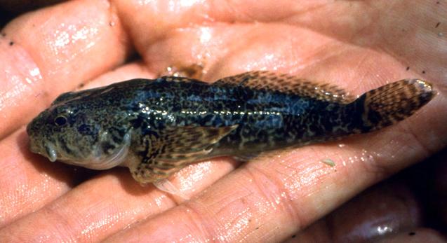
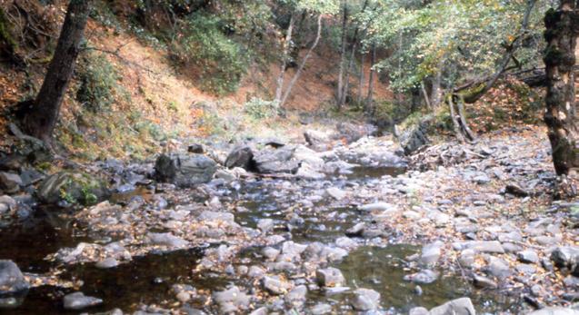
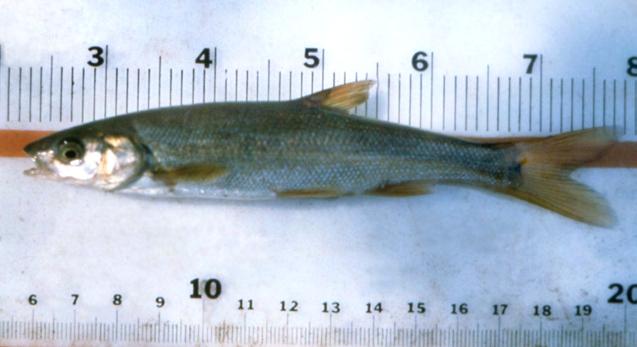
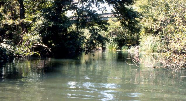
198
APPENDIX A bay pipefish Sygnathus leptorhynchus California halibut Paralichthys californicus Chinook salmon Oncorhynchus tshawytscha
 APPENDIX A Total number of fishes caught in Marsh by otter trawl, beach seine, midwater trawl, and all methods from 1979 to 2013 (native species in bold). Common Name Scientific Name Otter Trawl Beach
The full version of Appendix II is available at
 R. A. L E IDY 183 APPENDIX II Historical References for Native Stream Fishes for the Period 1854-1981, San Francisco Estuary, California The full version of Appendix II is available at www.sfei.org/leidy_no530/index.html
Appendix L Fish Habitat Assemblage Data
 Appendix L Fish Habitat Assemblage Data Appendix L Fish Habitat Assemblage Data Introduction The following section details the native and nonnative fish assemblages and instream aquatic habitat types
Survey of the Fish Populations of the Lower Cosumnes River. Amy Harris
 Survey of the Fish Populations of the Lower Cosumnes River Amy Harris Spring, 1996 1 I. Introduction The information that is available on the fish communities of the Cosumnes river consists primarily of
Salmon and Steelhead in the American River Tim Horner, PhD Geology Department California State University, Sacramento
 Salmon and Steelhead in the American River Tim Horner, PhD Geology Department California State University, Sacramento What kind of fish are in the American River? The American River provides habitat for
State of San Francisco Bay 2011 Appendix O Steelhead Trout Production as an Indicator of Watershed Health
 State of San Francisco Bay 2011 Appendix O Steelhead Trout Production as an Indicator of Watershed Health Gordon Becker and Katherine Smetak, Center for Ecosystem Management and Restoration 290 Introduction
Cache Creek Fisheries Survey 2008 Technical Report
 Cache Creek Fisheries Survey 2008 Technical Report Prepared for Yolo County Flood Control & Water Conservation District 34274 State Highway 16 Woodland, CA 95695 Prepared by Stillwater Sciences 279 Cousteau
WFC 50 California s Wild Vertebrates Jan. 11, Inland Waters (Lakes and Streams) Lisa Thompson
 Lisa Thompson") Inland Waters: Lakes and Streams WFC 50 11 January 2011 Lisa Thompson Fisheries Extension Specialist Wildlife, Fish, & Conservation Biology Department University of California, Davis Take home messages
Inland Waters: Lakes and Streams WFC 50 11 January 2011 Lisa Thompson Fisheries Extension Specialist Wildlife, Fish, & Conservation Biology Department University of California, Davis Take home messages
5B. Management of invasive species in the Cosumnes and Mokelumne River Basins
 5B. Management of invasive species in the Cosumnes and Mokelumne River Basins Cosumnes River The Cosumnes River basin has a number of distinct habitat types that require different management strategies
Executive Summary. Map 1. The Santa Clara River watershed with topography.
 Santa Clara River Steelhead Trout: Assessment and Recovery Opportunities December 2005 Prepared By: Matt Stoecker and Elise Kelley, Ph.D. University of California, Santa Barbara Prepared For: The Santa
San Lorenzo Valley Water District, Watershed Management Plan, Final Version Part I: Existing Conditions Report
 LIST OF FIGURES Figure 1-1. Map of the San Lorenzo River watershed Figure 2-1. The Santa Cruz Mountains Bioregion Figure 2-2. Protected areas within the San Lorenzo River watershed Figure 2-3. Primary
AQUATIC CONSERVATION: MARINE AND FRESHWATER ECOSYSTEMS
 AQUATIC CONSERVATION: MARINE AND FRESHWATER ECOSYSTEMS Aquatic Conserv: Mar. Freshw. Ecosyst. 21: 472 483 (2011) Published online in Wiley Online Library (wileyonlinelibrary.com). DOI: 10.1002/aqc.1208
Chinook Salmon in Putah Creek, Spring, Report to Lower Putah Creek Coordinating Committee. K. M. Small, P. K. Crain and P. B.
 Chinook Salmon in Putah Creek, Spring, 2004 Report to Lower Putah Creek Coordinating Committee K. M. Small, P. K. Crain and P. B. Moyle 25 June 2004 2 Introduction: During the summer and fall months, fall
INTERNAL REPORT 34. Richard S. Wydoski. University of Washington, Seattle INTRODUCTION
 3i INTERNAL REPORT 34 CJJIiCKLIST OF FISHES IN THE LAK}i WASHINGTON DRAINAGE Richard S. Wydoski University of Washington, Seattle INTRODUCTION Table I has been modified from Ajwani's (1956). Scientific
Trip Report: Eagle Creek, Arizona
 Trip Report: Eagle Creek, Arizona 15-17 June 2009 Participants: Abraham Karam, Brian Kesner, and Mike Childs Native Fish Lab Marsh & Associates, LLC 5016 South Ash Avenue Suite 108 Tempe, Arizona 85282
Five Counties Salmonid Conservation Program - Fish Passage Design Workshop. February 2013
 Program - Aquatic Organisms and Stream Crossings Ecological Connectivity A watershed is a network of channels that drain a common boundary. Channel characteristics formed by interaction of precipitation,
APPENDIX D. California Department of Fish and Wildlife, California Natural Diversity Database, Special Animals List, Fisheries, September 2014
 APPENDIX D California Department of Fish and Wildlife, California Natural Diversity Database, Special Animals List, Fisheries, September 2014 PETROMYZONTIDAE (lampreys) +Entosphenus hubbsi Kern brook
Beaver in tidal marshes: Dam effects on low-tide channel pools and fish use of estuarine habitat. W. Gregory Hood Skagit River System Cooperative
 Beaver in tidal marshes: Dam effects on low-tide channel pools and fish use of estuarine habitat W. Gregory Hood Skagit River System Cooperative Skagit Historical and Current Deltas 95% loss of tidal
APPENDIX G FISHERIES RESOURCES OF THE LOWER PAJARO RIVER AND ITS TRIBUTARIES
 FISHERIES RESOURCES OF THE LOWER PAJARO RIVER AND ITS TRIBUTARIES Pajaro Valley Water Management Agency G-1 Revised BMP Draft EIS FISHERIES RESOURCES OF THE LOWER PAJARO RIVER AND ITS TRIBUTARIES Prepared
Evaluation of Fisheries Relating to Floodplain Restoration on the Cosumnes River Preserve 1. Prepared by. Keith Whitener 2 Trevor Kennedy
 Evaluation of Fisheries Relating to Floodplain Restoration on the Cosumnes River Preserve 1 Introduction Prepared by Keith Whitener 2 Trevor Kennedy 3 1998 The continuous worldwide alteration and degradation
Data Report : Russian River Basin Steelhead and Coho Salmon Monitoring Program Pilot Study
 Data Report 1999-1: Russian River Basin Steelhead and Coho Salmon Monitoring Program Pilot Study Sonoma County Water Agency 215 West College Avenue Santa Rosa, California 951 Prepared by David Cook Senior
Thunder Bay River Assessment Appendix. Appendix 2
 Appendix 2 Known past and present fish distributions in the River system. Distribution of fishes were compiled from Bailey et al. (2003) and from records located at the Michigan Department of Natural Resources
FISHERIES BLUE MOUNTAINS ADAPTATION PARTNERSHIP
 FISHERIES A warming climate, by itself, substantially affects the hydrology of watersheds in the Blue Mountains. Among the key hydrologic changes projected under all scenarios for the 2040s and beyond
Cemetery Creek Smolt Trap Data Summary What is a smolt? What is a smolt trap? Cemetery Creek Smolt Trap Data:
 Cemetery Creek Smolt Trap Data Summary What is a smolt? A "smolt" is one of the life stages of a juvenile salmon. This life stage occurs when the juvenile salmon begins its migration from freshwater to
State of California Department of Fish and Wildlife Clear Lake Fishery and Habitat Evaluation
 State of California Department of Fish and Wildlife 2014-2015 Clear Lake Fishery and Habitat Evaluation Ben Ewing, Kassie Hickey, and Jay Rowan North Central Region High Elevation Fisheries February 17,
California Steelhead: Management, Monitoring and Recovery Efforts
 California Steelhead: Management, Monitoring and Recovery Efforts Jonathan Nelson Steelhead Restoration & Management Program Oncorhynchus mykiss irideus California Steelhead Distinct Population Segments
NAPA RIVER STEELHEAD AND SALMON SMOLT MONITORING PROGRAM
 NAPA RIVER STEELHEAD AND SALMON SMOLT MONITORING PROGRAM ANNUAL REPORT YEAR 1 JULY, 2009 NAPA COUNTY RESOURCE CONSERVATION DISTRICT CONTACT: JONATHAN KOEHLER SENIOR BIOLOGIST (707) 252 4188 X 109 JONATHAN@NAPARCD.ORG
Proposed Reclassification of Cherry Creek, North Platte River Basin, Wyoming. October 25, 2010
 Proposed Reclassification of Cherry Creek, North Platte River Basin, Wyoming October 25, 2010 Waterbody: Location: Tributary to: Cherry Creek - Mainstem from headwaters downstream to the confluence with
APPENDIX L Species Composition of Fish, Shrimp, and Crabs Collected by the California Department of Fish and Game Fishery Surveys from South Bay
 APPENDIX L Species Composition of Fish, Shrimp, and Crabs Collected by the California Department of Fish and Game Fishery Surveys from South Bay Introduction California Department of Fish and Game (Baxter
Regulatory Language Sunfish. Includes bluegill, green sunfish, redear sunfish, pumpkinseed, warmouth, yellow perch and Sacramento perch.
 Regulatory Language Section 1.45, Title 14, CCR, is added as follows: 1.45, Filleting of Salmonids in Inland Waters. Except as otherwise required, all salmon and steelhead taken in inland waters where
APPENDIX A. JSA Report: Use of Floodplain Habitat of the Sacramento and American Rivers by Juvenile Chinook Salmon and Other Fish Species
 APPENDIX A JSA Report: Use of Floodplain Habitat of the Sacramento and American Rivers by Juvenile Chinook Salmon and Other Fish Species Use of Floodplain Habitat of the Sacramento and American Rivers
Historical Distribution and Current Status of Steelhead/Rainbow Trout (Oncorhynchus mykiss) in Streams of the San Francisco Estuary, California
 in Streams of the San Francisco Estuary, California") Historical Distribution and Current Status of Steelhead/Rainbow Trout (Oncorhynchus mykiss) in Streams of the San Francisco Estuary, California Robert A. Leidy, Environmental Protection Agency, San Francisco,
Historical Distribution and Current Status of Steelhead/Rainbow Trout (Oncorhynchus mykiss) in Streams of the San Francisco Estuary, California Robert A. Leidy, Environmental Protection Agency, San Francisco,
NORTHERN SANTA CLARA COUNTY FISH RESOURCES. Jerry J. Smith Department of Biological Sciences San Jose State University San Jose, CA July 2013
 NORTHERN SANTA CLARA COUNTY FISH RESOURCES Jerry J. Smith Department of Biological Sciences San Jose State University San Jose, CA 95132 25 July 2013 INTRODUCTION Steelhead (Oncorhynchus mykiss) originally
THE UC DAVIS BIOSENTINEL MERCURY MONITORING PROGRAM: Feedback Tool for Watershed Management
 THE UC DAVIS BIOSENTINEL MERCURY MONITORING PROGRAM: Feedback Tool for Watershed Management Darell G. Slotton Shaun M. Ayers Ronald D. Weyand Department of Environmental Science and Policy University of
Abundance of Steelhead and Coho Salmon in the Lagunitas Creek Drainage, Marin County, California
 scanned for KRIS Abundance of Steelhead and Coho Salmon in the Lagunitas Creek Drainage, Marin County, California Prepared for: Marin Municipal Water District 220 Nellen Drive Corte Madera, California
Fish Survey of Arctic Lake (ID # ), Scott County, Minnesota in 2012
, Scott County, Minnesota in 2012") Snapping Turtle from Arctic Lake, September 2012 Fish Survey of Arctic Lake (ID #70-0085), Scott County, Minnesota in 2012 Survey Dates: September 18-20, 2012 MnDNR Permit Number: 18362 Prepared for: Shakopee
Snapping Turtle from Arctic Lake, September 2012 Fish Survey of Arctic Lake (ID #70-0085), Scott County, Minnesota in 2012 Survey Dates: September 18-20, 2012 MnDNR Permit Number: 18362 Prepared for: Shakopee
DRAFT TECHNICAL MEMORANDUM
 DRAFT TECHNICAL MEMORANDUM From: File No.: 213.001 Re: Beaux Arts Village Shoreline - 2016 Introduction The Washington Academy of Beaux Arts (WABA) completed shoreline habitat restoration at three locations
Napa River Steelhead and Salmon Monitoring Program Report
 Napa River Steelhead and Salmon Monitoring Program 2017-18 Report November 2018 Prepared by: Jonathan Koehler and Paul Blank Napa County Resource Conservation District 1303 Jefferson St. Suite 500B Napa,
Searsville Dam Removal
 Searsville Dam Removal A unique opportunity for all Presented by the Beyond Searsville Dam Coalition San Francisquito Creek flows into the San Francisco Bay near the Palo Alto Airport and Golf Course seen
Rouge Fish Surveys
 Rouge Fish Surveys 2011-16 Friends of the Rouge January 2017 Partially funded by the Areas of Concern Program Office of the Great Lakes (OGL), DEQ Additional data provided by MDNR and MDEQ Fall 2016 Sampling
2016 and 2017 Fish Assemblage Report For the Guadalupe River Watershed Mercury Total Maximum Daily Load
 2016 and 2017 Fish Assemblage Report For the Guadalupe River Watershed Mercury Total Maximum Daily Load Santa Clara Valley Water District 5750 Almaden Expressway San Jose, CA 95118 February 7, 2017 i Contents
Application of IP Models for Salmon and Steelhead Recovery Planning in California
 Application of IP Models for Salmon and Steelhead Recovery Planning in California Brian Spence and David Boughton NMFS Southwest Fisheries Science Center Uses of IP models in technical recovery planning
California Steelhead: Management, Monitoring and Recovery Efforts
 California Steelhead: Management, Monitoring and Recovery Efforts Jonathan Nelson Steelhead Management, Research and Restoration Program Oncorhynchus mykiss irideus California Steelhead - Hot Topics Implementation
STREAM SURVEY File form No..
 scanned for KRIS THE RESOURCES AGENCY OF CALIFORNIA California Department of Fish and Game STREAM SURVEY File form No.. Date: September 4, 1969. NAME: North Fork Schooner Gulch Creek COUNTY: Mendocino.
Columbia Lake Dam Removal Project
 Columbia Lake Dam Removal Project The Columbia Lake dam located 1/4 mile upstream of the Paulins Kill River's confluence with the Delaware River in Knowlton Township, Warren County has been proposed for
Lower Dolores River Corridor Planning Meeting Jim White Colorado Division of Wildlife
 Lower Dolores River Corridor Planning Meeting Jim White Colorado Division of Wildlife Objectives Overview of cold and warm water fishes in the Dolores River including: Flow and Fish Management Distribution
Student Worksheet: River Health and Indicator Species
 1 Student Worksheet: River Health and Indicator Species Mink frogs (Lithobates septentrionalis). Credit: Allan G. Austin Activity 1: Biodiversity and Indicator Species Watch the videothe Importance of
Parasitic Copepods (Salmincola sp.) and Fish Species Composition in Upper Willamette Reservoirs
 and Fish Species Composition in Upper Willamette Reservoirs") Parasitic Copepods (Salmincola sp.) and Fish Species Composition in Upper Willamette Reservoirs Jeremy D. Romer* Ryan Emig* Fred R. Monzyk Oregon Department of Fish and Wildlife Corvallis Research Lab
Parasitic Copepods (Salmincola sp.) and Fish Species Composition in Upper Willamette Reservoirs Jeremy D. Romer* Ryan Emig* Fred R. Monzyk Oregon Department of Fish and Wildlife Corvallis Research Lab
Proposed Reclassification of Deer Creek, North Platte River Basin, Wyoming
 Proposed Reclassification of Deer Creek, North Platte River Basin, Wyoming October 25, 2010 Waterbody: Location: Tributary to: Deer Creek - Mainstem from headwaters downstream to the confluence with the
LOWER MOKELUMNE RIVER UPSTREAM FISH MIGRATION MONITORING Conducted at Woodbridge Irrigation District Dam August 2014 through July 2015.
 LOWER MOKELUMNE RIVER UPSTREAM FISH MIGRATION MONITORING Conducted at Woodbridge Irrigation District Dam August 2014 through July 2015 August 2015 Casey Del Real and Matt Saldate East Bay Municipal Utility
3.3.3 Aquatic Resources
 3.3.3 Aquatic Resources The discussion of aquatic resources is divided into five sections. The affected environment is discussed in Section 3.3.3.1 and the environmental effects of the Project are discussed
Summer Steelhead Surveys North Fork Trinity River Trinity County, California
 KRIS edition Summer Steelhead Surveys North Fork Trinity River Trinity County, California 1978-1997 By Loren Everest Fishery Biologist Weaverville Ranger District Shasta-Trinity National Forests October
Final Report August 2005
 2.0 REGIONAL STUDY AREA 2.1 Regional Setting 2.1.1 Topography The Los Angeles Region is located within the western portion of the Transverse Ranges Geomorphic Province. The San Andreas transform fault
A PROGRESS REPORT ON THE RUSSIAN RIVER FISH POPULATION STUDY: /
 A PROGRESS REPORT ON THE RUSSIAN RIVER FISH POPULATION STUDY: 1954-1956 1/ WILLIAM C. JOHNSON Region 3, Inland Fisheries Branch California Department of Fish and Game INTRODUCTION This report is part of
STEELHEAD SURVEYS IN OMAK CREEK
 STEELHEAD SURVEYS IN OMAK CREEK 2002 Annual Report Prepared by Chris Fisher John Arterburn Colville Confederated Tribes Fish and Wildlife Department P.O. Box 150 Nespelem, WA 99155 Prepared for Project
Extant and Extirpated Native Fishes of Aravaipa Creek (Stefferud and Reinthal 2004)
") Aravaipa Creek REMNANT NATIVE FISH COMMUNITIES IN THE GILA RIVER BASIN RETAINING FIVE OR MORE NATIVE SPECIES (not including species extirpated and then reintroduced) STREAM NO. OF NATIVE FISH SPECIES REMAINING
Aravaipa Creek REMNANT NATIVE FISH COMMUNITIES IN THE GILA RIVER BASIN RETAINING FIVE OR MORE NATIVE SPECIES (not including species extirpated and then reintroduced) STREAM NO. OF NATIVE FISH SPECIES REMAINING
MINNESOTA DEPARTMENT OF NATURAL RESOURCES DIVISION OF FISHERIES AND WILDLIFE. Gamefish Assessment Report
 Minnesota DNR F-29-R(P) Area F312 February 1, 2013 MINNESOTA DEPARTMENT OF NATURAL RESOURCES DIVISION OF FISHERIES AND WILDLIFE Gamefish Assessment Report Spring Gamefish Assessment on the Mississippi
Potlatch River Drainage: Salmonid Presence: Largest lower Clearwater River tributary
 X Y Potlatch River Drainage: Largest lower Clearwater River tributary Area = 1500 km 2 Mouth ~ 13 km upstream of Snake/Clearwater confluence X Y Dominated by private land Salmonid Presence: Steelhead,
Freshwater Fish Assessment
 Alaska Department of Transportation & Public Facilities Seward Highway MP 7-9 6-7 Freshwater Fish Assessment March 14, 8 Prepared by HDR Alaska C Street, Suite 3 Anchorage, Alaska 993 Project Number: BR-BH-NH-OA3
Alberta Conservation Association 2017/18 Project Summary Report
 Alberta Conservation Association 2017/18 Project Summary Report Project Name: Abundance, Distribution, Spawning, and Thermal Habitat of Westslope Cutthroat Trout and Bull Trout in the Stimson Creek Watershed
STUDY PERFORMANCE REPORT
 STUDY PERFORMANCE REPORT State: Michigan Project No.: F-81-R-6 Study No.: 230695 Title: Northern Lake Huron, coolwater fish community assessment. Period Covered: October 1, 2004 to September 30, 2005 Study
A.23 RIVER LAMPREY (LAMPETRA
 A. RIVER LAMPREY (LAMPETRA AYRESII) A.. Legal and Other Status The river lamprey is a Class (Watch List) California Species of Special Concern (Moyle et al., DFG 0). It has no federal status. A.. Species
CHAPTER 4 DESIRED OUTCOMES: VISION, GOALS, AND OBJECTIVES
 CHAPTER 4 DESIRED OUTCOMES: VISION, GOALS, AND OBJECTIVES Vision One of the first steps in developing this Plan was articulating a vision - a clear statement of what the Plan strives to achieve and what
NEVADA DEPARTMENT OF WILDLIFE STATEWIDE FISHERIES MANAGEMENT
 NEVADA DEPARTMENT OF WILDLIFE STATEWIDE FISHERIES MANAGEMENT FEDERAL AID JOB PROGRESS REPORTS F-20-52 2016 Lake Tahoe Rainbow Trout Study WESTERN REGION NEVADA DEPARTMENT OF WILDLIFE, FISHERIES DIVISION
Great Lakes Coastal Wetland Communities: Vulnerabilities to Climate Change and Response to Adaptation Strategies
 Great Lakes Coastal Wetland Communities: Vulnerabilities to Climate Change and Response to Adaptation Strategies CCAF Wetlands Study Investigators: Susan Doka Fisheries & Oceans, Great Lakes Lab for Fisheries
The relationship between the spatial distribution of common carp and their environmental DNA in a small lake
 The relationship between the spatial distribution of common carp and their environmental DNA in a small lake Jessica Eichmiller*, Przemyslaw Bajer, and Peter Sorensen Department of Fisheries, Wildlife,
Study Update Tailrace Slough Use by Anadromous Salmonids
 Study Update Tailrace Slough Use by Anadromous Salmonids Goals and Objectives Identify what anadromous salmonids use the tailrace slough by: Life Stage (Juvenile, migrating and spawning adults) Timing
NAPA RIVER STEELHEAD AND SALMON SMOLT MONITORING PROGRAM
 NAPA RIVER STEELHEAD AND SALMON SMOLT MONITORING PROGRAM ANNUAL REPORT YEAR 2 AUGUST, 2010 NAPA COUNTY RESOURCE CONSERVATION DISTRICT JONATHAN KOEHLER PAUL BLANK SENIOR BIOLOGIST HYDROLOGIST (707) 252
CHINOOK SALMON SACRAMENTO RIVER WINTER-RUN ESU, CENTRAL VALLEY SPRING-RUN ESU, AND CENTRAL VALLEY FALL AND LATE FALL-RUN ESU
 CHINOOK SALMON SACRAMENTO RIVER WINTER-RUN ESU, CENTRAL VALLEY SPRING-RUN ESU, AND CENTRAL VALLEY FALL AND LATE FALL-RUN ESU Oncorhynchus tshawytscha USFWS: Endangered (Winter); Threatened (Spring); Candidate
AQUATIC LIFE SURVEY RESULTS
 SANTA ROSA SUBREGIONAL LONG-TERM WASTEWATER PROJECT Prepared for City of Santa Rosa and U.S. Army Corps of Engineers April 1996 Prepared by Merritt Smith Consulting Environmental Science and Communication
ADOPTED REGULATION OF THE BOARD OF WILDLIFE COMMISSIONERS. LCB File No. R Effective December 6, 2001
 ADOPTED REGULATION OF THE BOARD OF WILDLIFE COMMISSIONERS LCB File No. R104-01 Effective December 6, 2001 EXPLANATION Matter in italics is new; matter in brackets [omitted material] is material to be omitted.
X.B WETLANDS ROGUE RIVER ESTUARY
 X.B WETLANDS ROGUE RIVER ESTUARY The Rogue River has a drainage area of 5,100 square miles, yet the estuary of the Rogue River is one of the smallest in Oregon, measuring approximately 1,880 acres during
EXTENT OF OBSERVATION
 scanned for KRIS THE RESOURCES AGENCY OF CALIFORNIA Department of Fish and Game STREAM SURVEY Date: May 25 and 31, 1977. NAME: Unnamed Stream (Tributary to Sonoma Creek) COUNTY: Sonoma. STREAM SECTION:
Range on private land in proposed priority area (%) Fish Rhinichthys osculus nevadensis Amargosa Canyon Speckled 50,
 Fish Rhinichthys osculus nevadensis Amargosa Canyon Speckled 50,") Table S1. Target taxa, summary mapped and observational range information, and percent of those ranges included in existing Class 1,2 protected areas and proposed priority conservation areas. Group Scientific
Table S1. Target taxa, summary mapped and observational range information, and percent of those ranges included in existing Class 1,2 protected areas and proposed priority conservation areas. Group Scientific
BA1 BA2 BA3 BA4 BA5 BA6 CP1 CP2 CP3 CP4 CP5 CP6
 Table 1: Results of fish collections within or adjacent to the Boyne Secondary Plan Area conducted by C. Portt and Associates. Station locations are provided in Figure 1. Stations BA1-BA6 were collected
Bonita Creek Fish Monitoring November 4 6, 2015
 Bonita Creek Fish Monitoring November 4 6, 2015 Brittany M. Woodward, Kristen G. Humphrey, and Brian R. Kesner Marsh & Associates, LLC 5016 S. Ash Avenue, Suite 108 Tempe, Arizona 85282 Submitted to Bureau
Cold-transitional Stream
 Cold-transitional Stream A Brief Ecological Description of this Michigan River Type Cold-transitional Stream segments are defined (by the Michigan Department of Natural Resources, Fisheries Division) as
Quarry Lakes Fisheries Report EBRPD Fisheries Department. Joe Sullivan Fisheries Resource Analyst Peter Alexander Fisheries Program Manager
 Quarry Lakes Fisheries Report 2011 EBRPD Fisheries Department Joe Sullivan Fisheries Resource Analyst Peter Alexander Fisheries Program Manager Introduction The purpose of this report is to give lake supervisors
1998 Willow Creek Downstream Migrant Trap Report. Draft. Prepared By: C. A. Walker. Lower Trinity Ranger District. Six Rivers National Forest
 1998 Willow Creek Downstream Migrant Trap Report Draft Prepared By: C. A. Walker Lower Trinity Ranger District Six Rivers National Forest September 1998 Executive Summary The downstream migrant trap was
NEVADA DEPARTMENT OF WILDLIFE STATEWIDE FISHERIES MANAGEMENT
 NEVADA DEPARTMENT OF WILDLIFE STATEWIDE FISHERIES MANAGEMENT FEDERAL AID JOB PROGRESS REPORTS F-20-52 2016 REDBAND TROUT EASTERN REGION NEVADA DEPARTMENT OF WILDLIFE, FISHERIES DIVISION ANNUAL JOB PROGRESS
Restoring native fish assemblages to a regulated California stream using the natural flow regime concept
 Ecological Applications, 22(5), 2012, pp. 1472 1482 Ó 2012 by the Ecological Society of America Restoring native fish assemblages to a regulated California stream using the natural flow regime concept
Chinook Salmon Spawning Study Russian River Fall 2005
 Chinook Salmon Spawning Study Russian River Fall 2005 Sonoma County Water Agency 2150 West College Avenue Santa Rosa, California 95401 Prepared by David Cook - Senior Environmental Specialist March 27,
1165 S Hwy 191, Suite S 2350 W Moab, UT Vernal, UT
 COLORADO RIVER RECOVERY PROGRAM FY 2018 ANNUAL PROJECT REPORT RECOVERY PROGRAM PROJECT NUMBER: C29a/138 I. Project Title: Green River Canal Company (GRCC) Canal Salvage II. Bureau of Reclamation Agreement
Warm-up # 7 A day 5/17 - B day 5/18 UPDATE YOUR TABLE OF CONTENTS
 Warm-up # 7 A day 5/17 - B day 5/18 UPDATE YOUR TABLE OF CONTENTS Question: List all examples of surface water on Earth. Answer: Rivers and streams, lakes and reservoirs, (ponds) wetlands, estuaries and
Ecosystem Monitoring Project 2014 Fish Sampling Update
 Ecosystem Monitoring Project 2014 Fish Sampling Update Lyndal Johnson, Sean Sol, Dan Lomax, Paul Chittaro, David Teel, and Gina Ylitalo NOAA Fisheries Northwest Fisheries Science Center, Seattle, WA, USA
Walker Creek Salmon Monitoring Program FINAL COMPILATION REPORT
 FINAL COMPILATION REPORT Submitted to: California Department of Fish and Game Fishery Restoration Grant Program Grant No. P053414 Submitted by: Marin Municipal Water District (MMWD) 220 Nellen Avenue Corte
Little Calumet River Rapid Response Fish Identification and Enumeration Branch Summary Report
 Little Calumet River Rapid Response Fish Identification and Enumeration Branch Summary Report Introduction A rotenone rapid response was completed on a 2.6-mile section of the Little Calumet River immediately
CHAPTER 2 - THE COQUILLE FISHERY
 CHAPTER 2 - THE COQUILLE FISHERY TABLE OF CONTENTS A. INTRODUCTION... 2-1 FIGURE 2-1 Life Histories of Anadromous Salmonids in the Coquille River... 2-2 1. Coho Salmon... 2-2 FIGURE 2-2 Coho Packed or
WFC 10 Wildlife Ecology & Conservation Nov. 29, Restoration Ecology: Rivers & Streams. Lisa Thompson. UC Cooperative Extension
 Restoration Ecology: Rivers and Streams WFC 10 29 Nov 2010 Restoration of ecosystems often involves creating new systems with only partial resemblance to the original ecosystems Lisa Thompson Fisheries
Minnesota Department of Natural Resources Division of Fish and Wildlife Section of Fisheries. Stream Survey Report. Cold Spring Creek.
 Minnesota F-29-R(P)-24 Area 315 Study 3 March 2015 Minnesota Department of Natural Resources Division of Fish and Wildlife Section of Fisheries Stream Survey Report Cold Spring Creek 2014 Mark Pelham Montrose
Steelhead Spawning Ground Surveys on the Entiat River, 2015.
 Steelhead Spawning Ground Surveys on the Entiat River, 2015. Kenneth Poczekaj and R.D. Nelle U.S. Fish and Wildlife Service Mid-Columbia River Fishery Resource Office Leavenworth, WA 98826 On the cover:
Fish monitoring requirements of new FERC licenses: are they adequate?
 Fish monitoring requirements of new FERC licenses: are they adequate? Joseph D. Kiernan, Peter B. Moyle and John G. Williams Center for Watershed Sciences University of California, Davis Trends from recently
Warner Lakes Redband Trout
 Warner Lakes Redband Trout Existing Populations Warner Valley is an endorheic basin that contains a complex series of interconnected lakes, marshes, sloughs, and potholes, all of which are remnants of
Annex B SUPPLEMENTAL INFORMATION. Table of Contents. Scientific Names of Select Plants and Animals. Fish species collected in Curwensville Lake
 Annex B SUPPLEMENTAL INFORMATION Table of Contents Scientific Names of Select Plants and Animals Fish species collected in Curwensville Lake Alternative Plans Percentage of Future Years with Drawdowns
Mercury Concentrations in Fishes from Select Water Bodies in Trinity County, California,
 University of Nebraska - Lincoln DigitalCommons@University of Nebraska - Lincoln Publications of the US Geological Survey US Geological Survey 2005 Mercury Concentrations in Fishes from Select Water Bodies
Annotated Checklist of the Fishes of the Rio Grande Drainage, Dona Ana, El Paso, and Hudspeth Counties
 Annotated Checklist of the Fishes of the Rio Grande Drainage, Dona Ana, El Paso, and Hudspeth Counties Laboratory for Environmental Biology, Centennial Museum, University of Texas at El Paso An Informal,
RESULTS OF THE SONOMA COUNTY WATER AGENCY'S MIRABEL RUBBER DAM/WOHLER POOL RECONNAISSANCE FISH SAMPLING PROGRAM 1999
 RESULTS OF THE SONOMA COUNTY WATER AGENCY'S MIRABEL RUBBER DAM/WOHLER POOL RECONNAISSANCE FISH SAMPLING PROGRAM 1999 October 1, 2000 Prepared by Shawn Chase Ron Benkert David Manning Sean White Steve Brady
Tuolumne River Gravel Introduction
 Tuolumne River Gravel Introduction 2000 2003 Tuolumne River La Grange Gravel Addition, Phase II Course Sediment Replenishment Program Tuolumne River Salmonid Habitat Improvement Project River Mile 49.9
Bonita Creek Fish Monitoring September 29 October 2, 2015
 Bonita Creek Fish Monitoring September 29 October 2, 2015 Brittany M. Woodward, Kristen G. Humphrey, and Brian R. Kesner Marsh & Associates, LLC 5016 S. Ash Avenue, Suite 108 Tempe, Arizona 85282 Submitted
Maryland Chapter Trout Unlimited Brook Trout Conservation Effort
 Maryland Chapter Trout Unlimited Brook Trout Conservation Effort Photo by Matt Kline Portfolio of Recent Work MDTU Brook Trout Conservation Coordinator: Scott C. Scarfone, ASLA sscarfone@oasisdesigngroup.com