River Crane and Duke of Northumberland s River Fisheries Impact Assessment Pollution Incident 2011
|
|
|
- Eugenia Watkins
- 6 years ago
- Views:
Transcription


1 River Crane and Duke of Northumberland s River Fisheries Impact Assessment Pollution Incident 2011 Neil Winter, Technical Officer- Fisheries December 2013
2 Page left blank intentionally 2
3 Table of Contents Page Table of Contents 3 List of Figures 4 List of Tables 5 1. Aims and Objectives 6 2. Description of Watercourse Pollution Incident 6 3. Assessment of the Fish Population Background to Fish Surveys Survey / Capture Technique 8 4. Results Cranford Park Hounslow Heath Crane Park Island Results Discussion - Fish population 23 & impact assessment 4.5. Impact assessment summary Discussion and recommendations Restoring a fish population Fisheries habitat improvement In-channel habitat improvements Backwater and bay creation Marginal aquatic vegetation habitat creation Fish migration and easement Summary of recommendations for recovery 40 of the fish population References 42 Appendix 1: Fish Carcass Data 41 Appendix 2: Fish species and their sexual maturity 43 Appendix 3: Environment Agency Document 44 - Fish Restocking Strategy Appendix 4: Cranford Park Fish Density 49 Appendix 5: Hounslow Heath Fish Density 52 Appendix 6: Crane Park Fish Density 54 Appendix 7: Combined River Crane estimated species 59 contribution to fish density, based on combined fish survey data between 2000 to 2010 Appendix 8: The Water Framework Directive 60 3
4 List of Figures Page Figure 1: Map of River Crane pollution discharge 7 location downstream to confluence with the River Thames Figure 2: Map of the three fish survey site locations 10 on the River Crane Figure 3: Cranford Park fish species biomass comparison to 2012 Figure 4: Hounslow Heath fish species biomass 18 comparison 2005 to 2012 Figure 5: Crane Park Island fish species biomass comparison to 2012 Figure 6: Map showing the Yeading Brook confluence with 29 the River Crane Figure 7: Map of the Duke of Northumberland s River 30 confluence with the River Crane. Figure 8: Estimated combined percentage species 33 contribution to fish density in the River Crane between 2000 and Figure 9: Map of River Crane & Duke of Northumberland s 38 River structure locations Figure 10: Estimated percentage species contribution to 52 fish density at Cranford Park 2000 Figure 11: Estimated percentage species contribution to fish 52 density at Cranford Park 2005 Figure 12: Estimated percentage species contribution to fish 53 density at Cranford Park 2010 Figure 13: Estimated mean percentage species contribution 53 to fish density at Cranford Park based on data from 2000, 2005 and 2010 combined. Figure 14: Estimated percentage species contribution to 54 fish density at Hounslow Heath 2005 Figure 15: Estimated percentage species contribution to 55 fish density at Hounslow Heath 2010 Figure 16: Estimated mean percentage species contribution 55 to fish density at Hounslow Heath based on data from 2005 and 2010 combined. Figure 17: Estimated percentage species contribution to fish 57 density at Crane Park Figure 18: Estimated percentage species contribution to fish 58 density at Crane Park 2005 Figure 19: Estimated percentage species contribution to fish 59 density at Crane Park 2010 Figure 20: Estimated mean percentage contribution of species 60 to fish density at Crane Park based on data from 2000, 2005 and 2010 combined. 4
5 List of Tables Page Table 1a: 2000 fishery survey results at 11 Cranford Park, River Crane Table 1b: 2005 fishery survey results at 12 Cranford Park, River Crane Table 1c: 2010 fishery survey results at 12 Cranford Park, River Crane Table 1d: 2011 post pollution fishery survey 13 results at Cranford Park, River Crane Table 1e: 2012 post pollution fishery survey results 13 at Cranford Park, River Crane Table 2a: 2005 fishery survey results at 15 Hounslow Heath, River Crane Table 2b: 2010 fishery survey results at 16 Hounslow Heath, River Crane Table 2c: 2011 post pollution fishery survey results 16 at Hounslow Heath, River Crane Table 2d: 2012 post pollution fishery survey results 17 at Hounslow Heath, River Crane Table 3a: 2000 fishery survey results at 19 Crane Park, River Crane Island Table 3b: 2005 fishery survey results at 19 Crane Park, River Crane Island Table 3c: 2010 fishery survey results at 20 Crane Park, River Crane Island Table 3d: 2011 post pollution fishery survey results 20 at Crane Park, River Crane Island Table 3e: 2012 fishery survey results at 21 Crane Park, River Crane Island Table 4: Ammonia results taken by Environment Officers 25 throughout the River Crane on 30 th October Table 5: Species and size ranges recommended for stocking 32 5
6 1. Aims and Objectives This document outlines the impact of the pollution event of 29 th October 2011 that occurred on the River Crane and Duke of Northumberland s River with the following aims and objectives: i. To assess the pre pollution fish population of the affected stretch of river. ii. To assess the post pollution fish population within the affected stretch of river. iii. To discuss the impact of the pollution on fish populations. iv. To assess the requirements needed to restore fish populations within the affected stretches of river v. To produce a report suitable for use by the courts system 2. Description of Watercourse The River Crane is located in the west of London, rising as the Yeading Brook in west Harrow and flowing south through the London Boroughs of Hillingdon, Ealing, Hounslow and Richmond before entering the River Thames at Isleworth. The main tributaries are the East and West arms of Yeading Brook and the artificial Duke of Northumberland s river which also connects the Crane to the Colne catchment. The catchment drains an area of approximately 100km 2 and comprises approximately 40km of river channel. Much of the River Crane has been modified and the catchment includes industrial sites, notably Heathrow Airport, transport links, such as the M4, M40 motorways and mainline rail services, and large areas of urban and suburban development. Despite the urban nature of the catchment the river corridor does contain sizeable stretches of green land and also some areas of conservation value, like Ickenham Marsh, Yeading Meadows, Hounslow Heath and Crane Park. The River Crane is the most important part of the West London Green Chain, which follows 30km of the river and is considered an important wildlife corridor for London. The geology of the catchment is for the most part London Clay, which is largely impermeable to water infiltration and thickens towards the downstream end of the catchment. Many invasive non-native species are present in the Crane catchment, including Signal crayfish Pollution Incident On October 29 th 2011 a large quantity of sewage entered the River Crane just near the A4 road at National Grid Reference TQ This is confirmed in the witness statements of Environment Agency staff Peter John Rudd, Senior Environment Officer and Peter Kirton, Environment Officer. I was also the first Fisheries Officer at site on Sunday 30 th October and based on my own observations (and stated within my witness statement) that the sewage discharge was impacting on the River Crane and killing fish at the time. The discharge of sewage had an impact on the river from the A4 road 6
 was also impacted from this point down to it s confluence")
7 downstream to the confluence with the River Thames. In addition, the Duke of Northumberland s River (connected with the River Crane near Mereway Road at National Grid Reference TQ ) was also impacted from this point down to it s confluence with the River Thames. The impact on this section of the Duke of Northumberland s River is confirmed within the witness statement of Robert Pearson, Environment Agency Fisheries Officer who observed dead fish throughout. In total an approximate length of 15km of river suffered an impact from this pollution incident. See figure 1 below. Figure 1: Map of River Crane pollution discharge location downstream to confluence with the River Thames. Crown Copyright and database right
8 3. Assessment of the fish population Dead fish were collected from Monday 1 st November 2011 until Friday 5 th November throughout the impacted stretch of both rivers and a fish carcass count was conducted. This looked at fish species, numbers and size ranges. This allowed a minimum total carcass count to be established. Post pollution fish surveys were then conducted on 17 th November 2011 and 12 th August 2012 by Environment Agency staff. The results of these surveys are discussed within this document. Environment Agency staff teams conducting the surveys were as follows: 17 th November 2011 Neil Winter Technical Officer- Fisheries Alex Deacon Environmental Monitoring Officer (Sampling & Collection) Adam Ellis Environmental Monitoring Officer (Sampling & Collection) Tom Grayling Environmental Monitoring Officer (Sampling & Collection) 12 th August 2012 Neil Winter Technical Officer- Fisheries Robert Pearson Technical Officer- Fisheries Adrian Bicknell Technical Officer Fisheries Tom Sale Environmental Monitoring Assistant (Sampling & Collection) Neale Hider Technical Officer Biodiversity (observing only) 3.1. Background to Fish Surveys Fish surveys were carried out in the year 2000, 2005 and 2010 as part of the Environment Agency s National Fisheries Monitoring Programme (NFMP) at three sites on the River Crane located at Cranford Park, Hounslow Heath (not surveyed in 2000) and Crane Park Island (See Figure 2). The results of these surveys provide a pre-pollution assessment of the fish populations in the River Crane at these three sites. They indicate that the River Crane supported a mixed coarse fishery which increased in both diversity and fish densities with its distance from the source of the river. Post-pollution surveys were carried out in November 2011 and August 2012 at the same locations as the previous years NFMP sites enabling close comparison of results Survey / Capture Technique Electric fishing is the most common method of monitoring fish in small and medium-sized rivers. All River Crane surveys pre- and post-pollution were conducted using this method of a three run catch depletion and is described as follows: Electric fishing works by immersing into the river one or more electrodes connected to a power source and control box. The electric field created stuns 8
9 the fish within the field and, by interfering with the fishes swimming muscles, draws the fish towards the centre of the electrode. They are then removed with hand nets from the water to be counted, measured, and in some cases weighed. A scale sample may be taken so that the age and growth history of the fish can be determined. To estimate the number, density and biomass of fish in a river, a reach is isolated using two stop nets (one upstream and one downstream) across the river. This prevents fish moving into or out of the survey section. Fishing the whole width of the river, working from the lower net to the upper net, fish are caught, counted, measured and then retained in suitable holding facilities until the survey is completed. The reach is fished once or twice more, and on each fishing run the catch is removed, processed and retained. From these results it is possible to calculate an estimate for the total number of fish within the section. After the survey is complete, all captured fish are returned alive to the survey site. Electric fishing is very effective and remains the most effective means of monitoring many river fisheries. 9

10 Figure 2: Map of the three fish survey site locations on the River Crane. Crown Copyright and database right
11 4. Results Below are the results of electric fishing surveys carried out over 100 metre long stretches of the River Crane between 2000 and 2010 by the Environment Agency Sampling and Collection Team and the Fisheries Department, based at the Hatfield Office. Post pollution survey results in both 2011 and 2012 used the exact survey sites, methodology and thus remained consistent. I was Lead Officer, directing the team, on all the post pollution surveys. The results are illustrated discussing numbers of fish found at each site for ease of comparison and additionally biomass to show the difference between pre pollution and post pollution surveys. Cranford Park survey site is upstream of the pollution entry and shows no direct impact due to the pollution. Therefore this site was used as a control for results comparison. Both Hounslow Heath and Crane Park Island survey sites are both on the River Crane, whereby the sewage passed through and where fish carcasses were also collected. I observed fish carcasses at both these sites on Sunday 30 th October 2011 during my incident response to assess the fisheries impact. This demonstrates that the pollution had passed through both survey locations. See figure 2 for the locations of all three survey sites Cranford Park (NGR: TQ ) Cranford Park pre-pollution appears to have a variable and transient fish population; shown in Tables 1a to 1c below. Species composition differs in each year, as does abundance. The survey in 2000 contained the most diverse and abundant fish population onwards shows low numbers of coarse fish are utilising the survey stretch. This is predominantly due to over shading of the tree canopy and its affect of reducing marginal and in-stream aquatic plant habitat suitable for fish. Cranford Park 06/06/2000 Species Nos Chub [Leuciscus cephalus] 14 Dace [Leuciscus leuciscus] 16 Roach [Rutilus rutilus] 62 Gudgeon [Gobio gobio] 13 Perch [Perca fluviatilis] 3 Total 108 Table 1a fishery survey results at Cranford Park, River Crane Note: Minor species not recorded. 11
12 Cranford Park 18/05/2005 Species Nos Chub [Leuciscus cephalus] 1 Roach [Rutilus rutilus] 2 Gudgeon [Gobio gobio] 12 Total 15 Minor Species Log Abundance 3-spined stickleback [Gasterosteus aculeatus] Stone loach [Barbatula barbatula] 1-10 Minnow [Phoxinus phoxinus] Table 1b fishery survey results at Cranford Park, River Crane. N.B. With regard to minor species, a mixture of total numbers and log abundance in the survey results are noted in the following survey result tables. This is dependent on whether a total number count was conducted or alternatively log abundance. Log abundance data comprise only an order of magnitude assessment of the numbers of fish present. Log abundance is the approximate numbers of fish observed or caught by a survey and is therefore an estimate of total numbers present. Cranford Park 21/05/2010 Species Nos Roach [Rutilus rutilus] 11 Gudgeon [Gobio gobio] 23 Perch [Perca fluviatilis] 1 Total 35 Minor Species Log Abundance Stone loach [Barbatula barbatula] Minnow [Phoxinus phoxinus] spined stickleback [Gasterosteus aculeatus] Table 1c fishery survey results at Cranford Park, River Crane. The 2011 and 2012 post pollution surveys below show a slightly more species rich fish community than in A number of the fish recorded are intolerant of poor water quality e.g minnow, dace and perch. 12
13 Cranford Park 17/11/2011 Species Nos Dace [Leuciscus leuciscus] 1 Roach [Rutilus rutilus] 5 Gudgeon [Gobio gobio] 1 Perch [Perca fluviatilis] 1 Total 8 Minor species Log Abundance Bullhead [Cottus gobio] Minnow [Phoxinus phoxinus] Stone loach [Barbatula barbatula] spined stickleback [Gasterosteus aculeatus] Table 1d post-pollution fishery survey results at Cranford Park, River Crane. Cranford Park 12/08/2012 Species Nos Roach [Rutilus rutilus] 1 Perch [Perca fluviatilis] 2 Total 3 Minor species Log Abundance Minnow [Phoxinus phoxinus] Table 1e post-pollution fishery survey results at Cranford Park, River Crane. Although there is a slight difference from year to year and seasonality of the surveys (tables 1a to 1e), the results indicate the fishery upstream of the pollution point was unaffected as would be expected from this site used as a control. 13
14 Fish biomass (g/100m 2 ) Cranford Park Perch Gudgeon Roach 800 Dace 700 Chub Year Figure 3: Cranford Park fish species biomass comparison 2000 to N.B. Data used to calculate Biomass is actual recorded weight g/area rather than Carle and Strub quantitative estimates from single run. This is due to 2011 and 2012 data being single run, and so may underestimate true biomass present. The quantitative method of population estimation used by the National Fish Population database is the maximum weighted likelihood equation of Carle and Strub. This will always give a robust estimate from data derived from sequential catches, even under circumstances with no or very poor catch depletion. Biomass is derived by population estimate and the 14
15 weight of fish (g) obtained by a Catch, during a Survey, or estimated to be present by semi quantitative or quantitative means. Biomass is also used frequently as an alternative term for Standing Crop. Weight of fish is taken based on length of the fish based on national standards for that species. The Cranford Park biomass comparison further demonstrates that there has been no impact at this location. In 2000 the fish population had a diverse range of species and was not so dominated by minor species. However, since 2005 the results are indicative of a river stretch lacking in suitable habitat for coarse fish species, hence it is now dominated by the minor fish species such as minnows. The fisheries habitat is lacking due to overwhelming tree cover that has minimised instream and marginal aquatic plants that are required by fish. Therefore, with habitat lacking for coarse fish species, minor fish species are now dominant and thus a much lower biomass is demonstrated at this site Hounslow Heath (NGR: TQ ) The fish surveys carried out in 2005 and 2010 below (tables 2a to 2b) contained seven and eight fish species respectively. The large majority are riverine coarse fish species that would typically inhabit this relatively fast flowing and shallow section of river. Many of the species are intolerant of poor water quality. Hounslow Heath 20/05/2005 Species Nos Chub [Leuciscus cephalus] 7 Dace [Leuciscus leuciscus] 18 European eel [Anguilla anguilla] 1 Gudgeon [Gobio gobio] 9 Total 35 Minor Species Log Abundance 3-spined stickleback [Gasterosteus aculeatus] 1-10 Stone loach [Barbatula barbatula] 1-10 Minnow [Phoxinus phoxinus] Table 2a fishery survey results at Hounslow Heath, River Crane. 15
16 Hounslow Heath 28/04/2010 Species Nos Chub [Leuciscus cephalus] 23 Dace [Leuciscus leuciscus] 36 Tench varieties [Tinca tinca] 2 European eel [Anguilla anguilla] 1 Gudgeon [Gobio gobio] 6 Total 68 Minor species Log Abundance Stone loach [Barbatula barbatula] Bullhead [Cottus gobio] Minnow [Phoxinus phoxinus] Table 2b fishery survey results at Hounslow Heath, River Crane. The post-pollution surveys below revealed only three species to be present in 2011 (two of them minor species) and six species in 2012 (four of them minor species), suggesting the fishery has suffered greatly from the effects of the pollution. The species recorded in 2011 (table 2c) included a single eel, two bullhead and two 3-spined stickleback. These individual fish most likely managed to find refuge in small areas of water in the margins of the river channel that were less affected by the pollution or by being washed downstream. Hounslow Heath 17/11/2011 Species Nos European eel [Anguilla anguilla] 1 Total 1 Minor species Nos 3-spined stickleback [Gasterosteus aculeatus] 2 Bullhead [Cottus gobio] 2 Total 4 Table 2c post-pollution fishery survey results at Hounslow Heath, River Crane. The 2012 post-pollution survey results (table 2d) recorded two roach and one pike; which were likely to have been washed down from an upstream location that was not within the polluted stretch or managed to take refuge in areas that were less affected. There has been a re-colonisation of minor fish species that would have established from upstream sources of the A4 pollution discharge point. 16
17 Hounslow Heath 12/08/2012 Species Nos Roach [Rutilus rutilus] 2 Pike [Esox lucius] 1 Total 3 Minor species Log Abundance Bullhead [Cottus gobio] Minnow [Phoxinus phoxinus] Stone loach [Barbatula barbatula] spined stickleback [Gasterosteus aculeatus] Table 2d post pollution fishery survey results at Hounslow Heath, River Crane. The above pre- and post-pollution fish survey results (tables 2a to 2d) show that the fish population at this site was heavily impacted due to the pollution event. It is evident that there was a complete devastating loss of all coarse fish and minor fish species. It is encouraging to see that minor fish species are starting to establish from upstream sources. It is unlikely that coarse fish species will re-establish from upstream or downstream, which is discussed in section 5.1 of this document. 17
18 Fish biomass (g/100m 2 ) Hounslow Heath 3000 Pike Roach 2500 Tench Gudgeon European eel 2000 Dace Chub Year Figure 4: Hounslow Heath fish species biomass comparison 2005 to N.B. Data used to calculate Biomass is actual recorded weight g/area rather than Carle and Strub quantitative estimates from single run. This is due to 2011 and 2012 data being single run, and so may underestimate true biomass present. The Hounslow Heath biomass comparison clearly demonstrates a massive reduction in 2011 and This site was previously dominated by chub and dace. Similar to the survey tables above this further illustrates that postpollution the fish population has been devastated. 18
19 4.3. Crane Park Island (NGR: TQ ) The surveys between 2000 and 2010 (table 3a to 3c) indicate a stable, species rich mixed coarse fishery was present at Crane Park Island; typical of the lower reaches in this type of watercourse. The survey in 2010 contained 12 species of fish; the highest number recorded out of all our fish survey sites on the Crane. The fish population pre-pollution incident had a good mix of fish species, good numbers and had a healthy fish population. Crane Park Island 09/05/2000 Species Nos Barbel [Barbus barbus] 4 Chub [Leuciscus cephalus] 70 Dace [Leuciscus leuciscus] 31 Bleak [Alburnus alburnus] 2 Roach [Rutilus rutilus] 37 European eel [Anguilla anguilla] 1 Gudgeon [Gobio gobio] 79 Total 224 Table 3a fishery survey results at Crane Park, River Crane Island Note: Minor species not recorded. Crane Park Island 10/11/2005 Species Nos Barbel [Barbus barbus] 2 Chub [Leuciscus cephalus] 105 Dace [Leuciscus leuciscus] 2 Bleak [Alburnus alburnus] 13 Roach [Rutilus rutilus] 17 European eel [Anguilla anguilla] 10 Gudgeon [Gobio gobio] 36 Total 185 Minor Species Log Abundance Stone loach [Barbatula barbatula] 1-10 Minnow [Phoxinus phoxinus] Table 3b fishery survey results at Crane Park, River Crane Island. 19
20 Crane Park Island 28/09/2010 Species Nos Barbel [Barbus barbus] 1 Chub [Leuciscus cephalus] 72 Dace [Leuciscus leuciscus] 17 Bleak [Alburnus alburnus] 30 Roach [Rutilus rutilus] 35 European eel [Anguilla anguilla] 3 Gudgeon [Gobio gobio] 31 Perch [Perca fluviatilis] 1 Total 190 Minor species Log Abundance 3-spined stickleback [Gasterosteus aculeatus] 1-10 Stone loach [Barbatula barbatula] Bullhead [Cottus gobio] 1-10 Minnow [Phoxinus phoxinus] Table 3c fishery survey results at Crane Park, River Crane Island. In the 2011 survey results (table 3d) below, a single minnow was recorded in the post-pollution survey indicating the established fish population at Crane Park suffered near total loss of all fish. No other species of fish were recorded. A single dead eel was disturbed whilst surveying, previously buried beneath the silt and debris of the river bed. Crane Park Island 17/11/2011 Minor species Nos Minnow [Phoxinus phoxinus] 1 Table 3d post pollution fishery survey results at Crane Park, River Crane Island. The following 2012 post-pollution survey results (table 3e) recorded just one gudgeon; which is likely to have been washed down from an upstream location that was not within the polluted stretch or managed to take refuge in areas that were less affected. Similar to the Hounslow Heath survey site there has been a re-colonisation of minor fish species that would have established from upstream of the A4 pollution discharge point. 20
21 Crane Park Island 12/08/2012 Species Nos Gudgeon [Gobio gobio] 1 Total 1 Minor species Log Abundance Stone loach [Barbatula barbatula] Bullhead [Cottus gobio] Minnow [Phoxinus phoxinus] Table 3e fishery survey results at Crane Park, River Crane Island. The above pre- and post-pollution fish survey results reveal that the fish population at this site was similarly heavily impacted due to the pollution event. It is evident that there was a complete devastating loss of all coarse fish and minor fish species during this event. It is encouraging to see that minor fish species are starting to establish in 2012 from upstream sources. Like Hounslow Heath, the coarse fish species will take many years to reestablish; see discussion in section 5.1 of this document. 21
22 Fish biomass (g/100m 2 ) Crane Park Perch 3000 Gudgeon European eel Roach 2500 Bleak Dace Chub 2000 Barbel Year Figure 5: Crane Park Island fish species biomass comparison 2000 to N.B. Data used to calculate Biomass is actual recorded weight g/area rather than Carle and Strub quantitative estimates from single run. This is due to 2011 and 2012 data being single run, and so may underestimate true biomass present. Although no data appears on the graph for 2012 a very low weight (1.488g/100m 2 ) of gudgeon was recorded. 22
23 The Crane Park Island biomass comparison clearly shows a massive reduction of biomass in 2011 and This site was previously dominated by chub. Similar to the survey tables above, this shows that post-pollution the fish population has been lost and the expected coarse fish species at this location are no longer present Results Discussion - Fish population and impact assessment Historical surveys on the River Crane indicate that the river is able to support small, localised fish populations. Chub and roach dominate the population. Fish populations are suppressed by a combination of an unstable flow regime (predominantly urban run-off), poor water quality and an impoverished instream habitat (Environment Agency 2006a). Dace also dominate throughout many stretches of the River Crane and Duke of Northumberland s River. Minor fish species such as stone loach, bullhead, minnow and 3-spined stickleback were also present in high numbers. The rivers have been found to contain a diverse range of fish species during surveys. In total 14 species have been caught during fish surveys over the past. All species caught are typical of the riverine habitat found within the system (Environment Agency 2006b). This is supported by Environment Agency Brent and Crane Report However, fish carcass counting post-pollution by Environment Agency Officers has revealed that a maximum number of 17 fish species had been present in the Crane and Duke of Northumberland s rivers (Appendix 1). Not all fish species counted should be in a wild river system though, such as goldfish. The likely source of goldfish is of course from someone releasing fish from their garden pond or aquarium, believing they are doing the right thing when fish become unwanted. Ornamental fish such as these should never be released into a wild river system due to the disease risk they pose to wild fish populations or the invasive nature of some non-native fish species. As illustrated by previous fisheries reports and pre-pollution surveys, the River Crane supported a relatively healthy fish population and numbers for this highly urbanised river system. The population had a high amenity value for local residents providing good fishing for anglers, as well as supporting wildlife such as kingfishers and other fish predating birds. The Crane valley is also used by a variety of other users such as dog walkers, wildlife enthusiasts, cyclists and such. The pollution discharged into the River Crane near the A4 road at National Grid Reference TQ and large numbers of dead fish were found downstream from this location all the way to the confluence with the River Thames as the pollution travelled downstream. I observed approximately 500 to 1000 dead fish between Staines Road, North Feltham and Cygnet Avenue near Hounslow Heath during my incident response on 30 th October 2011; which is approximately 1.5 km of river stretch. The fish mortality occurred on 23
24 both the River Crane and Duke of Northumberland s river. Therefore, an approximate river length of 15km suffered an impact and major fish kill. A major factor of pollution incidents such as this is the affect that sewage has on the dissolved oxygen content of water. Other factors such as ammonia levels can of course kill fish but when oxygen levels become so low; fish can show signs of distress such as gasping at the surface or gathering in large numbers near outfalls where oxygen may be at higher levels. To demonstrate simply the affect that the sewage had on the fish population is to look at the levels of dissolved oxygen content in the water whilst the pollution was taking place. One hundred metres upstream of the discharge location on the River Crane Ola Oluwadiya (Environment Officer) recorded 77% dissolved oxygen on Sunday 30 th October 2011 at 18:05 hours. This is confirmed in Ola s witness statement. In comparison to this at downstream locations on the River Crane that were within the river stretches impacted Ola recorded the following: -On Sunday 30 th October 2011 at 01:10 hours near the A315 and Baber Bridge a dissolved oxygen level of 8.8% was recorded. -On Sunday 30 th October 2011 at 18:43 hours by Silver Jubilee Way a dissolved oxygen level of 2.8% was recorded. I have confirmed with Andy Grant (Environment Officer) that on the Duke of Northumberland s River he recorded the following: - On Monday 31 st October 2011 at 10:45 hours by Silver Hall Park and Syon Park a dissolved oxygen level of 2.5% was recorded. This reveals that the pollution travelling gradually down-stream created a massive reduction in dissolved oxygen levels within the river for fish to utilise. To put this in to context, as a general rule fish can demonstrate signs of distress and die as a result of dissolved oxygen levels below 50%. Therefore, as can be seen by the oxygen levels recorded above, it is no surprise that the sewage had a devastating impact on the fish. To demonstrate the impact further of this pollution event it is worthwhile to look at the level of ammonia from the discharge. Ammonia is created from the breakdown of proteins in fish and from bacteria that decompose nitrogenous organic matter, for example in sewerage treatment. Exposure of fish to sublethal levels of ammonia also increases their subsequent tolerance of a lethal concentration. So, as a general rule, ammonia levels above 1mg/l will kill fish but levels as low as 0.1mg/l can also be harmful. In basic terms the amount of ammonia in water is also changed by factors such as ph, temperature and oxygen levels: As ph of water increases, the amount of ammonia increases. It also becomes more damaging. An increase in temperature raises the level of ammonia in water. 24
25 At low dissolved oxygen levels, ammonia becomes more harmful to fish. In addition there are other factors which affect fish toxicity to ammonia. These include species variability, age or development stage and the general chemical quality of their environment. Hence, the relationship of ammonia to fish is complex. Date & Time of Sample taken 30 th Oct 2011, 15:01 30 th Oct 2011, 18:05 30 th Oct 2011, 18:18 30 th Oct 2011, 15:17 30 th Oct 2011, 18:43 30 th Oct 2011, 19:10 Location R. Crane, approx. 100m upstream of discharge R. Crane, 50 metres upstream of discharge R. Crane, point of discharge R. Crane, immediately downstream of A4 road bridge R. Crane, Silver Jubilee Way R. Crane, Baber Bridge, Staines Road R. Crane, Hospital Bridge R. Crane, Ammoniacal Nitrogen as N mg/l 61.4% <0.5 mg/l 77.0% 68.6 mg/l 3.8% 63.3 mg/l 18.0% 66.6 mg/l 2.8% 58.6 mg/l 5.0% Dissolved Oxygen, % Saturation 30 th Oct 2011, 19: mg/l 13.2% 30 th Oct 2011, 6.69 mg/l 53.0% 20:24 Meadway Table 4. Ammonia results taken by Environment Officers throughout the River Crane on 30 th October As can be seen in table 4 above, the levels of ammonia throughout the River Crane samples demonstrates excessively high ammonia. As mentioned above, as a general rule ammonia levels above 1mg/l will kill fish. The ammonia results of 30 th October 2011 range between 6.69mg/l up to 68.6mg/l. As discussed earlier the massive reduction in dissolved oxygen levels would have had a huge impact on the fish population. The excessively high ammonia levels, as demonstrated, would have had a similarly huge impact. In addition, at low dissolved oxygen levels, ammonia becomes even more harmful to fish. So where the discharge travelled within the River Crane and the Duke of Northumberland s River there was little chance for fish to survive. 25
26 As part of the Environment Agency s incident response to the pollution event, Fisheries Officers conducted a fish species carcass count from Monday 1 st November through to Friday 5 th November (Appendix 1). I was a member of the fisheries team conducting the carcass count during this period. It was during this carcass count that we found that a total of 17 fish species and a minimum of 10,000 fish were dead. Appendix 1 shows that a partial count was conducted and by extrapolating the percentage of bags counted the total fish number came to 6,990 fish. A maximum number is not obtainable due to factors such as how comprehensive the carcass collection was conducted, many fish would have been eaten by predators (herons, gulls and other animals) as well as dead fish potentially washed into the River Thames or sunken into river sediments before the carcasses could be collected. Hence the total number of fish carcasses has been estimated to a minimum of 10,000 fish. The full list of all 17 species lost is as follows: chub, dace, roach, barbel, eel, gudgeon, bleak, pike, perch, common carp, common bream, tench, minnow, bullhead, stone loach, 3-spined stickleback and goldfish. Post-pollution fish survey comparison with historical fish survey records support evidence that at the survey locations large scale fish loss had occurred. The first set of fish surveys conducted on 17 th November 2011 show a complete lack of all fish (both coarse and minor fish species) that would have normally been or expected to be present. The one or two fish that were found would likely have come from an upstream location outside of the polluted stretch of river. Further to this, the second set of fish surveys conducted on 12 th August 2012 provides supplementary evidence that a complete loss of all fish had occurred. However, it is encouraging that the minor fish species such as bullhead, minnow and stickleback have naturally re-colonised since 2011 from upstream sources. Bullheads are a species protected under the EU Habitats Directive and are a good indicator of favourable water quality, flow and habitat condition. Hence the discovery that they have re-colonised impacted stretches in 2012 indicates that favourable water quality conditions have returned. In summary, with the fish carcass count (minimum 10,000 dead fish) and post pollution fish surveys conducted (results tables1a to 3e) it is evident that a complete large scale loss and devastation of the entire fish population occurred through the 15km of river from the pollution discharge location. I also witnessed this during the time I was responding to the incident and observing dead fish throughout long reaches of the river. All fish species and sizes from fry to adult were completely wiped out during this fish kill incident. 26
27 Impact assessment summary To conclude the overall impact assessment points are as follows: From source of pollution discharge downstream to the River Thames approximately 15km of river was impacted Dissolved oxygen levels on the River Crane reached a low point of 2.8% Dissolved oxygen levels on the Duke of Northumberland s River reached a low point of 2.5%. Fish species can demonstrate signs of distress and die at dissolved oxygen levels below 50%. As a general rule ammonia levels above 1mg/l will kill fish. Ammonia levels on the River Crane downstream of the discharge point ranged between 6.69mg/l to 68.6mg/l. The very low oxygen levels and excessively high ammonia levels that killed the fish population were due to the discharge. A total of 17 different fish species were killed Fish carcass count record and estimation show that a minimum of 10,000 fish were killed. Both coarse fish and minor fish species sustained a massive fish kill All fish species from young fry to adult maturity were wiped out This large scale fish kill was due to the quantity of sewage that entered the river system. There is little or no remaining adult fish present within the 15km stretch of rivers to allow a relatively quick natural recovery of the fish population. This is due to very limited fish numbers upstream of the pollution point and very restricted connectivity with the River Thames downstream e.g. weirs, sluices and tidal gates. Thus, fish movement is highly limited from upstream or downstream sources to the impacted rivers to allow a good natural recovery. 27
28 5. Discussion and recommendations As it is evident that this pollution incident caused a massive large scale fish mortality of all fish species throughout the 15km stretch of river system; the following part of this document discusses and highlights some recommendations for the process of establishing a fish population Restoring a fish population As can been seen from the survey results and the discussion from this, the entire fish population was wiped out throughout the 15km of river system on the River Crane and the Duke of Northumberland s River (See Map 1). So there remain two potential options to consider for re-establishing the fish population that was lost. The first option is to leave the river to its own devices and allow any remaining fish to naturally repopulate the river system. This would always be a preferred option on a minor fish kill incident. However, this incident was major and affected such a long length of river. As can be seen from the fish survey results, the minor fish species such as minnows and sticklebacks have already begun this process from upstream sources beyond the pollution discharge point. However, this is very unlikely to be the case with the other coarse fish species that suffered the mortality. The post-pollution fish survey results indicate that through the impacted river stretch there remains insufficiently low numbers of mature fish left to begin a natural recovery within 15km of river system. It is widely accepted that fish kills rarely affect the entire population within a given river system. Avoidance behaviour can result in a number of fish surviving through an incident whilst the presence of populations within unaffected backwaters and connecting rivers or streams can provide a source for recolonisation. However, as is the case with this pollution event, on such a long length of river that has been impacted avoidance behaviour is generally much more reduced. The question is, to whether these fish could establish from upstream sources similar to the minor fish species. The unfortunate situation with this pollution incident, where the discharge occurred in such close proximity to the upper reaches of the river system, that the coarse fish species would be in such low numbers for a sufficient breeding population to start the process throughout 15km of river. From the discharge location, there is just approximately 2.5km of River Crane remaining to its starting location the confluence with the Yeading Brook, near Hayes Town. See figure 6 below. 28
 that is upstream of the pollution discharge location and that very few")
29 Figure 6: Map showing the Yeading Brook confluence with the River Crane. Crown Copyright and database right 2012 This is also supported by the fish survey results at Cranford Park (tables 1a to 1e) that is upstream of the pollution discharge location and that very few coarse fish are present. The other potential connectivity is with the Duke of Northumberland s River, North Feltham. However, this has artificial structures at the confluence that greatly limits fish migration in the River Crane. See figure 7 below. 29

30 Figure 7: Map of the Duke of Northumberland s River confluence with the River Crane. Crown Copyright and database right 2012 In addition, as can be seen in Appendix 2 it can take many years for some fish species to reach sexual maturity, and thus further prolonging the length of time for the population to recover. Using chub, bream and barbel as an example, newly spawned fish will take some time to become sexually mature as shown below: Chub - males reaching sexual maturity between 3 or 4 years - females reaching sexual maturity between 4 or 5 years Barbel - males reaching sexual maturity after 3 years - females reaching sexual maturity after 5 years Bream- males and females reach sexual maturity between 4 th and 6 th year. Therefore this leads to a second option, highly recommended, of a fish restocking program to restore the population. As the minor fish species (minnow, bullhead, stone loach, and 3-spined stickleback) are already repopulating naturally throughout the impacted river stretch from upstream sources, there remains the coarse fish species to re-establish. Of the 17 different fish species lost (appendix 1), the coarse fish remaining are: chub, dace, roach, barbel, eel, gudgeon, bleak, pike, perch, common bream, common carp and tench. However, common carp are not generally a common riverine fish species for faster flowing rivers and therefore can be excluded. The Environment Agency 30
31 does not allow carp to be introduced into rivers as the consenting authority to introduce fish under Section 30 of the Salmon and Freshwater Fisheries Act Similarly, tench are primarily found in slow-flowing lowland rivers so may not be suitable for stocking into the River Crane or Duke of Northumberland s River. As already mentioned, ornamental goldfish should not be stocked into rivers and they pose a high risk of fish disease to wild populations of native fish. Appendix three, details that some species are unsuitable to stock or difficult to stock due to availability. For example, nonnative goldfish or the nationally declining eel; which are not readily available for stocking. On this basis, it is recommended that a fish restocking strategy of suitable fish species and full range of sizes / maturity is formalised and agreed with local stakeholders and riparian landowners to work towards restoring the lost fish population and the species that it contained. Some work on this has already taken place by the Environment Agency to assist the start of this process (Appendix 3). A five year stocking strategy should be considered. However, the Environment Agency fish farm can only supply a limited number of the species and a size of 1+ year class. A 1+ fish is between its first and second birthday. The fish farm is able to provide chub, dace, roach, barbel and bream that are suitable for such river stocking. Therefore, the additional species of gudgeon, bleak, pike, perch would need to be obtained from alternative fish sources. On Wednesday 19 th December 2012, just downstream of Baber Bridge, Staines Road, North Feltham (NGR TQ ) in my Environment Agency role I introduced 5,500 of these 1+ year class fish. See appendix 3 for individual species, numbers and sizes. It is recommended that any fish restocking strategy formally agreed should, as a basis, include all the fish to be restocked within appendix 3 in 2012 to As an extra option (if fish are available), additional species and sizes from other suitable sources or fish suppliers could be introduced to supplement this, to help further create and restore a breeding and sustainable fish population. The following species and size ranges that include adult sized fish could be considered: 31
32 Fish Species Size Range Chub 10cm to 45cm Dace 10cm to 25cm Roach 10cm to 40cm Barbel 10cm to 60cm Gudgeon 5cm to 15cm Bleak 5 cm to 15cm Pike 20cm to 100cm Perch 10cm to 30cm Common Bream 10cm to 25cm Table 5: Species and size ranges recommended for stocking; subject to availability and suitable habitat locations. The question remains to what extent fish stocking should take place to restore the fish population to pre incident levels? The stocking of 1+ juvenile fish as mentioned above is a good start. However, although 31,000 of these can be introduced to the river between 2012 to 2015, limited numbers will reach adulthood due to their survival rate. Factors that affect their survival rate include water quality, flow regime, suitable habitat, predation and natural diseases. Studies of the movements of hatchery-reared and wild coarse fish on the River Roding demonstrated good survival of stocked fish: up to 70% of the fish remained after a five month winter period with numerous high flow events. Movements of both wild and stocked fish were highly correlated with both flow and temperature, but varied between years. Generally, newly-stocked fish moved greater distances than wild fish and these movements were less clearly linked to the locations of favourable habitat. The movements diminished over time, suggesting an initial post-stocking exploratory phase followed by increasing site fidelity. This exploratory phase may bring greater danger of predation and displacement, and may explain the poor persistence of stocked fish observed in other studies (Bolland et al, 2008). Figure 8 shows the estimated combined percentage species contribution to fish density in the River Crane between 2000 and This is based on fish density calculations generated by the Environment Agency national fish population database. The data used is shown in appendix four to seven (for each of the fish survey sites). It shows the percentage of fish species by density in the River Crane prior to the pollution of It could be fair to say that any fish stocking should seek to recreate these figures in the new fish population. In practice, it is unreasonable to attempt to recreate a fish population as accurately. Therefore, the recommendation for the fish stocking strategy is to kick start the system with lower level stocking to augment natural recolonisation and to help the system regenerate semi-naturally (Barnard et al, 2002). Additional larger adult fish in low numbers from alternative sources (if available) to assist the semi-natural regeneration, could also be considered. The lower level 32
33 stocking to kick start the system can be with fish from the Environment Agency, Calverton Fish Farm. It is worth noting that between 2011 and 2012 under the Water Framework Directive, the classification for fish was considered poor to moderate. More information on the Water Framework Directive can be found in appendix 8. Stocking of fish to any inland water is subject to written consent from the Environment Agency under Section 30 of the Salmon and Freshwater Fisheries Act Estimated percentage species contribution to fish density in the River Crane, based on combined data from surveys undertaken at Crane Park, Cranford Park and Hounslow Heath betw een 2000 and 2010 Gudgeon 23% Tench 0% Perch 1% Barbel 1% Chub 33% European eel 2% Roach 18% Bleak 8% Dace 14% Figure 8: Estimated combined percentage species contribution to fish density in the River Crane between 2000 and Fisheries habitat improvement As highlighted in section 5.1 it will take some years for the fish population to recover even with a stocking program taking place. This is further highlighted in appendix two, illustrating the age at which some fish species reach sexual maturity. There are two further recommendations that alongside a fish stocking programme will greatly assist in speeding up the fish population 33
34 recovery and benefit the river environment. This section will discuss fisheries habitat improvements. The fish species present in running waters are influenced by natural migration, transfer by animals or transfers by man. The number of fish present and their size are determined by the physical, biological and chemical conditions of the fishery. Whilst it is important to stock waters with the species that are capable of flourishing in them, it is also possible to alter or improve the habitat to create better conditions for the fish (Templeton, 1995). The aim of fisheries improvement should always promote sustainable fish populations by specifically improving fish density, species diversity and abundance. This also serves to enhance the quality of the river corridors aesthetic, amenity and conservation value for the benefit of wildlife and people. Below I discuss some general principle options for fisheries improvements that could be investigated on the River Crane and Duke of Northumberland s River for their feasibility and possible implementation to speed up the fish population recovery In-channel habitat improvements Partial dredging is the removal or partial removal of deposited sediments. It is also often referred to as desilting; as silt is the most common sediment that is removed. Partial dredging can increase habitat diversity and can be undertaken with river narrowing. On sections of river where silt sediment removal could be undertaken; partial dredging minimises channel disturbance and has the overall benefit of creating greater self cleansing river velocities and naturally leads to habitat diversity whilst maintaining parts of existing environment intact. Many river channels in Britain are too wide to enable normal fluvial processes (which transport and deposit sediments) to maintain a variety of in-channel and edge habitat features. Extensive re-sectioning in the past and reduction in summer flows caused by excessive groundwater abstraction can produce anything between deep wide silt traps to very wide, shallow reaches with a trickle of flow (RSPB et al, 1994). Narrowing over-wide channels assists in restoring self cleansing flows, which improves fish habitat and reduces the long term requirement of river maintenance. It is important though to retain the river water level. An alternative to just narrowing an over-wide section of river could be to install a shoal or island on a wide, slow flowing channel as they increase river velocity and help create silt free channels. Pools and riffles with gravel substrate can also be created at appropriate river locations and have a significant ecological benefit. They provide the necessary substrate for riffle spawning fish and benefit plants and invertebrates. 34
35 Gravel reinstatement in rivers can help deliver objectives of the Water Framework Directive by: Allowing the development of sediment-related features which occur naturally in alluvial channels. The presence of such features is important in providing a range of flow velocities, flow depths and substrates and hence a diversity of habitats within a channel. Selection of substrate of a suitable grain size distribution is therefore important to ensure that it is suitable for the types of communities that are present in the river. Assisting the recovery of more natural channel morphology and provide more diverse bed conditions and habitats upon which macrophytes, invertebrates and fish depend. Improving water quality status, for example, through the oxygenation of water over riffles and the reducing the re-suspension of fine sediments that can cause turbidity and spread of sediment-bound contaminants downstream. Source: Environment Agency, Water Framework Directive Website pages Backwater and bay creation It is widely accepted that rivers have been over-engineered in the past and many meanders and secondary channels have historically been lost due to channelisation. Backwaters create valuable refuge habitat for fish during pollution incidents and periods of high flows. Creation of backwaters, both pool and continuously flowing, should be considered to improve habitat for a range of species including dace, chub, barbel and pike. Creation of bays would provide slow flowing refuges for fish fry as well as adding valuable conservation habitat. They add significantly to the range of habitats in the river and will increase the diversity and abundance of plants and animals that the river can support. The presence of additional plants and animals may also significantly enhance the spawning and rearing potential of fish, such as roach and bream, which require slower waters with abundant weeds (RSPB et al, 1994). Suitable locations on the both the River Crane and Duke of Northumberland s River should be investigated for the creation of backwater and bay habitat for the benefit of fish populations and other wildlife Marginal aquatic vegetation habitat creation Marginal aquatic vegetation habitat with suitable local plant species has great value on rivers. Not only is it visually attractive; it also provides shelter habitat for fish fry to develop, and provides river bank protection. In addition, it can also provide a buffer zone which partially traps sediments and break down pollutants before they reach the watercourse (RSPB et al, 1994). On the River Crane, particularly where it has been over widened, creation of marginal 35
36 habitat would be a great benefit in providing cover for fish fry to establish and grow on. Due to many locations being over widened marginal habitat will also assist in narrowing the channel and help create self-cleansing flows by increasing flow velocity. On most rivers there is usually the room to at least establish good marginal habitat on at least one side of the river bank. Suitable locations on the both the River Crane and Duke of Northumberland s River should be investigated for the creation of marginal aquatic vegetation habitat for the benefit of fish populations and other wildlife. Good practice management of aquatic vegetation can help deliver objectives of the Water Framework Directive by: Preventing dominant species from out-competing other species, thereby increasing plant diversity and habitat diversity. Encouraging the development of native plant assemblage which provides more suitable habitat for native invertebrates. Improving water quality by increasing the buffer between land and channel, allowing sensitive species of macrophytes and invertebrates to survive. Providing fish with shelter and spawning habitat, through the creation of diverse and well structured marginal vegetation. Reducing bank erosion through the stabilising effect of the root structure and protecting the channel from the direct force of flow by plant biomass. Marginal vegetation can encourage the deposition of sediments and the formation of side bars which can help to restore the natural functioning of the channel (provided excessive sedimentation is not an issue). Such processes increase channel and flow diversity, giving rise to greater habitat and species diversity. Allowing light to reach the channel (i.e. through selective tree thinning), improving macrophyte growth and providing quality habitat for invertebrates and fish spawning. Ensuring marginal vegetation is retained during silt removal, providing good macrophyte habitat suitable for invertebrates and fish spawning. Preventing deoxygenation during die-back which can lead to fish and invertebrate mortality. Control also prevents dominance of single species and increases macrophyte diversity leading in turn to increased invertebrate diversity. Good practice management can also have a number of other benefits. For example, by restoring channels to a more natural, self cleansing condition, the need for management activities such as dredging or weed cutting can be reduced in the longer term. There is therefore an economic benefit to using sensitive management techniques. In addition, any benefits to wildlife are very often translated into increased public enjoyment of the area, conferring an amenity benefit to the works. Source: Environment Agency, Water Framework Directive website pages. 36
37 5.3. Fish migration and easement For many fish, migration is essential to the survival of the species. Many fish species migrate upstream and downstream during their life cycle seeking a variety of aquatic habitats for spawning, rearing young and hiding. Although these migrations may only be over a few kilometres, they can be important for the long-term survival of the species and maintaining a fish population in a watercourse. For example, chub have been known to migrate repeatedly up to 13km for spawning migration and similarly dace between 3.5km to 14km for the same purpose (Lucas et al, 1998) It is widely acknowledged that structures on rivers such as weirs and sluices can have a detrimental impact on the ability of fish to migrate within a river system. I have looked at the number of such structures throughout the impacted stretch of rivers and have found that the River Crane has 32 structures and the Duke of Northumberland s River has 2 structures. Figure 9 highlights the structures approximate locations. 37

38 Figure 9: Map of River Crane & Duke of Northumberland s River structure locations. Crown Copyright and database right
39 The success of fish to pass through such structures will be affected by many factors including: the species of fish: some fish are stronger swimmers or more adept "leapers" than others; the size of the fish: large fish can generally swim faster than smaller fish but larger fish require a greater depth of water; the condition of the fish: fish with spawn are likely to be less agile than immature fish; velocity, depth and turbulence of the flow. Many structures on the impacted stretches are currently impassable to fish in my own opinion. This is further supported by Pecorelli, and Gollock, 2012, looking specifically at eel passage in both rivers. As demonstrated the ability for fish to migrate is highly important for their life cycle and survival of their population. Therefore, it would be highly beneficial for the speedy recovery of the fish population if they could migrate as freely as possible. To achieve this, ideally redundant structures should be removed which would always be a preferred first option. But not all structures can be removed due to other factors such as flood defence reasons. Therefore, a feasibility study of each structure is recommended to confirm efficiency for fish to pass them. The feasibility study should also include which structures could be removed, adapted to ease fish migration or for the possibility of a fish pass to be installed on each structure. The free passage of migratory fish is a key requirement of the Water Framework Directive, and is being used as an indicator for assessing whether water bodies are meeting Good Ecological Potential or Status. Initial assessments suggest that many waters throughout the UK are at risk of failing to achieve Good Ecological Potential as a result of barriers to fish migration. Well designed fish passes can help deliver objectives of the Water Framework Directive, by: Ensuring that fish can move freely between the river and coastal waters in order to access breeding, nursery of feeding grounds. Allowing passage of other mobile aquatic species, such as invertebrates and plankton. Fish passes can provide a range of other benefits in addition to those associated to fish passage. Certain types of fish pass can also contribute to sediment transport. They can also assist with nutrient transport and oxygenation if the fish pass is associated to an impoundment structure. If as many fish species as possible could have greater ability to migrate on the River Crane and Duke of Northumberland s River, then the recovery of the fish population would be quicker. In addition, this would benefit the river s fish population immensely for future generations. 39
40 5.4 Summary of recommendations for recovery of the fish population To conclude the below points are recommended to assist a full recovery of the fish population in the River Crane and the Duke of Northumberland s River: 1. There is no requirement to re-introduce the minor fish species (minnow, bullhead, stickleback, stone loach) as these species are naturally re-colonising. 2. Goldfish, other non native fish and common carp are not appropriate for stocking into a wild system such as a river. 3. A fish stocking strategy should be agreed, but in line with a semi natural population recovery as suggested. The strategy should include the fish species that were lost: chub, dace, roach, barbel, gudgeon, bleak, pike, perch, and common bream, subject to species availability. 4. The minimum number of fish to be re-stocked should include the fish supplied from the Environment Agency Calverton fish farm as listed in appendix Supplementary larger fish and additional species may be able to be sourced from other fish suppliers to provide more diverse fish population and population size dynamic. 6. A fish stocking strategy spanning a minimum of four or five years would gradually create a natural distribution balance of age classes of each species. This will also avoid stocking too high a density of fish which could be the case with stocking all fish in one or two attempts, avoiding any fish welfare issues or impact on recovering invertebrate populations. 7. Due to the decline in eel and elver populations in the UK there is unlikely to be sufficient opportunity to source these. However, if an opportunity arises to introduce glass eels (young eels) then it would be appropriate to stock these into the River Crane and Duke of Northumberland s River to re-establish an eel population. 8. A fish population monitoring survey programme of the impacted rivers should be conducted annually; with the results available to the Environment Agency and other stakeholders. 9. In-channel habitat improvements for the benefit of fish populations should be investigated and reported to the Environment Agency and stakeholders. This should include solutions and locations that may include partial dredging, narrowing of the river, shoal / island creation, and pool and riffle creation by gravel re-instatement. 10. Based on the findings of the in-channel habitat improvements report a number of improvement recommendations could take place to benefit the recovering fish population, in collaboration with the Environment Agency, riparian landowners and local stakeholders 11. Locations on the River Crane and Duke of Northumberland s River should be investigated and reported to the Environment Agency and stakeholders for the creation of backwater and bay habitat for the benefit of fish populations and other wildlife. 12. In the event of back water or bay locations being identified as suitable these improvements could be conducted in collaboration with the 40
41 Environment Agency, riparian landowners and local stakeholders to assist the speed of recovery of the fish population. 13. Suitable locations on the both the River Crane and Duke of Northumberland s River should be investigated and reported to the Environment Agency and stakeholders for the creation of marginal aquatic vegetation habitat for the benefit of fish populations and other wildlife. 14. Locations identified for the creation of beneficial marginal aquatic vegetation habitat could be undertaken in collaboration with riparian landowners, local stakeholders and the Environment Agency to further speed the rivers recovery and help secure a sustainable fish population for the future. 15. A feasibility report on all structures within both rivers should commence as these may be having an impact on a range of fish species ability to migrate freely to spawning grounds or preferred habitat. 16. Based on a feasibility report on the structures within both rivers for fish migration; a number of fish easement or fish passage projects could commence on these structures. These options may include removal of redundant structures such as sluices / weirs or the installation of fish passes on existing structures to assist the migration of a range of fish species both up and down stream. 17. Any fish stocking, other habitat works, fish migration easement / fish pass or proposed changes to the morphology of the river should always be conducted in consultation with local stakeholders, riparian landowners, and the Environment Agency to promote partnership working and consultation with local community groups. 41
42 References Barnard, S., Andrews, K., and Ellis, J., (2002) R&D Technical Report W2- i651/tr Optimum Stocking Strategies for Hatchery Reared Riverine Coarse Fish. Bolland, J.D., Cowx, I.G., and Lucas, M.C., (2008) Science Report Factors affecting the dispersal of coarse fish. Davies C. Shelley J., Harding P., Mclean I., Gardiner R. and Peirson G. (2004) Freshwater Fishes In Britain: The species and their distribution. Environment Agency, (2006a) The London Catchment Abstraction Management Strategy. Environment Agency (2006b) A Fisheries Survey of the Rivers Brent and Crane Environment Agency (2011) Brent and Crane Report: Water Quality, Ecology and Fishery Data 1999 to Lucas, M.C., Thom, T.J., Duncan, A., and Slavik, O., (1998) Research and Development Technical Report W152 - Coarse Fish Migration Occurrence, Causes and Implication. Pecorelli, J., and Gollock, M., (2012) Barriers to the upstream migration of the European eel (Anguilla anguilla) on the Duke of Northumberland s River and the River Crane. Royal Society for the Protection of Birds, National Rivers Authority, and the Royal Society for Nature Conservation, (1994) The New Rivers and Wildlife Handbook. Templeton, R., (1995) Freshwater Fisheries Management, Second Edition. 42
43 Appendix 1: Fish Carcass Data one third count of carcasses collected Compiled by Phil Belfield, Technical Specialist Fisheries 43
44 44
45 Appendix 2: Fish species and their sexual maturity Fish Species Chub Dace Latin name Leuciscus cephalus Leuciscus leuciscus Sexual maturity age range Males between 3 or 4 years Females between 4 or 5 years Males at about 2 years Females at 3 years Barbel Barbus barbus Males after 3 years Females after 5 years Roach Rutilus rutilus Males can reach maturity in their 2 nd year but usually after 3 years Females at 4 years Gudgeon Gobio gobio Males at 2 to 3 years Females also at 2 to 3 years Perch Perca fluviatilis Males after 2 years Females after 4 years Pike Esox lucius Males mature in 2 to 3 years Females also mature in 2 to 3 years Common Bream Abramis brama Males between 4 th and 6 th year Females also between 4 th and 6 th year Source: Davies et al (2004) 45

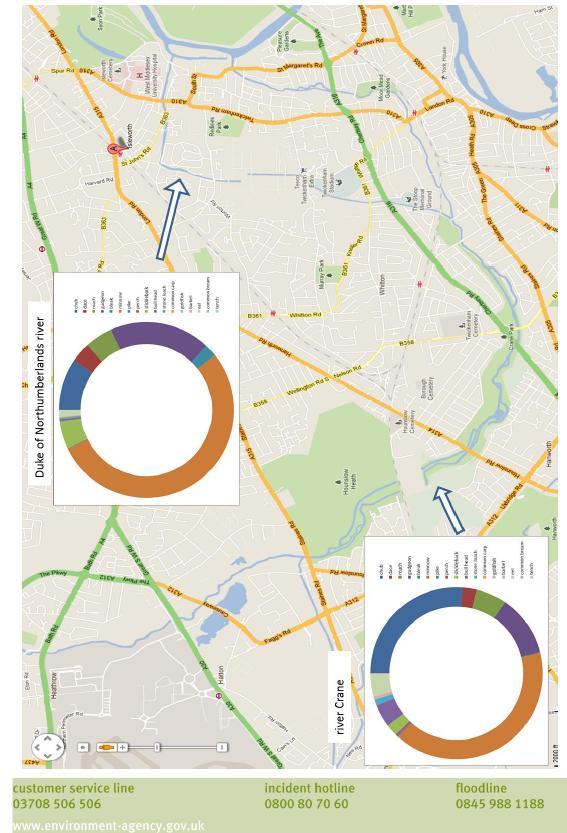
46 Appendix 3: Environment Agency Document- Fish Restocking Strategy Below is a copy of an Environment Agency document that I compiled for the Crane Valley Partnership for an initial fish stocking strategy. Its content spans from this page up to and including page
47 47
48 48
49 49
50 50
Fish population survey report
 Fish population survey report Upper River Avon Catchment This report provides a summary of results from recent fish population surveys on the Tetbury Avon, Sherston Avon and River Marden The surveys were
Fish population survey report
 Fish population survey report River Lugg This report provides a summary of results from recent fish population surveys on the River Lugg between Leominster and Hereford. The surveys were carried out to
River Crane Cranford Park
 River Crane Cranford Park A Project Proposal by the Wild Trout Trust December 2015 1 1. Introduction This report is the output of a site meeting and walk-over survey of a 1-km stretch of the River Crane
NORTH WEST WATER AUTHORITY RIVERS DIVISION SCIENTISTS DEPARTMENT TECHNICAL SUPPORT GROUP
 NORTH WEST WATER AUTHORITY RIVERS DIVISION SCIENTISTS DEPARTMENT TECHNICAL SUPPORT GROUP ELECTROFISHING SURVEY OF THE RIVER AND ITS TRIBUTARIES APRIL 1978 CALDER B. Williams N.W.W.A. RIVERS DIVISION SCIENTISTS
Know Your River Conwy Salmon & Sea Trout Catchment Summary
 Know Your River Conwy Salmon & Sea Trout Catchment Summary Introduction This report describes the status of the salmon and sea trout populations in the Conwy catchment. Bringing together data from rod
Fish population survey report
 Fish population survey report River Teme 2016 This report provides a summary of results from recent coarse fish population surveys on the River Teme between Tenbury Wells and Powick. The surveys were carried
Know Your River - River Ogmore Salmon and Sea Trout Catchment Summary
 Know Your River - River Ogmore Salmon and Sea Trout Catchment Summary Introduction This report describes the status of the salmon and sea trout populations in the Ogmore catchments. Bringing together data
Fraser River. FISH SURVEY AND MANAGEMENT INFORMATION Jon Ewert - Aquatic Biologist (Hot Sulphur Springs)
") Fraser River FISH SURVEY AND MANAGEMENT INFORMATION Jon Ewert - Aquatic Biologist (Hot Sulphur Springs) General Information: The Fraser River is a highly diverse river offering many transitions in habitat
Fraser River FISH SURVEY AND MANAGEMENT INFORMATION Jon Ewert - Aquatic Biologist (Hot Sulphur Springs) General Information: The Fraser River is a highly diverse river offering many transitions in habitat
Big Spring Creek Habitat Enhancement and Fishery Management Plans
 Big Spring Creek Habitat Enhancement and Fishery Management Plans November 5, 2012 Big Spring Events and Activities Center Newville, PA Charlie McGarrell Regional Habitat Biologist Pennsylvania Fish and
Fish population survey report
 Fish population survey report The Lower River Cam August 2016 This report provides a summary of results from recent fish population surveys on the River Cam between Cambridge and Upware. The surveys were
Know Your River River Afan Salmon and Sea Trout Catchment Summary
 Know Your River River Afan Salmon and Sea Trout Catchment Summary Introduction This report describes the status of the salmon and sea trout populations in the Afan catchments. Bringing together data from
Know Your River River Loughor Salmon and Sea Trout Catchment Summary
 Know Your River River Loughor Salmon and Sea Trout Catchment Summary Introduction This report describes the status of the salmon and sea trout populations in the Loughor catchments. Bringing together data
Fish Survey Report and Stocking Advice for Loch Milton. (Loch a Mhuilinn), May 2011
, May 2011") Fish Survey Report and Stocking Advice for Loch Milton (Loch a Mhuilinn), May 2011 Jonah Tosney Freshwater Fisheries Biologist Wester Ross Fisheries Trust 1 Loch Milton (Loch a Mhuilinn) Fish Survey Report
Fish Survey Report and Stocking Advice for Loch Milton (Loch a Mhuilinn), May 2011 Jonah Tosney Freshwater Fisheries Biologist Wester Ross Fisheries Trust 1 Loch Milton (Loch a Mhuilinn) Fish Survey Report
Fish population survey report
 Fish population survey report The Lower Great Ouse August 2016 This report provides a summary of results from recent fish population surveys on the River Great Ouse between Brampton and Earith. The surveys
NORTH RIVER FISH KILL PRELIMINARY REPORT 2014 SUMMARY
 NORTH RIVER FISH KILL PRELIMINARY REPORT 2014 SUMMARY A fish kill on Nor River was reported to e 1-800 Environmental emergency number on August 9, 2014. Representatives from e PEI Department of Environment,
Angling Trust East of England Fisheries Forum (Cambridge)
") Angling Trust East of England Fisheries Forum (Cambridge) Chris Middleton & Kye Jerrom Fisheries, Biodiversity & Geomorphology East Anglia Area 17 November 2016 This presentation is a snap shot of where
Angling Trust East of England Fisheries Forum (Cambridge) Chris Middleton & Kye Jerrom Fisheries, Biodiversity & Geomorphology East Anglia Area 17 November 2016 This presentation is a snap shot of where
The Black Bourn An Advisory Visit by the Wild Trout Trust January 2016
 The Black Bourn An Advisory Visit by the Wild Trout Trust January 2016 1. Introduction This report is the output of a site visit to the Black Bourn, also known as the River Sapiston. The Black Bourn is
Cornwell brook Cornwell Manor
 Cornwell brook Cornwell Manor An Advisory Visit by the Wild Trout Trust February 2014 1 1. Introduction This report is the output of a Wild Trout Trust visit to a tributary of the Cornwell Brook at Cornwell
Fish Community. Fish Habitat, Streams and Rivers
 Clear, Ston(e)y and White Lake Plan Fish Community The lakes support a cool/warm water fishery including muskellunge, walleye, largemouth and smallmouth bass, yellow perch, pumpkinseed, rockbass, blue
Know Your River Conwy Salmon & Sea Trout Catchment Summary
 Know Your River Conwy Salmon & Sea Trout Catchment Summary Introduction This report describes the status of the salmon and sea trout populations in the Conwy catchment. Bringing together data from rod
Know Your River Dee Salmon & Sea Trout Catchment Summary
 Know Your River Dee Salmon & Sea Trout Catchment Summary Introduction This report describes the status of the salmon and sea trout populations in the Dee catchment. Bringing together data from rod catches,
ELECTRO-FISHING REPORT 2016 UPPER TWEED
 ELECTRO-FISHING REPORT 2016 UPPER TWEED The electro-fishing programme carried out each summer by The Tweed Foundation is part of our management plan, which details the information that is required to manage
The Blue Heron Slough Conservation Bank
 1 The Blue Heron Slough Conservation Bank CONSERVATION BANKING July 19-23, 2010 CASE STUDY SERIES The Blue Heron Slough Conservation Bank (Washington) I. OVERVIEW & BACKGROUND: Location: Snohomish River
MINISTRY OF ENVIRONMENT ENVIRONMENTAL STEWARDSHIP DIVISION FISH AND WILDLIFE BRANCH. Horsefly River Angling Management Plan
 MINISTRY OF ENVIRONMENT ENVIRONMENTAL STEWARDSHIP DIVISION FISH AND WILDLIFE BRANCH Horsefly River Angling Management Plan January 30 th, 2006 Area/Fishery Description The Horsefly River watershed provides
THE DYNAMICS OF ESTUARIES AND THEIR FISH POPULATIONS: implications for fish conservation in the Tidal Thames
 THE DYNAMICS OF ESTUARIES AND THEIR FISH POPULATIONS: implications for fish conservation in the Tidal Thames Adrian C. Pinder Bournemouth University Global Environmental Solutions (BUG) ESTUARIES AND THEIR
5B. Management of invasive species in the Cosumnes and Mokelumne River Basins
 5B. Management of invasive species in the Cosumnes and Mokelumne River Basins Cosumnes River The Cosumnes River basin has a number of distinct habitat types that require different management strategies
Columbia Lake Dam Removal Project
 Columbia Lake Dam Removal Project The Columbia Lake dam located 1/4 mile upstream of the Paulins Kill River's confluence with the Delaware River in Knowlton Township, Warren County has been proposed for
Stillwater Status Report: Lough Muck, County Tyrone
 LOUGHS AGENCY OF THE FOYLE CARLINGFORD AND IRISH LIGHTS COMMISSION Stillwater Status Report: Lough Muck, County Tyrone Stillwater Fish Stock Survey Loughs Agency of the Foyle Carlingford and Irish Lights
Know Your River River Neath Salmon and Sea Trout Catchment Summary
 Know Your River River Neath Salmon and Sea Trout Catchment Summary Introduction This report describes the status of the salmon and sea trout populations in the Neath catchments. Bringing together data
Chagrin River TMDL Appendices. Appendix F
 Appendix F The following are excerpts from the Eastern Brook Trout Joint Venture s Conservation Strategy (Working Draft v.6), Conserving the Eastern Brook Trout: Strategies for Action Found at: http://www.easternbrooktrout.org/constrategy.html
ENVIRONMENT AGENCY WATER RESOURCES ACT 1991
 ENVIRONMENT AGENCY WATER RESOURCES ACT 1991 FISH REMOVAL (ROD and LINE) BYELAWS The Environment Agency, in exercise of powers conferred on it under section 210 of, and paragraph 6(1)(b) of Schedule 25
Striped Bass and White Hybrid (x) Striped Bass Management and Fishing in Pennsylvania
 Striped Bass Management and Fishing in Pennsylvania") Striped Bass and White Hybrid (x) Striped Bass Management and Fishing in Pennsylvania Prepared by R. Lorantas, D. Kristine and C. Hobbs PFBC Warmwater Unit 2005 (stocking numbers updated after 2005) Goal:
Striped Bass and White Hybrid (x) Striped Bass Management and Fishing in Pennsylvania Prepared by R. Lorantas, D. Kristine and C. Hobbs PFBC Warmwater Unit 2005 (stocking numbers updated after 2005) Goal:
Guidance Note. Hydropower Guidance Note: HGN 8 Fish Passage. When do you need to install a fish pass?
 Guidance Note Hydropower Guidance Note: This guidance note is not intended as a statement of law. It should be read in combination with, and in the context of, the relevant enactments and EU obligations.
Fifth otter survey of England
 Fifth otter survey of England 2009-2010 Summary report We are The Environment Agency. It's our job to look after your environment and make it a better place for you, and for future generations. Your environment
IFM SCOTLAND S CODE of GOOD PRACTICE for FRESHWATER FISHERIES MANAGEMENT part 1: Salmon & Trout
 IFM SCOTLAND S CODE of GOOD PRACTICE for FRESHWATER FISHERIES MANAGEMENT part 1: Salmon & Trout Guides to freshwater fisheries management have been one of the pillars of the British publishing industry
Water Framework Directive Fish Stock Survey of Lough Meelagh, August 2014
 1 Water Framework Directive Fish Stock Survey of Lough Meelagh, August 2014 Fiona L. Kelly, Lynda Connor, Emma Morrissey, John Coyne, Rory Feeney, Ronan Matson and Kieran Rocks Inland Fisheries Ireland,
Hertfordshire and North London Fisheries Monitoring Summary Report 2015
 Hertfordshire and North London Fisheries Monitoring Summary Report 15 Ben Radbone, Sampling and Collection Team January 1 We are the Environment Agency. We protect and improve the environment and make
NEVADA DEPARTMENT OF WILDLIFE STATEWIDE FISHERIES MANAGEMENT
 NEVADA DEPARTMENT OF WILDLIFE STATEWIDE FISHERIES MANAGEMENT FEDERAL AID JOB PROGRESS REPORTS F-20-52 2016 Lake Tahoe Rainbow Trout Study WESTERN REGION NEVADA DEPARTMENT OF WILDLIFE, FISHERIES DIVISION
River Restoration: Culvers Island weir removals and river naturalisation project.
 River Restoration: Culvers Island weir removals and river naturalisation project. Background Chalk streams are an incredibly rare habitat on a global scale, and owing to their international importance,
Brook Trout Life Cycle and Habitat
 Brook Trout Life Cycle and Habitat Directions: 1. As you watch this slide show, watch for vocabulary terms we learned today. The first time they appear, you will see them in RED! (not redd!) 2. At the
Salmon Five Point Approach restoring salmon in England
 Salmon Five Point Approach restoring salmon in England Our Mission To restore the abundance, diversity and resilience of salmon stocks throughout England We will do this by:- a) Maximising the production
Representativeness of Environmental DNA Metabarcoding signal in River Fish Biodiversity Assessment
 Representativeness of Environmental DNA Metabarcoding signal in River Fish Biodiversity Assessment Pont D., Civade R., Valentini A., T. Dejean et P. Taberlet Ability of edna Metabarcoding * to describe
Jason Blackburn, Paul Hvenegaard, Dave Jackson, Tyler Johns, Chad Judd, Scott Seward and Juanna Thompson
 Alberta Conservation Association (ACA) Date: 2014-2015 Project Name: Owl River Walleye and Aquatic Habitat Assessment Fisheries Program Manager: Peter Aku Project Leader: Tyler Johns Primary ACA staff
Current Status and Management Recommendations for the Fishery in the Cloverleaf Chain of Lakes
 Current Status and Management Recommendations for the Fishery in the Cloverleaf Chain of Lakes Jason Breeggemann Senior Fisheries Biologist Wisconsin Department of Natural Resources Outline DNR fisheries
Minnesota Department of Natural Resources Division of Fish and Wildlife Section of Fisheries. Stream Survey Report. Luxemburg Creek.
 Minnesota F-29-R(P)-24 Area 315 Study 3 March 2016 Minnesota Department of Natural Resources Division of Fish and Wildlife Section of Fisheries Stream Survey Report Luxemburg Creek 2015 Mark Pelham Sauk
Policy Statement on Fish Stocking in the Inland Waters of the River Tweed District
 RIVER TWEED COMMISSION Policy Statement on Fish Stocking in the Inland Waters of the River Tweed District The River Tweed Commission s policy on fish stocking 1. The policy of the River Tweed Commission
Live Fish Movements Site Permit
 Live Fish Movements Site Permit Permit to introduce and keep fish in an inland water issued under Regulation 6 of the Keeping and Introduction of Fish (England and River Esk Catchment Area) Regulations
The UK Experience with use of Triploids for Restocking
 The UK Experience with use of Triploids for Restocking Management of Brown Trout (Salmo trutta) Stocking in England and Wales Dr Brian Shields Senior Fisheries Scientist GENIMPACT 19 th to 21 st April
JadEco, LLC PO BOX 445 Shannon, IL 61078
 Introduction: With the assistance of Lake Holiday staff and volunteers, we were able to conduct an AC electrofishing survey on May 8, 27. Water temperatures were 2.3 C (8.5 F) and water clarity was decent
Little Kern Golden Trout Status:
 Little Kern Golden Trout Status: The Little Kern Golden trout (LKGT) was proposed for federal listing as Threatened under the Endangered Species Act (ESA) on September 1, 1977 by the U. S. Fish and Wildlife
An Roinn Turasoireachta, lascaigh. agus Foraoiseachta THE IMPACT OF EEL FYKE NETTING ON OTHER FISHERIES
 " An Roinn Turasoireachta, lascaigh agus Foraoiseachta THE IMPACT OF EEL FYKE NETTING ON OTHER FISHERIES Christopher Moriarty 1'1, I " I,' i l,i,! ill I!'I: " I III "!'I :,11 'I, I li,'1 li'[11 ill ':Ii
Eastern Brook Trout. Roadmap to
 Eastern Brook Trout Roadmap to CONSERVATION Our Brook Trout heritage he wild Brook Trout is an American symbol of persistence, adaptability, and the pristine wilderness that covered North America prior
Notebooks or journals for drawing and taking notes
 Title: Have to Have a Habitat Grade Level: 5 th -8 th grade Topic: Trout Habitat Background: The following chart lists the ideal conditions for trout habitat. Dissolved Oxygen: > 7 mg/l ph: 5.5-7 Next
Introduction: JadEco, LLC PO BOX 445 Shannon, IL 61078
 Introduction: was contacted to collected data on the fishery for Lake Holiday. AC Electroshocking was conducted at 2 locations on September 28, 2015. Fish population data was collected for a total of 100
Columbia Lake Dam Removal Project
 Columbia Lake Dam Removal Project Major Goals of the Columbia Lake Dam Removal: Reconnect 10 miles of the Paulins Kill River to the Delaware River, restoring natural flow regime and sediment transport.
Know Your River - Clwyd Salmon & Sea Trout Catchment Summary
 Know Your River - Clwyd Salmon & Sea Trout Catchment Summary Introduction This report describes the status of the salmon and sea trout populations in the Clwyd catchment. Bringing together data from rod
Fisheries Newsletter Winter 2016 What's been happening in Hertfordshire and North London
 Fisheries Newsletter Winter 2016 What's been happening in Hertfordshire and North London Welcome to the latest update from the Fisheries team in Hertfordshire and North London. We present a round-up of
COLUMBIA LAKE DAM REMOVAL PROJECT
 COLUMBIA LAKE DAM REMOVAL PROJECT Major Goals of the Columbia Lake Dam Removal: Reconnect 10 miles of the Paulins Kill River to the Delaware River, restoring natural flow regime and sediment transport.
NASCO Guidelines for the Protection, Restoration and Enhancement of Atlantic Salmon Habitat
 NASCO Guidelines for the Protection, Restoration and Enhancement of Atlantic Salmon Habitat 1 NASCO Guidelines for the Protection, Restoration and Enhancement of Atlantic Salmon Habitat Additional copies
Minnesota Department of Natural Resources Division of Fish and Wildlife Section of Fisheries. Stream Survey Report. Three Mile Creek 2011
 Minnesota Department of Natural Resources Division of Fish and Wildlife Section of Fisheries Stream Survey Report Three Mile Creek 2011 By Joseph D. Stewig Montrose Area Fisheries Office TABLE OF CONTENTS
TAY DISTRICT SALMON FISHERIES BOARD POLICY ON SALMON STOCKING
 TAY DISTRICT SALMON FISHERIES BOARD POLICY ON SALMON STOCKING August 2011 1 INTRODUCTION This document describes the policy adopted by the Tay District Salmon Fisheries Board for the artificial stocking
NEVADA DEPARTMENT OF WILDLIFE STATEWIDE FISHERIES MANAGEMENT
 NEVADA DEPARTMENT OF WILDLIFE STATEWIDE FISHERIES MANAGEMENT FEDERAL AID JOB PROGRESS REPORTS F-20-52 2016 LAKE TAHOE WESTERN REGION NEVADA DEPARTMENT OF WILDLIFE, FISHERIES DIVISION ANNUAL PROGRESS REPORT
My ref GLA/S&TC/Itchen 22 nd June 2018
 My ref GLA/S&TC/Itchen 22 nd June 2018 Mr Mike O Neill Environment Manager West Solent and South Downs Area Environment Agency Romsey Depot, Canal Walk Romsey SO51 7LP By email only michael.oneill@environment-agency.gov.uk
DECEMBER 2003 Instream habitat assessment for the Waikanae River
 DECEMBER 3 Instream habitat assessment for the Waikanae River Laura Watts Resource Investigations Department Executive Summary An instream habitat investigation of the Waikanae River was performed to assess
NEVADA DEPARTMENT OF WILDLIFE STATEWIDE FISHERIES MANAGEMENT
 NEVADA DEPARTMENT OF WILDLIFE STATEWIDE FISHERIES MANAGEMENT FEDERAL AID JOB PROGRESS REPORTS F-20-48 2012 LAKE TAHOE WESTERN REGION Contents NEVADA DEPARTMENT OF WILDLIFE, FISHERIES DIVISION ANNUAL PROGRESS
Insights into otter diet from spraint analysis. - Rob Britton, student research teams at Bournemouth University & Pete Reading
 Insights into otter diet from spraint analysis - Rob Britton, student research teams at Bournemouth University & Pete Reading Overview 1. Introduction into spraint analysis 2. Analysis of spraints collected
Rehabilitation of Grimes Creek, a Stream Impacted in the Past by Bucket-lined Dredge Gold Mining, Boise River Drainage, July 2008 to August 2011.
 Rehabilitation of Grimes Creek, a Stream Impacted in the Past by Bucket-lined Dredge Gold Mining, Boise River Drainage, July 2008 to August 2011. Pam Harrington TU,1020 W. Main Street Suite 440, Boise,
OKANAGAN RIVER RESTORATION INITIATIVE - FAQ
 OKANAGAN RIVER RESTORATION INITIATIVE - FAQ Initiative background: The health of the q awsitk w (Okanagan River) has been severely impacted by the channelization works that occurred in the mid-1950 s.
White-clawed crayfish survey for Ensor s Pool SSSI/SAC (Warwickshire)
") Improvement Programme for England s Natura 2000 Sites (IPENS) Planning for the Future IPENS065 White-clawed crayfish survey for Ensor s Pool SSSI/SAC (Warwickshire) Ensor s Pool Special Area of Conservation
Improvement Programme for England s Natura 2000 Sites (IPENS) Planning for the Future IPENS065 White-clawed crayfish survey for Ensor s Pool SSSI/SAC (Warwickshire) Ensor s Pool Special Area of Conservation
RECREATIONAL PONDS AND LAKES
 RECREATIONAL PONDS AND LAKES POND ECOLOGY AQUATIC PLANTS & FISH F.S. Conte Department of Animal Science University of California Davis Photos By Flickr AQUATIC PLANTS POND HEALTH Chemical Recycling Oxygen
Dauphin Lake Fishery. Status of Walleye Stocks and Conservation Measures
 Dauphin Lake Fishery Status of Walleye Stocks and Conservation Measures Date: December, 21 Dauphin Lake Fishery Status of Walleye Stocks and Conservation Measures Background: Walleye stocks in Dauphin
Freshwater Fish Assessment
 Alaska Department of Transportation & Public Facilities Seward Highway MP 7-9 6-7 Freshwater Fish Assessment March 14, 8 Prepared by HDR Alaska C Street, Suite 3 Anchorage, Alaska 993 Project Number: BR-BH-NH-OA3
RIVER CONONISH INVERTEBRATE SURVEY Dr Kjersti Birkeland
 RIVER CONONISH INVERTEBRATE SURVEY 26 Dr Kjersti Birkeland Background The Cononish, the upper reaches of the River Dochart, should be very important for spring salmon but surveys by the Tay District Salmon
Invasive Fish in the Cariboo Region. Russell Bobrowski Fisheries Biologist, BC Gov Cariboo Region Dec 19, 2017
 Invasive Fish in the Cariboo Region Russell Bobrowski Fisheries Biologist, BC Gov Cariboo Region Dec 19, 2017 Cariboo - Fishery Combination of productive lake and river fisheries 700 lakes with known game
Know Your River - Clwyd Salmon & Sea Trout Catchment Summary
 Know Your River - Clwyd Salmon & Sea Trout Catchment Summary Introduction This report describes the status of the salmon and sea trout populations in the Clwyd catchment. Bringing together data from rod
FISHERIES BLUE MOUNTAINS ADAPTATION PARTNERSHIP
 FISHERIES A warming climate, by itself, substantially affects the hydrology of watersheds in the Blue Mountains. Among the key hydrologic changes projected under all scenarios for the 2040s and beyond
River Medway Upper Medway Fly Fishers
 River Medway Upper Medway Fly Fishers An Advisory Visit by the Wild Trout Trust April 2015 1 1. Introduction This report is the output of a site meeting and walk-over survey of a 2-km stretch of the River
Advisory Visit. Bradshaw Brook, Lancashire. August 2010
 Advisory Visit Bradshaw Brook, Lancashire August 2010 1.0 Introduction This report is the output of a site visit undertaken by Tim Jacklin of the Wild Trout Trust to the Bradshaw Brook, Bolton, Lancashire
Data Report : Russian River Basin Steelhead and Coho Salmon Monitoring Program Pilot Study
 Data Report 1999-1: Russian River Basin Steelhead and Coho Salmon Monitoring Program Pilot Study Sonoma County Water Agency 215 West College Avenue Santa Rosa, California 951 Prepared by David Cook Senior
Minnesota Department of Natural Resources Division of Fish and Wildlife Section of Fisheries. Stream Survey Report. Cold Spring Creek.
 Minnesota F-29-R(P)-24 Area 315 Study 3 March 2015 Minnesota Department of Natural Resources Division of Fish and Wildlife Section of Fisheries Stream Survey Report Cold Spring Creek 2014 Mark Pelham Montrose
Steelhead Sport Fishing Regulations Proposals Vancouver Island Region for April 1, 2007
 Steelhead Sport Fishing Regulations Proposals Vancouver Island Region for April 1, 2007 Sport fishing regulations governing steelhead fishing have changed many times over the past 30 years. Generally the
Session A2 - Free access for riverine fish along the Dutch Rhine, hydraulics and construction of the Dutch Rhine fishways
 University of Massachusetts - Amherst ScholarWorks@UMass Amherst International Conference on Engineering and Ecohydrology for Fish Passage International Conference on Engineering and Ecohydrology for Fish
Restoration of rivers in Poland. Examples, possible obstacles
 Restoration of rivers in Poland Examples, possible obstacles Main purposes for river restoration projects To be in compliance with Water Framework Directive Good Environmental Status and Floods Directive;
6TH PELLETIER BROOK LAKE T15 R9, Aroostook Co. U.S.G.S. Gardner Pond, Maine (7 1/2 )
") 6TH PELLETIER BROOK LAKE T15 R9, Aroostook Co. U.S.G.S. Gardner Pond, Maine (7 1/2 ) Fishes Brook trout Minnows Blacknose dace Pearl dace Physical Characteristics Area - 27 acres Average depth - 2 feet
6TH PELLETIER BROOK LAKE T15 R9, Aroostook Co. U.S.G.S. Gardner Pond, Maine (7 1/2 ) Fishes Brook trout Minnows Blacknose dace Pearl dace Physical Characteristics Area - 27 acres Average depth - 2 feet
FISH COMMUNITIES AND FISHERIES OF THE THOUSAND ISLANDS AND MIDDLE CORRIDOR
 St. Lawrence River Discussion Paper FISH COMMUNITIES AND FISHERIES OF THE THOUSAND ISLANDS AND MIDDLE CORRIDOR Issues Below is a synopsis of fish community issues and proposed management approaches. More
EcoLogic Memorandum. TO: Ben Brezell; EDR FROM: Mark Arrigo RE: Possible Impacts of Dredging Snooks Pond DATE: 6/4/07
 EcoLogic Memorandum TO: Ben Brezell; EDR FROM: Mark Arrigo RE: Possible Impacts of Dredging Snooks Pond DATE: 6/4/07 Background EDR P.C. (EDR) has been contracted by a landowner to assess the feasibility
Impacts of Aquatic Invasive Species on the Lake Superior Fishery. by Jeff Gunderson Minnesota Sea Grant Program
 Impacts of Aquatic Invasive Species on the Lake Superior Fishery by Jeff Gunderson Minnesota Sea Grant Program Can humans really impact the fishery of such a large waterbody? Lake Superior Fishery Change
Don Pedro Project Relicensing
 Don Pedro Project Relicensing M ODESTO I RRIGATION D ISTRICT TURLOCK I RRIGATION D ISTRICT FERC PROJECT N O. 2299 Resident Fish in Don Pedro Reservoir Don Pedro Reservoir Fish Stocking (1971-Present) CDFG
Benchmark Statement Respecting the Fish, Fish Habitat and Fisheries of Fish and Little Fish Lake, within the Taseko River Watershed.
 Benchmark Statement Respecting the Fish, Fish Habitat and Fisheries of Fish and Little Fish Lake, within the Taseko River Watershed. Information Supporting the Environmental Assessment of the Prosperity
FISH PASSAGE IMPROVEMENT in California s Watersheds. Assessments & Recommendations by the Fish Passage Forum
 FISH PASSAGE IMPROVEMENT in California s Watersheds Assessments & Recommendations by the Fish Passage Forum FISH PASSAGE IMPROVEMENT in California s Watersheds The mission of the Fish Passage Forum is
Searsville Dam Removal
 Searsville Dam Removal A unique opportunity for all Presented by the Beyond Searsville Dam Coalition San Francisquito Creek flows into the San Francisco Bay near the Palo Alto Airport and Golf Course seen
MISSISSIPPI MAKEOVER A Plan for Restoration, Just Around the Bend
 MISSISSIPPI MAKEOVER A Plan for Restoration, Just Around the Bend Interim Report Card 2013 Project coordinated by the Dakota County Soil and Water Conservation District and sponsored by the Minnesota Pollution
FACT SHEET MCGREGOR LAKE RESTORATION HABITAT PROJECT POOL 10, UPPER MISSISSIPPI RIVER, WISCONSIN ENVIRONMENTAL MANAGEMENT PROGRAM
 FACT SHEET MCGREGOR LAKE RESTORATION HABITAT PROJECT POOL 10, UPPER MISSISSIPPI RIVER, WISCONSIN ENVIRONMENTAL MANAGEMENT PROGRAM LOCATION McGregor Lake is located within a mid-river island in Pool 10
HOWSHAM FISH MONITORING
 HOWSHAM FISH MONITORING Assessment of fish passage through the Archimedes Turbine and associated by-wash Client: Mann Power Consulting Authors: Pete Kibel (BSc, MSc, MIFM) Toby Coe (BSc, MSc, MIFM) Robert
Manual of Fisheries Survey Methods II: with periodic updates. Chapter 22: Guidelines for Sampling Warmwater Rivers with Rotenone
 Manual of Fisheries Survey Methods II: with periodic updates : Guidelines for Sampling Warmwater Rivers with Rotenone P. W. Seelbach, G. L. Towns, and D. D. Nelson Suggested citation: Seelbach, Paul W.,
NEVADA DEPARTMENT OF WILDLIFE STATEWIDE FISHERIES MANAGEMENT
 NEVADA DEPARTMENT OF WILDLIFE STATEWIDE FISHERIES MANAGEMENT FEDERAL AID JOB PROGRESS REPORTS F-20-52 2016 REDBAND TROUT EASTERN REGION NEVADA DEPARTMENT OF WILDLIFE, FISHERIES DIVISION ANNUAL JOB PROGRESS
HABITAT ADVISORY VISIT, RIVER LAMBOURN, BERKSHIRE, UNDERTAKEN BY VAUGHAN LEWIS, WINDRUSH AEC ON BEHALF OF LAMBOURN FLYFISHERS. MAY
 HABITAT ADVISORY VISIT, RIVER LAMBOURN, BERKSHIRE, UNDERTAKEN BY VAUGHAN LEWIS, WINDRUSH AEC ON BEHALF OF LAMBOURN FLYFISHERS. MAY 2002 Sponsored by: 1.0 Introduction This report is the output of a site
Holderness. The Three Watersheds within the Newfound Lake Drainage Dorchester. Groton Plymouth. Ashland. Hebron. Canaan. Bridgewater.
 Background Brook trout are the only native stream dwelling trout species in New Hampshire, having a historic range that extended from Georgia to eastern Canada. It is believed that wild brook trout were
STEELHEAD SURVEYS IN OMAK CREEK
 STEELHEAD SURVEYS IN OMAK CREEK 2002 Annual Report Prepared by Chris Fisher John Arterburn Colville Confederated Tribes Fish and Wildlife Department P.O. Box 150 Nespelem, WA 99155 Prepared for Project
Derbyshire, Nottinghamshire and Leicestershire Fisheries Report October - December 2014
 Derbyshire, Nottinghamshire and Leicestershire Fisheries Report October - December 2014 Title here in 8pt Arial (change text colour to black) i We are the Environment Agency. We protect and improve the