Fish population summary report
|
|
|
- Jeffry McDowell
- 6 years ago
- Views:
Transcription

.")
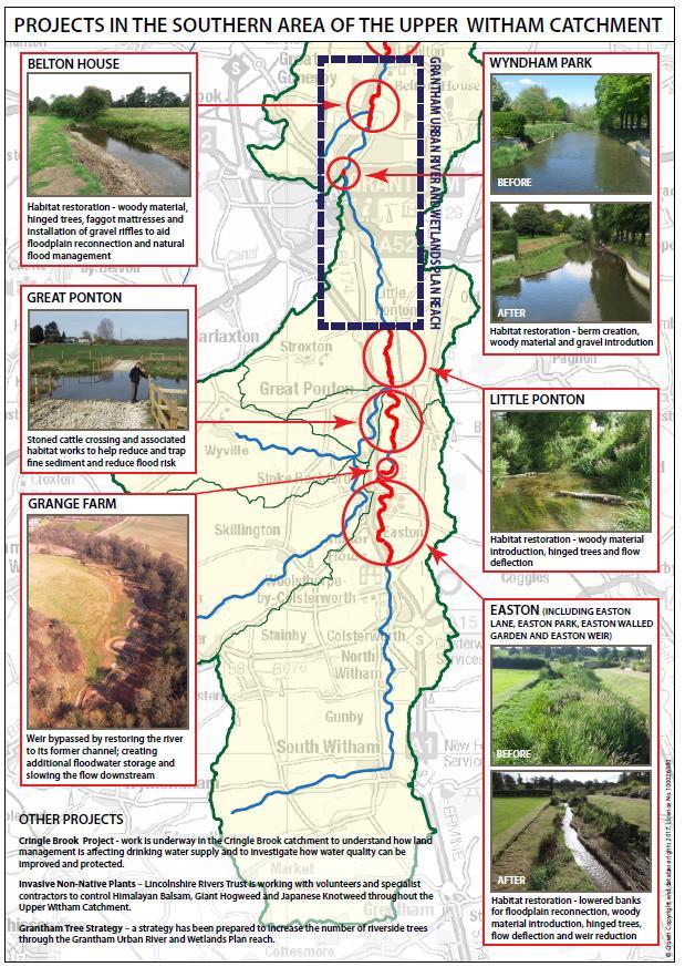
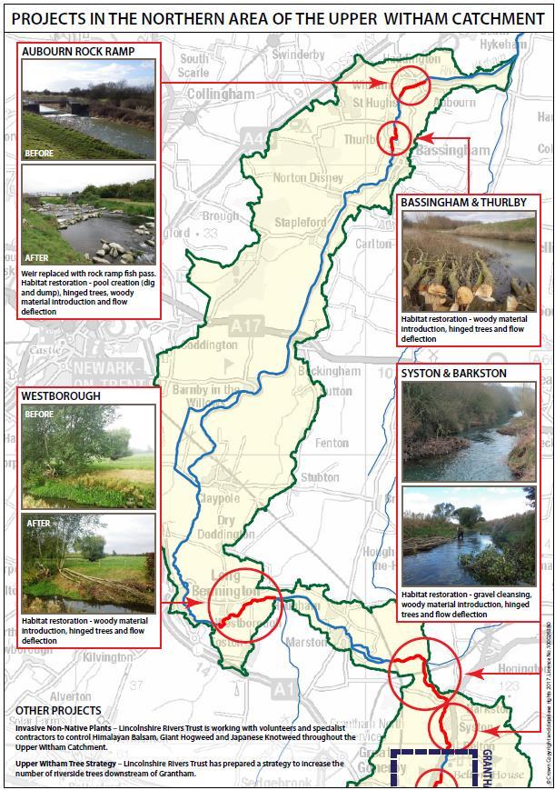
1 Fish population summary report River Witham, 2017 This report provides a brief summary of results from recent fish population surveys on the River Witham between Easton Park upstream of Grantham and Boston at the rivers tidal limit. The surveys were carried out to assess the health of the river and enable successful management of our principal fisheries. Aubourn weir rock ramp fish pass (part of several habitat improvements on the upper river). Originating team Author(s) Lincolnshire & Northamptonshire Analysis & Reporting Team Jake Reeds Date February 2018

2 Summary Twelve fisheries survey sites were surveyed during 2017 along the Witham above Lincoln. Surveys consisted of a mixture of netting and electric fishing. The wide river downstream of Lincoln was surveyed using hydroacoustic technology during the night when fish are more active. This was supplemented with side scan and multibeam sonar surveys during winter to look at fish aggregations around available habitat. Nineteen species of fish were recorded and a total of 1740 fish were captured for measurement in the upper river survey sites. Brown Trout the most widespread species in the upper river followed by chub and pike, being recorded at nine and seven sites respectively. The river downstream of Lincoln holds good numbers of adult bream and roach but the fish are difficult to find. Site locations: Sites varied between m in length, each site was isolated using stop nets at the upstream and downstream limit. It was then electric fished twice with fish being placed in a recovery tank immediately after capture. All fish are then identified for species, measured to fork length and returned to the river. The river downstream of Lincoln is surveyed using different types of sonar. Split beam sonar is undertaken at night from a boat to look at fish densities over greater distances. Multibeam sonar is used to look at how fish shoal up in winter in locations that offer suitable habitat. Side scan sonar was used to assess large shoals of bream that are present in the river downstream of Bardney.
3 Survey results - summary Fish density for fish greater than 99mm in length (fish/100mˉ²) from the survey sites undertaken is shown below. Fish lengths (mm) for all sizes are given to indicate the overall size range found at the site. Easton Cringle Paper U/S Syston Sleeper U/S Foston Claypole U/S Beckingham Haddington U/S Bracebridge Great Ponton Marston Park Brook Mills Weir Bridge Ford Bridge Bridge Bridge Bridge Brown Trout Density Size range Chub Density Size range C Bream Density Size range Dace Density Size range Eel Density Size range Gudgeon Density Size range Grayling Size range Perch Density Size range Pike Density Size range Roach Density Size range mm Tench Density Species present Size range SS, BH, MN, 3SS, BH, MN. 3SS, BH, MN, 3SS, BH, MN, 3SS, BH, MN, 3SS, BH, MN, STL, 3SS, BH, MN, STL, BL, RUF, RU BH BH, STL BH, STL BH, MN, STL STL STL STL STL STL SPL SPL Key: 3SS = Three Spined Stickleback, BH = Bullhead, STL = Stone Loach, SPL = Spined Loach, MN = Minnow, BLE = Bleak, RUF = Ruffe, RU = Rud
4 Fish density (fish/100mˉ²) Upper River fish density per site (fish>99mm): Easton Park Cringle Brook Great Ponton Paper Mills U/S Syston Weir Sleeper Bridge Marston Bridge U/S Foston Ford Claypole Bridge U/S Beckingham Bridge Haddington Bridge U/S Bracebridge Bridge Bleak Brown trout Chub Common bream Dace European eels Grayling Gudgeon Perch Pike Roach Rudd Ruffe Tench Small fish in general are difficult to catch efficiently using standard electric fishing techniques, it is highly likely that fish under 100mm in length are underrepresented in survey results. The potential voltage difference during electric fishing over small fish can be minor, meaning they are not necessarily captured when fishing. Due to the mesh size used in fish capture they can sometimes evade being picked up in a survey. Density estimates are configured using fish above 99mm in length, this gives more accurate results when looking over long term trends. The density results show a textbook shift in the fish population as the survey sites move downstream. Sites from Easton Park down to Sleeper Bridge are dominated by brown trout, the river being shallower, faster flowing with a greater habitat diversity. Coarse fish populations increase as the river becomes more traditionally lowland, with slower velocities, increased width and depth and higher levels of nutrient rich sediment. Roach numbers increase in the lower sites with the population at Bracebridge Bridge being dominated by them. Common bream and tench are all present in the sites further down towards Lincoln in small numbers but are underrepresented due to their transient shoaling nature which makes them more difficult to locate in standard surveys. Trout density was highest at Paper Mills just upstream of Grantham, traditionally this has been a good survey site with the fish seeming to prefer the fast flowing water as the river comes over the weir upstream. A good range of adult and juvenile trout were caught at the site showing available habitat is present for a diverse age structure. Great Ponton produced a good catch of trout, over 20 adult brown trout were captured in the length of just over 100m, numbers here and in sections downstream may have been influenced by past stockings. The sites at Syston and Sleeper Bridge continue to produce good density figures with adult fish to 40cm present at both. Easton Park was
5 Number of fish affected by a pollution event in April 2012, the population present there now contains adult trout that are of spawning size and age. Densities at the site now are on average with historical data, this would suggest that the section has recovered to some extent. Grayling start to appear in the river around Syston and are present in good numbers down to the Long Bennington area but are not picked up at Claypole or Beckingham. The largest grayling caught was at Syston being almost 30cm in length. Upper River length frequency results: The figures below are combined numbers of fish per species from across all survey sites graphically representing how many fish are present in a particular size range. This allows for a visual overview of the age structure and population size throughout the upper Witham. Brown Trout Fish Length (mm) Good numbers of brown trout were caught during surveying throughout sites in the upper river, the largest was in the 485mm size range from Claypole Bridge. The site in the Cringle Brook at Great Ponton provides most of fish between 65-95mm indicating that the juveniles are using it as shelter habitat before they become large enough to move out downstream into the main river. It is likely the Cringle Brook is an important spawning location for the wild trout in the river, the site there consistently produces baby trout when electric fished. Future work could look into winter redd counting surveys looking at spatial and numerical locations between the main river and the brook. Few fish were caught between the mm size ranges which could indicate a weak year in recruitment a couple of years ago. Numbers increase as the fish become larger and more mature but past stockings may be affecting the distribution, there will be wild fish in the age structure within the adult population that will help aid natural recruitment. Hydrology and habitat will be a key factor in enabling a healthy trout population in the river, the improvements made to the river led by the local Fisheries, Biodiversity and Geomorphological team will go some way to address this and is illustrated later in the report.
 The largest chub caught upstream of")
6 Number of fish Good size trout taken from the Witham (artistically held to look big, note the concentration). Chub Fish Length (mm) The largest chub caught upstream of Foston Ford was in the 515mm size bracket which would represent a fish of around 5lbs. The smallest fish caught was 75mm which would have been spawned in Numbers of fish in the juvenile age range show that recruitment is taking place in the river, they are often underrepresented as small chub are not often found in great numbers when surveying, they seem to be expert at finding space in the river. Relatively good numbers are present through the low 20cm size range with fewer fully mature adult fish in the 30-40cm size bracket. There are still specimen fish present in the river to be fished for.
7 Number of fish Number of fish Dace Fish Length (mm) Few juvenile dace below 80mm were caught during surveying but this is often the case, they tend to favour habitat where they can t be caught easily and are underrepresented in most fisheries data sets. Most fish reside between 90mm and 130mm long and they are present in good numbers that should hopefully follow through into more adult fish being present in the future. The largest fish caught measured 226mm and would represent a fish of around 7 years old from Sleeper Bridge. Eel Fish Length (mm) Few eels were caught in the upper river. The decline in the species is most marked in relatively shallow watercourses towards the upper areas of rivers such as the Witham. Sections such as Claypole in the late 1980 s were returning almost 400 eels alone from one site. In 2017 just over 20 eels were caught from eleven electric fishing sites throughout the entire upper river. The most likely reason for this shallow water decline is the lack of recruitment at the tidal limits as lower numbers of elvers arrive after their journey across the Atlantic. Eel distribution within a river relies greatly on the density present, as does their sex, they arrive neither male nor female, higher densities produce males and lower densities females. As fewer elvers come into the Witham the lower density produces less of a migratory push to move up river meaning the upper sections of rivers are receiving fewer eels than they used to. This is shown in the sizes we caught, most were mature female eels living in low densities that would have been in the section for around ten years or over. The largest eel in the 675mm length distribution would be a female that would be starting to get to the size where they are ready to begin their seaward migration to spawn. A historical electrical fishing survey site at Blackmoor Farm on the Witham in 1987 caught 960 eels, this is one of the highest catches from a single survey site anywhere around the country. To move from those numbers to the levels we see now within a thirty year time scale indicates the huge decline that the species has undergone. Increased levels of bird and mammal predation combined with lower levels of recruitment has affected the species dramatically.
8 Number of fish Number of fish Grayling Fish Length (mm) Juvenile grayling were caught showing that natural recruitment is taking place in the river. In general grayling numbers were low, the spatial range within the river which they seem to reside in is around 12km long downstream of Grantham. New fish passes and habitat improvement schemes will hopefully go some way to addressing this and will allow for increased numbers. Relatively good numbers of fish are present as fish start to reach maturity with fewer larger adults present. Perch Fish Length (mm) Perch numbers are low within the upper river but the size being attained by some of the fish is worth being looked at. Numbers of fish reaching mature adulthood are small but the largest fish was in the 360mm bracket. This is a specimen fish of over 2lbs and well worth angling for. Foston Ford contained the highest level of big perch, a Grantham Angling Association club book is needed to fish this section. The upper river is well worth a go for a large fish.
9 Number of fish Roach Fish Length (mm) The majority of roach caught were from Bracebridge Bridge just upstream of Lincoln, the largest fish caught was at Claypole at just over 20cm. A similar maximum size was found at Bracebridge, Sleeper Bridge and at Beckingham. Predation is a large factor for roach growth in watercourses such as the upper Witham, the larger fish are an ideal size for avian predation was has no doubt impacted the success of the population in recent years. Roach of 30cm and over were a common feature of the survey results during the s and early 1990 s. These fish are no longer present as fish are being predated upon before they reach these sizes. Habitat improvements should help to negate these impacts as more shelter refuge is installed in the upper river. Recruitment is taking place, it is an issue of providing enough shelter for the fish to grown on to larger sizes.
10 Historical data: Data from three sites where we hold long term electric fishing records is shown below. Results are given in fish density/100mˉ² for fish greater than 99mm in length, fish smaller than this are unrepresented in the data due to their size making results from them inaccurate. 80 Fish density (fish/100mˉ²) Haddington Road Bridge Historical catch data, Haddington Road Bridge. Historical density results from Haddington Road Bridge are shown above. Figures fluctuate with high numbers of coarse fish present in some survey years. Since 2011 the density from Haddington has been below the long term average of 28 fish/100mˉ². This could be caused by environmental factors such as river flow or water temperatures. Both have the ability to move fish away from locations in order to seek out refuge when surveying is undertaken. It is likely that increased predation on the river will hamper density levels increasing to relatively high numbers but monitoring will be able ascertain how the river is responding. The improvements to habitat in the river being made will help to increase fish density by offering more shelter habitat, this will help with both recruitment, survival and the overall fecundity of the river.
11 Fish density (fish/100mˉ²) Foston Ford Historical catch data from Foston Ford. The river above Foston Ford averages just over 10 fish/100m ˉ². Recent years have been below this but results from 2010 were good with a large shoal of dace pushing the density figures up. In 2005 good numbers of dace and chub were found in the section which recorded the highest fish density since surveying began there in This section can suffer from very high flows during high rainfall events, it is heavily embanked and fish have limited shelter to take refuge in.
12 Fish density (fish/100mˉ²) Great Ponton Historical catch data from Great Ponton. The fish density at Great Ponton is likely to be affected by previous stockings by the trout fishing club so the figures are only representative of what is present in the section rather than any longer term trends. When density has been high it is likely to have been heightened by the presence of stocked fish. The club now operate a no stocking policy and catch and release policy. Surveying carried out in the future will be able to see how fish numbers are responding to this change. Future monitoring could include specific redd counting and egg survival investigations to be able to link this in with habitat improvement schemes.

13 Hydroacoustic data - Wide Witham: Witham results May Environment Agency copyright All rights reserved. Ordnance Survey licence number
14 The river below Lincoln was surveyed using a split beam sonar transducer during night time in May starting at 10pm. The survey ran from Stamp End Lock to Bardney Lock finishing at 1am, the next night from Bardney to Dogdyke finishing at 2am and then from Dogdyke to Boston for a similar duration on the third evening. The system detects fish in the water column and allows a density estimate to be mapped out against their location in the river. This is displayed in the map above, the larger the circle the higher the fish density. The Witham is surveyed in May because if it is left any later it becomes too weedy for the equipment to image the fish, a similar case on the Welland and Ancholme locally. Stamp End to Bardney: Fish distribution here was skewed towards the city end of the section, this is a common occurrence in lowland rivers where fish utilise habitat around human structure. The area downstream of Stamp End lock contained the highest densities, the trees on the right hand bank offer good refuge habitat. The river level here stays at a constant throughout winter and summer. This allows fish to utilise marginal habitat through all times of the year, in cold temperatures and in high flows. Numbers dropped off as the river moves out past Washingborough but picked up again under the boat moorings at Bardney Lock. Large echoes on the display indicated that larger fish species such as bream, tench and pike were present in this section, the ability for these to be identified and monitored in the future has been greatly increased by the acquisition of a side scan sonar. This will be embedded in our monitoring alongside future split beam work and is demonstrated in following pages. Bardney to Dogdyke: Fish were located around Bardney downstream to Kirkstead, this is often the case when the river is at summer retention level. The side channels such as Nocton Delph, the Sincil Dyke, Timberland Delph and Billinghay Skirth all become available as side channel habitat for spawning and foraging. This section of the river downstream of Bardney consistently held the most bream during the year when a tagging project was run on the river between In a highly modified channel such as the Lower Witham than side channels stand out as beacons to the fish present, they will help to hold the fish in the upper river. Dogdyke to Boston: The river downstream of Dogdyke to Boston had the lowest fish density in the wide Witham. In certain stretches no fish were located using the split beam transducer. The river is uniform, barren and has no suitable off channel habitat. Overwintering here for most species is hard work, the level is dropped removing all access to overhanging trees which are crucial for small fish to shelter in. Langrick Bridge is the only real area providing overhead cover and roach can be found under the bridge and around the boats but avian predation is constant here during winter. Side scan/multibeam survey results: Side scan surveys produce a bank to bank bird s eye view of the river bed, this allows fish to be imaged and the location they are present to be logged. While it may not produce density estimates it can give a very good indication as to why a fish population is behaving as it is. This method was used to assess fish numbers on the lower Witham for the first time during winter Firstly to establish bream shoaling in the main river and also to assess where fish are overwintering, this helps to highlight how habitat plays an important role in the fish population. Multibeam sonar uses over 100 beams working next to one another at very high frequencies. This gives back a highly detailed live video image under the water. It is a vital tool for looking into how fish utilise habitat and the need to protect bankside trees. This can see through darkness and high levels of turbidity in the water.

15 The side scan image produced while surveying. Multibeam sonar on a pan and tilt unit.

16 Sincil Dyke: The Sincil is a known overwintering location for bream shoals. If they aren t in it sheltering from high flows they sit in the basin where it joins the main river. The image below shows the bridge access to Bardney Lock, anytime from November through to March this section of the river is worth bream fishing. The Sincil itself can hold very large shoals, over 1000 adult fish were in a 100m survey site in 2010 about half a mile up from where it joins the Witham. The side scan survey imaged over 100 fish in the entrance in early February Bream shoal at the entrance to the Sincil Dyke. Marked fish on the right.


17 Directly adjacent to the entrance to the Sincil Dyke is Bardney Lock pit. The photo on the left shows the old railway bridge with the lock pit just above it. On the side scan image below left the stanchions for the bridge can be seen towards the bottom of the scan on the banks. A large bream shoal was present stretching from just above the bridge past the lock pit up towards the arm of the river that comes past Branston Island. This contained approximately 355 adult bream averaging around 4-5lbs. This is another favoured location for the fish as they can feed in the channel and move into either the lock pit or the Sincil Dyke if the flows in the river pick up. In early 2017 an experiment was undertaken to establish the importance of the willow trees along the Sincil Dyke for both adult bream and 0+ and 1+ fish juvenile fish during winter. A multibeam sonar was set up and the area was baited using ground bait. The photo below shows the location and set up. Within five minutes of baiting the area the sonar screen was full of adult bream and thousands of cyprinid fry and 1+ fish. The image to the left shows the adult bream and the thousands of fry present in the Sincil during winter when it is groundbaited. Because they are here during winter it can also be a prolific pike fishery.


18 Bardney Moorings The moorings at Bardney provide vital overhead cover for large roach during winter when macrophyte cover has died back in winter. There are often shoals in excess of ten thousand fish below them, the river either side can be devoid of large roach for mile at a time during winter retention level. The image from Bardney Moorings on the left illustrates the tightness of the shoaling Roach gather round moorings, under bridges and in Dogdyke marina in large numbers. The willow trees in the Sincil Dyke provide critical refuge habitat for them. At the entrance to the Kyme Eau at Chapel Hill fish can be seen under the moorings so tightly packed in the sonar cannot image between them. All display classic persecution behaviour. Predation by cormorants plays a large part in this shoaling behaviour. Winter shoaling is common amongst cyprinids but the extent to which the fish seek out and shoal in massive numbers is exacerbated by the efficiency of avian predation. When the colour falls out of the river the lower river is left with very little shelter habitat. If a roach spends time in open water in daylight there is a high chance it will be eaten, cormorants feed heavily at Langrick Bridge daily during the winter. Roach there have little or no other shelter habitat to escape this form of predation.
19 WFD Classification: Current WFD fisheries classification for the Witham system ranges from Poor to Good over 6 sites undertaken on the river throughout surveying years ( ). Classifications should be put in perspective as results can be heavily influenced by fish location and river conditions. Water body ID Sites in water body Fish status Reason Overall River status GB Witham - US EASTON PARK POOR GB Witham - DS GRANTHAM GOOD GB Witham - US LINCOLN POOR Low species numbers and low densities at EASTON PARK Driven by good catches at PAPERMILLS, MARSTON and CRINGLE BROOK. Driven by low catches at Bracebridge Bridge GB Witham - LOWER NA NA NA POOR GOOD POOR Water Framework Directive water bodies with classification status for 2016 (data based on catches from ). Health of fish population: Results from the upper river electric fishing sites provided good densities with some sites containing good numbers of fish and specimen chub and perch. Habitat improvements in this section by the Fisheries, Biodiversity and Geomorphology team will provide increased opportunities for spawning, refuge and foraging that will in the long term lead to higher densities and larger fish. The river upstream of Lincoln holds good numbers of roach and some bream, new technology will enable us to assess the impact that Brayford Pool has on the system, Lincoln and District Angling Association have the pool on membership and day ticket. At present we cannot estimate just how much of the population is present there, it is likely given the evidence for fish shoaling around human structure that it will be significant especially during winter. This is applicable to the bream that reside in the area. The lower river downstream of Bardney contains roach and bream in numbers but excessive weed growth in the summer can hamper catching them. The weed is driven by high levels of phosphate and nitrogen in the river, mixed with clear water and sunshine it is the perfect combination for large scale growth. Habitat is poor on the lower river, there is very little in the way of natural complex margins or trees that can provide vital cover for fish. This leads to the winter shoaling effect we see where the fish are not available to anglers because they are tightly bunched around key locations. The winter retention level and corresponding increased predation and loss of side channels is the key restriction to the fish population present. The removal of access to side tributaries, emergent vegetation and the condition of the delphs to the west of the river is discussed in the following pages. The Sincil Dyke and the shelter the willow trees along it provide are absolutely critical to the success of the entire fish population in the lower river. It needs the utmost protection.

20 Angling: Trout and grayling fishing in the upper river is good with certain stretches containing some good wild fish. These sections are fishable under a Grantham Fly Fishers membership only. Chub, dace and perch are worth fishing for around Foston and Long Bennington, these sections are available on a club book from Grantham Angling Association. For winter bream/roach/pike fishing the Sincil Dyke is the only place to fish. The fish have little option but to overwinter around this section. Summer on the lower river when the levels come up the bream can be highly mobile but the sections between Bardney and Tattershall Bridge will be likely spots, finding colour in the water during the summer will be key to this. Boston and District Angling Club have a section upstream of Tattershall including weedy bay. Roach will spread out from their overwintering areas into the main river during summer. Again the section from Bardney to Tallington is the best bet. They can pack in tightly to the willows on the Sincil dyke in winter, fish close to them. Habitat improvement work: Several habitat improvement schemes have been underway on the upper river over the past five years. All of them are aimed at increasing the available shelter, feeding and spawning habitat for fish in the river. This is combined with the benefits that are brought about by the fish passes being installed in the river to allow higher degree of movement. Some examples of the work carried out by the local FBG team are shown in the following pages. Off channel fish refuge at Chapel Hill on the Lower Witham.
21
22

23 Winter retention level - Lower Witham: Each November the river downstream of Bardney Lock is dropped for five months to increase winter capacity for flood defence purposes. The lower Witham is very difficult to drain, it has low gradient, has no washlands downstream of Branston Island and is effective tide locked when the tide is in at Boston. The extra capacity added by lowering the river helps to negate against this but has significant impacts on the fish present. Fish during wintertime need marginal habitat to provide refuge from predation and high flows, this is especially important in the recent decade because of increased levels of predation. Lowering the river removes the most significantly important habitat in the river at a key time of year. Off channel habitat such as Nocton Delph should be a vital overwintering location for all species of fish both adult and juvenile. During winter retention levels it can average 20cm in depth. Nocton Delph during winter level. This effect is also present on the Kyme Eau, the Billinghay Skirth and the Timberland Delph. All would usually act as overwintering locations for the fish. However they do not hold the water levels necessary to do so. In Feb 2018 a side scan of the Kyme Eau was undertaken from Chapel Hill to Bottom Lock which is the first upstream barrier on the Eau. Not a single fish was recorded in the river, it averaged 40cm deep and is offering no shelter to any species of fish. This problem is confounded by the levels of sediment present in the side channels. Nocton Delph has in places over 1.5m of silt, combine this with a low winter level and 20cm of water is the result. To illustrate this some cross sectional transects of the tributaries of the lower river were carried out in 2014.
24 Depth (M) Depth (M) Two sites each were undertaken on the Kyme Eau, Billinghay Skirt, Timberland Delph, Nocton Delph and Sincil Dyke. The Kyme Eau is illustrated below, the light blue line is summer water level, the dark blue winter water level and the brown is the top of the sediment. Sediment is accounting for half the depth during summer and two thirds during winter. This was similar to all the other tributaries apart from the Sincil Dyke. 0 Kyme Eau The Sincil has an open connection to the Witham and is the most upstream of the tributaries to be affected by the winter retention. The difference in why fish chose to overwinter here is illustrated below, combine the depth that it retains during winter, the lack of sediment present and the overhead cover from trees and it offers real shelter habitat. Sincil Dyke The winter level is historic on the Witham and was in place during its angling height in the 1960 s and 1970 s so it is important to illustrate why it has become so important for fish and will be into the future. Firstly predation on fish populations has increased by a significant amount since then, having overhead cover wasn t as important as it is now. Without it fish are extremely vulnerable, this leads to heavy loses and large scale changes in behaviour which make them very hard to catch. Second is the level of sediment that has built up to render the side delphs uninhabitably when the level is dropped.


25 The middle section of Nocton Delph in This was an important off channel spawning site for bream, sediment build up colonised by emergent macrophytes has left it unfit for use for fish during summer and winter. The lower end of Nocton Delph, summer Nutrient rich sediment helps to drive large scale filamentous algal growth which causes poor water quality.
26 If possible mutually beneficial opportunities for both flood defence and fisheries arise in the future these will be looked at to try alleviate some the pressures acting on the fish present. Next survey year: 2020 Will look at changes in fish populations associated with the habitat improvement schemes in the upper river. Will look into the total bream population of Lower River, at present we only have snapshot of how many are there. Will look into fish populations in the Brayford pool to assess how significant it is to the section of the river upstream of Lincoln. If you would like to discuss the information presented in this report, please contact: Jake Reeds, Fisheries Officer, Analysis & Reporting Team, Spalding Before you go fishing don t forget: You must have a valid Environment Agency rod licence and permission from the fishery owner; You must comply with the fisheries byelaws; The coarse fish close season (15th March to 15th June inclusive) applies to all rivers, streams and drains in England and Wales but not most stillwaters. Stillwater fishery owners can still have their own close season and rules, so please check with them before setting out. Report illegal fishing: If you see any fishing, netting or trapping you think may be illegal, please do not tackle it yourself. Call us immediately on and tell us: Exactly where the alleged offence is taking place; What is happening; How many people are involved and their descriptions; The registration numbers of any vehicles involved. If you prefer to remain report an environmental crime anonymously call Crimestoppers on or
Fish population survey report
 Fish population survey report River Lugg This report provides a summary of results from recent fish population surveys on the River Lugg between Leominster and Hereford. The surveys were carried out to
Fish population survey report
 Fish population survey report River Teme 2016 This report provides a summary of results from recent coarse fish population surveys on the River Teme between Tenbury Wells and Powick. The surveys were carried
Fish population survey report
 Fish population survey report Upper River Avon Catchment This report provides a summary of results from recent fish population surveys on the Tetbury Avon, Sherston Avon and River Marden The surveys were
Angling Trust East of England Fisheries Forum (Cambridge)
") Angling Trust East of England Fisheries Forum (Cambridge) Chris Middleton & Kye Jerrom Fisheries, Biodiversity & Geomorphology East Anglia Area 17 November 2016 This presentation is a snap shot of where
Angling Trust East of England Fisheries Forum (Cambridge) Chris Middleton & Kye Jerrom Fisheries, Biodiversity & Geomorphology East Anglia Area 17 November 2016 This presentation is a snap shot of where
River Welland fish pass update and monitoring report 2014
 River Welland fish pass update and monitoring report 2014 Tallington fish pass in early June after heavy rainfall. 1 Executive Summary Fish and eel passes were installed during 2012/13 on two previously
Know Your River - Clwyd Salmon & Sea Trout Catchment Summary
 Know Your River - Clwyd Salmon & Sea Trout Catchment Summary Introduction This report describes the status of the salmon and sea trout populations in the Clwyd catchment. Bringing together data from rod
Salmon Five Point Approach restoring salmon in England
 Salmon Five Point Approach restoring salmon in England Our Mission To restore the abundance, diversity and resilience of salmon stocks throughout England We will do this by:- a) Maximising the production
MINISTRY OF ENVIRONMENT ENVIRONMENTAL STEWARDSHIP DIVISION FISH AND WILDLIFE BRANCH. Horsefly River Angling Management Plan
 MINISTRY OF ENVIRONMENT ENVIRONMENTAL STEWARDSHIP DIVISION FISH AND WILDLIFE BRANCH Horsefly River Angling Management Plan January 30 th, 2006 Area/Fishery Description The Horsefly River watershed provides
Fish Survey Report and Stocking Advice for Loch Milton. (Loch a Mhuilinn), May 2011
, May 2011") Fish Survey Report and Stocking Advice for Loch Milton (Loch a Mhuilinn), May 2011 Jonah Tosney Freshwater Fisheries Biologist Wester Ross Fisheries Trust 1 Loch Milton (Loch a Mhuilinn) Fish Survey Report
Fish Survey Report and Stocking Advice for Loch Milton (Loch a Mhuilinn), May 2011 Jonah Tosney Freshwater Fisheries Biologist Wester Ross Fisheries Trust 1 Loch Milton (Loch a Mhuilinn) Fish Survey Report
Know Your River Conwy Salmon & Sea Trout Catchment Summary
 Know Your River Conwy Salmon & Sea Trout Catchment Summary Introduction This report describes the status of the salmon and sea trout populations in the Conwy catchment. Bringing together data from rod
2013 Electrofishing Program Summary. Miramichi Salmon Association In collaboration with the Department of Fisheries and Oceans
 2013 Electrofishing Program Summary Miramichi Salmon Association In collaboration with the Department of Fisheries and Oceans Prepared by: Alex Parker Biologist Miramichi Salmon Association 485, Route
Fish population survey report
 Fish population survey report The Lower Great Ouse August 2016 This report provides a summary of results from recent fish population surveys on the River Great Ouse between Brampton and Earith. The surveys
NEVADA DEPARTMENT OF WILDLIFE STATEWIDE FISHERIES MANAGEMENT
 NEVADA DEPARTMENT OF WILDLIFE STATEWIDE FISHERIES MANAGEMENT FEDERAL AID JOB PROGRESS REPORTS F-20-52 2016 Lake Tahoe Rainbow Trout Study WESTERN REGION NEVADA DEPARTMENT OF WILDLIFE, FISHERIES DIVISION
River Medway Upper Medway Fly Fishers
 River Medway Upper Medway Fly Fishers An Advisory Visit by the Wild Trout Trust April 2015 1 1. Introduction This report is the output of a site meeting and walk-over survey of a 2-km stretch of the River
ELECTRO-FISHING REPORT 2016 UPPER TWEED
 ELECTRO-FISHING REPORT 2016 UPPER TWEED The electro-fishing programme carried out each summer by The Tweed Foundation is part of our management plan, which details the information that is required to manage
FISH COMMUNITIES AND FISHERIES OF THE THOUSAND ISLANDS AND MIDDLE CORRIDOR
 St. Lawrence River Discussion Paper FISH COMMUNITIES AND FISHERIES OF THE THOUSAND ISLANDS AND MIDDLE CORRIDOR Issues Below is a synopsis of fish community issues and proposed management approaches. More
Know Your River Conwy Salmon & Sea Trout Catchment Summary
 Know Your River Conwy Salmon & Sea Trout Catchment Summary Introduction This report describes the status of the salmon and sea trout populations in the Conwy catchment. Bringing together data from rod
Guidance Note. Hydropower Guidance Note: HGN 8 Fish Passage. When do you need to install a fish pass?
 Guidance Note Hydropower Guidance Note: This guidance note is not intended as a statement of law. It should be read in combination with, and in the context of, the relevant enactments and EU obligations.
An Roinn Turasoireachta, lascaigh. agus Foraoiseachta THE IMPACT OF EEL FYKE NETTING ON OTHER FISHERIES
 " An Roinn Turasoireachta, lascaigh agus Foraoiseachta THE IMPACT OF EEL FYKE NETTING ON OTHER FISHERIES Christopher Moriarty 1'1, I " I,' i l,i,! ill I!'I: " I III "!'I :,11 'I, I li,'1 li'[11 ill ':Ii
NORTH WEST WATER AUTHORITY RIVERS DIVISION SCIENTISTS DEPARTMENT TECHNICAL SUPPORT GROUP
 NORTH WEST WATER AUTHORITY RIVERS DIVISION SCIENTISTS DEPARTMENT TECHNICAL SUPPORT GROUP ELECTROFISHING SURVEY OF THE RIVER AND ITS TRIBUTARIES APRIL 1978 CALDER B. Williams N.W.W.A. RIVERS DIVISION SCIENTISTS
IFM SCOTLAND S CODE of GOOD PRACTICE for FRESHWATER FISHERIES MANAGEMENT part 1: Salmon & Trout
 IFM SCOTLAND S CODE of GOOD PRACTICE for FRESHWATER FISHERIES MANAGEMENT part 1: Salmon & Trout Guides to freshwater fisheries management have been one of the pillars of the British publishing industry
IFS Carp Management Program 2014
 Carp Captures at a Glance Lake Sorell January March 2014 (Total) Adult/Juvenile Total 1995 to present 1761 0-1761 39,303 Lake Crescent January March 2014 (Total) Adult/Juvenile Total 1995 to present 0
Dauphin Lake Fishery. Status of Walleye Stocks and Conservation Measures
 Dauphin Lake Fishery Status of Walleye Stocks and Conservation Measures Date: December, 21 Dauphin Lake Fishery Status of Walleye Stocks and Conservation Measures Background: Walleye stocks in Dauphin
Know Your River Dee Salmon & Sea Trout Catchment Summary
 Know Your River Dee Salmon & Sea Trout Catchment Summary Introduction This report describes the status of the salmon and sea trout populations in the Dee catchment. Bringing together data from rod catches,
Fish Ageing Survey Report The Gall Pond Our Ref: 14#194 Date:November 2014
 Fish Ageing Survey Report Our Ref: 14#194 Date:November 214 About this water is a 2.25 acre match/pleasure fishery with an average depth of around 7 feet. The water was sampled between April and July 214.
Salmon spawning report 2010
 Salmon spawning report 21 Midlands Region, West Julie Cowley, April 211 We are the Environment Agency. It's our job to look after your environment and make it a better place - for you, and for future generations.
Introduction: JadEco, LLC PO BOX 445 Shannon, IL 61078
 Introduction: was contacted to collected data on the fishery for Lake Holiday. AC Electroshocking was conducted at 2 locations on September 28, 2015. Fish population data was collected for a total of 100
Know Your River River Afan Salmon and Sea Trout Catchment Summary
 Know Your River River Afan Salmon and Sea Trout Catchment Summary Introduction This report describes the status of the salmon and sea trout populations in the Afan catchments. Bringing together data from
Know Your River - River Ogmore Salmon and Sea Trout Catchment Summary
 Know Your River - River Ogmore Salmon and Sea Trout Catchment Summary Introduction This report describes the status of the salmon and sea trout populations in the Ogmore catchments. Bringing together data
Fish Community. Fish Habitat, Streams and Rivers
 Clear, Ston(e)y and White Lake Plan Fish Community The lakes support a cool/warm water fishery including muskellunge, walleye, largemouth and smallmouth bass, yellow perch, pumpkinseed, rockbass, blue
Fish Ageing Survey Report The Gall Pond Our Ref:13#160 Date: 18/02/2014
 Fish Ageing Survey Report The Gall Pond Our Ref:13#160 Date: 18/02/2014 About this water The Gall Pond is a modest sized (2.25 acres) estate lake fishery, with an average depth of 7ft. It contains a range
The UK Experience with use of Triploids for Restocking
 The UK Experience with use of Triploids for Restocking Management of Brown Trout (Salmo trutta) Stocking in England and Wales Dr Brian Shields Senior Fisheries Scientist GENIMPACT 19 th to 21 st April
Know Your River River Loughor Salmon and Sea Trout Catchment Summary
 Know Your River River Loughor Salmon and Sea Trout Catchment Summary Introduction This report describes the status of the salmon and sea trout populations in the Loughor catchments. Bringing together data
OKANAGAN LAKE FISH MANAGEMENT PLAN SUMMARY
 lin,'roduction 1990-1995 OKANAGAN LAKE FISH MANAGEMENT PLAN SUMMARY B.C. Environment's Fisheries Branch looks after the province's freshwater fish. In Okanagan Lake, game fish inventories reveal an alarming
Draft report on one day visit to Brampton Bryan, R. Teme
 Dr Nick Giles & Associates, 50 Lake Road, Verwood, Dorset, BH31 6BX. Telephone 01202 824245 Fax 01202 828056 email nickgiles@cix.co.uk Consultants : Freshwater Fisheries, Conservation & Wetland Ecology
Know Your River - Clwyd Salmon & Sea Trout Catchment Summary
 Know Your River - Clwyd Salmon & Sea Trout Catchment Summary Introduction This report describes the status of the salmon and sea trout populations in the Clwyd catchment. Bringing together data from rod
P.O.Box 23 Sw an Reach 3903 Victoria Phone E m ail- bigpond.com
 Lynton.G.Barr P.O.Box 23 Sw an Reach 3903 Victoria Phone 03 5156 4674 E m ail- delbarr1@ bigpond.com Around the Jetties Information Sheet Prepared by Lynton Barr Banning Netting at the Gippsland Lakes
TAY DISTRICT SALMON FISHERIES BOARD POLICY ON SALMON STOCKING
 TAY DISTRICT SALMON FISHERIES BOARD POLICY ON SALMON STOCKING August 2011 1 INTRODUCTION This document describes the policy adopted by the Tay District Salmon Fisheries Board for the artificial stocking
Fish population survey report
 Fish population survey report The Lower River Cam August 2016 This report provides a summary of results from recent fish population surveys on the River Cam between Cambridge and Upware. The surveys were
Cormorants and fish populations
 Cormorants and fish populations DOCUMENTATION OF EFFECTS NIELS JEPSEN DTU AQUA, SILKEBORG EU-Parliament, October 2018 Main points: 1. Short overview of the development of the cormorant conflict 2. Predation
Big Spring Creek Habitat Enhancement and Fishery Management Plans
 Big Spring Creek Habitat Enhancement and Fishery Management Plans November 5, 2012 Big Spring Events and Activities Center Newville, PA Charlie McGarrell Regional Habitat Biologist Pennsylvania Fish and
Know Your River - Ogwen Salmon & Sea Trout Catchment Summary
 Know Your River - Ogwen Salmon & Sea Trout Catchment Summary Introduction This report describes the status of the salmon and sea trout populations in the Ogwen catchment. Bringing together data from rod
STUDY PERFORMANCE REPORT
 STUDY PERFORMANCE REPORT State: Michigan Project No.: F-81-R-3 Study No.: 491 Title: Evaluation of lake sturgeon Acipenser fulvescens populations in the St. Clair River and Lake St. Clair Period Covered:
The Black Bourn An Advisory Visit by the Wild Trout Trust January 2016
 The Black Bourn An Advisory Visit by the Wild Trout Trust January 2016 1. Introduction This report is the output of a site visit to the Black Bourn, also known as the River Sapiston. The Black Bourn is
Insights into otter diet from spraint analysis. - Rob Britton, student research teams at Bournemouth University & Pete Reading
 Insights into otter diet from spraint analysis - Rob Britton, student research teams at Bournemouth University & Pete Reading Overview 1. Introduction into spraint analysis 2. Analysis of spraints collected
What was the historic coaster fishery like?
 1 of 6 1/30/2012 12:25 PM Home About Topics Contact Us Fishing Calendar Fish ID Tips FAQs Hack Noyes Research Vessel Is it a unique strain long lost from Wisconsin's shoreline? Fisheries Reports Tributaries
STEELHEAD SURVEYS IN OMAK CREEK
 STEELHEAD SURVEYS IN OMAK CREEK 2002 Annual Report Prepared by Chris Fisher John Arterburn Colville Confederated Tribes Fish and Wildlife Department P.O. Box 150 Nespelem, WA 99155 Prepared for Project
Angling in Manitoba (2000)
") Angling in Manitoba (2000) TABLE OF CONTENTS Page Introduction 1 Angler Profile 2 Angling Effort 7 Catch and Harvest 10 Angling Expenditures 13 Bait Use 16 Nonresident Trip Characteristics 18 Angling in
Angling in Manitoba (2000) TABLE OF CONTENTS Page Introduction 1 Angler Profile 2 Angling Effort 7 Catch and Harvest 10 Angling Expenditures 13 Bait Use 16 Nonresident Trip Characteristics 18 Angling in
Yale Reservoir Kokanee (Oncorhynchus nerka) Escapement Report 2016
 Escapement Report 2016") Yale Reservoir Kokanee (Oncorhynchus nerka) Escapement Report 2016 North Fork Lewis River Hydroelectric Project Yale FERC No. 2071 Prepared by: Jeremiah Doyle, PacifiCorp April 4, 2017 1.0 INTRODUCTION
Yale Reservoir Kokanee (Oncorhynchus nerka) Escapement Report 2016 North Fork Lewis River Hydroelectric Project Yale FERC No. 2071 Prepared by: Jeremiah Doyle, PacifiCorp April 4, 2017 1.0 INTRODUCTION
CARL BLACKWELL LAKE MANAGEMENT PLAN
 CARL BLACKWELL LAKE MANAGEMENT PLAN Background Lake Carl Blackwell impounds Stillwater Creek, 10 miles west of Stillwater in Payne County, Oklahoma (Figure 1). The lake covers 3,370 surface acres and was
Crawford Reservoir. FISH SURVEY AND MANAGEMENT INFORMATION Eric Gardunio, Fish Biologist Montrose Service Center
 FISH SURVEY AND MANAGEMENT INFORMATION General Information: Crawford Reservoir is a popular fishery that provides angling opportunity for yellow perch, channel catfish, northern pike, rainbow trout, black
River Crane and Duke of Northumberland s River Fisheries Impact Assessment Pollution Incident 2011
 River Crane and Duke of Northumberland s River Fisheries Impact Assessment Pollution Incident 2011 Neil Winter, Technical Officer- Fisheries December 2013 Page left blank intentionally 2 Table of Contents
Steelhead Sport Fishing Regulations Proposals Vancouver Island Region for April 1, 2007
 Steelhead Sport Fishing Regulations Proposals Vancouver Island Region for April 1, 2007 Sport fishing regulations governing steelhead fishing have changed many times over the past 30 years. Generally the
Current projects for Fisheries Research Unit of Minnesota Department of Natural Resources
 Current projects for Fisheries Research Unit of Minnesota Department of Natural Resources MAJOR RESOURCE ISSUES IN THE DIVISION OF FISHERIES Status of Fish Populations To effectively manage fish populations,
Current Status and Management Recommendations for the Fishery in the Cloverleaf Chain of Lakes
 Current Status and Management Recommendations for the Fishery in the Cloverleaf Chain of Lakes Jason Breeggemann Senior Fisheries Biologist Wisconsin Department of Natural Resources Outline DNR fisheries
SUMMARY OF MOVEMENT AND HABITAT USED BY TAGGED BROOK TROUT IN THE MAIN BRANCH AND NORTH BRANCH AU SABLE RIVER DURING SUMMER Data Submitted to:
 SUMMARY OF MOVEMENT AND HABITAT USED BY TAGGED BROOK TROUT IN THE MAIN BRANCH AND NORTH BRANCH AU SABLE RIVER DURING SUMMER 2014 Data Submitted to: Anglers of the Au Sable Submitted by: Dr. Mark R. Luttenton
Know Your River River Neath Salmon and Sea Trout Catchment Summary
 Know Your River River Neath Salmon and Sea Trout Catchment Summary Introduction This report describes the status of the salmon and sea trout populations in the Neath catchments. Bringing together data
Jason Blackburn, Paul Hvenegaard, Dave Jackson, Tyler Johns, Chad Judd, Scott Seward and Juanna Thompson
 Alberta Conservation Association (ACA) Date: 2014-2015 Project Name: Owl River Walleye and Aquatic Habitat Assessment Fisheries Program Manager: Peter Aku Project Leader: Tyler Johns Primary ACA staff
Striped Bass and White Hybrid (x) Striped Bass Management and Fishing in Pennsylvania
 Striped Bass Management and Fishing in Pennsylvania") Striped Bass and White Hybrid (x) Striped Bass Management and Fishing in Pennsylvania Prepared by R. Lorantas, D. Kristine and C. Hobbs PFBC Warmwater Unit 2005 (stocking numbers updated after 2005) Goal:
Striped Bass and White Hybrid (x) Striped Bass Management and Fishing in Pennsylvania Prepared by R. Lorantas, D. Kristine and C. Hobbs PFBC Warmwater Unit 2005 (stocking numbers updated after 2005) Goal:
LIFE HISTORY DIVERSITY AND RESILIENCE
 LIFE HISTORY DIVERSITY AND RESILIENCE SPRING CHINOOK IN THE WILLAMETTE RIVER BASIN Kirk Schroeder Brian Cannon Luke Whitman Paul Olmsted Oregon Department of Fish and Wildlife Corvallis Research Lab Thanks
MISSISSIPPI MAKEOVER A Plan for Restoration, Just Around the Bend
 MISSISSIPPI MAKEOVER A Plan for Restoration, Just Around the Bend Interim Report Card 2013 Project coordinated by the Dakota County Soil and Water Conservation District and sponsored by the Minnesota Pollution
Water Framework Directive Fish Stock Survey of Lough Meelagh, August 2014
 1 Water Framework Directive Fish Stock Survey of Lough Meelagh, August 2014 Fiona L. Kelly, Lynda Connor, Emma Morrissey, John Coyne, Rory Feeney, Ronan Matson and Kieran Rocks Inland Fisheries Ireland,
Appendix A Photo Set
 Appendix A Photo Set Fish Habitat Inventory, Mattamy Richmond Lands, Spring 2009 Submitted To: Susan Murphy Mattamy Homes 123 Huntmar Drive Ottawa, Ontario K2S 1B9 KILGOUR & ASSOCIATES LTD. 1500 Bank Street,
PETWORTH & BOGNOR ANGLING CLUB
 PETWORTH & BOGNOR ANGLING CLUB E-mailer Issue 13 May 2018 Work Parties Many thanks to those that regularly attend our work parties we do appreciate your efforts. We are always happy to see new faces at
JadEco, LLC PO BOX 445 Shannon, IL 61078
 Introduction: With the assistance of Lake Holiday staff and volunteers, we were able to conduct an AC electrofishing survey on May 8, 27. Water temperatures were 2.3 C (8.5 F) and water clarity was decent
Minnesota Department of Natural Resources Fisheries Division, Lake Superior Area
 Minnesota F-9-R(P)- Study 4 Job 616 Minnesota Department of Natural Resources Fisheries Division, Lake Superior Area Coaster Brook Trout Status in Minnesota-Lake Superior Tributaries Following Regulation
East Midlands Fisheries News
 East Midlands Fisheries News Spring 2017 The East Midlands is home to some of the best river and stillwater fishing venues. This newsletter is a chance for us to tell you what we are doing for angling
Environment Agency North East Region. Dales Area Fisheries Fisheries Science Report 3/98
 Environment Agency North East Region Dales Area Fisheries Fisheries Science Report 3/98 ENVIRONMENTAL EFFECTS OF DROUGHT AND ABSTRACTION ON RIVER OUSE FISHERIES, SUMMER 1997. Environment Agency North East
What does science tell us about Tuna? Tuna biology.101. Erica Williams, Jacques Boubée & Wakaiti Dalton
 What does science tell us about Tuna? Tuna biology.101 Erica Williams, Jacques Boubée & Wakaiti Dalton Types of tuna Anguillidae (Tuna, Puhi, Anguilliformes) is the family name of fish that includes all
Juvenile Steelhead and Stream Habitat Conditions Steelhead and Coho Salmon Life History Prepared by: DW ALLEY & Associates, Fishery Consultant
 Juvenile Steelhead and Stream Habitat Conditions Steelhead and Coho Salmon Life History Prepared by: DW ALLEY & Associates, Fishery Consultant I-1. Steelhead and Coho Salmon Ecology Migration. Adult steelhead
Warm-up # 7 A day 5/17 - B day 5/18 UPDATE YOUR TABLE OF CONTENTS
 Warm-up # 7 A day 5/17 - B day 5/18 UPDATE YOUR TABLE OF CONTENTS Question: List all examples of surface water on Earth. Answer: Rivers and streams, lakes and reservoirs, (ponds) wetlands, estuaries and
NEVADA DEPARTMENT OF WILDLIFE STATEWIDE FISHERIES MANAGEMENT
 NEVADA DEPARTMENT OF WILDLIFE STATEWIDE FISHERIES MANAGEMENT FEDERAL AID JOB PROGRESS REPORTS F-20-52 2016 LAKE TAHOE WESTERN REGION NEVADA DEPARTMENT OF WILDLIFE, FISHERIES DIVISION ANNUAL PROGRESS REPORT
where dreams come true...
 where dreams come true... Picture your dream lake, a peaceful haven with abundant wildlife and a glass-surfaced lake fringed with lily pads, peppered with bubbles from heavyweight carp and tench and large
2014 Winnebago System Walleye Report
 1986 1988 199 1992 1994 1996 1998 2 22 24 26 28 21 212 214 Number of YOY WAE / Trawl 214 Winnebago System Walleye Report Adam Nickel, Winnebago Gamefish Biologist, 18 March 215 The spring rush of 215 will
STREAM SURVEY File form No..
 scanned for KRIS THE RESOURCES AGENCY OF CALIFORNIA California Department of Fish and Game STREAM SURVEY File form No.. Date: September 4, 1969. NAME: North Fork Schooner Gulch Creek COUNTY: Mendocino.
Derbyshire, Nottinghamshire and Leicestershire Fisheries Report October - December 2014
 Derbyshire, Nottinghamshire and Leicestershire Fisheries Report October - December 2014 Title here in 8pt Arial (change text colour to black) i We are the Environment Agency. We protect and improve the
Preliminary Observations in Relation to. A Fish Stock Survey of Lough Ree in Spring, 2014.
 Preliminary Observations in Relation to A Fish Stock Survey of Lough Ree in Spring, 2014. M.O Grady, Ph.D. and K. Delanty, Ph.D. I.F.I., Swords April, 2014. Table of Contents 1. Introduction. 2. Methodologies.
AJS Fisheries. Classic Carp Fisheries Belvoir Lakes Buckden Gravel Pits Girton Complex Knipton Reservoir
 AJS Fisheries Three hundred acres of stunning carp fishing venues Classic Carp Fisheries Belvoir Lakes Buckden Gravel Pits Girton Complex Knipton Reservoir AJS Classic Fisheries Carp Fisheries Here at
Tampier Lake Population Survey
 Located in Palos Park on 131 st St. between Wolf and Will-Cook Rd. s. Tampier Lake has 131 acres of fishable water, with a maximum depth of 9.4 feet. Walleye, northern pike, largemouth bass and channel
6TH PELLETIER BROOK LAKE T15 R9, Aroostook Co. U.S.G.S. Gardner Pond, Maine (7 1/2 )
") 6TH PELLETIER BROOK LAKE T15 R9, Aroostook Co. U.S.G.S. Gardner Pond, Maine (7 1/2 ) Fishes Brook trout Minnows Blacknose dace Pearl dace Physical Characteristics Area - 27 acres Average depth - 2 feet
6TH PELLETIER BROOK LAKE T15 R9, Aroostook Co. U.S.G.S. Gardner Pond, Maine (7 1/2 ) Fishes Brook trout Minnows Blacknose dace Pearl dace Physical Characteristics Area - 27 acres Average depth - 2 feet
LAKE DIANE Hillsdale County (T8-9S, R3W, Sections 34, 3, 4) Surveyed May Jeffrey J. Braunscheidel
 Surveyed May Jeffrey J. Braunscheidel") Michigan Department of Natural Resources Status of the Fishery Resource Report No. 2003-4, 2003 LAKE DIANE Hillsdale County (T8-9S, R3W, Sections 34, 3, 4) Surveyed May 2001 Jeffrey J. Braunscheidel Environment
Michigan Department of Natural Resources Status of the Fishery Resource Report No. 2003-4, 2003 LAKE DIANE Hillsdale County (T8-9S, R3W, Sections 34, 3, 4) Surveyed May 2001 Jeffrey J. Braunscheidel Environment
Warner Lakes Redband Trout
 Warner Lakes Redband Trout Existing Populations Warner Valley is an endorheic basin that contains a complex series of interconnected lakes, marshes, sloughs, and potholes, all of which are remnants of
RECREATIONAL PONDS AND LAKES
 RECREATIONAL PONDS AND LAKES POND ECOLOGY AQUATIC PLANTS & FISH F.S. Conte Department of Animal Science University of California Davis Photos By Flickr AQUATIC PLANTS POND HEALTH Chemical Recycling Oxygen
Nechako white sturgeon are an Endangered Species
 Nechako white sturgeon are an Endangered Species There are likely less than 350 Nechako white sturgeon, and historically there were over 5000 in the Nechako Watershed. Endangered as per the Species at
Notebooks or journals for drawing and taking notes
 Title: Have to Have a Habitat Grade Level: 5 th -8 th grade Topic: Trout Habitat Background: The following chart lists the ideal conditions for trout habitat. Dissolved Oxygen: > 7 mg/l ph: 5.5-7 Next
Blue cod 5 (BCO5) pot mesh size review
 pot mesh size review") Blue cod 5 (BCO5) pot mesh size review Discussion Document MPI Discussion Paper No: 2017/01 Prepared for public consultation by the Ministry for Primary Industries ISBN No: 978-1-77665-454-3 (o) ISSN No:
Blue cod 5 (BCO5) pot mesh size review Discussion Document MPI Discussion Paper No: 2017/01 Prepared for public consultation by the Ministry for Primary Industries ISBN No: 978-1-77665-454-3 (o) ISSN No:
Field survey of the fish populations of the lower Ngaruroro River
 Field survey of the fish populations of the lower Ngaruroro River Glenn Maclean March 2014 HBRC Publication No. 4873 Report No. RM16-54 CMB 93, RD 2, Owhango 3990 E glenn@technicallytrout.co.nz W www.technicallytrout.co.nz
Stillwater Status Report: Lough Muck, County Tyrone
 LOUGHS AGENCY OF THE FOYLE CARLINGFORD AND IRISH LIGHTS COMMISSION Stillwater Status Report: Lough Muck, County Tyrone Stillwater Fish Stock Survey Loughs Agency of the Foyle Carlingford and Irish Lights
SUMMARY REPORT FOR LAKE ST. MALO FISHERIES ASSESSMENT. Prepared for the St. Malo and District Wildlife Association
 SUMMARY REPORT FOR LAKE ST. MALO FISHERIES ASSESSMENT Prepared for the St. Malo and District Wildlife Association Presented by August 25, 2014 Study dates thus far: Date Tasks February 16 Fishing derby;
Three Rivers Cockle Abundance Survey Report April 2016
 Three Rivers Cockle Abundance Survey Report April 16 May 16 Crown Copyright WG 2884 ISBN digital 978-1-4734-669-6 1. Introduction The annual Three Rivers Estuaries cockle abundance survey was conducted
RAFTS STOCKING POLICY
 RAFTS STOCKING POLICY Why do we need a policy? Salmon biology & ecology relevant to stocking Stocking process & outcomes Types of stocking The RAFTS policy Alan Kettle-White RAFTS Conference 20 th March
Fish Habitat Restoration and Monitoring in Southeast Washington. Andy Hill Eco Logical Research, Inc.
 Fish Habitat Restoration and Monitoring in Southeast Washington Andy Hill Eco Logical Research, Inc. Fish Habitat Restoration and Monitoring in Southeast Washington Talk overview: Restoration projects
Coastal Fish Habitats in General What are we talking about?
 Coastal Fish Habitats in General What are we talking about? Josianne G. Støttrup FISK og FISKERI perspektiv 8750 km coastline ~1 km coastline for every 5 km² land High level of land use for agriculture,
Minnesota Department of Natural Resources Division of Fish and Wildlife Section of Fisheries. Stream Survey Report. Luxemburg Creek.
 Minnesota F-29-R(P)-24 Area 315 Study 3 March 2016 Minnesota Department of Natural Resources Division of Fish and Wildlife Section of Fisheries Stream Survey Report Luxemburg Creek 2015 Mark Pelham Sauk
Kenai River Sockeye Escapement Goals. United Cook Inlet Drift Association
 Kenai River Sockeye Escapement Goals United Cook Inlet Drift Association 2014 Evaluating Sockeye Escapement Goals in the Kenai River Utilizing Brood Tables and Markov Tables This presentation pertains
Stillwater Status Report: Lough Muck, County Donegal
 LOUGHS AGENCY OF THE FOYLE CARLINGFORD AND IRISH LIGHTS COMMISSION Stillwater Status Report: Lough Muck, County Donegal Stillwater Fish Stock Survey Loughs Agency of the Foyle Carlingford and Irish Lights
FISHERIES BLUE MOUNTAINS ADAPTATION PARTNERSHIP
 FISHERIES A warming climate, by itself, substantially affects the hydrology of watersheds in the Blue Mountains. Among the key hydrologic changes projected under all scenarios for the 2040s and beyond
For the purposes of any clarification and legal interpretation the original byelaw should referred to.
 Sussex Inshore Fisheries and Conservation Authority Byelaw guidance for marine fisheries and conservation management Marine Protected Areas Byelaw 2015 Schedule 1: Kingmere Marine Conservation Zone Introduction
SKIATOOK LAKE MANAGEMENT PLAN
 SKIATOOK LAKE MANAGEMENT PLAN Background Skiatook Lake impounds Hominy Creek, 5 miles west of Skiatook in Osage County, Oklahoma (Figure 1). Skiatook Lake covers 10,540 surface acres and was constructed
In July 2010 we consulted the Local Fishery Advisory Groups (LFAG) on proposed changes to fishing byelaws in North Wales. The main aims were to:
 on proposed changes to fishing byelaws in North Wales. The main aims were to:") North Wales Fisheries Byelaws Second LFAG consultation November 2010 In July 2010 we consulted the Local Fishery Advisory Groups (LFAG) on proposed changes to fishing byelaws in North Wales. The main aims
North Wales Fisheries Byelaws Second LFAG consultation November 2010 In July 2010 we consulted the Local Fishery Advisory Groups (LFAG) on proposed changes to fishing byelaws in North Wales. The main aims