TABLE OF CONTENTS. ABSTRACT...i. List of Figures...ii. List of Appendices...ii INTRODUCTION...1 STUDY AREA...2 DISCUSSION...5. Acknowledgments...
|
|
|
- Ashley Andrews
- 5 years ago
- Views:
Transcription
1
2 ABSTRACT Investigations of chinook salmon utilization in Tincup and Nuntaea Creeks were conducted between September 2 and September 6, A total of 39 adult chinook salmon was observed in the core spawning area of Tincup Creek on September 2. Spawning activity appeared to be at its peak as most of the adults were observed in pairs or groups on redds. By September 6, most of these salmon had died and only nine remained on redds. Although one adult chinook was observed in Tincup Lake near the outlet of Nuntaea Creek none were observed in the lower reaches of Nuntaea Creek. A complete investigation of Nuntaea Creek was not conducted at this time due to time constraints. Hence, the destination of chinook salmon observed in the south end of Tincup Lake remains unknown. A total of 10 juvenile chinook salmon was captured in seven minnow traps set overnight in the first reach of Tincup Creek downstream of Tincup Lake. No juvenile chinook salmon were captured in seven minnow traps set overnight in Nuntaea Creek. Incidental catches in Nuntaea Creek included slimy sculpins and one juvenile lake trout. Biological and physical characteristics including: benthic composition, water quality and velocity and discharge were recorded in reach 1 of Tincup Creek and reach 2 of Nuntaea Creek and results compared with data collected in previous years. An important component of this study was to provide experience for KFN members through employment in field investigations.
3 TABLE OF CONTENTS ABSTRACT...i List of Figures...ii List of Appendices...ii INTRODUCTION...1 STUDY AREA...2 METHODS:...2 Fisheries assessments...3 Analysis of fish captures...3 Benthic Sampling...3 Water Quality...4 RESULTS:...4 Juvenile Chinook Salmon (jcs)...4 Adult chinook Salmon...5 Water Quality...5 Benthic invertebrates...5 DISCUSSION...5 SUMMARY/RECOMMENDATIONS:...6 Acknowledgments...7 References:...8 i
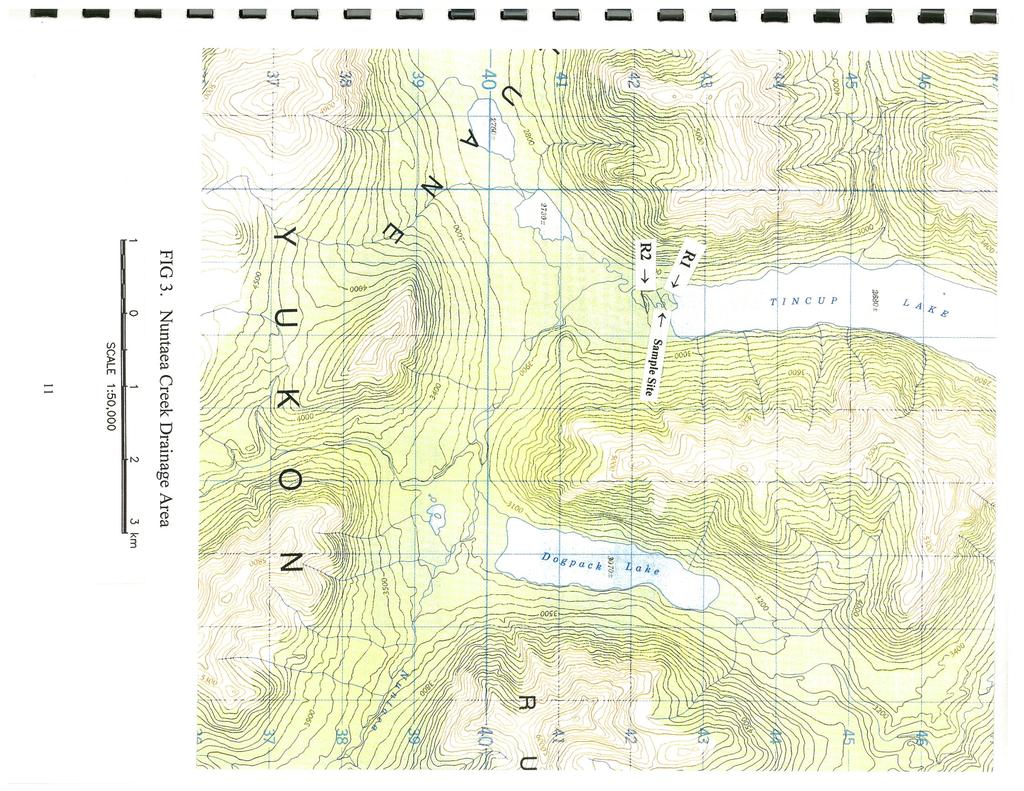
4 List of Figures Figure 1. Study Area -- Tincup Creek Drainage. 9 Figure 2.. Upper Reach of Tincup Creek Figure 3. Nuntaea Creek Drainage..11 List of Appendices Appendix 1.0 Table 1. Comparison of Physical Characteristics of Tincup Creek in Reach 1, 1998, 1999, 2000 and 2001 and Reach 2 of Nuntaea Creek, Table 2. Water Quality Parameters of Tincup and Nuntaea Creeks, Table 3. Summary of Juvenile Chinook Salmon Catch Data in Tincup Creek and Nuntaea Creek Table 4. Comparison of Juvenile Chinook Salmon Catch Data, Tincup Creek, Appendix 2.0 Juvenile Fish Collection Data, Tincup Creek, August, Appendix 3.0 Benthic Macroinvertebrates found in Tincup Creek, Reach 12, Aug. 25, ii
5 INTRODUCTION A decline in chinook salmon populations has been observed throughout the Yukon River Basin in recent times as a result of increased fishing pressure in the ocean and in the Yukon River. Further declines in the number of chinook salmon returning to spawning grounds have been observed since 1998; in fact, some of the lowest runs have been recorded since then, despite predictions of average to above average runs based on parent year escapements. It has been speculated that changes in ocean temperature regimes which occurred in 1998 have affected the ocean ecosystem and hence the ocean survival of these year classes of salmon. Corresponding declines in chinook spawning populations have been observed in the White River sub-basin of the Yukon River. Tincup Creek, a major chinook spawning creek in the White River sub-basin, once supported a chinook population large enough to sustain a native subsistence fishery (Horler, 2000). However, the number of salmon presently returning is so low that any significant subsistence fishery would seriously affect the productivity of the Tincup Creek stock. In light of declining chinook salmon returns, the Kluane First Nation (KFN) and other agencies have conducted studies with the objective of conserving and restoring salmon populations within the White River sub-basin. Studies conducted since 1995 have included enumeration surveys of chinook spawners and habitat assessments to provide baseline data which can be used in the development of an overall plan to conserve and restore salmon. This report presents the findings of investigations of Tincup Creek in 2001 including the run size and physical and biological characteristics of the habitat which have been collected since An additional component of this year's study was to investigate the possible usage of Nuntaea Creek by chinook salmon. In previous years, adult chinook have been sited at the south end of Tincup Lake near the outlet of Nuntaea Creek by KFN elders and the outfitter in this area. The destination of these chinook has not been determined. Preliminary investigations of Nuntaea Creek in 1998 indicated limited chinook salmon habitat (WMEC, 1998), however, no adult chinook salmon were observed utilizing this creek at this time and no juvenile chinook were captured in minnow traps. The extent of investigations was very limited, however, leaving the question of whether chinook salmon utilize this creek unanswered. Investigations were continued this year to determine if chinook salmon utilize Nuntaea Creek. An important component of this and previous investigations has been to provide experience for KFN members through employment in field investigations. A traditional camp located at the outlet of Tincup Lake and its proximity to the major spawning area of Tincup Creek has provided an ideal location for studying a salmon population and its environment. Funding for this project was provided by the Yukon River Panel Salmon Restoration & Enhancement Fund under the U.S./Canada Interim Agreement of the Pacific Salmon Treaty. 1
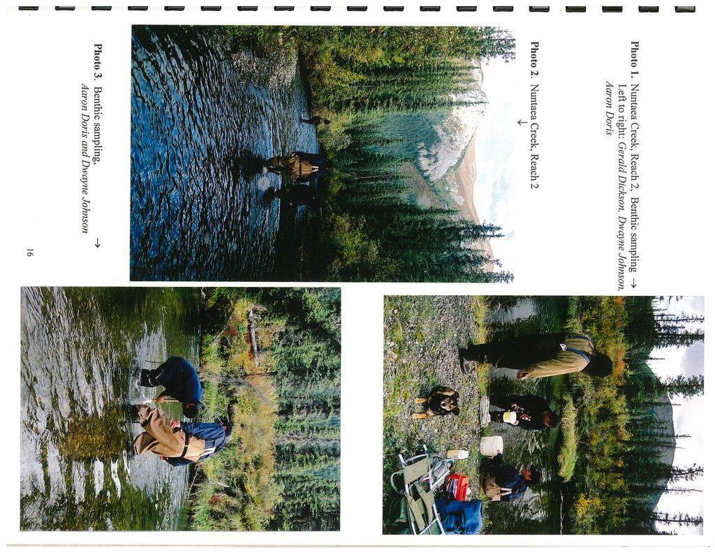
6 STUDY AREA Tincup Creek flows for about 20 km in a generally westerly direction from its headwaters at Tincup Lake (elevation 819 m) to its confluence with the Kluane River (elevation 680 m). The highest point in the drainage basin is 2,165 m. Tincup Creek and its tributaries drain an area of approximately 510 km 2 predominantly from the Ruby Ranges. Major tributaries of Tincup Creek include Nuntaea Creek, flowing from the southeast into Tincup Lake, and Swanson Creek, flowing from the north into Tincup Creek, less than 1 km upstream from the Tincup Creek-Kluane River confluence. The major lakes in the drainage basin include Tincup Lake and Dogpack Lake (Fig. 1). The drainage, which is inaccessible by road, has remained in a relative pristine state. The nearest community is Burwash Landing, located approximately 50 kilometers south of Tincup Lake. The first reach of Tincup Creek is a known spawning location for chinook salmon and has been used for generations as a traditional fishing area by KFN members. A cabin located on the north bank of the creek approximately 2 kms downstream of Tincup Lake was once used while fishing the chinook run. The reach is characterised by wide run/glides and occasional riffles with a wetted width ranging from between 10 and 30 meters. Substrates are primarily gravel/cobble with occasional boulders. Stream banks are low and sedge and grass meadows are common along the upper section of the reach. The adjacent forest is mixed black and white spruce. Most spawning occurs in a gravel riffle area approximately 1.5 km downstream of Tincup Lake. The area investigated during this study is shown in fig. 2. Nuntaea Creek is a small, clear water tributary draining mountains of the Ruby Range and Kluane Plateau at the southeast end of Tincup Lake. The watershed drains a number of small lakes, the largest being Dogpack lake, entering the creek approximately 10 kms upstream of the outlet. The creek below Dogpack Lake flows swiftly over cobbles and boulders through a relatively straight confined channel before joining a lake fed drainage from the southwest approximately 5 km downstream. The next 3.4 km of the stream meanders through the Tincup Lake valley. The section of stream is characterised by gravel/cobble substrates and riffle/run habitats. Stream banks are abrupt and rise to 2 meters. The lower 625 meters of the creek is a wide slow glide averaging 17 meters in width. Substrates are primarily sand/mud with a few areas of embedded gravel/cobble. Open sedge meadows line the banks in the vicinity of the creek outlet with a gradual transition from open white spruce, in a matrix of willow, dwarf birch and ericaceous shrubs, to spruce forest. The study area includes the lower reaches shown in fig. 3. METHODS: Fisheries investigations and habitat assessments were conducted by Kluane First Nation members, Gerald Dickson, Kirk Johnson, Edward Johnson, Billy Johnson, Shane Johnson, Dwayne Johnson, Aaron Doris and fisheries consultant, Jane Wilson. Personnel were flown in a 185 Cessna owned by Sifton Air of Haines Junction. A camp was set up at the outlet of Tincup Lake and sites were accessed by foot along a trail which follows the right bank of 2
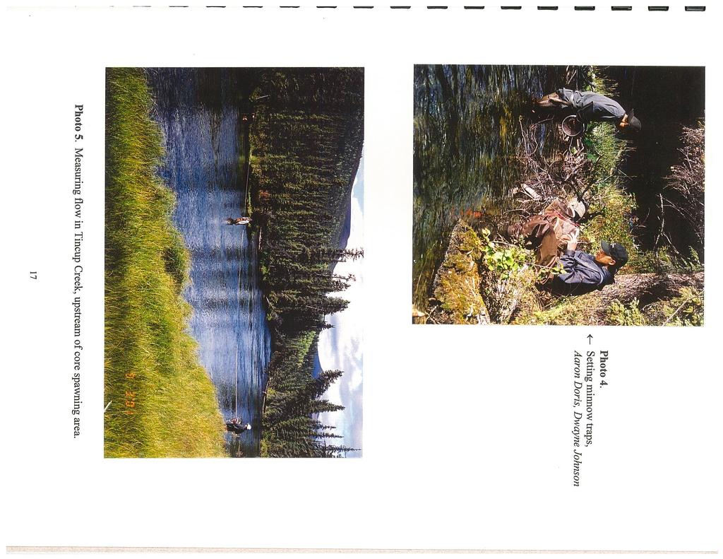
7 Tincup Creek. The south end of Tincup Lake was accessed by boat and motor. Sites along Nuntaea Creek were then accessed by foot. Fisheries assessments Fisheries assessments were undertaken through the use of various methods including: trapping, seining and visually counting above water from shore. Gee-type minnow traps with 1/4" mesh were placed in a variety of habitat types to determine the presence of juvenile chinook salmon (jcs). Traps were baited with a walnut-sized portion of Yukon River origin salmon roe suspended in a perforated plastic sandwich bag and set overnight for a minimum 12 hour period; up to a maximum of 24 hours whenever possible. A seine net (7 x 1.5 meter, 1/8" mesh) was used to detect other species of fish present. Seining was restricted to depths of less than one meter in areas where a suitable landing site was available. All juvenile fish captured were identified, enumerated and released. Jcs captured in minnow traps were anaesthetized with a small portion of an "Alka Seltzer' tablet, measured for fork length to the nearest millimeter, weighed (using a digital scale accurate to +0.1) and released after full recovery from the anaesthetic. A visual count of adult chinook salmon in the spawning area was conducted on two separate occasions. The first count was made from the right bank and the second, four days later with two people counting on either side of the creek. Analysis of fish captures The results of the trapping program were expressed as the number of fish trapped per number of hours the trap was set (CPUE). Biological data including: mean length, mean weight and mean condition factor, was determined for jcs captured. Condition factor (K) was calculated for salmon fry using the formula: K = weight(grams) x 100/[length(cm)] 3. The condition factor is used as an indicator of the general health and condition of salmonids. Benthic Sampling Benthic invertebrate samples were collected using a 30 cm D-frame invertebrate kick net sampler with a 363 micron mesh. Invertebrates were dislodged from the substrate at three locations for a total sample area of one square metre. Dislodged invertebrates and debris collected in the net held downstream of the disturbed substrate were then transferred to a one litre nalgene bottle and preserved in a 10% formalin solution. A benthic sample collected in the first reach of Tincup Creek was observed in camp to familiarize trainees with methods used to sort and identify invertebrates. This sample along with a sample from Nuntaea Creek was preserved and sent to Laberge Environmental Services in Whitehorse to be sorted, identified and enumerated. 3
8 Water Quality Basic water quality components including: temperature, ph, dissolved oxygen and conductivity were measured in-situ using a multi-parameter probe (Horiba water quality checker model U-10), calibrated prior to field operations. Velocity and discharge was determined using the floating object method in reach 1 of Tincup Creek, in approximately the same area measured in previous years (1998, 1999) and in reach 2 of Nuntaea Creek in the same area measured in 1998 (Connor,Sparling 1998). Water samples were taken from each creek for analysis of nutrients, anions and metals. Samples were collected in clean new plastic bottles at a point upstream of any disturbance associated with other site investigations. Bottles were rinsed several times with sample waters, then carefully filled to prevent contamination from external sources. Unfortunately, results of water samples were not made available due to delays in air traffic cargo the week following field studies preventing the sample from being sent to Norwest Laboratories in Surrey, B. C. for analysis. RESULTS: Juvenile Chinook Salmon (jcs) Tincup Creek A total of 10 jcs was captured in 7 minnow traps set overnight in reach 1 of Tincup Creek. The number of total trapping hours was , representing a catch per unit effort (CPUE) of The average fork length of jcs captured was 76 mm and the average weight, 5.0 g. The condition factor (K), which is used as an indicator of the general health and condition of salmonids, averaged Generally, a higher condition value is preferred to a lower value (Moodie, 1993) although no standards for comparison have yet been developed for the Yukon River system. A higher condition factor could mean greater over-wintering success. Slimy sculpins and juvenile burbot were captured incidentally in traps and in three seine sets at the outlet of Tincup Lake. Results of minnow trap catches since 1998 are presented in Appendix 1. It is assumed that jcs captured were all young-of-year (fry emerged in 2000). Although no scale samples were taken for age determination of jcs captured, weight at length comparisons of fry in Croucher Creek in the Upper Yukon River system (Moodie, 1993) indicate the general length range of young-of-year (0+) jcs to be between mm. Nuntaea Creek No jcs were captured in Nuntaea Creek in the seven traps set overnight in reaches 1 and 2. Incidental catches included slimy sculpins and one juvenile lake trout. 4
9 Adult chinook Salmon During a ground survey on September 2 a total of 39 live adult chinook salmon was observed on spawning redds in reach 1. Spawning activity appeared to be at its peak as most salmon were observed on redds in groups or pairs. By September 6, spawning activity was nearing completion with only nine live chinook remaining. A total of 21 dead chinook salmon was observed at this time, many of which had been pulled into the bush, presumably by bears. Although one adult chinook salmon was observed near the outlet of Nuntaea Creek, none were observed in the creek in the survey area between the outlet and a small unnamed headwater lake draining into Nuntaea Creek from the southwest. No observations were made above this area due to time constraints. Water Quality The water quality parameters measured in Tincup and Nuntaea Creeks indicate adequate water quality for freshwater aquatic life. Water temperatures in Nuntaea Creek were significantly cooler than Tincup Creek. A summary of water quality parameters in Tincup and Nuntaea Creeks is presented in Table 2. Stream physical characteristics measured in Tincup Creek since 1998 show water levels and flows comparable to 1999 and The velocity of flow in Nuntaea Creek was comparable to velocities recorded in Tincup Creek. The physical characteristics in Reach 1 of Tincup Creek between 1998 and 2001 are summarised in Table 1. Benthic invertebrates Analysis of the benthic samples collected indicate diverse and abundant invertebrate communities in Tincup and Nuntaea Creeks. Pollution intolerant insects including, Ephemeroptera (mayflies), Trichoptera (caddisflies) and Plecoptera (stoneflies), were well represented in the samples collected indicating good water quality (Table 3). The predominant community in Tincup Creek was comprised of Gastropods (snail). In Nuntaea Creek, Dipterans (true flies) predominated, mostly in the form of chironomid larvae (midges). These invertebrates form a valuable part of the diet of fish. DISCUSSION Tincup Creek Slightly more jcs were captured in reach 1 this year than in the previous year. It has been speculated that the high water conditions last year may have enhanced spawning and incubation success at lake outlets by providing sufficient water during the summer/autumn spawning period and during the winter by allowing lake outlets to remain open throughout the winter (von Finster, unpublished ). 5
10 Although jcs captured this year were smaller on average, their overall condition was better than those captured in 2000 as indicated by the condition factor (K). As a result of the high water conditions last year, it is possible that food energy reserves were expended on increasing the overall length of jcs to enable them to maneuver in the stronger flows. Consequently, these fish may have had fewer reserves to enable them to over-winter successfully. The number of adult chinook salmon observed in the primary spawning area in Tincup Creek was nearly double the number observed last year. In 2000, a record low number of chinook was estimated to have reached spawning grounds throughout the upper Yukon River Basin (JTC, 2000). The return this year was again expected to be low. However, surveys of index areas in other creeks and rivers in the upper Yukon River Basin conducted by DFO in 2001 indicated higher chinook salmon returns than expected (JTC, 2001). It is likely that the closure of all commercial fisheries in the Yukon River Basin during the chinook migration this year allowed more chinook salmon to reach spawning grounds. Benthic communities were more diverse and abundant than the previous year. The strong water flows during the time of sampling last year may have dislodged organisms from riffle areas where samples were collected to more protected areas (Burns, pers.comm). This year, water conditions were moderate and comparable to conditions in Nuntaea Creek Nuntaea Creek has been considered as a possible spawning destination of adult chinook salmon observed in Tincup Lake at the south end. This creek is the only tributary entering the lake of sufficient size to support a spawning population. Since lake outlets are recognized as one of the primary habitat types for spawning chinook salmon, it was speculated that spawning may occur downstream of the small lakes which drain into Nuntaea Creek. However, it remains uncertain whether fish observed in Tincup lake are utilizing Nuntaea Creek at this time as time constraints and an approaching storm, prevented investigation of the upper reaches and lake outlets. The habitat in reach 2, approximately 625 meters upstream of Tincup Lake, appears suitable for spawning. Adequate flow and suitable spawning substrate was observed throughout a this reach. However, the cold water temperatures observed in the lower reaches of Nuntaea Creek may limit utilization by chinook salmon. No juvenile chinook salmon were captured in Nuntaea Creek this year. A previous investigation (1998) of this creek failed to capture jcs as well. Nuntaea Creek is likely more suitable for species such as juvenile lake trout which are tolerant of cooler water. SUMMARY/RECOMMENDATIONS: Investigations of the biological and physical characteristics of Tincup Creek, in 2001, indicate that conditions are presently adequate for all life stages of chinook salmon. The Tincup Creek drainage area has remained essentially unaffected by human activity and has probably 6
11 changed very little from the time when ancestors of Kluane First Nation were in this area. Accounts by elders of KFN which tell of an abundance of chinook salmon in Tincup Creek at one time and the present available habitat indicate that Tincup Creek is currently capable of supporting a much higher population of chinook salmon. Careful consideration should be given to land use practices which could have potential deleterious effects on the habitat of this creek and rivers downstream. Recommendations for further study include the following: 1. Continue monitoring the chinook salmon return and the physical and biological characteristics of habitat in Tincup Creek to provide information which can be used to compare changes over time. 2. Continue to use Tincup Creek as a forum for fisheries training for KFN members 3. Initiate studies of the spawning to fry emergence stages of chinook salmon in Tincup Creek and specific spawning requirements for future restoration considerations. 4. Conduct an over-flight of lake outlets draining into Nuntaea Creek to look for potential spawning habitat and/or spawning activity. Acknowledgments The author wishes to acknowledge the contributions of the following individuals and organizations to this project: Gerald Dickson of KFN for logistical support and field crew organization; Edward Johnson, Kirk Johnson, Billy Johnson, Shane Johnson, Dwayne Johnson and Aaron Doris of Kluane First Nation for their assistance in the field; Bonnie Burns, of Laberge Environmental Services, for the analysis of benthic samples and Sonia Hansen for final preparation of maps. 7
12 References: Burns, Bonnie. October, 6, Personal Communication. Laberge Environmental Services, Whitehorse, Yukon. Connor, M., and P. Sparling Report on preliminary fisheries Investigations and training seminar in the Tincup Drainage, August White Mountain Environmental Consulting. Whitehorse, Yukon. Prepared for Kluane First Nation. Connor, M., and P. Sparling Report on fisheries investigations in the Tincup Drainage, August White Mountain Environmental Consulting. Whitehorse, Yukon. Prepared for Kluane First Nation. Moodie, S Juvenile Chinook Salmon (Onchorhynchus tshawtscha) Utilization of Croucher Creek, A Small Nonnatal Tributary of the Upper Yukon River. Yukon Conservation Society, Whitehorse, Yukon. VonFinster, Al. Notes on the possible effects of the 2000 hydrological conditions on distribution and numbers of juvenile chinook salmon during the summer of Stream Files, Fisheries & Oceans Canada, Whitehorse. 8
13
14
15
16 Table 1. Comparison of Physical Characteristics of Tincup Creek in REACH 1, 1998*,1999*, 2000 and 2001 and REACH 2 of Nuntaea Creek, Location Date Average Wetted Average Discharge (d/m/yr) Depth (m) Width (m) Velocity (m/sec)*** (m3/sec) Tincup Creek** Reach 1* 24/08/ Reach 1* 25/08/ Reach 1 31/08/ Reach 1 03/09/ Nuntaea Creek **** Reach 2 04/09/ * survey conducted by KFN and WMEC. ** measurements were taken each year at approximately the same location *** velocity was determined each year using the floating object method **** flow measurements were not determined in previous surveys Table 2. Water Quality Parameters in Tincup and Nuntaea Creeks, Location Date Water Conductivity PH Dissolved Turbidity (d/m/yr) Temp. (us/cm) Oxygen (C) (mg/l) Tincup Ck Reach 1 03/09/ Very clear Reach 2* 25/08/ Clear Reach 1 25/08/ Reach 1 24/08/ n/a 11.2 Nuntaea Ck Reach 2 05/09/ Clear Reach 2 26/08/ n/a 10.9 * water quality parameters not measured in Reach 1. Note: water quality parameters were measured in 1998 and 1999 by WMEC & KFN using a Multiline F/set-3 multimeter, and in 2000 and 2001 by Jane Wilson & KFN using A Horiba water quality checker model U-10 multi-parameter probe. 12
17 Table 3. Summary of Juvenile Chinook Salmon Catch Data in Tincup Creek (Reach 1) and Nuntaea Creek Location Date # of Traps Total CH Captured Total # Hrs Traps set CPUE* Ave. Length (mm) Length Range (mm) Ave. Weight (g) Weight Range (mm) Tincup Ck. Reach 1 04/09/ Mean K Reach 1 29/08/ Reach 1 23/08/ ** ** ** ** ** Reach 1 22/08/ ** ** ** ** ** Nuntaea Ck. Reach 1 05/09/ Reach 2 05/09/ Reach 1 26/08/ Reach 2 26/08/ * Catch per unit of effort (CPUE) = # chinook captured per hour ** no measurements taken 1.13 Table 4. Comparison of Juvenile Chinook Salmon Catch Data, Tincup Creek, Site ** Date # Traps Total CH Total # Hrs CPUE** (d/m/yr) Captured Traps Set (#CH/hour) Reach 1 23/08/ /08/ Reach 1 22/08/ Reach 1 29/08/ Reach 1 04/09/
18 Date Appendix 2. Juvenile Fish Collection Data, Tincup Creek, September Trap # # Hours Set Total CH Captured Length CH Weight CH Condition factor (K) Other Species* Trap Location (mm) (g) TINCUP Creek (Reach 1) 4-Sep BB (1) Rt. Bank,grass,undercut bank, Shallow cobble substrate 4-Sep BB (1) Lt. of small island, LOD, instream vegetation, lge.cobble/boulder 4-Sep Lt bank,between 3 boulders, grass/sedge, gravel substrate 4-Sep Island channel, streambed with SOD,good water flow 4-Sep Island channel,o.h spruce, lge cobble/boulders,good flow 4-Sep SS (1) side channel along Rt. Bank, 4-Sep good water flow, o.h. alder, 4-Sep silt/sand/cobble substrate, 4-Sep Instream vegetation, traps set 4-Sep near small island, shaded 4-Sep Sep Sep Sep Rt.Bank,under large root wad, cobble/gravel substrate, NUNTAEA Creek 5-Sep SS (1) Lt. Bank, deep pool, undercut bank, cobble substrate 5-Sep Rt. bank, LOD, undercut bank, gravel/cobble substrate 5-Sep SS (1) Lt. bank, LOD, deep pool, cobble substrate 5-Sep Lt. bank, undercut bank, gravel/mud substrate 5-Sep Lt. bank, deep pool, mud substrate, o.h. spruce 5-Sep Lt. bank, undercut bank,mud substr. 5-Sep SS (1), LT (1) Lt. Bank, mud/debris substrate, Overhanging willow 14
19 Appendix 3. Benthic Invertebrates from the Tincup Creek Area, September, Tincup Creek, Sept. 5, 2001 Taxon Number % Number % PHYLUM ARTHROPODA Class Insecta Insecta pupae Order Diptera (trueflies) Diptera larvae Diptera adult Family Chironomidae Family Tipulidae Dicranota sp Order Plecoptera (stoneflies) Plecoptera nymph Family Perlodidae Order Trichoptera (caddisflies) Trichoptera larvae Family Limnephilidae Order Ephemeroptera (mayflies) Ephemeroptera larvae Family Ephemerellidae Family Baetidae Class Arachnida Order Hydrachnidia PHYLUM ANNELIDA Class Oligochaeta PHYLUM MOLLUSCA Class Pelecypoda Family Sphaeriidae Class Gastropoda Family Planorbidae Family Lymnaeidae Radixauricularia sp Family Physidae Aplexa sp PHYLUM NEMATODA Abundance: Diversity:
20
21
Chinook Salmon Spawning Study Russian River Fall 2005
 Chinook Salmon Spawning Study Russian River Fall 2005 Sonoma County Water Agency 2150 West College Avenue Santa Rosa, California 95401 Prepared by David Cook - Senior Environmental Specialist March 27,
STREAM SURVEY File form No..
 scanned for KRIS THE RESOURCES AGENCY OF CALIFORNIA California Department of Fish and Game STREAM SURVEY File form No.. Date: September 4, 1969. NAME: North Fork Schooner Gulch Creek COUNTY: Mendocino.
Fraser River. FISH SURVEY AND MANAGEMENT INFORMATION Jon Ewert - Aquatic Biologist (Hot Sulphur Springs)
") Fraser River FISH SURVEY AND MANAGEMENT INFORMATION Jon Ewert - Aquatic Biologist (Hot Sulphur Springs) General Information: The Fraser River is a highly diverse river offering many transitions in habitat
Fraser River FISH SURVEY AND MANAGEMENT INFORMATION Jon Ewert - Aquatic Biologist (Hot Sulphur Springs) General Information: The Fraser River is a highly diverse river offering many transitions in habitat
RIVER CONONISH INVERTEBRATE SURVEY Dr Kjersti Birkeland
 RIVER CONONISH INVERTEBRATE SURVEY 26 Dr Kjersti Birkeland Background The Cononish, the upper reaches of the River Dochart, should be very important for spring salmon but surveys by the Tay District Salmon
Steelhead Society of BC. Thompson River Watershed Restoration and Enhancement Project #4 Nicola River Bank Stabilization and Enhancement Project
 Steelhead Society of BC Presents: Thompson River Watershed Restoration and Enhancement Project #4 Nicola River Bank Stabilization and Enhancement Project Application for Funding December 2013 1.0 BACKGROUND
MINISTRY OF ENVIRONMENT ENVIRONMENTAL STEWARDSHIP DIVISION FISH AND WILDLIFE BRANCH. Horsefly River Angling Management Plan
 MINISTRY OF ENVIRONMENT ENVIRONMENTAL STEWARDSHIP DIVISION FISH AND WILDLIFE BRANCH Horsefly River Angling Management Plan January 30 th, 2006 Area/Fishery Description The Horsefly River watershed provides
Fish Survey Report and Stocking Advice for Loch Milton. (Loch a Mhuilinn), May 2011
, May 2011") Fish Survey Report and Stocking Advice for Loch Milton (Loch a Mhuilinn), May 2011 Jonah Tosney Freshwater Fisheries Biologist Wester Ross Fisheries Trust 1 Loch Milton (Loch a Mhuilinn) Fish Survey Report
Fish Survey Report and Stocking Advice for Loch Milton (Loch a Mhuilinn), May 2011 Jonah Tosney Freshwater Fisheries Biologist Wester Ross Fisheries Trust 1 Loch Milton (Loch a Mhuilinn) Fish Survey Report
Data Report : Russian River Basin Steelhead and Coho Salmon Monitoring Program Pilot Study
 Data Report 1999-1: Russian River Basin Steelhead and Coho Salmon Monitoring Program Pilot Study Sonoma County Water Agency 215 West College Avenue Santa Rosa, California 951 Prepared by David Cook Senior
Minnesota Department of Natural Resources Division of Fish and Wildlife Section of Fisheries. Stream Survey Report. Luxemburg Creek.
 Minnesota F-29-R(P)-24 Area 315 Study 3 March 2016 Minnesota Department of Natural Resources Division of Fish and Wildlife Section of Fisheries Stream Survey Report Luxemburg Creek 2015 Mark Pelham Sauk
Jason Blackburn, Paul Hvenegaard, Dave Jackson, Tyler Johns, Chad Judd, Scott Seward and Juanna Thompson
 Alberta Conservation Association (ACA) Date: 2014-2015 Project Name: Owl River Walleye and Aquatic Habitat Assessment Fisheries Program Manager: Peter Aku Project Leader: Tyler Johns Primary ACA staff
FISHERIES BLUE MOUNTAINS ADAPTATION PARTNERSHIP
 FISHERIES A warming climate, by itself, substantially affects the hydrology of watersheds in the Blue Mountains. Among the key hydrologic changes projected under all scenarios for the 2040s and beyond
Winter Drawdown Issues of Concern
 Winter Drawdown Issues of Concern Wetland Connectivity Amphibians Fisheries Winter Drawdown Wetland Connectivity Wetland complex near Osprey Creek is not responsive to lake level Wetland at upper end of
Removal of natural obstructions to improve Atlantic Salmon and Brook Trout habitat in western NL. 26/02/2015 Version 2.0
 Removal of natural obstructions to improve Atlantic Salmon and Brook Trout habitat in western NL 26/02/2015 Version 2.0 1 Table of Contents List of Tables... 2 Introduction... 3 Methods... 4 Preliminary
Big Spring Creek Habitat Enhancement and Fishery Management Plans
 Big Spring Creek Habitat Enhancement and Fishery Management Plans November 5, 2012 Big Spring Events and Activities Center Newville, PA Charlie McGarrell Regional Habitat Biologist Pennsylvania Fish and
Don Pedro Project Relicensing
 Don Pedro Project Relicensing M ODESTO I RRIGATION D ISTRICT TURLOCK I RRIGATION D ISTRICT FERC PROJECT N O. 2299 Resident Fish in Don Pedro Reservoir Don Pedro Reservoir Fish Stocking (1971-Present) CDFG
2013 Electrofishing Program Summary. Miramichi Salmon Association In collaboration with the Department of Fisheries and Oceans
 2013 Electrofishing Program Summary Miramichi Salmon Association In collaboration with the Department of Fisheries and Oceans Prepared by: Alex Parker Biologist Miramichi Salmon Association 485, Route
NATIVE FISH CONSERVATION PLAN FOR THE SPRING CHINOOK SALMON ROGUE SPECIES MANAGEMENT UNIT
 Attachment 4 NATIVE FISH CONSERVATION PLAN FOR THE SPRING CHINOOK SALMON ROGUE SPECIES MANAGEMENT UNIT Figures in Draft Plan of February 28, 27 Figure 1. Map of the Rogue River Basin. PASSAGE ESTIMATES
1 INTRODUCTION AND SUMMARY
 December 10, 2012 Pacific Booker Minerals 1702 1166 Alberni Street Vancouver, British Columbia V6E 3Z3 Erik Tornquist Executive VP and COO Dear Mr. Erik Tornquist: 1 INTRODUCTION AND SUMMARY This letter
STEELHEAD SURVEYS IN OMAK CREEK
 STEELHEAD SURVEYS IN OMAK CREEK 2002 Annual Report Prepared by Chris Fisher John Arterburn Colville Confederated Tribes Fish and Wildlife Department P.O. Box 150 Nespelem, WA 99155 Prepared for Project
LIFE HISTORY DIVERSITY AND RESILIENCE
 LIFE HISTORY DIVERSITY AND RESILIENCE SPRING CHINOOK IN THE WILLAMETTE RIVER BASIN Kirk Schroeder Brian Cannon Luke Whitman Paul Olmsted Oregon Department of Fish and Wildlife Corvallis Research Lab Thanks
ELECTRO-FISHING REPORT 2016 UPPER TWEED
 ELECTRO-FISHING REPORT 2016 UPPER TWEED The electro-fishing programme carried out each summer by The Tweed Foundation is part of our management plan, which details the information that is required to manage
Rivers Inlet Salmon Initiative
 Rivers Inlet Salmon Initiative 5-YEAR BUSINESS PLAN C AS E F O R S U P P O R T M AR C H 2 0 1 5 Dedication Rick Hansen had been inspired to go to Rivers Inlet in July 2010 by his good friend, and fellow
Monitoring of Downstream Fish Passage at Cougar Dam in the South Fork McKenzie River, Oregon February 8, By Greg A.
 Monitoring of Downstream Fish Passage at Cougar Dam in the South Fork McKenzie River, Oregon 1998- February 8, 2 By Greg A. Taylor Oregon Dept. of Fish & Wildlife 315 E. Main Street Springfield, OR 97478
NORTH RIVER FISH KILL PRELIMINARY REPORT 2014 SUMMARY
 NORTH RIVER FISH KILL PRELIMINARY REPORT 2014 SUMMARY A fish kill on Nor River was reported to e 1-800 Environmental emergency number on August 9, 2014. Representatives from e PEI Department of Environment,
Lower Dolores River Corridor Planning Meeting Jim White Colorado Division of Wildlife
 Lower Dolores River Corridor Planning Meeting Jim White Colorado Division of Wildlife Objectives Overview of cold and warm water fishes in the Dolores River including: Flow and Fish Management Distribution
Study Update Fish Distribution and Species Composition
 Study Update Fish Distribution and Species Composition Goals and Study Area Gain a better understanding of fish species composition and abundance in waters associated with the Packwood Lake Hydroelectric
Elementa: Science of the Anthropocene
 Elementa: Science of the Anthropocene http://dx.doi.org/10.12952/journal.elementa.000042.s003 Figure S3. Supporting information for the article Recovery of a mining-damaged stream ecosystem by Mebane,
Study Update Tailrace Slough Use by Anadromous Salmonids
 Study Update Tailrace Slough Use by Anadromous Salmonids Goals and Objectives Identify what anadromous salmonids use the tailrace slough by: Life Stage (Juvenile, migrating and spawning adults) Timing
Freshwater Fish Assessment
 Alaska Department of Transportation & Public Facilities Seward Highway MP 7-9 6-7 Freshwater Fish Assessment March 14, 8 Prepared by HDR Alaska C Street, Suite 3 Anchorage, Alaska 993 Project Number: BR-BH-NH-OA3
Columbia Lake Dam Removal Project
 Columbia Lake Dam Removal Project The Columbia Lake dam located 1/4 mile upstream of the Paulins Kill River's confluence with the Delaware River in Knowlton Township, Warren County has been proposed for
Chinook Salmon. The Yukon River Panel
 Chinook Salmon and The Yukon River Panel Jan Conitz, ADF&G UAF FISH 493 Discussion January 26, 2016 Discussion Outline I. Yukon River context Salmon and Yukon River basics Fishing and history on the Yukon
Assessment of Elizabeth Lake as a Potential Candidate for Stocking
 Assessment of Elizabeth Lake as a Potential Candidate for Stocking Region 1, Nanaimo West Coast Planning Unit Ministry of Water, Land and Air Protection Prepared by: Laura Cassin Scott Silvestri 2002 1.0
Report prepared for: Prepared by: January 2002 BEAK Ref
 AQUATIC ENVIRONMENTAL STUDY KANATA WEST CONCEPT PLAN Report prepared for: ROBINSON CONSULTANTS Prepared by: BEAK INTERNATIONAL INCORPORATED 14 Abacus Road Brampton, Ontario L6T 5B7 January 2002 BEAK Ref.
Dissolved Oxygen in Water. Evaluation copy. Table 1. Temperature Range ( C) Trout Smallmouth bass Caddisfly larvae
 Trout Smallmouth bass Caddisfly larvae") Dissolved Oxygen in Water Computer 12A Although water is composed of oxygen and hydrogen atoms, biological life in water depends upon another form of oxygen molecular oxygen. Oxygen is used by organisms
Dissolved Oxygen in Water Computer 12A Although water is composed of oxygen and hydrogen atoms, biological life in water depends upon another form of oxygen molecular oxygen. Oxygen is used by organisms
Eastern Brook Trout Joint Venture Annual Report The Nature Conservancy 2013
 Eastern Brook Trout Joint Venture Annual Report The Nature Conservancy 2013 2013 Annual Performance Report Enhancing Connectivity in the Ash-Black Rock Sub-basin of the West Branch Narraguagus River. Project
1998 Willow Creek Downstream Migrant Trap Report. Draft. Prepared By: C. A. Walker. Lower Trinity Ranger District. Six Rivers National Forest
 1998 Willow Creek Downstream Migrant Trap Report Draft Prepared By: C. A. Walker Lower Trinity Ranger District Six Rivers National Forest September 1998 Executive Summary The downstream migrant trap was
Amendment to a Biological Assessment/Evaluation completed for the Coon Creek Land Disposal completed December Grand Valley Ranger District
 Amendment to a Biological Assessment/Evaluation completed for the Coon Creek Land Disposal completed December 2007 Grand Valley Ranger District Grand Mesa, Uncompahgre, Gunnison National Forests Prepared
Salmon and Migratol~Y Trout of the N,anaimo 'River lind Adjacent Streams (Revised 1,973)
") .. '.' ~! ~j-:-t. ~" I. This s~rie~ includes " unpublished preliminary' reports. ana Glatd rec
.. '.' ~! ~j-:-t. ~" I. This s~rie~ includes " unpublished preliminary' reports. ana Glatd rec
TABLE 1. Riverscape surveys completed in the upper Chehalis River, Newaukum, and Satsop rivers.
 RIVERSCAPE SURVEYS OF IN-STREAM FISH ASSEMBLAGES AND HABITAT IN THE CHEHALIS RIVER Mara Zimmerman and John Winkowski Washington Department of Fish and Wildlife, Fish Program EXECUTIVE SUMMARY Introduction
Abundance of Steelhead and Coho Salmon in the Lagunitas Creek Drainage, Marin County, California
 scanned for KRIS Abundance of Steelhead and Coho Salmon in the Lagunitas Creek Drainage, Marin County, California Prepared for: Marin Municipal Water District 220 Nellen Drive Corte Madera, California
6TH PELLETIER BROOK LAKE T15 R9, Aroostook Co. U.S.G.S. Gardner Pond, Maine (7 1/2 )
") 6TH PELLETIER BROOK LAKE T15 R9, Aroostook Co. U.S.G.S. Gardner Pond, Maine (7 1/2 ) Fishes Brook trout Minnows Blacknose dace Pearl dace Physical Characteristics Area - 27 acres Average depth - 2 feet
6TH PELLETIER BROOK LAKE T15 R9, Aroostook Co. U.S.G.S. Gardner Pond, Maine (7 1/2 ) Fishes Brook trout Minnows Blacknose dace Pearl dace Physical Characteristics Area - 27 acres Average depth - 2 feet
Job 1. Title: Estimate abundance of juvenile trout and salmon.
 STUDY PERFORMANCE REPORT State: Michigan Project No.: F-53-R-13 Study No.: 461 Title: Population dynamics of juvenile rainbow trout and coho salmon in Lake Superior tributaries Period Covered: April 1,
CHAPTER 4 DESIRED OUTCOMES: VISION, GOALS, AND OBJECTIVES
 CHAPTER 4 DESIRED OUTCOMES: VISION, GOALS, AND OBJECTIVES Vision One of the first steps in developing this Plan was articulating a vision - a clear statement of what the Plan strives to achieve and what
EXTENT OF OBSERVATION
 scanned for KRIS THE RESOURCES AGENCY OF CALIFORNIA Department of Fish and Game STREAM SURVEY Date: May 25 and 31, 1977. NAME: Unnamed Stream (Tributary to Sonoma Creek) COUNTY: Sonoma. STREAM SECTION:
Abundance and Run Timing of Adult Salmon in Henshaw Creek, Kanuti National Wildlife Refuge, Alaska, 2014 FRMP
 Abundance and Run Timing of Adult Salmon in Henshaw Creek, Kanuti National Wildlife Refuge, Alaska, 2014 Tanana Chiefs Conference, Fisheries Program Fairbanks, Alaska Cover Photos: Henshaw Creek Camp:
5B. Management of invasive species in the Cosumnes and Mokelumne River Basins
 5B. Management of invasive species in the Cosumnes and Mokelumne River Basins Cosumnes River The Cosumnes River basin has a number of distinct habitat types that require different management strategies
Rehabilitation of Grimes Creek, a Stream Impacted in the Past by Bucket-lined Dredge Gold Mining, Boise River Drainage, July 2008 to August 2011.
 Rehabilitation of Grimes Creek, a Stream Impacted in the Past by Bucket-lined Dredge Gold Mining, Boise River Drainage, July 2008 to August 2011. Pam Harrington TU,1020 W. Main Street Suite 440, Boise,
3. The qualification raised by the ISRP is addressed in #2 above and in the work area submittal and review by the ISRP as addressed in #1.
 Please find attached a response from The Confederated Tribes of the Warm Springs Reservation of Oregon (CTWSRO) for Project # 2008-301-00, Habitat Restoration Planning, Design and Implementation within
Collection and Analysis of Yukon River DNA Baseline Samples in Alaska and Canada-Canadian Collections 2014 CRE-78-14
 Collection and Analysis of Yukon River DNA Baseline Samples in Alaska and Canada-Canadian Collections 2014 CRE-78-14 Prepared for: The Yukon River Panel Prepared by: Treaties and Fisheries Fisheries and
The Fishery. Newfoundland Region Stock Status Report D2-05
 Fisheries Pêches and Oceans et Océans DFO Science Newfoundland Region Stock Status Report D2-05 ATLANTIC SALMON INSULAR NEWFOUNDLAND, SOUTHWEST COAST, SALMON FISHING AREAS 12-13 Background Salmon Fishing
NEVADA DEPARTMENT OF WILDLIFE STATEWIDE FISHERIES MANAGEMENT
 NEVADA DEPARTMENT OF WILDLIFE STATEWIDE FISHERIES MANAGEMENT FEDERAL AID JOB PROGRESS REPORTS F-20-52 2016 Lake Tahoe Rainbow Trout Study WESTERN REGION NEVADA DEPARTMENT OF WILDLIFE, FISHERIES DIVISION
Juvenile Steelhead and Stream Habitat Conditions Steelhead and Coho Salmon Life History Prepared by: DW ALLEY & Associates, Fishery Consultant
 Juvenile Steelhead and Stream Habitat Conditions Steelhead and Coho Salmon Life History Prepared by: DW ALLEY & Associates, Fishery Consultant I-1. Steelhead and Coho Salmon Ecology Migration. Adult steelhead
NEVADA DEPARTMENT OF WILDLIFE STATEWIDE FISHERIES MANAGEMENT
 NEVADA DEPARTMENT OF WILDLIFE STATEWIDE FISHERIES MANAGEMENT FEDERAL AID JOB PROGRESS REPORTS F-20-52 2016 REDBAND TROUT EASTERN REGION NEVADA DEPARTMENT OF WILDLIFE, FISHERIES DIVISION ANNUAL JOB PROGRESS
Redd Dewatering and Juvenile Salmonid Stranding in the Lower Feather River,
 Redd Dewatering and Juvenile Salmonid Stranding in the Lower Feather River, 2005-2006 Interim Report for NOAA Fisheries Prepared by: California Department of Water Resources Division of Environmental Services
Salmon Biology Station
 Salmon Biology Station OBJECTIVES: Students learn: Wild salmon are indicator species and keystone species whose survival is connected to the health of the watershed. o Riparian salmon need trees and trees
Michigan Department of Natural Resources Status of the Fishery Resource Report Page 1
 Michigan Department of Natural Resources 2008-59 Status of the Fishery Resource Report Page 1 Bowens Manistee County, (T24N R16W Sec. 11, 12, 13, 14, 15, 24, and 30). Last surveyed 2008 Mark A. Tonello
Yale Reservoir Kokanee (Oncorhynchus nerka) Escapement Report 2016
 Escapement Report 2016") Yale Reservoir Kokanee (Oncorhynchus nerka) Escapement Report 2016 North Fork Lewis River Hydroelectric Project Yale FERC No. 2071 Prepared by: Jeremiah Doyle, PacifiCorp April 4, 2017 1.0 INTRODUCTION
Yale Reservoir Kokanee (Oncorhynchus nerka) Escapement Report 2016 North Fork Lewis River Hydroelectric Project Yale FERC No. 2071 Prepared by: Jeremiah Doyle, PacifiCorp April 4, 2017 1.0 INTRODUCTION
Field survey of the fish populations of the lower Ngaruroro River
 Field survey of the fish populations of the lower Ngaruroro River Glenn Maclean March 2014 HBRC Publication No. 4873 Report No. RM16-54 CMB 93, RD 2, Owhango 3990 E glenn@technicallytrout.co.nz W www.technicallytrout.co.nz
WFC 50 California s Wild Vertebrates Jan. 11, Inland Waters (Lakes and Streams) Lisa Thompson
 Lisa Thompson") Inland Waters: Lakes and Streams WFC 50 11 January 2011 Lisa Thompson Fisheries Extension Specialist Wildlife, Fish, & Conservation Biology Department University of California, Davis Take home messages
Inland Waters: Lakes and Streams WFC 50 11 January 2011 Lisa Thompson Fisheries Extension Specialist Wildlife, Fish, & Conservation Biology Department University of California, Davis Take home messages
LIFE CYCLE AND COMMUNITY STRUCTURE OF CADDISFLIES (INSECTA:TRICHOPTERA) IN THE NAVASOTA RIVER, TEXAS.
 IN THE NAVASOTA RIVER, TEXAS.") LIFE CYCLE AND COMMUNITY STRUCTURE OF CADDISFLIES (INSECTA:TRICHOPTERA) IN THE NAVASOTA RIVER, TEXAS. An Undergraduate Research Scholars Thesis by SARAH PRUSKI Submitted to Honors and Undergraduate Research
LIFE CYCLE AND COMMUNITY STRUCTURE OF CADDISFLIES (INSECTA:TRICHOPTERA) IN THE NAVASOTA RIVER, TEXAS. An Undergraduate Research Scholars Thesis by SARAH PRUSKI Submitted to Honors and Undergraduate Research
FINAL REPORT. Yonkers Creek Migration Barrier Removal Project Wonderstump Road Del Norte County. Submitted By:
 FINAL REPORT Yonkers Creek Migration Barrier Removal Project Wonderstump Road Del Norte County Submitted By: Del Norte County Community Development Department Yonkers Creek Migration Barrier Removal Project
REC 6 FISHERIES HABITAT EVALUATION
 REC 6 FISHERIES HABITAT EVALUATION 1.0 EXECUTIVE SUMMARY Analysis of fisheries habitat for recreational angling opportunities was completed by reviewing the results of the CAWG 1, Characterize Stream and
Executive Summary. Map 1. The Santa Clara River watershed with topography.
 Santa Clara River Steelhead Trout: Assessment and Recovery Opportunities December 2005 Prepared By: Matt Stoecker and Elise Kelley, Ph.D. University of California, Santa Barbara Prepared For: The Santa
Columbia Lake Dam Removal Project
 Columbia Lake Dam Removal Project Major Goals of the Columbia Lake Dam Removal: Reconnect 10 miles of the Paulins Kill River to the Delaware River, restoring natural flow regime and sediment transport.
COA-F17-F-1343 YEAR END REPORT
 DAVE MARSHALL SALMON RESERVE RESTORATION, MAINTENANCE, AND UPGRADES YEAR END REPORT Prepared for: Fish and Wildlife Compensation Program Prepared by: Edith Tobe, RPBio, Executive Director Box 1791, Squamish,
Trip Report: Eagle Creek, Arizona
 Trip Report: Eagle Creek, Arizona 15-17 June 2009 Participants: Abraham Karam, Brian Kesner, and Mike Childs Native Fish Lab Marsh & Associates, LLC 5016 South Ash Avenue Suite 108 Tempe, Arizona 85282
Minnesota Department of Natural Resources Fisheries Division, Lake Superior Area
 Minnesota F-9-R(P)- Study 4 Job 616 Minnesota Department of Natural Resources Fisheries Division, Lake Superior Area Coaster Brook Trout Status in Minnesota-Lake Superior Tributaries Following Regulation
Brook Trout Life Cycle and Habitat
 Brook Trout Life Cycle and Habitat Directions: 1. As you watch this slide show, watch for vocabulary terms we learned today. The first time they appear, you will see them in RED! (not redd!) 2. At the
Fish Habitat Restoration and Monitoring in Southeast Washington. Andy Hill Eco Logical Research, Inc.
 Fish Habitat Restoration and Monitoring in Southeast Washington Andy Hill Eco Logical Research, Inc. Fish Habitat Restoration and Monitoring in Southeast Washington Talk overview: Restoration projects
Firth Creek Habitat Enhancement Project 1993
 Firth Creek Habitat Enhancement Project 1993 A. R. Langston December 1993 PWFWCP Report No. 77 The Peace/Williston Fish & Wildlife Compensation Program is a cooperative venture of BC Hydro and the provincial
Notebooks or journals for drawing and taking notes
 Title: Have to Have a Habitat Grade Level: 5 th -8 th grade Topic: Trout Habitat Background: The following chart lists the ideal conditions for trout habitat. Dissolved Oxygen: > 7 mg/l ph: 5.5-7 Next
Study 9.5 Fish Distribution and Abundance in the Upper Susitna River
 Initial Study Report Meeting Study 9.5 Fish Distribution and Abundance in the Upper Susitna River October 15, 2014 Prepared by R2 Resource Consultants, Inc. 10/15/2014 1 Study 9.5 Objectives 1. Describe
Executive Summary Gantahaz Lake 2006
 Executive Summary Gantahaz Lake 2006 A stocking assessment was conducted at Gantahaz Lake on September 29, 2006. This was the third assessment completed since the inception of stocking in 1976. The management
Illinois Lake Management Association Conference March 23, 2018 By Trent Thomas Illinois Department of Natural Resources Division of Fisheries
 Illinois Lake Management Association Conference March 23, 2018 By Trent Thomas Illinois Department of Natural Resources Division of Fisheries Sources of Habitat Impairment Sedimentation Channelization
Lake Chelan Kokanee Spawning Ground Surveys 2012 Final Report
 Lake Chelan Kokanee Spawning Ground Surveys 2012 Final Report Spawning kokanee (Oncorhynchus nerka) in Company Creek Chelan County PUD, 2005. (Photo by Brad Buchsieb) Prepared by: Barry G. Keesee And Lance
1.Mill Creek Watershed Summary Description and Land Use
 1.Mill Creek Watershed Summary Description and Land Use Table xxx: Mill Creek Watershed Overview Watershed Size 31,435 acres/49.1 sq miles/ 127.1 sq km Elevation Range 5,594 feet [4,967-10,561] Stream
Alberta Conservation Association 2017/18 Project Summary Report
 Alberta Conservation Association 2017/18 Project Summary Report Project Name: Abundance, Distribution, Spawning, and Thermal Habitat of Westslope Cutthroat Trout and Bull Trout in the Stimson Creek Watershed
The Blue Heron Slough Conservation Bank
 1 The Blue Heron Slough Conservation Bank CONSERVATION BANKING July 19-23, 2010 CASE STUDY SERIES The Blue Heron Slough Conservation Bank (Washington) I. OVERVIEW & BACKGROUND: Location: Snohomish River
Final Bull Trout Genetics Monitoring Plan for the Wallowa Falls Hydroelectric Project. (FERC No. P-308) June 2017
 June 2017") Final for the Wallowa Falls Hydroelectric Project (FERC No. P-308) June 2017 Prepared by: Jeremiah Doyle PacifiCorp 825 NE Multnomah Street Portland, OR 97232 June, 2017 Page 1 of 8 Table of Contents 1.0
Final for the Wallowa Falls Hydroelectric Project (FERC No. P-308) June 2017 Prepared by: Jeremiah Doyle PacifiCorp 825 NE Multnomah Street Portland, OR 97232 June, 2017 Page 1 of 8 Table of Contents 1.0
DECEMBER 2003 Instream habitat assessment for the Waikanae River
 DECEMBER 3 Instream habitat assessment for the Waikanae River Laura Watts Resource Investigations Department Executive Summary An instream habitat investigation of the Waikanae River was performed to assess
2009 YUKON RIVER NORTH MAINSTEM STEWARDSHIP
 2009 YUKON RIVER NORTH MAINSTEM STEWARDSHIP Prepared by: Liz Fraser Executive Secretariat DDRRC Yukon River North Mainstem Stewardship [CRE-06-09] October 2009 Prepared By: Liz Fraser DDRRC Prepared for:
The Effects of Stream Adjacent Logging on Downstream Populations of Coastal Cutthroat Trout
 The Effects of Stream Adjacent Logging on Downstream Populations of Coastal Cutthroat Trout. D. S. Bateman 1, R.E. Gresswell 2, Aaron M. Berger 3, D.P. Hockman-Wert 4 and D.W. Leer 1 1 Department of Forest
Striped Bass and White Hybrid (x) Striped Bass Management and Fishing in Pennsylvania
 Striped Bass Management and Fishing in Pennsylvania") Striped Bass and White Hybrid (x) Striped Bass Management and Fishing in Pennsylvania Prepared by R. Lorantas, D. Kristine and C. Hobbs PFBC Warmwater Unit 2005 (stocking numbers updated after 2005) Goal:
Striped Bass and White Hybrid (x) Striped Bass Management and Fishing in Pennsylvania Prepared by R. Lorantas, D. Kristine and C. Hobbs PFBC Warmwater Unit 2005 (stocking numbers updated after 2005) Goal:
Clowhom Project Water Use Plan
 Clowhom Project Water Use Plan Fish Productivity Monitoring Implementation Year 4 Reference: COMMON-2 Fish Productivity Monitoring Year 4 Data Summary 2010 Study Period: September 16 to October 6, 2010
Manual of Fisheries Survey Methods II: with periodic updates. Chapter 22: Guidelines for Sampling Warmwater Rivers with Rotenone
 Manual of Fisheries Survey Methods II: with periodic updates : Guidelines for Sampling Warmwater Rivers with Rotenone P. W. Seelbach, G. L. Towns, and D. D. Nelson Suggested citation: Seelbach, Paul W.,
FISH POPULATION AND RIVERINE HABITAT INVENTORY OF THE ELK RIVER, SPARWOOD, BRITISH COLUMBIA
 FISH POPULATION AND RIVERINE HABITAT INVENTORY OF THE ELK RIVER, SPARWOOD, BRITISH COLUMBIA Submitted to: UMA Engineering Ltd. Calgary Alberta Submitted by: Applied Aquatic Research Ltd. Calgary, Alberta
FISH PASSAGE IMPROVEMENT in California s Watersheds. Assessments & Recommendations by the Fish Passage Forum
 FISH PASSAGE IMPROVEMENT in California s Watersheds Assessments & Recommendations by the Fish Passage Forum FISH PASSAGE IMPROVEMENT in California s Watersheds The mission of the Fish Passage Forum is
Hydraulic Modeling of Stream Enhancement Methods
 Hydraulic Modeling of Stream Enhancement Methods Matthew J. Curry John J. Levitsky Abstract Development within watersheds increases the amounts of runoff causing stream erosion and degradation of stream
Fish Passage Culvert Assessment for Cahilty Creek Watershed FIA Project #
 Fish Passage Culvert Assessment for Cahilty Creek Watershed FIA Project # 4602004 Prepared for Weyerhaeuser Company Ltd. Jason Ladyman R.P.F. 1550 Mission Flats Road PO Box 40 Kamloops BC V2C 5K3 Prepared
Minnesota Department of Natural Resources Division of Fish and Wildlife Section of Fisheries. Stream Survey Report. Cold Spring Creek.
 Minnesota F-29-R(P)-24 Area 315 Study 3 March 2013 Minnesota Department of Natural Resources Division of Fish and Wildlife Section of Fisheries Stream Survey Report Cold Spring Creek 2012 Mark Pelham Montrose
During the mid-to-late 1980s
 The 2001 Yellow Perch Report by Rick Kubb During the mid-to-late 1980s the yellow perch popula tions in Lake Erie were among the highest on record. Limit catches by fishermen were extremely common during
Blue Creek Chinook Outmigration Monitoring Technical Memorandum
 Blue Creek Chinook Outmigration Monitoring 2012 Technical Memorandum Prepared by: Andrew Antonetti and Erika Partee Yurok Tribe Fisheries Program PO Box 1027 Klamath, California 95548 In Partnership with:
COLORADO RIVER RECOVERY PROGRAM RECOVERY PROGRAM FY 2015 ANNUAL PROJECT REPORT PROJECT NUMBER: 160
 COLORADO RIVER RECOVERY PROGRAM RECOVERY PROGRAM FY 215 ANNUAL PROJECT REPORT PROJECT NUMBER: 16 I. Project Title: Assessment of Stocked Razorback Sucker Reproduction in the Lower Green and Lower Colorado
Juvenile Salmon Use of Knik Arm Estuaries. Hannah N. Ramage
 Juvenile Salmon Use of Knik Arm Estuaries Hannah N. Ramage Literature Review Function of estuaries for juvenile salmon Migration pathway Pink salmon use estuaries as a neutral pathway (Simenstad 1982)
ATLANTIC SALMON NEWFOUNDLAND AND LABRADOR, SALMON FISHING AREAS 1-14B. The Fisheries. Newfoundland Region Stock Status Report D2-01
 Fisheries Pêches and Oceans et Océans DFO Science Newfoundland Region Stock Status Report D2-01 ATLANTIC SALMON NEWFOUNDLAND AND LABRADOR, SALMON FISHING AREAS 1-14B Background There are 15 Atlantic salmon
South Fork Chehalis Watershed Culvert Assessment
 South Fork Chehalis Watershed Culvert Assessment Water Resource Inventory Area 23 Lewis County Conservation District Final Report By: Kelly Verd and Nikki Wilson March 2003 Funded by: The Washington State
Clowhom Project Water Use Plan. Fish Productivity Monitoring. Reference: COMMON-2. Fish Productivity Monitoring Year 2 Data Summary 2008
 Clowhom Project Water Use Plan Fish Productivity Monitoring Reference: COMMON-2 Fish Productivity Monitoring Year 2 Data Summary 2008 Study Period: August 25 to October 16, 2008 D.J. Bates Resource Management
Project Name: Distribution and Abundance of the Migratory Bull Trout Population in the Castle River Drainage (Year 4 of 4)
") Alberta Conservation Association (ACA) Date: 2014-2015 Project Name: Distribution and Abundance of the Migratory Bull Trout Population in the Castle River Drainage (Year 4 of 4) Fisheries Program Manager:
Alberta Conservation Association (ACA) Date: 2014-2015 Project Name: Distribution and Abundance of the Migratory Bull Trout Population in the Castle River Drainage (Year 4 of 4) Fisheries Program Manager:
Dauphin Lake Fishery. Status of Walleye Stocks and Conservation Measures
 Dauphin Lake Fishery Status of Walleye Stocks and Conservation Measures Date: December, 21 Dauphin Lake Fishery Status of Walleye Stocks and Conservation Measures Background: Walleye stocks in Dauphin
THE RESOURCES AGENCY OF CALIFORNIA Department of Fish and Game STREAM SURVEY
 File form No.. Date: 4/1/73. NAME: Maacama Creek COUNTY: Sonoma. STREAM SECTION: FROM: Maacama Creek Ranch TO: Chalk Hill Rd. Bridge LENGTH: 1.5 mi.. Bridge OTHER NAMES: Weather - Clear & Sunny RIVER SYSTEM: