Stillwater Status Report: Enagh Lough East
|
|
|
- Julie Phelps
- 5 years ago
- Views:
Transcription


1 LOUGHS AGENCY OF THE FOYLE CARLINGFORD AND IRISH LIGHTS COMMISSION Stillwater Status Report: Enagh Lough East Stillwater Fish Stock Survey Loughs Agency of the Foyle Carlingford and Irish Lights Commission Art Niven & Mark McCauley March 2017 A lake fish stock assessment was conducted to record indicative species composition and abundance of Enagh Lough East during the summer of 2016.
42 938 3888 Fax+353(0)42 938 3888 c a r l i n g f o r d @ l o u g h s - a g e n c y.")
2 Headquarters 22, Victoria Road Derry~Londonderry BT47 2AB Northern Ireland Tel: +44(0) Fax: +44(0) g e n e r a l o u g h s - a g e n c y. o r g w w w. l o u g h s - a g e n c y. o r g Regional Office Dundalk Street Carlingford Co Louth Republic of Ireland Tel+353(0) Fax+353(0) c a r l i n g f o r l o u g h s - a g e n c y. o r g w w w. l o u g h s - a g e n c y. o r g Report Reference LA/Lake/08/17 CITATION: Niven, A.J. & McCauley, M. (2017) Stillwater Status Report: Enagh Lough East. Loughs Agency, 22, Victoria Road, Derry~Londonderry Page 2 of 32
3 DOCUMENT CONTROL Name of Document Stillwater Status Report: Enagh Lough East Author (s): Art Niven & Mark McCauley Authorised Officer: John McCartney Description of Content: Approved by: Stillwater Fish Stock Assessment John McCartney Date of Approval: March 2017 Assigned review period: 5 Years Date of next review: March 2021 Document Code This documents comprises LA/LAKE/09/17 TOC Text List of tables Table of Figures X X X X No. Appendices Version Control Table Version No. Status Author (s) Reviewed by Approved by Date of issue Version 1 Draft Art Niven M. McCauley John McCartney John McCartney March 2021 Revision 2 Revision 3 Version 3 Page 3 of 32
4 TABLE OF CONTENTS TABLE OF CONTENTS... 4 ACKNOWLEDGEMENTS... 7 PROJECT STAFF EXECUTIVE SUMMARY INTRODUCTION... 9 Fig 1. Stillwater Fish Survey on Enagh Lough East, BATHYMETRY SURVEY... 9 Fig 2. Echo sounder recording data points during the bathymetry survey of Enagh Lough East Fig 3. Enagh Lough East with transects and GPS Fig 4. Enagh Lough East bathymetric map METHODS Fig 5. Details of survey nets deployed on Enagh Lough East Fig 6. Nets being prepared at Loughs Agency headquarters for survey on Enagh Lough East Fig 7. Enagh Lough East bathymetry map overlaid on 50m grid squares.. 15 Fig 8. The precise location of each net was recorded using a handheld Trimble Geo HT GPS RESULTS SPECIES RICHNESS Fig 9. Number of each species captured by each gear type during the survey of Enagh Lough East, FISH ABUNDANCE Fig 10. Mean (± S.E.) CPUE and BPUE for all fish species recorded on Enagh Lough East, Fig 11. Gill net being hauled on Enagh Lough East, Page 4 of 32
5 Fig 12. Mean (± S.E.) CPUE for all fish species captured in Enagh Lough East 2016 (Eel CPUE based on Fyke nets only) Fig 13. Mean (± S.E.) BPUE for all fish species captured in Enagh Lough East 2016 (Eel BPUE based on Fyke nets only) PIKE STOCK DENSITY & POPULATION STRUCTURE Fig 14. Mean CPUE for all Pike captured in Lough Mourne 2010, Lough Muck 2011, Camlough 2016 and Enagh Lough East Fig 15. Mean BPUE for all Pike captured in Lough Mourne 2010, Lough Muck 2011, Camlough 2016 and Enagh Lough East Fig 16. Length frequency Pike, Enagh Lough East 2016 (N=4) ROACH STOCK DENSITY & POPULATION STRUCTURE Fig 17. Mean CPUE for all Roach captured in Lough Mourne 2010, Lough Muck 2011, Camlough 2016 and Enagh Lough East Fig 18. Mean BPUE for all Roach captured in Lough Mourne 2010, Lough Muck 2011, Camlough 2016 and Enagh Lough East Fig 19. Length frequency Roach, Enagh Lough East 2016 (N=302) PERCH STOCK DENSITY & POPULATION STRUCTURE Fig 20. Mean CPUE for all Perch captured in Lough Muck 2011, Camlough 2016 and Enagh Lough East Fig 21. Mean BPUE for all Perch captured in Lough Muck 2011, Camlough 2016 and Enagh Lough East Fig 22. Length frequency Perch, Enagh Lough East 2016 (N=300) EEL STOCK DENSITY & POPULATION STRUCTURE Fig 23. Mean CPUE for all Eels captured in Lough Mourne 2010, Lough Carn 2010, Lough Muck 2012, Lough Nambraddan 2014, Camlough 2016, Enagh East 2016 and Lough Trusk Fig 24. Mean BPUE for all Eels captured in Lough Mourne 2010, Lough Carn 2010, Lough Muck 2012, Lough Nambraddan 2014, Camlough 2016, Enagh East 2016 and Lough Trusk Fig 25. Eel mean length and mean weight comparison for lakes surveyed Page 5 of 32
6 4.7 FISH AGE AND GROWTH Fig 26. Comparison growth curve showing back calculated length at age for Roach, Enagh Lough East and Camlough Fig 27. Comparison growth curve showing back calculated length at age for Perch, Enagh Lough East and Camlough DISCUSSION INVASIVE SPECIES BIOSECURITY RECOMMENDATIONS REFERENCES This document and its contents are copyright of the Loughs Agency 2017 Page 6 of 32

 and the lease holder of the fishery (Strathfoyle")


7 ACKNOWLEDGEMENTS The Loughs Agency sponsoring departments, board and staff are gratefully acknowledged for the funding, support and assistance provided to conduct stillwater fish stock assessments and status reporting in the Foyle and Carlingford areas. The Fishery owners (The Honourable the Irish Society) and the lease holder of the fishery (Strathfoyle Community Development Association) are also gratefully acknowledged for their co-operation. PROJECT STAFF 2016 Fisheries Biologist/Project Manager Assistant Scientific Officer GIS Manager Fisheries Intern Fisheries Intern Art Niven Mark McCauley Rachel Scott Dineka Maguire Seanan Maguire For further information Loughs Agency TV LOUGHS AGENCY OF THE FOYLE CARLINGFORD AND IRISH LIGHTS COMMISSION 2017 Page 7 of 32
8 EXECUTIVE SUMMARY A Water Framework Directive compliant stillwater fish stock assessment was carried out on Enagh Lough East in September The Loughs Agency commenced a small rolling programme of lake fish surveys in 2010 to gain a better understanding of fish composition and abundance of the standing waterbodies within the Foyle and Carlingford areas. The information collected can be used to derive a formal Water Framework Directive classification, a baseline survey for use in the scrutiny of any future development proposals or for contributing towards the sustainable development of the angling amenity. Enagh Lough East is situated approximately 4km north east of Derry~Londonderry. Enagh Lough East was selected as no previous baseline scientific fisheries survey had been conducted on the lough and no accurate depth (bathymetry) data was available. In order to be able to follow the WFD survey methodology it was necessary to complete a bathymetric survey prior to the commencement of the lake fish survey. A stocked Rainbow trout and Pike fishery is operated on the adjacent Enagh Lough West, the two lakes are approximately 200 metres apart. The 2016 fish stock assessment noted the presence of several fish species in Enagh Lough East including Pike, European eel, Roach, and Perch with a total of 607 individual fish captured during the survey. Roach (Rutilus rutilus) and Perch (Perca fluviatilis) were by far the most common fish species encountered as demonstrated by the similar catch per unit effort recorded for both species. This is the first scientific lake survey report on Enagh Lough East and provides a baseline survey of species and their relative abundance to fishery managers and anglers alike. It is anticipated that this survey report could significantly contribute towards any future sustainable development of angling initiatives, infrastructure or development plans for the lough, and provide the basis for an evidence based approach to the management of the lough. If access to the Fish in Lakes 2 Water Framework Directive classification tool was available a WFD compliant classification could also be derived for Enagh Lough Page 8 of 32


9 East and provided to the Northern Ireland Environment Agency for national reporting purposes. 1.0 INTRODUCTION Enagh Lough East is located approximately 4km north east of Derry City, in the Foyle catchment. The lake is located at an altitude of approximately 20 metres above sea level and its principal dimensions are; Length: 550m long, maximum width 450 metres Surface area: 13.7 hectares Maximum depth: 10 metres Fig 1. Stillwater Fish Survey being carried out on Enagh Lough East, BATHYMETRY SURVEY Prior to the lake fish survey being carried out it was essential to obtain accurate depth data for the lake. It is a prerequisite of any WFD compliant lake fish survey Page 9 of 32
. The area of the lake (ha) and the maximum depth are used to determine the distribution and number of gill nets required for the survey.")

10 to have detailed bathymetry data, so that the survey can be carried out in accordance with the standard sampling methods for the assessment of ecological status in freshwater lakes across the island of Ireland (Eco-region 17). The area of the lake (ha) and the maximum depth are used to determine the distribution and number of gill nets required for the survey. A Midas Surveyor, integrated echo sounder, GPS and data logger was used to collect raw depth data linked to a geographical location. This logged data was then used to produce a lake bathymetric chart. The echo sounder transducer was secured to a pole which was then attached to the gunnel of the survey boat using a clamp. The transducer was positioned below the surface of the water with the GPS antennae attached to the top of the pole. Both were connected by cables to the echo sounder logging unit. The bathymetry survey consisted of covering transects of approximately 20m spacing across the lough. Depth and location were recorded at a resolution of three records per second. The raw data was downloaded from the echo sounder back in the office and imported into ArcMap 10. The data points were then extrapolated to produce an overall bathymetry map for Enagh Lough East. Fig 2. Echo sounder recording data points during the bathymetry survey of Enagh Lough East. Page 10 of 32


11 Fig 3. Enagh Lough East with transects and GPS Page 11 of 32


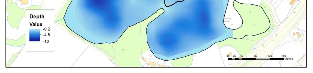
12 Fig 4. Enagh Lough East bathymetric map Page 12 of 32
. A total of 11 nets were set as summarised in Figure 5 below. Net type No.")

13 3.0 METHODS Enagh Lough East was surveyed over one night from the 13 th of September 2016 according to the methodology described in the Water Framework Directive compliant NS Share Methods Manual for systematic surveying of lakes for fish (NSSHARE, 2008). A total of 11 nets were set as summarised in Figure 5 below. Net type No. Deployed Water depth (m) Dutch fyke nets (chain of 3) Multi-mesh gill nets Multi-mesh gill nets Multi-mesh gill nets Multi-mesh floating nets Fig 5. Details of survey nets deployed on Enagh Lough East. Fig 6. Nets being prepared at Loughs Agency headquarters for survey on Enagh Lough East. Page 13 of 32

.")


14 Survey locations were chosen within randomly selected 50m X 50m grid squares overlaid on a bathymetric map of the lough (Figure 7). The location and depth of each net is also shown. A handheld Trimble Geo HT GPS was used to record the precise location of each net (Figure 8). Any fish which were alive and in good condition were measured and released live after removal from the nets, this included all eels. All other fish were removed from the nets and identified and measured at Loughs Agency headquarters. Page 14 of 32


15 Fig 7. Enagh Lough East bathymetry map overlaid on 50m grid squares. Page 15 of 32


16 Fig 8. The precise location of each net was recorded using a handheld Trimble Geo HT GPS. Page 16 of 32
 were the most common fish species encountered in the benthic gill nets.")
17 4.0 RESULTS 4.1 SPECIES RICHNESS A total of four fish species were recorded on Enagh Lough East in September 2016 with a total of 607 fish captured during the survey. A list of species encountered and captured by each gear type is compiled in Figure 9. Roach (Rutilus rutilus) were the most common fish species encountered in the benthic gill nets. One European eel was caught in the fyke nets. Common name Scientific name Benthic gill nets Fyke nets Total Pike Esox lucius Roach Rutilus rutilus Perch Perca fluviatilis Eel Anguilla anguilla Fig 9. Number of each species captured by each gear type during the survey of Enagh Lough East, FISH ABUNDANCE Fish abundance, mean catch per unit effort (CPUE) was calculated as the mean number of fish caught per metre of net. Fish biomass, mean biomass per unit effort (BPUE) was calculated as the mean weight of fish caught per metre of net. For all fish species with the exception of eels CPUE/BPUE is based on all nets including fyke nets. For all eels CPUE/BPUE is based on fyke nets only. Weights were not available from those fish which were released alive. In such cases weights were calculated from the length weight relationship of recorded fish. A summary of CPUE and BPUE data for each species is shown in Figure 10. Page 17 of 32
 2.87 (1.")
 Fig 10. Mean (± S.E.) CPUE and BPUE for all fish species recorded on Enagh Lough East, 2016. Fig 11.")
18 Roach were the dominant fish species in terms of abundance although they were only very marginally more abundant than Perch. Perch were by far the dominant species in term of biomass. Common name Scientific name 2016 CPUE 2016 BPUE Pike Esox lucius (0.005) 2.87 (1.407) Roach Rutilus rutilus (0.489) (3.894) Perch Perca fluviatilis (0.401) (6.557) Eel Anguilla anguilla (0.011) (8.001) Fig 10. Mean (± S.E.) CPUE and BPUE for all fish species recorded on Enagh Lough East, Fig 11. Gill net being hauled on Enagh Lough East, Page 18 of 32
19 CPUE (Number of fish/m net) Pike Roach Species Perch Eel Fig 12. Mean (± S.E.) CPUE for all fish species captured in Enagh Lough East 2016 (Eel CPUE based on Fyke nets only). 25 BPUE (Mean biomass (g) of fish/m net) Pike Roach Species Perch Eel Fig 13. Mean (± S.E.) BPUE for all fish species captured in Enagh Lough East 2016 (Eel BPUE based on Fyke nets only). Page 19 of 32
20 4.3 PIKE STOCK DENSITY & POPULATION STRUCTURE The relative density (CPUE & BPUE) and length frequency distribution of Pike is presented below. Values are also compared with other lakes which have been surveyed within the Foyle and Carlingford areas. A total of 4 Pike were recorded during the Enagh Lough East survey, lengths ranged from 190mm to 371mm (mean length 313mm). The abundance of Pike in Enagh Lough East is slightly less than other surveyed loughs. 9 Pike were recorded in Lough Mourne 2010, lengths ranged from 195mm to 316mm (mean length 279mm). 6 Pike were recorded in Lough Muck 2011 (Tyrone), lengths ranged from 365mm to 610mm (mean length 464mm). 2 Pike were recorded in Camlough 2016, lengths ranged from 593mm to 602mm (mean length 598mm) CPUE (Number of fish/m net) Lough Mourne 2010 Lough Muck 2011 (Tyrone) Site Camlough 2016 Enagh Lough East 2016 Fig 14. Mean CPUE for all Pike captured in Lough Mourne 2010, Lough Muck 2011, Camlough 2016 and Enagh Lough East Page 20 of 32
21 18 BPUE (Mean biomass (g) of fish/m net) Lough Mourne 2010 Lough Muck 2011 (Tyrone) Site Camlough 2016 Enagh Lough East 2016 Fig 15. Mean BPUE for all Pike captured in Lough Mourne 2010, Lough Muck 2011, Camlough 2016 and Enagh Lough East Frequency Length (mm) Fig 16. Length frequency Pike, Enagh Lough East 2016 (N=4). Page 21 of 32
22 4.4 ROACH STOCK DENSITY & POPULATION STRUCTURE The relative density (CPUE & BPUE) and length frequency distribution of Roach is presented below. Values are also compared with other lakes which have been surveyed within the Foyle and Carlingford areas. A total of 302 Roach were recorded in Enagh Lough East, lengths ranged from 50mm to 291mm (mean length 86mm). The abundance of Roach in Enagh Lough East compares favourably with other surveyed loughs although in terms of biomass these fish tend to be smaller in comparison. 208 Roach were recorded in Lough Mourne 2010, lengths ranged from 50mm to 280mm (mean length 126mm). 96 Roach were recorded in Lough Muck 2011, lengths ranged from 110mm to 260mm (mean length 176mm). 605 Roach were recorded in Camlough 2016, lengths ranged from 58mm to 294mm (mean length 99mm) CPUE (Number of fish/m net) Lough Mourne 2010 Lough Muck 2011 (Tyrone) Site Camlough 2016 Enagh Lough East 2016 Fig 17. Mean CPUE for all Roach captured in Lough Mourne 2010, Lough Muck 2011, Camlough 2016 and Enagh Lough East Page 22 of 32
23 45 40 BPUE (Mean biomass (g) of fish/m net) Lough Mourne 2010 Lough Muck 2011 (Tyrone) Camlough 2016 Enagh Lough East 2016 Site Fig 18. Mean BPUE for all Roach captured in Lough Mourne 2010, Lough Muck 2011, Camlough 2016 and Enagh Lough East Frequency Length (mm) Fig 19. Length frequency Roach, Enagh Lough East 2016 (N=302) Page 23 of 32
24 4.5 PERCH STOCK DENSITY & POPULATION STRUCTURE The relative density (CPUE & BPUE) and length frequency distribution of Perch is presented below. Values are also compared with other lakes which have been surveyed within the Foyle and Carlingford areas. A total of 300 Perch were recorded in Enagh Lough East in 2016, lengths ranged from 50mm to 287mm (mean length 88mm). The abundance of Perch in Enagh Lough East is slightly higher than other surveyed loughs and the biomass of fish caught is almost identical in comparison. 194 Perch were recorded in Lough Muck 2011, lengths ranged from 43mm to 330mm (mean length 113mm). 417 Perch were recorded in Camlough, lengths ranged from 56mm to 255mm (mean length 110mm) CPUE (Number of fish/m net) Lough Muck 2011 (Tyrone) Camlough 2016 Enagh Lough East 2016 Site Fig 20. Mean CPUE for all Perch captured in Lough Muck 2011, Camlough 2016 and Enagh Lough East Page 24 of 32
25 20 BPUE (Mean biomass (g) of fish/m net) Lough Muck 2011 (Tyrone) Camlough 2016 Enagh Lough East 2016 Site Fig 21. Mean BPUE for all Perch captured in Lough Muck 2011, Camlough 2016 and Enagh Lough East Frequency Length (mm) Fig 22. Length frequency Perch, Enagh Lough East 2016 (N=300). Page 25 of 32
26 4.6 EEL STOCK DENSITY & POPULATION STRUCTURE The relative density (CPUE & BPUE) and length frequency distribution of Eels is presented below. A total of 1 Eel was recorded in Enagh Lough East, which measured 529mm and weighed 720 grams. Eel data from other lakes which have been surveyed within the Foyle and Carlingford areas is also presented below CPUE (Number of fish/m net) Mourne 2010 Carn 2010 Muck 2012 (Donegal) Nambraddan 2014 Camlough 2016 Enagh East 2016 Trusk 2016 Site Fig 23. Mean CPUE for all Eels captured in Lough Mourne 2010, Lough Carn 2010, Lough Muck 2012, Lough Nambraddan 2014, Camlough 2016, Enagh East 2016 and Lough Trusk Page 26 of 32
27 BPUE (Mean biomass (g) of fish/m net) Mourne 2010 Carn 2010 Muck 2012 Nambraddan (Donegal) 2014 Site Camlough 2016 Enagh East 2016 Trusk 2016 Fig 24. Mean BPUE for all Eels captured in Lough Mourne 2010, Lough Carn 2010, Lough Muck 2012, Lough Nambraddan 2014, Camlough 2016, Enagh East 2016 and Lough Trusk Lake Number of Eels Mean Length Mean Weight Lough Mourne mm 231 g 2010 Lough Carn mm 420 g Lough Muck 2012 (Donegal) Nambraddan mm 123 g mm 130 g Camlough mm 764 g Enagh Lough East 2016 Trusk Lough mm 720 g mm 230 g Fig 25. Eel mean length and mean weight comparison for lakes surveyed Page 27 of 32
28 4.7 FISH AGE AND GROWTH Scales were taken from 35 Roach caught during this survey for fish aging and back calculated growth analysis. Figure 28 below outlines the average length at age for Roach caught during the survey and compares them to Roach caught in Camlough the same year. A range of age classes were present in Enagh Lough East with the oldest Roach found to be in the 9+ age class. Opercula were also taken from 46 Perch for fish aging and back calculated growth curves. Figure 29 outlines the average length at age for Perch caught during the survey and compares them to Perch caught in Camlough the same year. A range of age classes were present in Enagh Lough East with the oldest Perch found to be in the 6+ age class. Due to time restraints there was no fish aging carried out on Pike or Eels during this survey. 30 Enagh Lough East Camlough Length (cm) L1 L2 L3 L4 L5 L6 L7 L8 L9 Length at age Fig 26. Comparison growth curve showing back calculated length at age for Roach, Enagh Lough East and Camlough Page 28 of 32
29 30 25 Enagh Lough East Camlough 20 Length (cm) L1 L2 L3 L4 Length at age L5 L6 Fig 27. Comparison growth curve showing back calculated length at age for Perch, Enagh Lough East and Camlough DISCUSSION This lake fish survey of Enagh Lough East was the first undertaken by the Loughs Agency Freshwater Fisheries Monitoring Team. Roach were found to be the dominant species in the lough, however only very marginally as the abundance of Perch was almost identical. Although the populations of both Roach and Perch are very similar in number, the Perch population generally consists of larger fish contributing to a greater biomass of Perch stocks. The nearby Enagh Lough West has an established Pike fishery although a total of only 4 Pike were caught during this survey. Pike however are thought to utilise deeper habitats and become more sedentary during the summer months, making capture less likely. Only 1 Eel was captured during the survey indicative of very low abundance and biomass when compared with other lakes surveyed in the Foyle and Carlingford areas since In this case it may be due to connectivity issues with the neighbouring River Faughan. Page 29 of 32
30 This report is a baseline scientific survey of fish stocks in Enagh Lough East and it is hoped that it can provide the basis for an evidence based approach to the future management of the lough. The fishery owners, managers and anglers should also have an opportunity to review this report and consider its recommendations when developing any future angling initiatives for Enagh Lough East. The information presented in this report can also be used to compare stocks from any other water body where the same survey method has been used. 6.0 INVASIVE SPECIES Invasive non-native species are those which have been transported outside of their natural range. They are capable of spreading rapidly and colonising a wide range of habitats. They also exhibit competitive dominance by out-competing native flora and fauna for light, oxygen and food. There is growing evidence to suggest that invasive riparian plants are having an adverse effect on aquatic habitats and species by altering both in-stream processes and terrestrial-aquatic linkages. Invasive species threaten native species as direct predators or competitors, as vectors of disease, and by modifying the native habitats. Invasive species are considered the second biggest threat after habitat loss to biodiversity worldwide by the Millennium Ecosystem Assessment in Water is an excellent transport medium for the dispersion of many of these species. Rivers and loughs with their banks and shorelines are amongst the most vulnerable areas to their introduction, spread and impact. The focus for the Loughs Agency is predominantly on aquatic and riparian invasive species as these are a serious threat to our sensitive aquatic habitats. The spread of invasive species can also further threaten already endangered native species. In freshwater habitats the introduction of invasive species is considered the second leading cause of species extinctions. Invasive species are a global problem and once they are established eradication is often costly and extremely difficult. Previous studies suggest that early intervention is a more successful and cost-effective way of preventing the spread of invasive species. Page 30 of 32
31 There are a multitude of invasive non-native species across the UK and Ireland at present, many of them with the potential to cause serious environmental harm. Three species in particular, Japanese Knotweed (Fallopia japonica), Himalayan Balsam (Impatiens grandulifera) and Giant Hogweed (Heracleum mantegazzianum) have become an established threat to the streams and rivers of the Foyle and Carlingford areas. Rivers are an excellent means of transporting, dispersing and spreading invasive species, therefore it is no great surprise to see a proliferation along our river corridors. There is a growing body of evidence demonstrating the damaging impacts of (INNS) invasive non-native species. The problem of excessive soil erosion along the riparian zone can have grave consequences for freshwater fish species. Atlantic salmon (Salmo salar) and Trout (Salmo trutta) are reliant upon finding appropriately sized spawning gravel to complete their life cycle. However, Himalayan Balsam will die back in winter time, leaving behind exposed river banks devoid of any natural vegetation. The lack of vegetation on the riparian zone leaves the bank highly susceptible to soil erosion at times of increases flows and floods. Excessive soil erosion will increase the sediment load into the stream reach and can potentially smother the eggs buried in the spawning gravel, starving them of oxygen. Atlantic salmon stocks are at unprecedented low levels and they are also experiencing very high mortality rates during the marine phase of their life cycle. Increased sediment being introduced to rivers and streams has the potential to diminish juvenile abundance even further and merely exacerbates the problem still further. 7.0 BIOSECURITY Invasive species are an ever present threat in our aquatic and riparian systems and it is imperative that none of our field operations exacerbate the risks to the environment and to the economy that are posed by these species. Fish parasites, pathogens and diseases also represent a significant threat to the health status of our watercourses. The introduction or transfer of such pathogens or diseases has the potential to wipe out large populations of fish in affected waters or catchments. Loughs Agency staff are required to be vigilant to help prevent the spread of fish diseases and invasive species. The agency has incorporated biosecurity protocols into its freshwater fisheries monitoring programme and Page 31 of 32
32 these guidelines are also adhered to by fishery officers and field staff alike. The Loughs Agency biosecurity protocol for field operations was fully implemented during the Enagh Lough East fish survey. 8.0 RECOMMENDATIONS Repeat survey every 5 years. Compare results against any future surveys in the Foyle area to ascertain comparative growth rates across and within a range of stillwaters of the Foyle and Carlingford areas. Communicate findings internally to colleagues and externally to stakeholders Continue to conduct stillwater fish surveys temporally and spatially within the Foyle and Carlingford areas. Promote Biosecurity awareness with angling community 9.0 REFERENCES Kelly, FL (2008) WFD Surveillance Monitoring Fish in Lakes (2007) Central and Regional Fisheries Board report. Kelly, F.L., Connor, L., Wightman, G., Matson, R., Morrissey, E O Callaghan, R., Feeney, R., Hanna, G. and Rocks, K., (2009) Sampling fish for the Water Framework Directive Summary Report Central and Regional Fisheries Board report. North South Share Aquatic Resource (NS Share). Methods Manual V Fish (2008) European CEN Standard. Water quality-sampling of fish with multi-mesh gill nets (2005). Page 32 of 32
Stillwater Status Report: Lough Muck, County Tyrone
 LOUGHS AGENCY OF THE FOYLE CARLINGFORD AND IRISH LIGHTS COMMISSION Stillwater Status Report: Lough Muck, County Tyrone Stillwater Fish Stock Survey Loughs Agency of the Foyle Carlingford and Irish Lights
Stillwater Status Report: Lough Muck, County Donegal
 LOUGHS AGENCY OF THE FOYLE CARLINGFORD AND IRISH LIGHTS COMMISSION Stillwater Status Report: Lough Muck, County Donegal Stillwater Fish Stock Survey Loughs Agency of the Foyle Carlingford and Irish Lights
Stillwater Status Report: Camlough, Co. Armagh
 LOUGHS AGENCY OF THE FOYLE CARLINGFORD AND IRISH LIGHTS COMMISSION Stillwater Status Report: Camlough, Co. Armagh Stillwater Fish Stock Survey Loughs Agency of the Foyle Carlingford and Irish Lights Commission
Stillwater Status Report: Lough Mourne, County Donegal
 LOUGHS AGENCY OF THE FOYLE CARLINGFORD AND IRISH LIGHTS COMMISSION Stillwater Status Report: Lough Mourne, County Donegal Stillwater Fish Stock Survey Loughs Agency of the Foyle Carlingford and Irish Lights
Water Framework Directive Fish Stock Survey of Lough Meelagh, August 2014
 1 Water Framework Directive Fish Stock Survey of Lough Meelagh, August 2014 Fiona L. Kelly, Lynda Connor, Emma Morrissey, John Coyne, Rory Feeney, Ronan Matson and Kieran Rocks Inland Fisheries Ireland,
We would also like to thank Dr. Martin O Grady (CFB) and No. 3 Operational Wing, Irish Air Corps (Aer Chór na héireann) for the aerial photographs.
 and No. 3 Operational Wing, Irish Air Corps (Aer Chór na héireann) for the aerial photographs.") ACKNOWLEDGEMENTS The authors wish to gratefully acknowledge the help and co-operation of the acting CEO Dr. Milton Matthews and staff of the Northern Regional Fisheries Board. The authors would also like
ACKNOWLEDGEMENTS The authors wish to gratefully acknowledge the help and co-operation of the acting CEO Dr. Milton Matthews and staff of the Northern Regional Fisheries Board. The authors would also like
Water Framework Directive Fish Stock Survey of Glencar Lough, August 2013
 1 Water Framework Directive Fish Stock Survey of Glencar Lough, August 2013 Fiona L. Kelly, Lynda Connor, Emma Morrissey, John Coyne, Ronan Matson, Rory Feeney and Kieran Rocks Inland Fisheries Ireland,
Water Framework Directive Fish Stock Survey of Lickeen Lough, September 2013
 1 Water Framework Directive Fish Stock Survey of Lickeen Lough, September 2013 Fiona L. Kelly, Lynda Connor, Emma Morrissey, John Coyne, Ronan Matson, Rory Feeney and Kieran Rocks Inland Fisheries Ireland,
Water Framework Directive Fish Stock Survey of Lough Rea, July 2013
 1 Water Framework Directive Fish Stock Survey of Lough Rea, July 2013 Fiona L. Kelly, Lynda Connor, Emma Morrissey, John Coyne, Ronan Matson, Rory Feeney and Kieran Rocks Inland Fisheries Ireland, 3044
Water Framework Directive Fish Stock Survey of Upper Lake, September 2011
 1 Water Framework Directive Fish Stock Survey of Upper Lake, September 2011 Fiona L. Kelly, Lynda Connor, Emma Morrissey, Ciara Wogerbauer, Ronan Matson, Rory Feeney and Kieran Rocks Inland Fisheries Ireland,
Water Framework Directive Fish Stock Survey of Glenbeg Lough, September 2014
 1 Water Framework Directive Fish Stock Survey of Glenbeg Lough, September 2014 Fiona L. Kelly, Lynda Connor, Emma Morrissey, John Coyne, Rory Feeney, Ronan Matson and Kieran Rocks Inland Fisheries Ireland,
Water Framework Directive Fish Stock Survey of Upper Lake, Killarney, September 2014
 1 Water Framework Directive Fish Stock Survey of Upper Lake, Killarney, September 2014 Fiona L. Kelly, Lynda Connor, Emma Morrissey, John Coyne, Rory Feeney, Ronan Matson and Kieran Rocks Inland Fisheries
Inland Fisheries Ireland. National Research Survey Programme. Fish Stock Survey of Lough Nasnahida, July 2015
 1 Inland Fisheries Ireland National Research Survey Programme Fish Stock Survey of Lough Nasnahida, July 2015 Fiona L. Kelly, Lynda Connor, Karen Delanty, John Coyne, Emma Morrissey, William Corcoran,
Water Framework Directive Fish Stock Survey of Doo Lough, October 2012
 1 Water Framework Directive Fish Stock Survey of Doo Lough, October 2012 Fiona L. Kelly, Lynda Connor, Emma Morrissey, Ciara Wogerbauer, Ronan Matson, Rory Feeney and Kieran Rocks Inland Fisheries Ireland,
Water Framework Directive Fish Stock Survey of Kylemore Lough, August 2013
 1 Water Framework Directive Fish Stock Survey of Kylemore Lough, August 2013 Fiona L. Kelly, Lynda Connor, Emma Morrissey, John Coyne, Ronan Matson, Rory Feeney and Kieran Rocks Inland Fisheries Ireland,
The Central and Regional Fisheries Boards
 1 ACKNOWLEDGEMENTS The authors wish to gratefully acknowledge the help and co-operation of the CEO Mr. Vincent Roche, Assistant CEO Dr. John Conneely and their staff from the North Western Regional Fisheries
We would also like to thank Dr. Martin O Grady (CFB) and No. 3 Operational Wing, Irish Air Corps (Aer Chór na héireann) for the aerial photographs.
 and No. 3 Operational Wing, Irish Air Corps (Aer Chór na héireann) for the aerial photographs.") ACKNOWLEDGEMENTS The authors wish to gratefully acknowledge the help and co-operation of the CEO Dr. Greg Forde, the assistant CEO Ms. Amanda Mooney and the staff of the Western Regional Fisheries Board.
ACKNOWLEDGEMENTS The authors wish to gratefully acknowledge the help and co-operation of the CEO Dr. Greg Forde, the assistant CEO Ms. Amanda Mooney and the staff of the Western Regional Fisheries Board.
Inland Fisheries Ireland. National Research Survey Programme. Fish Stock Survey of Dunglow Lough, July 2015
 1 Inland Fisheries Ireland National Research Survey Programme Fish Stock Survey of Dunglow Lough, July 2015 Fiona L. Kelly, Lynda Connor, Karen Delanty, John Coyne, Emma Morrissey, William Corcoran, Daniel
Water Framework Directive Fish Stock Survey of Maumwee Lough, August 2013
 1 Water Framework Directive Fish Stock Survey of Maumwee Lough, August 2013 Fiona L. Kelly, Lynda Connor, Emma Morrissey, John Coyne, Ronan Matson, Rory Feeney and Kieran Rocks Inland Fisheries Ireland,
Water Framework Directive Fish Stock Survey of Lough Sheelin, June 2011
 1 Water Framework Directive Fish Stock Survey of Lough Sheelin, June 2011 Fiona L. Kelly, Lynda Connor, Emma Morrissey, Ciara Wogerbauer, Ronan Matson, Rory Feeney and Kieran Rocks Inland Fisheries Ireland,
We would also like to thank Dr. Martin O Grady (CFB) and No. 3 Operational Wing, Irish Air Corps (Aer Chór na héireann) for the aerial photographs.
 and No. 3 Operational Wing, Irish Air Corps (Aer Chór na héireann) for the aerial photographs.") 1 ACKNOWLEDGEMENTS The authors wish to gratefully acknowledge the help and co-operation of the CEO Mr. Eamon Cusack, ACEO Mr. Sean Ryan and the staff of the Shannon Regional Fisheries Board. The authors
1 ACKNOWLEDGEMENTS The authors wish to gratefully acknowledge the help and co-operation of the CEO Mr. Eamon Cusack, ACEO Mr. Sean Ryan and the staff of the Shannon Regional Fisheries Board. The authors
The Central and Regional Fisheries Boards
 1 ACKNOWLEDGEMENTS The authors wish to gratefully acknowledge the help and co-operation of the CEO Mr. Pat Doherty, Assistant CEO Mr. William Walsh and their staff from the Eastern Regional Fisheries Board.
Loughs Agency Water Framework Directive Fish in Rivers Classification Report 2014 Water Framework Directive Fish Population Assessment
 LOUGHS AGENCY OF THE FOYLE CARLINGFORD AND IRISH LIGHTS COMMISSION Loughs Agency Water Framework Directive Fish in Rivers Classification Report 214 Water Framework Directive Fish Population Assessment
A review of Rotary Screw Trap operations on the River Faughan
 LOUGHS AGENCY OF THE FOYLE CARLINGFORD AND IRISH LIGHTS COMMISSION A review of Rotary Screw Trap operations on the River Faughan 2003-2016 Monitoring and Conservation Loughs Agency of the Foyle Carlingford
Loughs Agency Freshwater Fisheries Monitoring Programme
 Loughs Agency Freshwater Fisheries Monitoring Programme Fisheries Coordination Centre/RAFTS Annual Biologists Meeting 29 th 30 th January 2014 Marine Scotland Freshwater Laboratory, Pitlochry Art Niven,
The Central and Regional Fisheries Boards
 1 ACKNOWLEDGEMENTS The authors wish to gratefully acknowledge the help and co-operation of the CEO Mr. Eamon Cusack, Assistant CEO Mr. Sean Ryan and their staff from the Shannon Regional Fisheries Board.
The Central and Regional Fisheries Boards
 1 ACKNOWLEDGEMENTS The authors wish to gratefully acknowledge the help and co-operation of the Acting CEO Dr. Milton Matthews and the staff of the Northern Regional Fisheries Board. The authors would also
Water Framework Directive Fish Stock Survey of Lough Leane, September 2014
 1 Water Framework Directive Fish Stock Survey of Lough Leane, September 2014 Fiona L. Kelly, Lynda Connor, Emma Morrissey, John Coyne, Rory Feeney, Ronan Matson and Kieran Rocks Inland Fisheries Ireland,
Foyle Area and Tributaries Catchment Status Report 2014 Conservation and assessment of fish populations and aquatic habitats
 LOUGHS AGENCY OF THE FOYLE CARLINGFORD AND IRISH LIGHTS COMMISSION Foyle Area and Tributaries Catchment Status Report 2014 Conservation and assessment of fish populations and aquatic habitats Art Niven,
Inland Fisheries Ireland. National Research Survey Programme. Fish Stock Survey of Lough Conn, August 2016
 1 Inland Fisheries Ireland National Research Survey Programme Fish Stock Survey of Lough Conn, August 2016 Inland Fisheries Ireland, 3044 Lake Drive, Citywest Business Campus, Dublin 24. CITATION: Kelly,
Water Framework Directive Fish Stock Survey of Lough Derg, June 2012
 1 Water Framework Directive Fish Stock Survey of Lough Derg, June 2012 Fiona L. Kelly, Lynda Connor, Emma Morrissey, Ciara Wogerbauer, Ronan Matson, Rory Feeney and Kieran Rocks Inland Fisheries Ireland,
Water Framework Directive Fish Stock Survey of Lough Ree, June 2013
 1 Water Framework Directive Fish Stock Survey of Lough Ree, June 2013 Fiona L. Kelly, Lynda Connor, Emma Morrissey, John Coyne, Ronan Matson, Rory Feeney and Kieran Rocks Inland Fisheries Ireland, 3044
Inland Fisheries Ireland. National Research Survey Programme. Fish Stock Survey of Lough Owel, July 2015
 1 Inland Fisheries Ireland National Research Survey Programme Fish Stock Survey of Lough Owel, July 2015 Fiona L. Kelly, Lynda Connor, Karen Delanty, Paul McLoone, John Coyne, Emma Morrissey, William Corcoran,
Carlingford Area and Tributaries Catchment Status Report 2014 Conservation and assessment of fish populations and aquatic habitats
 LOUGHS AGENCY OF THE FOYLE CARLINGFORD AND IRISH LIGHTS COMMISSION Carlingford Area and Tributaries Catchment Status Report 2014 Conservation and assessment of fish populations and aquatic habitats Art
Foyle Area and Tributaries Catchment Status Report 2016 Conservation and assessment of fish populations and aquatic habitats
 LOUGHS AGENCY OF THE FOYLE CARLINGFORD AND IRISH LIGHTS COMMISSION Foyle Area and Tributaries Catchment Status Report 2016 Conservation and assessment of fish populations and aquatic habitats Art Niven
Loughs Agency Water Framework Directive Fish in Rivers Classification Report 2012
 LOUGHS AGENCY OF THE FOYLE CARLINGFORD AND IRISH LIGHTS COMMISSION Loughs Agency Water Framework Directive Fish in Rivers Classification Report 212 Water Framework Directive Fish Population Assessment
Water Framework Directive Fish Stock Survey of Transitional Waters in the South Western River Basin District Lough Gill
 Water Framework Directive Fish Stock Survey of Transitional Waters in the South Western River Basin District Lough Gill Fiona L. Kelly, Ronan Matson, John Coyne, Rory Feeney, Emma Morrissey, and Kieran
Loughs Agency Gníomhaireacht na Lochanna Factrie fur Loughs
 CONSULTATION DOCUMENT PROPOSED AMENDMENTS OF THE FOYLE AREA (CONTROL OF FISHING) REGULATIONS 1999 Foyle Area (Control of Fishing) (Amendment) Regulations 2008 INTRODUCTION This Consultation Document sets
We would also like to thank Dr. Martin O Grady (CFB) and No. 3 Operational Wing, Irish Air Corps (Aer Chór na héireann) for the aerial photographs.
 and No. 3 Operational Wing, Irish Air Corps (Aer Chór na héireann) for the aerial photographs.") ACKNOWLEDGEMENTS The authors wish to gratefully acknowledge the help and co-operation of the acting CEO Dr. Milton Matthews and the staff of the Northern Regional Fisheries Board. The authors would also
ACKNOWLEDGEMENTS The authors wish to gratefully acknowledge the help and co-operation of the acting CEO Dr. Milton Matthews and the staff of the Northern Regional Fisheries Board. The authors would also
European Smelt (Osmerus eperlanus L.) Baseline Surveys on the River Foyle, River Finn, River Deele & Burndennet River
 Baseline Surveys on the River Foyle, River Finn, River Deele & Burndennet River") 2010 European Smelt (Osmerus eperlanus L.) Baseline Surveys on the River Foyle, River Finn, River Deele & Burndennet River Loughs Agency of the Foyle Carlingford and Irish Lights Commission Report Ref:
2010 European Smelt (Osmerus eperlanus L.) Baseline Surveys on the River Foyle, River Finn, River Deele & Burndennet River Loughs Agency of the Foyle Carlingford and Irish Lights Commission Report Ref:
Water Framework Directive Fish Stock Survey of Rivers in the South Western River Basin District, 2013
 Water Framework Directive Fish Stock Survey of Rivers in the South Western River Basin District, 213 Fiona L. Kelly, Ronan Matson, Lynda Connor, Rory Feeney, Emma Morrissey, John Coyne and Kieran Rocks
Foyle Area and Tributaries Catchment Status Report 2015 Conservation and assessment of fish populations and aquatic habitats
 LOUGHS AGENCY OF THE FOYLE CARLINGFORD AND IRISH LIGHTS COMMISSION Foyle Area and Tributaries Catchment Status Report 2015 Conservation and assessment of fish populations and aquatic habitats Art Niven,
Loughs Agency. Foyle, Carlingford and Irish Lights Commission. Pre-Fishery Stock Assessment Lough Foyle Native Oyster Fishery.
 Loughs Agency Foyle, Carlingford and Irish Lights Commission Pre-Fishery Stock Assessment Lough Foyle Native Oyster Fishery Summary Report Autumn 216 1 Aquaculture & Shellfisheries Report Reference LA/Y/216
Fairywater River and Tributaries Catchment Status Report 2011 Conservation, protection and assessment of fish populations and aquatic habitats
 This document and its contents are copyright of the Loughs Agency 212 LOUGHS AGENCY OF THE FOYLE CARLINGFORD AND IRISH LIGHTS COMMISSION Fairywater River and Tributaries Catchment Status Report 211 Conservation,
Fish Community. Fish Habitat, Streams and Rivers
 Clear, Ston(e)y and White Lake Plan Fish Community The lakes support a cool/warm water fishery including muskellunge, walleye, largemouth and smallmouth bass, yellow perch, pumpkinseed, rockbass, blue
We would also like to thank Dr. Martin O Grady (CFB) and No. 3 Operational Wing, Irish Air Corps (Aer Chór na héireann) for the aerial photographs.
 and No. 3 Operational Wing, Irish Air Corps (Aer Chór na héireann) for the aerial photographs.") ACKNOWLEDGEMENTS The authors wish to gratefully acknowledge the help and co-operation of the CEO Mr. Vincent Roche, the assistant CEO Dr. John Conneely and the staff of the North Western Regional Fisheries
ACKNOWLEDGEMENTS The authors wish to gratefully acknowledge the help and co-operation of the CEO Mr. Vincent Roche, the assistant CEO Dr. John Conneely and the staff of the North Western Regional Fisheries
2011 Haha Lake Northern Pike Control
 2011 Haha Lake Northern Pike Control Prepared By: Christin Davis Ministry of Forests, Lands, and Natural Resource Operations #401-333 Victoria Street Nelson, BC V1L 4K3 Summary In 2005, northern pike (Esox
The development of novel sampling protocols for endangered fish species in Irish lakes: Trials and Triumphs Inland Fisheries Ireland
 The development of novel sampling protocols for endangered fish species in Irish lakes: Trials and Triumphs Inland Fisheries Ireland Emma Morrissey Overview 15 minute presentation: The idea Introduction
Escaped Rainbow Trout (Onchorhyncus mykiss) Management 2018 Operational Plan
 Management 2018 Operational Plan") Escaped Rainbow Trout (Onchorhyncus mykiss) Management 2018 Operational Plan Internal Document Last updated 9 th May 2018 INTRODUCTION Following the escape of a significant number of rainbow trout (Onchorhyncus
Escaped Rainbow Trout (Onchorhyncus mykiss) Management 2018 Operational Plan Internal Document Last updated 9 th May 2018 INTRODUCTION Following the escape of a significant number of rainbow trout (Onchorhyncus
River Finn and Tributaries Catchment Status Report 2011 Conservation, protection and assessment of fish populations and aquatic habitats
 This document and its contents are copyright of the Loughs Agency 2012 LOUGHS AGENCY OF THE FOYLE CARLINGFORD AND IRISH LIGHTS COMMISSION River Finn and Tributaries Catchment Status Report 2011 Conservation,
River Derg and Tributaries Catchment Status Report 2011 Conservation, protection and assessment of fish populations and aquatic habitats
 This document and its contents are copyright of the Loughs Agency 212 LOUGHS AGENCY OF THE FOYLE CARLINGFORD AND IRISH LIGHTS COMMISSION River Derg and Tributaries Catchment Status Report 211 Conservation,
Culdaff River, Inishowen and Tributaries Catchment Status Report 2011 Conservation, protection and assessment of fish populations and aquatic habitats
 This document and its contents are copyright of the Loughs Agency 2012 LOUGHS AGENCY OF THE FOYLE CARLINGFORD AND IRISH LIGHTS COMMISSION Culdaff River, Inishowen and Tributaries Catchment Status Report
Know Your River Conwy Salmon & Sea Trout Catchment Summary
 Know Your River Conwy Salmon & Sea Trout Catchment Summary Introduction This report describes the status of the salmon and sea trout populations in the Conwy catchment. Bringing together data from rod
COPYRIGHT 2012 LOUGHS AGENCY OF THE FOYLE CARLINGFORD AND IRISH LIGHTS COMMISSION LOUGHS AGENCY OF THE FOYLE CARLINGFORD AND IRISH LIGHTS COMMISSION
 LOUGHS AGENCY OF THE FOYLE CARLINGFORD AND IRISH LIGHTS COMMISSION Burndennet, Glenmornan River and Tributaries Catchment Status Report 2011 Conservation, protection and assessment of fish populations
CNL(09)16 Summary of Annual Reports on Implementation Plans
16 Summary of Annual Reports on Implementation Plans") Agenda item 6. For Decision CNL(9)6 Summary of Annual Reports on Implementation Plans Background CNL(9)6 Summary of Annual Reports on Implementation Plans. The Council s Guidelines for the Preparation
Agenda item 6. For Decision CNL(9)6 Summary of Annual Reports on Implementation Plans Background CNL(9)6 Summary of Annual Reports on Implementation Plans. The Council s Guidelines for the Preparation
Report on a Salmon Survey in the Waterford Estuary in 2010
 Report on a Salmon Survey in the Waterford Estuary in 2010 Dr. P. Gargan Inland Fisheries Ireland June 2011 1 Contents 1. Introduction 3 2. Proposal for a Survey in Waterford estuary in 2010 3 3. Survey
Glenelly River and Tributaries catchment Status Report 2011 Conservation, protection and assessment of fish populations and aquatic habitats
 This document and its contents are copyright of the Loughs Agency 2012 LOUGHS AGENCY OF THE FOYLE CARLINGFORD AND IRISH LIGHTS COMMISSION Glenelly River and Tributaries catchment Status Report 2011 Conservation,
Know Your River Conwy Salmon & Sea Trout Catchment Summary
 Know Your River Conwy Salmon & Sea Trout Catchment Summary Introduction This report describes the status of the salmon and sea trout populations in the Conwy catchment. Bringing together data from rod
De Rust Grass Carp Stocking Policy
 De Rust Grass Carp Farm Tel: 023 616 2444 Fax: Natli 0865447505 Email: info@outdoorarena.co.za Web: www.grasscarp.co.za PO Box 15, Bonnievale, 6730 De Rust Grass Carp Stocking Policy All grass carp produced
Fish Survey Report and Stocking Advice for Loch Milton. (Loch a Mhuilinn), May 2011
, May 2011") Fish Survey Report and Stocking Advice for Loch Milton (Loch a Mhuilinn), May 2011 Jonah Tosney Freshwater Fisheries Biologist Wester Ross Fisheries Trust 1 Loch Milton (Loch a Mhuilinn) Fish Survey Report
Fish Survey Report and Stocking Advice for Loch Milton (Loch a Mhuilinn), May 2011 Jonah Tosney Freshwater Fisheries Biologist Wester Ross Fisheries Trust 1 Loch Milton (Loch a Mhuilinn) Fish Survey Report
Michigan Dept. of Natural Resources Status of the Fishery Resource Report Page 1. Weber Lake Cheboygan County, T34N, R3W, Sec.
 Michigan Dept. of Natural Resources 2012-143 Status of the Fishery Resource Report Page 1 Weber Lake Cheboygan County, T34N, R3W, Sec. 31 Neal Godby, Fisheries Biologist Environment Weber Lake is a 28.5-acre
Jason Blackburn, Paul Hvenegaard, Dave Jackson, Tyler Johns, Chad Judd, Scott Seward and Juanna Thompson
 Alberta Conservation Association (ACA) Date: 2014-2015 Project Name: Owl River Walleye and Aquatic Habitat Assessment Fisheries Program Manager: Peter Aku Project Leader: Tyler Johns Primary ACA staff
Biosecurity Protocol for Field Survey Work
 Biosecurity Protocol for Field Survey Work Invasive species are an ever present threat in our aquatic and riparian systems and it is imperative that none of our field operations exacerbate the risks to
The landowners and angling clubs that granted access to their land and respective fisheries are also gratefully acknowledged.
 ACKNOWLEDGEMENTS The authors wish to gratefully acknowledge the help and co-operation of the Director Mr. William Walsh and staff from IFI, Blackrock as well as other offices throughout the region. The
Current Status and Management Recommendations for the Fishery in the Cloverleaf Chain of Lakes
 Current Status and Management Recommendations for the Fishery in the Cloverleaf Chain of Lakes Jason Breeggemann Senior Fisheries Biologist Wisconsin Department of Natural Resources Outline DNR fisheries
Conditions of Issue Game Licence
 Conditions of Issue Game Licence 1. Licence holders are required by law to tag all wild salmon caught and retained, immediately on landing the fish. Licence holders are required by law to tag all sea trout
FISHERY MANAGEMENT ISSUES - LUNAN WATER
 ERFT Putting the fish in efficiency FISHERY MANAGEMENT ISSUES - LUNAN WATER A DESIGNATED SALMON RIVER UNDER NASCO OBJECTIVES OF THE TRUST: To advance environmental protection and improvement by conserving
Yours Aye Eddie. Chairman of the LLFT
 Welcome to the Loch Lomond Fisheries Trust (LLFT) second Annual Newsletter. Most of you will know the role of the Trust: we are an environmental charity which exists to champion the conservation of Loch
Application of a New Method for Monitoring Lake Trout Abundance in Yukon: Summer Profundal Index Netting (SPIN)
") Application of a New Method for Monitoring Lake Trout Abundance in Yukon: Summer Profundal Index Netting (SPIN) Prepared by: Lars Jessup Nathan Millar November 2011 Application of a New Method for Monitoring
Application of a New Method for Monitoring Lake Trout Abundance in Yukon: Summer Profundal Index Netting (SPIN) Prepared by: Lars Jessup Nathan Millar November 2011 Application of a New Method for Monitoring
MINNESOTA FRESHWATER MUSSEL SURVEY AND RELOCATION PROTOCOL
 MINNESOTA FRESHWATER MUSSEL SURVEY AND RELOCATION PROTOCOL Minnesota Department of Natural Resources, Division of Ecological and Water Resources U.S. Fish and Wildlife Service, Twin Cities Field Office
Sea trout (Salmo trutta L.) Status Report: Foyle & Carlingford Areas
 Status Report: Foyle & Carlingford Areas") LOUGHS AGENCY OF THE FOYLE CARLINGFORD AND IRISH LIGHTS COMMISSION Sea trout (Salmo trutta L.) Status Report: Foyle & Carlingford Areas Monitoring, Conservation & Protection Loughs Agency of the Foyle
LOUGHS AGENCY OF THE FOYLE CARLINGFORD AND IRISH LIGHTS COMMISSION Sea trout (Salmo trutta L.) Status Report: Foyle & Carlingford Areas Monitoring, Conservation & Protection Loughs Agency of the Foyle
Know Your River - River Ogmore Salmon and Sea Trout Catchment Summary
 Know Your River - River Ogmore Salmon and Sea Trout Catchment Summary Introduction This report describes the status of the salmon and sea trout populations in the Ogmore catchments. Bringing together data
White-clawed crayfish survey for Ensor s Pool SSSI/SAC (Warwickshire)
") Improvement Programme for England s Natura 2000 Sites (IPENS) Planning for the Future IPENS065 White-clawed crayfish survey for Ensor s Pool SSSI/SAC (Warwickshire) Ensor s Pool Special Area of Conservation
Improvement Programme for England s Natura 2000 Sites (IPENS) Planning for the Future IPENS065 White-clawed crayfish survey for Ensor s Pool SSSI/SAC (Warwickshire) Ensor s Pool Special Area of Conservation
The Spey Catchment Initiative
 The Spey Catchment Initiative Introducing the Spey Catchment Initiative The Spey Catchment Initiative is a new project which aims to help deliver the objectives of the River Spey Catchment Management Plan
LOCH LOMOND FISHERIES TRUST
 LOCH LOMOND FISHERIES TRUST SUMMARY REPORT 2013 INTRODUCTION: LOCH LOMOND FISHERIES TRUST is an environmental charity formed in 2001 to campaign for the conservation and restoration of native fish populations
Cedar Lake Comprehensive Survey Report Steve Hogler and Steve Surendonk WDNR-Mishicot
 Cedar Lake- 2006 Comprehensive Survey Report Steve Hogler and Steve Surendonk WDNR-Mishicot ABSTRACT Cedar Lake is a 142 acre lake located in the southwest corner of Manitowoc County. It is a seepage lake
Status of Sport Fishes in Gods Lake, Alberta, 2004
 Status of Sport Fishes in Gods Lake, Alberta, 2004 CONSERVATION REPORT SERIES The Alberta Conservation Association is a Delegated Administrative Organization under Alberta s Wildlife Act. CONSERVATION
Floating Pennywort Project. River Medway and River Cray locations
 Floating Pennywort Project River Medway and River Cray locations 2011 Andrea Griffiths (BSc) Partnership Officer Medway Valley Countryside Partnership MVCP Floating Pennywort Report 2011 Andrea Griffiths
NASCO Guidelines for the Protection, Restoration and Enhancement of Atlantic Salmon Habitat
 NASCO Guidelines for the Protection, Restoration and Enhancement of Atlantic Salmon Habitat 1 NASCO Guidelines for the Protection, Restoration and Enhancement of Atlantic Salmon Habitat Additional copies
ATTACHMENT F. Minnesota Department of Natural Resources. Marsh Lake Ecosystem Restoration Project
 ATTACHMENT F Minnesota Department of Natural Resources Marsh Lake Ecosystem Restoration Project Mussel Rescue and Translocation Plan for Pomme de Terre River Restoration (Prepared June, 2016) Attachment
Conservation Limits and Management Targets
 Conservation Limits and Management Targets Setting conservation limits The use of conservation limits (CLs) in England and Wales (E&W) has developed in line with the requirement of ICES and NASCO to set
JadEco, LLC PO BOX 445 Shannon, IL 61078
 Introduction: With the assistance of Lake Holiday staff and volunteers, we were able to conduct an AC electrofishing survey on May 8, 27. Water temperatures were 2.3 C (8.5 F) and water clarity was decent
Preliminary Observations in Relation to. A Fish Stock Survey of Lough Ree in Spring, 2014.
 Preliminary Observations in Relation to A Fish Stock Survey of Lough Ree in Spring, 2014. M.O Grady, Ph.D. and K. Delanty, Ph.D. I.F.I., Swords April, 2014. Table of Contents 1. Introduction. 2. Methodologies.
Marine Tourism and Angling Development Facilities
 Marine Tourism and Angling Development Facilities Contents Introduction... 2 List of Partners... 2 Gribben Quay... 3 Backwater... 4 Mellon Beat... 5 Malin Head... 6 Benone Beach Activity Centre... 7 Greencastle
ELECTRO-FISHING REPORT 2016 UPPER TWEED
 ELECTRO-FISHING REPORT 2016 UPPER TWEED The electro-fishing programme carried out each summer by The Tweed Foundation is part of our management plan, which details the information that is required to manage
FISH COMMUNITIES AND FISHERIES OF THE THOUSAND ISLANDS AND MIDDLE CORRIDOR
 St. Lawrence River Discussion Paper FISH COMMUNITIES AND FISHERIES OF THE THOUSAND ISLANDS AND MIDDLE CORRIDOR Issues Below is a synopsis of fish community issues and proposed management approaches. More
Big Spring Creek Habitat Enhancement and Fishery Management Plans
 Big Spring Creek Habitat Enhancement and Fishery Management Plans November 5, 2012 Big Spring Events and Activities Center Newville, PA Charlie McGarrell Regional Habitat Biologist Pennsylvania Fish and
ASMFC Stock Assessment Overview: Red Drum
 Introduction This document presents a summary of the 217 stock assessments for red drum. These assessments were initially conducted through the Southeast Data, Assessment and Review (SEDAR) process using
Aquatic Invasive Species
 Aquatic Invasive Species Redpath Museum McGill University This presentation was made possible with funding from the PromoScience programme of NSERC www.wikipedia.org: public domain or licensed under a
ASMFC Stock Assessment Overview: Red Drum
 Purpose The purpose of this document is to improve the understanding and transparency of the Commission s stock assessment process and results. It is the first of several that will be developed throughout
Know Your River River Afan Salmon and Sea Trout Catchment Summary
 Know Your River River Afan Salmon and Sea Trout Catchment Summary Introduction This report describes the status of the salmon and sea trout populations in the Afan catchments. Bringing together data from
Fishery Report 2017: Dissostichus spp. (Subarea 48.2)
") Fishery Report 2017: Dissostichus spp. (Subarea 48.2) FISHERY REPORT The map above shows the management areas within the CAMLR Convention Area, the specific region related to this report is shaded. Throughout
Fishery Report 2017: Dissostichus spp. (Subarea 48.2) FISHERY REPORT The map above shows the management areas within the CAMLR Convention Area, the specific region related to this report is shaded. Throughout
2005 No. 548 FISHERIES. Fisheries (Amendment) Byelaws (Northern Ireland) 2005
 Byelaws (Northern Ireland) 2005") STATUTORY RULES OF NORTHERN IRELAND 2005 No. 548 FISHERIES Fisheries (Amendment) Byelaws (Northern Ireland) 2005 Made - - - - 7th December 2005 Coming into operation - 1st January 2006 The Fisheries Conservancy
STATUTORY RULES OF NORTHERN IRELAND 2005 No. 548 FISHERIES Fisheries (Amendment) Byelaws (Northern Ireland) 2005 Made - - - - 7th December 2005 Coming into operation - 1st January 2006 The Fisheries Conservancy
Fish population survey report
 Fish population survey report River Teme 2016 This report provides a summary of results from recent coarse fish population surveys on the River Teme between Tenbury Wells and Powick. The surveys were carried
Michigan Department of Natural Resources Status of the Fishery Resource Report Page 1
 Michigan Department of Natural Resources 2007-33 Status of the Fishery Resource Report Page 1 Grand Sable Lake Alger County, T49N, R14W, Sec. Many Lake Superior watershed, last year surveyed 2004 James
Introduction: JadEco, LLC PO BOX 445 Shannon, IL 61078
 Introduction: was contacted to collected data on the fishery for Lake Holiday. AC Electroshocking was conducted at 2 locations on September 28, 2015. Fish population data was collected for a total of 100
River Roe and Tributaries Catchment Status Report 2011 Conservation, protection and assessment of fish populations and aquatic habitats
 This document and its contents are copyright of the Loughs Agency 2012 LOUGHS AGENCY OF THE FOYLE CARLINGFORD AND IRISH LIGHTS COMMISSION River Roe and Tributaries Catchment Status Report 2011 Conservation,
Risk Assessments in the Pacific Fisheries for BC & Yukon
 Risk Assessments in the Pacific Fisheries for BC & Yukon MARCH, 2017 CONTENTS Introduction to Risk Assessments... 2 Q&As on the Risk Assessment Process... 3 Overview of the Risk Assessment Tool... 4 Example
Peace River Water Use Plan. Monitoring Program Terms of Reference. GMSMON-1 Peace River Creel Survey
 Peace River Water Use Plan Monitoring Program Terms of Reference GMSMON-1 Peace River Creel Survey April 10, 2008 Terms of Reference for the Peace River Water Use Plan Monitoring Program: Peace River Creel
Status of Northern Pike and Yellow Perch at Goosegrass Lake, Alberta, 2006
 Status of Northern Pike and Yellow Perch at Goosegrass Lake, Alberta, 2006 CONSERVATION REPORT SERIES The Alberta Conservation Association is a Delegated Administrative Organization under Alberta s Wildlife