Loughs Agency Water Framework Directive Fish in Rivers Classification Report 2012
|
|
|
- Megan Osborne
- 5 years ago
- Views:
Transcription


1 LOUGHS AGENCY OF THE FOYLE CARLINGFORD AND IRISH LIGHTS COMMISSION Loughs Agency Water Framework Directive Fish in Rivers Classification Report 212 Water Framework Directive Fish Population Assessment Art Niven, Loughs Agency of the Foyle Carlingford and Irish Lights Commission Art Niven, May 213 This report outlines results and classifications from Water Framework Directive fish surveillance and routine monitoring programmes within rivers of the Foyle and Carlingford areas of Northern Ireland.
42 938 3888 Fax+353()42 938 3888 carlingford@loughs- agency.org www.loughs- agency.org Report Reference LA/WFDFIRNI/12 CITATION: Niven, A.")
2 Headquarters 22, Victoria Road Londonderry BT47 2AB Northern Ireland Tel: +44() Fax: +44() agency.org agency.org Regional Office Dundalk Street Carlingford Co Louth Republic of Ireland Tel+353() Fax+353() agency.org agency.org Report Reference LA/WFDFIRNI/12 CITATION: Niven, A.J. & Scott, R. (213) Loughs Agency Water Framework Directive Fish in Rivers Northern Ireland Classification Report 212. Loughs Agency, 22, Victoria Road, Derry~Londonderry Page 2
3 ACKNOWLEDGEMENTS The Loughs Agency sponsoring departments, board and staff are gratefully acknowledged for the funding, support and assistance provided to conduct Water Framework Directive fish monitoring in the Foyle and Carlingford areas. Land owners and angling associations are also gratefully acknowledged for their co-operation. PROJECT STAFF 212 Fisheries Biologist/Project Manager GIS Officer Assistant Scientific Officer Assistant Scientific Officer Fisheries Intern Fisheries Intern Art Niven Rachel Scott Mark McCauley Simon Guist Luke Murphy Sylvain Poral For further information contact LOUGHS AGENCY OF THE FOYLE CARLINGFORD AND IRISH LIGHTS COMMISSION 213 Page 3
4 TABLE OF CONTENTS 1. INTRODUCTION BASIS FOR WATER FRAMEWORK DIRECTIVE FISH CLASSIFICATION... 1 Table 1. Habitat classification based on Department of Agriculture for Northern Ireland (Fisheries Division) advisory leaflet on the evaluation of habitat for salmon and trout Figure 1. WFD Fish surveillance river sites within the Foyle area, Northern Ireland and Ireland Fig 2. WFD fish surveillance river sites within the Carlingford area, Northern Ireland. There are no sites within Ireland in the Carlingford area CLASSIFICATIONS F12 Dunnyboe Burn at Dunnyboe Bridge GBNI1NW11172 Burndenett WFD Fish Classification Table 2. Removal sampling results Fig 3. Site F Fig 5. Density/1m² Fig 6. Length weight relationship of all salmon Fig 7. Length weight relationship of all trout caught Fig 8. Length frequency distribution for all juvenile salmon caught (this can be used to assess the presence of different age classes/cohorts) Fig 9. Length frequency distribution for all trout caught F1763 Skeoge River at Elagh Road GBNI1NW Burnfoot WFD Fish Classification Table 3. Removal sampling results Fig 1. Site F Fig 11. Total catch Fig 12. Density/1m Page 4
5 Fig 13. Length weight relationship of all juvenile trout caught Fig. 14. Length frequency distribution for all trout caught F125 River Finn (Foyle) at Clady Bridge GBNI1NW11363 Finn WFD Fish Classification Table 4. Sampling results Fig 15. Site F Fig 16. Total catch Fig 17. Length weight relationship of all Trout... 3 Fig 18. Length weight relationship of all Roach... 3 Fig 19. Length weight relationship of all Eels Fig 2. Length weight relationship of all Flounder Fig 21. Length frequency distribution for all Trout caught (this can be used to assess the presence of different age classes/cohorts) Fig22. Length frequency distribution for all Roach Fig 23. Length frequency distribution for all Flounder Fig 24. Length frequency distribution for all Eels F114 Glenmornan River GBNI1NW11175 Foyle (with Deele) WFD Fish Classification Table 5. Removal sampling results Fig 25. Site F Fig 26. Total catch Fig 27. Density/1m² Fig 28. Length weight relationship of all trout caught Fig 29. Length frequency distribution for all trout caught F1626 Jerrettspass R (Jerrettspass) GBNI1NB66447 Newry WFD Fish Classification Table 6. Removal sampling results Fig 3. Site F Fig 31. Total catch Page 5
6 Fig 32. Density/1m² Fig 33. Length weight relationship of all trout caught Fig. 34. Length frequency distribution for all trout caught F1124 Newry River at Damolly Row GBNI1NB66446 Newry WFD Fish Classification Table 7. Removal sampling results Fig 35. Site F Fig 36. Total catch... 5 Fig 37. Density estimate/1m Fig 38. Length weight relationship of all Trout caught Fig 39. Length weight relationship of all Eels caught Fig 4. Length weight relationship of all lamprey caught Fig 41. Length frequency distribution of all trout caught F176 Coneyglen Burn at Coneyglen Br GBNI1NW11285 Owenkillew WFD Fish Classification Table 8. Removal sampling results Fig 42. Site F Fig 43. Total catch Fig 44. Density estimate/1m Fig 45. Length weight relationship of all juvenile Salmon caught Fig 46. Length frequency distribution for all salmon caught F177 Owenkillew R at Monanameal Br GBNI1NW11286 Owenkillew WFD Fish Classification Table 9. Removal sampling results Fig 47. Site F Fig 48. Total catch Fig 49. Density estimate/1m Fig 5. Length weight relationship of all Salmon caught Fig 51. Length frequency distribution of all Salmon caught Page 6
7 3.9 F186 Strule R at Moyle Br GBNI1NW1122 Strule WFD Fish Classification Table 1. Sampling results Fig 52. Site F Fig 53. Total catch Fig 54. Length weight relationship of all juvenile Salmon... 7 Fig 55. Length weight relationship of all Trout... 7 Fig 56. Length frequency distribution of all juvenile Salmon Fig 57. Length frequency distribution of all Trout F189 Cappagh Burn at Tattynure Br GBNI1NW11221 Strule WFD Fish Classification Table 11. Removal sampling results Fig 58. Site F Fig 59. Total catch Fig 6. Density estimate/1m Fig 61. Length weight relationship of all juvenile Salmon caught Fig 62. Length weight relationship of all trout caught Fig 63. Length frequency distribution for all juvenile salmon caught Fig 64. Length frequency distribution for all trout caught F1644 Kilbroney River at Newtown Br GBNI1NB66441 Kilkeel and Mourne WFD Fish Classification Table 12. Removal sampling results Fig 65. Site F Fig 66. Total catch Fig 67. Density estimate/1m Fig 68. Length weight relationship of all Trout caught Fig 7. Length frequency distribution for all Trout caught OVERVIEW OF WFD FISH SURVEILLANCE RESULTS Page 7
8 Table 13. WFD fish surveillance stations surveyed by the Loughs Agency Fig 71. Loughs Agency WFD fish surveillance water body classifications 212 Foyle area... 9 Fig 72. Loughs Agency WFD fish surveillance water body classifications 212 Carlingford area SEMI QUANTITATIVE/SALMON MANAGEMENT PLAN CLASSIFICATIONS 92 Fig 73. Foyle area Semi quantitative/salmon management plan derived indicative water body classifications Fig 74. Carlingford area Semi quantitative/salmon management plan derived indicative water body classifications Fig 75. Foyle area combined WFD surveillance and semi quantitative/salmon management plan classifications Fig 76. Carlingford area combined WFD surveillance and semi quantitative/salmon management plan classifications CONCLUSION Table 14. WFD surveillance site classifications 212. Comparison with professional opinion, FCS2 (Ireland) and professional opinion over ride.. 97 Fig 77. Percentage of water bodies in each class determined using professional opinion and FCS2 (Ireland) classification methods for the Foyle and Carlingford areas Page 8

9 EXECUTIVE SUMMARY Eleven Water Framework Directive fish surveillance monitoring stations were surveyed within the Loughs Agency jurisdiction in 212. All of these were within Northern Ireland. 9% of sites surveyed were classified as high status, 46% as good status, 27% as moderate status and 27% as poor status. % of sites were classified as bad status. 9% 18% High Good 27% 46% Moderate Poor Bad Classification in 212 was completed using the WFD compliant classification tool, Fish Classification Scheme 2 Ireland (FCS2 Ireland) with the option of a professional judgement over ride. No results were over ridden using professional judgement in 212. An overview of the classification system is provided and a synopsis of the survey data presented. Additional data and information has been presented in a series of excel spreadsheets and ESRI Arc GIS shape files submitted to Northern Ireland Environment Agency (NIEA). All data reported is stored within the Loughs Agency Geographical Information System (GIS) and is available upon request. Photographs of each site have been included and outline recommendations made for consideration as part of any programmes of measures. Additional indicative classifications have been derived for water bodies within the Foyle and Carlingford areas where certain criteria have been applied to semi quantitative Salmon Management Plan electrofishing data. These criteria have been developed by the Northern Ireland Water Framework Directive Fish Group and are outlined within this report. A number of recommendations are made to ensure the continued success of Water Framework Directive river fish monitoring. Page 9
10 1. INTRODUCTION This report has been prepared for Northern Ireland Environment Agency by way of part fulfilment of the Loughs Agency agreement to survey and provide classifications for Water Framework Directive river fish monitoring. The report provides classifications for water bodies with surveillance monitoring stations and for water bodies covered by routine semi quantitative Salmon Management Plan monitoring within the Loughs Agency jurisdictions of the Foyle and Carlingford areas for 212. Additional information has been provided in electronic format. WFD compliant fish surveys at surveillance stations are required under national and European law. Annex V of the WFD outlines that rivers are included within monitoring programmes and that the composition abundance and age structure of fish fauna are examined (Council of the European Communities, 2). A synopsis of targeted Water Framework Directive river fish sampling within the Foyle and Carlingford areas has been provided below for fieldwork conducted in 212. Other sites outside the Foyle and Carlingford areas have been monitored by the Agri Food and Biosciences Institute (AFBI) under contract to NIEA. Loughs Agency and AFBI collaborated on one large river site in 212 to ensure continuity of sampling methods. 2. BASIS FOR WATER FRAMEWORK DIRECTIVE FISH CLASSIFICATION The Fish Classification Scheme 2 tool for Ireland (FCS2 Ireland) has been developed to classify fish fauna from high status to bad status to comply with Water Framework Directive requirements. FCS2 Ireland is a statistical model based on the Environment Agency (England) Fisheries Classification Scheme 2 (FCS2). FCS2 Ireland compares the observed abundance of fish of each species with a site specific prediction of the expected fish community under near undisturbed ( reference conditions ). The predicted reference conditions are estimated using models created for each part of the UK and Ireland (UKTAG, 213). Page 1
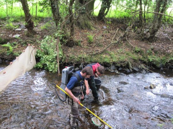
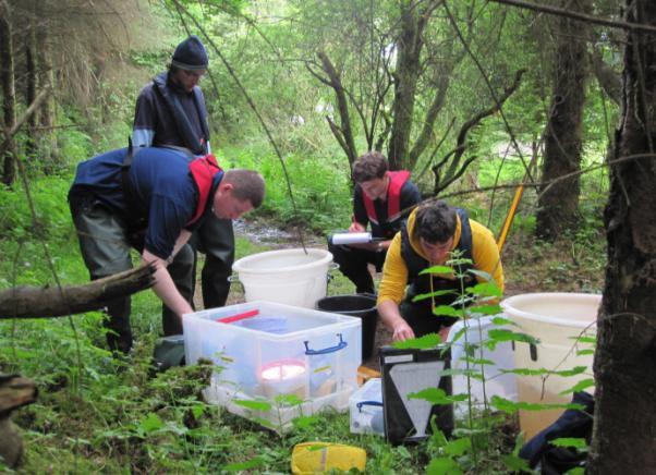
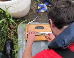
11 FCS2 Ireland was used for the first time within the Loughs Agency jurisdiction in 212 to classify fish in rivers. This methodology is WFD compliant and has replaced professional opinion as the main method of classification. A professional opinion over ride can still be employed if deemed appropriate. Fish classifications will be incorporated into final surface water classifications. Data collection was conducted in the field during July, August and September 212 and involved the use of a quantitative electrofishing methodology and a multi method survey technique. Electrofishing is the preferred method for WFD surveillance monitoring of fish in rivers to obtain a representative sample of fish from each monitoring station. This method is compliant with the European Committee for Standardisation (CEN) standards for assessing fish stocks in wadeable rivers (CEN, 23). Quantitative electrofishing requires the netting off of a section of river using stop nets. Removal sampling is then conducted utilising electrofishing equipment with the numbers, age class and species of each fish being recorded for each pass. After an appropriate depletion has been achieved, which facilitates a density estimation to be made, all fish were returned alive to the river. At a number of larger river sites where quantitative electrofishing was not possible due to width and or depth a multi method sampling approach was adopted which included single pass electrofishing, the deployment of 1m D ring fyke nets overnight and seine netting. Additional habitat variables were recorded and the exact sampling locations were recorded using a Trimble Geo XT hand held GPS unit. Professional judgement over ride can be utilised where classifications are deemed to be inaccurate due to the presence of barriers to migration downstream of the sampling stations. Consideration of this issue has not been incorporated in to the FCS2 (Ireland) model at this time. Other scenarios for professional judgement over ride include significant deviation from expected classification and high water levels during survey. Page 11
12 NURSERY AREA Grade 1 5-8mm water depth.5 8% gradient Stable cobble/boulder substrate > or = 7% bed cover Providing adequate cover Grade 2 Marginally outside grade 1 on one count only Grade 3 Well outside grade 1 on one or more counts Grade 4 Absent, deep, channelized, silty etc. SPAWNING AREA Grade 1 Flow 3 6mm/sec Water depth 15 7mm 7% substrate 3-8mm diameter Gravel depth: Trout = 5-15mm Salmon = 2-5mm Grades 2-4 Failing as for nursery habitat above HOLDING AREA Grade 1 Depth minimum m ideally > or = 2m Suitable cover Bankside/substrate stability Grades 2-4 Failing as for nursery habitat above Table 1. Habitat classification based on Department of Agriculture for Northern Ireland (Fisheries Division) advisory leaflet on the evaluation of habitat for salmon and trout Page 12

13 Figure 1. WFD Fish surveillance river sites within the Foyle area, Northern Ireland and Ireland. Page 13

14 Fig 2. WFD fish surveillance river sites within the Carlingford area, Northern Ireland. There are no sites within Ireland in the Carlingford area. Page 14

15 3. CLASSIFICATIONS 3.1 F12 Dunnyboe Burn at Dunnyboe Bridge GBNI1NW11172 Burndenett WFD Fish Classification 212 HIGH FISHING Salmon + Salmon 1+ Trout + Trout 1+ Eel Total 1st nd rd TOTAL Table 2. Removal sampling results Fig 3. Site F12 Site F12 was surveyed using a quantitative electrofishing method. This involved stop netting the river at both upstream and downstream limits of the selected site. Between the stop nets removal sampling was conducted. From this data density estimates have been calculated for all species present. Page 15
16 Fish Species and Number Caught, Dunnyboe Burn (F12) Number of Fish Salmon + Salmon 1+ Trout + Trout 1+ Eel Species Fig 4. Total catch 6 5 Density Estimate of Fish Species 53 No. of Fish/1m² Salmon + Salmon1+ Trout + Trout 1+ Total Salmon Total Trout Total Salmonids Eel Fish Species Fig 5. Density/1m² Page 16
17 16 14 Length Weight Relationship of Juvenile Salmon Dunnyboe Burn (N=31) 12 y = 2E-5x R² =.9734 Weight (g) Length (mm) Fig 6. Length weight relationship of all salmon 25 2 Length Weight Relationship of Juvenile Trout Dunnyboe Burn (N=11) y = 1E-5x R² =.9963 Weight (g) Length (mm) Fig 7. Length weight relationship of all trout caught Page 17
18 Number of Fish Length (cm) Fig 8. Length frequency distribution for all juvenile salmon caught (this can be used to assess the presence of different age classes/cohorts) Number of Fish Length (cm) Fig 9. Length frequency distribution for all trout caught. Page 18


19 This site is composed predominantly of grade 2 nursery habitat (9%) with grade 3 spawning habitat (1%) and no holding habitat. Additional biological information is available in the spreadsheets provided. This water body has natural channel form at the surveillance site, although there is some tunnelling by bank side tree cover. The left hand bank is planted with a dense stand of conifers which over shadows the water course. There are further issues with tunnelling on this water body which could be limiting primary productivity. Page 19
20 Page 2
21 Page 21

22 3.2 F1763 Skeoge River at Elagh Road GBNI1NW Burnfoot WFD Fish Classification 212 POOR FISHING Salmon + Salmon 1+ Trout + Trout 1+ Stickleback Total 1st nd TOTAL 3 4 Table 3. Removal sampling results Fig 1. Site F1763 Site F1763 was surveyed using a quantitative electrofishing method. This involved stop netting the river at both upstream and downstream limits of the selected site. Between the stop nets removal sampling was conducted. Due to the low numbers of fish present at this site only two passes were made. From this data density estimates have been calculated for all species present. Page 22
23 4 Fish Species and Number Caught, Skeoge River 212 (F1763) Number of Fish Salmon + Salmon 1+ Trout + Trout 1+ Eel Species Lamprey Minnow Stickleback Stone Loach Fig 11. Total catch 4 Density Estimate of Fish Species, Skeoge River 212 (F1763) No. of Fish/1m² Salmon + Salmon1+ Trout + Trout 1+ Tot Sal Tot Tro Tot Salmonids Fish Species Eel Lamprey Minnow Stickleback Stone Loach Fig 12. Density/1m 2 Page 23
24 8 7 Length Weight relationship of Juvenile Trout Skeoge River 212 (n=3) (F1763) Weight (g) y = 8E-6x R² = Length (mm) Fig 13. Length weight relationship of all juvenile trout caught Frequency Length (cm) Fig. 14. Length frequency distribution for all trout caught. Page 24


25 This site is composed predominantly of grade 3 holding habitat (9%) with grade 4 nursery habitat (5%) and grade 4 spawning habitat (5%). This channel has little diversity in river bed substrate and demonstrates significant signs of being arterially drained in the past. This channel forms part of a cross border catchment with the water body ultimately discharging to Lough Swilly, Co Donegal through a heavily modified artificial impoundment at Inch Levels. It is suspected that developments upstream of this site may be responsible for untreated effluent entering this water body from misconnected waste water systems. Additional biological information is available in the spreadsheets provided. Page 25


26 Potential programmes of measures could include; monitoring of consented and non consented discharges, increased water quality monitoring, community engagement and introduction of substrate suitable for native fish species. Page 26
27 Page 27

28 3.3 F125 River Finn (Foyle) at Clady Bridge GBNI1NW11363 Finn WFD Fish Classification 212 MODERATE METHOD Sal 1+ Tro 1+ Eel Minn Flounder SB Roach Gudgeon Total Seine Net st Fyke nd Fyke TOTAL Table 4. Sampling results Fig 15. Site F125 Site F125 has been classified as a large river site where quantitative electrofishing is not possible. This site was surveyed using a multi method approach. The multi method approach is usually conducted across a range of habitats and combines electrofishing at a suitable riffle habitat, seine netting and fyke netting. Due to the high river flows which dominated the 212 field Page 28
29 season the electrofishing component of the survey was unable to be completed. The results presented here are for the seine netting and fyke netting components of the multi method survey only. The data collected during survey was combined and entered into the FCS2 (Ireland) model as a single pass electrofishing exercise. At present the FCS2 (Ireland) model can only accept electrofishing data. Both the professional opinion and FCS2 (Ireland) model classified this site as moderate. If a single pass electrofishing exercise had been conducted this would also have been run through the model both as an independent data set and as a combined data set with the seine and fyke netting results. This would have provided for three independent classifications which would provide the basis for a professional opinion over ride. 3 Fish Species and Number Caught, Finn F125 (212) Number of Fish Salmon + Salmon 1+ Trout + Trout 1+ Eel Species Minnow Flounder Sticklebac k Roach Gudgeon Fig 16. Total catch Page 29
30 14 12 Length Weight Relationship of Trout River Finn F125 (212) n = 21 1 Weight (g) 8 6 y = 4E-5x R² = Length (mm) Fig 17. Length weight relationship of all Trout 8 7 Length Weight Relationship of Roach, Finn F125 (212) n = 26 6 Weight (g) y = 8E-5x R² = Length (mm) Fig 18. Length weight relationship of all Roach Page 3
31 Length Weight Relationship of Eels, Finn F125 (212) n = 13 y = 3E-7x R² =.8122 Weight (g) Length (mm) Fig 19. Length weight relationship of all Eels Length Weight Relationship of Flounder, Finn F125 (212) N = 12 y = 5E-5x R² = Length (mm) Fig 2. Length weight relationship of all Flounder Page 31
32 Frequency Length (cm) Fig 21. Length frequency distribution for all Trout caught (this can be used to assess the presence of different age classes/cohorts) Frequency Length (cm) Fig22. Length frequency distribution for all Roach. Page 32
33 Frequency Length (cm) Fig 23. Length frequency distribution for all Flounder Frequency Length (cm) Fig 24. Length frequency distribution for all Eels. Page 33


34 The site surveyed was uniformly deep and wide in nature with vegetated banks and flood embankments present throughout. Land use adjacent to the site is agricultural in nature alternating between grazing, silage production and arable crops. A suitable site was chosen downstream at a riffle area for electrofishing. It was not possible to survey this site in 212 due to high water levels. Additional biological information is available in the spreadsheets provided. Page 34

35 Page 35
36 Page 36

37 3.4 F114 Glenmornan River GBNI1NW11175 Foyle (with Deele) WFD Fish Classification 212 GOOD FISHING Trout + Trout 1+ Total 1st nd 7 7 3rd th th 3 3 TOTAL Table 5. Removal sampling results Fig 25. Site F114 Site F114 was surveyed using a quantitative electrofishing method. This involved stop netting the river at both upstream and downstream limits of the selected site. Between the stop nets removal sampling was conducted. From this data density estimates have been calculated for all species present. Page 37
38 45 4 Fish Species and Number Caught, Glenmornan 42 (F114) Number of Fish Salmon + Salmon 1+ Trout + Trout 1+ Eel Species Lamprey Minnow Stickleback Stone Loach Fig 26. Total catch No. of Fish/1m² Density Estimate of Fish Species Salmon + Salmon1+ Trout + Trout 1+ Tot Sal Tot Tro Total Salmonids Lamprey Minnow Stickleback Stone Loach Fish Species Fig 27. Density/1m² Page 38
39 8 7 Length Weight Relationship of Trout Glenmornan River (N=6) 6 5 y = 1E-5x 3.28 R² =.9798 Weight (g) Length (mm) Fig 28. Length weight relationship of all trout caught 25 2 Frequency Length (cm) Fig 29. Length frequency distribution for all trout caught. Page 39


 model classified this site as Good.")
40 This site is composed predominantly of grade 3 nursery habitat (75%) with grade 3 spawning habitat (5%) and grade 3 holding habitat (2%). This site was fished upstream of the monitoring station for operational reasons. The exact location is given in the spreadsheets supplied which provide grid references for upstream and downstream stop net locations. The site is upstream of a natural barrier to migration for migratory salmonids. The site is also upstream of a WWTW. Additional biological information is available in the spreadsheets provided. The right hand bank was heavily trampled by livestock. Himalayan balsam was present on both banks and there was some fly tipping also on the right hand bank. Excellent trout holding water upstream. The FCS 2 (Ireland) model classified this site as Good. The professional opinion over ride has not been used here to reflect the author s opinion that this site is at least good as demonstrated by the good presence of trout. It should be noted that there is a natural barrier downstream of this site which would inhibit upstream salmonid migration which may have justified a High status classification. Page 4


41 Potential programmes of measures could include improved riparian land management in the form of stock proof fencing, native buffer zone creation with limited access grazing. Some improvement of in-channel substrate could be conducted by either loosening compacted gravels or by importing new substrate. Treatment of riparian invasive species is also required. Page 41
42 Page 42

43 3.5 F1626 Jerrettspass R (Jerrettspass) GBNI1NB66447 Newry WFD Fish Classification 212 GOOD FISHING Trout + Trout 1+ Eels SB SL Total 1st nd rd TOTAL Table 6. Removal sampling results Fig 3. Site F1626 Site F1626 was surveyed using a quantitative electrofishing method. This involved stop netting the river at both upstream and downstream limits of the selected site. Between the stop nets removal sampling was conducted. From this data density estimates have been calculated for all species present. Page 43
44 25 2 Fish Species and Number Caught, Newry River (F1626) Number of Fish Salmon + Salmon 1+ Trout + Trout 1+ Eel Species Lamprey Minnow Stickleback Stone Loach Fig 31. Total catch Density Estimate of Fish Species No. of Fish/1m² Salmon + Salmon1+ Trout + Trout 1+ Tot Sal Tot Tro Tot Salmonids Eel Lamprey Minnow Stone Loach Fish Species Fig 32. Density/1m² Page 44
45 3 25 Length Weight Relationship of Trout Newry River (N=28) 2 y = 1E-4x R² =.928 Weight (g) Length (mm) Fig 33. Length weight relationship of all trout caught Frequency Length (cm) Fig. 34. Length frequency distribution for all trout caught. Page 45
. This site is located at a Rivers Agency gauging station.")


46 This site is composed of grade 3 nursery habitat (7%), grade 3 spawning habitat (1%) and grade 3 holding habitat (2%). This site is located at a Rivers Agency gauging station. There is tunnelling by overhanging trees downstream of the site. Green sponges and aquatic vegetation are growing within the channel. Potential programmes of measures could include improved riparian land management in the form of stock proof fencing, native buffer zone creation with limited access grazing. Some improvement of in-channel habitat could be Page 46


47 made by importing new nursery and spawning substrate and by creating some holding water developing a functional habitat unit. Some bank side maintenance is required. Page 47
48 Page 48

49 3.6 F1124 Newry River at Damolly Row GBNI1NB66446 Newry WFD Fish Classification 212 MODERATE FISHING Tro + Tro 1+ Eel Lamp SB Minn SL Total 1st TOTAL Table 7. Removal sampling results Fig 35. Site F1124 Site F1124 was surveyed using a single pass electrofishing method. The FCS2 (Ireland) model can accept data from a single pass electrofishing survey within a defined area. This site was surveyed in higher than desired water conditions. Due to the prevailing water conditions the decision was taken to survey in sub optimal conditions. Minimum density estimates were calculated for all species based on the single pass electrofishing results and the area surveyed. Page 49
50 Fish Species and Number Caught, Newry River (F1124) Number of Fish Salmon + Salmon 1+ Trout + Trout 1+ Eel Lamprey Minnow Stickleback Stone Loach Species Fig 36. Total catch 4 Density Estimate of Fish Species No. of Fish/1m² Salmon + Salmon1+ Trout + Trout 1+ Lamprey Minnow Stone Loach Fish Species Fig 37. Density estimate/1m 2 Page 5
51 14 12 Length Weight Relationship of Trout Newry River (N=6) y = 2E-5x R² = Weight (g) Length (mm) Fig 38. Length weight relationship of all Trout caught 3 25 Length Weight Relationship of Eels Newry River (N= 5) y = 5E-7x R² = Weight(g) Length (mm) Fig 39. Length weight relationship of all Eels caught Page 51
52 4 Length Weight Relationship of Lamprey Newry River (N= 8) y = 2E-7x R² = Weight(g) Length (mm) Fig 4. Length weight relationship of all lamprey caught Frequency Length (cm) Fig 41. Length frequency distribution of all trout caught Page 52

.")


53 This site is composed of grade 4 nursery habitat (45%) and grade 3 holding habitat (55%). This site was surveyed in higher than desired water conditions which made it difficult to fully appraise the in-channel habitat. Page 53


54 This site demonstrates evidence of being arterially drained. Potential programmes of measures could include importing new spawning and nursery substrate to compensate for substrate lost at the time of drainage. It should be noted that at the downstream end of the site underneath the clear span road bridge there is good lamprey ammocoete habitat which should be left undisturbed. Page 54
55 Page 55

56 3.7 F176 Coneyglen Burn at Coneyglen Br GBNI1NW11285 Owenkillew WFD Fish Classification 212 Moderate FISHING Sal + Sal 1+ Tro + Eel Total 1st nd rd TOTAL Table 8. Removal sampling results Fig 42. Site F176 Site F176 was surveyed using a quantitative electrofishing method. This involved stop netting the river at both upstream and downstream limits of the selected site. Between the stop nets removal sampling was conducted. From this data density estimates have been calculated for all species present. Page 56
57 Fish Species and Number Caught, Owenkillew (F176) Number of Fish Salmon + Salmon 1+ Trout + Trout 1+ Eel Lamprey Minnow Stickleback Stone Loach Species Fig 43. Total catch Density Estimate of Fish Species Owenkillew River No. of Fish/1m² Salmon + Salmon1+ Trout + Trout 1+ Total Sal Total Tro Total Salmonids Eel Lamprey Minnow Stone Loach Stickleback Fish Species Fig 44. Density estimate/1m 2 Page 57
58 35 3 Length Weight Relationship of Salmon Owenkillew River (N=53) 25 Weight (g) 2 15 y = 9E-6x 3.64 R² = Length (mm) Fig 45. Length weight relationship of all juvenile Salmon caught Frequency Length (cm) Fig 46. Length frequency distribution for all salmon caught Page 58
 and grade 3 holding habitat (15%).")
 model classified this site as Poor, the professional")

59 This site is composed of grade 2 nursery habitat (7%), grade 3 spawning habitat (15%) and grade 3 holding habitat (15%). This site is located downstream of a ford connecting two fields. The FCS 2 (Ireland) model classified this site as Poor, the professional opinion over ride has been used here to reflect the author s opinion that this site is at least moderate as demonstrated by the good presence of salmon and the presence of trout and eels. Page 59


60 Potential programmes of measures could include installing a clear span bridge to replace the existing ford or the creation of alternative access. Page 6
61 Page 61

62 3.8 F177 Owenkillew R at Monanameal Br GBNI1NW11286 Owenkillew WFD Fish Classification 212 GOOD FISHING Sal + Sal 1+ Tro 1+ Eel Total 1st TOTAL Table 9. Removal sampling results Fig 47. Site F177 Site F177 was surveyed using a single pass electrofishing method. The FCS2 (Ireland) model can accept data from a single pass electrofishing survey within a defined area. This site was surveyed in higher than desired water conditions. Due to the prevailing water conditions the decision was taken to survey in sub optimal conditions. Minimum density estimates were calculated for all species based on the single pass electrofishing results and the area surveyed. Page 62
63 Fish Species and Number Caught, Owenkillew (F177) Salmon + Salmon 1+ Trout + Trout 1+ Eel Lamprey Minnow Stickleback Stone Loach Number of Fish Species Fig 48. Total catch No. of Fish/1m² Salmon + Density Estimate of Fish Species Salmon1+ Trout + Trout 1+ Total Sal Total Tro Fish Species Total Salmonids Lamprey Minnow Stone Loach Fig 49. Density estimate/1m 2 Page 63
64 3 25 Length Weight Relationship of Salmon Owenkillew (N=1) 2 Weight (g) 15 y = 2E-5x R² = Length (mm) Fig 5. Length weight relationship of all Salmon caught Frequency Length (cm) Fig 51. Length frequency distribution of all Salmon caught Page 64
.")


65 This site is composed of grade 1 nursery habitat (85%), grade 3 spawning habitat (1%) and grade 3 holding habitat (5%). This site was surveyed in higher than desired water conditions which made it difficult to fully appraise the in-channel habitat. The FCS 2 (Ireland) model classified this site as moderate. The professional opinion over ride has been used here to reflect the author s opinion that this site is at least good as demonstrated by the good presence of salmon and the presence of trout and eels as recorded during less than optimal conditions. Page 65


66 Potential programmes of measures include the development of catchment initiatives to ensure water quality and habitat quality are maintained or improved. Page 66
67 Page 67

68 3.9 F186 Strule R at Moyle Br GBNI1NW1122 Strule WFD Fish Classification 212 GOOD METHOD Sal 1+ Sal 1+ Tro 1+ Eel Minn SL SB Gudgeon Total EF Single Pass Seine Net st Fyke nd Fyke TOTAL Table 1. Sampling results Fig 52. Site F186 Site F186 has been classified as a large river site where quantitative electrofishing is not possible. This site was surveyed using a multi method approach. The multi method approach is usually conducted across a range of habitats and combines electrofishing at a suitable riffle habitat, seine netting Page 68
69 and fyke netting. Due to the high river flows which dominated the 212 field season the electrofishing component of the survey was conducted in sub optimal conditions. The data collected during this survey was pooled in three separate ways and entered into the FCS2 (Ireland) model as single pass electrofishing exercises. The three groupings were single pass electrofishing data only, netting data only and all data combined. At present the FCS2 (Ireland) model can only accept electrofishing data. Both the professional opinion and FCS2 (Ireland) model utilising all three pooled data sets classified this site as Good. This provided three independent classifications. 8 Fish Species and Number Caught, Strule (Moyles Bridge) Number of Fish Salmon + Salmon 1+ Trout + Trout 1+ Eel Lamprey Minnow Stickleback Stone Loach Gudgeon Species Fig 53. Total catch Page 69
70 3 25 Length Weight Relationship of Salmon, (Moyles Bridge) Strule (N=33) Weight (g) 2 15 y = 3E-5x R² = Length (mm) Fig 54. Length weight relationship of all juvenile Salmon Length Weight Relationship of Trout, (Moyles Bridge) Strule (N=7) y = 2E-5x R² =.9729 Weight (g) Length (mm) Fig 55. Length weight relationship of all Trout Page 7
71 Frequency Length (cm) Fig 56. Length frequency distribution of all juvenile Salmon Frequency Length (cm) Fig 57. Length frequency distribution of all Trout Page 71


72 The site surveyed was composed of a deep riffle area flowing into a glide which in turn ran into a deeper pool area. The area surveyed included grade 3 nursery habitat, grade 3 spawning habitat and grade 1 holding habitat. This site was surveyed in higher than desired water conditions which made it difficult to fully appraise the in-channel habitat. Additional biological information is available in the spreadsheets provided. Page 72


73 Potential programmes of measures include the development of catchment initiatives to ensure water quality and habitat quality are maintained or improved. Page 73
74 Page 74

75 3.1 F189 Cappagh Burn at Tattynure Br GBNI1NW11221 Strule WFD Fish Classification 212 GOOD FISHING Sal + Sal 1+ Tro + Tro 1+ Lam SL Total 1st nd rd TOTAL Table 11. Removal sampling results Fig 58. Site F189 Site F189 was surveyed using a quantitative electrofishing method. This involved stop netting the river at both upstream and downstream limits of the selected site. Between the stop nets removal sampling was conducted. From this data density estimates have been calculated for all species present. Page 75
76 3 25 Fish Species and Number Caught, Cappagh Burn (F189) Number of Fish Salmon + Salmon 1+ Trout + Trout 1+ Eel Species Lamprey Minnow Stickleback Stone Loach Fig 59. Total catch 6 5 Density Estimate of Fish Species in Cappagh Burn 53 No. of Fish/1m² Salmon + Salmon1+ Trout + Trout 1+ Total Sal Total Tro Fish Species Total Salmonids Lamprey Minnow Stone Loach Fig 6. Density estimate/1m 2 Page 76
77 3 25 Length Weight Relationship of Salmon Cappagh Burn (N=16) 2 Weight (g) 15 y = 2E-5x R² = Length (mm) Fig 61. Length weight relationship of all juvenile Salmon caught 7 6 Length Weight Relationship of Trout Cappagh Burn (N=36) 5 y = 2E-5x R² =.9868 Weight (g) Length (mm) Fig 62. Length weight relationship of all trout caught Page 77
78 Frequency Length (cm) Fig 63. Length frequency distribution for all juvenile salmon caught Frequency Length (cm) Fig 64. Length frequency distribution for all trout caught Page 78
.")


79 This site is composed of grade 3 nursery habitat (75%), grade 3 spawning habitat (15%) and grade 4 holding habitat (1%). The site surveyed is slightly downstream of the site surveyed in 29. There is trampling of the bank in places by livestock and no fencing. This water course experiences high energy floods which has caused erosion in places. Programmes of measures could include stock proof fencing with gated access, tree coppicing and catchment scale initiatives to improve water quality and to ameliorate the impacts of flooding. Page 79

80 Page 8
81 Page 81

82 3.11 F1644 Kilbroney River at Newtown Br GBNI1NB66441 Kilkeel and Mourne WFD Fish Classification 212 POOR FISHING Tro + Tro 1+ Total 1st nd rd TOTAL Table 12. Removal sampling results Fig 65. Site F1644 Site F1644 was surveyed using a quantitative electrofishing method. This involved stop netting the river at both upstream and downstream limits of the selected site. Between the stop nets removal sampling was conducted. From this data density estimates have been calculated for all species present. Page 82
83 16 14 Fish Species and Number Caught, Kilbroney River (F1644) Number of Fish Salmon + Salmon 1+ Trout + Trout 1+ Eel Species Lamprey Minnow Stickleback Stone Loach Fig 66. Total catch Density Estimate of Fish Species No. of Fish/1m² Salmon + Salmon1+ Trout + Trout 1+ Tot Sal Tot Tro Tot Salmonids Eel Lamprey Minnow Stone Loach Fish Species Fig 67. Density estimate/1m 2 Page 83
84 Length Weight Relationship for Trout in Kilbroney River 35 Weight (g) y = 7E-6x R² = Length (mm) Fig 68. Length weight relationship of all Trout caught Frequency Length (cm) Fig 7. Length frequency distribution for all Trout caught Page 84
. The site is located above the bridge and weir.")


85 This site is composed of grade 3 nursery habitat (55%) and grade 3 holding habitat (45%). The site is located above the bridge and weir. Access to the bridge site is not possible. Rivers Agency bank protection works have impacted channel diversity. Fly tipping and tunnelling in places. Possible programmes of measures could include reconnection of river with floodplain on right hand bank downstream of bridge. Tree coppicing. Community involvement and catchment scale initiatives to improve water quality. Page 85
86 Page 86
87 Page 87
88 4. OVERVIEW OF WFD FISH SURVEILLANCE RESULTS The results for WFD river fish monitoring within the Loughs Agency areas from are outlined in the table below. In 212 a total of eleven WFD river fish surveillance monitoring stations were monitored, classifications are outlined in the figure below. FCS2 (Ireland) was the primary classification tool from 212, prior to this classifications were based on professional opinion. Site Year Catchment Classification Code Surveyed F Strule Good Good 1 st F Strule Mod Good F Owenkillew Good Mod F12 29 Burndennet Good High F Glenmornan Mod Good F Newry Mod Good F Killbroney Mod Poor F Owenkillew Good Good F Skeoge Poor Poor F Burndennet Good F Derg Good F Glenelly Good F Camowen Good F Roe Good F Camowen Good F Derg Good F Drumragh Good F Fairywater Good F Faughan Good F Owenkillew Good Page 88
89 F Roe Good F Finn Mod F Newry Mod Table 13. WFD fish surveillance stations surveyed by the Loughs Agency Page 89

90 Fig 71. Loughs Agency WFD fish surveillance water body classifications 212 Foyle area Page 9
91 Fig 72. Loughs Agency WFD fish surveillance water body classifications 212 Carlingford area Page 91
92 5. SEMI QUANTITATIVE/SALMON MANAGEMENT PLAN CLASSIFICATIONS During 212 the NI WFD Fish Group continued to develop and refine the set of rules for deriving indicative fish classifications for waterbodies in which annual semi quantitative/salmon management plan electrofishing surveys are conducted. Within the Foyle and Carlingford areas approximately 5 sites are semi quantitatively surveyed annually. The ability to derive indicative classifications would greatly facilitate the ability to highlight pressures within specific waterbodies and to assist with the development of programmes of measures. The refined rules as of January 213 are listed below. 1. Only use if there are a minimum of three sites per water body - suggest a minimum of the three largest rivers for which data is available important to record the stations used. 2. Classify according to the dominant salmonid species within the water body where adequate historical data is available. 3. Classify if 66% of sites agree 4. Classify as Good or better or as Poor or worse 5. Use the most recent years data The maps below provide an overview of results for the application of this method within the Foyle and Carlingford areas in 212. GIS shape files containing the raw data behind these maps including site id s has been provided to NIEA. It should be noted that fewer than average sites were surveyed in 212 using the semi quantitative/salmon management plan method due to prolonged high water during the 212 survey season. A significant number of water bodies were classified. For waterbodies that were classified using both methods one site in the Foyle area and one site in the Carlingford area were in disagreement. In all cases the FCS2 (Ireland) tool classified the waterbody one grade higher. This is deemed to be acceptable under a precautionary approach. Page 92
93 Fig 73. Foyle area Semi quantitative/salmon management plan derived indicative water body classifications 212 Page 93
94 Fig 74. Carlingford area Semi quantitative/salmon management plan derived indicative water body classifications 212 Page 94
95 Fig 75. Foyle area combined WFD surveillance and semi quantitative/salmon management plan classifications 212 Page 95

96 Fig 76. Carlingford area combined WFD surveillance and semi quantitative/salmon management plan classifications 212 Page 96
97 6. CONCLUSION From 212 classification has been predominantly based on the FCS2 (Ireland) model. This has replaced the professional opinion classification method as the dominant classification method. A professional opinion over ride exists to correct classifications based on a paucity of information including the presence of barriers downstream to a monitored site. The professional opinion override was not utilised in 212. Site Id Site Name Professional Opinion Classification FCS2 Classification F12 DUNNYBOE BURN AT Good High DUNNYBOE BR F1763 SKEOGE RIVER AT ELAGH Poor Poor ROAD F125 FINN (FOYLE) R AT CLADY Moderate Moderate BR F114 GLENMORNAN R AT Good Good CATHERINES BR F1626 JERRETTSPASS R AT Moderate Good JERRETTSPASS F1124 NEWRY R AT DAMOLLY Moderate Moderate ROW F176 CONEYGLEN BURN AT Good Moderate CONEYGLEN BR F177 OWENKILLEW R AT Good Good MONANAMEAL BR F186 STRULE R AT MOYLE BR Good Good F189 CAPPAGH BURN AT Good Good TATTYNURE BR F1644 KILBRONEY R AT Moderate Poor NEWTOWN BR Table 14. WFD surveillance site classifications 212. Comparison with professional opinion, FCS2 (Ireland) and professional opinion over ride. The FCS2 (Ireland) tool has passed the intercalibration process and has now been fully adopted for use across the island of Ireland. Further refinements may be made to the model in the future to incorporate issues such as full consideration of barriers downstream and acceptance of different types of Page 97
98 survey data. Adoption of the FCS2 (Ireland) model marks an end to a very positive beginning for WFD compliant fish monitoring in the rivers of Northern Ireland. A degree of flexibility will need to be maintained in collecting and analysing fisheries data which can be utilised for WFD classification purposes and to ensure future development of the model Professional Opinion FCS Percentage High Good Moderate Poor Bad Classification Fig 77. Percentage of water bodies in each class determined using professional opinion and FCS2 (Ireland) classification methods for the Foyle and Carlingford areas 212. REFERENCES CEN (23) Water Quality Sampling of Fish with Electricity. European Standard. Ref. No. EN1411:2. Council of the European Communities (2) Establishing a framework for community action in the field of water policy. Directive of the European Parliament and of the Council establishing a framework (2)/6/EC). Official Journal of the European Communities, 43, UK Technical Advisory Group on the Water Framework Directive (212) Proposed recommendations on biological standards, Consultation Page 98
Loughs Agency Water Framework Directive Fish in Rivers Classification Report 2014 Water Framework Directive Fish Population Assessment
 LOUGHS AGENCY OF THE FOYLE CARLINGFORD AND IRISH LIGHTS COMMISSION Loughs Agency Water Framework Directive Fish in Rivers Classification Report 214 Water Framework Directive Fish Population Assessment
Stillwater Status Report: Lough Muck, County Donegal
 LOUGHS AGENCY OF THE FOYLE CARLINGFORD AND IRISH LIGHTS COMMISSION Stillwater Status Report: Lough Muck, County Donegal Stillwater Fish Stock Survey Loughs Agency of the Foyle Carlingford and Irish Lights
Stillwater Status Report: Lough Muck, County Tyrone
 LOUGHS AGENCY OF THE FOYLE CARLINGFORD AND IRISH LIGHTS COMMISSION Stillwater Status Report: Lough Muck, County Tyrone Stillwater Fish Stock Survey Loughs Agency of the Foyle Carlingford and Irish Lights
Stillwater Status Report: Lough Mourne, County Donegal
 LOUGHS AGENCY OF THE FOYLE CARLINGFORD AND IRISH LIGHTS COMMISSION Stillwater Status Report: Lough Mourne, County Donegal Stillwater Fish Stock Survey Loughs Agency of the Foyle Carlingford and Irish Lights
Loughs Agency Freshwater Fisheries Monitoring Programme
 Loughs Agency Freshwater Fisheries Monitoring Programme Fisheries Coordination Centre/RAFTS Annual Biologists Meeting 29 th 30 th January 2014 Marine Scotland Freshwater Laboratory, Pitlochry Art Niven,
Foyle Area and Tributaries Catchment Status Report 2015 Conservation and assessment of fish populations and aquatic habitats
 LOUGHS AGENCY OF THE FOYLE CARLINGFORD AND IRISH LIGHTS COMMISSION Foyle Area and Tributaries Catchment Status Report 2015 Conservation and assessment of fish populations and aquatic habitats Art Niven,
Foyle Area and Tributaries Catchment Status Report 2014 Conservation and assessment of fish populations and aquatic habitats
 LOUGHS AGENCY OF THE FOYLE CARLINGFORD AND IRISH LIGHTS COMMISSION Foyle Area and Tributaries Catchment Status Report 2014 Conservation and assessment of fish populations and aquatic habitats Art Niven,
Fairywater River and Tributaries Catchment Status Report 2011 Conservation, protection and assessment of fish populations and aquatic habitats
 This document and its contents are copyright of the Loughs Agency 212 LOUGHS AGENCY OF THE FOYLE CARLINGFORD AND IRISH LIGHTS COMMISSION Fairywater River and Tributaries Catchment Status Report 211 Conservation,
Foyle Area and Tributaries Catchment Status Report 2016 Conservation and assessment of fish populations and aquatic habitats
 LOUGHS AGENCY OF THE FOYLE CARLINGFORD AND IRISH LIGHTS COMMISSION Foyle Area and Tributaries Catchment Status Report 2016 Conservation and assessment of fish populations and aquatic habitats Art Niven
River Finn and Tributaries Catchment Status Report 2011 Conservation, protection and assessment of fish populations and aquatic habitats
 This document and its contents are copyright of the Loughs Agency 2012 LOUGHS AGENCY OF THE FOYLE CARLINGFORD AND IRISH LIGHTS COMMISSION River Finn and Tributaries Catchment Status Report 2011 Conservation,
Glenelly River and Tributaries catchment Status Report 2011 Conservation, protection and assessment of fish populations and aquatic habitats
 This document and its contents are copyright of the Loughs Agency 2012 LOUGHS AGENCY OF THE FOYLE CARLINGFORD AND IRISH LIGHTS COMMISSION Glenelly River and Tributaries catchment Status Report 2011 Conservation,
A review of Rotary Screw Trap operations on the River Faughan
 LOUGHS AGENCY OF THE FOYLE CARLINGFORD AND IRISH LIGHTS COMMISSION A review of Rotary Screw Trap operations on the River Faughan 2003-2016 Monitoring and Conservation Loughs Agency of the Foyle Carlingford
River Derg and Tributaries Catchment Status Report 2011 Conservation, protection and assessment of fish populations and aquatic habitats
 This document and its contents are copyright of the Loughs Agency 212 LOUGHS AGENCY OF THE FOYLE CARLINGFORD AND IRISH LIGHTS COMMISSION River Derg and Tributaries Catchment Status Report 211 Conservation,
Stillwater Status Report: Enagh Lough East
 LOUGHS AGENCY OF THE FOYLE CARLINGFORD AND IRISH LIGHTS COMMISSION Stillwater Status Report: Enagh Lough East Stillwater Fish Stock Survey Loughs Agency of the Foyle Carlingford and Irish Lights Commission
COPYRIGHT 2012 LOUGHS AGENCY OF THE FOYLE CARLINGFORD AND IRISH LIGHTS COMMISSION LOUGHS AGENCY OF THE FOYLE CARLINGFORD AND IRISH LIGHTS COMMISSION
 LOUGHS AGENCY OF THE FOYLE CARLINGFORD AND IRISH LIGHTS COMMISSION Burndennet, Glenmornan River and Tributaries Catchment Status Report 2011 Conservation, protection and assessment of fish populations
Carlingford Area and Tributaries Catchment Status Report 2014 Conservation and assessment of fish populations and aquatic habitats
 LOUGHS AGENCY OF THE FOYLE CARLINGFORD AND IRISH LIGHTS COMMISSION Carlingford Area and Tributaries Catchment Status Report 2014 Conservation and assessment of fish populations and aquatic habitats Art
European Smelt (Osmerus eperlanus L.) Baseline Surveys on the River Foyle, River Finn, River Deele & Burndennet River
 Baseline Surveys on the River Foyle, River Finn, River Deele & Burndennet River") 2010 European Smelt (Osmerus eperlanus L.) Baseline Surveys on the River Foyle, River Finn, River Deele & Burndennet River Loughs Agency of the Foyle Carlingford and Irish Lights Commission Report Ref:
2010 European Smelt (Osmerus eperlanus L.) Baseline Surveys on the River Foyle, River Finn, River Deele & Burndennet River Loughs Agency of the Foyle Carlingford and Irish Lights Commission Report Ref:
Culdaff River, Inishowen and Tributaries Catchment Status Report 2011 Conservation, protection and assessment of fish populations and aquatic habitats
 This document and its contents are copyright of the Loughs Agency 2012 LOUGHS AGENCY OF THE FOYLE CARLINGFORD AND IRISH LIGHTS COMMISSION Culdaff River, Inishowen and Tributaries Catchment Status Report
[Type a quote from the document or the summary of an interesting point. You can
 [Type a quote from the document or the summary of an interesting point. You can position the text box anywhere in the document Use the Text Box Tools tabto LOUGHS AGENCY OF THE FOYLE CARLINGFORD AND IRISH
River Roe and Tributaries Catchment Status Report 2011 Conservation, protection and assessment of fish populations and aquatic habitats
 This document and its contents are copyright of the Loughs Agency 2012 LOUGHS AGENCY OF THE FOYLE CARLINGFORD AND IRISH LIGHTS COMMISSION River Roe and Tributaries Catchment Status Report 2011 Conservation,
Water Framework Directive Fish Stock Survey of Rivers in the South Western River Basin District, 2013
 Water Framework Directive Fish Stock Survey of Rivers in the South Western River Basin District, 213 Fiona L. Kelly, Ronan Matson, Lynda Connor, Rory Feeney, Emma Morrissey, John Coyne and Kieran Rocks
Know Your River Conwy Salmon & Sea Trout Catchment Summary
 Know Your River Conwy Salmon & Sea Trout Catchment Summary Introduction This report describes the status of the salmon and sea trout populations in the Conwy catchment. Bringing together data from rod
Stillwater Status Report: Camlough, Co. Armagh
 LOUGHS AGENCY OF THE FOYLE CARLINGFORD AND IRISH LIGHTS COMMISSION Stillwater Status Report: Camlough, Co. Armagh Stillwater Fish Stock Survey Loughs Agency of the Foyle Carlingford and Irish Lights Commission
Fish population survey report
 Fish population survey report Upper River Avon Catchment This report provides a summary of results from recent fish population surveys on the Tetbury Avon, Sherston Avon and River Marden The surveys were
Big Spring Creek Habitat Enhancement and Fishery Management Plans
 Big Spring Creek Habitat Enhancement and Fishery Management Plans November 5, 2012 Big Spring Events and Activities Center Newville, PA Charlie McGarrell Regional Habitat Biologist Pennsylvania Fish and
Loughs Agency Gníomhaireacht na Lochanna Factrie fur Loughs
 CONSULTATION DOCUMENT PROPOSED AMENDMENTS OF THE FOYLE AREA (CONTROL OF FISHING) REGULATIONS 1999 Foyle Area (Control of Fishing) (Amendment) Regulations 2008 INTRODUCTION This Consultation Document sets
Water Framework Directive Fish Stock Survey of Glencar Lough, August 2013
 1 Water Framework Directive Fish Stock Survey of Glencar Lough, August 2013 Fiona L. Kelly, Lynda Connor, Emma Morrissey, John Coyne, Ronan Matson, Rory Feeney and Kieran Rocks Inland Fisheries Ireland,
Sea trout (Salmo trutta L.) Status Report: Foyle & Carlingford Areas
 Status Report: Foyle & Carlingford Areas") LOUGHS AGENCY OF THE FOYLE CARLINGFORD AND IRISH LIGHTS COMMISSION Sea trout (Salmo trutta L.) Status Report: Foyle & Carlingford Areas Monitoring, Conservation & Protection Loughs Agency of the Foyle
LOUGHS AGENCY OF THE FOYLE CARLINGFORD AND IRISH LIGHTS COMMISSION Sea trout (Salmo trutta L.) Status Report: Foyle & Carlingford Areas Monitoring, Conservation & Protection Loughs Agency of the Foyle
Fish population survey report
 Fish population survey report River Teme 2016 This report provides a summary of results from recent coarse fish population surveys on the River Teme between Tenbury Wells and Powick. The surveys were carried
Know Your River Conwy Salmon & Sea Trout Catchment Summary
 Know Your River Conwy Salmon & Sea Trout Catchment Summary Introduction This report describes the status of the salmon and sea trout populations in the Conwy catchment. Bringing together data from rod
Fish population survey report
 Fish population survey report River Lugg This report provides a summary of results from recent fish population surveys on the River Lugg between Leominster and Hereford. The surveys were carried out to
ELECTRO-FISHING REPORT 2016 UPPER TWEED
 ELECTRO-FISHING REPORT 2016 UPPER TWEED The electro-fishing programme carried out each summer by The Tweed Foundation is part of our management plan, which details the information that is required to manage
Know Your River - River Ogmore Salmon and Sea Trout Catchment Summary
 Know Your River - River Ogmore Salmon and Sea Trout Catchment Summary Introduction This report describes the status of the salmon and sea trout populations in the Ogmore catchments. Bringing together data
Guidance Note. Hydropower Guidance Note: HGN 8 Fish Passage. When do you need to install a fish pass?
 Guidance Note Hydropower Guidance Note: This guidance note is not intended as a statement of law. It should be read in combination with, and in the context of, the relevant enactments and EU obligations.
Water Framework Directive Fish Stock Survey of Lickeen Lough, September 2013
 1 Water Framework Directive Fish Stock Survey of Lickeen Lough, September 2013 Fiona L. Kelly, Lynda Connor, Emma Morrissey, John Coyne, Ronan Matson, Rory Feeney and Kieran Rocks Inland Fisheries Ireland,
Water Framework Directive Fish Stock Survey of Transitional Waters in the South Western River Basin District Lough Gill
 Water Framework Directive Fish Stock Survey of Transitional Waters in the South Western River Basin District Lough Gill Fiona L. Kelly, Ronan Matson, John Coyne, Rory Feeney, Emma Morrissey, and Kieran
Cornwell brook Cornwell Manor
 Cornwell brook Cornwell Manor An Advisory Visit by the Wild Trout Trust February 2014 1 1. Introduction This report is the output of a Wild Trout Trust visit to a tributary of the Cornwell Brook at Cornwell
Water Framework Directive Fish Stock Survey of Lough Meelagh, August 2014
 1 Water Framework Directive Fish Stock Survey of Lough Meelagh, August 2014 Fiona L. Kelly, Lynda Connor, Emma Morrissey, John Coyne, Rory Feeney, Ronan Matson and Kieran Rocks Inland Fisheries Ireland,
Know Your River - Clwyd Salmon & Sea Trout Catchment Summary
 Know Your River - Clwyd Salmon & Sea Trout Catchment Summary Introduction This report describes the status of the salmon and sea trout populations in the Clwyd catchment. Bringing together data from rod
Water Framework Directive Fish Stock Survey of Glenbeg Lough, September 2014
 1 Water Framework Directive Fish Stock Survey of Glenbeg Lough, September 2014 Fiona L. Kelly, Lynda Connor, Emma Morrissey, John Coyne, Rory Feeney, Ronan Matson and Kieran Rocks Inland Fisheries Ireland,
Council CNL(16)37. Annual Progress Report on Actions Taken Under the Implementation Plan for the Calendar Year EU - UK (Northern Ireland)
37. Annual Progress Report on Actions Taken Under the Implementation Plan for the Calendar Year EU - UK (Northern Ireland)") Agenda item 6.1 For information Council CNL(16)37 Annual Progress Report on Actions Taken Under the Implementation Plan for the Calendar Year 2015 EU - UK (Northern Ireland) CNL(16)37 Annual Progress
Agenda item 6.1 For information Council CNL(16)37 Annual Progress Report on Actions Taken Under the Implementation Plan for the Calendar Year 2015 EU - UK (Northern Ireland) CNL(16)37 Annual Progress
Know Your River - Ogwen Salmon & Sea Trout Catchment Summary
 Know Your River - Ogwen Salmon & Sea Trout Catchment Summary Introduction This report describes the status of the salmon and sea trout populations in the Ogwen catchment. Bringing together data from rod
Water Framework Directive Fish Stock Survey of Lough Rea, July 2013
 1 Water Framework Directive Fish Stock Survey of Lough Rea, July 2013 Fiona L. Kelly, Lynda Connor, Emma Morrissey, John Coyne, Ronan Matson, Rory Feeney and Kieran Rocks Inland Fisheries Ireland, 3044
Know Your River River Afan Salmon and Sea Trout Catchment Summary
 Know Your River River Afan Salmon and Sea Trout Catchment Summary Introduction This report describes the status of the salmon and sea trout populations in the Afan catchments. Bringing together data from
We would also like to thank Dr. Martin O Grady (CFB) and No. 3 Operational Wing, Irish Air Corps (Aer Chór na héireann) for the aerial photographs.
 and No. 3 Operational Wing, Irish Air Corps (Aer Chór na héireann) for the aerial photographs.") ACKNOWLEDGEMENTS The authors wish to gratefully acknowledge the help and co-operation of the acting CEO Dr. Milton Matthews and staff of the Northern Regional Fisheries Board. The authors would also like
ACKNOWLEDGEMENTS The authors wish to gratefully acknowledge the help and co-operation of the acting CEO Dr. Milton Matthews and staff of the Northern Regional Fisheries Board. The authors would also like
Water Framework Directive Fish Stock Survey of Upper Lake, September 2011
 1 Water Framework Directive Fish Stock Survey of Upper Lake, September 2011 Fiona L. Kelly, Lynda Connor, Emma Morrissey, Ciara Wogerbauer, Ronan Matson, Rory Feeney and Kieran Rocks Inland Fisheries Ireland,
Know Your River - Clwyd Salmon & Sea Trout Catchment Summary
 Know Your River - Clwyd Salmon & Sea Trout Catchment Summary Introduction This report describes the status of the salmon and sea trout populations in the Clwyd catchment. Bringing together data from rod
Minutes of Meeting of the Salmon, Inland Fisheries and Environmental Focus Group. Wednesday 26 th March Silverbirch Hotel, Omagh
 Minutes of Meeting of the Salmon, Inland Fisheries and Environmental Focus Group Wednesday 26 th March 2014 Silverbirch Hotel, Omagh Present Forum Members Jim Haughey Tony French Eamon Mullan Michael Stinson
Loughs Agency. Foyle, Carlingford and Irish Lights Commission. Pre-Fishery Stock Assessment Lough Foyle Native Oyster Fishery.
 Loughs Agency Foyle, Carlingford and Irish Lights Commission Pre-Fishery Stock Assessment Lough Foyle Native Oyster Fishery Summary Report Autumn 216 1 Aquaculture & Shellfisheries Report Reference LA/Y/216
Marine Tourism and Angling Development Facilities
 Marine Tourism and Angling Development Facilities Contents Introduction... 2 List of Partners... 2 Gribben Quay... 3 Backwater... 4 Mellon Beat... 5 Malin Head... 6 Benone Beach Activity Centre... 7 Greencastle
Data Report : Russian River Basin Steelhead and Coho Salmon Monitoring Program Pilot Study
 Data Report 1999-1: Russian River Basin Steelhead and Coho Salmon Monitoring Program Pilot Study Sonoma County Water Agency 215 West College Avenue Santa Rosa, California 951 Prepared by David Cook Senior
Know Your River River Neath Salmon and Sea Trout Catchment Summary
 Know Your River River Neath Salmon and Sea Trout Catchment Summary Introduction This report describes the status of the salmon and sea trout populations in the Neath catchments. Bringing together data
Abundance of Steelhead and Coho Salmon in the Lagunitas Creek Drainage, Marin County, California
 scanned for KRIS Abundance of Steelhead and Coho Salmon in the Lagunitas Creek Drainage, Marin County, California Prepared for: Marin Municipal Water District 220 Nellen Drive Corte Madera, California
Know Your River River Loughor Salmon and Sea Trout Catchment Summary
 Know Your River River Loughor Salmon and Sea Trout Catchment Summary Introduction This report describes the status of the salmon and sea trout populations in the Loughor catchments. Bringing together data
Water Framework Directive Fish Stock Survey of Maumwee Lough, August 2013
 1 Water Framework Directive Fish Stock Survey of Maumwee Lough, August 2013 Fiona L. Kelly, Lynda Connor, Emma Morrissey, John Coyne, Ronan Matson, Rory Feeney and Kieran Rocks Inland Fisheries Ireland,
Water Framework Directive Fish Stock Survey of Upper Lake, Killarney, September 2014
 1 Water Framework Directive Fish Stock Survey of Upper Lake, Killarney, September 2014 Fiona L. Kelly, Lynda Connor, Emma Morrissey, John Coyne, Rory Feeney, Ronan Matson and Kieran Rocks Inland Fisheries
Study Update Tailrace Slough Use by Anadromous Salmonids
 Study Update Tailrace Slough Use by Anadromous Salmonids Goals and Objectives Identify what anadromous salmonids use the tailrace slough by: Life Stage (Juvenile, migrating and spawning adults) Timing
Rampart Stream Fish Stock Survey - Monitoring Report
 Rampart Stream Fish Stock Survey - Monitoring Report Action E3 LIFE09 NAT/IE/000220 BLACKWATER SAMOK 2015 The IRD Duhallow LIFE Project is supported through the LIFE financial instrument of the European
FINAL REPORT. Yonkers Creek Migration Barrier Removal Project Wonderstump Road Del Norte County. Submitted By:
 FINAL REPORT Yonkers Creek Migration Barrier Removal Project Wonderstump Road Del Norte County Submitted By: Del Norte County Community Development Department Yonkers Creek Migration Barrier Removal Project
NASCO Guidelines for the Protection, Restoration and Enhancement of Atlantic Salmon Habitat
 NASCO Guidelines for the Protection, Restoration and Enhancement of Atlantic Salmon Habitat 1 NASCO Guidelines for the Protection, Restoration and Enhancement of Atlantic Salmon Habitat Additional copies
We would like to thank the landowners and angling clubs that granted us access to their land and respective fisheries.
 The Central and Regional Fisheries Boards ACKNOWLEDGEMENTS The authors wish to gratefully acknowledge the help and co-operation of the CEO, Mr. Pat Doherty, Assistant CEO, Mr. William Walsh and the staff
The Central and Regional Fisheries Boards
 1 ACKNOWLEDGEMENTS The authors wish to gratefully acknowledge the help and co-operation of the Acting CEO Dr. Milton Matthews and the staff of the Northern Regional Fisheries Board. The authors would also
Escaped Rainbow Trout (Onchorhyncus mykiss) Management 2018 Operational Plan
 Management 2018 Operational Plan") Escaped Rainbow Trout (Onchorhyncus mykiss) Management 2018 Operational Plan Internal Document Last updated 9 th May 2018 INTRODUCTION Following the escape of a significant number of rainbow trout (Onchorhyncus
Escaped Rainbow Trout (Onchorhyncus mykiss) Management 2018 Operational Plan Internal Document Last updated 9 th May 2018 INTRODUCTION Following the escape of a significant number of rainbow trout (Onchorhyncus
Know Your River Dee Salmon & Sea Trout Catchment Summary
 Know Your River Dee Salmon & Sea Trout Catchment Summary Introduction This report describes the status of the salmon and sea trout populations in the Dee catchment. Bringing together data from rod catches,
Lamprey populations in the UK & the development of a new sampling tool for deep water habitats. Nicola Teague
 Lamprey populations in the UK & the development of a new sampling tool for deep water habitats Nicola Teague Lamprey in the UK Lamprey among the most ancient & curious aquatic vertebrates Along with hagfish
Water Framework Directive Fish Stock Survey of Doo Lough, October 2012
 1 Water Framework Directive Fish Stock Survey of Doo Lough, October 2012 Fiona L. Kelly, Lynda Connor, Emma Morrissey, Ciara Wogerbauer, Ronan Matson, Rory Feeney and Kieran Rocks Inland Fisheries Ireland,
Water Framework Directive Fish Stock Survey of Kylemore Lough, August 2013
 1 Water Framework Directive Fish Stock Survey of Kylemore Lough, August 2013 Fiona L. Kelly, Lynda Connor, Emma Morrissey, John Coyne, Ronan Matson, Rory Feeney and Kieran Rocks Inland Fisheries Ireland,
An Roinn Turasoireachta, lascaigh. agus Foraoiseachta THE IMPACT OF EEL FYKE NETTING ON OTHER FISHERIES
 " An Roinn Turasoireachta, lascaigh agus Foraoiseachta THE IMPACT OF EEL FYKE NETTING ON OTHER FISHERIES Christopher Moriarty 1'1, I " I,' i l,i,! ill I!'I: " I III "!'I :,11 'I, I li,'1 li'[11 ill ':Ii
STEELHEAD SURVEYS IN OMAK CREEK
 STEELHEAD SURVEYS IN OMAK CREEK 2002 Annual Report Prepared by Chris Fisher John Arterburn Colville Confederated Tribes Fish and Wildlife Department P.O. Box 150 Nespelem, WA 99155 Prepared for Project
Fish Survey Report and Stocking Advice for Loch Milton. (Loch a Mhuilinn), May 2011
, May 2011") Fish Survey Report and Stocking Advice for Loch Milton (Loch a Mhuilinn), May 2011 Jonah Tosney Freshwater Fisheries Biologist Wester Ross Fisheries Trust 1 Loch Milton (Loch a Mhuilinn) Fish Survey Report
Fish Survey Report and Stocking Advice for Loch Milton (Loch a Mhuilinn), May 2011 Jonah Tosney Freshwater Fisheries Biologist Wester Ross Fisheries Trust 1 Loch Milton (Loch a Mhuilinn) Fish Survey Report
The Central and Regional Fisheries Boards
 1 ACKNOWLEDGEMENTS The authors wish to gratefully acknowledge the help and co-operation of the CEO Mr. Vincent Roche, Assistant CEO Dr. John Conneely and their staff from the North Western Regional Fisheries
2012 No. 458 FISHERIES. The Foyle Area and Carlingford Area (Angling) (Amendment) Regulations 2012
 (Amendment) Regulations 2012") STATUTORY RULES OF NORTHERN IRELAND 2012 No. 458 FISHERIES The Foyle Area and Carlingford Area (Angling) (Amendment) Regulations 2012 Made - - - - 12th December 2012 Coming into operation - 31st January
STATUTORY RULES OF NORTHERN IRELAND 2012 No. 458 FISHERIES The Foyle Area and Carlingford Area (Angling) (Amendment) Regulations 2012 Made - - - - 12th December 2012 Coming into operation - 31st January
We would also like to thank Dr. Martin O Grady (CFB) and No. 3 Operational Wing, Irish Air Corps (Aer Chór na héireann) for the aerial photographs.
 and No. 3 Operational Wing, Irish Air Corps (Aer Chór na héireann) for the aerial photographs.") ACKNOWLEDGEMENTS The authors wish to gratefully acknowledge the help and co-operation of the CEO Mr. Vincent Roche, the assistant CEO Dr. John Conneely and the staff of the North Western Regional Fisheries
ACKNOWLEDGEMENTS The authors wish to gratefully acknowledge the help and co-operation of the CEO Mr. Vincent Roche, the assistant CEO Dr. John Conneely and the staff of the North Western Regional Fisheries
Trout Unlimited Comments on the Scope of Environmental Impact Statement for the Constitution Pipeline Project, Docket No. PF12-9
 October 9, 2012 Kimberly D. Bose, Secretary Federal Energy Regulatory Commission 888 First Street, NE, Room 1A Washington, DC 20426 RE: Trout Unlimited Comments on the Scope of Environmental Impact Statement
OKANAGAN RIVER RESTORATION INITIATIVE - FAQ
 OKANAGAN RIVER RESTORATION INITIATIVE - FAQ Initiative background: The health of the q awsitk w (Okanagan River) has been severely impacted by the channelization works that occurred in the mid-1950 s.
STREAM SURVEY File form No..
 scanned for KRIS THE RESOURCES AGENCY OF CALIFORNIA California Department of Fish and Game STREAM SURVEY File form No.. Date: September 4, 1969. NAME: North Fork Schooner Gulch Creek COUNTY: Mendocino.
Inland Fisheries Ireland. National Research Survey Programme. Fish Stock Survey of Lough Nasnahida, July 2015
 1 Inland Fisheries Ireland National Research Survey Programme Fish Stock Survey of Lough Nasnahida, July 2015 Fiona L. Kelly, Lynda Connor, Karen Delanty, John Coyne, Emma Morrissey, William Corcoran,
5B. Management of invasive species in the Cosumnes and Mokelumne River Basins
 5B. Management of invasive species in the Cosumnes and Mokelumne River Basins Cosumnes River The Cosumnes River basin has a number of distinct habitat types that require different management strategies
Current Status and Management Recommendations for the Fishery in the Cloverleaf Chain of Lakes
 Current Status and Management Recommendations for the Fishery in the Cloverleaf Chain of Lakes Jason Breeggemann Senior Fisheries Biologist Wisconsin Department of Natural Resources Outline DNR fisheries
COLUMBIA LAKE DAM REMOVAL PROJECT
 COLUMBIA LAKE DAM REMOVAL PROJECT Major Goals of the Columbia Lake Dam Removal: Reconnect 10 miles of the Paulins Kill River to the Delaware River, restoring natural flow regime and sediment transport.
Columbia Lake Dam Removal Project
 Columbia Lake Dam Removal Project The Columbia Lake dam located 1/4 mile upstream of the Paulins Kill River's confluence with the Delaware River in Knowlton Township, Warren County has been proposed for
Salmon Five Point Approach restoring salmon in England
 Salmon Five Point Approach restoring salmon in England Our Mission To restore the abundance, diversity and resilience of salmon stocks throughout England We will do this by:- a) Maximising the production
We would also like to thank Dr. Martin O Grady (CFB) and No. 3 Operational Wing, Irish Air Corps (Aer Chór na héireann) for the aerial photographs.
 and No. 3 Operational Wing, Irish Air Corps (Aer Chór na héireann) for the aerial photographs.") ACKNOWLEDGEMENTS The authors wish to gratefully acknowledge the help and co-operation of the CEO Mr. Aidan Barry, the assistant CEO Dr. Patrick Buck and the staff of the Southern Regional Fisheries Board.
ACKNOWLEDGEMENTS The authors wish to gratefully acknowledge the help and co-operation of the CEO Mr. Aidan Barry, the assistant CEO Dr. Patrick Buck and the staff of the Southern Regional Fisheries Board.
Don Pedro Project Relicensing
 Don Pedro Project Relicensing M ODESTO I RRIGATION D ISTRICT TURLOCK I RRIGATION D ISTRICT FERC PROJECT N O. 2299 Resident Fish in Don Pedro Reservoir Don Pedro Reservoir Fish Stocking (1971-Present) CDFG
We would like to thank the landowners and angling clubs that granted us access to their land and respective fisheries.
 ACKNOWLEDGEMENTS The authors wish to gratefully acknowledge the help and co-operation of the regional director Mr. William Walsh and staff from IFI Blackrock as well as various other offices throughout
Fish Stock Survey - Monitoring Report. Action E3
 Fish Stock Survey - Monitoring Report Action E3 LIFE09 NAT/IE/000220 BLACKWATER SAMOK 2014 The IRD Duhallow LIFE Project is supported through the LIFE financial instrument of the European Community. Contents
Goldfish control in the Vasse River: summary of the 2008 programme
 Goldfish control in the Vasse River: summary of the 8 programme Prepared by Freshwater and Threatened Fish Research Facility Prepared for February 9 1 Goldfish control in the Vasse River: summary of the
REPORT OF PHASE 1 OF AN EASTERN TAY DISTRICT RIPARIAN SURVEY. David Summers and Robert Mitchell Tay Foundation May 2010
 REPORT OF PHASE 1 OF AN EASTERN TAY DISTRICT RIPARIAN SURVEY 1. INTRODUCTON David Summers and Robert Mitchell Tay Foundation May 2010 The eastern half of the Tay district mainly consists of arable farmland
Water Framework Directive Fish Stock Survey of Transitional Waters in the South Western River Basin District Barrow, Nore, Suir Estuary 2013
 Water Framework Directive Fish Stock Survey of Transitional Waters in the South Western River Basin District Barrow, Nore, Suir Estuary 2013 Fiona L. Kelly, Ronan Matson, John Coyne, Rory Feeney, Emma
Sampling Fish for the Water Framework Directive, Rivers 2014
 Sampling Fish for the Water Framework Directive, Rivers 1 Fiona L. Kelly, Lynda Connor, Ronan Matson, Rory Feeney, Emma Morrissey, John Coyne and Kieran Rocks Inland Fisheries Ireland, 3 Lake Drive, Citywest
Columbia Lake Dam Removal Project
 Columbia Lake Dam Removal Project Major Goals of the Columbia Lake Dam Removal: Reconnect 10 miles of the Paulins Kill River to the Delaware River, restoring natural flow regime and sediment transport.
Conditions of Issue Game Licence
 Conditions of Issue Game Licence 1. Licence holders are required by law to tag all wild salmon caught and retained, immediately on landing the fish. Licence holders are required by law to tag all sea trout
Rehabilitation of Grimes Creek, a Stream Impacted in the Past by Bucket-lined Dredge Gold Mining, Boise River Drainage, July 2008 to August 2011.
 Rehabilitation of Grimes Creek, a Stream Impacted in the Past by Bucket-lined Dredge Gold Mining, Boise River Drainage, July 2008 to August 2011. Pam Harrington TU,1020 W. Main Street Suite 440, Boise,
Yours Aye Eddie. Chairman of the LLFT
 Welcome to the Loch Lomond Fisheries Trust (LLFT) second Annual Newsletter. Most of you will know the role of the Trust: we are an environmental charity which exists to champion the conservation of Loch
Assessing Ecosystem Impacts from Road Stream Crossings through Community Involvement
 Assessing Ecosystem Impacts from Road Stream Crossings through Community Involvement Background Why is the NH Fish and Game Department interested in culverts? Block fish migration Reduce opportunities
Final Bull Trout Genetics Monitoring Plan for the Wallowa Falls Hydroelectric Project. (FERC No. P-308) June 2017
 June 2017") Final for the Wallowa Falls Hydroelectric Project (FERC No. P-308) June 2017 Prepared by: Jeremiah Doyle PacifiCorp 825 NE Multnomah Street Portland, OR 97232 June, 2017 Page 1 of 8 Table of Contents 1.0
Final for the Wallowa Falls Hydroelectric Project (FERC No. P-308) June 2017 Prepared by: Jeremiah Doyle PacifiCorp 825 NE Multnomah Street Portland, OR 97232 June, 2017 Page 1 of 8 Table of Contents 1.0
Fisheries Statistics Salmonid and freshwater fisheries statistics for England and Wales
 Fisheries Statistics 2000 Salmonid and freshwater fisheries statistics for England and Wales Salmonid and Freshwater Fisheries Statistics for England and Wales 1. Fisheries Statistics 1989 (out of print)
We would also like to thank Dr. Martin O Grady (CFB) and No. 3 Operational Wing, Irish Air Corps (Aer Chór na héireann) for the aerial photographs.
 and No. 3 Operational Wing, Irish Air Corps (Aer Chór na héireann) for the aerial photographs.") ACKNOWLEDGEMENTS The authors wish to gratefully acknowledge the help and co-operation of the CEO Dr. Greg Forde, the assistant CEO Ms. Amanda Mooney and the staff of the Western Regional Fisheries Board.
ACKNOWLEDGEMENTS The authors wish to gratefully acknowledge the help and co-operation of the CEO Dr. Greg Forde, the assistant CEO Ms. Amanda Mooney and the staff of the Western Regional Fisheries Board.
NEVADA DEPARTMENT OF WILDLIFE STATEWIDE FISHERIES MANAGEMENT
 NEVADA DEPARTMENT OF WILDLIFE STATEWIDE FISHERIES MANAGEMENT FEDERAL AID JOB PROGRESS REPORTS F-20-52 2016 REDBAND TROUT EASTERN REGION NEVADA DEPARTMENT OF WILDLIFE, FISHERIES DIVISION ANNUAL JOB PROGRESS
We would also like to thank Dr. Martin O Grady (CFB) and No. 3 Operational Wing, Irish Air Corps (Aer Chór na héireann) for the aerial photographs.
 and No. 3 Operational Wing, Irish Air Corps (Aer Chór na héireann) for the aerial photographs.") ACKNOWLEDGEMENTS The authors wish to gratefully acknowledge the help and co-operation of the CEO Mr. Aidan Barry, the assistant CEO Dr. Patrick Buck and the staff of the Southern Regional Fisheries Board.
ACKNOWLEDGEMENTS The authors wish to gratefully acknowledge the help and co-operation of the CEO Mr. Aidan Barry, the assistant CEO Dr. Patrick Buck and the staff of the Southern Regional Fisheries Board.