MINNESOTA DEPARTMENT OF NATURAL RESOURCES DIVISION OF FISH AND WILDLIFE SECTION OF FISHERIES STREAM SURVEY REPORT MAJOR RIVER SURVEY,
|
|
|
- Polly Sylvia Sullivan
- 5 years ago
- Views:
Transcription
1 MINNESOTA DEPARTMENT OF NATURAL RESOURCES DIVISION OF FISH AND WILDLIFE SECTION OF FISHERIES STREAM SURVEY REPORT MAJOR RIVER SURVEY, UPPER MISSISSIPPI RIVER POOLS 3, 4, 5, 5A, 6, 7, UPPER 9, AND LOWER VERMILLION RIVER, 2008 BY DAN DIETERMAN MISSISSIPPI RIVER SPECIALIST Reimbursed under Federal Aid by the Sport Fish Restoration Act to Minnesota, F-29-R(P)-28
2 Table of Contents List of Figures i List of Tables ii Introduction Study Area Methods Results and Discussion Summary Acknowledgments References
3 INTRODUCTION This report is a compilation of aquatic habitat and fisheries information collected from the Upper Mississippi River (UMR) during Annual monitoring of aquatic habitat and fish populations in navigation Pools 3, 5, 5a, 6, 7, the MN portion of Pool 9 and the Lower Vermillion River (LVR) has been conducted since 1995 and in some pools since The objective of annual and long-term monitoring is to maintain a temporally current knowledge base while improving our long-term perspective and understanding of how climatic, geomorphological, and biotic variables affect habitat and fish populations in the UMR. A more detailed description of monitoring efforts and pool descriptions can be found in the 1994 Major River Survey Report (Dieterman 1994). STUDY AREA Areas sampled during 2008 are listed below and geographically shown on maps included in the list of Figures. Sampling sites were selected if at least two of the following criteria were met: 1) having potential to sustain both annual and long-term sampling objectives; 2) representative of the spatial diversity of aquatic floodplain habitats within each respective pool; and 3) historically having high quality centrarchid fisheries. In Pool 3, sampling was conducted throughout the lower ten miles, (RM ) including North and Sturgeon Lakes (Figure 1). In Pool 5, sampling was conducted in Finger Lakes, Mosiman's Slough, Island 42 Complex, Mule Bend, Probst Slough, Kruger Slough/Fischer Island Complex, Weaver Bottoms, Lost Island Complex, Spring Lake and the Minneiska Islands (Figures 3-4). In Pool 5A, sampling was conducted in 1
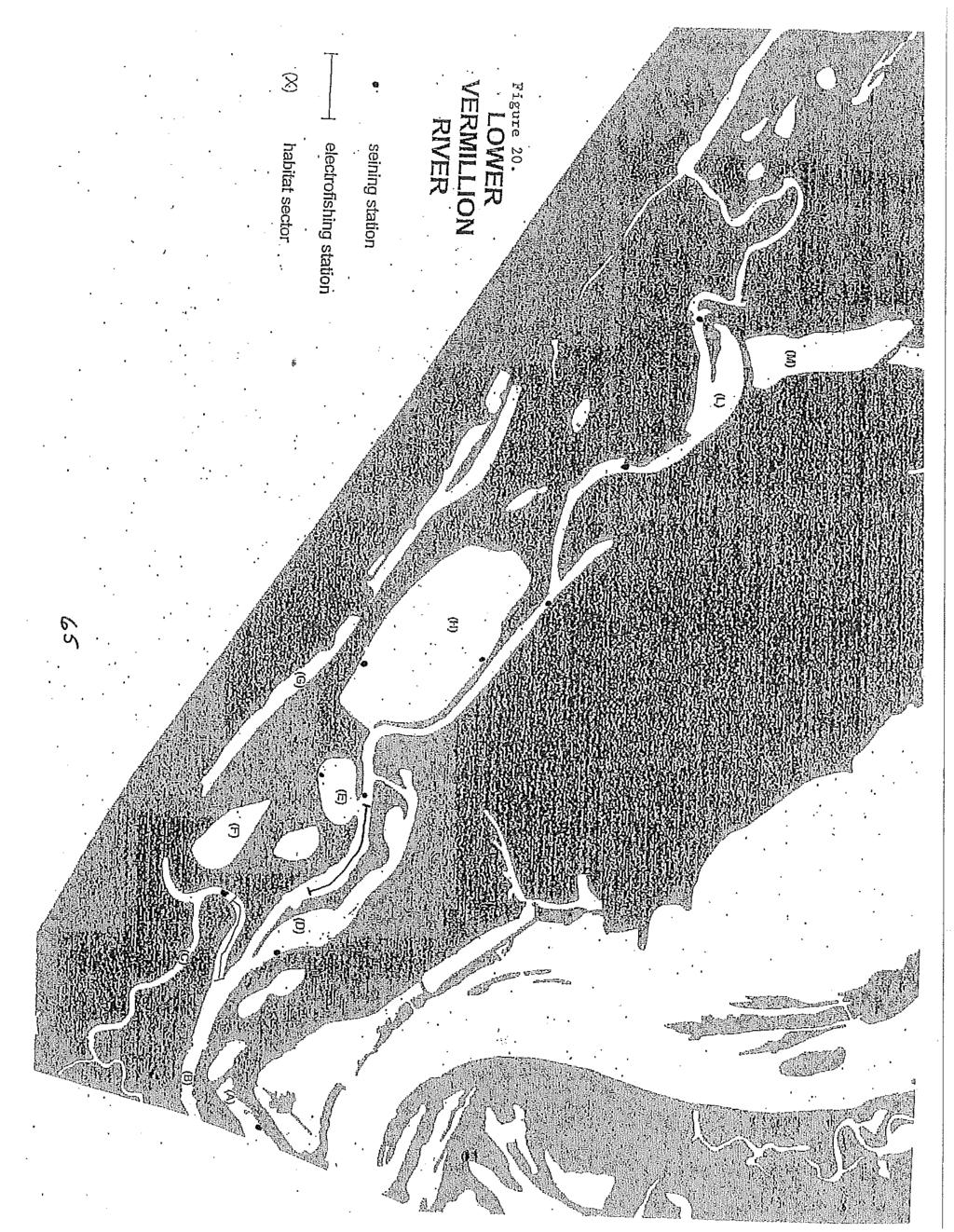
4 Keiselhorse Bay, Fountain City Bay, Thorpe s WMA, Schneider's Lakes, Twin Lakes, Burleigh Slough, Crooked Slough, and Polander Lake (Figures 6-7). In Pool 6, sampling was conducted in Blackbird Slough, Yeoman's Pond, Bathhouse Slough, Dugout Slough, Sam Gordy's Slough, Swift Creek/Blacksmith Slough Complex, LaMoille Island and the lower pool impounded area, containing Trempealeau Island (Figures 9-11). In Pool 7, sampling was conducted in and around Richmond Island, Pigeon Island, Big Marsh, Bullet Chute, Sommers Chute, Lake Onalaska, and the lower pool island complex between Dakota and Dresbach, MN (Figures 13-14). In the MN portion of Pool 9 sampling was conducted throughout the Reno Bottoms Area including Running Slough, Pickeral Slough, Hayshore Lake, Ice Haul Slough, Visgar's Slough, and Minnesota Slough (Figure 16). In the LVR, sampling was conducted in Duschene s Slough, Upper and Lower Clear Lakes, Goose Lake, Indian Slough, Nelson Lake, Birch Lake, Catfish Slough, Buffalo Slough, and Pickerel Lake (Figures 18 20). (Vermillion River study area and sampling locations are further described in the "Lower Vermillion River Aquatic Habitat Survey"- Dieterman 1995). METHODS Habitat Sampling Habitat sampling was conducted in Pools 3, 5, 5a, 6, 7, upper 9 and LVR June 26 to July 28. Late June through early August represents the period of peak biomass for most aquatic and semi-aquatic vegetation in this part of the UMR. An Aquatic Habitat Quality Index (AHQI) was developed in 2001 to better quantify habitat quality and to provide a method for evaluating long-term changes within a relatively large 2
5 geographical portion of the UMR (Dieterman 2001). Habitat assessments from were conducted similar to assessments made from , and fitted to the AHQI to provide a more consistent long-term perspective. This index is based on a qualitative assessment of submerged and floating aquatic and semi-aquatic vegetation species diversity and density, bathymetric diversity, substrate composition, and water quality within a predetermined area (sector). Using this method, it is possible to determine aquatic habitat quality in many areas in a relatively short time frame. AHQI scores have also been applied to a descriptive rating curve. Ranges of AHQI scores and associated aquatic habitat quality measures are provided below. Aquatic Habitat Quality AHQI Scores Excellent Good Fair 9-13 Poor 5-8 Very Poor 0-4 Fish Sampling Shoreline seining was conducted August in Pools 3, 5, 5a, 6, 7, 9 and LVR Using a 1/8" mesh, 50' x 6' bag seine. Seining procedures and data collection followed the instructions provided in the 1992 MN DNR Lake Survey Manual (Schlagenhaft et al. 1993). All fish collected were identified and counted. All gamefish and gizzard shad, including young-of-the-year (YOY), were measured in millimeters. This effort is conducted annually to provide information on fish recruitment, relative abundance (number/acre seined), and species richness. 3
6 A catfish sampling effort utilizing low-frequency electrofishing (EF) was initiated in Individual pools are sampled on rotation every two years. Electrofishing was conducted using a boat equipped with Smith-Root components operating pulsed direct current (DC), set at pulses per second (pps), 30% duty cycle, producing 1-2 amps. A 2-foot diameter array of dropper cables attached to fiberglass poles extending from the front of the boat functioned as anodes, and the hull of the boat functioned as the cathode. In 2008, sampling was conducted along secondary and main channel border habitats in Pool 5A during daylight hours on June 2 and 3 at water temperatures ranging from degrees Fahrenheit ( F). Sampling stations were one-half mile in length and were chosen randomly at a ratio of 1:4 or 1:5 from all available one-half mile long stations along both left and right descending banks in secondary and main channel habitats (Figures 6 7). Catch data and catch per unit of effort (CPUE), reported as number/mile were used to determine length frequency distributions and relative abundance. All flathead and channel catfish collected were measured in millimeters (mm) and weighed in grams (g). Sturgeon sampling with trammel nets and angling gear was initiated in 2007 to increase our knowledge and understanding of relatively unexploited populations of shovelnose sturgeon and recovering populations of lake sturgeon. In 2008, multifilament trammel nets (100 x 6 ) with outer and inner panels consisting of 1 foot and 2-inch mesh, respectively, were used below Lock and Dam 2 from September 23-30, and below Lock and Dam 3 from August 4-8. Nets were drifted for minutes in the tailwater area below the dams where flow is most concentrated. The net was aided in drift by the use of mules (wooden structures designed to catch the current and pull the net). The trammel net was fished in the same location multiple times 4
7 during the day. After each net drift all sturgeon were measured and weighed. Sampling with terminal tackle was conducted in upper Pool 4 on 7 sampling days for 58 hours of effort. All lake sturgeon were measured and weighed and tagged near the dorsal fin using disc-dangler tags. Catch data was reported as number/set or number/hr, and was also used to develop length frequency distributions. Pectoral fin rays were removed from a subsample of fish for age and growth analysis (Koch and Quist 2007) (Koch et. al. 2008). In Pools 3, 5, 5A, 6, 9, and LVR, fish were sampled by EF October 31 November 17. Fall EF was conducted using the same boat and component configuration as mentioned for the catfish sampling effort, however, sampling during this effort was conducted using pulsed DC set at 40 pps at 25% duty cycle, producing 3 6 amps. Electrofishing was conducted during daylight hours at water temperature ranging from 38 to 43 F. Sampling was conducted for either a predetermined distance or time interval, and the time was recorded for each run. All sizes of fish from the families: Esocidae, Percidae, Centrarchidae and Ictaluridae were collected and measured in millimeters (mm). Catch data and CPUE were used to determine length frequency distributions and relative abundance. Relative stock densities (Anderson and Nuemann 1996) of bluegill from both the MN and WI sides of Pools 5 and 5A were also calculated from catch data since Scale and otolith samples were taken from bluegills captured in Pool 5 and 5A for use in growth analysis, and to aid in the evaluation of experimental regulations. The following table summarizes electrofishing effort by pool: 5
8 Electrofishing November 2008 Pool # runs Temp.( F) Total run time (hrs.) a Did not sample in LVR Maps for all locations surveyed were made from 2000 Land Cover/Land Use maps using ArcMap 9.2. Habitat sectors and fisheries sampling locations are identified on each figure. Daily discharge measurements from U.S. Army Corps of Engineers (USACE) gauges at locks and dams were used to develop hydrographs. RESULTS AND DISCUSSION Climatic conditions throughout the region were colder and wetter than normal during winter and early spring The spring flood in our study reach peaked at levels near the historic average, but occurred on or near May 10, which was 2-3 weeks later than average (Figures 2, 5, 8, 12, 15, 17). However, extensive widespread and historic rainfall and flooding during June occurred in much of the watershed south of our study reach, including much of Iowa, southern Wisconsin and Illinois. Water temperatures during the spring flood (mid-april to mid-may) were generally below 6
9 normal for this time of year. Below average temperatures during and after peak spawning for many species of fish had a profound effect on their recruitment in Relatively poor survival and recruitment of YOY gizzard shad, emerald shiner, bullhead minnow and walleye were documented during seining efforts in August and electrofishing in October and November. Precipitation and temperature patterns during summer and fall were generally normal and ambient water temperatures were near optimal for growth of most fish species. Ice first formed in backwaters during the last week of November and ice-anglers were fishing the smaller, more isolated backwater areas by December 1. November and December were wetter and colder than normal. Fish populations between Hastings, MN and the Iowa border are generally in good to excellent shape. Annual recruitment and growth of most fish species has been generally good since However, seining CPUE for YOY bluegill and some important forage species (ie. gizzard shad, emerald shiner, and bullhead minnow) were below the 16-year mean in almost all pools surveyed in 2008 (Tables 1, 8, 13, 19, 22, 27, 30). Low frequency EF in Pool 5A during early June revealed a healthy population of flathead catfish, with a CPUE of 8.6/mi (Table 2). Trammel netting proved very effective for sampling adult shovelnose sturgeon and juvenile lake sturgeon in the tailwaters of LD 2 (Pool 3) and LD 3 (Pool 4) (Table 31). Combined with angling catch, a total of fifty-seven lake sturgeon were collected and tagged in Pool 4 (Table 32). Fall electrofishing CPUE for bluegill and largemouth bass was above the sixteen-year mean in all pools sampled (Tables 3-4). Habitats and general locations, diseases, and species of concern include: the entire MN/WI border waters for the imminent threat of Asian carp, specifically bighead 7
10 and silver carp, which were captured in a commercial seine haul in Pool 8 (2 bigheads and 1 silver) in November and in additional seine hauls from pools 5A, 8, and 9 in January and March 2009; Pool 3 and LVR backwaters and centrarchid populations, which continue to reflect poor habitat conditions; potential impacts of large cormorant and pelican populations; Cyprinid populations, which are susceptible to infection by Spring Viremia, previously found in common carp in 2002; Largemouth bass virus (LMBV), which has been documented in pools 3, 7, 8, 10 and 11, is associated with high mortality rates in confined groups of largemouth bass (i.e. tournament weigh-ins); and Viral Hemorrhagic Septicemia (VHS) which has been responsible for large fish kills and has been documented in the Great Lakes and inland waters of Wisconsin. The following information provides a general description of habitat conditions and fish populations sampled in each pool in POOL 3 Deltaic activity and the formation of islands, sand bars, mud flats, flowing channels and protected bays at the outlets of secondary channels in North and Sturgeon lakes produced a diversity of habitat types and conditions that were utilized by many fish and wildlife species. Aquatic habitat conditions appear to have stabilized somewhat after three consecutive years of slight improvements. Submerged aquatic vegetation abundance and diversity is predominantly limited to the more isolated bays and delta areas in North and Sturgeon lakes. The mean AHQI score for North Lake was 12.8 (Table 6), which places it in the Fair category. Twenty-six species of fish were collected by shoreline seining from twelve locations (Figure 1 and Table 1). Seining CPUE for YOY bluegill, black crappie and 8
11 largemouth bass improved somewhat in 2008, but was still considered relatively poor (Table 8). Electrofishing CPUE for adult bluegill, crappie and largemouth bass was above the long-term mean and is likely responsible for the observed increase in seining CPUE for YOY centrarchids as well (Table 4). POOL 5 Aquatic habitat conditions were generally good to excellent throughout the pool. Submerged aquatic vegetation was moderate - dense and highly diverse in most aquatic areas surveyed. Mean AHQI scores from geographically defined areas larger than 100 acres surpassed the highest scores recorded since sampling began in 1993 for the second straight year, and ranged from 16 in the Minneiska Flats to 19.3 in the Lost Island area (Table 9). Species diversity was greatest in partially isolated backwaters and in shallow water (< 3 feet) where substrates and flows were variable. Active tertiary channel migration and subsequent sediment deposition and scour were prevalent throughout middle and lower portions of the pool (i.e. Weaver-sectors B and C, Kruger Slough-sectors F and G). Twenty-nine species of fish were collected by shoreline seining from twenty-four locations (Figures 3, 4 and Table 1). Of particular interest was the relative absence of important forage species (i.e. gizzard shad, emerald shiner and bullhead minnows) that are usually the most abundant group of fishes collected (Table 13). Electrofishing CPUE for bluegill, largemouth bass and yellow perch was higher than the long-term mean for the 6 th consecutive year, but CPUE for black crappie was lower than the longterm mean for the 2 nd consecutive year (Table 4). Adult bluegill populations were dominated by age 2 and 3 year-old fish, but all ages up to 8 years old were represented 9
12 (Tables 11 and 12). Relative Stock Density (RSD) values for bluegill > 7 inches improved in 2008 to 31 in MN waters and 25 in WI waters (Table 5). POOL 5A Aquatic habitat conditions throughout the pool were good to excellent. Previously surveyed areas containing submerged and emergent vegetation remain relatively unchanged, and vegetation beds were similar in diversity and spatial distribution. Mean AHQI scores from geographically defined areas larger than 100 acres ranged from 12.0 in Denzer s Meadow to 18.8 in the Twin Lakes complex (Table 14). Active tertiary channel migration and subsequent sediment deposition and scour were prevalent throughout the Twin Lakes and upper Polander Lake complex. Twenty-four species of fish were collected by shoreline seining from sixteen locations (Figures 6, 7 and Table 1). Seining CPUE for bluegill, largemouth bass, and all species combined was near the 16-year mean, but was very low for important forage species (i.e. gizzard shad, emerald shiner and bullhead minnow) (Table 19). Electrofishing CPUE was affected by a significant cold front that formed ice in many locations and prevented sampling in many stations. However, length frequency distributions of fish captured by both electrofishing and angling from a few locations indicate healthy populations of bluegill, largemouth bass and crappie (Table 3). Similar to Pool 5, the adult bluegill population is dominated by age 2 and 3 year-old fish, but only fish up to 5 years of age were represented in the sample (Tables 17 and 18). POOL 6 Aquatic habitat conditions throughout Pool 6 were generally excellent. An extensive flood control levee system surrounding Winona, MN, and the Burlington 10
13 Northern Railroad, which bisects the floodplain along the Wisconsin border, have constricted the floodplain so that much of the aquatic habitat in Pool 6 is lotic in nature. Good water quality and active secondary and tertiary channel migration and subsequent sediment deposition and scour were prevalent within middle and lower portions of the pool, resulting in abundant and diverse aquatic and semi-aquatic vegetation and habitat. Mean AHQI scores for delineated backwater areas larger than 40 acres were collectively very similar to the all time high measured in 2006, and ranged from 13.0 in Blackbird Slough to a 21.0 in Blacksmith Slough (Table 20). Twenty species of fish were collected by shoreline seining from fourteen locations (Figures 9, 10, 11 and Table 1). Seining CPUE for bluegill, black crappie and largemouth bass was well below the 16-year mean for each species, and was the fourth consecutive year in which this has been observed (Table 22). As in Pools 5 and 5A, CPUE for important forage species was also very low, and in the case of gizzard shad and emerald shiners, none were sampled. Populations of forage species will be closely monitored in 2009 and if CPUE remains low, factors affecting these populations will be examined further. Electrofishing CPUE for adult bluegill, largemouth bass, and yellow perch however, was above the 16-year mean for the third consecutive year, suggesting that either the seining effort is grossly under sampling year classes, or that fish are emigrating into the pool from adjacent pools or non-sampled connected areas (i.e. Airport Lake complex and/or Mud Lake complex) (Table 4). POOL 7 Pool 7 contained a very diverse submerged and emergent vegetation community and aquatic habitat conditions were excellent throughout the pool. Mean AHQI scores 11
14 for delineated backwater areas larger than 40 acres ranged from 13.5 in Web Slough to 21.0 in the interior of Pigeon Island (Table 23). The only fisheries monitoring conducted in 2008 was seining, in which twenty species of fish were collected from eleven locations (Figures and Table 24). As in other upstream pools, CPUE for important forage species was low. POOL 9 Contiguous backwater areas in upper Pool 9 continue to fill with sand and silt, a result of an elevation difference between the main channel and backwaters of Reno Bottoms. High water events in 1993, 1997, and 2001 breached the natural levee along the main channel and caused extensive erosion within high-flow channels. As a result of the difference in head, substantial head cutting also occurred. This hydraulic change allowed the formation of larger tertiary channels capable of transporting more flow and sediment. These tertiary channels deposited a large amount of sand into backwater lakes of the Reno bottoms. With the addition of larger diameter sediment particles and increased flow, problems associated with re-suspension of fine sediments were reduced. A reduction in suspended solid concentrations allowed for better light penetration and increased coverage and density of submerged aquatic vegetation. Mean AHQI scores for contiguous backwater areas larger than 50 acres ranged from 12.0 in Ice Haul Slough to 14.2 in Hayshore Lake (Table 25). The MN portion of upper Pool 9 contains diverse habitats capable of supporting good populations of fish assemblages favoring both lotic and lentic environments. However, lentic habitat, in the form of contiguous backwater lakes and sloughs, is shrinking rapidly due to the effects of sedimentation. 12
15 Twenty-three species of fish were collected by shoreline seining from eight locations (Figure 16 and Table 1). Seining CPUE for bluegill and black crappie was below the 15-year mean for the second consecutive year, and as in upstream pools, low for gizzard shad and emerald shiners (Table 27). Electrofishing CPUE for gamefish commonly found in these waters, including bluegill, largemouth bass, northern pike, yellow perch, and walleye was above the 15-year mean (Table 4). Based on CPUE and length frequency distribution tables, healthy populations with multiple age classes exist in upper Pool 9. Lower Vermillion River Habitat conditions were similar to what has been observed since annual monitoring began in Water quality within the channel and in contiguous backwaters continues to reflect problems associated with fine sediment deposition and frequent re-suspension of sediments due to wind/wave action and fish activity. AHQI scores from contiguous backwater areas ranged from 4.0 in Pickerel Lake to 7.0 in Catfish slough (Table 28). In contrast, isolated backwater areas are not as subject to the causes of sediment re-suspension, and abundant and diverse submerged aquatic and emergent exists. Mean AHQI scores from isolated backwater areas typically range from 14 17, and in 2008 the only site surveyed (Nelson Lake) scored 16 (Table 28). Fish populations in 2008, as measured by EF, were above average and represented by a diverse assemblage. Annual and seasonal movement of fish within the immediate floodplain and between this complex and upper Pool 4 and Pool 3 helps maintain the fishery and demonstrates the importance of lateral and longitudinal floodplain and tributary connectivity in large floodplain rivers. Thirteen species of fish were collected by shoreline seining from ten locations (Figure 20 and Table 1). Seining 13
16 CPUE for YOY bluegill, black and white crappie and important forage species (i.e. gizzard shad, emerald shiners, and bullhead minnows), was below the 14-year mean, however, CPUE for YOY northern pike was above the mean (Table 30). Electrofishing CPUE for gamefish (i.e. northern pike, bluegill, largemouth bass, yellow perch and walleye) was above the 14-year mean (Table 4). SUMMARY Aquatic and floodplain habitat conditions throughout Pools 5 9 were generally good to excellent, and similar to what has been observed and measured over the past few years. Gamefish populations are generally healthy and abundant. Substantial flooding and high base flows throughout the 1990 s and early 2000 s, coupled with relatively low water levels during the start of the growing season in recent years appears to have played a significant role in the relatively healthy ecological condition that currently exists on much of the UMR bordering Minnesota, Wisconsin, and Iowa. The large floods in 1993, 1997 and 2001 significantly redistributed sediments and nutrients, stimulating biological productivity in shallow aquatic and semi-aquatic habitat. Seasonal hydrologic variation produces dynamic and diverse spatial and temporal habitat that is critical in sustaining the ecological health of the UMR. The existing system is predominantly managed to maintain consistent depths, which support navigation but restrict seasonal hydrologic variation. Water level management is an alternative that allows resource managers to emulate summer low-flow conditions and promotes hydrologic variation. Continued annual sampling will improve our ability to identify and analyze trends, and information will be presented to citizens and decision makers so that informed decisions are made when management issues arise. 14
17 ACKNOWLEDGEMENTS Kevin Stauffer, Randy Binder, Jeff Weiss and Jon Meerbeek, assisted with fieldwork. Water elevation data was obtained from the USCOE. Jon Meerbeek, Kevin Stauffer and Jeff Weiss provided editorial assistance. REFERENCES Anderson, R. O., and Neumann, R. M Length, Weight, and Associated Structural Indices. Pg in B. R. Murphy and D. W. Willis, editors. Fisheries Techniques, 2 nd edition. American Fisheries Society, Bethesda, MD. Dieterman, D.M Major River Survey, Backwaters of Upper Mississippi River Pools 3, 5, 5A, 6 and 9, MN Dept. Nat. Res., Div. Fish. Wildl., Sect. Fish. Stream Survey Report Dieterman, D.M Major River Survey, Backwaters of Upper Mississippi River Pools 3, 5, 5A, 6 and 9 and the Lower Vermillion River, MN Dept. Nat. Res., Div. Fish. Wildl., Sect. Fish. Stream Survey Report Dieterman, D.M Major River Survey, Upper Mississippi River Pools 3, 5, 5A, 6, 7, Upper 9 and the Lower Vermillion River, MN Dept. Nat. Res., Div. Fish. Wildl., Sect. Fish. Stream Survey Report Koch, J. D. and M. C. Quist A technique for preparing fin rays and spines for age and growth analysis. North American Journal of Fisheries Management 27: Koch, J. D., W. J. Schreck, and M. C. Quist Standardized removal and sectioning locations for shovelnose sturgeon fin rays. Fisheries Management and Ecology 15: Schlagenhaft, T. et. al Manual of Instructions for Lake Survey. MN Dept. Nat. Res., Div. Fish. Wildl., Sect. Fish. Special Publication
18
19
20
21
22
23
24
25
26
27
28
29

30
31
32
33
34
35
36
37
38
39
40
41
42
43
44
45
46
47
48
49
50
51
52
53
54
55
56
57
58
59

60
61
62
63
64

65

66
67
68
69
70
71
72
73
74
MISSISSIPPI MAKEOVER A Plan for Restoration, Just Around the Bend
 MISSISSIPPI MAKEOVER A Plan for Restoration, Just Around the Bend Interim Report Card 2013 Project coordinated by the Dakota County Soil and Water Conservation District and sponsored by the Minnesota Pollution
Current Status and Management Recommendations for the Fishery in the Cloverleaf Chain of Lakes
 Current Status and Management Recommendations for the Fishery in the Cloverleaf Chain of Lakes Jason Breeggemann Senior Fisheries Biologist Wisconsin Department of Natural Resources Outline DNR fisheries
Proposed Changes to Bag and Size Limits Minnesota/Wisconsin Border Waters of the Mississippi River
 Proposed Changes to Bag and Size Limits Minnesota/Wisconsin Border Waters of the Mississippi River The Minnesota and Wisconsin DNRs are jointly reviewing fishing regulations on Pools 3-9 of the Mississippi
Cedar Lake Comprehensive Survey Report Steve Hogler and Steve Surendonk WDNR-Mishicot
 Cedar Lake- 2006 Comprehensive Survey Report Steve Hogler and Steve Surendonk WDNR-Mishicot ABSTRACT Cedar Lake is a 142 acre lake located in the southwest corner of Manitowoc County. It is a seepage lake
MARTINDALE POND Wayne County 2004 Fish Management Report. Christopher C. Long Assistant Fisheries Biologist
 MARTINDALE POND Wayne County 2004 Fish Management Report Christopher C. Long Assistant Fisheries Biologist Fisheries Section Indiana Department of Natural Resources Division of Fish and Wildlife I.G.C.
Introduction: JadEco, LLC PO BOX 445 Shannon, IL 61078
 Introduction: was contacted to collected data on the fishery for Lake Holiday. AC Electroshocking was conducted at 2 locations on September 28, 2015. Fish population data was collected for a total of 100
MIDDLE FORK RESERVOIR Wayne County 2004 Fish Management Report. Christopher C. Long Assistant Fisheries Biologist
 MIDDLE FORK RESERVOIR Wayne County 2004 Fish Management Report Christopher C. Long Assistant Fisheries Biologist FISHERIES SECTION INDIANA DEPARTMENT OF NATURAL RESOURCES DIVISION OF FISH AND WILDLIFE
JadEco, LLC PO BOX 445 Shannon, IL 61078
 Introduction: With the assistance of Lake Holiday staff and volunteers, we were able to conduct an AC electrofishing survey on May 8, 27. Water temperatures were 2.3 C (8.5 F) and water clarity was decent
MINNESOTA DEPARTMENT OF NATURAL RESOURCES DIVISION OF FISHERIES AND WILDLIFE. Gamefish Assessment Report
 Minnesota DNR F-29-R(P) Area F312 February 1, 2013 MINNESOTA DEPARTMENT OF NATURAL RESOURCES DIVISION OF FISHERIES AND WILDLIFE Gamefish Assessment Report Spring Gamefish Assessment on the Mississippi
An Assessment of the Fish Community in Lake Acworth
 An Assessment of the Fish Community in Lake Acworth By John Damer Fisheries Biologist Georgia Department of Natural Resources Wildlife Resources Division Fisheries Section Calhoun, GA 30701 July 2008 Introduction
2014 Island Lake Survey June 13 th, 2014 Andrew Plauck District Fisheries Biologist Report Prepared 4 March 2015
 2014 Island Lake Survey June 13 th, 2014 Andrew Plauck District Fisheries Biologist Report Prepared 4 March 2015 BACKGROUND - A fish survey was requested due to a moderately severe winterkill in Island
LAKE DIANE Hillsdale County (T8-9S, R3W, Sections 34, 3, 4) Surveyed May Jeffrey J. Braunscheidel
 Surveyed May Jeffrey J. Braunscheidel") Michigan Department of Natural Resources Status of the Fishery Resource Report No. 2003-4, 2003 LAKE DIANE Hillsdale County (T8-9S, R3W, Sections 34, 3, 4) Surveyed May 2001 Jeffrey J. Braunscheidel Environment
Michigan Department of Natural Resources Status of the Fishery Resource Report No. 2003-4, 2003 LAKE DIANE Hillsdale County (T8-9S, R3W, Sections 34, 3, 4) Surveyed May 2001 Jeffrey J. Braunscheidel Environment
Little Calumet River Rapid Response Fish Identification and Enumeration Branch Summary Report
 Little Calumet River Rapid Response Fish Identification and Enumeration Branch Summary Report Introduction A rotenone rapid response was completed on a 2.6-mile section of the Little Calumet River immediately
Fish Survey of Arctic Lake (ID # ), Scott County, Minnesota in 2012
, Scott County, Minnesota in 2012") Snapping Turtle from Arctic Lake, September 2012 Fish Survey of Arctic Lake (ID #70-0085), Scott County, Minnesota in 2012 Survey Dates: September 18-20, 2012 MnDNR Permit Number: 18362 Prepared for: Shakopee
Snapping Turtle from Arctic Lake, September 2012 Fish Survey of Arctic Lake (ID #70-0085), Scott County, Minnesota in 2012 Survey Dates: September 18-20, 2012 MnDNR Permit Number: 18362 Prepared for: Shakopee
Minnesota Department of Natural Resources Division of Fish and Wildlife Section of Fisheries. Stream Survey Report. Luxemburg Creek.
 Minnesota F-29-R(P)-24 Area 315 Study 3 March 2016 Minnesota Department of Natural Resources Division of Fish and Wildlife Section of Fisheries Stream Survey Report Luxemburg Creek 2015 Mark Pelham Sauk
Caro Impoundment, Tuscola County
 Caro Impoundment is a 200 acre impoundment of the Cass River located one mile south of the Village of Caro in Tuscola County. Caro Dam, originally constructed in 1906 for water supply to Michigan Sugar
SOONER LAKE MANAGEMENT PLAN
 SOONER LAKE MANAGEMENT PLAN Background Lake Sooner impounds Greasy Creek, 15 miles south of Ponca City in Noble and Pawnee Counties, Oklahoma (Figure 1). The Grease Creek basin that Sooner Lake impounds
2017 Lake Winnebago Bottom Trawling Assessment Report
 217 Lake Winnebago Bottom Trawling Assessment Report Adam Nickel, Winnebago System Gamefish Biologist, March 218 There were several highlights from the 217 Lake Winnebago bottom trawling survey, including
Lake Butte des Morts Commercial Seining Project Report
 Lake Butte des Morts Commercial Seining Project Report Adam Nickel, Winnebago Gamefish (excluding sturgeon) Biologist, 22 December 2014 Conducting comprehensive fish surveys on the Upriver Lakes, including
LITTLE WHITE OAK Knox County 2006 Fish Management Report. Debbie King Assistant Fisheries Biologist
 LITTLE WHITE OAK Knox County 2006 Fish Management Report Debbie King Assistant Fisheries Biologist Fisheries Section Indiana Department of Natural Resources Division of Fish and Wildlife I.G.C.-South,
CORRESPONDENCE/MEMORANDUM
 CORRESPONDENCE/MEMORANDUM State of Wisconsin DATE: November 13, 2012 FILE REF: [Click here and type file ref.] TO: FROM: Mike Donofrio Harpt Lake File Steve Hogler SUBJECT: 2012 Harpt Lake Electrofishing
NURSERY POND Fish Management Report. Jason C. Doll Assistant Fisheries Biologist
 NURSERY POND 2004 Fish Management Report Jason C. Doll Assistant Fisheries Biologist FISHERIES SECTION INDIANA DEPARTMENT OF NATURAL RESOURCES DIVISION OF FISH AND WILDLIFE I.G.C. South, Room W273 402
Fisheries Survey of White Rapids Flowage, Marinette County Wisconsin during Waterbody Identification Code
 Fisheries Survey of White Rapids Flowage, Marinette County Wisconsin during 25 Waterbody Identification Code 6343 Michael Donofrio Fisheries Supervisor Wisconsin Department of Natural Resources Peshtigo,
Warmwater Fisheries Assessments 2014
 NJDEP Division of Fish and Wildlife Bureau of Freshwater Fisheries Warmwater Fisheries Assessments 2014 New Jersey has over 400 impoundments open to the general public for fishing and thousands more in
INLAND LAKE MANAGEMENT REPORT FY Spring 2008
 INLAND LAKE MANAGEMENT REPORT FY 2008 Spring 2008 Prepared by Robert O. Andress District Fisheries Biologist E. Daniel Catchings District Fisheries Supervisor Kevin W. Baswell District Biologist Aide Department
Minnesota Department of Natural Resources Division of Fisheries and Wildlife
 Minnesota Department of Natural Resources Division of Fisheries and Wildlife Completion Report Evaluation of Centrarchid Populations throughout Leech Lake 215 by Matt Ward Walker Area Fisheries Office
SKIATOOK LAKE MANAGEMENT PLAN
 SKIATOOK LAKE MANAGEMENT PLAN Background Skiatook Lake impounds Hominy Creek, 5 miles west of Skiatook in Osage County, Oklahoma (Figure 1). Skiatook Lake covers 10,540 surface acres and was constructed
Fisheries Survey of Saratoga Lake
 Fisheries Survey of Saratoga Lake 7- Mark D. Cornwell Kevin Poole State University of New York College of Agriculture & Technology Department of Fisheries & Wildlife Cobleskill, NY ABSTRACT: This survey
Michigan Dept. of Natural Resources Status of the Fishery Resource Report Page 1. Weber Lake Cheboygan County, T34N, R3W, Sec.
 Michigan Dept. of Natural Resources 2012-143 Status of the Fishery Resource Report Page 1 Weber Lake Cheboygan County, T34N, R3W, Sec. 31 Neal Godby, Fisheries Biologist Environment Weber Lake is a 28.5-acre
Big Bend Lake Population Survey
 Big Bend Lake Survey Located in Des Plaines on East River Rd. just south of Golf Rd. This 27 acre body of water has a depth of 27.8 feet; however because it is connected to the Des Plaines River by a spillway,
NEVADA DEPARTMENT OF WILDLIFE STATEWIDE FISHERIES MANAGEMENT
 NEVADA DEPARTMENT OF WILDLIFE STATEWIDE FISHERIES MANAGEMENT FEDERAL AID JOB PROGRESS REPORTS F-2-52 216 CHIMNEY RESERVOIR WESTERN REGION NEVADA DEPARTMENT OF WILDLIFE, FISHERIES DIVISION JOB PROGRESS
Minnesota Department of Natural Resources Division of Fish and Wildlife Section of Fisheries. Stream Survey Report. Cold Spring Creek.
 Minnesota F-29-R(P)-24 Area 315 Study 3 March 2015 Minnesota Department of Natural Resources Division of Fish and Wildlife Section of Fisheries Stream Survey Report Cold Spring Creek 2014 Mark Pelham Montrose
LAKE MANAGEMENT PLAN
 LAKE MANAGEMENT PLAN Region Area DOW Number County DOW Lake Name Acreage 2 Duluth F213 69-0041 St. Louis Bassett DOW: 436 Plan: 442 Long Range Goal: Manage for walleye with a gillnet catch rate greater
Regulations. Grabbling season May 1 July 15; only wooden structures allowed.
 Arkabutla Reservoir 219 REEL FACTS Keith Meals, Arthur Dunn, Stanley Turner Fisheries Biologists keithm@wfp.ms.gov, ArthurD@wfp.ms.gov, StanleyT@wfp.ms.gov General Information: Arkabutla Reservoir is one
Tunica Cutoff 2018 REEL FACTS Keith Meals Fisheries Biologist
 Tunica Cutoff 218 REEL FACTS Keith Meals Fisheries Biologist keithm@mdwfp.state.ms.us General Information: Tunica Cutoff was created by the US Army Corps of Engineers (COE) in 1942 when a bend in the Mississippi
Regulations. Grabbling season May 1 July 15; only wooden structures allowed.
 Grenada Reservoir 218 REEL FACTS Keith Meals, Arthur Dunn, Stanley Turner Fisheries Biologists keithm@mdwfp.state.ms.us, ArthurD@mdwfp.state.ms.us, StanleyT@mdwfp.state.ms.us General Information: Grenada
2015 Winnebago System Walleye Report
 215 Winnebago System Walleye Report Adam Nickel, Winnebago Gamefish Biologist, March 216 As winter passes in the rear view mirror, it won t be long until the spring rush of the 216 walleye run is here.
FACT SHEET I. LOCATION
 STEAMBOAT ISLAND HABITAT REHABILITATION AND ENHANCEMENT PROJECT (HREP) SCOTT COUNTY, IOWA, UPPER MISSISSIPPI RIVER RESTORATION-ENVIRONMENTAL MANAGEMENT PROGRAM ROCK ISLAND DISTRICT FACT SHEET I. LOCATION
BIG TWIN LAKE Kalkaska County (T28N, R05W, Section 18, and T28N, R06W, Section 13) Surveyed May 1999
 Surveyed May 1999") Michigan Department of Natural Resources Status of the Fishery Resource Report No. 2001-1, Year 2001 BIG TWIN LAKE Kalkaska County (T28N, R05W, Section 18, and T28N, R06W, Section 13) Surveyed May 1999
Michigan Department of Natural Resources Status of the Fishery Resource Report No. 2001-1, Year 2001 BIG TWIN LAKE Kalkaska County (T28N, R05W, Section 18, and T28N, R06W, Section 13) Surveyed May 1999
Penny Road Pond Population Survey
 Located in Barrington Hills on the south side of Penny Rd. west of Old Sutton Rd. This small 7 acre pond has a maximum depth of 4.6 feet and is connected to Spring Creek. The fish population of Penny Road
HUBBARD LAKE Alcona County (T27N, R7E; T28N, R7E) Surveyed May and September Tim A. Cwalinski
 Surveyed May and September Tim A. Cwalinski") Michigan Department of Natural Resources Status of the Fishery Resource Report No. 2003-1, 2003 HUBBARD LAKE Alcona County (T27N, R7E; T28N, R7E) Surveyed May and September 1996 Tim A. Cwalinski Environment
Michigan Department of Natural Resources Status of the Fishery Resource Report No. 2003-1, 2003 HUBBARD LAKE Alcona County (T27N, R7E; T28N, R7E) Surveyed May and September 1996 Tim A. Cwalinski Environment
FACT SHEET MCGREGOR LAKE RESTORATION HABITAT PROJECT POOL 10, UPPER MISSISSIPPI RIVER, WISCONSIN ENVIRONMENTAL MANAGEMENT PROGRAM
 FACT SHEET MCGREGOR LAKE RESTORATION HABITAT PROJECT POOL 10, UPPER MISSISSIPPI RIVER, WISCONSIN ENVIRONMENTAL MANAGEMENT PROGRAM LOCATION McGregor Lake is located within a mid-river island in Pool 10
Minnesota Department of Natural Resources Division of Fish and Wildlife Section of Fisheries. Stream Survey Report. Three Mile Creek 2011
 Minnesota Department of Natural Resources Division of Fish and Wildlife Section of Fisheries Stream Survey Report Three Mile Creek 2011 By Joseph D. Stewig Montrose Area Fisheries Office TABLE OF CONTENTS
O Malley s Ponds Population Survey
 O Malley s Ponds Survey The newest fishing lake within the Forest Preserves of Cook County, O Malley Ponds were acquired by the District in 2005. Located in Sauk Village at the intersection of Sauk Trail
Current projects for Fisheries Research Unit of Minnesota Department of Natural Resources
 Current projects for Fisheries Research Unit of Minnesota Department of Natural Resources MAJOR RESOURCE ISSUES IN THE DIVISION OF FISHERIES Status of Fish Populations To effectively manage fish populations,
Quemahoning Reservoir
 Pennsylvania Fish & Boat Commission Biologist Report Quemahoning Reservoir Somerset County May 2011 Trap Net, Gill Net and Electrofishing Survey Quemahoning Reservoir is an 899 acre impoundment located
RECREATIONAL PONDS AND LAKES
 RECREATIONAL PONDS AND LAKES POND ECOLOGY AQUATIC PLANTS & FISH F.S. Conte Department of Animal Science University of California Davis Photos By Flickr AQUATIC PLANTS POND HEALTH Chemical Recycling Oxygen
East Metro Forest Lake (2,251 acres): Coon Lake (1,481 acres):
: Coon Lake (1,481 acres):") East Metro Forest Lake (2,251 acres): Located within the City of Forest Lake and just east of Interstate 35, Forest Lake boasts good numbers of northern pike and walleye. Northern pike and walleye were
East Metro Forest Lake (2,251 acres): Located within the City of Forest Lake and just east of Interstate 35, Forest Lake boasts good numbers of northern pike and walleye. Northern pike and walleye were
Regulations. Grabbling season May 1 July 15; only wooden structures allowed.
 Sardis Reservoir 218 REEL FACTS Keith Meals, Arthur Dunn, Stanley Turner Fisheries Biologists keithm@mdwfp.state.ms.us, ArthurD@mdwfp.state.ms.us, StanleyT@mdwfp.state.ms.us General Information: Sardis
Manual of Fisheries Survey Methods II: with periodic updates. Chapter 22: Guidelines for Sampling Warmwater Rivers with Rotenone
 Manual of Fisheries Survey Methods II: with periodic updates : Guidelines for Sampling Warmwater Rivers with Rotenone P. W. Seelbach, G. L. Towns, and D. D. Nelson Suggested citation: Seelbach, Paul W.,
2010 Fishing Opener Prognosis. Central Region
 2010 Fishing Opener Prognosis Central Region Hinckley PINE COUNTY Pokegama, Cross, Island, Oak and North and South Big Pine Lakes are typically the best lakes for targeting walleye in Pine County. They
Regulations. Grabbling season May 1 July 15; only wooden structures allowed.
 Enid Reservoir 218 REEL FACTS Keith Meals, Arthur Dunn, Stanley Turner Fisheries Biologists keithm@mdwfp.state.ms.us, ArthurD@mdwfp.state.ms.us, StanleyT@mdwfp.state.ms.us General Information: Enid Reservoir
Rat Cove and Brookwood Point littoral fish survey, 2002
 Rat Cove and Brookwood Point littoral fish survey, 2 Katie Wayman 1 INTRODUCTION During the summer of 2, efforts to monitor the Otsego Lake littoral fish community continued with trap netting at both Rat
Crooked Lake Oakland County (T4N, R9E, Sections 3, 4, 9) Surveyed May James T. Francis
 Surveyed May James T. Francis") Michigan Department of Natural Resources Status of the Fishery Resource Report No. 2004-1, 2004 Crooked Lake Oakland County (T4N, R9E, Sections 3, 4, 9) Surveyed May 2002 James T. Francis Environment Crooked
Michigan Department of Natural Resources Status of the Fishery Resource Report No. 2004-1, 2004 Crooked Lake Oakland County (T4N, R9E, Sections 3, 4, 9) Surveyed May 2002 James T. Francis Environment Crooked
Lake St. Clair Fish Community and Fishery
 Lake St. Clair Fish Community and Fishery Megan Belore Ontario Ministry of Natural Resources and Forestry Mike Thomas Michigan Department of Natural Resources Fish Community Fish Community Mixture of warm
Regulations. Grabbling season May 1 July 15; only wooden structures allowed.
 Sardis Reservoir 19 REEL FACTS Keith Meals, Arthur Dunn, Stanley Turner Fisheries Biologists keithm@wfp.ms.gov, ArthurD@wfp.ms.gov, StanleyT@wfp.ms.gov General Information: Sardis Reservoir is one of four
Results of the 2015 nontidal Potomac River watershed Smallmouth Bass Young of Year Survey
 Results of the 2015 nontidal Potomac River watershed Smallmouth Bass Young of Year Survey Natural reproduction of smallmouth bass in the nontidal Potomac River mainstem has been assessed annually since
Minnesota Department of Natural Resources Division of Fish and Wildlife Section of Fisheries
 Minnesota F-29-R(P)-27 Area 315 Study 3 May 20, 2009 Minnesota Department of Natural Resources Division of Fish and Wildlife Section of Fisheries Mississippi River Smallmouth Bass Regulation Evaluation
Gamefish Assessment Report
 MINNESOTA DEPARTMENT OF NATURAL RESOURCES Gamefish Assessment Report Spring Gamefish Assessment on the Mississippi River from Little Falls to Brainerd, MN May 31 through June 4, 2013 River Miles 966 to
Sag Quarry - West Population Survey
 Located in Lemont on RT 83 and Archer Ave. just north of 111 th St. Like Sag Quarry East, this lake is an old limestone quarry, 14 acres in size and with a maximum depth of 10.3 feet. The species found
Fish Survey of Goose Lake (ID # ), Ramsey County, Minnesota in 2012
, Ramsey County, Minnesota in 2012") Softshell Turtle from Goose Lake, July 2012 Fish Survey of Goose Lake (ID #62-0034), Ramsey County, Minnesota in 2012 Survey Dates: July 16-18, 2012 MnDNR Permit Number: 18362 Prepared for: VLAWMO and
Softshell Turtle from Goose Lake, July 2012 Fish Survey of Goose Lake (ID #62-0034), Ramsey County, Minnesota in 2012 Survey Dates: July 16-18, 2012 MnDNR Permit Number: 18362 Prepared for: VLAWMO and
Status Review and Management Outline for Quality Bluegill and Black Crappie Populations in the Grand Rapids Area.
 Status Review and Management Outline for Quality Bluegill and Black Crappie Populations in the Grand Rapids Area. Revised in 2013 By David L. Weitzel Assistant Area Fisheries Supervisor MN DNR, Grand Rapids
Pennsylvania Fish & Boat Commission Biologist Report. Wilmore Dam. Cambria County. May 2011 Trap Net, Electrofishing and Hoop Net Survey
 Pennsylvania Fish & Boat Commission Biologist Report Wilmore Dam Cambria County May 2011 Trap Net, Electrofishing and Hoop Net Survey Wilmore Dam is a 195 acre impoundment located in central Cambria County
TABLE ROCK LAKE 2014 ANNUAL LAKE REPORT. Shane Bush Fisheries Management Biologist Missouri Department of Conservation Southwest Region
 TABLE ROCK LAKE 14 ANNUAL LAKE REPORT Shane Bush Fisheries Management Biologist Missouri Department of Conservation Southwest Region March 1, 15 EXECUTIVE SUMMARY Table Rock Lake is a 43,1 acre reservoir
NEVADA DEPARTMENT OF WILDLIFE STATEWIDE FISHERIES MANAGEMENT
 NEVADA DEPARTMENT OF WILDLIFE STATEWIDE FISHERIES MANAGEMENT FEDERAL AID JOB PROGRESS REPORTS F-20-48 2012 RYE PATCH RESERVOIR WESTERN REGION NEVADA DEPARTMENT OF WILDLIFE, FISHERIES DIVISION JOB PROGRESS
Rolling Knolls Pond Population Survey
 Located near the town of Elgin on the west side of Rohrssen Rd. between Illinois Route 58 and U.S.- 20. This small 1.8 acre pond has a maximum depth of 7.5 feet and is occasionally influenced by Poplar
Status of Lake Erie s Western Basin Fish Populations: Trends and Environmental Conditions
 Status of Lake Erie s Western Basin Fish Populations: Trends and Environmental Conditions Jeff Tyson Ohio Department of Natural Resources Ohio Division of Wildlife Status of the Lake Erie s Western Basin
Columbia Lake Dam Removal Project
 Columbia Lake Dam Removal Project The Columbia Lake dam located 1/4 mile upstream of the Paulins Kill River's confluence with the Delaware River in Knowlton Township, Warren County has been proposed for
2014 Threatened and Endangered Fish Survey of. East Loon Lake and West Loon Lake. Lake County, Illinois
 2014 Threatened and Endangered Fish Survey of East Loon Lake and West Loon Lake Lake County, Illinois Prepared by Integrated Lakes Management 120 LeBaron St. Waukegan, IL 60085. Chris Ryan Chris Rysso
Upper/Lower Owl Creek Reservoir
 Upper/Lower Owl Creek Reservoir Schuylkill County 2018 Largemouth Bass Survey Upper Owl Creek Reservoir and Lower Owl Creek Reservoir are 67-acre and 26-acre impoundments, respectively, created by two
McGinty Slough Population Survey
 Located in Lemont, north of 131 st St and west of Will-Cook Rd. and is 38 acres with a depth of 8.2 feet. This lake is walk in access only, to access the lake walk the multi-use trail ether from 131 st
Bode Lake - South Population Survey
 Bode Lake - South Survey Located in Hoffman Estates on the north side of Bode Rd. 1 mile west of Barrington Rd. Bode Lake is made up of two lakes along Poplar Creek; the larger and deeper Bode Lake South
Susquehanna River Walleye Fishery
 Susquehanna River Walleye Fishery 2008 The Susquehanna River is the largest tributary to the Atlantic Ocean lying completely within the United States. It originates from the outlet of Otsego Lake in Cooperstown,
Fish Lake Informational Meeting. Dan Wilfond, Fisheries Specialist Deserae Hendrickson, Area Fisheries Supervisor MN DNR Fisheries - Duluth
 Fish Lake Informational Meeting Dan Wilfond, Fisheries Specialist Deserae Hendrickson, Area Fisheries Supervisor MN DNR Fisheries - Duluth Why are we here tonight? Provide background info on fish community
Rock Creek Huntington County Supplemental Evaluation
 Rock Creek Huntington County Supplemental Evaluation Date of Survey: September 8 to September 10, 2008 Biologist: Rod A. Edgell Survey Objectives: Conduct population estimates for game fish at Rock Creek
Inventory # Perch Lake
 Inventory # 9-036 Perch Lake Perch Lake is a double-basin lake. The southern, shallow portion of the lake is 414 acres, making it the largest wild rice lake on the Reservation. The fish communities sampled
Wampum Lake Population Survey
 Wampum Lake Survey Located in Thornton on Thornton-Lansing Rd. 1½ mile west of Torrence Ave. Wampum Lake is 35 acres is size and has a maximum depth of 14.1 feet. Northern pike, largemouth bass, bluegill,
Tampier Lake Population Survey
 Located in Palos Park on 131 st St. between Wolf and Will-Cook Rd. s. Tampier Lake has 131 acres of fishable water, with a maximum depth of 9.4 feet. Walleye, northern pike, largemouth bass and channel
Aquatic Plant Management and Importance to Sport Fisheries
 Aquatic Plant Management and Importance to Sport Fisheries Presentation to Michigan Inland Lakes Convention May 2014 Mike Maceina Professor Emeritus School of Fisheries, Aquaculture, and Aquatic Sciences
Busse Reservoir South Lateral Pool Population Survey
 Busse Reservoir South Lateral Pool Survey Located in Elk Grove Village south of Higgins Rd. between RT 53/I-290 and Arlington Heights Rd. Busse Reservoir is comprised of three pools making up a total of
First-Year Growth and Survival of Largemouth Bass Fingerlings Stocked into Western South Dakota Ponds
 507-F First-Year Growth and Survival of Largemouth Bass Fingerlings Stocked into Western South Dakota Ponds Nicholas R. Peterson, Justin A. VanDeHey, and David W. Willis Department of Wildlife and Fisheries
LOGAN MARTIN RESERVOIR MANAGEMENT REPORT. Prepared by. E. Daniel Catchings District Fisheries Supervisor
 LOGAN MARTIN RESERVOIR MANAGEMENT REPORT 2008 Prepared by E. Daniel Catchings District Fisheries Supervisor Robert O. Andress District Fisheries Biologist Department of Conservation and Natural Resources
Green Lake Population Survey
 Located next to the Green Lake Aquatic Center in Calumet City on the north side of 159 th St, east of Torrence Ave. Size can be deceiving; this 5 acre lake is the deepest lake in the District with a maximum
CARL BLACKWELL LAKE MANAGEMENT PLAN
 CARL BLACKWELL LAKE MANAGEMENT PLAN Background Lake Carl Blackwell impounds Stillwater Creek, 10 miles west of Stillwater in Payne County, Oklahoma (Figure 1). The lake covers 3,370 surface acres and was
Maple Lake Population Survey
 Maple Lake Survey Located in Willow Springs approximately 1 mile west of Willow Springs Rd. (104 th Ave.) at Wolf Rd. and 95 th St. Constructed in the 1920 s this 60 acre lake drops down to 20.4 feet in
Arrowhead Lake Population Survey
 Located in Palos Heights at 135 th St, east of Harlem Ave. Arrowhead Lake is a 13 acre body of water with a maximum depth of 12.6 feet. Fish species found in this lake include largemouth bass, bluegill,
Salmonid Community of Lake Michigan: 2017 Fall Harbor Assessment
 Illinois Department of Natural Resources Division of Fisheries Salmonid Community of Lake Michigan: 2017 Fall Harbor Assessment Steven R. Robillard Illinois Department of Natural Resources - Lake Michigan
Arizona Game and Fish Department Region VI Fisheries Program
 Arizona Game and Fish Department Region VI Fisheries Program Saguaro Lake Fish Survey Report April 18 th 21 st, 2016 Author: Bryant Dickens Report Date: July 7, 2016 The Arizona Game and Fish Department
Minnesota Department of Natural Resources Division of Fish and Wildlife Section of Fisheries. Stream Survey Report. Cold Spring Creek.
 Minnesota F-29-R(P)-24 Area 315 Study 3 March 2013 Minnesota Department of Natural Resources Division of Fish and Wildlife Section of Fisheries Stream Survey Report Cold Spring Creek 2012 Mark Pelham Montrose
Michigan Department of Natural Resources Status of the Fishery Resource Report Page 1
 Michigan Department of Natural Resources 2007-33 Status of the Fishery Resource Report Page 1 Grand Sable Lake Alger County, T49N, R14W, Sec. Many Lake Superior watershed, last year surveyed 2004 James
Ross Barnett Reservoir 2018
 Ross Barnett Reservoir 18 Reel Facts Ryan Jones Fisheries Biologist Ryanj@mdwfp.state.ms.us (61) 89-341 General Information: Ross Barnett Reservoir is a 33, acre impoundment of the Pearl River. It consists
KICKAPOO LAKE Shakamak State Park Sullivan, Greene, and Clay Counties 2009 Fish Management Report. David S. Kittaka Fisheries Biologist
 KICKAPOO LAKE Shakamak State Park Sullivan, Greene, and Clay Counties 2009 Fish Management Report David S. Kittaka Fisheries Biologist Fisheries Section Indiana Department of Natural Resources Division
Schiller Pond Population Survey
 Located in the town of Schiller Park on Irving Park Rd. just west of Cumberland Ave. This small 6 acre pond has a maximum depth of 6.3 feet. In addition to largemouth bass and bluegill, Schiller Pond is
MIDDLE FORK RESERVOIR Wayne County 2006 Fish Management Report. Christopher C. Long Assistant Fisheries Biologist
 MIDDLE FORK RESERVOIR Wayne County 2006 Fish Management Report Christopher C. Long Assistant Fisheries Biologist Fisheries Section Indiana Department of Natural Resources Division of Fish and Wildlife
Crawford Reservoir. FISH SURVEY AND MANAGEMENT INFORMATION Eric Gardunio, Fish Biologist Montrose Service Center
 FISH SURVEY AND MANAGEMENT INFORMATION General Information: Crawford Reservoir is a popular fishery that provides angling opportunity for yellow perch, channel catfish, northern pike, rainbow trout, black
Alcona Dam Pond Alcona County (T25N, R5E, Sections various) Surveyed June 6-12 and September 16, 2003
 Surveyed June 6-12 and September 16, 2003") Michigan Department of Natural Resources Status of the Fishery Resource Report No. 2004-6, Year 2004 Alcona Dam Pond Alcona County (T25N, R5E, Sections various) Surveyed June 6-12 and September 16, 2003
Michigan Department of Natural Resources Status of the Fishery Resource Report No. 2004-6, Year 2004 Alcona Dam Pond Alcona County (T25N, R5E, Sections various) Surveyed June 6-12 and September 16, 2003
NEVADA DEPARTMENT OF WILDLIFE STATEWIDE SPORT FISHERIES MANAGEMENT
 NEVADA DEPARTMENT OF WILDLIFE STATEWIDE SPORT FISHERIES MANAGEMENT FEDERAL AID JOB PROGRESS REPORT F-2-52 216 WILDHORSE RESERVOIR EASTERN REGION NEVADA DEPARTMENT OF WILDLIFE, FISHERIES DIVISION ANNUAL
SUMMARY REPORT FOR LAKE ST. MALO FISHERIES ASSESSMENT. Prepared for the St. Malo and District Wildlife Association
 SUMMARY REPORT FOR LAKE ST. MALO FISHERIES ASSESSMENT Prepared for the St. Malo and District Wildlife Association Presented by August 25, 2014 Study dates thus far: Date Tasks February 16 Fishing derby;
Minnesota Department of Natural Resources
 Minnesota Department of Natural Resources Fisheries Management DRAFT VERSION - PRELIMINARY DATA (AS OF 7/7/) Lake Name: Bloody Survey Type: Standard Survey DOW Number: -4- Survey ID Date: 7// Lake Identification
FISH POPULATION ASSESSMENT AND INTERPRETATION FOR PRIVATE WATERS
 f - Tf~d5 CW$A~~:I~U: A%*---." - EXTENSION "e. ~ JAAv I J9.,m-i 56:~- Higginbotharn INTRODUCTION Many lakeowners request detailed technical assistance and services to enhance the quality of their sport