ACCESS & HABITAT PROGRAM
|
|
|
- Jonas Lucas
- 5 years ago
- Views:
Transcription
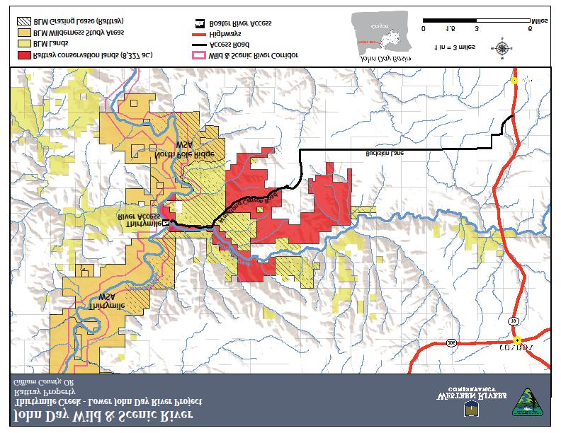
1 1. Project Title: Thirtymile Creek Restoration 2. Applicant: Western Rivers Conservancy ACCESS & HABITAT PROGRAM Application for Grant Funds Grantee: Western Rivers Conservancy Address: 71 SW Oak St., Suite 100 City/State/Zip: Portland, OR Contact: Sue Doroff, President Phone: Location: ODFW Region: East Region Watershed District / WM Unit: John Day Watershed /East Biggs WMU County: Gilliam Township/Range/Section: T5S, R19E, part of Sections 4, 5, 8, and 9 4. Type of Project (check): Habitat Improvement Access Damage Other (specify) 5. Number of Acres of Habitat to be Improved: 109 acres 6. Number of Acres of Access to be Provided: 8,327 acres of private land that will also provide new access to more than 78,000 acres of existing BLM lands. Welcome to Hunt: 8,327 acres of current private land, over 78,000 of existing BLM land By Permission: 80 acres 7. Proposed Start Date: June 2017 Proposed End Date: October Estimated Cost of Project: $25, Access and Habitat Fund Request: $16, Briefly explain what the project proposes to do: Western Rivers Conservancy (WRC) requests funding to restore 109 acres of former agricultural lands to native grasslands in the lower John Day River Canyon at Thirtymile Creek. The project will directly improve important habitat for game and non-game species such as big horn sheep, deer and upland birds, while opening prized new access (equestrian, hiking, driving, boating) for hunters to 8,327 acres of the Rattray Ranch, and 78,000 acres of adjacent BLM Wilderness Study Areas that are currently only reachable by boat. In addition to the restoration of these 109 acres, the public benefits from the access afforded to over 80,000 acres of land.
2 11. Background: Describe the project area and explain the wildlife habitat and/or access challenge or opportunity this project will address. Address how current management actions benefit public access and/or wildlife and their habitat needs. The lower John Day River is a recreationist s paradise, with hunting opportunities abounding for upland game birds, mule deer, pronghorn, elk and bighorn sheep. However, access to the lower canyon is sparse, and riparian habitat is degraded in many areas. To address these issues, Western Rivers Conservancy has made a series of acquisitions in the lower John Day Basin including the lands that became Cottonwood Canyon State Park in 2013 (hunting is allowed in CCST, a rarity for a Oregon State Park). Our current focus is the Rattray Ranch at Thirtymile Creek, which encompasses 14,148 acres and a 10,530-acre BLM grazing lease. Thirtymile Creek is regarded as the most important spawning and rearing tributary for steelhead on the lower John Day River, sustaining cold-water flows through the summer. The property s John Day River reach is also essential habitat for spring chinook. WRC bought the Rattray Ranch in 2014 and is in the process of conveying 8,327 acres of the ranch to the Bureau of Land Management for public recreation, including hunting and fishing, and to greatly enhance fish and wildlife habitat. The lands to be conveyed to the BLM lie along the east side of John Day River up and downstream from the mouth of Thirtymile Creek, up the Thirtymile Creek drainage, and up Armstrong Canyon, a tributary of Thirtymile Creek. WRC is specifically requesting funding to restore 109 acres of abandoned cropland on the Rattray Ranch to its native condition, thereby improving habitat for game and non-game species such as big horn sheep, deer and upland birds. These 109 acres are primarily surrounded by sagebrush steppe habitat- a Strategy Habitat as identified in the Oregon Conservation Strategy. The Rattray Ranch will deliver the only public access on a 74-mile stretch of river between Condon and Cottonwood Bridges, and will provide access to a much larger block of BLM Wilderness Study Areas. Conveying the property to the BLM will forever secure the public the opportunity to hunt, fish, hike and boat this sublime wilderness stretch of the John Day Canyon. 12. Past A&H History: (Describe any past Access & Habitat project, especially if the proposed project deals with the same objectives.) Western Rivers Conservancy received A&H funding for a restoration project in Cottonwood Canyon State Park in The objectives were very similar to this proposal the lands had been impacted by nearly a century of agricultural use and the project enabled their restoration to a natural condition more beneficial to wildlife. WRC allowed the public to hunt and fish on the property while WRC owned it. We also worked successfully to ensure the public could continue to hunt CCSP under the Oregon Parks and Recreation District s ownership. Oregon State Parks typically do not allow for hunting, and we consider continued public hunting at CCSP to be a significant accomplishment. 13. Project Objective(s): What is the objective of the proposed project? Acquisition and restoration of the Rattray Ranch will achieve the following objectives: Restoration of 109 acres of former croplands to native grasslands to benefit game birds, elk, mule deer, pronghorn and bighorn sheep and other species; Improvement of currently degraded steelhead habitat along four miles of Thirtymile Creek, ensuring the stream remains a critical source of cold water for the John Day during summer drought; Conservation of the ranch s 12 miles of river frontage along the John Day River itself; and Conveyance of 8,327 acres into BLM hands to ensure permanent public recreational access.
3 How will the project benefit wildlife habitat? The Rattray Ranch lies at the heart of the John Day s best habitat for California bighorn sheep, supporting an estimated 600 to 650 head, the largest herd in Oregon. Bighorn sheep are highly vulnerable to disease and can experience steep population declines as a result, making habitat conservation all the more important. The area is also home to 40 mammal species including Rocky Mountain elk, mule deer, pronghorn and mountain lion, as well as upland game birds and 150 bird species including sensitive species such as grasshopper sparrow, loggerhead shrike, burrowing owl and ferruginous hawk. Conserving high-quality feeding and nesting habitat for these animals is key to their long-term vitality, and the restoration abandoned croplands to native grasslands will enhance this habitat. Select species that will benefit from habitat improvements: Big Game Upland Bird Migratory Game Bird Deer Chukar Ducks Elk Mountain Quail Geese Bear Valley Quail American Coot Cougar Pheasants Wilsons Snipe Pronghorn Forest Grouse Mourning Dove Bighorn Sheep Turkey Band Tailed Pigeon Mountain Goat Gray Partridge Sage Grouse Length of time benefits provided: <3yr 3-6yr >6yr Examples of Project Benefit Duration Noxious weed... 2yrs Forage planting... 5yrs Aspen fencing... 10yrs Range fertilization 2yrs Forest thinning 5yrs Aspen plant/fence.. 10yrs Rx Fire-grassland.. 2yrs Aspen (conifer removal). 5yrs Road closure.. 10yrs Rx Fire-forested 3yrs Juniper removal... 7yrs Road decommission... 10yrs Fence Removal 10yrs Water Dev./Enhancement.. 10yrs (Source: Blue Mountains Elk Initiative Project Evaluation Criteria) How will the project benefit public access? If limited access, how many hunters will be permitted? A tremendous asset for hunters and recreationists, the project will secure 8,327 acres for the public including the only access point on a 74-mile stretch of the Lower John Day River. The Rattray Ranch s strategic location will also open access to an additional 78,000 acres of BLM Wilderness Study Areas that currently can only be reached by boat. Managing new public river access at Thirtymile Creek is essential to create shorter trip alternatives and to manage recreational use compatibly with the Wild and Scenic River designation. The project will also provide much-needed camping sites on riverside flats. Under the management of the BLM, hunting will presumably be on an Open to Hunt basis. Western Rivers Conservancy will retain ownership of 80 acres that will be open for hunting by permission.
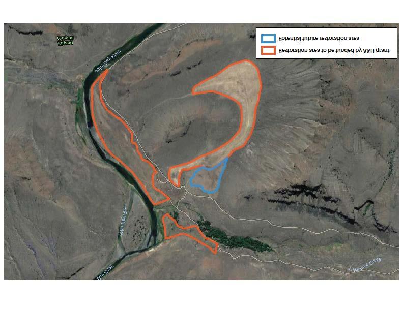
4 Select species for which public access will provided: Big Game Upland Bird Migratory Game Bird Deer Chukar Ducks Elk Mountain Quail Geese Bear Valley Quail American Coot Cougar Pheasants Wilsons Snipe Pronghorn Forest Grouse Mourning Dove Bighorn Sheep Turkey Band Tailed Pigeon Mountain Goat Gray Partridge Sage Grouse Other: Coyote If damage related, how will the project alleviate/eliminate the problem? This project is not damage related. 14. Project Location: (Attach a map and provide description of the location and how to get there from a major highway.) The project is accessible by vehicle by driving south from Condon on Highway 19 to Wehrli Canyon Road, to Buckhorn road, to Armstrong Canyon Road. There is a locked gate at the head of Armstrong Canyon; the key can be obtained from Western Rivers Conservancy. 15. Procedure: Specifically describe how the project will be conducted--use separate page for additional information, drawings, or pictures. The abandoned croplands identified on the attached map (Attachment A) will have three weed treatments spring 2017, fall 2017, early spring 2018 then will be planted with native grasses and forbs. WRC is working with BLM botanists to decide on the optimal seed mixture. Please see Attachment B for detailed Planting Guide information that has been provided by the Contractor completing the work. 16. Permits: Have all of the appropriate permits been secured or applied for? (Examples: Water Resources Department for water rights, Division of State Lands for fill-removal or wetlands projects). None needed. 17. Scheduling: What is the estimated project schedule? Habitat Work Start Date: June 2017 Habitat Work Completion Date: July 2018 Access Agreement Start Date: Access Agreement End Date: Public access will be provided by the BLM sometime after the conveyance in The schedule for this opening has not been established yet.
5 List major project activities and time schedule for each: Activity Time (month/year) Weed control Spring 2017 Weed control Fall 2017 Conveyance of land to BLM Fall 2017 Weed control Spring 2018 Seeding Late spring Participation and Funding: Will other organizations or individuals participate in the project? If so, list and describe participation, and attach letters of commitment or verification of grant awards. Costs listed here must be included in Other Funds column of the Project Budget (Section 20). The BLM will purchase WRC s ownership at Thirtymile Creek using Land and Water Conservation Fund funding in the fall of 2017, ensuring access for the public. For the restoration component of the project, WRC is partnering with ODFW and the BLM to determine the optimal seed mixture for replanting and with the Gilliam County Weedmaster to control noxious weeds. In addition, WRC is partnering with the Gilliam County Soil and Water Conservation District on a complimentary stream restoration project that is designed to improve habitat for native fish in Thirtymile Creek. We have listed these partnerships below but not in Section 20 so as not to add confusion to the costs of the cropland restoration project. Participant Activity Cost 1. Bureau of Land Management Land Acquisition Undetermined 2. Gilliam County Soil and Water Conservation District Stream Restoration Unknown 3. Western Rivers Conservancy Project Administration $1, Oregon Department of Fish & Wildlife Habitat Restoration $7,357 Have any conditions been placed on the funds listed above which may affect the completion of the project? If so, identify and explain. None. 19. Project Maintenance and Monitoring: Who will maintain the project and fund long-term maintenance and/or operation if needed? Bureau of Land Management. What element(s) of the project will be monitored, how often, for how long? BLM will monitor the project pursuant to their guidelines. WRC follows up on its past projects on a fiveyear basis. WRC will retain ownership of 80 acres, which includes 40-acres in the restored land project area. WRC will monitor this area annually to determine how successful the restoration has been.
6 20. Project Budget (provide as much detail as possible) (As stated in Item 18, the cost of the land acquisition component of the overall project have not been included in this budget.) Category A&H Funds Other Funds1 Total Cost Administration Personnel $1500 $1500 $3000 % Total Construction Materials2 Supplies Weed Spray $5683 $2567 $8250 Seed $1090 $1090 Contract Services3 (itemize) Technical Consulting $975 $975 $1950 Weed Spraying $5450 $2725 $8175 Mowing $1635 $1090 $2725 Equipment4 (itemize) Access Payment TOTAL COSTS $16,333 $8,857 $25,190 1 List detail in funding (section 18). 2 Provide amounts and cost per unit. 3 Attach subcontractor estimates. 4 Individual pieces of equipment costing over $
7
8
9 Attachment B Non-Typical Ranch Consulting-Planting Guide General Information INTRODUCTION Costs to plant and produce native grass stands in the John Day River Basin are shown in this crop plan and estimate. The plan is intended as a guide only, and can be used to make planting decisions, and to prepare budgets and estimates. Practices described are based on the production practices considered typical for this plant species and region, but will not apply to every situation. Costs for labor, materials, and equipment and custom services are based on current figures. The hypothetical farm operations, production practices, overhead, and calculations are described under the assumptions ASSUMPTIONS The following assumptions refer to costs associated with planting native grass stands in the John Day River Basin. Practices described represent production practices and materials considered typical of a well-managed acres in the region. The costs, materials, and practices shown in this will not apply to all situations. Establishment and production cultural practices vary by grower and the differences can be significant. The costs associated with ground preparation, planting, and growing native grass stands in the region. Land Preparation. Land preparations begin in the spring (March/April). The fields are mowed once with a rotary mower to incorporate the previous weed/crop residue. After mowing one pass, the field will be sprayed with chemical, to prepare the seedbed for seeding. Planting. In late March to early April, the native grass seed is planted on flat ground in 30 to 38-inch lines at a rate of 10 pounds of seeds per acre. A custom planter does the planting for $25 per acre. Raised beds are formed after planting by cultivating and furrowing. Fertilization. Growers should apply fertilizer or soil amendments after soil tests determine nutrient and ph levels. Nitrogen (N) as anhydrous ammonia (80-0-0) is injected and side dressed once in June at 100 pounds N per acre and water run once in July at 40 pounds N per acre. Pest Management. For more information on other pesticides available, pest identification, monitoring, and management visit the UC IPM website at contact your local UCCE farm advisor. For information and pesticide use permits, contact the local county agricultural commissioner's office. Adjuvants or surfactants may be recommended for use with some pesticides, but are not included in this study. Pesticide costs vary by location and grower volume. Pesticide and fertilizer costs are taken from a single dealer and are shown as full retail. Pest Control Adviser (PCA). Written recommendations are required for many pesticides and are made by licensed pest control advisers. In addition the PCA will monitor the field for agronomic problems including pests and nutrition. Growers may hire private PCAs or receive the service as part of a service agreement with an agricultural chemical and fertilizer company. Weeds. Post plant weed control consists of mechanical and chemical practices. Shortly after planting, an herbicide (Milestone) is applied for broadleaf control. A layby application of Prowl is applied in June. Normally, seven to eight days after the post-emergent herbicide application, the field is cultivated and furrowed and again approximately two weeks after the first irrigation. Labor, Equipment and Interest Costs Labor. Labor rates of $15.00 per hour for machine operators and $12.00 for general labor includes payroll overhead of 36%. The basic hourly wages are $15.00 for machine operators and $12.00 for general labor. The overhead includes the employers share of federal and Oregon state payroll taxes, workers' compensation insurance for field crops (code 0071), and a percentage for other possible benefits. Workers compensation costs will vary among growers.
10 Labor for operations involving machinery are 20% higher than the operation time given for the extra labor involved in equipment set up, moving, maintenance, work breaks, and field repair. Equipment Operating Costs. Repair costs are based on purchase price, annual hours of use, total hours of life, and repair coefficients formulated by the American Society of Agricultural Engineers (ASAE). Fuel and lubrication costs are also determined by ASAE equations based on maximum power take off (PTO) horsepower and fuel type. Prices for on-farm delivery of diesel and gasoline are $3.70 (excludes excise taxes) and $3.36 per gallon, respectively. The fuel prices are the average costs from July through December 2008 derived from American Automobile Association (AAA) and Energy Information Administration monthly data. The cost includes a 2.25% sales tax for diesel fuel, and federal and excise taxes plus an 8% sales tax on gasoline. The federal and state excise tax on gasoline used on the farm can be refunded for on-farm use when filing your income tax. The fuel, lube, and repair cost per acre for each operation in the Cost Per Acre to Produce table is determined by multiplying the total hourly operating cost in the Hourly Equipment Costs table for each piece of equipment used from the Operation Time (Hrs/A) column by the hours per acre. Tractor time is 10% higher than implement time for a given operation to account for setup, travel and down time. Cash overhead consists of various cash expenses paid out during the year that are assigned to the farm and not to a particular operation. Property Taxes. Counties charge a base property tax at the rate of 1% on the assessed value of the property including land, equipment, buildings, and improvements. In some counties special assessment districts exist and charge additional taxes on property. For this study, county taxes are calculated as 1% of the average value of the property. Average value equals new cost plus salvage value divided by 2 on a per acre basis. Land value is assumed to remain unchanged. Insurance. Insurance for farm investments varies depending on the assets included and the amount of coverage. Property insurance provides coverage for property loss and is charged at 0.82% of the average value of the assets over their useful life. Liability insurance covers accidents on the farm and costs $983 for the entire farm or $3.51 per producing acre. Office Expense. Office and business expenses are estimated at $65 per producing acre. These expenses include office supplies, telephones, bookkeeping, accounting, legal fees, and miscellaneous overhead expenses Land. Land values for row crop land in the region range from $3,500 per acre to $12,000 per acre. Prices are affected by location, soil type, and water availability. In this study the silage is grown on rented land (see Land Rent). Irrigation System. An irrigation district supplies water, though growers may supplement this with well water in some areas. The amount of water used to irrigate sorghum will vary in the San Joaquin Valley. District and well water costs were combined to obtain an average cost for water. The permanent irrigation system consists of buried mainline. This part of the system is already in place when the land is purchased/rented; therefore, no costs are shown. Equipment. Farm equipment is purchased new or used, but the study shows the current purchase price for new equipment. The new purchase price is adjusted to 60% to indicate a mix of new and used equipment. Annual ownership costs for equipment and other investments are shown in the Whole Farm Annual Equipment, Investment, and Business Overhead Costs table. Equipment costs are composed of three parts: non-cash overhead, cash overhead, and operating costs. Both of the overhead factors have been discussed in previous sections. The operating costs consist of repairs, fuel, and lubrication and are discussed under operating costs.
11 Non-Typical Ranch Consulting LLC. Estimate 101 SE 3rd Number: 25 Pendleton, OR Date: 11/22/2016 PH Bill To: Ship To: Western Rivers Conservancy Western Rivers Conservancy 71 SW Oak St., # SW Oak St., # 100 Portland, OR Portland, OR Attn: Josh Kling Attn: Josh Kling Description Rate Total Hours Amount Acres Spring 2017 Estimate of spraying 109 acres, Rattray Ranch, John Day River $ $ 2, Spring 2017 Fall 2017 Fall 2017 Estimate of Chemial provied for Pest Management Estimate of field mowing Estimate of spraying 109 acres, Rattray Ranch, John Day River Estimate of Chemial provied for Pest Management Seed Cost Estimate Estimate of Seeding $ 2, $ 2, $ $ 1, $ $ 2, $ 2, $ 2, $ $ 1, $ $ 2, $ $ $ $ - Sub. Total $ 15, Reimbursements Scott Coe hours $ $1, NOTES - Estimates are based on current costs Total $1, Total $ - Thank You, Scott Coe Total $17,805.00
12
 676-5230 FAX (541) 676-9075 www.dfw.state.or.")

13 Oregon Kate Brown., Governor Department of Fish and Wildlife Heppner District Office Highway 74 PO Box 363 Heppner, OR Voice (541) FAX (541) June 9, 2017 Access & Habitat Board Oregon Department of Fish & Wildlife 4034 Fairview Industrial Drive SE Salem, Oregon Dear A&H Board Members: This letter is in regards to the Thirtymile creek Restoration proposal. I have been working with Western Rivers Conservancy with their purchases of land and restoration efforts since 2008 when they purchased the privately owned Murtha Ranch which is now Cottonwood Canyon State Park. This project which is similar to one ODFW completed on the abandoned farm fields on the Murtha Ranch will greatly improve the wildlife habitat values in the area and improve public hunter satisfaction. All of the benefits of improving these fields for wildlife will be fully utilized by the public hunter since this land will be conveyed to the Bureau of Land Management. I believe that this is a very worthwhile project and will have positive impacts on upland birds, deer, elk, bighorn sheep as well as many other non-game species. Please feel free to contact me if you have any questions or concerns on this proposal or on the comments in my letter. Respectfully, Steve Cherry District Wildlife Biologist


14 Form Revised July 2012 Access and Habitat Program Project Evaluation Form Program Objective: The Access and Habitat Program s motto, Landowners & Hunters Together for Wildlife, conveys the program s basic mission to foster partnerships between landowners and hunters for the benefit of the wildlife they value. The program also seeks to recognize and encourage the important contributions made by landowners to the state s wildlife resource. Project Name: Thirtymile Creek Restoration Project #: Access Acres "Welcome" Private 8,327 By-Permission Private 80 Inaccessible Public* 0 Accessible Public* 78,000 Habitat Acres Habitat Category: 4 Total Score: 24 (range: 1-6; see flow chart on page 4. Not applicable to access-only projects) Total Possible: 36 Instructions: Complete these sections General Access Project Type Criteria Criteria Habitat Criteria Access Only X X Habitat Only X X Access & Habitat X X X Mark 1 point in the corresponding "Project Score" box for EACH criterion that is met. Example: for question 2, if partnerships include 4 sports groups, award points for the first 2 criteria. Do not mark more than 1 point per box. Point schedule is designed to weigh access-only and habitat-only projects equally. Definitions: Inaccessible Public*: Accessible Public*: Access will be provided through private land to public land that is completely landlocked (surrounded) by private land, legally precluding public hunting access. Total area includes only public land within the boundary of private ownership. Access through private land will improve accessibility to public land. Public land may be extremely difficult to access otherwise, but is not legally surrounded by private land. Total area includes only public land that is closer (in linear distance) to the landowner's access point(s) than any other public access point. * Access to public land MUST be provided on a "Welcome to Hunt" basis General Criteria 1. Habitat Condition (mark a "1" in the "Project Score" box for EACH criterion that is met) Score 1 point only if the property contains the resource in sufficient abundance/quality to support target species referenced in questions 11, 15, 16 and 19 (during at least one season of the year). For habitat projects, use the predicted future condition. Justify your score. Access Fee Assessment Food: Transitioning former agricultural fields to native grasslands 1 1 n/a 1 Water: John Day River and its many tributaries runs through or adjacent to property 1 1 n/a 1 Cover: Shrub steppe habitat 1 1 n/a 1 Project Score Private Land Inacc. Public Acc. Public 2. Partnerships Partners contributing financial or in-kind support: 1 or more Sports groups. 0 3 or more Sports groups. 0 Educational programs / non-governmental organizations. 0 Other government agencies or ODFW programs (i.e. OWEB, R&E). 1 1 n/a 1 Page 1
15 Form Revised July 2012 Project 3. Matching Funds Total matching funds (monetary and in-kind) > 1% matching funds.. Score 1 > 25% matching funds 1 > 50% matching funds 0 4. Damage Project would mitigate current damage to private property: Wildlife damage occuring on private property. 0 Landowner participates in ODFW damage control programs.. 0 Access Fee Assessment 1 n/a 1 General Total General Possible Access Criteria - Applies to private land access that would be provided under the proposed project. (mark a "1" in the "Project Score" box for EACH criterion that is met) 5. Public Land Project located in Wildlife Management Unit with <50% public land n/a 1 6. Private access Private land access type: Project would provide access to private land.. 1 Private land access would be on a "Welcome to Hunt" basis Public access Access through private lands would: improve access to public land provide access to otherwise inaccessible public land Special Access Project would provide special youth or disabled hunter access opportunities. 0 0 n/a 0 9. Species Permitted Species groups include big game, waterfowl, upland birds, turkey, and predators/varmints. 2+ species groups available and permitted. 1 1 n/a 1 4+ species groups available and permitted. 0 0 n/a 0 10.Under-rep. Species* Project provides access to under-represented species in the watershed. 1 1 n/a 1 11.Harvest Restriction Landowner would not restrict sex or species permitted for lawful harvest 1 1 n/a 1 12.Season Restriction Landowner would not restrict access to any hunting season(s) n/a 1 13.Dispersion Property would provide access to animals pushed off of publicly accessible land during hunting season n/a Access Total Access Possible Payment Fee Total 11 n/a 10 * lists of under-represented species will be created by A&H state coordinator and approved by A&H Board Page 2
16 Form Revised July 2012 Habitat Criteria 14.Department Priorities (mark a "1" in the "Project Score" box for EACH criterion that is met) Project Score Project is located within target area and will benefit target species identified in any of these Department programs: Mule Deer Initiative, Sage Grouse Initiative, Black-tailed Deer Plan Implementation Location importance: Applies to species that the habitat work will benefit. Question structured to equally weigh big game and game bird projects - score "1" if either item in each bracket is true: Area populations < 90% of management objective (deer and elk) or: { Project will increase wintering populations of upland birds/waterfowl 1 { Area populations < 75% of management objective (deer and elk). or: Project will increase breeding populations of upland birds/waterfowl 1 16.Conservation Strategy Project addresses Oregon Conservation Strategy (OCS) concerns: Project action benefits Strategy Habitat or Strategy Species. 1 [above] AND action occurs in Conservation Opportunity Area (COA) 1 17.Critical Habitat Applies to the specific GAME habitat that the project will maintain or enhance. Use accompanying flow chart and definitions to determine habitat category. Definitions are slightly amended from OAR Division 415 to be game-specific. Project meets requirements of Habitat Categories Project meets requirements of Habitat Categories Habitat Connectivity Project will help facilitate local animal movement (fence removal, etc.).. 0 Project will help establish or maintain a wildlife habitat corridor or otherwise reduce fragmentation on landscape level.. 0 Description of habitat connectivity benefit (required): 19.Habitat Impact Describes the predicted impact that the project will have on the habitat. Habitat work must benefit game species. Project will increase the habitat quantity/quality >25% per unit treated 1 Project will increase the habitat quantity/quality >50% per unit treated 1 Description of habitat impact: Restoration of 109 acres of former agricultural lands to native grasslands in the lower John Day River Canyon. 20.Population Impact Describes the predicted impact that habitat improvements (excluding external variables such as weather, etc.) will have on game species on the project site. Provide estimates for all targeted species. Local abundance of at least one targeted game species should increase >25%... 1 Estimated Abundance Pretreatmentreatment Post- Species Habitat Total 8 Mule Deer Habitat Possible 12 Upland Bird Grand Total 24 Total Possible Miscellaneous Describe other project details that may help with prioritization or fee assessment (i.e. current market value of similar hunting leases in the vicinity).... NO POINTS Population Impact- Improvements to nesting/rearing habitat for Upland Game Birds will be improved by converting acreage to permanent perennial grassland(s). Improved forage conditions for big game will be enhanced through the incorporation of perennial grasses. Page 3
17 Form Revised July 2012 Access and Habitat Project Evaluation - Appendix Under-represented Species Definition: game species that exist in the watershed district in huntable numbers, but that the general public does not have reasonable hunting access to (via public land, current A&H properties, etc.) Watershed Species Watershed Species Malheur pheasant, waterfowl, turkey Deschutes waterfowl, valley quail, chukar, dove South Willamette waterfowl, turkey, valley quail John Day upland game birds North Coast predators, waterfowl Umpqua waterfowl, dove, turkey Grande Ronde upland game birds Klamath waterfowl, quail Rogue dove, waterfowl North Willamette waterfowl A&H Habitat Category Flow Chart Note: These definitions have been amended from OAR Division 415 to be game-specific and applied on a watershed basis. Habitat Category designations made on this Evaluation Form are for Access & Habitat Program use only, and do not have any legal implications associated with OAR 415. Page 4
18 Thirtymile Creek Restoration Payment Tables Table 1: Proposed Per-acre Access Payment Private Welcome to Hunt ($/acre) Private By- Permission ($/acre) Inaccessible public land ($/acre) Accessible public land ($/acre) Total Score: 100% 60% 40% 20% 1-3: $0.60 $0.36 $0.24 $ : $1.20 $0.72 $0.48 $ : $1.80 $1.08 $0.72 $ : $2.40 $1.44 $0.96 $ : $3.00 $1.80 $1.20 $0.60 Table 2: Proposed Total Access Payment Calculator Access Type Score $/Acre Acres Payment Private Welcome 11 $2.40 8,327 $19, Private Permission 11 $ $ Inaccessible Public n/a n/a 0 n/a Accessible Public 10 $ ,000 $37, Total Payment: $57,540.00
: Western Rivers Conservancy Date of Council Review: June 13, 2017 Type of Project: Access Habitat X Other Damage Motion: Morgan Olson made a motion to approve the project as")
19 ACCESS & HABITAT PROGRAM Regional Advisory Council Project Proposal Review ODFW Region / A&H Regional Council: East Region / Northeast Council Project Proposal Title: Thirtymile Creek Restoration Applicants(s): Western Rivers Conservancy Date of Council Review: June 13, 2017 Type of Project: Access Habitat X Other Damage Motion: Morgan Olson made a motion to approve the project as proposed. John Groupe seconded the motion. Council Member Position Vote Morgan Olson Chairman Yes Vicki McClaran Landowner Representative Yes Joseph Patnode Landowner Representative Absent Larry Snyder Landowner Representative Yes Tim Campbell Hunter Representative Yes Vacant Hunter Representative Absent John Groupe Hunter Representative Yes Disposition of Vote: Motion passed 5:0 Project Strengths: This project area is a high priority for the Heppner Wildlife District as it provides access to a substantial portion of difficult to access BLM lands in a Wildlife Management Unit that is heavily skewed towards private ownership- 11% public lands. The project will improve access to 78,000 acres of difficult to access BLM lands ultimately benefitting all forms of recreation. Access to these public lands has been sparse, with the only real avenue for access to the lower John Day River canyon being by boat. This project will assist in the effort to provide additional access points to this highly desired location. The project will restore 109 acres of former agricultural lands to native grasslands converting them to year-round wildlife habitat benefitting upland game birds and big game alike. The wide variety of wildlife that will benefit from this project, coupled with the recreational values of the area, make this project a highly desirable asset to the A&H Program and its many users. Project Concerns: None
ACCESS & HABITAT PROGRAM Regional Advisory Council Project Proposal Review
 ACCESS & HABITAT PROGRAM Regional Advisory Council Project Proposal Review ODFW Region / A&H Regional Council: East Region / Northeast Council Project Proposal Title: Heppner Regulated Hunt Area 2016-09
ACCESS & HABITAT PROGRAM Regional Advisory Council Project Proposal Review
 ACCESS & HABITAT PROGRAM Regional Advisory Council Project Proposal Review ODFW Region / A&H Regional Council: East Region / Malheur Council Project Proposal Title: Brown Access Project Applicants(s):
ACCESS & HABITAT PROGRAM Regional Advisory Council Project Proposal Review
 ACCESS & HABITAT PROGRAM Regional Advisory Council Project Proposal Review ODFW Region / A&H Regional Council: East Region / Malheur Council Project Proposal Title: Mackenzie Access Project Applicants(s):
ACCESS & HABITAT PROGRAM Regional Advisory Council Project Proposal Review
 Page 1 of 20 Page 2 of 20 ACCESS & HABITAT PROGRAM Regional Advisory Council Project Proposal Review ODFW Region / A&H Regional Council: East Region / Northeast Council Project Proposal Title: Murderers
ACCESS & HABITAT PROGRAM Regional Advisory Council Project Proposal Review
 ACCESS & HABITAT PROGRAM Regional Advisory Council Project Proposal Review ODFW Region / A&H Regional Council: East Region / Northeast Council Project Proposal Title: Columbia Plateau Cooperative Habitat
ACCESS & HABITAT PROGRAM Regional Advisory Council Project Proposal Review
 ACCESS & HABITAT PROGRAM Regional Advisory Council Project Proposal Review ODFW Region / A&H Regional Council: Southwest Project Proposal Title: New River Aleutian Goose Project Applicants(s): Mike Knapp,
ACCESS & HABITAT PROGRAM Regional Advisory Council Project Proposal Review
 ACCESS & HABITAT PROGRAM Regional Advisory Council Project Proposal Review ODFW Region / A&H Regional Council: West Region / South Willamette Council Project Proposal Title: Wendling Travel Management
ACCESS & HABITAT PROGRAM Regional Advisory Council Project Proposal Review
 ACCESS & HABITAT PROGRAM Regional Advisory Council Project Proposal Review ODFW Region / A&H Regional Council: West Region / South Willamette Council Project Proposal Title: Willamette Private Lands Law
OREGON DEPARTMENT OF FISH AND WILDLIFE
 OREGON DEPARTMENT OF FISH AND WILDLIFE Ladd Marsh Wildlife Area 1 Benefits for all Oregonians 2 The Mission To protect and enhance Oregon's fish and wildlife and their habitats for use and enjoyment by
ACCESS & HABITAT PROGRAM Regional Advisory Council Project Proposal Review
 ACCESS & HABITAT PROGRAM Regional Advisory Council Project Proposal Review ODFW Region / A&H Regional Council: Northeast Region / Northeast Council Project Proposal Title: Green Diamond Resource Company
ACCESS & HABITAT PROGRAM Regional Advisory Council Project Proposal Review
 ACCESS & HABITAT PROGRAM Regional Advisory Council Project Proposal Review ODFW Region / A&H Regional Council: East Region / Malheur Watershed Council Project Proposal Title: Alvord Access Area Applicants(s):
2014 Oregon Hunting Survey: An effort to better understand the choices Oregon hunters make regarding ammunition
 2014 Oregon Hunting Survey: An effort to better understand the choices Oregon hunters make regarding ammunition Q1. How many years have you lived in Oregon? YEARS LIVED IN OREGON Q2. How many years have
 Exhibit E Oregon Department of Fish & Wildlife Access & Habitat Program Access & Habitat Project Completion Report Project Number: 2012-11 Project Title: Zumwalt Prairie Elk Hazing and Habitat Protection
Hunting, Fishing, Recreational Shooting, and Wildlife Conservation Opportunities and Coordination with States, Tribes, and Territories
 THE SECRETARY OF THE INTERIOR WASHINGTON ORDER NO. 3356 Subject: Hunting, Fishing, Recreational Shooting, and Wildlife Conservation Opportunities and Coordination with States, Tribes, and Territories Sec.
ARkAnsAs tennessee Primary Partner: Primary Partner: Habitat Work: Habitat Work:
 Eastern Elk initiative david STEPhENSON Elk in the East On foggy mornings when the chill of fall is in the air, distant elk bugles ring sparsely through the hills and valleys of the East. Each one tells
placed on the market.
 With Mimbres River frontage and tremendous grass forage, this jewel in New Mexico s Southern Gila Region is a must have for the discriminating buyer looking to have it all in one easily operated grazing
Results from the 2012 Quail Action Plan Landowner Survey
 Results from the 2012 Quail Action Plan Landowner Survey By Andrew W Burnett New Jersey DEP Division of Fish & Wildlife Mail Code 501 03 PO Box 420 Trenton 08625 0420 Abstract: A survey was conducted in
Proposed Upland Game Bird Regulations
 Fish and Wildlife Commission Meeting April 20, 2018, Astoria Kelly Walton Asst. Game Bird Biologist 2018-19 Proposed Upland Game Bird Regulations Exhibit B 1 Upland Game Bird Regulations Brief Overview:
PRISTINE. PRIVATE. PERFECT.
 PRISTINE. PRIVATE. PERFECT. A sublime parcel of the American West, Inyanga Ranch consists of over 530 acres of beautiful river frontage, ponds, meadows and historic cabins at the end of a box canyon, protected
Annual Report for Fiscal Year and Future Plans for the Tillamook Bay Watershed Council
 Annual Report for Fiscal Year 2012-2013 and Future Plans for the Tillamook Bay Watershed Council A report prepared for the Tillamook County Board of Commissioners August 2013 Table of Contents: Recently
Confederated Tribes of the Umatilla Indian Reservation -- Cayuse, Umatilla, and Walla Walla Tribes
 2018-2019 Treaty Hunting Seasons and Regulations Confederated Tribes of the Umatilla Indian Reservation -- Cayuse, Umatilla, and Walla Walla Tribes CTUIR Tribal Hunting Rights Reserved in 1855 Treaty a
Ely, Nevada Highway Commercial Office/Warehouse/Industrial Property
 Ely, Nevada Highway Commercial Office/Warehouse/Industrial Property 6,000 + SF Office/Warehouse has 2 half baths, office, and roll up doors on the east and west walls 5.81 acre parcel fronts Highway 93
Access and Habitat Board Meeting Minutes Mon/Tue, April 10-11, :00 a.m. Inn at Face Rock 3225 Beachloop Road Bandon, Oregon 97411
 1 1 1 1 1 1 1 1 0 1 0 1 Access and Habitat Board Meeting Minutes Mon/Tue, April -, 01 :00 a.m. Inn at Face Rock Beachloop Road Bandon, Oregon Access and Habitat Board meeting minutes are considered draft
ECONOMIC VALUE OF OUTFITTED TRIPS TO CONSERVATION ORGANIZATIONS
 ECONOMIC VALUE OF OUTFITTED TRIPS TO CONSERVATION ORGANIZATIONS An Eight-State Pilot Study Report Produced by Professional Outfitters and Guides of America Edited by Mac Minard, Executive Director, Montana
The Lake Creek Ranch. Located in the foothills of the Owl Creek Mountains in western Hot Springs County, Wyoming
 The Lake Creek Ranch Located in the foothills of the Owl Creek Mountains in western Hot Springs County, Wyoming Experienced Professional Ranch Brokers Specializing in the sale of ranches, farms, & recreational
CHECKS AND BALANCES. OVERVIEW Students become managers of a herd of animals in a paper-pencil, discussionbased
 CHECKS AND BALANCES 5 OVERVIEW Students become managers of a herd of animals in a paper-pencil, discussionbased activity. BACKGROUND White Tailed Deer White-tailed deer have always been a part of the forest
Mule Deer. Dennis D. Austin. Published by Utah State University Press. For additional information about this book
 Mule Deer Dennis D. Austin Published by Utah State University Press Austin, D.. Mule Deer: A Handbook for Utah Hunters and Landowners. Logan: Utah State University Press, 2010. Project MUSE., https://muse.jhu.edu/.
O Bar O Ranch Graham County, Arizona
 O Bar O Ranch Graham County, Arizona Offered for sale exclusively by: Walter Lane Headquarters West, Ltd. 4582 N 1 st Avenue Tucson, AZ 85718 Telephone (520) 792-2652; Fax (520) 792-2629 www.headquarterswest.com
The Berggren Plan Nebraska s Plan to Improve Pheasant Hunting. John Laux, NGPC RWBJV Informational Seminar February 2, 2017
 The Berggren Plan Nebraska s Plan to Improve Pheasant Hunting John Laux, NGPC RWBJV Informational Seminar February 2, 2017 Long-Term Pheasant Decline in Nebraska Changes in Agricultural Land-Use *Source:
White Horse Canyon Ranch
 White Horse Canyon Ranch Modoc County, California Proudly Offered By 707 Merchant Street, Suite 100, Vacaville, Ca 95688 (707) 455-4444 Office (707) 455-0455 Fax info@caoutdoorproperties.com Introduction
COLORADO DIVISION OF WILDLIFE WILDLIFE DEVELOPMENT STANDARDS & GUIDELINES SOUTHEAST REGIONAL SERVICE CENTER, COLORADO
 COLORADO DIVISION OF WILDLIFE WILDLIFE DEVELOPMENT STANDARDS & GUIDELINES SOUTHEAST REGIONAL SERVICE CENTER, COLORADO The Colorado Division of Wildlife, Southeast Region has developed the following general
JF2 RANCH ACRES FRIO COUNTY, PEARSALL, TX REPUBLICRANCHES.COM MURPHY E. RAY. Sales Agent
 JF2 RANCH 668 + ACRES FRIO COUNTY, PEARSALL, TX MURPHY E. RAY Sales Agent 210-415-8510 murphy@republicranches.com REPUBLICRANCHES.COM JF2 RANCH The JF2 Ranch is an exceptional high fenced recreational
FWCP External Projects Delivered by Stakeholders and First Nations
 FWCP External Projects Delivered by Stakeholders and First Nations 2013-2014 For more information contact FWCP-Columbia program manager, Trevor Oussoren Trevor.oussoren@bchydro.com 250-365-4551 2013-2014
Wildlife Introduction
 Wildlife Introduction The wildlife section of this chapter is divided into sections for various habitats and groups of species. Old growth, snags and downed wood, and riparian areas are unique habitats
WILDLIFE HERITAGE TRUST ACCOUNT PROJECT PROPOSAL FORM
 APPLICANT INFORMATION WILDLIFE HERITAGE TRUST ACCOUNT PROJECT PROPOSAL FORM Person/Organization/Agency Nevada Department Of Wildlife (NDOW) Name Mike Cox Title Big Game Staff Biologist Address 1 4600 Kietzke
contents 2004 Big Game Statistics
 2004 Big Game Statistics Introduction How to use this information... 2 Setting regulations... 3 How the information is collected... 4 How the management system works... 5 Making your points work for you...
contents 2009 Big Game Statistics
 2009 Big Game Statistics Introduction How to use this information... 2 Setting regulations... 3 How the information is collected... 4 How the management system works... 5 Making your points work for you...
Utah. North Stansbury Mountains Wilderness Study Area Site-Specific Monitoring Guide
 Utah North Stansbury Mountains Wilderness Study Area Site-Specific Monitoring Guide 1 General Information WildSNAP Monitoring Peter Woodruff, American Conservation Experience Coordinator Phone (801) 989-7069
ALBERTA FISH & GAME ASSOCIATION 2015 ANNUAL GENERAL MEETING PASSED RESOLUTIONS FEBRUARY 21, 2015
 ALBERTA FISH & GAME ASSOCIATION 2015 ANNUAL GENERAL MEETING PASSED RESOLUTIONS FEBRUARY 21, 2015 GENERAL RESOLUTION NUMBER G-1-2015 and Sustainable Resource Development permit the use of crossbows during
JC Mesa Ranch. Colorado - San Miguel County - Telluride
 Commanding stunning views of Telluride and surrounding peaks, the 2,379 deeded-acre JC Mesa Ranch is one of the only remaining undeveloped and unencumbered ranches in the Telluride area. Surrounded by
Subject to sale, withdrawal, or error.
 We are privileged to have the exclusive listing on a very scenic ranch in the beautiful western foothills of the Jemez Mountains in the northwest central area of New Mexico. This outstanding offering is
TRCP National Sportsmen s Survey Online/phone survey of 1,000 hunters and anglers throughout the United States
 #17144 TRCP National Sportsmen s Survey Online/phone survey of 1,000 hunters and anglers throughout the United States Methodology Public Opinion Strategies conducted a national survey of N =1,000 voters
Crook Ranch. Tehama County, California. Proudly Offered By
 Crook Ranch Tehama County, California Proudly Offered By 707 Merchant Street, Suite 100, Vacaville, Ca 95688 (707) 455-4444 Office (707) 455-0455 Fax info@caoutdoorproperties.com www.californiaoutdoorproperties.com
SELBY RANCH CALIFORNIA, YUBA COUNTY, BROWNS VALLEY. Recreational Haven in Northern California with Excellent Fishing and Hunting
 SELBY RANCH CALIFORNIA, YUBA COUNTY, BROWNS VALLEY Recreational Haven in Northern California with Excellent Fishing and Hunting This beautiful 1,812-acre ranch is located in the Gold Country Foothills
A Comparison of Western Watershed Councils. Presentation Prepared by Jeff Salt, Great Salt Lakekeeper
 A Comparison of Western Watershed Councils Presentation Prepared by Jeff Salt, Great Salt Lakekeeper Presentation Overview Introduction Jordan River Watershed Council Lower Boise Watershed Council Clackamas
Proposed Upland Game Bird Regulations
 2017-18 Proposed Upland Game Bird Regulations Fish and Wildlife Commission Meeting April 21, 2017, Klamath Falls, Oregon Dave Budeau Upland Game Bird Coordinator Upland Game Bird Regulations Brief Overview:
The University of Georgia
 The University of Georgia Center for Agribusiness and Economic Development College of Agricultural and Environmental Sciences Economic Impacts of Alabama Quail Hunting Prepared by: Archie Flanders and
REVIEW OF USDA FOREST SERVICE COMMUNITY-BASED WATERSHED RESTORATION PARTNERSHIPS APPENDIX J
 REVIEW OF USDA FOREST SERVICE COMMUNITY-BASED WATERSHED RESTORATION PARTNERSHIPS APPENDIX J Reviews of Watershed Projects Bob Doppelt and Craig Shinn, Portland State University DeWitt John, Bowdoin College
Subject to sale, withdrawal, or error.
 We are proud to offer for sale this long-term family ownership ranch located in northwestern Cottle County. The property is located northwest of Paducah in the central Rolling Plains and adjoins the 28,000
PROTECTING SAGE GROUSE AND THEIR HABITAT IN THE WEST. John Harja Senior Counsel on Detail to the Public Lands Office
 PROTECTING SAGE GROUSE AND THEIR HABITAT IN THE WEST John Harja Senior Counsel on Detail to the Public Lands Office Chick Female (Hen) Male (Cock) Nest w eggs Lek Sage-grouse need sagebrush. Landscape-scale
FLATHEAD INDIAN RESERVATION
 FLATHEAD INDIAN RESERVATION PHEASANTS, GRAY PARTRIDGE AND MIGRATORY WATERFOWL 2017-18 HUNTING SEASONS, SHOOTING HOURS AND LIMITS Upland Game Birds Gray Partridge Hunting Season: September 1, 2017 through
FOR SALE Sprague River Ranch
 FOR SALE Sprague River Ranch Klamath County, OR 30,620 ± Total acres 15,620 Deeded acres 15,000 Leased acres $23,350,000 The Sprague River Ranch is the quintessential combination of a recreational and
Southwest Regional Advisory Council. Council Appointments October Table of Contents. Duran, Christopher Hunter N/A 3. Haley, Jason Hunter N/A 9
 Southwest Regional Advisory Council Council Appointments October 2014 Table of Contents Name Position Council Recommendation Page Number Duran, Christopher Hunter N/A 3 Fields, James Hunter Appoint as
Wind Rock Ranch DUBOIS, WYOMING
 Wind Rock Ranch DUBOIS, WYOMING Wind Rock Ranch DUBOIS, WYOMING Introduction: The Wind Rock Ranch is located in Fremont County, Wyoming, six miles south-east of the town of Dubois, WY. The ranch headquarters
Management History of the Edwards Plateau
 Management History of the Edwards Plateau Eco regions of Texas Edwards Plateau 24,000,000 acres About 15,000 years ago, the Edwards Plateau was much cooler and was more forested than today. Pollen counts
LONG CREEK, OREGON APPROXIMATELY 1,313 TOTAL DEEDED ACRES
 LONG CREEK, OREGON APPROXIMATELY 1,313 TOTAL DEEDED ACRES OVER 1 MILE LONG CREEK THRU PROPERTY OVER 4/5 MILE MALHEUR NATIONAL FOREST FRONTAGE 3 ea. LANDOWNER HUNTING TAGS DEER & ELK SEASONAL SUMMER GRAZING
2016 Auction Tag Sponsorship Applicants
 2016 Auction Tag Sponsorship Applicants Organization Chapter p.# Choice 1 Choice 2 Choice 3 Foundation for North American Wild Sheep Oregon 1 Combo Deer 2016 Tag Request Event Date Elk 4/16 Previous 3
The Heber-Reno Domestic Sheep Driveway and Management of Bighorn Sheep in Arizona.
 The Heber-Reno Domestic Sheep Driveway and Management of Bighorn Sheep in Arizona. The driveway occurs on 60 miles of the Apache Sitgreaves National Forest and 80 miles of the Tonto National Forest. The
Frequently Asked Questions About Revised Critical Habitat and Economic Analysis for the Endangered Arroyo Toad
 Q Frequently Asked Questions About Revised Critical Habitat and Economic Analysis for the Endangered Arroyo Toad Q. What is the arroyo toad? The arroyo toad (Bufo californicus) is a small, light greenish-grey
EXECUTIVE SUMMARY Feasibility Study on the Reintroduction of Gray Wolves to the Olympic Peninsula
 EXECUTIVE SUMMARY Feasibility Study on the Reintroduction of Gray Wolves to the Olympic Peninsula Prepared by U.S. Fish and Wildlife Service Western Washington Office Introduction Historical records indicate
May 22, Rayburn House Office Building 2207 Rayburn House Office Building Washington, D.C Washington, D.C
 May 22, 2009 The Honorable James L. Oberstar The Honorable John L. Mica Chairman Ranking Minority Member Committee on Transportation & Infrastructure Committee on Transportation & Infrastructure 2165 Rayburn
Schoolhouse Spring Ranch in Steptoe Valley North of Ely, NV
 Schoolhouse Spring Ranch in Steptoe Valley North of Ely, NV Steptoe Valley Steptoe Valley is a long valley located in White Pine County, in northeastern Nevada. From the historic community of Currie, the
GENERAL HUNTING REGULATIONS
 GENERAL HUNTING REGULATIONS The following are brief summaries of some of the hunting regulations that apply to the purchase and use of licences obtained through a draw. A more comprehensive summary is
Hunt ID:5094-CO-S-C ElkMDeerAntelope-AI2GCR-R1N-LV2INME-Great Semi-guided
 .. Hunt ID:5094-CO-S-C-2000-003-ElkMDeerAntelope-AI2GCR-R1N-LV2INME-Great Semi-guided Welcome to where the hills meet the plains, where antelope are everywhere, even during antelope season. Where the mule
GENERAL HUNTING REGULATIONS
 GENERAL HUNTING REGULATIONS The following are brief summaries of some of the hunting regulations that apply to the purchase and use of licences obtained through a draw. A more comprehensive summary is
Job Title: Game Management, Subsection B Game Management Mountain Lion. SPECIES: Mountain Lion
 SPECIES: Goal: Manage the mountain lion population, its numbers and distribution, as an important part of Arizona s fauna and to provide mountain lion hunting recreation opportunity while maintaining existing
NEVADA DEPARTMENT OF WILDLIFE HARVEST MANAGEMENT GUIDELINES FOR HUNTING SEASONS
 NEVADA DEPARTMENT OF WILDLIFE HARVEST MANAGEMENT GUIDELINES FOR HUNTING SEASONS Draft Page 2 of 15 TABLE OF CONTENTS Schedule for formulating harvest management guidelines..............................................
2008 & 2009 Big Game Hunting Regulations Proposal Information
 2008 & 2009 Big Game Hunting Regulations Proposal Information TAG PROPOSALS, expect minor changes due to rounding, corrections and changes Table 1. Summary of controlled hunt tag numbers. Proposed *Percent
City of Santa Cruz Interim Tarplant Management
 City of Santa Cruz Interim Tarplant Management 1995-2011 In 2002 65 acres of Arana Gulch was designated as critical habitat for the Santa Cruz tarplant by the U.S. Fish and Wildlife Service (USFWS). The
Attachment 2 SPECIAL AUCTION AND RAFFLE TAGS
 A number of unique big game hunting opportunities are available in Oregon through the use of special auction and raffle tags. These tags offer both an expanded hunt area and expanded season dates. As a
Ranchers create ponds, wetlands in Owyhee County in partnership with U.S. Fish and Wildlife Service
 Ranchers create ponds, wetlands in Owyhee County in partnership with U.S. Fish and Wildlife Service By Steve Stuebner In the arid West, water is key to the survival of everything. That's why early-day
June 2017 NBWC Page 1 of 2 #19
 June 2017 NBWC Page 1 of 2 #19 June 2017 NBWC Page 2 of 2 STATE OF NEVADA BOARD OF WILDLIFE COMMISSIONERS The Board of Wildlife Commissioners under the authority of Section 501.181, 503.090, 503.140 and
Acquisition & Protection
 2017 Highlights Wildlife Trust Fund Continued to acquire more conservation lands in 2017-5 properties; 639 acres Managed by volunteers and staff Partnering with our affiliated Clubs and other organizations
The Greater Sage-Grouse:
 The Greater Sage-Grouse: Hunter opinions regarding potential conservation strategies in eleven western states For: National Wildlife Federation October 30, 2014 PO Box 6435 Fernandina Beach, FL 32035 Tel
Circle W Ranch SPRAY, OREGON. Hunting Ranching Fly Fishing Conservation
 Circle W Ranch SPRAY, OREGON Hunting Ranching Fly Fishing Conservation Circle W Ranch SPRAY, OREGON CIntroduction The Circle W Ranch is located in North Central Oregon. The North border of the ranch runs
Tuolumne River Gravel Introduction
 Tuolumne River Gravel Introduction 2000 2003 Tuolumne River La Grange Gravel Addition, Phase II Course Sediment Replenishment Program Tuolumne River Salmonid Habitat Improvement Project River Mile 49.9
The Blue Heron Slough Conservation Bank
 1 The Blue Heron Slough Conservation Bank CONSERVATION BANKING July 19-23, 2010 CASE STUDY SERIES The Blue Heron Slough Conservation Bank (Washington) I. OVERVIEW & BACKGROUND: Location: Snohomish River
Barnegat Bay-Friendly Golf Course Certification Program
 Barnegat Bay-Friendly Golf Course Certification Program Businesses for a Better Barnegat Bay Thank you for your interest in becoming a Certified, Barnegat Bay-Friendly Golf Course. This American Littoral
Oregon Mule Deer Initiative. 5 Year Summary
 Oregon Mule Deer Initiative 5 Year Summary 2010-2014 EXECUTIVE SUMMARY Mule deer are one of the premier big game species in Oregon and provide significant recreation for both consumptive and non-consumptive
Franklin County Ranch Hunting, Fishing, Recreation, Cattle Hardwoods, Lakes, Ponds, Waterfowl Habitat, Pastures
 Franklin County Ranch Hunting, Fishing, Recreation, Cattle Hardwoods, Lakes, Ponds, Waterfowl Habitat, Pastures +/- 4,335 Contiguous Acres Janet G. Helm Ranch Broker P.O. Box 399 Van Horn, TX 79855 915-828-3532
make people aware of the department s actions for improving the deer population monitoring system,
 Investing in Wisconsin s Whitetails 1 Over the last 60 years, the department has developed a deer herd monitoring and management system that seeks to use the best science and data possible. The deer monitoring
Widow Valley Ranch. Modoc County, California. Proudly Offered By.
 Widow Valley Ranch Modoc County, California Proudly Offered By www.californiaoutdoorproperties.com 707 Merchant Street, Suite 100, Vacaville, Ca 95688 (707) 455-4444 Office (707) 455-0455 Fax info@caoutdoorproperties.com
Elko County Wildlife Advisory Board 571 Idaho Street, Room 105, Elko, Nevada Phone Fax
 Elko County Wildlife Advisory Board 571 Idaho Street, Room 105, Elko, Nevada 89801 775-738-5398 Phone 775-753-8535 Fax www.elkocountynv.net PUBLIC MEETING NOTICE The Elko County Wildlife Advisory Board,
Understanding Today s Environmental Issues and the Oregon Stewardship Guidelines. David Phipps GCSAA NW Field Staff
 Understanding Today s Environmental Issues and the Oregon Stewardship Guidelines David Phipps GCSAA NW Field Staff My Roots Northwest Landscape Industries 1986-1990 The Oregon Golf Club 1990-2000 Stone
Table 1. Access and Habitat Program Summary As of September 15, Biennium Allocation
 Table 1. and Program Summary As of September 15, 2017 2017-2019 Biennium Allocation Total Project Grant Obligations (Table 3) Requested for Proposed Projects (Table 6) Remaining Open Fields Funds Acres
SECTION 41 Table of Contents
 SECTION 41 Table of Contents 41 San Poil Subbasin Inventory of Existing Programs Terrestrial...2 41.1 Current Management Directions...2 41.2 Existing and Imminent Protections...3 41.3 Inventory of Recent
The 2001 Economic Benefits of Hunting, Fishing and Wildlife Watching in MISSOURI. Prepared by:
 The 2001 Economic Benefits of Hunting, Fishing and Wildlife Watching in MISSOURI Prepared by: Southwick Associates, Inc. PO Box 6435 Fernandina Beach, FL 32035 Ph (904) 277-9765 Fax (904) 261-1145 Email:
Mining & Petroleum Focus Group Southern Rocky Mountain Management Plan. Synopsis of Focus Group Key Issues
 Southern Rocky Mountain Management Plan Page 1 of 6 Synopsis of Focus Group Key Issues Sectors who brought forth issues are listed after the issue in brackets. I. Timeline Completing the plan by June,
Southwest Regional Advisory Council. Vacancies: 1 Landowner Representative 1 Hunter Representative. Table of Contents: Item Page #
 Southwest Regional Advisory Council Vacancies: 1 Landowner Representative 1 Hunter Representative Table of Contents: Item Page # Hunter Representative Vote Sheet 1 Landowner Representative Vote Sheet 2
Albany County, Wyoming
 Albany County, Wyoming Western Land Sales 123 South 12th Street Thermopolis, WY 82443 www.westernland.net Roy Ready 307-234-2211 J.R. Kvenild 307-259-5000 China Wall Ranch Albany County, WY LOCATION &
OREGON ADMINISTRATIVE RULES OREGON DEPARTMENT OF FISH AND WILDLIFE DIVISION 60 GAME MAMMAL AND GAME BIRD CONTROLLED HUNT REGULATIONS
 DIVISION 60 GAME MAMMAL AND GAME BIRD CONTROLLED HUNT REGULATIONS 635-060-0000 Purpose and General Information Temporary Rule: Effective 6-28-18 through 11-30-18 (1) The purpose of these rules is to describe
Thank you in advance for considering this important issue. We hope that we may hear from you soon with a positive answer.
 TRANSMITTED BY EMAIL TO April 13, 2018 Mary Jo Rugwell State Director Bureau of Land Management 5353 Yellowstone Cheyenne, WY 82009 Dear Director Rugwell: I am writing on behalf of the
NEWS RELEASE. Harvest allocation ensures certainty for hunting sector
 For Immediate Release 2015FLNR0009-000152 February 6, 2015 NEWS RELEASE Harvest allocation ensures certainty for hunting sector VICTORIA Forests, Lands and Natural Resource Operations Minister Steve Thomson
California Agriculture 2001: Trends and Issues
 California Agriculture 2001: Trends and Issues Daniel A. Sumner Professor, Department of Agricultural and Resource Economics, UC Davis Director, University of California Agricultural Issues Center The
HOLT MOUNTAIN RANCH GLENWOOD, NEW MEXICO 74.4 (15.7 IRRIGATED) DEEDED ACRES 15,722 USFS ACRES
 DEEDED ACRES 15,722 USFS ACRES") HOLT MOUNTAIN RANCH GLENWOOD, NEW MEXICO 74.4 (15.7 IRRIGATED) DEEDED ACRES 15,722 USFS ACRES Offered Exclusively By Chas S. Middleton and Son, LLC www.chassmiddleton.com 1507 13th Street Lubbock, Texas
HOLT MOUNTAIN RANCH GLENWOOD, NEW MEXICO 74.4 (15.7 IRRIGATED) DEEDED ACRES 15,722 USFS ACRES Offered Exclusively By Chas S. Middleton and Son, LLC www.chassmiddleton.com 1507 13th Street Lubbock, Texas
DMU 053 Mason County Deer Management Unit
 DMU 053 Mason County Deer Management Unit Area Description Mason County Deer Management Unit is in the Northern Lower Peninsula Region (NLP) on the Lake Michigan coast. Only 17% of the land base is public
Mid-Columbia Fisheries Enhancement Group Annual Report Fiscal Year 06: July 1, 2005 June 30, 2006
 Mid-Columbia Fisheries Enhancement Group Annual Report Fiscal Year 06: July 1, 2005 June 30, 2006 Mission Statement The mission of the Mid-Columbia Fisheries Enhancement Group is to restore self-sustaining
Controlled Take (Special Status Game Mammal Chapter)
") Controlled Take (Special Status Game Mammal Chapter) Background of issue: The current Plan contains standards including the use of controlled take as a management response tool to assist in some situations
Controlled Take (Special Status Game Mammal Chapter) Background of issue: The current Plan contains standards including the use of controlled take as a management response tool to assist in some situations
2009 ANNUAL REPORT Wells Wildlife Mitigation Program Federal Energy Regulatory Commission License Number Submitted by:
 2009 ANNUAL REPORT Wells Wildlife Mitigation Program Federal Energy Regulatory Commission License Number 2149 Submitted by: Marc Hallet, Manager Wells Wildlife Area Washington State Department of Fish
DMU 008 Barry County Deer Management Unit
 DMU 8 Barry County Deer Management Unit Area Description The Barry County Deer Management Unit (DMU) 8 is in the Southwest Region and was once part of the Bellevue deer management unit 38. Bellevue DMU