UNITED STATES COAST PILOT CORRECTIONS
|
|
|
- Bernard Conley
- 5 years ago
- Views:
Transcription
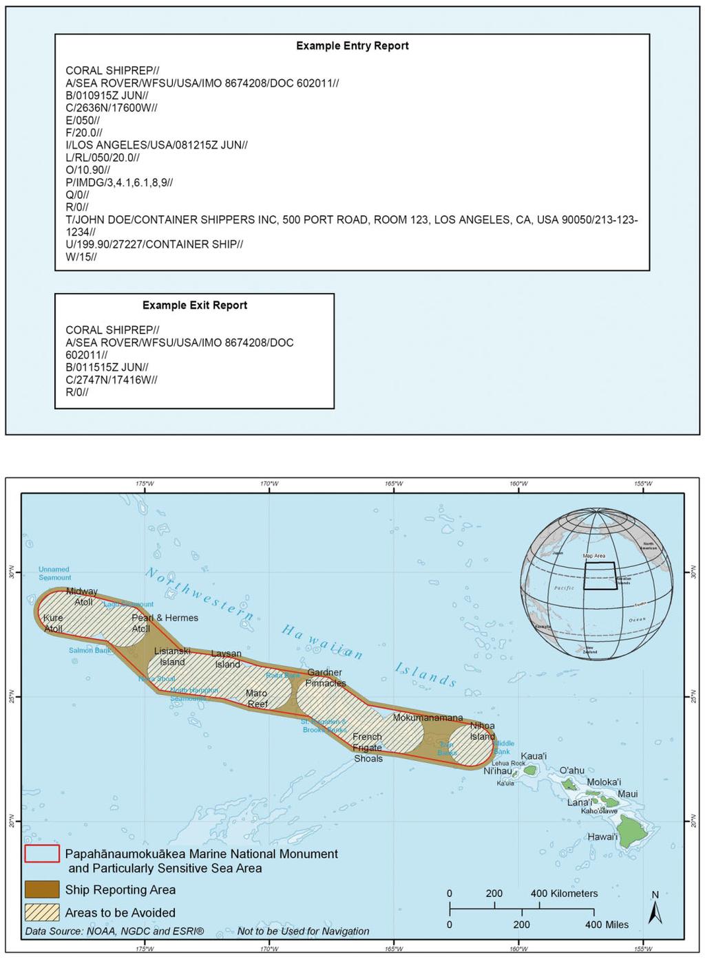
1 UNITED STATES COAST PILOT CORRECTIONS COAST PILOT 7 40 Ed 2008 Change No. 11 LAST NM 25/08 Page 629 Paragraphs 872 to 881; read: The Hawai ian Archipelago and surrounding waters between Nihoa Island and Kure Atoll have been designated as the Northwestern Hawai ian Islands (Papahanaumokuakea) Marine National Monument by Presidential Proclamation 8031 of June 15, Within this Monument are three areas to be noted: A Particularly Sensitive Sea Area (PSSA), Areas to be Avoided, and a Ship Reporting Area. These areas are described in detail below. The Northwestern Hawai ian Islands (Papahanaumokuakea) Marine National Monument encompasses an area of the marine waters and submerged lands of the Northwestern Hawai ian Islands. The seaward boundary of the reserve is 50 miles from the approximate geographical center of Nihoa Island, Necker Island, French Frigate Shoals, Gardner Pinnacles, Maro Reef, Laysan Island, Lisianski Island, Pearl and Hermes Reef, Midway Atoll, and Kure Atoll and includes all areas of the Hawai ian Islands National Wildlife Refuge and Midway Atoll National Wildlife Refuge. (See 50 CFR through , chapter 2, for limits and regulations.) The Particularly Sensitive Sea Area (PSSA) is an IMOdesignated zone sharing the same boundary as the Monument. The area encompasses a 1,200-mile stretch of coral islands, seamounts, banks, and shoals. It is home to more than 7,000 marine species and contains 4,500 square miles of coral reefs. Ship traffic has been identified as one of the primary anthropogenic threats to the vulnerable and valuable natural and cultural resources of the area. PSSA designation augments domestic protective measures by alerting mariners to exercise extreme caution when navigating through the area. The International Maritime Organization (IMO) has adopted certain Areas to be Avoided in the region of the Northwestern Hawai ian Islands (Papahanaumokuakea) Marine National Monument. Given the magnitude of obstacles that make navigation in these areas hazardous and in order to increase: maritime safety, protection of the environment, preservation of cultural resources and areas of cultural importance significant to Native Hawai ians, and facilitate the ability to respond to developing maritime emergencies in the Monument, all ships solely in transit should avoid the following areas contained within a circle having a radius of 50 nautical miles centered upon the following geographical positions: (1) 'N, 'W (Kure Atoll) (2) 'N, 'W (Midway Atoll) (3) 'N, 'W (Pearl and Hermes Atoll) (4) 'N, 'W (Lisianski Island) (5) 'N, 'W (Laysan Island) (6) ' N ' W (Maro Reef) (7) 'N, 'W (Between Maro Reef and Raita Bank) (8) 'N, 'W (Gardner Pinnacles) (9) 'N, 'W (French Frigate Shoals) (10) 'N, 'W (Necker Island) (11) 'N, 'W (Nihoa Island) and the areas encompassed by the following geographical positions: Area 1 (1) 'N., 'W. (2) 'N., 'W. (3) 'N., 'W. (4) 'N., 'W. Area 2 (1) 'N., 'W. (2) 'N., 'W. (3) 'N., 'W. (4) 'N., 'W. A mandatory Ship Reporting System (CORAL SHIP- REP) has been established in the Northwestern Hawai ian Islands (Papahanaumokuakea) Marine National Monument Particularly Sensitive Sea Area for the following vessels entering or departing any U.S. port or place and in transit through the reporting area: (1) All vessels 300 gross tons or greater (2) All vessels experiencing an emergency in the Reporting Area Vessels other than those described above, including sovereign immune vessels, are encouraged to participate. The current notification requirements described in 50 CFR 404.4(b) for U.S. flagged vessels passing through the Monument remain in effect. The reporting area boundary adopted by the IMO generally extends 10 miles out and entirely around the Monument boundary and includes three transit corridors through the Monument PSSA. Vessels using these corridors are asked to report only twice, once when entering the reporting area and once when leaving. These transit corridors are between the designated Areas to be Avoided around: (1) Pearl & Hermes Atoll and Lisianski Island Page 1
2 (2) Maro Reef and Gardner Pinnacles (3) Necker Island and Nihoa Island The reporting area does not include the Areas to be Avoided within the Monument. A vessel that passes through an Area to be Avoided shall notify the shore-based authority when: (1) entering the reporting area (2) leaving the reporting area to enter an Area to be Avoided (3) exiting the Area to be Avoided to enter the reporting area on the other side of the Area (4) leaving the reporting area. The potential burden of reporting four times is justified by the navigation hazards that exist within the Areas to be Avoided. Vessels crossing the reporting area boundary should report immediately (via INMARSAT-C) to the following address: nwhi.notifications@noaa.gov. (Vessels not equipped with INMARSAT-C should report via alternate satellite communications, or prior to, during, or after transiting through the reporting area to the above address.) The entry/exit notifications should be sent in the prescribed format and data syntax shown. Use of batch message routing services which may delay receipt of a report should not be used. Failure to follow the exact format (e.g. extra information, extraneous characters, or double spacing) may cause the automated computer system to reject your report. Telegraphy Name A B C Northwestern Hawaiian Islands (Papahanaumokuakea) Marine National Monument Particularly Sensitive Sea Area (PSSA) Ship Reporting Area Entry Notification Format Function Information Required Example Field Text System identifier Ship Date, time (UTC), and month of entry Position CORAL SHIPREP // Vessel name / call sign / flag / IMO number / Federal documentation or State registration number if applicable // A 6-digit group giving day of month (first two digits), hours and minutes (last four digits) in coordinated universal time, suffixed by the letter Z (indicating time in UTC), and three letters indicating month // A 4-digit group giving latitude in degrees and minutes, suffixed with the letter N (indicating north), followed by a single /, and a five digit group giving longitude in degrees and minutes, suffixed with the letter W (indicating west) // [Report in the World Geodetic System 1984 Datum (WGS-84)] E True course 3-digit number indicating true course // E/180// F I Speed in knots and tenths Destination and estimated time of arrival 3-digit group indicating knots decimal tenths // Name of port city / country / estimated arrival date and time group expressed as in (B) // CORAL SHIPREP// A/OCEAN VOYAGER/C5FU8/BAHAMAS/ IMO // B/271107Z DEC// C/2728N/17356W// F/20.5// I/SEATTLE/USA/311230Z DEC// Page 2
3 L Intended route through the reporting area Route information should be reported as a direct rhumbline (RL) course through the reporting area and intended speed (expressed as in E and F) or a series of way points (WP). Each waypoint entry should be reported as latitude and longitude, expressed as in (C), and intended speed between waypoints (as in F) // (Note: As many L lines as needed may be used to describe the vessel s intended route.) L/RL/215/20.5// -OR- L/WP/2734N/17352W/20.5// L/WP/2641N/17413W/20.5// L/WP/2605N/17530W/20.5// O P Q R T U Vessel draft in meters Categories of Hazardous Cargoes* Defects or deficiencies* * Pollution incident or goods lost overboard** Contact information of ship's agent or owner Ship size (length overall and gross tonnage) and type Maximum present static draft reported in meters decimal centimeters // Classification Code (e.g. IMDG, IBC, IGC, INF) / and all corresponding Categories of Hazardous Cargoes (delimited by commas) // Note: If necessary, use a separate P line for each type of Classification Code. Brief details of defects, damage, deficiencies or limitations that restrict maneuverability or impair normal navigation // (If none, enter the number zero.) Description of pollution incident or goods lost overboard within the Monument, the Reporting Area, or the U.S. Exclusive Economic Zone // (If none, enter the number zero.) Name / address / and phone number of ship's agent or owner // Length overall reported in meters decimal centimeters / number of gross tons / type of ship (e.g. bulk carrier, chemical tanker, oil tanker, gas tanker, container, general cargo, fishing vessel, research, passenger, OBO, RORO) // O/11.50// P/IMDG/1.4G,2.1,2.2,2.3,3,4.1,6.1,8,9// Q/Include details as required// R/0// W Persons Total number of persons on board // W/15// T/JOHN DOE/GENERIC SHIPPING COMPANY INC, 6101 ACME ROAD, ROOM 123, CITY, STATE, COUNTRY 12345/ // U/294.14/54592/CONTAINER SHIP// Page 3
4 * Categories of hazardous cargoes means goods classified in the International Maritime Dangerous Goods (IMDG) Code; substances classified in chapter 17 of the International Code for the Construction and Equipment of Ships Carrying Dangerous Chemicals in Bulk (IBC Code) and chapter 19 of the International Code for the Construction and Equipment of Ships Carrying Liquefied Gases in Bulk (IGC Code); oils as defined in MARPOL Annex I; noxious liquid substances as defined in MARPOL Annex II; harmful substances as defined in MARPOL Annex III; and radioactive materials specified in the Code for the Safe Carriage of the Irradiated Nuclear Fuel, Plutonium and High-Level Radioactive Wastes in Flasks on Board Ships (INF Code). ** In accordance with the provisions of the MARPOL Convention, ships must report information relating to defects, damage, deficiencies or other limitations as well as, if necessary, information relating to pollution incidents or loss of cargo. Safety related reports must be provided to CORAL SHIPREP without delay should a ship suffer damage, failure or breakdown affecting the safety of the ship (Item Q), or if a ship makes a marked deviation from a route, course or speed previously advised (Item L). Pollution or cargo lost overboard must be reported without delay (Item R). Telegraphy Name A B C R Northwestern Hawaiian Islands (Papahanaumokuakea) Marine National Monument Particularly Sensitive Sea Area (PSSA) Ship Reporting Area Exit Notification Format Function Information Required Example Field Text System identifier Ship Date, time (UTC), and month of exit Position Pollution incident or goods lost overboard CORAL SHIPREP// Vessel name / call sign / flag / IMO number / Federal documentation or State registration number if applicable // A 6-digit group giving day of month (first two digits), hours and minutes (last four digits), suffixed by the letter Z indicating time in UTC, and three letters indicating month// A 4-digit group giving latitude in degrees and minutes, suffixed with the letter N (indicating north), followed by a single /, and a five digit group giving longitude in degrees and minutes, suffixed with the letter W (indicating west) // [Report in the World Geodetic System 1984 Datum (WGS-84)] Description of pollution incident or goods lost overboard within the Monument, the Reporting Area, or the U.S. Exclusive Economic Zone // (If none, enter the number zero.) CORAL SHIPREP// A/OCEAN VOYAGER/C5FU8/BAHAMAS/ IMO // B/271657Z DEC// C/2605N/17530W// (CL 287/08; CL 288/08; CL 1038/06; NOS 540) 32/08 R/0// Page 4
5 Page 629 Paragraph 881; insert after: New graphic from back of this Subsection. (CL 287/08; CL 288/08; CL 1038/08; NOS 540) 32/08 COAST PILOT 7 40 Ed 2008 Change No. 12 Page 272 Paragraph 135, line 4; read: regulations.) In September 2005, the U.S. Marine Corps reported testing of the Expeditionary Fighting Vehicle (EFV) 24 hours a day off of Camp Pendleton, from the Oceanside Harbor entrance to San Mateo Point and up to 25 miles off shore. There may be as many as four EFVs testing at the same time with several additional vessels supporting testing in the vicinity of the EFVs. All vessels will have lighting in accordance with regulations. There may be times when spotlights and/or strobe lights will be visible in the test area. All support vessels in the test team will be monitoring radar and VHF-FM channel 81A; the Water Safety Officer will also monitor VHF-FM channel 81A. For additional information contact the Operations Officer at (19/08 CG11; 39/05 CG11) 32/08 COAST PILOT 7 40 Ed 2008 Change No. 13 Page 410 Paragraph 7, lines 1 to 7; read: In July 2007, the controlling depth was 10 feet in the entrance channel to the turning basin, thence depths of 9 to 12 feet were available in the basin; the entrance to the SE basin had a controlling depth of 10 feet (with lesser depths to 3 feet along the W edge) and the barge slip had a depth of 6 feet. An overhead... (BP ) 32/08 Page 429 Paragraph 264, line 1; read: In August 2005-August 2007, the controlling... (BP ) 32/08 Page 441 Paragraph 95, line 4 to Paragraph 96, line 5; read: The pilot boat COLUMBIA is also 72 feet long and has an orange hull and orange superstructure with the word PILOT prominently displayed on the side of the house. When either the CHINOOK or COLUMBIA are used, speed of the vessel should be 12 to 14 knots and the pilot ladder should be rigged 2 meters above the waterline. (CL 570/08) 32/08 Page 477 Paragraph 153; strike out. (16/08 CG13) 32/08 Page 504 Paragraph 268, line 3 to Paragraph 269; read: is wooded. Small pleasure craft anchor in the bights of the N and S shores. A State marine park in the bight of the N shore Page 435 Paragraph 4, line 2; read: and statute miles to nautical miles are in Appendix B. (NOS/08) 32/08 Page 437 Paragraph 43, lines 9 to 11; read: SE to the 27-foot channel. Controlling depths throughout the river channels... (NOS 18526) 32/08 Page 613 Paragraph 642, lines 3 to 5; read: harbor. In June 2007, the controlling depth was 38 feet in the entrance channel to the basin, thence 36 to 38 feet in... (DD 10795; DD 10796) 32/08 has a small seasonal pier, campground, and mooring facilities; limited water is available. A buoy marks the N side of a rocky area on the N side of Jones Island near the entrance of the N bight. Spring Passage separates Jones Island from the SW part of Orcas Island; in general, the passage is free of danger. (13/08 CG13; NOS 18434) 32/08 Page 556 Paragraph 412, line 8; read: basin has from 3 to 5 fathoms. An obstructions with a least depth of 8 feet was reported in the harbor in about 47 20'14"N., '06"W. The surrounding land,... (CL 558/08; NOS 18445) 32/08 Page 606 Paragraphs 548 to 549; read: At times when stormy S or SW (kona) winds create high swells, the channel becomes extremely hazardous. There is usually a strong rip current crossing the channel at this time. (DD 11192) 32/08 Page 655 Paragraph 161, lines 4 to 11; read: ruins (2005). An entrance channel, marked by lighted and unlighted buoys, is entered about ½ mile S of the head of the breakwater and leads NE and NW to a basin off the town of Tinian. In May 2007, the controlling depths were 28 feet (8.5 meters) in the entrance channel with lesser depths to 26 feet (7.9 meters) along the edges of the channel, thence 24 feet (7.3 meters) in the basin. A smokestack is about... (FE 00535; NOS 81071; LL/07) 32/08 Page 5
6 COAST PILOT 7 40 Ed 2008 Change No. 14 Page 416 Paragraph 103; read: Caution Due to the rapid and severe onset of weather from the North Pacific Ocean, anchorage in the ocean outside of Coos Bay is reported not safe and is dangerous during the winter months. Like all unprotected areas along the Oregon coast, large swells and heavy winds characterize the area during the winter. These conditions can suddenly and unexpectedly besiege the unwary with catastrophic results. The prevailing direction of both sell and wind will drive disabled or improperly handled vessels onto the shore. (DD 10000) 32/08 Page 532 Paragraph 126 to Paragraph 127, line 6; read: Elliott Bay Marina isolated just W of Smith Cove (Pier 91) below Magnolia Bluff. A 2,700-foot breakwater, marked by private lights at each end, protects the basin on its S side. The basin has entrances on the E and W ends. In 2007, the reported approach depth was 25 feet with depths of 15 feet in the basin. The concrete floats can accommodate 1,200 craft up to 200 feet long, including 25 transient berths; larger vessel moorage is at the E pier. Electricity (30A, 50A & 100A), gasoline, diesel fuel, water, laundry, showers, groceries, restaurants, marine supplies, fishing supplies and a pump-out station are available. A yacht chartering firm is on site. VHF- FM channel 78A is monitored and a heliport... (DB 16615) 32/08 Page 602 Paragraph 485, lines 5 to 10; read: is open to the S. In June 2007, the basin had depths of 20 to 23 feet with lesser depths to 17 feet at the NE end. The approach to the basin is marked by lighted and unlighted buoys and a 034 lighted range. (DD 10799) 32/08 Page 602 Paragraph 487, lines 1 to 4; read: A boat ramp and mooring area for small craft are just off the N end of the wharf. A channel, marked by private buoys, COAST PILOT 7 40 Ed 2008 Change No. 15 Page 195 Paragraph 3550, line 3; read: 1232 and 50 U.S.C Security zone; waters surrounding U.S. Forces vessel SBX-1, HI. (a) Location. The following area, in U.S. navigable waters within the Honolulu Captain of the Port Zone (see 33 CFR ), from the surface of the water to the ocean leads to a small-boat harbor off the SE side... (LL/07; NOS 19353) 32/08 Page 620 Paragraph 739; read: A Federal project provides for an entrance channel which leads between the outer end of the breakwater and Kukii Point, thence turns SW before entering the harbor basin. The Federal project depths are 40 feet in the entrance channel and 35 feet in the harbor basin. The entrance channel is marked by lights, buoys, and a lighted range. (NOS 19383; CEM-Pacific Ocean/74) 32/08 Page 621 Paragraphs 752 to 753; read: The State of Hawaii, Nawiliwili Piers 1 and 2 (21 57'15"N., '18"W.): 1,285 feet of berthing space with a depth of 35 feet alongside and deck height of 8.8 feet; receipt and shipment of conventional and containerized general cargo; receipt of petroleum products, cements, and bulk fertilizer; shipment of bulk raw sugar and molasses; owned and operated by the State of Hawaii. The State of Hawaii, Nawiliwili Pier 3 (21 57'07"N., '31"W.): 627 feet of berthing space with a depth of 35 feet alongside and a deck height of 8 feet; receipt and shipment of conventional and containerized general cargo and automobiles; receipt of liquefied petroleum gas, lumber, and dry bulk fertilizer; owned and operated by the State of Hawaii. (PS 50/99) 32/08 Page 621 Paragraph 756, line 4; read: Private lights mark the channel inside the harbor. (LL/07) 32/08 Page 622 Paragraph 774; read: A Federal project provides for an entrance channel which leads N past the outer end of the breakwater to a harbor basin in Hanapepe Bay with a project depth of 35 feet in the entrance channel and basin. The harbor basin is marked by lighted and unlighted buoys on the N and W sides. (NOS 19382; CEM-Pacific Ocean/45) 32/08 floor, is a security zone: All waters extending 500 yards in all directions from U.S. Forces vessel SBX-1. The security zone moves with the SBX 1 while it is in transit and becomes fixed when the SBX 1 is anchored, position-keeping, or moored. (b) Regulations. The general regulations governing security zones contained in 33 CFR apply. Entry into, transit through, or anchoring within this zone while it is activat- Page 6
7 ed, and thus subject to enforcement, is prohibited unless authorized by the Captain of the Port or a designated representative thereof. (c) Suspension of enforcement. The Coast Guard will suspend enforcement of the security zone described in this section whenever the SBX 1 is within the Honolulu Defensive Sea Area (see 6 FR 6675). (d) Information notice. The Captain of the Port of Honolulu will cause notice of the enforcement of the security zone described in this section to be made by broadcast notice to mariners. The SBX 1 is easy to recognize because it contains a large white object shaped like an egg supported by a platform that is larger than a football field. The platform in turn is supported by six pillars similar to those on large oildrilling platforms. (e) Authority to enforce. Any Coast Guard commissioned, warrant, or petty officer, and any other Captain of the Port representative permitted by law, may enforce the security zone described in this section. (f) Waiver. The Captain of the Port may waive any of the requirements of this rule for any person, vessel, or class of vessel upon finding that application of the security zone is unnecessary or impractical for the purpose of maritime security. (g) Penalties. Vessels or persons violating this rule are subject to the penalties set forth in 33 U.S.C and 50 U.S.C (FR 3/12/08) 32/08 Page 7
8 Page 8
SECTION II NM 11/13 NAVIGATION PUBLICATIONS COAST PILOT CORRECTIONS. Chapter 4 Paragraphs 85 to 86; read: (85)
") NAVIGATION PUBLICATIONS COAST PILOT CORRECTIONS COAST PILOT 1 42 Ed 2012 Change No. 13 LAST NM 9/13 Chapter 4 Paragraph 9; read: (9) Round Rock, which uncovers, and The Boring Stone, 3 feet high and bare,
NAVIGATION PUBLICATIONS COAST PILOT CORRECTIONS COAST PILOT 1 42 Ed 2012 Change No. 13 LAST NM 9/13 Chapter 4 Paragraph 9; read: (9) Round Rock, which uncovers, and The Boring Stone, 3 feet high and bare,
SECTION II NM 26/10 NAVIGATION PUBLICATIONS ALMANACS CORRECTIONS
 NAVIGATION PUBLICATIONS ALMANACS CORRECTIONS NAUTICAL ALMANAC Ed 2011 NEW EDITION (NGA) 26/10 SAILING DIRECTIONS CORRECTIONS PUB 140 8 Ed 2010 NEW EDITION (NGA) 26/10 COAST PILOT CORRECTIONS COAST PILOT
Executive Order on the activities of pilotage service providers and the obligations of pilots
 Unofficial translation Executive Order on the activities of pilotage service providers and the obligations of pilots EXECUTIVE ORDER no. 1199 of 01/12/2006 (In force) Legislation affected by the regulation
LOCAL NOTICE TO MARINERS
 USCG Notice to Mariners 3/7/18 (View full Notice here) LNM 10/18 Coast Guard District 1: U.S. Department of Homeland Security United States Coast Guard LOCAL NOTICE TO MARINERS COASTAL WATERS FROM EASTPORT,
RESOLUTION MSC.161(78) (adopted on 17 May 2004) AMENDMENTS TO THE EXISTING MANDATORY SHIP REPORTING SYSTEM "THE TORRES STRAIT AND INNER ROUTE OF THE
 (adopted on 17 May 2004) AMENDMENTS TO THE EXISTING MANDATORY SHIP REPORTING SYSTEM THE TORRES STRAIT AND INNER ROUTE OF THE") MSC 78/26/Add.2 RESOLUTION MSC.161(78) REPORTING SYSTEM THE TORRES STRAIT AND INNER ROUTE OF THE GREAT BARRIER REEF THE MARITIME SAFETY COMMITTEE, RECALLING Article 28(b) of the Convention on the International
MSC 78/26/Add.2 RESOLUTION MSC.161(78) REPORTING SYSTEM THE TORRES STRAIT AND INNER ROUTE OF THE GREAT BARRIER REEF THE MARITIME SAFETY COMMITTEE, RECALLING Article 28(b) of the Convention on the International
Port of Port Elizabeth Information
 LOCATION Latitude 34º 01 S Longitude 25º 42 E PILOTAGE Pilotage is compulsory. Rendezvous point is 2.2 nautical miles NE of the port entrance on the leading lights. Pilot transfer is by pilot boat, unless
PILOTAGE DIRECTIONS REVIEWED DECEMBER 2016
 PILOTAGE DIRECTIONS REVIEWED DECEMBER 2016 REVISION LIST Revision No. Date Details Approved by: Original All sections 12 Dec 2013 First edition of C W Brand v1.0 Pilotage Directions Revision 2 all sections
U. S. Coast Guard Sector Boston Merrimack River Approach and Entrance, MA. Waterways Management Survey
 U. S. Coast Guard Sector Boston Merrimack River Approach and Entrance, MA. Waterways Management Survey The Waterways Analysis and Management Survey (WAMS) process is an essential component of both the
BookletChart. Intracoastal Waterway Matecumbe to Grassy Key NOAA Chart A reduced-scale NOAA nautical chart for small boaters
 BookletChart Intracoastal Waterway Matecumbe to Grassy Key NOAA Chart 11449 A reduced-scale NOAA nautical chart for small boaters When possible, use the full-size NOAA chart for navigation. Published by
Pilotage Directions 2017
 Pilotage Directions 2017 1. Commencement These Pilotage Directions shall come into force on 31 st August 2017 on which date the existing Pilotage Directions are revoked. 2. Short Title These Pilotage Directions
ADANI PORTS & SEZ LTD. ++ MUNDRA PORT ++ GENERAL INFORMATION
 ADANI PORTS & SEZ LTD. ++ MUNDRA PORT ++ GENERAL INFORMATION LOCATION Mundra Port is all weather, independent, commercial port with geographical and hydrological advantages on the West Coast of India,
LOCAL NOTICE TO MARINERS
 USCG Notice to Mariners 3/26/15 (View full Notice here) LNM 12/15 Coast Guard District 1 : U.S. Department of Homeland Security United States Coast Guard LOCAL NOTICE TO MARINERS COASTAL WATERS FROM EASTPORT,
SOLAS requirements for nonpassenger ships 300 or above but less than 500 gross tonnage
 SOLAS requirements for nonpassenger ships 300 or above but less than 500 gross tonnage Guidance for owners, masters and surveyors for ships undertaking international voyages SOLAS requirements applied
BookletChart. Sand Key to Rebecca Shoal NOAA Chart A reduced-scale NOAA nautical chart for small boaters
 BookletChart Sand Key to Rebecca Shoal NOAA Chart 11439 A reduced-scale NOAA nautical chart for small boaters When possible, use the full-size NOAA chart for navigation. Published by the National Oceanic
AK-APC-NTV Operating Procedures for Cargo and Passenger Non Tank Vessels Transiting and Operating in Alaska Waters December 26, 2015
 AK-APC-NTV Operating Procedures for Cargo and Passenger Non Tank Vessels Transiting and Operating in Alaska Waters December 26, 2015 The Alternative Planning Criteria (APC) Operating Procedures were developed
Code of Federal Regulations
 Page 1 of 6 Code of Federal Regulations Title 33 - Navigation and Navigable Waters Volume: 2 Date: 2010-07-01 Original Date: 2010-07-01 Title: Section 165.1325 - Regulated Navigation Areas; Bars Along
Delaware River Vessel Reporting System Mariners Advisory Committee For
 Delaware River Vessel Reporting System Mariners Advisory Committee For the Bay and River Delaware The Mariner's Advisory Committee is comprised of Master Mariners, River Pilots, and concerns itself with
How To Enter Kushiro Port and Things To Be Aware of When Entering
 How To Enter Kushiro Port and Things To Be Aware of When Entering 1.How to enter Kushiro Port (1)How to enter the East Area When entering the port from Nemuro, navigate while maintaining a safe distance
COOPERATIVE VESSEL TRAFFIC SERVICE (CVTS) TAMPA BAY, FLORIDA
 TAMPA BAY, FLORIDA") COOPERATIVE VESSEL TRAFFIC SERVICE (CVTS) TAMPA BAY, FLORIDA USERS MANUAL Oct 2010 1 st Edition Serving the Port of Tampa, Port Manatee, Port of Saint Petersburg, and the Waterways of Tampa Bay 1 Table
COOPERATIVE VESSEL TRAFFIC SERVICE (CVTS) TAMPA BAY, FLORIDA USERS MANUAL Oct 2010 1 st Edition Serving the Port of Tampa, Port Manatee, Port of Saint Petersburg, and the Waterways of Tampa Bay 1 Table
The Maritime Law Association of Australia and New Zealand
 The Maritime Law Association of Australia and New Zealand Protecting the Environment and Promoting Safe Navigation: Australia s System of Pilotage in the Torres Strait Adam McCarthy Assistant Secretary
Newport to San Diego Race April 26-28, 2019 SAILING INSTRUCTIONS
 Newport to San Diego Race April 26-28, 2019 SAILING INSTRUCTIONS The notation [DP] in a rule in the SI means that the penalty for a breach of that rule may, at the discretion of the protest committee,
ROUTEING MEASURES OTHER THAN TRAFFIC SEPARATION SCHEMES
 E 4 ALBERT EMBANKMENT LONDON SE1 7SR Telephone: +44 (0)20 7735 7611 Fax: +44 (0)20 7587 3210 SN.1/Circ.317 4 December 2012 ROUTEING MEASURES OTHER THAN TRAFFIC SEPARATION SCHEMES 1 The Maritime Safety
3.9 Marine Transportation
 3.9 Marine Transportation 3. Affected Environment and Environmental Analysis 3.9 Marine Transportation 3.9.1 Introduction This section describes existing marine vessel transportation within the Port, the
Gorgon - Pilotage - Passage Plan Materials Offloading Facility (MOF) to PBG
 to PBG") Gorgon - Pilotage - Passage Plan Materials Offloading Facility (MOF) to PBG 1.0 Introduction Vessels transiting within port limits from the Materials Offloading Facility (MOF) to the Barrow Island Pilot
Gorgon - Pilotage - Passage Plan Materials Offloading Facility (MOF) to PBG 1.0 Introduction Vessels transiting within port limits from the Materials Offloading Facility (MOF) to the Barrow Island Pilot
SAILING INSTRUCTIONS
 2009 Transpacific Yacht Race SAILING INSTRUCTIONS The Transpac Notice of Race and the Notice of Race Amendments are integral parts of these Sailing Instructions. To avoid confusion, the numbering of the
LIST OF NOTICES TO MARINERS 2017 PAC 201 JUAN DE FUCA STRAIT AND STRAIT OF GEORGIA, FIRST EDITION, 2012
 1 Chapter 1 After paragraph 154 Insert: 154.1 Pacific Gateway Marina (250-412-5509) is located west of the community wharf. Moorage, gas, diesel, a launching ramp and deep water berths for sailboats are
Gorgon - Pilotage - Passage Plan PBG to Materials Offloading Facility (MOF)
") 1.0 Introduction Vessels transiting within port limits from the Barrow Island Pilot Boarding Ground (PBG) to the require an approved passage plan which can be shared between Pilots and vessel Masters.
1.0 Introduction Vessels transiting within port limits from the Barrow Island Pilot Boarding Ground (PBG) to the require an approved passage plan which can be shared between Pilots and vessel Masters.
29 cfr. 33 cfr. 46 US Code (Annotated) 46 cfr CHAPTER II CHAPTER I
 46 cfr CHAPTER II CHAPTER I") 29 cfr Captain Joe's DECK LICENSE PROGRAM G Documentation and Measurement of Vessels H Passenger Vessels 1902 Develop And Enforce Of State Standards I Cargo and Misc. Vessels 1903 Inspections, Citations
29 cfr Captain Joe's DECK LICENSE PROGRAM G Documentation and Measurement of Vessels H Passenger Vessels 1902 Develop And Enforce Of State Standards I Cargo and Misc. Vessels 1903 Inspections, Citations
LOWER MISSISSIPPI RIVER PRE-ENTRY INFORMATION
 LOWER MISSISSIPPI RIVER PRE-ENTRY INFORMATION Notice of Arrivals Prior to Arrival at any U.S. port, the vessel master should ensure a complete and accurate Notice of Arrival has been submitted to National
World Shipping Council. U.S. Coast Guard. Port Access Route Study: The Atlantic Coast From Maine to Florida
 Comments of the World Shipping Council Submitted to the U.S. Coast Guard In the matter of Port Access Route Study: The Atlantic Coast From Maine to Florida Docket Number: USCG-2011-0351 April 13, 2016
Harbourmaster s Office Operation of Superyacht in the Auckland Region Navigation Safety Operating Requirements
 Harbourmaster s Office Operation of Superyacht in the Auckland Region Navigation Safety Operating Requirements Foreword Maritime Rule 90 requires that every vessel of 500 Gross tonnage or greater carries
Important Information for Yachts & Agents
 Important Information for Yachts & Agents 1. The Yacht Services of Alaska agent is your contact for all requests for pilotage and pilot boat services. Refer all communication regarding pilotage to them.
SAILING INSTRUCTIONS. Port of Los Angeles Harbor Cup Cal Maritime Invitational Intercollegiate Regatta March 9 th -11 th, RULES
 SAILING INSTRUCTIONS Port of Los Angeles Harbor Cup Cal Maritime Invitational Intercollegiate Regatta March 9 th -11 th, 2018 1 RULES 1.1 The regatta will be governed by the ICSA Procedural Rules (PR),
THE REPUBLIC OF LIBERIA LIBERIA MARITIME AUTHORITY
 Office of Deputy Commissioner of Maritime Affairs THE REPUBLIC OF LIBERIA LIBERIA MARITIME AUTHORITY Marine Notice NAV-003 Rev. 06/12 TO: SUBJECT: ALL SHIPOWNERS, OPERATORS, MASTERS AND OFFICERS OF MERCHANT
LAW AND PUBLIC SAFETY BOAT REGULATION COMMISSION MOTOR VEHICLE COMMISSION. Readoption with Amendments: N.J.A.C. 13:82. Boating Regulations
 LAW AND PUBLIC SAFETY BOAT REGULATION COMMISSION MOTOR VEHICLE COMMISSION Readoption with Amendments: N.J.A.C. 13:82 Boating Regulations Proposed: August 17, 2009 at 41 N.J.R. 3033(a). Adopted: November
U.S. Coast Guard Sector Mobile
 U.S. Coast Guard Sector Mobile Maritime Severe Weather Contingency Port Plan A Guide to Port Planning and Preparation X-2-1 TABLE OF CONTENTS INTRODUCTION Background 1 Authority 1 Applicability and Purpose
SAFETY OF NAVIGATION STANDARDS IN THE PORTS OF NAUTICAL TOURISM WITH A SPECIAL FOCUS ON THE MAINTENANCE OF THE PORT ORDER
 SAFETY OF NAVIGATION STANDARDS IN THE PORTS OF NAUTICAL TOURISM WITH A SPECIAL FOCUS ON THE MAINTENANCE OF THE PORT ORDER Ranka Petrinović, Ph. D, Full Professor Nikola Mandić, Ph. D, Assistant Professor
On Approval of Compulsory Regulations at Sea Port Kavkaz
 Registered at Russia Ministry of Justice dated June 25, 2013 N 28887 -------------------------------------------------- ----------------------------------- Russian Federation Ministry of Transport Order
GUIDELINES FOR NAVIGATION UNDER THE CONFEDERATION BRIDGE
 (12/2009) GUIDELINES FOR NAVIGATION UNDER THE CONFEDERATION BRIDGE REVISION 1 DECEMBER 2009 Responsible Authority The Regional Director Marine Safety Atlantic Region is responsible for this document, including
This direction contains the requirements for the compulsory pilotage areas within the Auckland region. This
 Harbourmaster s Direction 2-15 Pilotage Foreword This direction contains the requirements for the compulsory pilotage areas within the Auckland region. This direction updates and supersedes previous Harbourmaster
World Shipping Council. Bureau of Ocean Energy Management Department of the Interior
 Comments of the World Shipping Council Submitted to the Bureau of Ocean Energy Management Department of the Interior In the matter of Commercial Leasing for Wind Power Development on the Outer Continental
International regulations and guidelines for maritime spatial planning related to safe distances to multiple offshore structures (e.g.
 International regulations and guidelines for maritime spatial planning related to safe distances to multiple offshore structures (e.g. wind farms) Introduction This is a summary of the most important international
33 CFR Ch. I ( Edition)
") 151.1512 (b) No master of a vessel subject to this subpart shall separately discharge sediment from tanks or holds containing ballast water unless it is disposed of ashore in accordance with local requirements.
151.1512 (b) No master of a vessel subject to this subpart shall separately discharge sediment from tanks or holds containing ballast water unless it is disposed of ashore in accordance with local requirements.
C H A P T E R X X V. Prevention of pollution by garbage from ships
 Only the Danish version is authentic Notice D XXV 1 November 2004 Technical regulation on the construction and equipment, etc. of passenger ships on domestic voyages C H A P T E R X X V Prevention of pollution
Equivalent arrangements accepted under the 1974 SOLAS Convention and the 1966 Load Lines Convention. Notification by the Government of France
 INTERNATIONAL MARITIME ORGANIZATION 4 ALBERT EMBANKMENT LONDON SE1 7SR Telephone: 020 7735 7611 Fax: 020 7587 3210 IMO E Ref. T4/5.03 Circular letter No.2988 T1/2.08 7 August 2009 To: All IMO Members Contracting
2019 Newport to Ensenada Race (N2E) April 26-28, 2019 SAILING INSTRUCTIONS
 April 26-28, 2019 SAILING INSTRUCTIONS") 2019 Newport to Ensenada Race (N2E) April 26-28, 2019 SAILING INSTRUCTIONS The notation [DP] in a rule in the SI means that the penalty for a breach of that rule may, at the discretion of the protest committee,
2019 Newport to Ensenada Race (N2E) April 26-28, 2019 SAILING INSTRUCTIONS The notation [DP] in a rule in the SI means that the penalty for a breach of that rule may, at the discretion of the protest committee,
MARPOL 73/78. Annex V Regulations for the Prevention of Pollution by Garbage from Ships
 MARPOL 73/78 Annex V Regulations for the Prevention of Pollution by Garbage from Ships Garbage All kinds of victual, domestic and operational waste excluding fresh fish and parts thereof, generated during
APC Operating Procedures Oil Tankers
 APC Operating Procedures Oil Tankers August 2013 The APC Operating Procedures were developed to aid the Master and Operator of oil tankers in ensuring all aspects of the APC are complied with when transiting
CHAPTER 6 10/29/2018 Clean Version REGULATING PIERS, WHARVES, MOORING BUOYS, SWIMMING RAFTS AND INFLATABLES ON ROCK LAKE
 1 2 3 4 5 6 7 8 9 10 11 12 13 14 15 16 17 18 19 20 21 22 23 24 25 26 27 28 29 30 31 32 33 34 35 36 37 38 39 40 41 42 43 44 45 46 CHAPTER 6 10/29/2018 Clean Version REGULATING PIERS, WHARVES, MOORING BUOYS,
: AUTHORITY: This ordinance is adopted under the authority granted by Section 30.13(2) and 30.13(3) of the Wisconsin Statutes.
 and 30.13(3) of the Wisconsin Statutes.") 1 2 3 4 5 6 7 8 9 10 11 12 13 14 15 16 17 18 19 20 21 22 23 24 25 26 27 28 29 30 31 32 33 34 35 36 37 38 39 40 41 42 43 44 45 CHAPTER 6 REGULATING PIERS, WHARVES, MOORING BUOYS, RAFTS, AND INFLATABLES
1 2 3 4 5 6 7 8 9 10 11 12 13 14 15 16 17 18 19 20 21 22 23 24 25 26 27 28 29 30 31 32 33 34 35 36 37 38 39 40 41 42 43 44 45 CHAPTER 6 REGULATING PIERS, WHARVES, MOORING BUOYS, RAFTS, AND INFLATABLES
The LA/LB Harbors handle more than 5,500 commercial vessel arrivals per year (excluding local coastwise and Catalina Island traffic).
.") X. SMALL CRAFT For the purpose of the Los Angeles and Long Beach Harbor Safety Plan, pleasure vessels, commercial fishing vessels and sportfishing boats are designated as small craft. A. BACKGROUND: The
X. SMALL CRAFT For the purpose of the Los Angeles and Long Beach Harbor Safety Plan, pleasure vessels, commercial fishing vessels and sportfishing boats are designated as small craft. A. BACKGROUND: The
Wexford Harbour. Yachting Guide. Navigation
 Wexford Harbour Yachting Guide Navigation This document supersedes all previous editions. Approvals: Yacht Club Committee April, 2015 Wexford Board of Directors April, 2015 # Date Section Revision 1 6.5.2015
SUMMARY: The Coast Guard is establishing a temporary 500 yard safety zone around the
 This document is scheduled to be published in the Federal Register on 06/13/2017 and available online at https://federalregister.gov/d/2017-12163, and on FDsys.gov 9110-04-P DEPARTMENT OF HOMELAND SECURITY
ST. VINCENT AND THE GRENADINES
 ST. VINCENT AND THE GRENADINES MARITIME ADMINISTRATION CIRCULAR N SOL 036 Amendment to SOLAS 1974 as amended, Resolution MSC.256 (84) TO: SHIPOWNERS & SHIPS OPERATORS & MANAGERS, MASTERS SURVEYORS TO FLAG
OSAKA MARTIS USER MANUAL TABLE OF CONTENTS
 OSAKA MARTIS USER MANUAL TABLE OF CONTENTS Ⅰ Ⅱ Ⅲ INTRODUCTION OPERATIONAL CONCEPT OF "Osaka MARTIS" IMPORTANT NAVIGATIONAL RULES Ⅳ COMMUNICATION 1 VHF Channels 2 Language Ⅴ PRE-ENTRY REPORT AND POSITION
KANMON KAIKYO VESSEL TRAFFIC SERVICE CENTER KANMON MARTIS USER MANUAL TABLE OF CONTENTS Ⅱ OPERATIONAL CONCEPT OF THE "KANMON MARTIS" 1
 KANMON KAIKYO VESSEL TRAFFIC SERVICE CENTER KANMON MARTIS USER MANUAL TABLE OF CONTENTS Ⅰ INTRODUCTION 1 Ⅱ OPERATIONAL CONCEPT OF THE "KANMON MARTIS" 1 Ⅲ IMPORTANT NAVIGATIONAL RULES 2 Ⅳ COMMUNICATION
World Shipping Council. Bureau of Ocean Energy Management U.S. Department of the Interior
 Comments of the World Shipping Council Submitted to the Bureau of Ocean Energy Management U.S. Department of the Interior In the matters of Commercial Leasing for Wind Power Development on the Outer Continental
Dr Sam BATEMAN, Australian National Centre for Ocean Resources and Security, University of Wollongong
 Dr Sam BATEMAN, Australian National Centre for Ocean Resources and Security, University of Wollongong sbateman@uow.edu.au Coastal State regulation of navigation in adjacent waters is increasing Shipping
2005 ABC. Chapter 3 Part 2. Navigating with ATON's. Revision to D-13 Local Notes. Instructor Notes for Mike Brough. Mike Brough
 2005 ABC Chapter 3 Part 2 Navigating with ATON's Revision to D-13 Local Notes Instructor Notes for Mike Brough Mike Brough June 24 2008 June 24 2008 Slide 1 June 24 2008 New graphics Navigating on Water
Technical Information
 Subject Medical Oxygen Cylinder onboard Tuvalu flagged Ships To whom it may concern Technical Information No. TEC-1037 Date 31 July 2015 The Tuvalu Government has notified ClassNK of the special requirements
Aids to navigation can include buoys, day beacons, range markers, and lighthouses.
 This boating safety course manual has been approved by Transport Canada strictly on the basis that it meets the minimum requirements of basic boating safety knowledge set out in Transport Canada s Boating
Safety Zones and Special Local Regulations; Recurring. Marine Events in Captain of the Port Long Island Sound Zone
 This document is scheduled to be published in the Federal Register on 05/19/2015 and available online at http://federalregister.gov/a/2015-12103, and on FDsys.gov 9110-04-P DEPARTMENT OF HOMELAND SECURITY
ANNEX 2 RESOLUTION MEPC.124(53) Adopted on 22 July 2005 GUIDELINES FOR BALLAST WATER EXCHANGE (G6) THE MARINE ENVIRONMENT PROTECTION COMMITTEE,
 Adopted on 22 July 2005 GUIDELINES FOR BALLAST WATER EXCHANGE (G6) THE MARINE ENVIRONMENT PROTECTION COMMITTEE,") Page 1 RESOLUTION MEPC.124(53) Adopted on 22 July 2005 GUIDELINES FOR BALLAST WATER EXCHANGE (G6) THE MARINE ENVIRONMENT PROTECTION COMMITTEE, RECALLING Article 38(a) of the Convention on the International
Page 1 RESOLUTION MEPC.124(53) Adopted on 22 July 2005 GUIDELINES FOR BALLAST WATER EXCHANGE (G6) THE MARINE ENVIRONMENT PROTECTION COMMITTEE, RECALLING Article 38(a) of the Convention on the International
Incident Management Guidelines for Initial Actions and Communications
 Lower Columbia Region Harbor Safety Committee Incident Management Guidelines for Initial Actions and Communications Page 1 of 16 Table of Contents A. INCIDENT MANAGEMENT GUIDELINES... 3 1. PURPOSE... 3
MARINE CIRCULAR MC-25/2012/1
 Singapore Operations Office: 10 Anson Road #25-16, International Plaza, Singapore 079903 Tel: (65) 6224 2345 Fax: (65) 6227 2345 Email: info@tvship.com Website: www.tvship.com 4/2013 MARINE CIRCULAR MC-25/2012/1
PANAMA CANAL AUTHORITY
 OFFICIAL Item No. 1060.0000 1060.0000 CN 10/1/98 1/1/01 PILOTAGE General: (1) Pilotage is charged at fees and is subject to the conditions contained in this tariff section. Pilotage services are furnished
2017 San Francisco Bay Area Leukemia Cup Sunday, October 22
 2017 San Francisco Bay Area Leukemia Cup Sunday, October 22 SAILING INSTRUCTIONS Organizing Authority: The San Francisco Yacht Club (SFYC), Belvedere, California 1 RULES 1.1 The regatta will be governed
Severe Weather Planning Information. Maritime Stakeholders
 Severe Weather Planning Information for the Maritime Stakeholders Port Arthur Captain of the Port Zone Sabine-Neches Waterway, Calcasieu Waterway and Gulf Intracoastal Waterway Revised: May 2018 INTRODUCTION
ANNEX 2. RESOLUTION MSC.256(84) (adopted on 16 May 2008)
 (adopted on 16 May 2008)") RESOLUTION MSC.256(84) (adopted on 16 May 2008) ADOPTION OF AMENDMENTS TO THE INTERNATIONAL CONVENTION FOR THE SAFETY OF LIFE AT SEA, 1974, AS AMENDED THE MARITIME SAFETY COMMITTEE, RECALLING Article 28(b)
RESOLUTION MSC.256(84) (adopted on 16 May 2008) ADOPTION OF AMENDMENTS TO THE INTERNATIONAL CONVENTION FOR THE SAFETY OF LIFE AT SEA, 1974, AS AMENDED THE MARITIME SAFETY COMMITTEE, RECALLING Article 28(b)
Marine Safety Information Bulletin COAST GUARD GUIDANCE FOR DEAD SHIP MOVEMENT IN SECTOR HONOLULU CAPTAIN OF THE PORT ZONE.
 Marine Safety Information Bulletin 16-002 U.S. DEPARTMENT OF HOMELAND SECURITY U. S. Coast Guard Sector Honolulu Sand Island Parkway Honolulu, Hawaii 96819 (808) 842-2600 COAST GUARD GUIDANCE FOR DEAD
GULF OF MEXICO. 268 U.S. Coast Pilot 5, Chapter 6 04 AUG (see catalog for complete coverage) General Index of Chart Coverage in Chapter 6
 General Index of Chart Coverage in Chapter 6") 268 U.S. Coast Pilot 5, Chapter 6 04 AUG 2013 General Index of Chart Coverage in Chapter 6 (see catalog for complete coverage) 11406 11405 11404 11383 11384 11382 11388 11392 11391 11389 11390 11393 88
268 U.S. Coast Pilot 5, Chapter 6 04 AUG 2013 General Index of Chart Coverage in Chapter 6 (see catalog for complete coverage) 11406 11405 11404 11383 11384 11382 11388 11392 11391 11389 11390 11393 88
HARBOR INFRASTRUCTURE INVENTORIES Fairport Harbor, OH
 HARBOR INFRASTRUCTURE INVENTORIES Fairport Harbor, OH Harbor Location: Fairport Harbor is located at the mouth of the Grand River on the southern shore of Lake Erie in the city of Fairport, OH, approximately
Admiralty Leisure Folio SC5601 East Devon and Dorset Coast, Exmouth to Christchurch
 Admiralty Leisure Folio SC5601 East Devon and Dorset Coast, Exmouth to Christchurch The Notices to Mariners (NMs) listed below apply to the latest edition of SC5601 (11 th Edition) published on 24 th March
RESOLUTION MEPC.136(53) Adopted on 22 July 2005 DESIGNATION OF THE BALTIC SEA AREA AS A PARTICULARLY SENSITIVE SEA AREA
 Adopted on 22 July 2005 DESIGNATION OF THE BALTIC SEA AREA AS A PARTICULARLY SENSITIVE SEA AREA") MEPC 53/24/Add.2 RESOLUTION MEPC.136(53) THE MARINE ENVIRONMENT PROTECTION COMMITTEE, BEING AWARE of the ecological, social, economic, cultural, scientific and educational value of the Baltic Sea Area,
MEPC 53/24/Add.2 RESOLUTION MEPC.136(53) THE MARINE ENVIRONMENT PROTECTION COMMITTEE, BEING AWARE of the ecological, social, economic, cultural, scientific and educational value of the Baltic Sea Area,
HARBOR INFRASTRUCTURE INVENTORIES West Harbor, OH
 HARBOR INFRASTRUCTURE INVENTORIES West Harbor, OH Harbor Location: West Harbor is located on the southern shore of Lake Erie in the township of Catawba Island, OH about 50 miles east of Toledo, OH. Authority:
MARINE SAFETY REGULATION 2016 EXEMPTION ORDER. Clause 140(1)
") MARINE SAFETY REGULATION 2016 EXEMPTION ORDER Clause 140(1) I, Angus Mitchell, Executive Director, NSW Maritime, a delegate of Roads and Maritime Services (RMS), pursuant to clause 140(1) of the Marine
MARINE SAFETY REGULATION 2016 EXEMPTION ORDER Clause 140(1) I, Angus Mitchell, Executive Director, NSW Maritime, a delegate of Roads and Maritime Services (RMS), pursuant to clause 140(1) of the Marine
33 rd America s Cup Match ( Match ) Société Nautique de Genève ( Organising Authority ) Valencia, Spain NOTICE OF RACE ( NOR )
 Société Nautique de Genève ( Organising Authority ) Valencia, Spain NOTICE OF RACE ( NOR )") 33 rd America s Cup Match ( Match ) From 1 st February 2010 to 25 th February 2010 Société Nautique de Genève ( Organising Authority ) Valencia, Spain NOTICE OF RACE ( NOR ) 1. RULES 1.1 In accordance
33 rd America s Cup Match ( Match ) From 1 st February 2010 to 25 th February 2010 Société Nautique de Genève ( Organising Authority ) Valencia, Spain NOTICE OF RACE ( NOR ) 1. RULES 1.1 In accordance
HELSINKI COMMISSION HELCOM SAFE NAV 4/2014 Group of Experts on Safety of Navigation Fourth Meeting Helsinki, Finland, 4 February 2014
 HELSINKI COMMISSION HELCOM SAFE NAV 4/2014 Group of Experts on Safety of Navigation Fourth Meeting Helsinki, Finland, 4 February 2014 Agenda Item 3 Accidents and ship traffic in the Baltic Sea Document
SPINNAKER CUP 2010 San Francisco To Monterey Friday, May 28, 2010 SAILING INSTRUCTIONS
 SPINNAKER CUP 2010 San Francisco To Monterey Friday, May 28, 2010 SAILING INSTRUCTIONS Organizing Authorities: The San Francisco Yacht Club, Belvedere, CA and Monterey Peninsula Yacht Club, Monterey, CA
STANDARD PILOTAGE CONDITIONS
 STANDARD PILOTAGE CONDITIONS (Revised on 1st January 2009) THE TOKYO BAY LICENCED PILOTS' ASSOCIATION 1 STANDARD PILOTAGE CONDITIONS (Revised on 1st January 2009) Chapter I General Conditions (Scope of
BookletChart. Chesapeake Bay Severn and Magothy Rivers NOAA Chart A reduced-scale NOAA nautical chart for small boaters
 BookletChart Chesapeake Bay Severn and Magothy Rivers NOAA Chart 12282 A reduced-scale NOAA nautical chart for small boaters When possible, use the full-size NOAA chart for navigation. Published by the
Translation from Estonian version, approved by Villu Vatsfeld, CEO of Saarte Liinid Ltd., on 11 th of June 2018 RINGSU PORT RULES
 Translation from Estonian version, approved by Villu Vatsfeld, CEO of Saarte Liinid Ltd., on 11 th of June 2018 RINGSU PORT RULES 1. GENERAL PART 3 1.1. Type of commercial undertaking of the port authority
RESOLUTION MSC.236(82) (adopted on 1 December 2006) ADOPTION OF AMENDMENTS TO THE GUIDELINES FOR THE TRANSPORT AND HANDLING OF LIMITED AMOUNTS OF
 (adopted on 1 December 2006) ADOPTION OF AMENDMENTS TO THE GUIDELINES FOR THE TRANSPORT AND HANDLING OF LIMITED AMOUNTS OF") RESOLUTION MSC.236(82) (adopted on 1 December 2006) ADOPTION OF AMENDMENTS TO THE GUIDELINES FOR THE TRANSPORT AND HANDLING OF LIMITED AMOUNTS OF HAZARDOUS AND NOXIOUS LIQUID SUBSTANCES IN BULK THE MARITIME
RESOLUTION MSC.236(82) (adopted on 1 December 2006) ADOPTION OF AMENDMENTS TO THE GUIDELINES FOR THE TRANSPORT AND HANDLING OF LIMITED AMOUNTS OF HAZARDOUS AND NOXIOUS LIQUID SUBSTANCES IN BULK THE MARITIME
HARBOR INFRASTRUCTURE INVENTORIES Caseville Harbor, Michigan
 HARBOR INFRASTRUCTURE INVENTORIES Caseville Harbor, Michigan Harbor Location: Caseville Harbor is located at the mouth of the Pigeon River on the east shore of Saginaw Bay, about 17 miles southwest of
West Coast Anchorages
 West Coast Anchorages This document aims to catalogue a number of anchorages along the West Coast of Tasmania where shelter may be sought. In addition the degree of protection from the wind, and holding
Port Sections Guide Section 01
 s Guide 01 Cow Bay Marina Date 10/1/2016 Position (lat / lon) Minimum controlled water depth Chart datum Range of water densities Tidal range alongside Bottom type Dredging regime Distance pilot station
 1 of 3 11/21/2013 3:25 PM Pilotage for Crossing the Outer Bar of Mobile Bay or Navigating a Vessel into or out of the Bay or Harbor of Mobile Effective January 1, 2009 Gross tonnage charge: Effective 05/01/13
STANDARD PILOTAGE CONDITIONS
 STANDARD PILOTAGE CONDITIONS (Revised on 1st July 2018) THE TOKYO BAY LICENCED PILOTS' ASSOCIATION 1 STANDARD PILOTAGE CONDITIONS (Revised on 1st July 2018) Chapter I General Conditions (Scope of these
DUBLIN PORT COMPANY PILOTAGE BYE-LAWS. 1st July Dublin Port Company Pilotage Bye-Laws, 1 st July 2018 Page 1
 DUBLIN PORT COMPANY PILOTAGE BYE-LAWS 1st July 2018 Dublin Port Company Pilotage Bye-Laws, 1 st July 2018 Page 1 Contents PILOTAGE BYE-LAWS... 3 1) Interpretation... 3 2) Compulsory Pilotage and Exempted
General Directions for Navigation in the Forth
 General Directions for Navigation in the Forth Forth Ports Limited, in exercise of their powers under section 3 of the Forth Ports Authority Order 1980 and having carried out the consultations required
GENTLEMEN SIT or GENTLEMEN CLEAN THE HEAD
 GENTLEMEN SIT or GENTLEMEN CLEAN THE HEAD NOTE: Joker valve has a ¾ in opening. Because of this it is EASY to plug. If you did not eat it do not put it in the head. NEVER RELEASE THE WHEEL WHEN UNDERWAY
Table of Summary on Operating Regulations governing Vessels Entering and Exiting and Mooring/Berthing at the Port of Taichung
 Table of Summary on Operating Regulations governing Vessels Entering and Exiting and Mooring/Berthing at the Port of Taichung Typhoon Intense When the Central Weather Bureau announcing a sea and land alerts,
ANNEX 15. RESOLUTION MEPC.158(55) Adopted on 13 October 2006
 Adopted on 13 October 2006") MEPC 55/23 RESOLUTION MEPC.158(55) THE MARINE ENVIRONMENT PROTECTION COMMITTEE, RECALLING Article 38(a) of the Convention on the International Maritime Organization concerning the functions of the Marine
MEPC 55/23 RESOLUTION MEPC.158(55) THE MARINE ENVIRONMENT PROTECTION COMMITTEE, RECALLING Article 38(a) of the Convention on the International Maritime Organization concerning the functions of the Marine
Important. For more information. Publishing details. Creative Commons information. * Front cover image courtesy of Tourism Queensland
 Important Reef VTS relies on the reports that it receives from ships. The information used by Reef VTS is only as accurate as the information that is given in these ship reports. Reef VTS may not know
SECTION XI - COAST PILOT UPDATING. 1. To acquire a general knowledge of the responsibilities of the Auxiliary in COAST PILOT UPDATING activities.
 SECTION XI - COAST PILOT UPDATING INTRODUCTION: The United States Coast Pilot published by the NOS-C&GS, is a series of volumes that supplement the navigational data shown on nautical charts. Sources for
NOTICE TO MARINERS DUDGEON OFFSHORE WIND FARM CONSTRUCTION WORKS
 NOTICE TO MARINERS 15.03.2017 DUDGEON OFFSHORE WIND FARM CONSTRUCTION WORKS NOTICE IS HEREBY GIVEN that construction activities are in progress at the Dudgeon Offshore Wind Farm. Wind turbine generators
Gorgon Pilotage Passage Plan - PBG to Gorgon Marine Terminal Primary Route
 Gorgon Pilotage Passage Plan - PBG to Gorgon Marine Terminal Primary Route 1.0 Introduction Vessels transiting within port limits from the Barrow Island Outer Pilot Boarding Ground (PBG) to the Gorgon
TRAFFIC MANAGEMENT. Traffic Control. Information Signals Remarks. Combination of >=== LO CODE indicating the ports.
 SNPWG 17-10.1C TRAFFIC MANAGEMENT Traffic Control Ships Routeing A Navigation Rules Vessels should observe the following in addition to navigation pursuant to the provisions of Maritime Traffic Safety
GENERAL GUIDELINES FOR VESSELS TRANSITING RESTRICTED WATERWAYS OR PORTS
 GENERAL GUIDELINES FOR VESSELS TRANSITING RESTRICTED WATERWAYS OR PORTS Revised: March 5, 2018 TABLE OF CONTENTS GENERAL DEFINITIONS... 2 VESSEL SPACING... 3 HORIZONTAL CLEARANCE... 3 UNDER-KEEL CLEARANCE
JESSICA CUP St. Francis Yacht Club October 16 17, 2010
 JESSICA CUP St. Francis Yacht Club October 16 17, 2010 SAILING INSTRUCTIONS 1. Rules 1.1 The regatta will be governed by the rules as defined in The Racing Rules of Sailing (RRS), except as any of these