BookletChart. Chesapeake Bay Severn and Magothy Rivers NOAA Chart A reduced-scale NOAA nautical chart for small boaters
|
|
|
- Angelica Hubbard
- 5 years ago
- Views:
Transcription


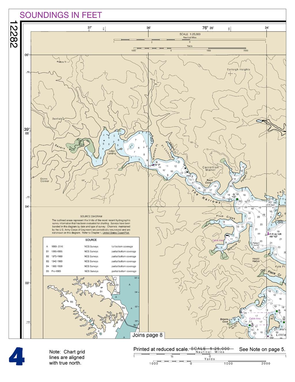
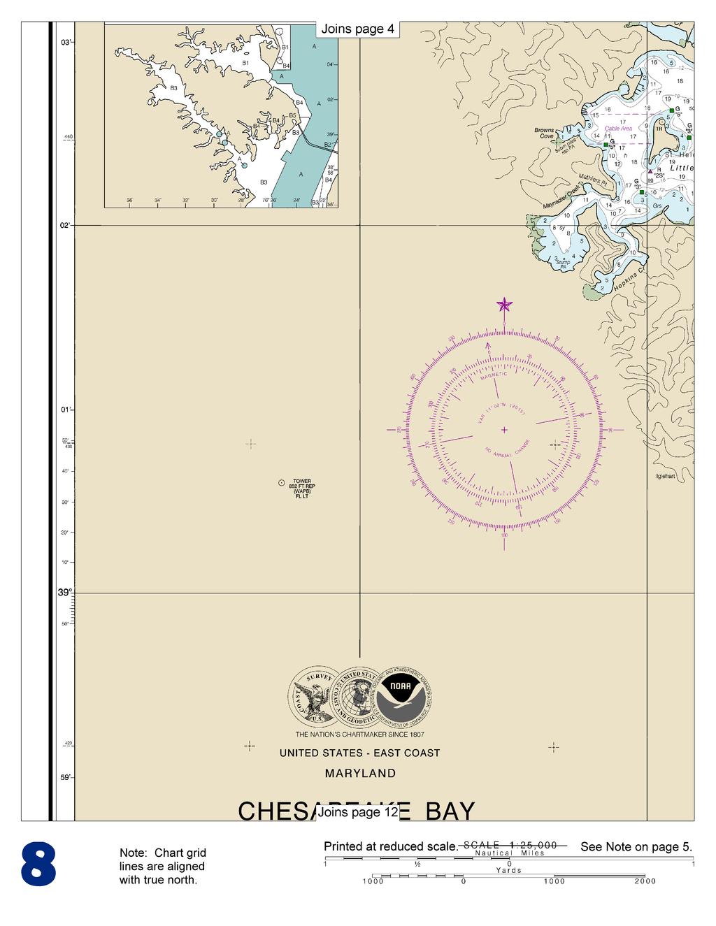
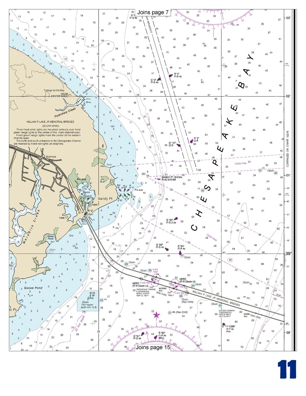
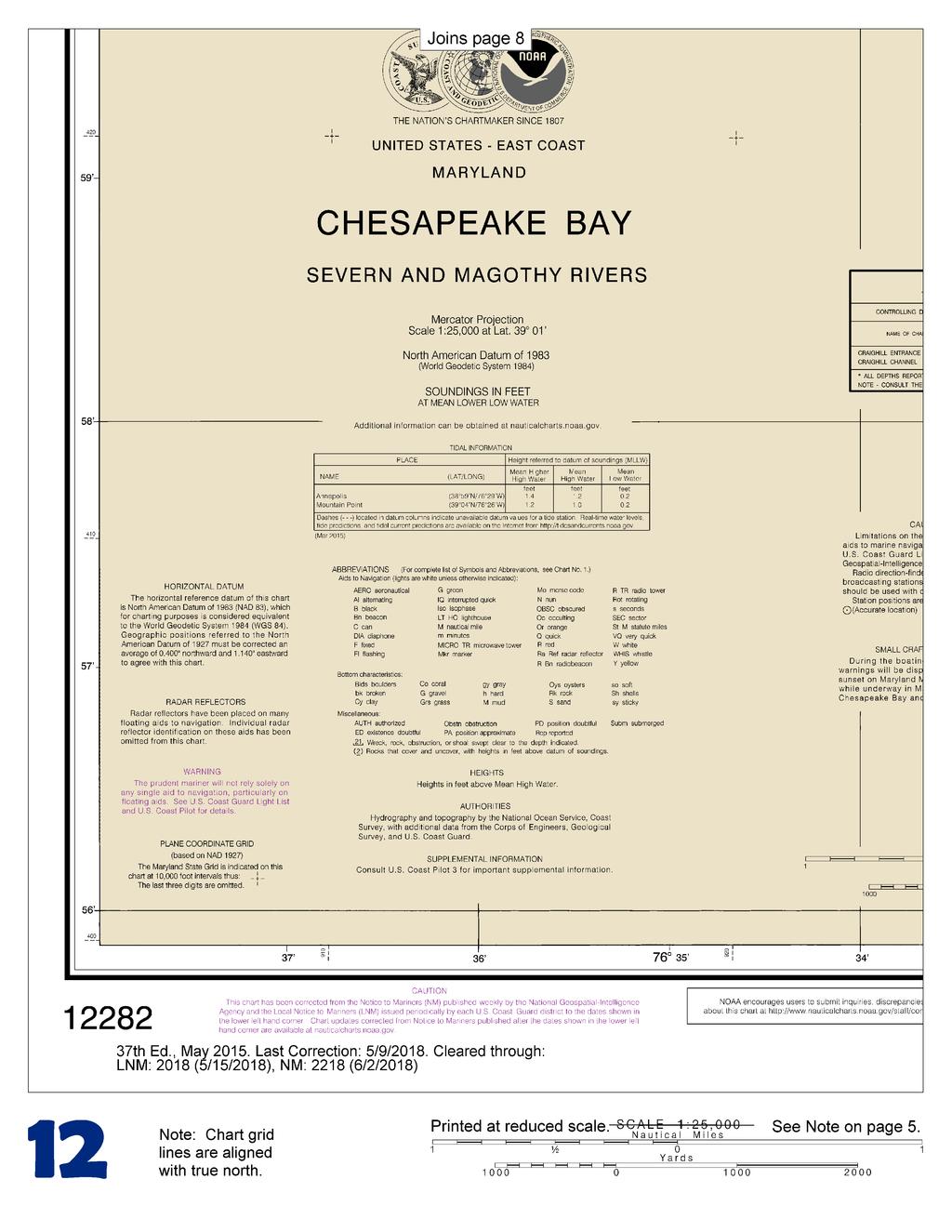
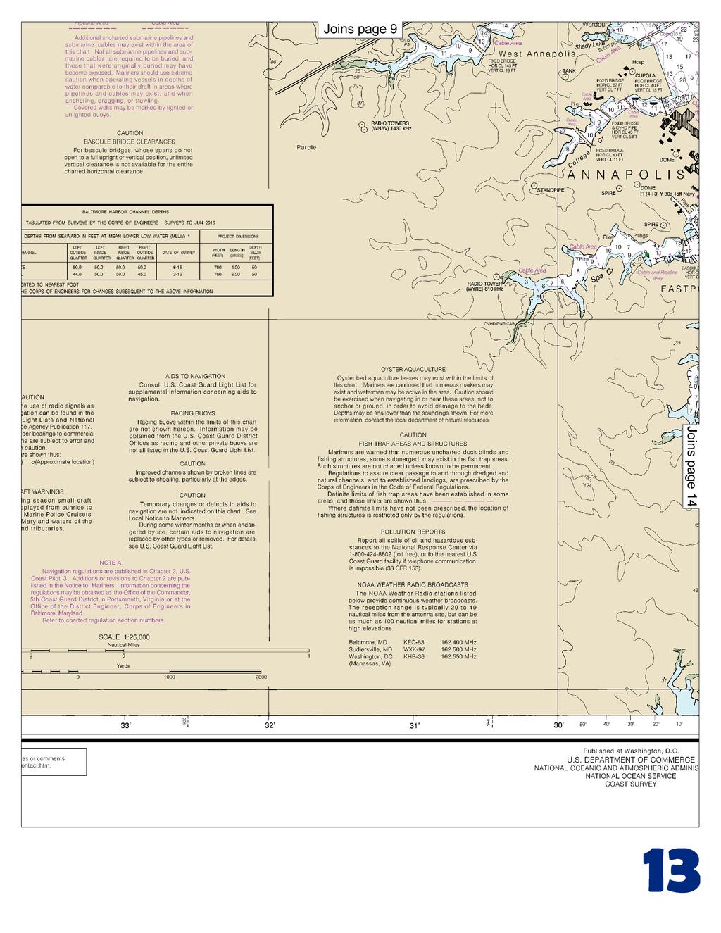
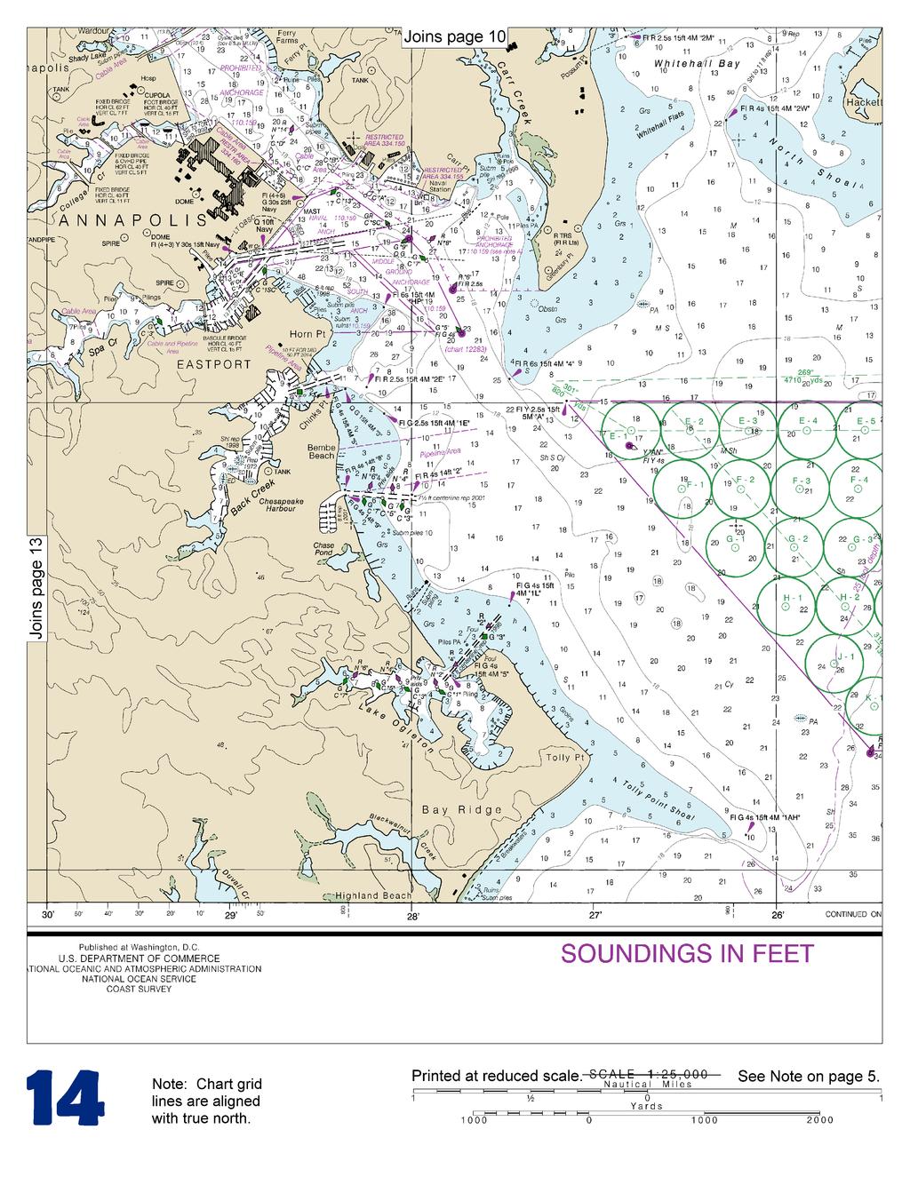
1 BookletChart Chesapeake Bay Severn and Magothy Rivers NOAA Chart A reduced-scale NOAA nautical chart for small boaters When possible, use the full-size NOAA chart for navigation.

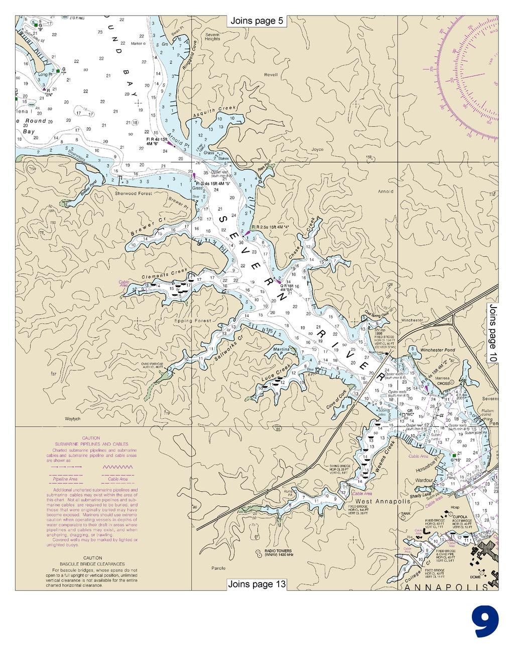
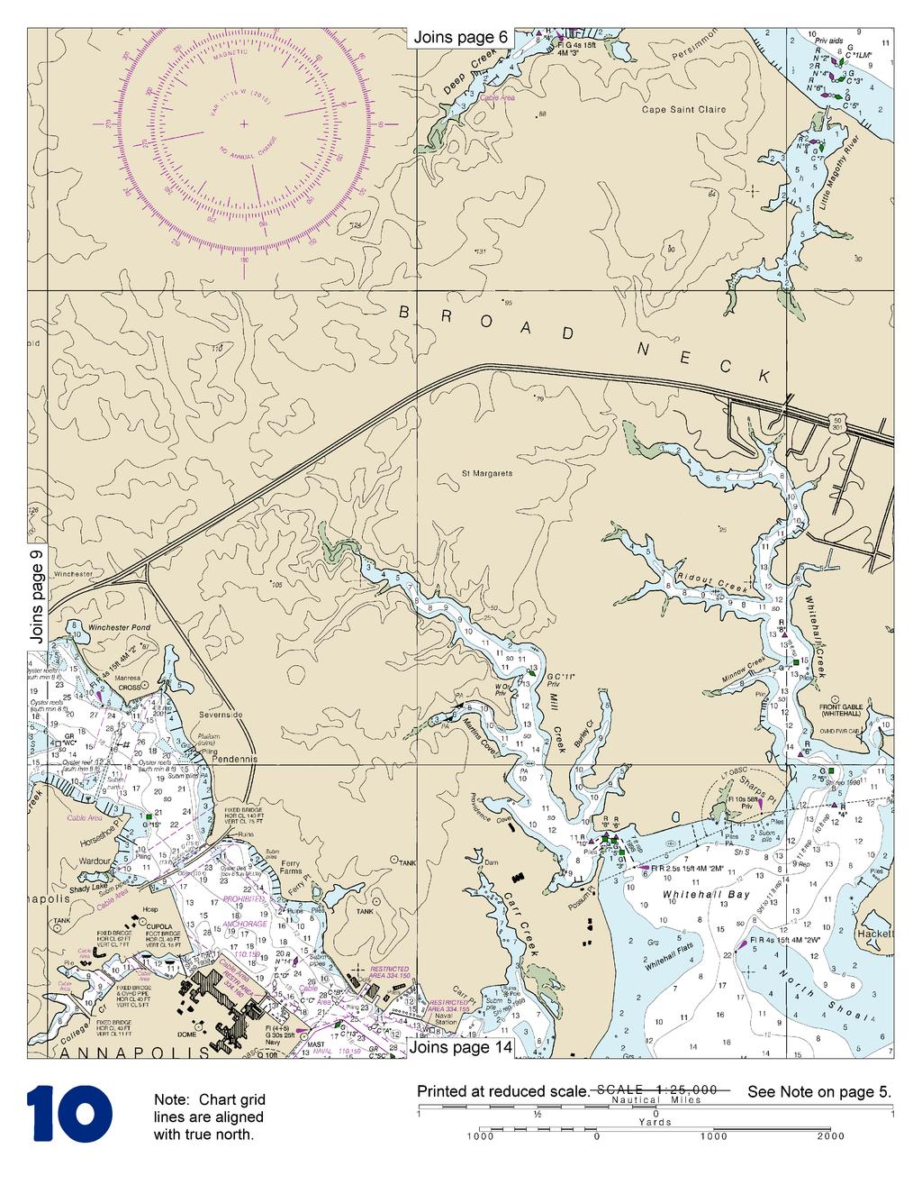
2 Published by the National Oceanic and Atmospheric Administration National Ocean Service Office of Coast Survey NOAA What are Nautical Charts? Nautical charts are a fundamental tool of marine navigation. They show water depths, obstructions, buoys, other aids to navigation, and much more. The information is shown in a way that promotes safe and efficient navigation. Chart carriage is mandatory on the commercial ships that carry America s commerce. They are also used on every Navy and Coast Guard ship, fishing and passenger vessels, and are widely carried by recreational boaters. What is a BookletChart? This BookletChart is made to help recreational boaters locate themselves on the water. It has been reduced in scale for convenience, but otherwise contains all the information of the full-scale nautical chart. The bar scales have also been reduced, and are accurate when used to measure distances in this BookletChart. See the Note at the bottom of page 5 for the reduction in scale applied to this chart. Whenever possible, use the official, full scale NOAA nautical chart for navigation. Nautical chart sales agents are listed on the Internet at This BookletChart does NOT fulfill chart carriage requirements for regulated commercial vessels under Titles 33 and 44 of the Code of Federal Regulations. Notice to Mariners Correction Status This BookletChart has been updated for chart corrections published in the U.S. Coast Guard Local Notice to Mariners, the National Geospatial Intelligence Agency Weekly Notice to Mariners, and, where applicable, the Canadian Coast Guard Notice to Mariners. Additional chart corrections have been made by NOAA in advance of their publication in a Notice to Mariners. The last Notices to Mariners applied to this chart are listed in the Note at the bottom of page 7. Coast Pilot excerpts are not being corrected. For latest Coast Pilot excerpt visit the Office of Coast Survey website at (Selected Excerpts from Coast Pilot) Severn River, the approach to Annapolis, empties into Chesapeake Bay 127 miles above the Virginia Capes. Commercial traffic consists of tour boats, fishing and shell fishing craft. Naval craft and many pleasure craft use the river. The river has main channel depths of 17 feet or more from the entrance to Annapolis, thence 15 feet or more for 8 miles, thence 11 to 7 feet for 2 miles to within 1 mile of the head. The channel is well marked as far as Annapolis, above which it is marked at the critical points and is easy to follow. Tides and currents. The tide is greatly influenced by winds. The current velocity seldom exceeds 0.5 knot. Ice rarely interferes with navigation except in severe winters, and then only for a short time. The Severn River Comprehensive Vessel Management Plan regulations established maximum speed limits for day and night operation of boats and minimum wake speed limits for the Severn River and its tributaries. These speed limits vary and are marked by white and orange regulatory markers. For more information contact Maryland Department of Natural Resources, Marine Police, Tawes State Office Building, Annapolis, MD 21401; telephone Weems Creek ( 'N., 'W.), on the southwest side of Severn River 3.2 miles above the mouth, has depths of 13 feet for 0.8 mile, thence 11 to 7 feet for 0.3 mile to near the head. A shoal extends 300 yards eastward from the point on the north side of the entrance, and is marked by a buoy. The highway bridge 0.5 mile above the entrance has a swing span with a width of 28 feet and a clearance of 8 feet. The fixed highway bridge about 500 feet above the drawbridge has a clearance of 28 feet. A private special purpose buoy at the mouth of Weems Creek marks a speed controlled area. U.S. Route 50/301 fixed highway bridge over Severn River, 3.5 miles above the mouth, has a clearance of 80 feet at the center span. Round Bay, an expansion of Severn River beginning 6 miles above the mouth and continuing for 2 miles, has depths of 17 to 23 feet and is traveled extensively by motorboats. Little Round Bay, west of Round Bay, has depths of 17 to 19 feet, and is marked by daybeacons. Depths of 4 feet can be carried to a boatyard in Browns Cove, behind St. Helena Island. Berths, electricity, gasoline, diesel fuel, water, ice, launching ramp, pump-out station, storage and some marine supplies can be obtained. A 35-ton lift is available for hull and engine repairs. Forked Creek, on the north side of Severn River 9 miles above the mouth, has depths of 16 to 10 feet for most of its 0.4 mile length. Marine services are on the creek with 4 to 6 feet available alongside. Berths, electricity, water, ice and a launching ramp are available. A marine railway can handle crafts to 50 feet; lift to 9 tons for hull and engine repairs. There is a small-boat basin on the east side of Severn River, 11 miles above the mouth. The controlling depth to the basin is about 3 feet. Whitehall Bay, on the west side of Chesapeake Bay, is between Greenbury Point ( 'N., 'W.) and Hackett Point, 1.5 miles to the northeastward. The bay has general depths of 13 to 6 feet. The entrance channel is about 300 yards wide between Whitehall Flats on the west and North Shoal on the east, both with depths of 3 to 4 feet; a light marks the western limit of North Shoal. A lighthouse at Sharps Point, on the west side of the entrance to Whitehall Creek Entrance Light 2W, provides a well-marked approach to the channel between North Shoal and Whitehall Flats. Mill Creek, which empties into the northwest corner of Whitehall Bay, is entered through a privately dredged entrance channel marked by a light and daybeacons; in 1998, the reported controlling depth was 7 feet. The depths above the dredged channel are 7 to 14 feet for 1.5 miles to near the head of the creek. Gasoline is available at a pier 0.7 mile above the entrance. Whitehall Creek, which empties into the northeast corner of Whitehall Bay, has depths of 9 to 13 feet for 1.5 miles, then shoals gradually to 1- foot at the head 0.5 mile farther up. The narrow, crooked entrance channel is marked by lights and daybeacons. In 1998, shoaling to 6 feet was reported in the channel between daybeacons 4 and 5. A 35-ton lift is available on the east side of the creek, 1 mile above the mouth. 2 U.S. Coast Guard Rescue Coordination Center 24 hour Regional Contact for Emergencies RCC Norfolk Commander 5th CG District (575) Norfolk, VA


3 Navigation Managers Area of Responsibility Northwest and Pacific Islands Crescent Moegling Great Lakes Region Tom Loeper Northeast Lt. Meghan McGovern Chesapeake and Delaware Bay Steve Soherr California Jeff Ferguson Mid-Atlantic Lt. Ryan Wartick Alaska Lt. Timothy M. Smith Western Gulf Coast Alan Bunn Central Gulf Coast Tim Osborn South Florida Puerto Rico U.S. Virgin Islands Michael Henderson Southeast Kyle Ward NOAA s navigation managers serve as ambassadors to the maritime community. They help identify navigational challenges facing professional and recreational mariners, and provide NOAA resources and information for safe navigation. For additional information, please visit nauticalcharts.noaa.gov/service/navmanagers To make suggestions or ask questions online, go to nauticalcharts.noaa.gov/inquiry. To report a chart discrepancy, please use ocsdata.ncd.noaa.gov/idrs/discrepancy.aspx. Lateral System As Seen Entering From Seaward on navigable waters except Western Rivers PORT SIDE ODD NUMBERED AIDS PREFERRED CHANNEL NO NUMBERS MAY BE LETTERED PREFERRED CHANNEL NO NUMBERS MAY BE LETTERED STARBOARD SIDE EVEN NUMBERED AIDS PREFERRED CHANNEL TO PREFERRED CHANNEL GREEN LIGHT ONLY FLASHING (2) STARBOARD TOPMOST BAND GREEN TO PORT TOPMOST BAND RED RED LIGHT ONLY FLASHING (2) FLASHING FLASHING OCCULTING GREEN LIGHT ONLY RED LIGHT ONLY OCCULTING QUICK FLASHING QUICK FLASHING ISO COMPOSITE GROUP FLASHING (2+1) COMPOSITE GROUP FLASHING (2+1) ISO 1 LIGHT "1" Fl G 6s LIGHTED BUOY G "9" Fl G 4s GR "A" Fl (2+1) G 6s RG "B" Fl (2+1) R 6s 2 LIGHT "2" Fl R 6s 8 LIGHTED BUOY R "8" Fl R 4s G C "1" 5 G "5" U GR "U" GR C "S" C RG N "C" G RG "G" 6 R N "6" 2 R "2 " CAN DAYBEACON CAN NUN NUN DAYBEACON For more information on aids to navigation, including those on Western Rivers, please consult the latest USCG Light List for your area. These volumes are available online at
4

5 1 7

6
7
8
9
10
11
12
13
14
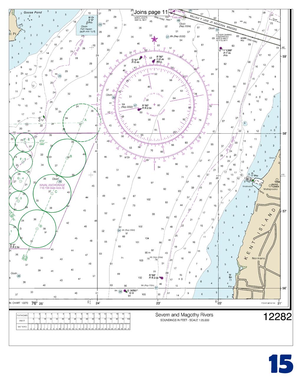
15


16 VHF Marine Radio channels for use on the waterways: Channel 6 Inter-ship safety communications. Channel 9 Communications between boats and ship-to-coast. Channel 13 Navigation purposes at bridges, locks, and harbors. EMERGENCY INFORMATION Channel 16 Emergency, distress and safety calls to Coast Guard and others, and to initiate calls to other vessels. Contact the other vessel, agree to another channel, and then switch. Channel 22A Calls between the Coast Guard and the public. Severe weather warnings, hazards to navigation and safety warnings are broadcast here. Channels 68, 69, 71, 72 and 78A Recreational boat channels. Getting and Giving Help Signal other boaters using visual distress signals (flares, orange flag, lights, arm signals); whistles; horns; and on your VHF radio. You are required by law to help boaters in trouble. Respond to distress signals, but do not endanger yourself. Distress Call Procedures Make sure radio is on. Select Channel 16. Press/Hold the transmit button. Clearly say: MAYDAY, MAYDAY, MAYDAY. Also give: Vessel Name and/or Description; Position and/or Location; Nature of Emergency; Number of People on Board. Release transmit button. Wait for 10 seconds If no response Repeat MAYDAY call. HAVE ALL PERSONS PUT ON LIFE JACKETS! NOAA Weather Radio All Hazards (NWR) is a nationwide network of radio stations broadcasting continuous weather information directly from the nearest National Weather Service office. NWR broadcasts official Weather Service warnings, watches, forecasts and other hazard information 24 hours a day, 7 days a week. Quick References Nautical chart related products and information - Interactive chart catalog - Report a chart discrepancy - Chart and chart related inquiries and comments - Chart updates (LNM and NM corrections) - QR Coast Pilot online - Tides and Currents - Marine Forecasts - National Data Buoy Center - NowCoast web portal for coastal conditions - National Weather Service - National Hurrican Center - Pacific Tsunami Warning Center - Contact Us - For the latest news from Coast Survey, This Booklet chart has been designed for duplex printing (printed on front and back of one sheet). If a duplex option is not available on your printer, you may print each sheet and arrange them back-to-back to allow for the proper layout when viewing. NOAA s Office of Coast Survey The Nation s Chartmaker
BookletChart. Entrance to San Francisco Bay NOAA Chart A reduced-scale NOAA nautical chart for small boaters
 BookletChart Entrance to San Francisco Bay NOAA Chart 18649 A reduced-scale NOAA nautical chart for small boaters When possible, use the full-size NOAA chart for navigation. Included Area Published by
BookletChart. Intracoastal Waterway Matecumbe to Grassy Key NOAA Chart A reduced-scale NOAA nautical chart for small boaters
 BookletChart Intracoastal Waterway Matecumbe to Grassy Key NOAA Chart 11449 A reduced-scale NOAA nautical chart for small boaters When possible, use the full-size NOAA chart for navigation. Published by
BookletChart. Sand Key to Rebecca Shoal NOAA Chart A reduced-scale NOAA nautical chart for small boaters
 BookletChart Sand Key to Rebecca Shoal NOAA Chart 11439 A reduced-scale NOAA nautical chart for small boaters When possible, use the full-size NOAA chart for navigation. Published by the National Oceanic
BookletChart. Chesapeake Bay Tangier Sound, Northern Part NOAA Chart A reduced-scale NOAA nautical chart for small boaters
 BookletChart Chesapeake Bay Tangier Sound, Northern Part NOAA Chart 12231 A reduced-scale NOAA nautical chart for small boaters When possible, use the full-size NOAA chart for navigation. Published by
SECTION II NM 11/13 NAVIGATION PUBLICATIONS COAST PILOT CORRECTIONS. Chapter 4 Paragraphs 85 to 86; read: (85)
") NAVIGATION PUBLICATIONS COAST PILOT CORRECTIONS COAST PILOT 1 42 Ed 2012 Change No. 13 LAST NM 9/13 Chapter 4 Paragraph 9; read: (9) Round Rock, which uncovers, and The Boring Stone, 3 feet high and bare,
NAVIGATION PUBLICATIONS COAST PILOT CORRECTIONS COAST PILOT 1 42 Ed 2012 Change No. 13 LAST NM 9/13 Chapter 4 Paragraph 9; read: (9) Round Rock, which uncovers, and The Boring Stone, 3 feet high and bare,
Wexford Harbour. Yachting Guide. Navigation
 Wexford Harbour Yachting Guide Navigation This document supersedes all previous editions. Approvals: Yacht Club Committee April, 2015 Wexford Board of Directors April, 2015 # Date Section Revision 1 6.5.2015
SECTION XI - COAST PILOT UPDATING. 1. To acquire a general knowledge of the responsibilities of the Auxiliary in COAST PILOT UPDATING activities.
 SECTION XI - COAST PILOT UPDATING INTRODUCTION: The United States Coast Pilot published by the NOS-C&GS, is a series of volumes that supplement the navigational data shown on nautical charts. Sources for
Chart Features Maritime maps and Admiralty charts have these features:
 Introduction to Charts A chart or map of the area is an important safety item to carry on board. It allows the Master to obtain knowledge of the area to be travelled, and indicates the navigable channels
INTER CLUB SERIES SAILING INSTRUCTIONS
 INTER CLUB SERIES - 2011 SAILING INSTRUCTIONS 1. RULES The regatta will be governed by the Racing Rules of Sailing (RRS), 2009-2012 including the January 2010 amendments, the prescriptions of U.S. Sailing
 Page 1 of 6 Nav-Aid Basics Unlike the roads and highways that we drive on, the waterways we go boating on do not have road signs that tell us our location, the route or distance to a destination, or of
U. S. Coast Guard Sector Boston Merrimack River Approach and Entrance, MA. Waterways Management Survey
 U. S. Coast Guard Sector Boston Merrimack River Approach and Entrance, MA. Waterways Management Survey The Waterways Analysis and Management Survey (WAMS) process is an essential component of both the
The LA/LB Harbors handle more than 5,500 commercial vessel arrivals per year (excluding local coastwise and Catalina Island traffic).
.") X. SMALL CRAFT For the purpose of the Los Angeles and Long Beach Harbor Safety Plan, pleasure vessels, commercial fishing vessels and sportfishing boats are designated as small craft. A. BACKGROUND: The
X. SMALL CRAFT For the purpose of the Los Angeles and Long Beach Harbor Safety Plan, pleasure vessels, commercial fishing vessels and sportfishing boats are designated as small craft. A. BACKGROUND: The
Mr. Barry Dragon, March 16, 2015 Commander, Seventh Coast Guard District (dob) Brickell Plaza 909 S.E. 1st Ave. Miami, FL
 Brickell Plaza 909 S.E. 1st Ave. Miami, FL") Mr. Barry Dragon, March 16, 2015 Commander, Seventh Coast Guard District (dob) Brickell Plaza 909 S.E. 1st Ave. Miami, FL 33130-3050 Commander, On behalf of the Florida Council of Yacht Clubs representing
Mr. Barry Dragon, March 16, 2015 Commander, Seventh Coast Guard District (dob) Brickell Plaza 909 S.E. 1st Ave. Miami, FL 33130-3050 Commander, On behalf of the Florida Council of Yacht Clubs representing
2 Boating Rules and Regulations... 73
 Contents at a Glance Chapter 1 Boat Design and Construction Chapter 2 Boating Rules and Regulations Chapter 3 Navigation Rules (ColRegs) Chapter 4 Boat Operating and Seamanship Chapter 5 Piloting and Navigation
REGION B ONLY. Figure Figure Figure Figure Figure Figure Figure Figure 10.60
 221 REGION B ONLY 10.5 LATERAL MARKS 10.5.1 Description of Lateral marks Port hand marks Shape: pillar buoy (Figures 10.53 and 10.54), can lighted buoy (Figures 10.55 and 10.56) or not lighted (Figures
AID VERIFIER QUIZ. 1. How often is the Light List published? a. One a year b. Twice a year c. Every Month d. Quarterly
 Qualification as an Aid Verifier in the Auxiliary presumes a knowledge of navigational aids above that of the ordinary member. Questions on the subject may be directed to the AV as he/she is considered
U.S. Aids To Navigation System Brochure U.S. Coast Guard, Office of Aids to Navigation (202) ,
 ,") AIDS TO NAVIGATION Learning Objectives: As a result of this session the participant should: Understand the principal buoyage systems in the United States. Become aware of the characteristics of the buoy
AIDS TO NAVIGATION Learning Objectives: As a result of this session the participant should: Understand the principal buoyage systems in the United States. Become aware of the characteristics of the buoy
An Introduction To Marine Charts
 An Introduction To Marine Charts //captnmike.com Revised August 29, 2011 An Illustrated introduction to U. S. Aids to Navigation in the Shilshole Bay area of Puget Sound, Washington. The chart symbols
LOCAL NOTICE TO MARINERS
 USCG Notice to Mariners 3/7/18 (View full Notice here) LNM 10/18 Coast Guard District 1: U.S. Department of Homeland Security United States Coast Guard LOCAL NOTICE TO MARINERS COASTAL WATERS FROM EASTPORT,
SAN DIEGO BAY PARADE OF LIGHTS 2017 SKIPPER'S INFO AND INSTRUCTIONS PLEASE READ ALL THE ENCLOSED INFORMATION AND FOLLOW INSTRUCTIONS.
 SAN DIEGO BAY PARADE OF LIGHTS 2017 SKIPPER'S INFO AND INSTRUCTIONS ***NOTICE THE CHANGE IN THE STARTING TIME*** PLEASE READ ALL THE ENCLOSED INFORMATION AND FOLLOW INSTRUCTIONS. QUESTIONS? Email: SDParadeOfLights@gmail.com
GENTLEMEN SIT or GENTLEMEN CLEAN THE HEAD
 GENTLEMEN SIT or GENTLEMEN CLEAN THE HEAD NOTE: Joker valve has a ¾ in opening. Because of this it is EASY to plug. If you did not eat it do not put it in the head. NEVER RELEASE THE WHEEL WHEN UNDERWAY
Visiting Lake Macquarie
 Visiting Lake Macquarie Lake Macquarie is the largest coastal salt water lake in Australia and is a prime boating destination for both small and large vessels. Many sailing regattas and fishing activities
U.S. Aids To Navigation System
 U.S. Aids To Navigation System Information provided by: United States Coast Guard, Office of Boating Safety (http://www.uscgboating.org/) AIDS TO NAVIGATION... ARE THE ROAD SIGNS OF THE WATERWAYS INTRODUCTION
SECTION II CORRECTIONS TO C. G. LIGHT LIST, VOLUME I ATLANTIC COAST, (4) Characteristic. (5) Height
 Characteristic. (5) Height") CORRECTIONS TO C. G. LIGHT LIST, VOLUME I ATLANTIC COAST, 2013 3531 Castine DeepC Wind North Anchor Lighted Buoy NE 3531 Castine DeepC Wind West Anchor Lighted Buoy W 3532 Castine DeepC Wind East Anchor
CORRECTIONS TO C. G. LIGHT LIST, VOLUME I ATLANTIC COAST, 2013 3531 Castine DeepC Wind North Anchor Lighted Buoy NE 3531 Castine DeepC Wind West Anchor Lighted Buoy W 3532 Castine DeepC Wind East Anchor
GULF OF MEXICO. 268 U.S. Coast Pilot 5, Chapter 6 04 AUG (see catalog for complete coverage) General Index of Chart Coverage in Chapter 6
 General Index of Chart Coverage in Chapter 6") 268 U.S. Coast Pilot 5, Chapter 6 04 AUG 2013 General Index of Chart Coverage in Chapter 6 (see catalog for complete coverage) 11406 11405 11404 11383 11384 11382 11388 11392 11391 11389 11390 11393 88
268 U.S. Coast Pilot 5, Chapter 6 04 AUG 2013 General Index of Chart Coverage in Chapter 6 (see catalog for complete coverage) 11406 11405 11404 11383 11384 11382 11388 11392 11391 11389 11390 11393 88
National Maritime Center
 National Maritime Center Providing Credentials to Mariners Q412 Navigation General-Near Coastal (Sample Examination) Page 1 of 14 Choose the best answer to the following Multiple Choice Questions. 1. Which
WELCOME TO THE. Pleasure Craft Operator Training (PCOC)
") WELCOME TO THE Pleasure Craft Operator Training (PCOC) REGULATIONS The Competency of Operators of Pleasure Craft Regulations require operators of pleasure craft fitted with a motor and used for recreational
WELCOME TO THE Pleasure Craft Operator Training (PCOC) REGULATIONS The Competency of Operators of Pleasure Craft Regulations require operators of pleasure craft fitted with a motor and used for recreational
Emergency Action Plans: What you need to know. Joel Labuzetta Annapolis Yacht Club Sailing Director
 Emergency Action Plans: What you need to know Joel Labuzetta Annapolis Yacht Club Sailing Director jlabuzetta@annapolisyc.org AYC SAFETY PLAN & EMERGENCY ACTION PLAN Your Emergency Action Plan begins long
Chapter 8. Port hand buoy. Starboard hand buoy. Canadian Aids to Navigation System (CANS) 8.1 Introduction. 8.2 Lateral Buoys
 8.1 Introduction. 8.2 Lateral Buoys") Chapter 8 Canadian Aids to Navigation System (CANS) 8.1 Introduction Various buoys, beacons and signs are known as "Aids to Navigation" or "Navigation Aids". They are devices or systems external to the
Chapter 8 Canadian Aids to Navigation System (CANS) 8.1 Introduction Various buoys, beacons and signs are known as "Aids to Navigation" or "Navigation Aids". They are devices or systems external to the
SECTION II NM 26/10 NAVIGATION PUBLICATIONS ALMANACS CORRECTIONS
 NAVIGATION PUBLICATIONS ALMANACS CORRECTIONS NAUTICAL ALMANAC Ed 2011 NEW EDITION (NGA) 26/10 SAILING DIRECTIONS CORRECTIONS PUB 140 8 Ed 2010 NEW EDITION (NGA) 26/10 COAST PILOT CORRECTIONS COAST PILOT
National Maritime Center
 National Maritime Center Providing Credentials to Mariners (Sample Examination) Page 1 of 5 Choose the best answer to the following Multiple Choice Questions. 1. (The following questions are based on Chart
SECTION II CORRECTIONS TO C. G. LIGHT LIST, VOLUME I ATLANTIC COAST, (4) Characteristic. (5) Height. Fl G 4s 4 Green. Fl G 4s 4 Green.
 Characteristic. (5) Height. Fl G 4s 4 Green. Fl G 4s 4 Green.") CORRECTIONS TO C. G. LIGHT LIST, VOLUME I ATLANTIC COAST, 2010 742 Fishing Grounds Obstruction Shoal Buoy 6 40 25 25 N 73 52 20 W Red. * 745 New York Bight Dumping Ground Lighted Buoy 3 4555 Two Bush Ledge
CORRECTIONS TO C. G. LIGHT LIST, VOLUME I ATLANTIC COAST, 2010 742 Fishing Grounds Obstruction Shoal Buoy 6 40 25 25 N 73 52 20 W Red. * 745 New York Bight Dumping Ground Lighted Buoy 3 4555 Two Bush Ledge
General Boating Knowledge. Common Sense before leaving shore
 General Boating Knowledge Common Sense before leaving shore Engines work, battery charged, hull, tires, drain plug, etc Safety equipment example - Life jackets fit correctly for everyone on board Safety
LOCAL NOTICE TO MARINERS
 USCG Notice to Mariners 3/26/15 (View full Notice here) LNM 12/15 Coast Guard District 1 : U.S. Department of Homeland Security United States Coast Guard LOCAL NOTICE TO MARINERS COASTAL WATERS FROM EASTPORT,
CHAPTER 260. (House Bill 964) Atlantic Coastal Bays Dredging for Oysters and Clams Prohibition
 Atlantic Coastal Bays Dredging for Oysters and Clams Prohibition") MARTIN O MALLEY, Governor Ch. 260 CHAPTER 260 (House Bill 964) AN ACT concerning Atlantic Coastal Bays Dredging for Oysters and Clams Prohibition FOR the purpose of prohibiting the use of dredging to catch
MARTIN O MALLEY, Governor Ch. 260 CHAPTER 260 (House Bill 964) AN ACT concerning Atlantic Coastal Bays Dredging for Oysters and Clams Prohibition FOR the purpose of prohibiting the use of dredging to catch
MAC Transit Advisories as of April 30, 2018
 MAC Transit Advisories as of April 30, 2018 The Mariners Advisory Committee for the Bay and River Delaware was established in October 1964. Its members and associate members are mainly comprised of master
Personal Watercraft Required Onboard Equipment, etc. for Virginia & North Carolina
 Personal Watercraft Required Onboard Equipment, etc. for Virginia & North Carolina February 19, 2013 ITEM VA PWCs NC PWCs REQUIRED Vessel Registration Req'd 1 Req'd 21 Registration Decal Req'd 2 Req'd
What You Need to Know About the Markers on the Water
 What You Need to Know About the Markers on the Water A Handy Guide from the United States Coast Guard 1 STOP Read This Booklet. AIDS TO NAVIGATION ARE THE WATERWAYS ROAD SIGNS Introduction Aids to Navigation
Berkeley Island Marine Pre-Rental Instructions. If you do not have a
 Berkeley Island Marine Pre-Rental Instructions. If you do not have a safe boating certificate or a boat license in the state of NJ, or an equivalent in another state, you must take this instruction. Approximate
National Maritime Center
 National Maritime Center Providing Credentials to Mariners Able Seaman Unlimited, Limited, Special, Special OSV, Sail, Fishing Industry (Sample Examination) Page 1 of 17 Choose the best answer to the following
Okeechobee Waterway Speed Restrictions
 Okeechobee Waterway Speed Restrictions Rulemaking Authority 327.46 FS. Law Implemented 327.46 FS. History New 9-18-88, Amended 12-7-89, Formerly 16N-24.010, Amended 10-1- 96, Formerly 62N-24.010, Amended
UNOFFICIAL COPY OF HOUSE BILL 853 CHAPTER
 UNOFFICIAL COPY OF HOUSE BILL 853 M2 6lr1662 By: Delegates Bozman, Cane, V. Clagett, Conway, and Hixson Introduced and read first time: February 8, 2006 Assigned to: Environmental Matters Committee Report:
2005 ABC. Chapter 3 Part 2. Navigating with ATON's. Revision to D-13 Local Notes. Instructor Notes for Mike Brough. Mike Brough
 2005 ABC Chapter 3 Part 2 Navigating with ATON's Revision to D-13 Local Notes Instructor Notes for Mike Brough Mike Brough June 24 2008 June 24 2008 Slide 1 June 24 2008 New graphics Navigating on Water
Coast Pilot Manual (8th) Edition. U.S. Department of Commerce Gary F. Locke, Secretary
 Edition. U.S. Department of Commerce Gary F. Locke, Secretary") Coast Pilot Manual 2010 (8th) Edition U.S. Department of Commerce Gary F. Locke, Secretary National Oceanic and Atmospheric Administration (NOAA) Jane Lubchenco, Ph.D., Under Secretary of Commerce for
Coast Pilot Manual 2010 (8th) Edition U.S. Department of Commerce Gary F. Locke, Secretary National Oceanic and Atmospheric Administration (NOAA) Jane Lubchenco, Ph.D., Under Secretary of Commerce for
Plot the Path into the Harbor
 Plot the Path into the Harbor By Mary Anne Otten, Rudyard Area Schools and Joan Chadde, Michigan Technological University Subject/Grade: Grade 3 6, Math, Social Studies, Science Duration: 35 minutes Lesson
Dive Operations Plan for Personal Submersibles. Revision
 Dive Operations Plan for Personal Submersibles Revision 2011.1 1 Table of Contents 1 EVENT...3 1.1 Summary of planned dive...3 1.1.1 PSUBS Guidelines...3 1.1.2 Maximum dive depth planned...3 1.1.3 Number
Plot the Path. Mary Anne Otten. lesson three
 Plot the Path Mary Anne Otten lesson three Subject/Grade: Grade 2, Math, Social Studies, Science Duration: one class period Materials needed: Per class: Day the Great Lakes Drained Away by Charles Ferguson
Delaware River Vessel Reporting System Mariners Advisory Committee For
 Delaware River Vessel Reporting System Mariners Advisory Committee For the Bay and River Delaware The Mariner's Advisory Committee is comprised of Master Mariners, River Pilots, and concerns itself with
57 TH MBYC BOOMERANG NAVIGATION CONTEST MARCH 2,3,& COURSE DESCRIPTION AND RULES
 57 TH MBYC BOOMERANG NAVIGATION CONTEST MARCH 2,3,&4 2018 COURSE DESCRIPTION AND RULES Please see instructions to sign up for the event, dinner, etc. in a separate communication. Questions? Contact Paul
FILED 12/04/2017 3:00 PM ARCHIVES DIVISION SECRETARY OF STATE
 OFFICE OF THE SECRETARY OF STATE DENNIS RICHARDSON SECRETARY OF STATE LESLIE CUMMINGS DEPUTY SECRETARY OF STATE PERMANENT ADMINISTRATIVE ORDER OSMB 4-2017 CHAPTER 250 OREGON STATE MARINE BOARD ARCHIVES
4 th Annual John Mclaughlin Memorial Regatta (JMMR) Notice of Race/GSI Amendment
 Notice of Race/GSI Amendment") 4 th Annual John Mclaughlin Memorial Regatta (JMMR) Notice of Race/GSI Amendment West River Sailing Club Saturday October Entry Due: Saturday June 24 th -Sunday June 25 th 2017 Entry Fee: $30.00 Online
4 th Annual John Mclaughlin Memorial Regatta (JMMR) Notice of Race/GSI Amendment West River Sailing Club Saturday October Entry Due: Saturday June 24 th -Sunday June 25 th 2017 Entry Fee: $30.00 Online
Nanaimo Ocean Swim and Newcastle SUP Race Safety Plan
 Nanaimo Ocean Swim and Newcastle SUP Race Safety Plan Use of this document Permission is granted to reproduce any information in this document; however, please notify the author (Matthew Lamb) if doing
SECTION II CORRECTIONS TO C. G. LIGHT LIST, VOLUME I ATLANTIC COAST, (4) Characteristic. (5) Height
 Characteristic. (5) Height") CORRECTIONS TO C. G. LIGHT LIST, VOLUME I ATLANTIC COAST, 2015 238 University of New Hampshire Lighted Research Wave Buoy 42-47-52.80N 70-10-04.80W FlY 20s Yellow. *Add Note: Aids maintained Apr. 15 to
CORRECTIONS TO C. G. LIGHT LIST, VOLUME I ATLANTIC COAST, 2015 238 University of New Hampshire Lighted Research Wave Buoy 42-47-52.80N 70-10-04.80W FlY 20s Yellow. *Add Note: Aids maintained Apr. 15 to
Anchoring Is Important
 BCC Sailing Classes - Third Theory Anchoring Anchoring Is Important 1 The Anchor is your last resort. Anchoring Keep off a lee shore. Needs to be shaped (type of anchor) to bury in the type of bottom for
HARBOR INFRASTRUCTURE INVENTORIES Kenosha Harbor, Wisconsin
 HARBOR INFRASTRUCTURE INVENTORIES Kenosha Harbor, Wisconsin Harbor Location: Kenosha Harbor is on the west shore of Lake Michigan about 54 miles north of Chicago, Illinois. Authority: River & Harbor Acts
ATON KIT. (Federal Short Range Aids to Navigation)
") ATON KIT (Federal Short Range Aids to Navigation) Every member while underway on an authorized patrol should check every ATON Federal Short Range Aid to Navigation that they pass and report any observed
ATON KIT (Federal Short Range Aids to Navigation) Every member while underway on an authorized patrol should check every ATON Federal Short Range Aid to Navigation that they pass and report any observed
SECTION II CORRECTIONS TO C. G. LIGHT LIST, VOLUME I ATLANTIC COAST,
 CORRECTIONS TO C. G. LIGHT LIST, VOLUME I ATLANTIC COAST, 2011 *10450 360 MARBLEHEAD LIGHT 42-30-19.45N 70-50-01.47W 11760 - Channel Lighted Buoy 28 42-14-53.10N 70-57-43.11W 20410 Gavitt Point Outfall
National Maritime Center
 National Maritime Center Providing Credentials to Mariners Q301 Rules of the Road-Inland (Sample Examination) Page 1 of 19 Choose the best answer to the following Multiple Choice Questions. NO reference
OSAKA MARTIS USER MANUAL TABLE OF CONTENTS
 OSAKA MARTIS USER MANUAL TABLE OF CONTENTS Ⅰ Ⅱ Ⅲ INTRODUCTION OPERATIONAL CONCEPT OF "Osaka MARTIS" IMPORTANT NAVIGATIONAL RULES Ⅳ COMMUNICATION 1 VHF Channels 2 Language Ⅴ PRE-ENTRY REPORT AND POSITION
Wabbit Nationals August 5-7, 2018 Sport boat Invitational Multihull Invitational August 6-7, 2018
 Wabbit Nationals August 5-7, 2018 Sport boat Invitational Multihull Invitational August 6-7, 2018 SAILING INSTRUCTIONS Organizing Authority: Richmond Yacht Club, Point Richmond, California, USA 1 RULES
WELCOME TO THE MILLENNIUM RIBBLE LINK
 WELCOME TO THE MILLENNIUM RIBBLE LINK The prestigious 5.8m project to construct the Millennium Ribble Link opened in 2002. This is the first new navigation to be built in England since the Manchester Ship
MARATHON SAIL and POWER SQUADRON Women Making Waves
 MARATHON SAIL and POWER SQUADRON Women Making Waves www.marathonpowersquadron.org Gregory Absten, Cdr, Marathon Sail & Power Squadron Fleet Captain, Marathon Yacht Club MARATHON SAIL and POWER SQUADRON
Sailing Instructions SILVER GATE YACHT CLUB. CLIPPER RACE SATURDAY, JUNE 16, 2018 First warning 11:55 am. 1. Rules
 CLIPPER RACE SATURDAY, JUNE 16, 2018 First warning 11:55 am 1. Rules 1.1. The Race will be governed by the rules as defined in the Racing Rules of Sailing (RRS), including US Sailing Prescriptions, except
Aids to navigation can include buoys, day beacons, range markers, and lighthouses.
 This boating safety course manual has been approved by Transport Canada strictly on the basis that it meets the minimum requirements of basic boating safety knowledge set out in Transport Canada s Boating
National Maritime Center
 National Maritime Center Providing Credentials to Mariners (Sample Examination) Page 1 of 12 Choose the best answer to the following Multiple Choice Questions. 1. An alternating light. (A) shows a light
SS&S Chapter 8 Instructor Guide
 SS&S Chapter 8 Instructor Guide The Rules of the Nautical Road The PowerPoints (PPT) slides for this SS&S chapter were copied from the BS&S-13 th Ed PPT because they are identical. Only the chapter numbers
2 NOTICES TO COMPETITORS Notices to competitors will be posted on the official notice board of the host club and/or their websites.
 Pensacola Bay General Sailing Instructions Approved by Pensacola Bay Yacht Club Fleet Captains Approved for 2019 1 RULES 1.1 The regatta will be governed by the rules as defined in the Racing Rules of
THE GREAT VALLEJO RACE MAY 1 and 2, 2010 SAILING INSTRUCTIONS
 THE GREAT VALLEJO RACE MAY 1 and 2, 2010 SAILING INSTRUCTIONS Vallejo Yacht Club PO Box 311 Vallejo, California 94590 YRA of SF Bay Quarters 35 S, Fort Mason San Francisco, CA 94123 1.0 RULES: The races
A Short Course on Nautical Charts and Basic Plotting For the Recreational Boater
 A Short Course on Nautical Charts and Basic Plotting For the Recreational Boater Gary C. Kessler gck@garykessler.net http://www.garykessler.net/scuba Version 3.6 (12/26/2017) Gary C. Kessler, 2012-2017
ABC 3 SM Errata as of 15 July 2013
 ABC 3 SM Errata as of 15 July 2013 This errata is applicable unless otherwise indicated to the four printings of ABC3; 2008, 2010, 2012 and 2013. Section 1 Pg. 10, Para. 97 Change to read: Directed Thrust.
When answering a question, when in doubt, pick answer that considers safety first. Navigation Aids
 Appendix A Boat Course Review When answering a question, when in doubt, pick answer that considers safety first. Navigation Aids Port hand lateral buoy Starboard hand lateral buoy (red right returning)
New Syllabus for 12 Nautical Miles
 New Syllabus for 12 Nautical Miles 1. Legal and professional responsibilities of skippers under the Tourism Authority Act 2006. a) The meaning of Skipper as defined under the Tourism Authority Act 2006
TALL SHIPS CHALLENGE Atlantic Coast 2012 Race Two Greenport, New York to Chesapeake Bay Entrance Sailing Instructions
 TALL SHIPS CHALLENGE Atlantic Coast 2012 Race Two Greenport, New York to Chesapeake Bay Entrance Sailing Instructions 1. Description of Classes Eligible Vessels: All monohull sailing vessels with a minimum
Thames Passage From Brentford to Teddington
 Thames Passage From Brentford to Teddington Introduction: The Thames Ring route uses a tidal section of the river Thames between Brentford and Teddington that requires extra preparation and skill. We hope
Schedule of Events for Skippers Catalina Channel Crossing
 Schedule of Events for Skippers Catalina Channel Crossing Friday, September 8 MANDATORY Meeting for all Coaches and Skippers Pavilion A at Newport Dunes Newport Dunes Waterfront Resort & Marina 1131 Back
Frank Kern III Memorial Long Distance Race
 100 th ANNUAL BAYVIEW YACHT CLUB Frank Kern III Memorial Long Distance Race Saturday, September 15, 2018 Sailing Instructions 1. RULES - This Regatta shall be governed by the rules as defined in The Racing
2018 Annapolis Labor Day Regatta Co-Organizing Authority (OA): Annapolis Yacht Club and Eastport Yacht Club Annapolis, Maryland, USA
: Annapolis Yacht Club and Eastport Yacht Club Annapolis, Maryland, USA") 2018 Annapolis Labor Day Regatta Co-Organizing Authority (OA): Annapolis Yacht Club and Eastport Yacht Club Annapolis, Maryland, USA Website: http://eastportyc.org/aldr SAILING INSTRUCTIONS for the PURSUIT
2018 Annapolis Labor Day Regatta Co-Organizing Authority (OA): Annapolis Yacht Club and Eastport Yacht Club Annapolis, Maryland, USA Website: http://eastportyc.org/aldr SAILING INSTRUCTIONS for the PURSUIT
TICES TO MARINERS 1 TO 46 ANNUAL EDITION 2018 SECTION A AIDS TO NAVIGATION AND MARINE SAFETY
 A5 NAVIGATION SAFETY 10 Routeing of Ships 1 GENERAL 1.1 Rule 10 of the Collision Regulations applies to all ships navigating in or near a routeing system. 1.2 The information on ships' routeing in this
No JUNE 2017 UNITED STATES OF AMERICA. Contents
 23 10 JUNE 2017 UNITED STATES OF AMERICA Published Weekly by the National Geospatial-Intelligence Agency Prepared Jointly with the National Ocean Service and U.S. Coast Guard Contents Section I Chart Corrections............................................
WORKBOOK NAVIGATION Tr. For Power-driven and Sailing Vessels DAVID BURCH LARRY BRANDT
 Piloting Dead reckoning Special publications Lights and buoys Electronic fixes Chart reading and plotting Compass use Navigation Rules Tides and currents Depth sounding navigation STARPATH This book provides
***This summary does not include shad and herring net requirements.***
 South Carolina Department of Natural Resources Marine Resources Division Summary of Seine and Gill Net Laws (Saltwater) 2013-2014 This document should be kept on board all vessels using seines or gill
Ketchikan Harbors Thomas Basin and Bar Point Harbor
 Ketchikan Harbors Thomas Basin and Bar Point Harbor Condition of Improvements 30 December 2014 Thomas Basin & Bar Point Harbors Ketchikan, Alaska (CWIS No. 000631 & 087071) Authorization (1) Rivers and
ADANI PORTS & SEZ LTD. ++ MUNDRA PORT ++ GENERAL INFORMATION
 ADANI PORTS & SEZ LTD. ++ MUNDRA PORT ++ GENERAL INFORMATION LOCATION Mundra Port is all weather, independent, commercial port with geographical and hydrological advantages on the West Coast of India,
SECTION II CORRECTIONS TO C. G. LIGHT LIST, VOLUME I ATLANTIC COAST,
 CORRECTIONS TO C. G. LIGHT LIST, VOLUME I ATLANTIC COAST, 2016 2935 Horseshoe Ledge Daybeacon 2 44-19-22.26N 68-46-00.66W 2940 Horseshoe Cove Buoy 3 44-19-54.72N 68-46-07.50W 2945 Horseshoe Cove Daybeacon
Port of Port Elizabeth Information
 LOCATION Latitude 34º 01 S Longitude 25º 42 E PILOTAGE Pilotage is compulsory. Rendezvous point is 2.2 nautical miles NE of the port entrance on the leading lights. Pilot transfer is by pilot boat, unless
ROUND-THE-ISLAND RACE
 EDGARTOWN RACE WEEKEND ROUND-THE-ISLAND RACE July 30, 2016 The Edgartown Yacht Club is the Organizing Authority SAILING INSTRUCTIONS 1 RULES 1.1 The Round-the-Island Race will be governed by the rules
GUIDELINES FOR NAVIGATION UNDER THE CONFEDERATION BRIDGE
 (12/2009) GUIDELINES FOR NAVIGATION UNDER THE CONFEDERATION BRIDGE REVISION 1 DECEMBER 2009 Responsible Authority The Regional Director Marine Safety Atlantic Region is responsible for this document, including
National Maritime Center
 National Maritime Center Providing Credentials to Mariners (Sample Examination) Page 1 of 8 Choose the best answer to the following Multiple Choice Questions. 1. Assume that your vessel has just entered
NOTE: Joker valve is ¾ in size. Because of this it is EASY to plug. If you did not eat it do not put it in the head.
 NOTE: Joker valve is ¾ in size. Because of this it is EASY to plug. If you did not eat it do not put it in the head. Gentlemen Sit VHF RADIO INFORMATION CHANNEL FREQ. USE 09 156.450 Calling frequency.
National Report on Large Whale Entanglements
 National Report on Large Whale Entanglements Confirmed in the United States in 2017 In 2017, 76 confirmed cases of large whale entanglements were documented along the coasts of the United States. Seventy
Presentation Library for Inland ECDIS
 Edition 2.0 1.6.2006 Standard Electronic Chart Display and Information System for Inland Navigation Inland ECDIS for Inland ECDIS In addition to the IHO-S-52 Edition 2.0 IES 20-Section 3 PresLib.doc Page
RUM CHALLENGE. Notice of Race & Sailing Instructions Saturday, June 23, Eligibility: Any sailboat may race in the Rum Challenge Race.
 RUM CHALLENGE A Race for a Case of Rum Notice of Race & Sailing Instructions Saturday, June 23, 2018 Organizing Authority: Detroit Boat Club Eligibility: Any sailboat may race in the Rum Challenge Race.
EPA Vessel Safety during Response Operations
 EPA Vessel Safety during Response Operations EPA Vessel Safety Manual EPA employees who operate Class A vessels under 45 feet in length, shall conform to the minimum qualifications; 1) Approval by the
 7 The Guidelines of Measures for preventing Typhoon Disaster ( Objective ) Article1 The objective of this guideline is to establish steps necessary to implement the measures for preventing typhoon
2002 National Recreational Boating Survey Technical Report
 2002 Technical Report November 30, 2003 995 Goodale Blvd. Columbus, OH 43212 Voice: (614) 220-8860 Fax: (614) 220-8845 Toll Free Number: (800) 341-3660 Website: www.strategicresearchgroup.com TABLE OF
EBA Position Statement AIS Virtual Aids to Navigation
 EBA Position Statement AIS Virtual Aids to Navigation Document date: 17 October 2015 Latest update: 9 December 2015 Executive Summary The European Boating Association 1 (EBA) recognises the value of Automatic
THE SYLLABUS FOR WRITTEN EXAMINATION PILOT'S FOURTH CLASS LICENCE (TEES AND HARTLEPOOL) AND
 AND") PD TEESPORT CONSERVANCY DIVISION HARBOUR MASTER'S OFFICE THE SYLLABUS FOR WRITTEN EXAMINATION IN RESPECT OF A PILOT'S FOURTH CLASS LICENCE (TEES AND HARTLEPOOL) AND PILOTAGE EXEMPTION CERTIFICATE (Issued
PD TEESPORT CONSERVANCY DIVISION HARBOUR MASTER'S OFFICE THE SYLLABUS FOR WRITTEN EXAMINATION IN RESPECT OF A PILOT'S FOURTH CLASS LICENCE (TEES AND HARTLEPOOL) AND PILOTAGE EXEMPTION CERTIFICATE (Issued
HARBOR INFRASTRUCTURE INVENTORIES Lorain Harbor, Ohio
 HARBOR INFRASTRUCTURE INVENTORIES Lorain Harbor, Ohio Harbor Location: Lorain Harbor is located on the southern shore of Lake Erie in the city of Lorain, OH about 45 miles west of Cleveland, OH. Authority:
Boat Name. Hailing Port. Registration # MMSI # Misc:
 NSHSA USEFUL INFORMATION Boat Name Hailing Port Length Beam Draft Mast Height Electric Fuel Burn Rate Fuel Tank Capacity Water Tank Capacity Registration # MMSI # Misc: PASSPORT TO ADVENTURE THE PASSPORT
World Shipping Council. National Oceanographic and Atmospheric Administration
 Comments of the World Shipping Council Submitted to the National Oceanographic and Atmospheric Administration In the matter of Endangered and Threatened Species; Petition for Rulemaking to Establish a