BookletChart. Entrance to San Francisco Bay NOAA Chart A reduced-scale NOAA nautical chart for small boaters
|
|
|
- Chastity Snow
- 5 years ago
- Views:
Transcription


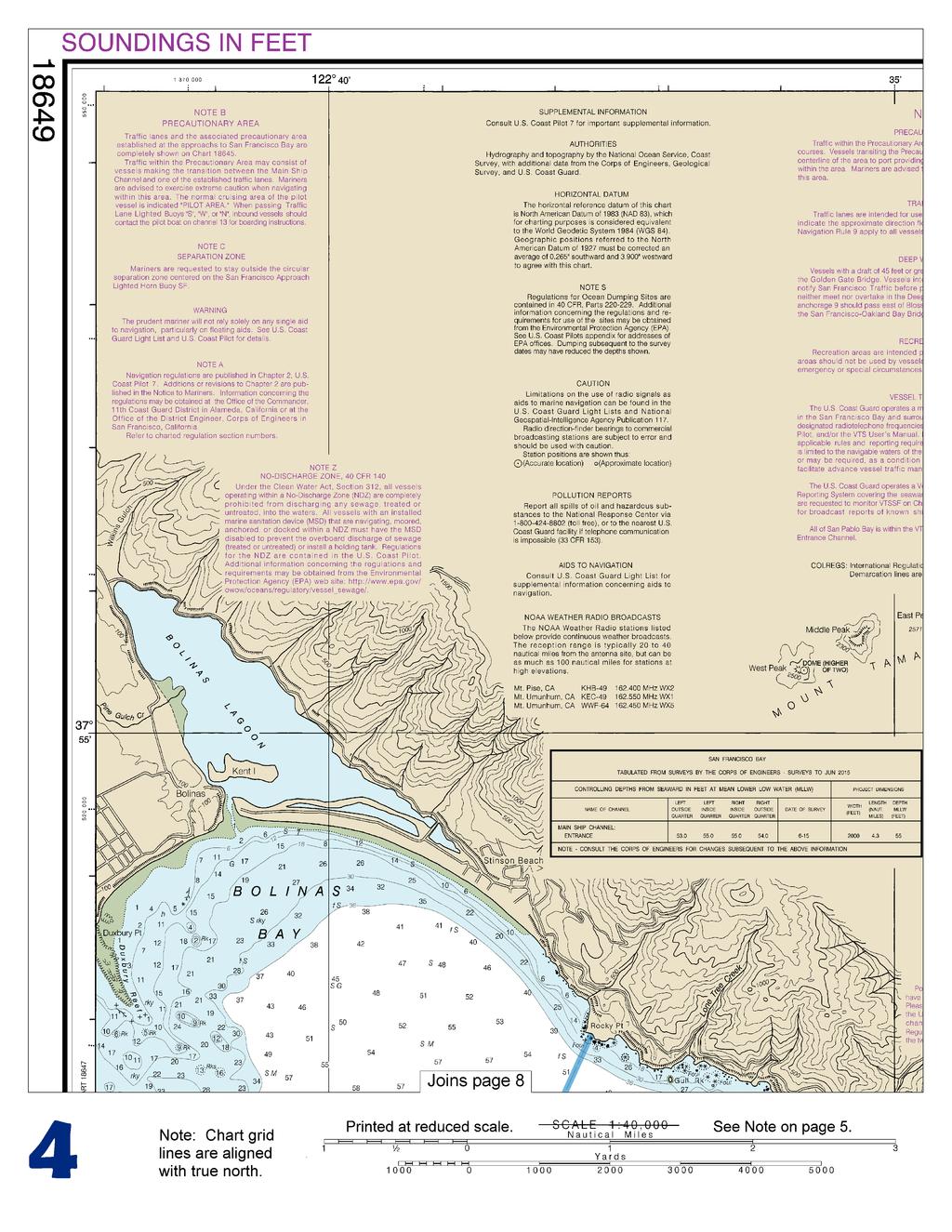
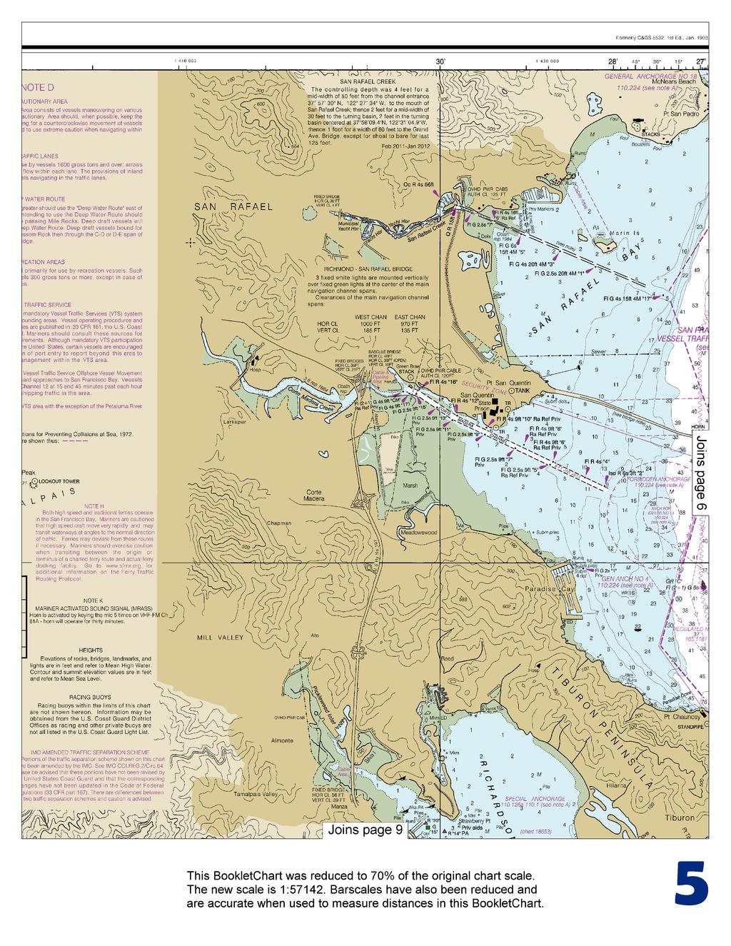
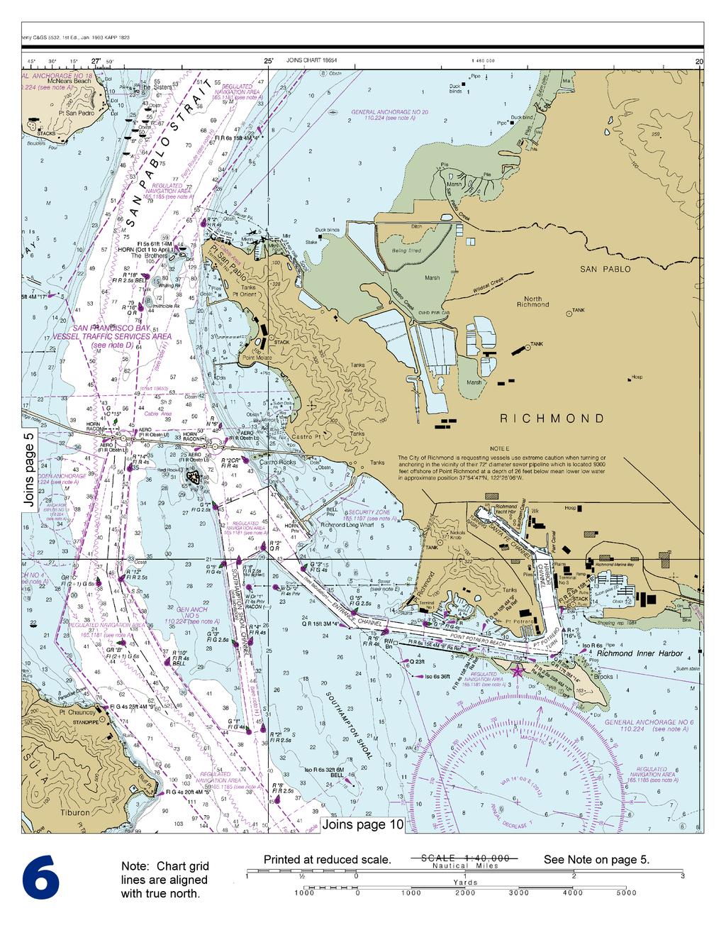
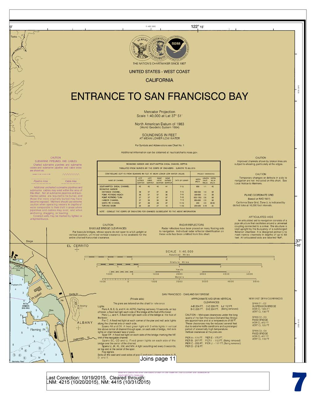
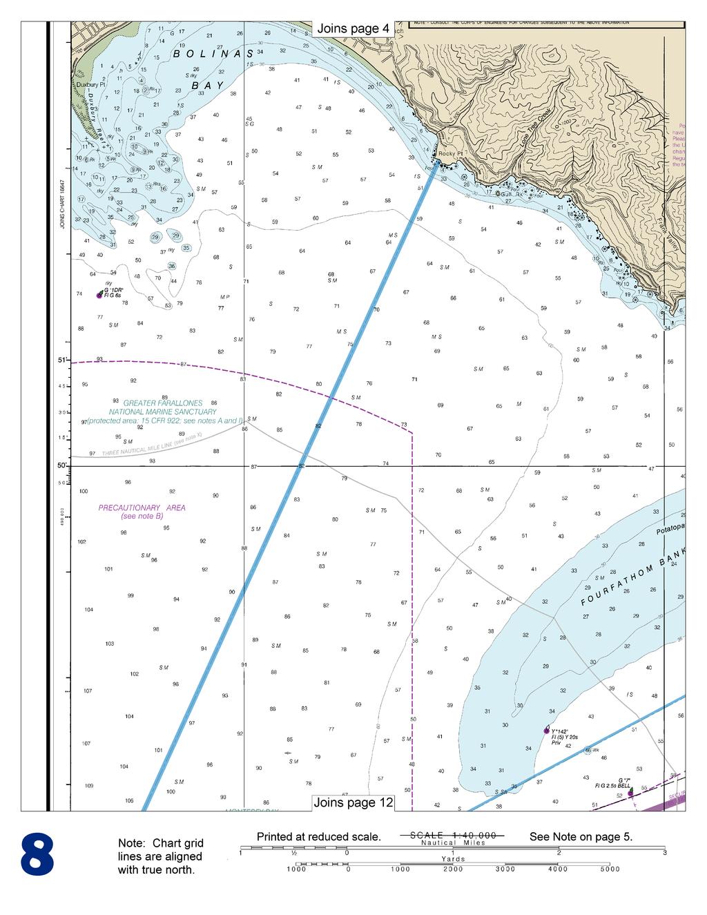
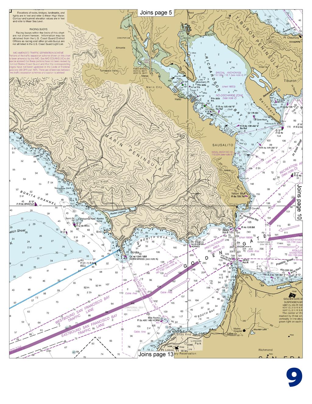
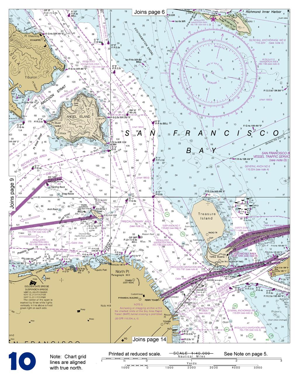
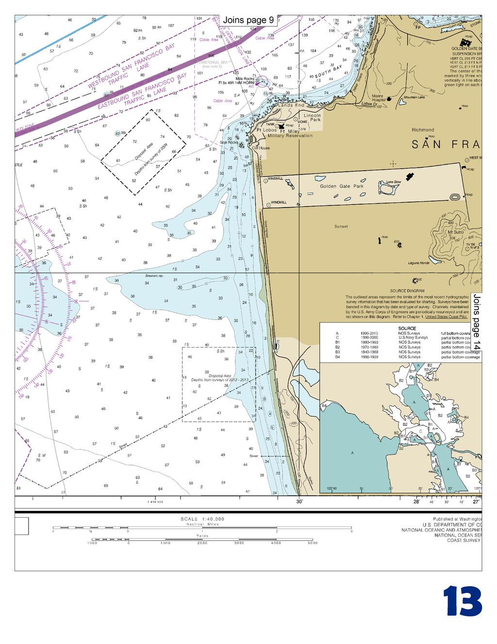
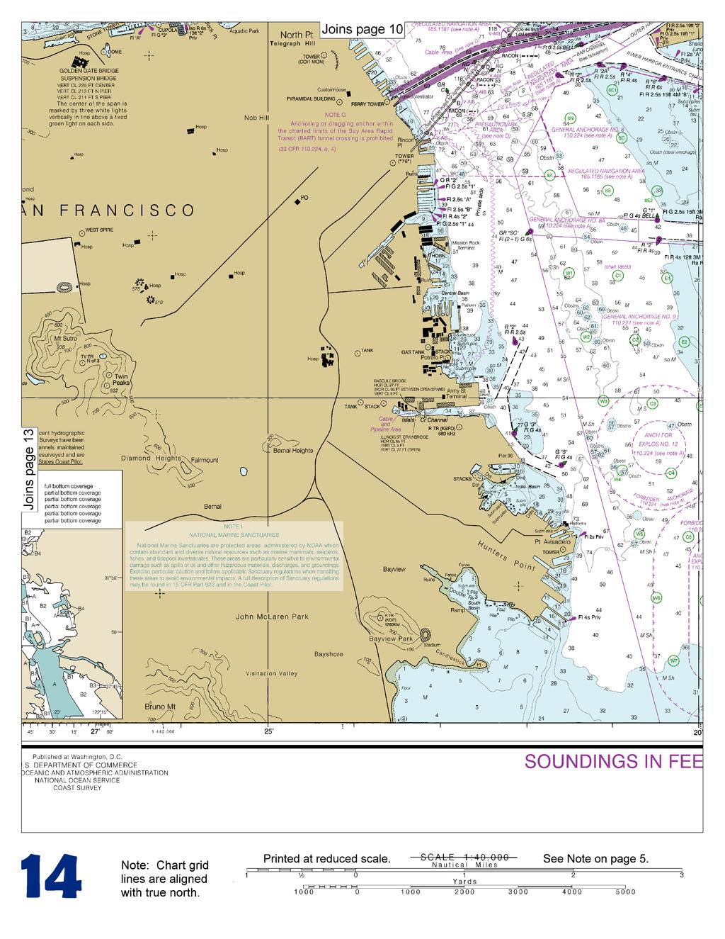
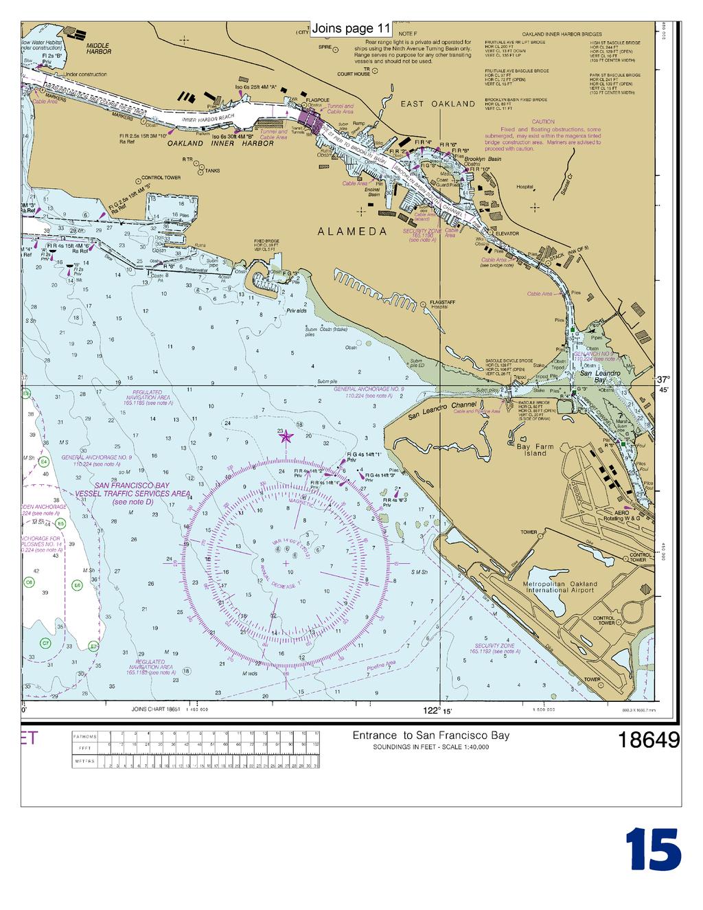
1 BookletChart Entrance to San Francisco Bay NOAA Chart A reduced-scale NOAA nautical chart for small boaters When possible, use the full-size NOAA chart for navigation. Included Area

2 Published by the National Oceanic and Atmospheric Administration National Ocean Service Office of Coast Survey NOAA What are Nautical Charts? Nautical charts are a fundamental tool of marine navigation. They show water depths, obstructions, buoys, other aids to navigation, and much more. The information is shown in a way that promotes safe and efficient navigation. Chart carriage is mandatory on the commercial ships that carry America s commerce. They are also used on every Navy and Coast Guard ship, fishing and passenger vessels, and are widely carried by recreational boaters. What is a BookletChart? This BookletChart is made to help recreational boaters locate themselves on the water. It has been reduced in scale for convenience, but otherwise contains all the information of the full-scale nautical chart. The bar scales have also been reduced, and are accurate when used to measure distances in this BookletChart. See the Note at the bottom of page 5 for the reduction in scale applied to this chart. Whenever possible, use the official, full scale NOAA nautical chart for navigation. Nautical chart sales agents are listed on the Internet at This BookletChart does NOT fulfill chart carriage requirements for regulated commercial vessels under Titles 33 and 44 of the Code of Federal Regulations. Notice to Mariners Correction Status This BookletChart has been updated for chart corrections published in the U.S. Coast Guard Local Notice to Mariners, the National Geospatial Intelligence Agency Weekly Notice to Mariners, and, where applicable, the Canadian Coast Guard Notice to Mariners. Additional chart corrections have been made by NOAA in advance of their publication in a Notice to Mariners. The last Notices to Mariners applied to this chart are listed in the Note at the bottom of page 7. Coast Pilot excerpts are not being corrected. For latest Coast Pilot excerpt visit the Office of Coast Survey website at of less than 3 feet. (Selected Excerpts from Coast Pilot) Bolinas Bay, E of Duxbury Point, is an open bight 3.5 miles wide between Duxbury Point and Rocky Point. The bay affords shelter in NW weather in 24 to 36 feet, sandy bottom. Care must be taken to avoid Duxbury Reef and the dangers extending up to 0.7 mile E of it. Bolinas Lagoon is separated from the bay by a narrow strip of sandy beach that is cut by a narrow shifting channel. The lagoon is shoal and entered only by small boats with local knowledge. The entrance has a depth Rocky Point is 100 feet high and shelving. Numerous detached rocks are within 200 yards of the cliffs on the S side of the point. Point Bonita, on the N side of the entrance to Golden Gate, is a sharp black cliff 100 feet high, increasing to 300 feet on its seaward face, 0.3 mile N. From NW it shows as three heads. Point Bonita Light (37 48'56"N., '46"W.), 124 feet above the water, is shown from a 33-foot white tower on the S head. A sound signal is at the light. Bonita Cove, E of Point Bonita, is occasionally used as an anchorage by small vessels. Anchorage is close under Point Bonita in about 36 feet. San Francisco Approach Lighted Whistle Buoy SF (37 45'00"N., '34"W.) is 9 miles WSW of San Francisco Bay entrance. The buoy is red and white and is equipped with a racon. San Francisco Bar, a semicircular shoal with depths less than 36 feet, is formed by silt deposits carried to the ocean by the Sacramento and San Joaquin River systems. The bar extends from 3 miles S of Point Lobos to within 0.5 mile of Point Bonita off the southern coast of Marin Peninsula; the extreme outer part is about 5 miles WSW of San Francisco Bay entrance. Potatopatch Shoal, the N part of the bar on Fourfathom Bank, has reported depths of less than 23 feet. The name is said to have originated from the fact that schooners from Bodega Bay frequently lost their deck load of potatoes while crossing the shoal. The S part of the bar has depths of 31 to 36 feet. Golden Gate, the passage between the ocean and San Francisco Bay, is 2 miles wide at the W end between Point Bonita and Point Lobos, but the channel is reduced in width to 1.5 miles by Mile Rocks and to less than 0.7 mile by the Golden Gate Bridge pier. Depths in the passage vary from 108 feet to over 300 feet. Warning. Very dangerous conditions develop over San Francisco Bar whenever large swells, generated by storms far out at sea, reach the coast. A natural condition called shoaling causes the large swells to be amplified and increase in height when they move over the shallow water shoals. This piling up of the water over the shoals is worsened during times when the tidal current is flowing out (ebbing) through the Golden Gate. Outbound tidal current is strongest about 4 hours after high water at the Golden Gate Bridge and attains a velocity in excess of 6 knots at times. The incoming large swells are met by outbound tidal current causing very rough and dangerous conditions over the bar. Steep waves to 20 or 25 feet have been reported in the area. Mariners should exercise extreme caution as the bar conditions may change considerably in a relatively short period of time. The most dangerous part of the San Francisco Bar is considered to be Fourfathom Bank. Bonita Channel, between the shoal and the Marin coast, can also become very dangerous during large swell conditions. The safest part of the bar is the Main Ship Channel through the center of the bar. But even that area can be extremely dangerous when the tidal current is ebbing. Caution. Vessels departing San Francisco Bay through Bonita Channel on the ebb current must use extreme caution when crossing the tide rip off Point Bonita. When the bow passes the rip the stern is thrown to port and, unless promptly met, the vessel will head straight for the rocks off the point. Vessels favoring Potatopatch Shoal too closely have reported a set toward it. Bonita Channel should not be used by large vessels. 2 U.S. Coast Guard Rescue Coordination Center 24 hour Regional Contact for Emergencies RCC Alameda Commander 11 th CG District (510) Alameda, CA
3 Navigation Managers Area of Responsibility Northwest and Pacific Islands Crescent Moegling Great Lakes Region Thomas Loeper Northeast Lt. Meghan McGovern Chesapeake and Delaware Bay Steve Soherr California Gerald Wheaton Mid-Atlantic Lt. Cmdr. Denise Gruccio Alaska Lt. Timothy M. Smith Western Gulf Coast Alan Bunn Central Gulf Coast Tim Osborn Southeast Kyle Ward South Florida Puerto Rico U.S. Virgin Islands Michael Henderson NOAA s navigation managers serve as ambassadors to the maritime community. They help identify navigational challenges facing professional and recreational mariners, and provide NOAA resources and information for safe navigation. For additional information, please visit nauticalcharts.noaa.gov/service/navmanagers To make suggestions or ask questions online, go to nauticalcharts.noaa.gov/inquiry. To report a chart discrepancy, please use ocsdata.ncd.noaa.gov/idrs/discrepancy.aspx. Lateral System As Seen Entering From Seaward on navigable waters except Western Rivers PORT SIDE ODD NUMBERED AIDS PREFERRED CHANNEL NO NUMBERS MAY BE LETTERED PREFERRED CHANNEL NO NUMBERS MAY BE LETTERED STARBOARD SIDE EVEN NUMBERED AIDS GREEN LIGHT ONLY PREFERRED CHANNEL TO STARBOARD PREFERRED CHANNEL TO PORT RED LIGHT ONLY FLASHING (2) TOPMOST BAND GREEN TOPMOST BAND RED FLASHING (2) FLASHING FLASHING OCCULTING GREEN LIGHT ONLY RED LIGHT ONLY OCCULTING QUICK FLASHING QUICK FLASHING ISO COMPOSITE GROUP FLASHING (2+1) COMPOSITE GROUP FLASHING (2+1) ISO 1 LIGHT 9 "1" Fl G 6s G C "1" 9 LIGHTED BUOY 5 G "9" Fl G 4s G "5" U A GR "U" GR "A" Fl (2+1) G 6s S CAN DAYBEACON CAN NUN NUN GR C "S" C RG "B" Fl (2+1) R 6s RG N "C" B G RG "G" 2 LIGHT 6 "2" Fl R 6s R N "6" 8 LIGHTED BUOY 2 DAYBEACON R "8" Fl R 4s R "2" For more information on aids to navigation, including those on Western Rivers, please consult the latest USCG Light List for your area. These volumes are available online at
4
5
6
7
8
9
10

11
12
13
14
15


16 VHF Marine Radio channels for use on the waterways: Channel 6 Inter-ship safety communications. Channel 9 Communications between boats and ship-to-coast. Channel 13 Navigation purposes at bridges, locks, and harbors. EMERGENCY INFORMATION Channel 16 Emergency, distress and safety calls to Coast Guard and others, and to initiate calls to other vessels. Contact the other vessel, agree to another channel, and then switch. Channel 22A Calls between the Coast Guard and the public. Severe weather warnings, hazards to navigation and safety warnings are broadcast here. Channels 68, 69, 71, 72 and 78A Recreational boat channels. Getting and Giving Help Signal other boaters using visual distress signals (flares, orange flag, lights, arm signals); whistles; horns; and on your VHF radio. You are required by law to help boaters in trouble. Respond to distress signals, but do not endanger yourself. Distress Call Procedures Make sure radio is on. Select Channel 16. Press/Hold the transmit button. Clearly say: MAYDAY, MAYDAY, MAYDAY. Also give: Vessel Name and/or Description; Position and/or Location; Nature of Emergency; Number of People on Board. Release transmit button. Wait for 10 seconds If no response Repeat MAYDAY call. HAVE ALL PERSONS PUT ON LIFE JACKETS! NOAA Weather Radio All Hazards (NWR) is a nationwide network of radio stations broadcasting continuous weather information directly from the nearest National Weather Service office. NWR broadcasts official Weather Service warnings, watches, forecasts and other hazard information 24 hours a day, 7 days a week. Quick References Nautical chart related products and information - Interactive chart catalog - Report a chart discrepancy - Chart and chart related inquiries and comments - Chart updates (LNM and NM corrections) - QR Coast Pilot online - Tides and Currents - Marine Forecasts - National Data Buoy Center - NowCoast web portal for coastal conditions - National Weather Service - National Hurrican Center - Pacific Tsunami Warning Center - Contact Us - For the latest news from Coast Survey, This Booklet chart has been designed for duplex printing (printed on front and back of one sheet). If a duplex option is not available on your printer, you may print each sheet and arrange them back-to-back to allow for the proper layout when viewing. NOAA s Office of Coast Survey The Nation s Chartmaker
BookletChart. Chesapeake Bay Severn and Magothy Rivers NOAA Chart A reduced-scale NOAA nautical chart for small boaters
 BookletChart Chesapeake Bay Severn and Magothy Rivers NOAA Chart 12282 A reduced-scale NOAA nautical chart for small boaters When possible, use the full-size NOAA chart for navigation. Published by the
BookletChart. Sand Key to Rebecca Shoal NOAA Chart A reduced-scale NOAA nautical chart for small boaters
 BookletChart Sand Key to Rebecca Shoal NOAA Chart 11439 A reduced-scale NOAA nautical chart for small boaters When possible, use the full-size NOAA chart for navigation. Published by the National Oceanic
BookletChart. Intracoastal Waterway Matecumbe to Grassy Key NOAA Chart A reduced-scale NOAA nautical chart for small boaters
 BookletChart Intracoastal Waterway Matecumbe to Grassy Key NOAA Chart 11449 A reduced-scale NOAA nautical chart for small boaters When possible, use the full-size NOAA chart for navigation. Published by
BookletChart. Chesapeake Bay Tangier Sound, Northern Part NOAA Chart A reduced-scale NOAA nautical chart for small boaters
 BookletChart Chesapeake Bay Tangier Sound, Northern Part NOAA Chart 12231 A reduced-scale NOAA nautical chart for small boaters When possible, use the full-size NOAA chart for navigation. Published by
The LA/LB Harbors handle more than 5,500 commercial vessel arrivals per year (excluding local coastwise and Catalina Island traffic).
.") X. SMALL CRAFT For the purpose of the Los Angeles and Long Beach Harbor Safety Plan, pleasure vessels, commercial fishing vessels and sportfishing boats are designated as small craft. A. BACKGROUND: The
X. SMALL CRAFT For the purpose of the Los Angeles and Long Beach Harbor Safety Plan, pleasure vessels, commercial fishing vessels and sportfishing boats are designated as small craft. A. BACKGROUND: The
INTER CLUB SERIES SAILING INSTRUCTIONS
 INTER CLUB SERIES - 2011 SAILING INSTRUCTIONS 1. RULES The regatta will be governed by the Racing Rules of Sailing (RRS), 2009-2012 including the January 2010 amendments, the prescriptions of U.S. Sailing
SECTION XI - COAST PILOT UPDATING. 1. To acquire a general knowledge of the responsibilities of the Auxiliary in COAST PILOT UPDATING activities.
 SECTION XI - COAST PILOT UPDATING INTRODUCTION: The United States Coast Pilot published by the NOS-C&GS, is a series of volumes that supplement the navigational data shown on nautical charts. Sources for
SECTION II NM 11/13 NAVIGATION PUBLICATIONS COAST PILOT CORRECTIONS. Chapter 4 Paragraphs 85 to 86; read: (85)
") NAVIGATION PUBLICATIONS COAST PILOT CORRECTIONS COAST PILOT 1 42 Ed 2012 Change No. 13 LAST NM 9/13 Chapter 4 Paragraph 9; read: (9) Round Rock, which uncovers, and The Boring Stone, 3 feet high and bare,
NAVIGATION PUBLICATIONS COAST PILOT CORRECTIONS COAST PILOT 1 42 Ed 2012 Change No. 13 LAST NM 9/13 Chapter 4 Paragraph 9; read: (9) Round Rock, which uncovers, and The Boring Stone, 3 feet high and bare,
Chart Features Maritime maps and Admiralty charts have these features:
 Introduction to Charts A chart or map of the area is an important safety item to carry on board. It allows the Master to obtain knowledge of the area to be travelled, and indicates the navigable channels
SECTION II CORRECTIONS TO C. G. LIGHT LIST, VOLUME I ATLANTIC COAST, (4) Characteristic. (5) Height
 Characteristic. (5) Height") CORRECTIONS TO C. G. LIGHT LIST, VOLUME I ATLANTIC COAST, 2013 3531 Castine DeepC Wind North Anchor Lighted Buoy NE 3531 Castine DeepC Wind West Anchor Lighted Buoy W 3532 Castine DeepC Wind East Anchor
CORRECTIONS TO C. G. LIGHT LIST, VOLUME I ATLANTIC COAST, 2013 3531 Castine DeepC Wind North Anchor Lighted Buoy NE 3531 Castine DeepC Wind West Anchor Lighted Buoy W 3532 Castine DeepC Wind East Anchor
SECTION II CORRECTIONS TO C. G. LIGHT LIST, VOLUME I ATLANTIC COAST,
 CORRECTIONS TO C. G. LIGHT LIST, VOLUME I ATLANTIC COAST, 2011 *10450 360 MARBLEHEAD LIGHT 42-30-19.45N 70-50-01.47W 11760 - Channel Lighted Buoy 28 42-14-53.10N 70-57-43.11W 20410 Gavitt Point Outfall
 Page 1 of 6 Nav-Aid Basics Unlike the roads and highways that we drive on, the waterways we go boating on do not have road signs that tell us our location, the route or distance to a destination, or of
SECTION II CORRECTIONS TO C. G. LIGHT LIST, VOLUME I ATLANTIC COAST, (4) Characteristic. (5) Height
 Characteristic. (5) Height") CORRECTIONS TO C. G. LIGHT LIST, VOLUME I ATLANTIC COAST, 2015 238 University of New Hampshire Lighted Research Wave Buoy 42-47-52.80N 70-10-04.80W FlY 20s Yellow. *Add Note: Aids maintained Apr. 15 to
CORRECTIONS TO C. G. LIGHT LIST, VOLUME I ATLANTIC COAST, 2015 238 University of New Hampshire Lighted Research Wave Buoy 42-47-52.80N 70-10-04.80W FlY 20s Yellow. *Add Note: Aids maintained Apr. 15 to
Wexford Harbour. Yachting Guide. Navigation
 Wexford Harbour Yachting Guide Navigation This document supersedes all previous editions. Approvals: Yacht Club Committee April, 2015 Wexford Board of Directors April, 2015 # Date Section Revision 1 6.5.2015
MAC Transit Advisories as of April 30, 2018
 MAC Transit Advisories as of April 30, 2018 The Mariners Advisory Committee for the Bay and River Delaware was established in October 1964. Its members and associate members are mainly comprised of master
ALDO ALESSIO REGATTA St. Francis Yacht Club August 21-23, 2015
 ALDO ALESSIO REGATTA St. Francis Yacht Club August 21-23, 2015 SAILING INSTRUCTIONS 1 RULES 1.1 The regatta will be governed by the rules as defined in The Racing Rules of Sailing (RRS) and the Aldo Alessio
SECTION II NM 26/10 NAVIGATION PUBLICATIONS ALMANACS CORRECTIONS
 NAVIGATION PUBLICATIONS ALMANACS CORRECTIONS NAUTICAL ALMANAC Ed 2011 NEW EDITION (NGA) 26/10 SAILING DIRECTIONS CORRECTIONS PUB 140 8 Ed 2010 NEW EDITION (NGA) 26/10 COAST PILOT CORRECTIONS COAST PILOT
U. S. Coast Guard Sector Boston Merrimack River Approach and Entrance, MA. Waterways Management Survey
 U. S. Coast Guard Sector Boston Merrimack River Approach and Entrance, MA. Waterways Management Survey The Waterways Analysis and Management Survey (WAMS) process is an essential component of both the
SECTION II CORRECTIONS TO C. G. LIGHT LIST, VOLUME I ATLANTIC COAST, (4) Characteristic. (5) Height. Fl G 4s 4 Green. Fl G 4s 4 Green.
 Characteristic. (5) Height. Fl G 4s 4 Green. Fl G 4s 4 Green.") CORRECTIONS TO C. G. LIGHT LIST, VOLUME I ATLANTIC COAST, 2010 742 Fishing Grounds Obstruction Shoal Buoy 6 40 25 25 N 73 52 20 W Red. * 745 New York Bight Dumping Ground Lighted Buoy 3 4555 Two Bush Ledge
CORRECTIONS TO C. G. LIGHT LIST, VOLUME I ATLANTIC COAST, 2010 742 Fishing Grounds Obstruction Shoal Buoy 6 40 25 25 N 73 52 20 W Red. * 745 New York Bight Dumping Ground Lighted Buoy 3 4555 Two Bush Ledge
Anchoring Is Important
 BCC Sailing Classes - Third Theory Anchoring Anchoring Is Important 1 The Anchor is your last resort. Anchoring Keep off a lee shore. Needs to be shaped (type of anchor) to bury in the type of bottom for
WELCOME TO THE. Pleasure Craft Operator Training (PCOC)
") WELCOME TO THE Pleasure Craft Operator Training (PCOC) REGULATIONS The Competency of Operators of Pleasure Craft Regulations require operators of pleasure craft fitted with a motor and used for recreational
WELCOME TO THE Pleasure Craft Operator Training (PCOC) REGULATIONS The Competency of Operators of Pleasure Craft Regulations require operators of pleasure craft fitted with a motor and used for recreational
West Coast Anchorages
 West Coast Anchorages This document aims to catalogue a number of anchorages along the West Coast of Tasmania where shelter may be sought. In addition the degree of protection from the wind, and holding
JESSICA CUP St. Francis Yacht Club October 16 17, 2010
 JESSICA CUP St. Francis Yacht Club October 16 17, 2010 SAILING INSTRUCTIONS 1. Rules 1.1 The regatta will be governed by the rules as defined in The Racing Rules of Sailing (RRS), except as any of these
Offshore Yacht Racing Association
 LIGHTSHIP RACE Revised 4/16/13 Organizing Authority: OYRA Sponsoring Club: St Francis Yacht Club 1. RULES 1.1. This race will be governed by the Racing Rules of Sailing, 2013-2016 (RRS). 1.2. Between the
National Maritime Center
 National Maritime Center Providing Credentials to Mariners Q412 Navigation General-Near Coastal (Sample Examination) Page 1 of 14 Choose the best answer to the following Multiple Choice Questions. 1. Which
Astrolabe Reef Access Plan Stakeholder Presentation
 Astrolabe Reef Access Plan Stakeholder Presentation *Rena s bow thruster approx 18m Agenda Overview Access Plan Introduction State of the Reef & Wreck Site What to Expect Timetable & Activity Questions
1. An aid to navigation is any object external to the boat that: 1) helps a boater pilot a boat safely, 2) aids a boater in finding position and 3)
 helps a boater pilot a boat safely, 2) aids a boater in finding position and 3)") 1. An aid to navigation is any object external to the boat that: 1) helps a boater pilot a boat safely, 2) aids a boater in finding position and 3) a. marks the best fishing holes. b. provides a place
1. An aid to navigation is any object external to the boat that: 1) helps a boater pilot a boat safely, 2) aids a boater in finding position and 3) a. marks the best fishing holes. b. provides a place
AID VERIFIER QUIZ. 1. How often is the Light List published? a. One a year b. Twice a year c. Every Month d. Quarterly
 Qualification as an Aid Verifier in the Auxiliary presumes a knowledge of navigational aids above that of the ordinary member. Questions on the subject may be directed to the AV as he/she is considered
SECTION II CORRECTIONS TO C. G. LIGHT LIST, VOLUME I ATLANTIC COAST,
 CORRECTIONS TO C. G. LIGHT LIST, VOLUME I ATLANTIC COAST, 2014 9150 SALISBURY POINT LIGHT 42-50-13.70N 70-54-45.66W 19468 Quonochontaug Pond Buoy 1 41-20-25.01N 71-43-29.13W 19469 Quonochontaug Pond Buoy
2 Boating Rules and Regulations... 73
 Contents at a Glance Chapter 1 Boat Design and Construction Chapter 2 Boating Rules and Regulations Chapter 3 Navigation Rules (ColRegs) Chapter 4 Boat Operating and Seamanship Chapter 5 Piloting and Navigation
South Bay Charter's Handbook By Bob Diamond
 The Boats South Bay Charter's Handbook By Bob Diamond Spinnaker Sailing has boats for day sailing and for overnight cruising. The 20+ boats from 24 to 33 feet are ideal for a day sail in the South San
THE GREAT VALLEJO RACE MAY 1 and 2, 2010 SAILING INSTRUCTIONS
 THE GREAT VALLEJO RACE MAY 1 and 2, 2010 SAILING INSTRUCTIONS Vallejo Yacht Club PO Box 311 Vallejo, California 94590 YRA of SF Bay Quarters 35 S, Fort Mason San Francisco, CA 94123 1.0 RULES: The races
2018 SPINNAKER CUP San Francisco To Monterey Saturday, May 26
 2018 SPINNAKER CUP San Francisco To Monterey Saturday, May 26 SAILING INSTRUCTIONS Organizing Authorities: The San Francisco Yacht Club, Belvedere, CA and Monterey Peninsula Yacht Club, Monterey, CA 1
2005 ABC. Chapter 3 Part 2. Navigating with ATON's. Revision to D-13 Local Notes. Instructor Notes for Mike Brough. Mike Brough
 2005 ABC Chapter 3 Part 2 Navigating with ATON's Revision to D-13 Local Notes Instructor Notes for Mike Brough Mike Brough June 24 2008 June 24 2008 Slide 1 June 24 2008 New graphics Navigating on Water
General Boating Knowledge. Common Sense before leaving shore
 General Boating Knowledge Common Sense before leaving shore Engines work, battery charged, hull, tires, drain plug, etc Safety equipment example - Life jackets fit correctly for everyone on board Safety
National Maritime Center
 National Maritime Center Providing Credentials to Mariners (Sample Examination) Page 1 of 16 Choose the best answer to the following Multiple Choice Questions. 1. On U.S. charts, you can tell if a named
National Maritime Center
 National Maritime Center Providing Credentials to Mariners (Sample Examination) Page 1 of 13 Choose the best answer to the following Multiple Choice Questions. 1. What is the approximate geographic range
Wabbit Nationals August 5-7, 2018 Sport boat Invitational Multihull Invitational August 6-7, 2018
 Wabbit Nationals August 5-7, 2018 Sport boat Invitational Multihull Invitational August 6-7, 2018 SAILING INSTRUCTIONS Organizing Authority: Richmond Yacht Club, Point Richmond, California, USA 1 RULES
ATON System Workshop
 ATON System Workshop ATON System: Real-time current measurements from Coast Guard navigation buoys in ports, bays and the coastal ocean Aid-to-Navigation = ATON ATON System Workshop Outline: Overview of
Visiting Lake Macquarie
 Visiting Lake Macquarie Lake Macquarie is the largest coastal salt water lake in Australia and is a prime boating destination for both small and large vessels. Many sailing regattas and fishing activities
SAN DIEGO BAY PARADE OF LIGHTS 2017 SKIPPER'S INFO AND INSTRUCTIONS PLEASE READ ALL THE ENCLOSED INFORMATION AND FOLLOW INSTRUCTIONS.
 SAN DIEGO BAY PARADE OF LIGHTS 2017 SKIPPER'S INFO AND INSTRUCTIONS ***NOTICE THE CHANGE IN THE STARTING TIME*** PLEASE READ ALL THE ENCLOSED INFORMATION AND FOLLOW INSTRUCTIONS. QUESTIONS? Email: SDParadeOfLights@gmail.com
RACE EV 5/3/13. the rules as. The Racing. defined by. of the Mare MARKS: mark. This. changes RRS 35. Island. Friday May 3 rd.
 THE GREAT VALLEJO RACE May 4 and May 5, 2013 SAILING INSTRUCTIONS RE EV 5/3/13 Vallejo Yacht Club PO Box 311 Vallejo, California 94590 YRA of SF Bay 1070 Marina Village Prkwy, Ste 202-G Alameda, CA 94501
Island Fever Series A Mid-Winter Series Sailing Instructions The Organizing Authority is South Beach Yacht Club
 2013-2014 Island Fever Series A Mid-Winter Series Sailing Instructions The Organizing Authority is South Beach Yacht Club 1. Rules 1.1. This regatta will be governed by the rules as defined in The Racing
Chapter 8. Port hand buoy. Starboard hand buoy. Canadian Aids to Navigation System (CANS) 8.1 Introduction. 8.2 Lateral Buoys
 8.1 Introduction. 8.2 Lateral Buoys") Chapter 8 Canadian Aids to Navigation System (CANS) 8.1 Introduction Various buoys, beacons and signs are known as "Aids to Navigation" or "Navigation Aids". They are devices or systems external to the
Chapter 8 Canadian Aids to Navigation System (CANS) 8.1 Introduction Various buoys, beacons and signs are known as "Aids to Navigation" or "Navigation Aids". They are devices or systems external to the
OCEAN WAVES NAME. I. Introduction
 NAME OCEAN WAVES I. Introduction The physical definition of a wave is a disturbance that transmits energy from one place to another. In the open ocean waves are formed when wis blowing across the water
SECTION II CORRECTIONS TO C. G. LIGHT LIST, VOLUME I ATLANTIC COAST,
 CORRECTIONS TO C. G. LIGHT LIST, VOLUME I ATLANTIC COAST, 2016 2935 Horseshoe Ledge Daybeacon 2 44-19-22.26N 68-46-00.66W 2940 Horseshoe Cove Buoy 3 44-19-54.72N 68-46-07.50W 2945 Horseshoe Cove Daybeacon
ATON KIT. (Federal Short Range Aids to Navigation)
") ATON KIT (Federal Short Range Aids to Navigation) Every member while underway on an authorized patrol should check every ATON Federal Short Range Aid to Navigation that they pass and report any observed
ATON KIT (Federal Short Range Aids to Navigation) Every member while underway on an authorized patrol should check every ATON Federal Short Range Aid to Navigation that they pass and report any observed
Plot the Path. Mary Anne Otten. lesson three
 Plot the Path Mary Anne Otten lesson three Subject/Grade: Grade 2, Math, Social Studies, Science Duration: one class period Materials needed: Per class: Day the Great Lakes Drained Away by Charles Ferguson
An Introduction To Marine Charts
 An Introduction To Marine Charts //captnmike.com Revised August 29, 2011 An Illustrated introduction to U. S. Aids to Navigation in the Shilshole Bay area of Puget Sound, Washington. The chart symbols
ROUND-THE-ISLAND RACE
 EDGARTOWN RACE WEEKEND ROUND-THE-ISLAND RACE July 30, 2016 The Edgartown Yacht Club is the Organizing Authority SAILING INSTRUCTIONS 1 RULES 1.1 The Round-the-Island Race will be governed by the rules
REGION B ONLY. Figure Figure Figure Figure Figure Figure Figure Figure 10.60
 221 REGION B ONLY 10.5 LATERAL MARKS 10.5.1 Description of Lateral marks Port hand marks Shape: pillar buoy (Figures 10.53 and 10.54), can lighted buoy (Figures 10.55 and 10.56) or not lighted (Figures
Sailing Instructions SILVER GATE YACHT CLUB. CLIPPER RACE SATURDAY, JUNE 16, 2018 First warning 11:55 am. 1. Rules
 CLIPPER RACE SATURDAY, JUNE 16, 2018 First warning 11:55 am 1. Rules 1.1. The Race will be governed by the rules as defined in the Racing Rules of Sailing (RRS), including US Sailing Prescriptions, except
Belmont Yacht Club THERE AND BACK CHICAGO, IL AUGUST 4, 2018 SAILING INSTRUCTIONS
 Belmont Yacht Club THERE AND BACK CHICAGO, IL AUGUST 4, 2018 SAILING INSTRUCTIONS 1. ORGANIZING AUTHORITY The Belmont Yacht Club Race Committee (BYCRC) shall represent the Belmont Yacht Club as the Organizing
Plot the Path into the Harbor
 Plot the Path into the Harbor By Mary Anne Otten, Rudyard Area Schools and Joan Chadde, Michigan Technological University Subject/Grade: Grade 3 6, Math, Social Studies, Science Duration: 35 minutes Lesson
SS&S Chapter 8 Instructor Guide
 SS&S Chapter 8 Instructor Guide The Rules of the Nautical Road The PowerPoints (PPT) slides for this SS&S chapter were copied from the BS&S-13 th Ed PPT because they are identical. Only the chapter numbers
SECTION II CORRECTIONS TO C. G. LIGHT LIST, VOLUME I ATLANTIC COAST, (5) Height. (4) Characteristic LIDO BEACH LIGHT Remove from list.
 Height. (4) Characteristic LIDO BEACH LIGHT Remove from list.") CORRECTIONS TO C. G. LIGHT LIST, VOLUME I ATLANTIC COAST, 2012 227 WHOI Temporary Research Lighted Buoy ESPI 10955 SHIPYARD QUARTERS MARINA LIGHT 27340 EAST RIVER DEEPWATER 27345 EAST RIVER DEEPWATER 145
CORRECTIONS TO C. G. LIGHT LIST, VOLUME I ATLANTIC COAST, 2012 227 WHOI Temporary Research Lighted Buoy ESPI 10955 SHIPYARD QUARTERS MARINA LIGHT 27340 EAST RIVER DEEPWATER 27345 EAST RIVER DEEPWATER 145
National Maritime Center
 National Maritime Center Providing Credentials to Mariners (Sample Examination) Page 1 of 12 Choose the best answer to the following Multiple Choice Questions. 1. An alternating light. (A) shows a light
Delaware River Vessel Reporting System Mariners Advisory Committee For
 Delaware River Vessel Reporting System Mariners Advisory Committee For the Bay and River Delaware The Mariner's Advisory Committee is comprised of Master Mariners, River Pilots, and concerns itself with
Nanaimo Ocean Swim and Newcastle SUP Race Safety Plan
 Nanaimo Ocean Swim and Newcastle SUP Race Safety Plan Use of this document Permission is granted to reproduce any information in this document; however, please notify the author (Matthew Lamb) if doing
WELCOME TO THE MILLENNIUM RIBBLE LINK
 WELCOME TO THE MILLENNIUM RIBBLE LINK The prestigious 5.8m project to construct the Millennium Ribble Link opened in 2002. This is the first new navigation to be built in England since the Manchester Ship
National Maritime Center
 National Maritime Center Providing Credentials to Mariners Able Seaman Unlimited, Limited, Special, Special OSV, Sail, Fishing Industry (Sample Examination) Page 1 of 17 Choose the best answer to the following
Berkeley Island Marine Pre-Rental Instructions. If you do not have a
 Berkeley Island Marine Pre-Rental Instructions. If you do not have a safe boating certificate or a boat license in the state of NJ, or an equivalent in another state, you must take this instruction. Approximate
National Report on Large Whale Entanglements
 National Report on Large Whale Entanglements Confirmed in the United States in 2017 In 2017, 76 confirmed cases of large whale entanglements were documented along the coasts of the United States. Seventy
2018 ROLEX BIG BOAT SERIES September 12-16, 2018 St. Francis Yacht Club San Francisco, California SAILING INSTRUCTIONS
 2018 ROLEX BIG BOAT SERIES September 12-16, 2018 St. Francis Yacht Club San Francisco, California 1. GENERAL 1.1. St. Francis Yacht Club is the Organizing Authority (OA) of the Rolex Big Boat Series. 1.2.
Mr. Barry Dragon, March 16, 2015 Commander, Seventh Coast Guard District (dob) Brickell Plaza 909 S.E. 1st Ave. Miami, FL
 Brickell Plaza 909 S.E. 1st Ave. Miami, FL") Mr. Barry Dragon, March 16, 2015 Commander, Seventh Coast Guard District (dob) Brickell Plaza 909 S.E. 1st Ave. Miami, FL 33130-3050 Commander, On behalf of the Florida Council of Yacht Clubs representing
Mr. Barry Dragon, March 16, 2015 Commander, Seventh Coast Guard District (dob) Brickell Plaza 909 S.E. 1st Ave. Miami, FL 33130-3050 Commander, On behalf of the Florida Council of Yacht Clubs representing
ADANI PORTS & SEZ LTD. ++ MUNDRA PORT ++ GENERAL INFORMATION
 ADANI PORTS & SEZ LTD. ++ MUNDRA PORT ++ GENERAL INFORMATION LOCATION Mundra Port is all weather, independent, commercial port with geographical and hydrological advantages on the West Coast of India,
 7 The Guidelines of Measures for preventing Typhoon Disaster ( Objective ) Article1 The objective of this guideline is to establish steps necessary to implement the measures for preventing typhoon
U.S. Aids To Navigation System Brochure U.S. Coast Guard, Office of Aids to Navigation (202) ,
 ,") AIDS TO NAVIGATION Learning Objectives: As a result of this session the participant should: Understand the principal buoyage systems in the United States. Become aware of the characteristics of the buoy
AIDS TO NAVIGATION Learning Objectives: As a result of this session the participant should: Understand the principal buoyage systems in the United States. Become aware of the characteristics of the buoy
Montessori for Everyone 2013 Types of Coastlines
 Coast The coast is the part of the land that borders the sea. It is subject to constant change, as the result of the waves and deposits carried by water onto the land. Coastline The coastline is where
SPINNAKER CUP 2010 San Francisco To Monterey Friday, May 28, 2010 SAILING INSTRUCTIONS
 SPINNAKER CUP 2010 San Francisco To Monterey Friday, May 28, 2010 SAILING INSTRUCTIONS Organizing Authorities: The San Francisco Yacht Club, Belvedere, CA and Monterey Peninsula Yacht Club, Monterey, CA
GENTLEMEN SIT or GENTLEMEN CLEAN THE HEAD
 GENTLEMEN SIT or GENTLEMEN CLEAN THE HEAD NOTE: Joker valve has a ¾ in opening. Because of this it is EASY to plug. If you did not eat it do not put it in the head. NEVER RELEASE THE WHEEL WHEN UNDERWAY
2017 San Francisco Bay Area Leukemia Cup Sunday, October 22
 2017 San Francisco Bay Area Leukemia Cup Sunday, October 22 SAILING INSTRUCTIONS Organizing Authority: The San Francisco Yacht Club (SFYC), Belvedere, California 1 RULES 1.1 The regatta will be governed
THE 2012 SUMMER SAILSTICE REGATTA June 23, 2012 SAILING INSTRUCTIONS (rev 6/18/12)
") THE 2012 SUMMER SAILSTICE REGATTA June 23, 2012 SAILING INSTRUCTIONS (rev 6/18/12) South Beach Yacht Club Pier 40, Ste 5 San Francisco, CA 94107 YRA of SF Bay 1070 Marina Village Prky, Ste 202-G Alameda,
THE 2012 SUMMER SAILSTICE REGATTA June 23, 2012 SAILING INSTRUCTIONS (rev 6/18/12) South Beach Yacht Club Pier 40, Ste 5 San Francisco, CA 94107 YRA of SF Bay 1070 Marina Village Prky, Ste 202-G Alameda,
AMSA A Roadmap Forward & Relevant Alaska Activities. Captain Bob Pawlowski, NOAA (Ret), MNI Legislative Liaison to the Denali Commission
, MNI Legislative Liaison to the Denali Commission") AMSA A Roadmap Forward & Relevant Alaska Activities Captain Bob Pawlowski, NOAA (Ret), MNI Legislative Liaison to the Denali Commission Selected AMSA Key Findings UNCLOS: Fundamental framework IMO: Competent
AMSA A Roadmap Forward & Relevant Alaska Activities Captain Bob Pawlowski, NOAA (Ret), MNI Legislative Liaison to the Denali Commission Selected AMSA Key Findings UNCLOS: Fundamental framework IMO: Competent
LIST OF NOTICES TO MARINERS 2017 PAC 201 JUAN DE FUCA STRAIT AND STRAIT OF GEORGIA, FIRST EDITION, 2012
 1 Chapter 1 After paragraph 154 Insert: 154.1 Pacific Gateway Marina (250-412-5509) is located west of the community wharf. Moorage, gas, diesel, a launching ramp and deep water berths for sailboats are
Swell and Wave Forecasting
 Lecture 24 Part II Swell and Wave Forecasting 29 Swell and Wave Forecasting Motivation Terminology Wave Formation Wave Decay Wave Refraction Shoaling Rouge Waves 30 Motivation In Hawaii, surf is the number
Chittagong, Bangladesh (Asia Region)
") General Information: Port Information (Asia Region) Extract of port information from Chittagong Port Authority: The Port of Chittagong is the principal Port of the People's Republic of Bangladesh. It is
General Information: Port Information (Asia Region) Extract of port information from Chittagong Port Authority: The Port of Chittagong is the principal Port of the People's Republic of Bangladesh. It is
Only launch your boat once you have a clear understanding of the most up-to-date weather forecast.
 Weather and Tides Observing the Weather Only launch your boat once you have a clear understanding of the most up-to-date weather forecast. Start with television and newspaper weather map reports; they
THE SAN FRANCISCO YACHT CLUB
 THE SAN FRANCISCO YACHT CLUB 98 BEACH ROAD, PO BOX 379, BELVEDERE, CALIFORNIA 94920 - RACE OFFICE 415-789-5647 ROUND THE ISLAND RACE Sunday, October 23, 2011 SAILING INSTRUCTIONS Organizing Authority:
ATLANTIC COAST List of Lights, Buoys and Fog Signals. Focal Height in m. above water. Nominal. Range BAY OF FUNDY, N.S.
 ATLANTIC COAST List of s, Buoys and 163 H4032 Apple River On Cape Capstan, N. entrance. 45 28 24 064 51 22.9 LFl W 12s 20.8 9 White square tower. 11.2 Flash 2 s; eclipse 10 s. 164 H3928 Île Haute On highest
SAILING INSTRUCTIONS
 2009 Transpacific Yacht Race SAILING INSTRUCTIONS The Transpac Notice of Race and the Notice of Race Amendments are integral parts of these Sailing Instructions. To avoid confusion, the numbering of the
Nearshore Dredged Material Placement Pilot Study at Noyo Harbor, CA
 1 Nearshore Dredged Material Placement Pilot Study at Noyo Harbor, CA Noyo Cove N 2011 National Conference on Beach Preservation Technology 9-11, February 2011 Lihwa Lin, Honghai Li, Mitchell Brown US
2 NOTICES TO COMPETITORS Notices to competitors will be posted on the official notice board of the host club and/or their websites.
 Pensacola Bay General Sailing Instructions Approved by Pensacola Bay Yacht Club Fleet Captains Approved for 2019 1 RULES 1.1 The regatta will be governed by the rules as defined in the Racing Rules of
Oil Tanker - VLCC. Yosu Inward Transit Monitoring (Entering into the Port of Yosu on a Loaded VLCC) LEG 1: APPROACHING ANCHORAGE AND PILOT STATION
 LEG 1: APPROACHING ANCHORAGE AND PILOT STATION") Yosu Inward Transit Monitoring (Entering into the Port of Yosu on a Loaded VLCC) Vessel VLCC Date 11/05/2016 Draft Fwd 21.0 D Draft Midship 21.0 Draft Aft 21.0 Max Allowed arrival draft by the port: 21.0
Yosu Inward Transit Monitoring (Entering into the Port of Yosu on a Loaded VLCC) Vessel VLCC Date 11/05/2016 Draft Fwd 21.0 D Draft Midship 21.0 Draft Aft 21.0 Max Allowed arrival draft by the port: 21.0
ELVSTROM ZELLERBACH REGATTA
 ELVSTROM ZELLERBACH REGATTA Including: Laser District 24 Championship St. Francis Yacht Club April 30 May 1, 2016 SAILING INSTRUCTIONS 1. RULES 1.1 The regatta will be governed by the rules as defined
SAILING INSTRUCTIONS. Port of Los Angeles Harbor Cup Cal Maritime Invitational Intercollegiate Regatta March 9 th -11 th, RULES
 SAILING INSTRUCTIONS Port of Los Angeles Harbor Cup Cal Maritime Invitational Intercollegiate Regatta March 9 th -11 th, 2018 1 RULES 1.1 The regatta will be governed by the ICSA Procedural Rules (PR),
2018 DRYA STANDARD SAILING INSTRUCTIONS FOR A AND C COURSES
 2018 DRYA STANDARD SAILING INSTRUCTIONS FOR A AND C COURSES These Sailing Instructions are effective for all regattas on and after May 12, 2018. These Detroit Regional Yacht-Racing Association ( DRYA )
Appendix 12: Marine Transportation Study. (Gartner Lee Ltd. 2008)
") Appendix 12: Marine Transportation Study (Gartner Lee Ltd. 2008) memorandum to: John Woods, Minas Basin Pulp and Power Co. Ltd from: Joseph Kozak date: ref: GLL 80308 re: FINAL Technical Marine Transportation
Appendix 12: Marine Transportation Study (Gartner Lee Ltd. 2008) memorandum to: John Woods, Minas Basin Pulp and Power Co. Ltd from: Joseph Kozak date: ref: GLL 80308 re: FINAL Technical Marine Transportation
APPENDIX G WEATHER DATA SELECTED EXTRACTS FROM ENVIRONMENTAL DATA FOR BCFS VESSEL REPLACEMENT PROGRAM DRAFT REPORT
 APPENDIX G WEATHER DATA SELECTED EXTRACTS FROM ENVIRONMENTAL DATA FOR BCFS VESSEL REPLACEMENT PROGRAM DRAFT REPORT Prepared for: B.C. Ferries Services Inc. Prepared by: George Roddan, P.Eng. Roddan Engineering
Stars and Compass Trophy and Novice Paper 2014!
 Stars and Compass Trophy and Novice Paper 2014 The Stars and Compass Trophy was established to promote the use and development of traditional navigation skills. This year, in a bid to encourage novice
A Short Course on Nautical Charts and Basic Plotting For the Recreational Boater
 A Short Course on Nautical Charts and Basic Plotting For the Recreational Boater Gary C. Kessler gck@garykessler.net http://www.garykessler.net/scuba Version 3.6 (12/26/2017) Gary C. Kessler, 2012-2017
THE SAN FRANCISCO YACHT CLUB
 THE SAN FRANCISCO YACHT CLUB 98 BEACH ROAD, PO BOX 379, BELVEDERE, CALIFORNIA 94920 - RACE OFFICE 415-789-5647 STAFF COMMODORES CUP Saturday, April 26, 2014 SAILING INSTRUCTIONS Organizing Authority: The
WORKBOOK NAVIGATION Tr. For Power-driven and Sailing Vessels DAVID BURCH LARRY BRANDT
 Piloting Dead reckoning Special publications Lights and buoys Electronic fixes Chart reading and plotting Compass use Navigation Rules Tides and currents Depth sounding navigation STARPATH This book provides
HARBOR INFRASTRUCTURE INVENTORIES Kenosha Harbor, Wisconsin
 HARBOR INFRASTRUCTURE INVENTORIES Kenosha Harbor, Wisconsin Harbor Location: Kenosha Harbor is on the west shore of Lake Michigan about 54 miles north of Chicago, Illinois. Authority: River & Harbor Acts
The proper location of the mouth of the Salinas River is a very difficult problem. - U.S. Surveyor General for California (1879)
") The proper location of the mouth of the Salinas River is a very difficult problem - U.S. Surveyor General for California (1879) 1854 1854 early 1830s early 1830s early 1830s late 1830s late 1830s early
The proper location of the mouth of the Salinas River is a very difficult problem - U.S. Surveyor General for California (1879) 1854 1854 early 1830s early 1830s early 1830s late 1830s late 1830s early
MARATHON SAIL and POWER SQUADRON Women Making Waves
 MARATHON SAIL and POWER SQUADRON Women Making Waves www.marathonpowersquadron.org Gregory Absten, Cdr, Marathon Sail & Power Squadron Fleet Captain, Marathon Yacht Club MARATHON SAIL and POWER SQUADRON
4 th Annual John Mclaughlin Memorial Regatta (JMMR) Notice of Race/GSI Amendment
 Notice of Race/GSI Amendment") 4 th Annual John Mclaughlin Memorial Regatta (JMMR) Notice of Race/GSI Amendment West River Sailing Club Saturday October Entry Due: Saturday June 24 th -Sunday June 25 th 2017 Entry Fee: $30.00 Online
4 th Annual John Mclaughlin Memorial Regatta (JMMR) Notice of Race/GSI Amendment West River Sailing Club Saturday October Entry Due: Saturday June 24 th -Sunday June 25 th 2017 Entry Fee: $30.00 Online
Firth of Forth. Passage Plans
 Firth of Forth Passage Plans Inward and Outward Passage Plans For the Firth of Forth within the Firth of Forth Pilotage Area. This plan has been prepared with the co-operation of personel from The Association
Round The County 2018 November 10 th & 11 th, 2018 Sailing Instructions Organizing Authority: Orcas Island Yacht Club and Friday Harbor Sailing Club
 Round The County 2018 November 10 th & 11 th, 2018 Sailing Instructions Organizing Authority: Orcas Island Yacht Club and Friday Harbor Sailing Club 1. Rules 1.1. The Regatta will be governed by the rules
New Syllabus for 12 Nautical Miles
 New Syllabus for 12 Nautical Miles 1. Legal and professional responsibilities of skippers under the Tourism Authority Act 2006. a) The meaning of Skipper as defined under the Tourism Authority Act 2006