FISCAL IMPACTS OF PROPOSED AMENDMENTS TO RULES 15A NCAC 03J.0209, 03R and 03R.0201
|
|
|
- Colleen Sims
- 5 years ago
- Views:
Transcription
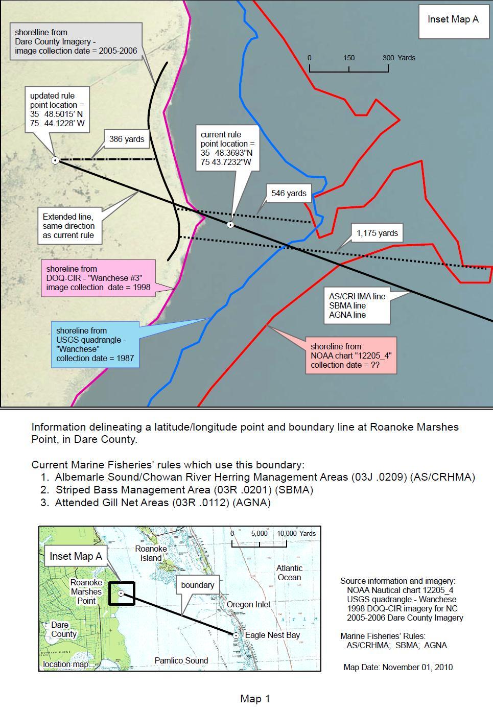
1 FISCAL IMPACTS OF PROPOSED AMENDMENTS TO RULES 15A NCAC 03J.0209, 03R and 03R.0201 ALBEMARLE SOUND MANAGEMENT AREA SOUTHERN BOUNDARY COORDINATE CHANGE Marine Fisheries Commission (MFC) Agency Contact: Impact Summary: Catherine Blum, Fishery Management Plan and Rulemaking Coordinator N.C. Division of Marine Fisheries 3441 Arendell Street Morehead City, NC (252) De minimus Rule State Government: No Local Government: No Private Industry: No Substantial Impact: No Authority: G.S (Rules); G.S (Regulation of Fishing and Fisheries); G.S. 143B (Marine Fisheries Commission-Powers and Duties) Necessity: In accordance with the N.C. Estuarine Striped Bass Fishery Management Plan (FMP), the proposed amendments will re-establish a coordinate point on land that has eroded for Roanoke Marshes Point, the western point of the southern boundary of the Albemarle Sound Management Area (ASMA). The orientation of the boundary line remains unchanged. Establishing a new point is necessary to complete the management area line and facilitate fishing operations and enforcement. These rule changes are consistent with the principles of Executive Order 70. Summary: The purpose of these rule changes (see Proposed Rule Changes section below) is to help the general public and N.C. marine patrol officers more easily distinguish the southern boundary of the ASMA. The N.C. Marine Patrol has indicated that the coordinate point on the western shore of the ASMA boundary is no longer located above normal water level as a result of erosion. Thus, the selection of a point on land is needed for compliance with the N.C. Estuarine Striped Bass FMP and for enforceability. The orientation of the line remains unchanged. The proposed effective date of these rule changes is May 1, Purpose of Rules: The purpose of these rule changes is to help the general public and N.C. marine patrol officers more easily distinguish the southern boundary of the ASMA. This proposal will alter three rules that reference the proposed coordinate point change of the southern boundary of the ASMA: 15A NCAC 03J.0209 Albemarle Sound/Chowan River Herring Management Areas, 15A NCAC 03R.0112 Attended Gill Net Areas and 15A NCAC 03R.0201 Striped Bass Management Areas. Each of these rules references the same western point of the southern boundary line of the ASMA and should be amended simultaneously (see Map 1 below). Through the 1
2 development of the amendment to the N.C. Estuarine Striped Bass FMP marine patrol officers indicated the coordinate point on the western shore of the ASMA boundary was no longer located above normal water level as a result of erosion. The selection of a point on land is needed for compliance with the FMP and for enforceability. The point location needs to be located far enough inland so that shoreline erosion will not be a problem for years to come. Extending the line to a point on land clearly defines the boundaries between the management areas of the ASMA and Central Southern Management Area (CSMA). This eliminates uncertainty with determining in which management area a fishermen and/or their gear is located. Basic Economic Impact: Any impacts from the proposed rule amendments will likely be negligible due to the relatively small area affected. The purpose of the rule changes is to help the general public and N.C. marine patrol officers more easily distinguish the southern boundary of the ASMA. Should these rules not be adopted the existing boundary line would remain in place, which does not induce any notable costs on the public or law enforcement. Benefits: While there are no quantifiable economic benefits to the proposed rule change, both the public and law enforcement will benefit by being able to better distinguish the boundary lines of the ASMA due to presence of easily identified landmarks. Costs: There are no costs associated with the proposed rule changes. Substantial Impact Declaration: The proposed rule amendments do not have a substantial economic impact. 2
3 Proposed Rule Changes: 15A NCAC 03J.0209 ALBEMARLE SOUND/CHOWAN RIVER HERRING MANAGEMENT AREAS (a) The Albemarle Sound Herring Management Area is defined as Albemarle Sound and all its joint water tributaries; Currituck Sound; Roanoke and Croatan sounds and all their joint water tributaries, including Oregon Inlet, north of a line beginning on the west shore at a point ' N ' W N W on Roanoke Marshes Point; running southeasterly to the east shore to a point ' N ' W on the north point of Eagles Nest Bay. (b) The Chowan River Herring Management Area is defined as that area northwest of a line beginning on the west shore at a point ' N ' W on Black Walnut Point; running northeasterly to the east shore to a point ' N ' W on Reedy Point, to the North Carolina/Virginia state line; including the Meherrin River. (c) Effective January 1, 2001, it is unlawful to use drift gill nets in the Albemarle Sound and Chowan River river herring management areas with a mesh length less than three inches from January 1 through May 15. Authority G.S ; ; 143B
4 15A NCAC 03R.0112 ATTENDED GILL NET AREAS (a) The attended gill net areas referenced in 15A NCAC 03J.0103(g) are delineated in the following areas: (1) Pamlico River, west of a line beginning at a point ' N ' W on Ragged Point; running southwesterly to a point ' N ' W on Mauls Point; (2) Within 200 yards of any shoreline in Pamlico River and its tributaries east of a line beginning at a point ' N ' W on Ragged Point; running southwesterly to a point ' N ' W on Mauls Point; and west of a line beginning at a point ' N ' W on Roos Point; running southerly to a point at ' N ' W on Pamlico Point; (3) Pungo River, east of the northern portion of the Pantego Creek breakwater and a line beginning at a point ' N ' W on the northern side of the breakwater near Tooleys Point; running southeasterly to a point ' N ' W on Durants Point; (4) Within 200 yards of any shoreline in Pungo River and its tributaries west of the northern portion of the Pantego Creek breakwater and a line beginning at a point ' N ' W on the northern side of the breakwater near Tooleys Point; running southeasterly to a point ' N ' W on Durants Point; and west of a line beginning at a point ' N ' W on Roos Point; running southerly to a point at ' N ' W on Pamlico Point; (5) Neuse River and its tributaries northwest of the Highway 17 highrise bridge; (6) Trent River and its tributaries; and (7) Within 200 yards of any shoreline in Neuse River and its tributaries east of the Highway 17 highrise bridge and south and west of a line beginning on Maw Point at a point ' N ' W; running southeasterly near the Maw Point Shoal Marker "2" to a point ' N ' W; running southeasterly near the Neuse River Entrance Marker "NR" to a point ' N ' W; running southerly to a point ' N ' W near Point of Marsh in Neuse River. In Core and Clubfoot creeks, the Highway 101 Bridge constitutes the attendance boundary. (b) The attended gill net areas referenced in 15A NCAC 03J.0103(h) are delineated in the following coastal and joint fishing waters of the state south of a line beginning on Roanoke Marshes Point at a point ' N ' W; N W; running southeasterly to a point ' N ' W on Eagles Nest Bay to the South Carolina State line: (1) All primary nursery areas described in 15A NCAC 03R.0103, all permanent secondary nursery areas described in 15A NCAC 03R.0104, and no-trawl areas described in 15A NCAC 03R.0106(2), (4), (5), (7), (8), (10), (11), and (12); (2) In the area along the Outer Banks, beginning at a point ' N ' W on Eagles Nest Bay; running northwesterly to a point ' N ' W west of Pea Island; running southerly to a point ' N ' W west of Beach Slough; running 4
5 southeasterly and passing near Beacon "2" in Chicamicomico Channel to a point ' N ' W west of the Rodanthe Pier; running southwesterly to a point ' N ' W on Gull Island; running southerly to a point ' N ' W near Beacon "2" in Avon Channel ; running southwesterly to a point ' N ' W near Beacon "2" in Cape Channel; running southwesterly to a point ' N ' W near Beacon "36" in Rollinson Channel; running southeasterly to a point ' N ' W near Beacon "35" in Rollinson Channel; running southwesterly to a point ' N ' W near a "Danger" Beacon northwest of Austin Reef; running southwesterly to a point ' N ' W on Legged Lump; running southeasterly to a point ' N ' W south of Legged Lump; running southwesterly to a point ' N ' W near the west end of Clarks Reef; running westerly to a point ' N ' W near Nine Foot Shoal Channel; running southerly to a point ' N ' W near North Rock; running southwesterly to a point ' N ' W near Beacon "HL"; running southerly to a point ' N ' W; running southerly to a point ' N ' W on Wainwright Island; running easterly to a point ' N ' W on Core Banks; running northerly along the shoreline and across the inlets following the Colregs Demarcation line to the point of beginning; (3) In Core and Back sounds, beginning at a point ' N ' W on Core Banks; running northwesterly to a point ' N ' W on Wainwright Island; running southerly to a point ' N ' W; running southeasterly to a point ' N ' W; running southwesterly to a point ' N ' W; running westerly to a point ' N ' W; running southwesterly to a point ' N ' W; running northwesterly to a point ' N ' W; running southerly to a point ' N ' W; running southwesterly to a point ' N ' W; running southwesterly to a point ' N ' W; running southwesterly to a point ' N ' W; running southwesterly to a point ' N ' W; running southwesterly to a point ' N ' W near Beacon "37A"; running southwesterly to a point ' N ' W; running westerly to a point ' N ' W near Beacon "35" in Back Sound; running westerly to a point ' N ' W near Buoy "3"; running southwesterly to a point ' N ' W on Shackleford Banks; running easterly and northeasterly along the shoreline and across the inlets following the COLREGS Demarcation lines to the point of beginning; (4) Within 200 yards of any shoreline in the area upstream of the ' W longitude line beginning at a point ' N ' W near Roos Point in Pamlico River; running southeasterly to a point ' N ' W near Point of Marsh in Neuse River; and 5
6 (5) Within 50 yards of any shoreline east of the ' W longitude line beginning at a point ' N ' W near Roos Point in Pamlico River; running southeasterly to a point ' N ' W near Point of Marsh in Neuse River, except from October 1 through November 30, south and east of Highway 12 in Carteret County and south of a line from a point ' N ' W on Camp Point; running easterly to a point at ' N ' W on Core Banks; to the South Carolina State Line. Authority G.S ; ; ; ; 143B
7 15A NCAC 03R.0201 STRIPED BASS MANAGEMENT AREAS (a) The Albemarle Sound Management Area is designated as Albemarle Sound and all its joint and inland water tributaries, (except for the Roanoke, Middle, Eastmost and Cashie rivers), Currituck, Roanoke and Croatan sounds and all their joint and inland water tributaries, including Oregon Inlet, north of a line beginning at a point N W N W on Roanoke Marshes Point, running southeasterly to a point N W on the north point of Eagle Nest Bay. (b) The Roanoke River Management Area is designated as Roanoke River and its joint and inland tributaries, including Middle, Eastmost and Cashie rivers, up to the Roanoke Rapids dam. (c) The Central/Southern Management Area is designated as all internal coastal, and joint and contiguous inland waters south of a line beginning at a point N W N W on Roanoke Marshes Point, running southeasterly to a point N W on the north point of Eagle Nest Bay, to the South Carolina line. Authority G.S ; ; ; 143B
8 8
REQUEST FOR TECHNICAL CHANGE
 REQUEST FOR TECHNICAL CHANGE AGENCY: Marine Fisheries Commission RULE CITATION: 1A NCAC 0J.0 DEADLINE FOR RECEIPT: Wednesday, January 1, 01 NOTE WELL: This request when viewed on computer extends several
15A NCAC 03J.0103 is amended with changes as published in 30:03 NCR as follows:
 1 1 1 1 1 1 1 1 0 1 0 1 1A NCAC 0J.0 is amended with changes as published in 0:0 NCR 1- as follows: 1A NCAC 0J.0 GILL NETS, SEINES, IDENTIFICATION, RESTRICTIONS (a) It is unlawful to use gill nets: (1)
FISCAL IMPACTS OF PROPOSED AMENDMENTS TO RULE 15A NCAC 03Q.0202 CASHIE RIVER JOINT AND COASTAL WATERS BOUNDARY LINE CHANGE
 FISCAL IMPACTS OF PROPOSED AMENDMENTS TO RULE 15A NCAC 03Q.0202 CASHIE RIVER JOINT AND COASTAL WATERS BOUNDARY LINE CHANGE Marine Fisheries Commission (MFC) Agency Contact: Impact Summary: Authority: Catherine
FISCAL IMPACTS OF PROPOSED AMENDMENTS TO THE N.C. RIVER HERRING FISHERY MANAGEMENT PLAN
 1 FISCAL IMPACTS OF PROPOSED AMENDMENTS TO THE N.C. RIVER HERRING FISHERY MANAGEMENT PLAN Rule Amendments: Name of Commission: Agency Contact: 15A NCAC 03J.0209 ALBEMARLE SOUND/CHOWAN RIVER RIVER HERRING
15A NCAC 03O.0506 SPECIAL PERMIT REQUIRED FOR SPECIFIC MANAGEMENT PURPOSES
 15A NCAC 03O.0506 SPECIAL PERMIT REQUIRED FOR SPECIFIC MANAGEMENT PURPOSES The Fisheries Director may, by proclamation, require individuals taking marine and estuarine resources regulated by the Marine
Amendment 1 to the NC Red Drum FMP MFC Meeting
 Amendment 1 to the NC Red Drum FMP MFC Meeting 4-22-2008 Summary of DMF and AC Recommendations and Public Comment Inland AC Raleigh 3/4/08 Central AC New Bern 3/5/08 Northeast AC Buxton 3/6/08 Southeast
SUBCHAPTER 03L SHRIMPS, CRAB, AND LOBSTER SECTION SHRIMP
 SUBCHAPTER 03L SHRIMPS, CRAB, AND LOBSTER SECTION.0100 - SHRIMP 15A NCAC 03L.0101 SHRIMP HARVEST RESTRICTIONS (a) It is unlawful to take shrimp until the Fisheries Director, by proclamation, opens the
Columbia River Fishery Notice
 Columbia River Fishery Notice Oregon Department of Fish and Wildlife January 29, 2014 Compact Action The Columbia River Compact agencies of Oregon and Washington met today and took the following actions:
FISCAL NOTE FOR PROPOSED AMENDMENTS TO RULE 15A NCAC 03O A NCAC 03O.0503 PERMIT CONDITIONS; SPECIFIC
 FISCAL NOTE FOR PROPOSED AMENDMENTS TO RULE 15A NCAC 03O.0503 SPINY DOGFISH DEALER PERMIT Rule Amendments: Name of Commission: Agency Contact: Impact Summary: 15A NCAC 03O.0503 PERMIT CONDITIONS; SPECIFIC
Columbia River Fishery Notice
 Columbia River Fishery Notice Oregon Department of Fish and Wildlife July 26, 2018 Compact Action The Columbia River Compact agencies of Oregon and Washington met today and took the following actions:
BLACK SEA BASS NORTH OF CAPE HATTERAS DEALER PERMIT ISSUE PAPER. June 12, 2008 (REVISED) (NOTE: proposed rule under construction, eff.
 (NOTE: proposed rule under construction, eff.") BLACK SEA BASS NORTH OF CAPE HATTERAS DEALER PERMIT ISSUE PAPER June 12, 2008 (REVISED) (NOTE: proposed rule under construction, eff. July 1, 2008) I. ISSUE The requirement for licensed dealers to have
BLACK SEA BASS NORTH OF CAPE HATTERAS DEALER PERMIT ISSUE PAPER June 12, 2008 (REVISED) (NOTE: proposed rule under construction, eff. July 1, 2008) I. ISSUE The requirement for licensed dealers to have
The Fisheries Reform Act of The Joint Legislative Commission on Seafood and Aquaculture March 30, 2010
 The Fisheries Reform Act of 1997 The Joint Legislative Commission on Seafood and Aquaculture March 30, 2010 History July 1, 1994 Moratorium on Commercial Fishing Licenses Based on wide range of concerns
MENHADEN MANAGEMENT FOR THE ATLANTIC OCEAN REDUCTION FISHERY INFORMATION PAPER. September 24, 2009
 MENHADEN MANAGEMENT FOR THE ATLANTIC OCEAN REDUCTION FISHERY INFORMATION PAPER September 24, 2009 I. ISSUE Conflict between recreational anglers, the reduction fishery, and bycatch II. ORIGINATION Marine
CDSOA Carolinas Fleet Oriental to Manteo/Ocracoke Cruise Loop
 CDSOA Carolinas Fleet Oriental to Manteo/Ocracoke Cruise Loop May 23-30, 2009 Please respond ASAP! Questions? Contact Fleet Captain Bob Perrone Ph: 919-782-6406; Email: rperronenc@aol.com Or Fleet Secretary
Atlantic States Marine Fisheries Commission
 Atlantic States Marine Fisheries Commission DRAFT ADDENDUM I TO THE OMNIBUS AMENDMENT TO THE INTERSTATE FISHERY MANAGEMENT PLANS FOR SPANISH MACKEREL, SPOT, AND SPOTTED SEATROUT FOR PUBLIC COMMENT Spanish
North Carolina Department of Environment and Natural Resources
 North Carolina Department of Environment and Natural Resources Pat McCrory Governor Donald R. van der Vaart Secretary MEMORANDUM To: From: Southern Regional Advisory Committee Trish Murphey Stephen Taylor
JUNE 2018 RECREATIONAL SHRIMPING REGULATIONS
 K STATE OF ALABAMA DEPARTMENT OF CONSERVATION AND NATURAL RESOURCES MARINE RESOURCES DIVISION POST OFFICE BOX 189 DAUPHIN ISLAND, AL 36528 TEL (251) 861-2882 FAX (251) 861-8741 JUNE 2018 RECREATIONAL SHRIMPING
JUNE 2018 RECREATIONAL SHRIMPING REGULATIONS
 K STATE OF ALABAMA DEPARTMENT OF CONSERVATION AND NATURAL RESOURCES MARINE RESOURCES DIVISION POST OFFICE BOX 189 DAUPHIN ISLAND, AL 36528 TEL (251) 861-2882 FAX (251) 861-8741 JUNE 2018 RECREATIONAL SHRIMPING
Coastal Harbors and Waterways, NC (Shallow Draft Navigation) (O&M)
 (O&M)") Coastal Harbors and Waterways, NC (Shallow Draft Navigation) (O&M) Shallow draft coastal harbors include a subsistence harbor at Silver Lake CONGRESSIONAL DISTRICT: NC 3 and 7 DATE: 23 February 2015 1.
Coastal Harbors and Waterways, NC (Shallow Draft Navigation) (O&M) Shallow draft coastal harbors include a subsistence harbor at Silver Lake CONGRESSIONAL DISTRICT: NC 3 and 7 DATE: 23 February 2015 1.
Establish interim harvest reductions that end overfishing and rebuild the spawning stock biomass by 2015.
 Interim Management Measures for Achieving Sustainable Harvest I. Issue Establish interim harvest reductions that end overfishing and rebuild the spawning stock biomass by 2015. II. Background The 2009
15A NCAC 03O.0101, 15A NCAC 03O.0106,
 1 Fiscal Impacts of Proposed Rule Changes to the Ocean Fishing Pier License and Ocean Fishing Pier Blanket Coastal Recreational Fishing License to Reflect Statutory Changes Implemented in Session Law 2013-360
North Carolina. Striped Mullet FMP. Update
 North Carolina Striped Mullet FMP Update Presentation for the Marine Fisheries Commission January 24, 2008 COMMERCIAL HARVEST 4,000,000 2,000,000 3,500,000 3,000,000 Landings (lb) Value ($) 1,800,000
APRIL 2017 COMMERCIAL SHRIMPING REGULATIONS
 K STATE OF ALABAMA DEPARTMENT OF CONSERVATION AND NATURAL RESOURCES MARINE RESOURCES DIVISION POST OFFICE BOX 189 DAUPHIN ISLAND, AL 36528 TEL (251) 861-2882 FAX (251) 861-8741 APRIL 2017 COMMERCIAL SHRIMPING
OREGON AND WASHINGTON DEPARTMENTS OF FISH AND WILDLIFE JOINT STAFF REPORT SUMMER FACT SHEET NO.
 OREGON AND WASHINGTON DEPARTMENTS OF FISH AND WILDLIFE JOINT STAFF REPORT SUMMER FACT SHEET NO. 1b Columbia River Compact/Joint State Hearing June 14, 2017 Fisheries under consideration: Estuary Recreational
***This summary does not include shad and herring net requirements.***
 South Carolina Department of Natural Resources Marine Resources Division Summary of Seine and Gill Net Laws (Saltwater) 2013-2014 This document should be kept on board all vessels using seines or gill
Coastal Harbors and Waterways, NC (Shallow Draft Navigation) (O&M)
 (O&M)") Coastal Harbors and Waterways, NC (Shallow Draft Navigation) (O&M) Shallow draft coastal harbors include a subsistence harbor at Silver Lake CONGRESSIONAL DISTRICT: NC 3, 7 DATE: 23 April 2018 1. AUTHORIZATION:
Coastal Harbors and Waterways, NC (Shallow Draft Navigation) (O&M) Shallow draft coastal harbors include a subsistence harbor at Silver Lake CONGRESSIONAL DISTRICT: NC 3, 7 DATE: 23 April 2018 1. AUTHORIZATION:
SEDAR 18 Working Paper Prepared by Lee Paramore February 11, 2009
 SEDAR 18 Working Paper Prepared by Lee Paramore February 11, 2009 An Estimate of Red Drum Removals from the North Carolina Estuarine Gill Net Fishery Occurring from both Recreational Users of Gill Nets
Marine Fisheries Management in North Carolina
 Marine Fisheries Management in North Carolina Marine Fisheries Study Committee Jan. 5, 2012 Pounds (millions) Dollars (millions) Total Commercial Landings & Value 250 200 150 100 50 0 120 100 80 60 40
RECREATIONAL WATERS - SAMPLING STATIONS N2. ATLANTIC OCEAN - COROLLA, BEACH ACCESS ACROSS FROM CURRITUCK LIGHTHOUSE.
 RECREATIONAL WATERS - SAMPLING STATIONS NORTHERN AREA N1. ATLANTIC OCEAN - COROLLA, END OF PAVED ROAD, BEACH ACCESS RAMP. N2. ATLANTIC OCEAN - COROLLA, BEACH ACCESS ACROSS FROM CURRITUCK LIGHTHOUSE. N3.
CORPS FACTS. Harbor Dredging U.S. ARMY CORPS OF ENGINEERS BUILDING STRONG
 CORPS FACTS Harbor Dredging U.S. ARMY CORPS OF ENGINEERS BUILDING STRONG Disaster Response Sedimentation in the channel is caused by the normal cycle of silt movement, erosion from high water or heavy
FALL FACT SHEET NO. 1 Columbia River Compact July 29, Non-Indian Select Areas
 FALL FACT SHEET NO. 1 Columbia River Compact July 29, 2004 Fisheries Under Consideration: Non-Indian commercial mainstem Non-Indian Select Areas MANAGEMENT GUIDELINES Salmon A Management Agreement for
Coastal Harbors and Waterways, NC (Shallow Draft Navigation) (O&M)
 (O&M)") Coastal Harbors and Waterways, NC (Shallow Draft Navigation) (O&M) Shallow draft coastal harbors include a subsistence harbor at Silver Lake CONGRESSIONAL DISTRICT: NC 3 and 7 DATE: 23 February 2015 1.
Coastal Harbors and Waterways, NC (Shallow Draft Navigation) (O&M) Shallow draft coastal harbors include a subsistence harbor at Silver Lake CONGRESSIONAL DISTRICT: NC 3 and 7 DATE: 23 February 2015 1.
OREGON AND WASHINGTON DEPARTMENTS OF FISH AND WILDLIFE JOINT STAFF REPORT SUMMER FACT SHEET NO.
 OREGON AND WASHINGTON DEPARTMENTS OF FISH AND WILDLIFE JOINT STAFF REPORT SUMMER FACT SHEET NO. 1 Columbia River Compact/Joint State Hearing June 28, 2018 Fisheries under consideration: Treaty commercial
NORTH CAROLINA SPOTTED SEATROUT FISHERY MANAGEMENT PLAN PREPARED BY THE SPOTTED SEATROUT FISHERY MANAGEMENT PLAN ADVISORY COMMITTEE AND THE
 NORTH CAROLINA SPOTTED SEATROUT FISHERY MANAGEMENT PLAN PREPARED BY THE SPOTTED SEATROUT FISHERY MANAGEMENT PLAN ADVISORY COMMITTEE AND THE NORTH CAROLINA DIVISION OF MARINE FISHERIES DEPARTMENT OF ENVIRONMENT
Areas 11, 21 to 27, 111, 121 to 127
 Map/page Name Map/page Name 24 Scott Islands 32 Saranac Island 25 Topknot 33 Vargas Island to Dunlap Island 26 Holberg Inlet 34 Broken Islands Group 27 Brooks Bay 36 Folger Passage 28 Checleset Bay 37
OCTOBER 2018 COMMERCIAL SHRIMPING REGULATIONS
 STATE OF ALABAMA DEPARTMENT OF CONSERVATION AND NATURAL RESOURCES MARINE RESOURCES DIVISION POST OFFICE BOX 189 DAUPHIN ISLAND, AL 36528 TEL (251) 861-2882 FAX (251) 861-8741 OCTOBER 2018 COMMERCIAL SHRIMPING
ATLANTIC OCEAN STRIPED BASS FISHERY COMMERCIAL HOOK-AND-LINE ISSUE PAPER
 ATLANTIC OCEAN STRIPED BASS FISHERY COMMERCIAL HOOK-AND-LINE ISSUE PAPER April 20, 2011 I. ISSUE The Atlantic Ocean striped bass fishery has been managed for three traditional gear types: beach seine,
Connecticut River American Shad Sustainability Plan Update
 Connecticut River American Shad Sustainability Plan Update September 2017 Connecticut Department of Energy and Environmental Protection Introduction Update to Initial Connecticut Plan implemented beginning
CDSOA Carolinas Fleet Oriental to Manteo Cruise Loop September 23-October 2
 CDSOA Carolinas Fleet Oriental to Manteo Cruise Loop September 23-October 2 Questions? Contact Cruise Captain Shanna Paxton at cdwanderlust@cox.net or Fleet Captain Lou Ostendorff at 919-676-7437 or ostendorff@bellsouth.net
Oregon Administrative Rules Oregon Department of Fish and Wildlife
 DIVISION 042 Columbia River System Commercial Fisheries 635-042-0001 Management and Catch Reporting Areas Management and Catch Reporting Zones shall include those waters of the Columbia River defined as
Oregon Administrative Rules Oregon Department of Fish and Wildlife
 DIVISION 042 Columbia River System Commercial Fisheries 635-042-0001 Management and Catch Reporting Areas Management and Catch Reporting Zones shall include those waters of the Columbia River defined as
CHAPTER 260. (House Bill 964) Atlantic Coastal Bays Dredging for Oysters and Clams Prohibition
 Atlantic Coastal Bays Dredging for Oysters and Clams Prohibition") MARTIN O MALLEY, Governor Ch. 260 CHAPTER 260 (House Bill 964) AN ACT concerning Atlantic Coastal Bays Dredging for Oysters and Clams Prohibition FOR the purpose of prohibiting the use of dredging to catch
MARTIN O MALLEY, Governor Ch. 260 CHAPTER 260 (House Bill 964) AN ACT concerning Atlantic Coastal Bays Dredging for Oysters and Clams Prohibition FOR the purpose of prohibiting the use of dredging to catch
Order Adopting Amendments. Title 58. Recreation Part II. Fish and Boat Commission Chapters 97, 109, 111 and 115 Boating. Preamble
 Order Adopting Amendments COMMONWEALTH OF PENNSYLVANIA PENNSYLVANIA FISH AND BOAT COMMISSION Title 58. Recreation Part II. Fish and Boat Commission Chapters 97, 109, 111 and 115 Boating Preamble The Fish
UNOFFICIAL COPY OF HOUSE BILL 853 CHAPTER
 UNOFFICIAL COPY OF HOUSE BILL 853 M2 6lr1662 By: Delegates Bozman, Cane, V. Clagett, Conway, and Hixson Introduced and read first time: February 8, 2006 Assigned to: Environmental Matters Committee Report:
CRC Inlet Management Study. Matt Slagel Shoreline Management Specialist
 CRC Inlet Management Study Matt Slagel Shoreline Management Specialist Study Origin CRC shall study feasibility of creating new AEC for lands adjacent to mouth of Cape Fear River (HB 819) Collaborate with
JOINT STAFF REPORT WINTER FACT SHEET NO. 9 Columbia River Compact March 18, 2004
 JOINT STAFF REPORT WINTER FACT SHEET NO. 9 Columbia River Compact March 18, 2004 Purpose: To review ongoing commercial fisheries and consider non-indian commercial fishing seasons for salmon, smelt and
WILMINGTON, N.C., DISTRICT
 WILMINGTON, N.C., DISTRICT This district comprises central and eastern North Carolina and a portion of southcentral Virginia, embraced in drainage basins tributary to the Atlantic Ocean from the southern
North Carolina American Shad Sustainable Fishery Plan
 North Carolina American Shad Sustainable Fishery Plan Prepared by North Carolina Division of Marine Fisheries 3441 Arendell Street P.O. Box 769 Morehead City, NC 28557 North Carolina Wildlife Resources
OREGON AND WASHINGTON DEPARTMENTS OF FISH AND WILDLIFE JOINT STAFF REPORT - WINTER FACT SHEET NO.
 OREGON AND WASHINGTON DEPARTMENTS OF FISH AND WILDLIFE JOINT STAFF REPORT - WINTER FACT SHEET NO. 1 Columbia River Compact/Joint State Hearing January 29, 2019 Fisheries under consideration: Zone 6 treaty
Atlantic States Marine Fisheries Commission
 Atlantic States Marine Fisheries Commission 050 N. Highland Street Suite 00A-N Arlington, VA 0 703.84.0740 703.84.074 (fax) www.asmfc.org MEMORANDUM January 6, 05 TO: FROM: Atlantic Striped Bass Management
ORDINANCE NO. WHEREAS, Downtown Bellingham and the Fairhaven commercial core are places where people come to play, work, shop, and live;
 ORDINANCE NO. AN ORDINANCE OF THE CITY OF BELLINGHAM, WASHINGTON AMENDING BELLINGHAM MUNICIPAL CODE PROVISIONS 10.24.070, 11.48.140, 11.52.010, EXTENDING THE HOURS OF RESTRICTION FOR SITTING AND LYING
Fishing for Red Drum
 Fishing for Red Drum Overview: Grade Level 5 th -8 th Objectives * To be able generate a graph based on current fishery data. * To be able to predict red drum weights and ages based on length. * To understand
(e) For the purpose of this section, a menhaden dealer is:
 For the purpose of this section, a menhaden dealer is:") Fis 603.21 Atlantic Menhaden. (a) No person shall take, land, possess, or transfer possession of Atlantic menhaden (Brevortia tyrannus) while on or leaving the waters under the jurisdiction of the state
Fis 603.21 Atlantic Menhaden. (a) No person shall take, land, possess, or transfer possession of Atlantic menhaden (Brevortia tyrannus) while on or leaving the waters under the jurisdiction of the state
PUBLIC UTILITY COMMISSION OF TEXAS (PUC) DOCKET NO
 DOCKET NO") Application of Oncor Electric Delivery Company LLC to Amend its Certificate of Convenience and Necessity for a Proposed CREZ 138 kv Transmission Line in Ector County, Texas. (Ector County North-Moss CCN)
Application of Oncor Electric Delivery Company LLC to Amend its Certificate of Convenience and Necessity for a Proposed CREZ 138 kv Transmission Line in Ector County, Texas. (Ector County North-Moss CCN)
VIRGINIA: CitJto/~<Pn Friday 1st day 0/ November, Fee 4. Parking or Stopping Violations * * *
 VIRGINIA: CitJto/~
OREGON AND WASHINGTON DEPARTMENTS OF FISH AND WILDLIFE JOINT STAFF REPORT - FALL FACT SHEET NO.
 OREGON AND WASHINGTON DEPARTMENTS OF FISH AND WILDLIFE JOINT STAFF REPORT - FALL FACT SHEET NO. 3 Columbia River Compact/Joint State Hearing August 28, 2018 Fisheries under consideration: Non-treaty mainstem
CHAPTER 6 10/29/2018 Clean Version REGULATING PIERS, WHARVES, MOORING BUOYS, SWIMMING RAFTS AND INFLATABLES ON ROCK LAKE
 1 2 3 4 5 6 7 8 9 10 11 12 13 14 15 16 17 18 19 20 21 22 23 24 25 26 27 28 29 30 31 32 33 34 35 36 37 38 39 40 41 42 43 44 45 46 CHAPTER 6 10/29/2018 Clean Version REGULATING PIERS, WHARVES, MOORING BUOYS,
CHAPTER 20 SPEED ZONES
 CHAPTER 20 SPEED ZONES 20.01 STATUTORY INVESTIGATION 20.02 EFFECTIVE DATE 20.03 SPEED LIMITS (1) Town of Greenbush (2) Town of Herman (3) Town of Holland (4) Town of Lima (5) Town of Mosel (6) Town of
SACO RIVER AND CAMP ELLIS BEACH SACO, MAINE SECTION 111 SHORE DAMAGE MITIGATION PROJECT APPENDIX F ECONOMIC ASSESSMENT
 SACO RIVER AND CAMP ELLIS BEACH SACO, MAINE SECTION 111 SHORE DAMAGE MITIGATION PROJECT APPENDIX F ECONOMIC ASSESSMENT Department of the Army New England District, Corps of Engineers 696 Virginia Road
SECTION II NM 11/13 NAVIGATION PUBLICATIONS COAST PILOT CORRECTIONS. Chapter 4 Paragraphs 85 to 86; read: (85)
") NAVIGATION PUBLICATIONS COAST PILOT CORRECTIONS COAST PILOT 1 42 Ed 2012 Change No. 13 LAST NM 9/13 Chapter 4 Paragraph 9; read: (9) Round Rock, which uncovers, and The Boring Stone, 3 feet high and bare,
NAVIGATION PUBLICATIONS COAST PILOT CORRECTIONS COAST PILOT 1 42 Ed 2012 Change No. 13 LAST NM 9/13 Chapter 4 Paragraph 9; read: (9) Round Rock, which uncovers, and The Boring Stone, 3 feet high and bare,
Governor Roy Cooper Office of the Governor Mail Service Center Raleigh, NC April 25, Dear Governor Cooper,
 Governor Roy Cooper Office of the Governor 20301 Mail Service Center Raleigh, NC 27699-0301 April 25, 2018 Dear Governor Cooper, The North Carolina Watermen United (NCWU) requests that some of the seats
Coastal Hazards and Management in North Carolina. Braxton Davis April 14, 2015
 Coastal Hazards and Management in North Carolina Braxton Davis April 14, 2015 Coastal Facts and Figures 320 miles of ocean beaches 12,000+ miles of estuarine shoreline 2 million + acres of sounds, creeks,
68D Broward County Boating Restricted Areas.
 68D-24.008 Broward County Boating Restricted Areas. (1) For the purpose of regulating speed and operation of vessel traffic on and adjacent to the Florida Intracoastal Waterway in Broward County, Florida,
MOREHEAD CITY HARBOR, NC. Dredged Material Management Plan (DMMP)
") MOREHEAD CITY HARBOR, NC Dredged Material Management Plan (DMMP) Public Meeting/Info Session 15 January 2014 US Army Corps of Engineers Morehead City Harbor DMMP Presentation Topics Morehead City Harbor
MOREHEAD CITY HARBOR, NC Dredged Material Management Plan (DMMP) Public Meeting/Info Session 15 January 2014 US Army Corps of Engineers Morehead City Harbor DMMP Presentation Topics Morehead City Harbor
CHAPTER House Bill No. 1311
 CHAPTER 2017-216 House Bill No. 1311 An act relating to the Lehigh Acres Municipal Services Improvement District, Lee and Hendry Counties; amending chapter 2015-202, Laws of Florida; expanding the territorial
ORDINANCE NO. 10- AN ORDINANCE OF THE COUNTY OF PLUMAS, STATE OF CALIFORNIA, ADDING ARTICLE 10 TO CHAPTER 3 OF TITLE 4 OF THE PLUMAS COUNTY CODE
 ORDINANCE NO. 10- AN ORDINANCE OF THE COUNTY OF PLUMAS, STATE OF CALIFORNIA, ADDING ARTICLE 10 TO CHAPTER 3 OF TITLE 4 OF THE PLUMAS COUNTY CODE The Board of Supervisors of the County of Plumas, State
Joint Atlantic and Gulf States Marine Fisheries Commission
 Joint Atlantic and Gulf States Marine Fisheries Commission Crustacean Workgroup Meeting November 3 rd 2015, 8am-12pm St. Augustine, Florida Draft Agenda The times listed are approximate; the order in which
APRIL 2017 LIVE BAIT
 K STATE OF ALABAMA DEPARTMENT OF CONSERVATION AND NATURAL RESOURCES MARINE RESOURCES DIVISION POST OFFICE BOX 189 DAUPHIN ISLAND, ALABAMA 36528 TEL (251861-2882 FAX (251) 861-8741 APRIL 2017 LIVE BAIT
OREGON AND WASHINGTON DEPARTMENTS OF FISH AND WILDLIFE JOINT STAFF REPORT - WINTER FACT SHEET NO.
 OREGON AND WASHINGTON DEPARTMENTS OF FISH AND WILDLIFE JOINT STAFF REPORT - WINTER FACT SHEET NO. 1a Columbia River Compact/Joint State Hearing January 27, 2016 Fisheries under consideration: Zone 6 recreational
Coastal issues: Beaches and Estuaries. Recent Sea Level: Beaches: Baltimore D.C. Patomac R. Chesapeake Bay
 Coastal issues: Beaches and Estuaries Definitions: Coast = broad zone where both marine & terrestrial processes act It includes the beach, lagoons, marshes, bars etc. Coastal processes act to shape the
A Tale of Two Rivers: The Extirpation of Striped Bass in the Neuse and Tar/Pamlico Rivers. Introduction
 A Tale of Two Rivers: The Extirpation of Striped Bass in the Neuse and Tar/Pamlico Rivers A Coastal Conservation Association North Carolina (CCA NC) White Paper Introduction In North Carolina, estuarine
August 2018 LIVE BAIT
 STATE OF ALABAMA DEPARTMENT OF CONSERVATION AND NATURAL RESOURCES MARINE RESOURCES DIVISION POST OFFICE BOX 189 DAUPHIN ISLAND, ALABAMA 36528 TEL (251861-2882 FAX (251) 861-8741 August 2018 LIVE BAIT THIS
DUNE STABILIZATION AND BEACH EROSION
 DUNE STABILIZATION AND BEACH EROSION CAPE HATTERAS NATIONAL SEASHORE NORTH CAROLINA ROBERT DOLAN PAUL GODFREY U. S. DEPARTMENT OF INTERIOR NATIONAL PARK SERVICE OFFICE OF NATURAL SCIENCE WASHINGTON, D.
OREGON AND WASHINGTON DEPARTMENTS OF FISH AND WILDLIFE JOINT STAFF REPORT - WINTER FACT SHEET NO.
 OREGON AND WASHINGTON DEPARTMENTS OF FISH AND WILDLIFE JOINT STAFF REPORT - WINTER FACT SHEET NO. 3a Columbia River Compact/Joint State Hearing February 21, 2018 Fisheries under consideration: Mainstem
Use Of Nets And Harvest Of Mullet.
 220-3. 03 Use Of Nets And Harvest Of Mullet. (1) Any person possessing, transporting, or using any seine, gill net, trammel net, or other entangling net more than 300 feet in length as measured along the
REQUEST FOR TECHNICAL CHANGE
 REQUEST FOR TECHNICAL CHANGE AGENCY: Marine Fisheries Commission RULE CITATION: 1A NCAC 0I.01 DEADLINE FOR RECEIPT: Friday, April, 01 NOTE WELL: This request when viewed on computer extends several pages.
Recreational Sturgeon Commercial Shad MANAGEMENT GUIDELINES
 OREGON AND WASHINGTON DEPARTMENTS OF FISH AND WILDLIFE JOINT STAFF REPORT - SUMMER FACT SHEET NO. 2 Columbia River Compact/Joint State Hearing June 28, 2005 Fisheries under consideration: Recreational
Nome Harbor Page 2 of 12
 Nome Harbor Nome Harbor Page 2 of 12 Condition of Improvements 30 December 2015 Nome Harbor, Alaska (CWIS No. 010422, 012270, 072742, 087755) Authorization (1) Rivers and Harbors Act, 8 August 1917 (House
ORDINANCE NO AMENDMENT TO THE CITATION ESTATES MPD DEVELOPMENT AGREEMENT
 ORDINANCE NO. 2015- AMENDMENT TO THE CITATION ESTATES MPD DEVELOPMENT AGREEMENT AN ORDINANCE OF THE CITY COUNCIL OF THE CITY OF PALM COAST, FLORIDA, PROVIDING FOR THE SECOND AMENDED AND RESTATED MASTER
BERMUDA CASINO GAMING (DESIGNATED SITE) ORDER 2016 BR 2 / 2017
 ORDER 2016 BR 2 / 2017") QUO FA T A F U E R N T BERMUDA BR 2 / 2017 The Minister responsible for gaming, in exercise of the powers conferred by section 4(1) of the Casino Gaming Act 2014, acting on the advice of the Bermuda Casino
QUO FA T A F U E R N T BERMUDA BR 2 / 2017 The Minister responsible for gaming, in exercise of the powers conferred by section 4(1) of the Casino Gaming Act 2014, acting on the advice of the Bermuda Casino
Downstream Migrant Trapping in Russian River Mainstem, Tributaries, and Estuary
 Downstream Migrant Trapping in Russian River Mainstem, Tributaries, and Estuary Introduction In September 2008, the National Marine Fisheries Service issued the Russian River Biological Opinion, which
The Board of Supervisors of the County of Riverside ordains as Follows:
 ORDINANCE NO. 514 (AS AMENDED THROUGH 514.10) AN ORDINANCE OF THE COUNTY OF RIVERSIDE AMENDING ORDINANCE NO. 514 REGULATING THE USE AND DISCHARGE OF FIREARMS The Board of Supervisors of the County of Riverside
Summary Report of the North Carolina Division of Marine Fisheries Cobia (Rachycentron canadum) Acoustic Tagging. Stephen J. Poland SEDAR58-SID-06
 Acoustic Tagging. Stephen J. Poland SEDAR58-SID-06") Summary Report of the North Carolina Division of Marine Fisheries Cobia (Rachycentron canadum) Acoustic Tagging Stephen J. Poland SEDAR58-SID-06 Submitted: 29 March 2018 This information is distributed
Summary Report of the North Carolina Division of Marine Fisheries Cobia (Rachycentron canadum) Acoustic Tagging Stephen J. Poland SEDAR58-SID-06 Submitted: 29 March 2018 This information is distributed
Starting Bid: $15,000
 Starting Bid: $15,000 Parcel # 12.00593.00 Garage Legal Description Information Lot-005 Block-006 FOREST EDGE ADDITION Eckles Township 20 147 34 Forfeited: 06-222018 Deeded acres: 1.33 Appraised Value
Today: Coastal Issues and Estuaries
 Today: Coastal Issues and Estuaries Coastal issues Human effect on coastlines What is an estuary Why are they so important? Circulation of water in estuary Environmental issues Coastal Issues: Problem
LAW AND PUBLIC SAFETY BOAT REGULATION COMMISSION MOTOR VEHICLE COMMISSION. Readoption with Amendments: N.J.A.C. 13:82. Boating Regulations
 LAW AND PUBLIC SAFETY BOAT REGULATION COMMISSION MOTOR VEHICLE COMMISSION Readoption with Amendments: N.J.A.C. 13:82 Boating Regulations Proposed: August 17, 2009 at 41 N.J.R. 3033(a). Adopted: November
SOUTH ATLANTIC FISHERY MANAGEMENT COUNCIL
 1 SOUTH ATLANTIC FISHERY MANAGEMENT COUNCIL ONE SOUTHPARK CIRCLE, SUITE 306 CHARLESTON, SOUTH CAROLINA 29407-4699 TEL 843/571-4366 or FAX 843/769-4520 Toll Free 1-866/SAFMC-10 E-mail: safmc@safmc.net Web
1-32 NOME HARBOR, ALASKA (CWIS NOS , 87755, 12270, & 10422) Condition of Improvement 30 September 2012
 Condition of Improvement 30 September 2012") NOME HARBOR 1-32 NOME HARBOR, ALASKA (CWIS NOS. 72742, 87755, 12270, & 10422) Condition of Improvement 30 September 2012 AUTHORIZATION: (1) Rivers and Harbors Act, 8 August 1917 (House Doc. 1932, 64th
NOME HARBOR 1-32 NOME HARBOR, ALASKA (CWIS NOS. 72742, 87755, 12270, & 10422) Condition of Improvement 30 September 2012 AUTHORIZATION: (1) Rivers and Harbors Act, 8 August 1917 (House Doc. 1932, 64th
Project Webpage:
 Project Webpage: http://nature.ly/marinesatlanticbightera Coastal Data and Full Metadata: http://easterndivision.s3.amazonaws.com/marine/sab MA/SABMACoastalEcosystems.zip Coastal Chapter: http://easterndivision.s3.amazonaws.com/marine/sab
CANADA PROVINCE OF BRITISH COLUMBIA
 Note: This supplementary Letters Patent has been consolidated from the Supplementary Letters Patents of the three Regional Districts of the Okanagan valley: North Okanagan Regional District; Central Okanagan
REGION B ONLY. Figure Figure Figure Figure Figure Figure Figure Figure 10.60
 221 REGION B ONLY 10.5 LATERAL MARKS 10.5.1 Description of Lateral marks Port hand marks Shape: pillar buoy (Figures 10.53 and 10.54), can lighted buoy (Figures 10.55 and 10.56) or not lighted (Figures
Descriptor term: Descriptor code: Issue date: SECTION A ORGANIZATION PLAN
 SECTION A ORGANIZATION PLAN A.1...DISTRICT LEGAL STATUS A.2...DISTRICT LEGAL DESCRIPTION A.3...ORGANIZATION PLAN A.4...ORGANIZATIONAL CHART A.5...SCHOOL ATTENDANCE AREAS A.6...SCHOOL CALENDAR DISTRICT
Atlantic States Marine Fisheries Commission ADDENDUM XXI TO THE SUMMER FLOUNDER, SCUP AND BLACK SEA BASS FISHERY MANAGEMENT PLAN FOR PUBLIC COMMENT
 Atlantic States Marine Fisheries Commission ADDENDUM XXI TO THE SUMMER FLOUNDER, SCUP AND BLACK SEA BASS FISHERY MANAGEMENT PLAN FOR PUBLIC COMMENT Black Sea Bass Recreational Management in 211 ASMFC Vision
North Carolina Aquaculture Plan for American Eel Management Board August 2 nd, 2017
 North Carolina Aquaculture Plan for 2018 American Eel Management Board August 2 nd, 2017 Background Outline NC Aquaculture Plan: 2017 season results NC Proposed Aquaculture Plan for 2018 and beyond Highlight
FINDING OF NO SIGNIFICANT IMPACT
 DEPARTMENT OF THE ARMY CHARLESTON DISTRICT, CORPS OF ENGINEERS 69A HAGOOD AVENUE CHARLESTON, SOUTH CAROLINA 29403-5107 FINDING OF NO SIGNIFICANT IMPACT EDISTO BEACH COASTAL STORM DAMAGE REDUCTION GENERAL
NC Aquaculture Overview of State Regulations and Agency Partners
 NC Aquaculture Overview of State Regulations and Agency Partners Pete Anderson NCDA&CS Garry Wright NCDMF North Carolina Marine Finfish Aquaculture Best Management Practices (BMP) Training Workshop NC
ORDINANCE NO. SB-3131
 ORDINANCE NO. SB-3131 AN ORDINANCE MAKING FINDINGS AND ESTABLISHING A STAR BOND PROJECT DISTRICT WITHIN THE CITY OF OVERLAND PARK, KANSAS PURSUANT TO K.S.A. 12-17,160 ET SEQ., AS AMENDED (BLUHAWK STAR
ORDINANCE NO CITY OF MONTICELLO ADOPTING TAX INCREMENT FINANCING TAX INCREMENT FINANCING DISTRICT II
 ORDINANCE NO. 2006-59 CITY OF MONTICELLO ADOPTING TAX INCREMENT FINANCING TAX INCREMENT FINANCING DISTRICT II WHEREAS, the City of Monticello, Illinois, desires to adopt tax increment financing pursuant
Submitted by the Alaska Department of Fish and Game at the request of Alaska Board of Fisheries. January 23, 2018
 Submitted by the Alaska Department of Fish and Game at the request of Alaska Board of Fisheries. January 23, 2018 Alaska Board of Fisheries recommendations on Unuk, Chilkat, and King Salmon rivers king
The purpose and needs of the Figure Eight Island Inlet and Shoreline Management Project are as follows:
 Chapter 2 PURPOSE AND NEEDS 1. What are the purpose and needs of this project? The main concern of residents and owners at Figure Eight Island are economic losses resulting from damages to structures and