Emergency Action Plan
|
|
|
- Jane Woods
- 5 years ago
- Views:
Transcription

1 Emergency Action Plan ECY (Rev 06/2016) To request ADA accommodation including materials in a format for the visually impaired, call Ecology Water Resources Program at Persons with impaired hearing may call Washington Relay Service at 711.
2 2

3 (West Lagoon Dike) Emergency Action Plan Project Name: City of Ferndale WWTP West Lagoon Dike Dam Safety Office File Number: WH01514 Location: Ferndale, Whatcom, Nooksack River Owner: City of Ferndale Issue Date: 2/13/1997 Revised Date: 04/2/2018 3
4 4
5 Introduction Why is an Emergency Action Plan (EAP) so important? If an emergency situation arises, you do not want to be scrambling to figure out what to do. Your completed EAP will be an invaluable resource during an unusual event or emergency. It will help you to act quickly and strategically, thereby reducing the risk of injury or loss of life and minimizing property damage. For those of you unfamiliar with the language of dams, two diagrams and a glossary are provided in the Appendix. There are also some tips to get you started on your EAP. Ecology s Dam Safety Office (DSO) is always available to help and assist you. But remember that as the dam owner, you are ultimately responsible for the maintenance and safety of your dam. Table of Contents Note: Since your additions or other changes may affect page numbers, they are left blank here. Dam Basics: impacted area and dam description Location Map Emergency Action Plan Overview (Steps A E) Step A: Detect/recognize the event Step B: Determine the Emergency Level (1-3) Guidance for Determining the Emergency Level Step C: Notification and communication Owner/operator contact numbers List of people, structures and roads at greatest risk Step D: Expected actions: take preventative actions Supplies and resources Step E: Termination and follow-up Appendix I. Why this plan is important, and some initial preparation guidance II. Examples of emergency situations to help determine Emergency Level (1-3) III. Graphics: Dam diagram and Possible dam failures IV. Glossary and Water Equivalent Table V. Signatures for final plan approval VI. For more information VII. Inundation map 5
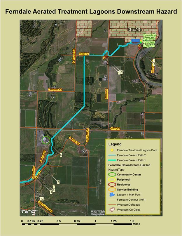
6 Dam Basics: impacted area and dam description Potentially impacted downstream area: (What would be impacted if there was a dam failure?) Please describe the property(s) downstream of the dam (agricultural, residential, industrial, critical wildlife habitat, etc.): There are inhabited structures associated with agricultural land south of the lagoon. Additional information on impacted areas, if available: Located on: within 800 feet West of Nooksack River Downstream flood path: Nooksack River to Bellingham Bay Description of the dam (Refer to graphic of typical dam and Glossary in Appendix, if needed.) Official dam name: City of Ferndale WWTP West Lagoon Dike State I.D. number: WH Dam owner and/or operator: City of Ferndale Owner and/or operator contact numbers: (360) , (360) address: mikeolinger@cityofferndale.org Section 30SE Township 39N Range 2E (or) Latitude: Longitude: County: Whatcom Type of dam (ex: earthfill, concrete, rockfill): Lined WWTP Lagoon, Earth Embankment Dam height: 16 6 Crest length: 710, 1920 Perimeter, Crest width: 13 Maximum storage: 47.6 acre feet. Normal storage: 34.7 acre feet. Downstream hazard classification: Low, class 2 Number of homes in the dam break floodplain (the number of homes that would be in the path of flood water if the dam should fail): 2 6

7 Directions to the dam (note any locked gates or other access issues): The dam can be accessed through a gate located at 5405 Ferndale Rd. Public works will provide access. 7
8 Emergency Action Plan Overview: Steps A - E This flowchart presents the basic steps to take in an unusual event or emergency. Details on each step follow. Step A: Event Detection Detect Event Assess Situation Determine Emergency Level Step B: Emergency Level Determination Level 1 Unusual Event Slowly Developing Level 2 Potential Dam Failure Situation Rapidly Developing Level 3 Urgent Dam Failure appears to be Imminent or is in Progress! Step C: Notification and Communication Notify: Level 1 List Notify: Level 2 List Notify: Level 3 List Step D: Expected Actions Monitor Save Dam Protective Actions Save People EVACUATE Step E: Termination and Follow up Termination and Follow up 8
9 STEP A: Detect/recognize the event Unusual or emergency events can be detected by: Observations made at or near the dam. Earthquakes felt or reported at or near the dam. Other conditions that can cause an unusual or emergency event at the dam. For example, forecasts of a severe weather event, a flash flood, upstream dam failures or releases. STEP B: Determine the Emergency Level (1-3) You need to evaluate the potential extent of the emergency before you notify the appropriate people/agencies. The Emergency Level determines your next steps. Responding to a slowly developing event clearly requires a different response than an imminent dam failure, for example. The Guidance table on the next page is a quick reference guide to events, situations and levels. For more detailed examples, see Appendix. Emergency Level 1 - Unusual event, slowly developing This event is not normal but has not yet threatened the operation or structural integrity of the dam. This event could affect the structural integrity of the dam if left unchecked. Emergency Level 2 - Potential dam failure, rapidly developing This event may eventually lead to dam failure and potential flooding downstream, but there is not an immediate threat of dam failure. This emergency level also applies when uncontrolled flow through the dam s spillway has or is likely to result in flooding of downstream areas, but is not yet affecting buildings or roads, or posing a significant risk to health, safety, or welfare. Emergency Level 3 - Urgent; dam failure appears imminent or is in progress This is an urgent event, where a dam failure is occurring or is clearly about to occur and cannot be prevented. Flash flooding will occur downstream of the dam. The amount of flooding and resulting damage will be dependent upon several factors, such as the water level in the reservoir and the time of year. If the breach occurs during the dry season when the water level in the reservoir level is low, the escaped water will flood a significantly smaller area then when the breach occurs at the time the dam s reservoir is full. If a breach occurs when the dam s reservoir is full, the entire area shown on the Inundation Map (last page of this document) will be flooded. This event level is also applicable when flow through the dam s spillway is flooding buildings or roads. The dam owner will contact 911 and the responsible Emergency Services to evacuate people at risk and close roads in the flood path if necessary. 9
10 Guidance for Determining the Emergency Level (more detailed examples in Appendix; also graphics of typical dam and possible dam failures) Emergency Level 1: Non-emergency, unusual event, slowly developing. Emergency Level 2: Potential dam failure situation, rapidly developing. Emergency Level 3: Urgent; dam failure appears to be imminent or is in progress. Event Situation Emergency Level Measurable earthquake felt or reported within (50) miles of the dam 1 Earthquake Earthquake resulting in visible damage to the dam or appurtenances 2 Earthquake resulting in uncontrolled release of water from the dam 3 Embankment cracking New cracks in the embankment greater than 1/2 inch wide and greater than 2-feet deep, without seepage 1 Cracks in the embankment with seepage emerging 2 Embankment Visual movement/slippage of the embankment slope 1 movement Sudden or rapidly proceeding slides of the embankment slopes 2 National Weather Service issues a flood warning for the area 1 The reservoir elevation reaches the predetermined notification trigger elevation of 6 inches below dam crest 2 Flooding The reservoir elevation reaches the predetermined notification trigger elevation of 3 inches below dam crest 3 Spillway flow is flooding roads and people downstream 3 Flood flows are overtopping the dam 3 Instruments Instrumentation readings beyond predetermined values 1 Damage to the dam or appurtenances with no impacts to the functioning of the dam 1 Sabotage/Vandalism Modification to the dam or appurtenances that could adversely impact the functioning of the dam 1 Damage to the dam or appurtenances that has resulted in seepage flow 2 Damage to the dam or appurtenances that has resulted in uncontrolled water release 3 Verified bomb threat that, if carried out, could result in damage to the dam Security threat 2 Detonated bomb that has resulted in damage to the dam or appurtenances 3 New seepage areas in or near the dam 1 Boils observed downstream of dam 1 Seepage Boils observed downstream of dam with cloudy discharge 2 New seepage areas with cloudy discharge or increasing flow rate 2 Cloudy flow and one or more of the following (with constant reservoir level): 3 accelerating rate of flow, expanding flow at exit point, or buildup of soils Sinkholes Observation of new sinkhole in reservoir area or on embankment 2 Rapidly enlarging sinkhole 3 Principal spillway severely blocked with debris or structurally damaged 1 Spillways Principal spillway leaking with muddy flows 1 Principal spillway blocked with debris and pool is rapidly rising 2 10
11 Step C: Notification and communication Once you have determined the Emergency Level (in Step B), follow the appropriate notification steps below. How you proceed will depend on the identified Emergency Level. Your prepared list of Owner/operator contact numbers and individual responsibilities follows. Emergency Level 1: Slowly developing failure or unusual situation If there is a slowly developing failure or unusual situation, where dam failure is not imminent but could occur if no action is taken, dam-tending personnel should: 1. Contact the appropriate persons associated with your dam. Your list is on the next page, Owner/operator contact numbers. 2. Notify Whatcom County Emergency Services at: (360) of the potential problem and keep them advised of the situation. Be sure to ask if there are any immediate actions you can take to reduce the risk of failure. 3. If the event is during office hours, call the Ecology Dam Safety Office, (360) for an evaluation of the dam. Be sure to ask if there are any immediate actions you can take to reduce the risk of failure. 4. If necessary, implement the preventative actions described under Step D of this plan, under the direction of a professional engineer. 5. If the situation deteriorates, be prepared to notify downstream residents ( List of people, structures and roads at greatest risk follows next page). Emergency Level 2: Potential dam failure, rapidly developing If there is a potential dam failure, contact the appropriate authorities immediately in the order listed below. 1. Call Contact the appropriate persons associated with your dam. Your list is on the next page, Owner/operator contact numbers. 3. Call County/City Emergency Services or Sheriff Name Position Phone 1. Mike Olinger WWTP Chief Operator (360) Kevin Renz Public Works Director (360) Bill Elfo Whatcom Co. Sheriff (360) Call the State Division of Emergency Management a. Call the Duty Officer (available 24 hours/day) at b. Clearly state that this is a dam safety emergency 5. If the event is during office hours, call the Ecology Dam Safety Office, (360) If the situation deteriorates, be prepared to notify downstream residents ( List of people, structures and roads most at risk, after next page). 11
12 Emergency Level 3: Urgent; dam failure appears imminent or is in progress If a dam failure is imminent or in process, immediately contact the appropriate authorities in the order listed below. 1. Call Contact the appropriate persons associated with your dam. Your list is at the bottom of this page, Owner/operator contact numbers. 3. Notify persons immediately downstream from the dam of the failure ( List of people, structures and roads most at risk on next page). Refer also to the Inundation Map, on last page of document. 4. Call County/City Emergency Services or Sheriff Name Position Phone 1. Mike Olinger WWTP Chief Operator (360) Kevin Renz Public Works Director (360) Bill Elfo Whatcom Co. Sheriff (360) Call State Division of Emergency Management a. Call the Duty Officer (available 24 hours/day) at b. Clearly state that this is a dam safety emergency 6. If it is during regular office hours, contact the Ecology Dam Safety Office, (360) Begin any recommended procedures; take preventative actions as described in Step D of this plan under the direction of a professional engineer. Owner/operator contact numbers It is important that no one person becomes overwhelmed during an unusual event or an emergency. The following list indicates who is responsible for each predetermined duty. Name Phone Responsibility 1. Mike Olinger (360) mikeolinger@cityofferndale.org On Location Coordinator 2. Kevin Renz (360) kevinrenz@cityofferndale.org Coordination of Response 3. Bo Westford (360) bowestford@cityofferndale.org Coordination of Equipment / Labor 12
13 List of people, structures and roads at greatest risk In order of proximity to the dam (also refer to Inundation Map at end of document) Type of structure (residence/business/ road/other) Name and address Phone number Approximate depth & time flood may arrive Parcel number Residence 5347 Ferndale Rd Ray Anderson Jim Anderson *This is their preferred contact number cell. (360) ( ) - Depth: < 3 feet Time: 1 minute Residence 5347 Ferndale Rd. Ray Anderson Jim Anderson *Secondary contact. (360) ( ) - Depth: < 3 feet Time: 1 minute Residence 5249 Imhoff Road Hal Hovander (360) ( ) - Depth: < 1 foot Time: 7 minutes Business Silver Reef Casino Slater Road Gary James Head of Security (360) (360) Depth: Time: ( ) - Depth: ( ) - Time: ( ) - Depth: ( ) - Time: 13
14 Step D: Expected actions: take preventative actions The following actions may help to prevent or delay a dam failure after an emergency is first discovered. These actions should only be performed under the direction of the Dam Safety Office, or other qualified professional engineers. This list includes some of the more likely issues; it is not intended as a comprehensive list. (See Appendix for graphics of typical dam and possible failures.) Your list of supplies and resources, which may be needed to carry out the necessary actions, follows the examples. 1. Erosional seepage or leakage (piping) through the embankment, foundation, or abutments Plug the flow with whatever material is available (hay bales, bentonite, or plastic sheeting if the entrance to the leak is in the reservoir). Lower the water level until the flow decreases to a non-erosive velocity or until it stops. Place a blanket filter (a protective sand and gravel filter) over the exit area to hold materials in place. Continue lowering the water level until the reservoir reaches a safe elevation. Continue operating at a reduced level until repairs are complete. 2. Excessive seepage and high level saturation of the embankment Lower the water to a safe level. Continue frequent monitoring for signs of slides, cracking, or concentrated seepage. Continue operations at a reduced level until repairs are complete. 3. Excessive settlement of the embankment Lower the water level by releasing it through the outlet, or by pumping or siphoning. If necessary, restore freeboard, preferably by placing sandbags. Lower water to a safe level. Continue operating at a reduced level until repairs can be made. 4. Failure of an appurtenant structure such as an outlet or spillway Implement temporary measures to protect the damaged structure, such as closing an outlet or providing temporary protection for a damaged spillway. Employ experienced, professional divers, if necessary, to assess the problem and possibly implement repair. Lower the water level to a safe elevation. If the outlet is inoperable, pumping, siphoning, or a controlled breach may be required. 5. Mass movement of the dam on its foundation (spreading or mass sliding failure) Immediately lower the water level until excessive movement stops. Continue lowering the water level until a safe level is reached. Continue operation at a reduced level until repairs are complete. 6. Overtopping by flood waters Open outlet to its maximum safe capacity. Place sandbags along the dam crest to increase freeboard and force more water through the spillway and outlet. Provide erosion-resistant protection to the downstream slope by placing plastic sheets or other materials over eroding areas. Divert flood waters around the reservoir basin if possible. 7. Reduction in freeboard and/or loss of dam crest width 14
15 Place additional rip rap or sandbags in damaged areas to prevent further embankment erosion. Lower the water level to an elevation below the damaged area. Restore freeboard with sandbags or earth and rock fill. Continue close inspection of the damaged area until the storm is over. 8. Slide on the upstream or downstream slope of the embankment Lower the water level at a rate, and to an elevation, that is considered safe given the slide condition. If the outlet is damaged or blocked, pumping, siphoning, or a controlled breach may be required. Restore lost freeboard by placing sandbags or fill in the top of the slide. Stabilize slides on the downstream slope by weighting the toe area with additional soil, rock, or gravel. 9. Spillway back cutting threatening reservoir evacuation Reduce the flow over the spillway by fully opening the main outlet. Provide temporary protection at the point of erosion by placing sandbags, rip rap materials, or plastic sheets weighted with sandbags. When inflow subsides, lower the reservoir to a safe level. Continue operating at a lower water level to minimize spillway flow. Supplies and resources In an emergency situation, equipment and supplies (such as sandbags, fill materials, equipment and laborers) may be needed on short notice. The table below lists supplies and how to access them. Item Contact Location Bo Westford (360) Earthmoving Equipment City of Ferndale City Utilities Shop Sand and Gravel City of Ferndale City Utilities Shop Sandbags City of Ferndale City Utilities Shop Pumps City of Ferndale City Utilities Shop Pipe City of Ferndale City Utilities Shop Laborers City of Ferndale City Utilities Shop Other City of Ferndale City Utilities Shop 15
16 Step E: Termination and follow-up Your responsibilities do not end once the immediate crisis is over; you must still do a formal termination and follow-up. Termination responsibilities for Level 1 unusual event If you have activated the EAP, you must take actions to conclude the EAP once the event is over and you have followed all the needed procedures. Contact Ecology s Dam Safety office and your dam engineer to further investigate the situation and recommend corrective actions if necessary. Document the situation with photographs and/or video, note times and conditions. Inspect the full length of the upstream slope, crest, downstream slope, and downstream toe of the dam. Check the reservoir area, abutments, and downstream channel of the dam. Termination responsibilities for Level 2 or 3 emergencies Your Local Emergency Manager is responsible for terminating the EAP operations for a Level 2 or Level 3 emergency, and relaying this decision to the dam owner. The Washington State Dam Safety Engineer must assure the dam is inspected to determine if any hazardous conditions exist. If it is determined that hazardous conditions no longer exist, the Washington State Dam Safety Supervisor will advise the Local Emergency Manager to terminate EAP operations. The person who made the original calls must inform each person contacted that the emergency has ended. 16
17 This page left blank for notes and additional information.
18 APPENDIX I. Why this plan is important -- and some initial preparation guidance II. Examples of emergency situations to help determine Emergency Level (1-3) III. IV. Dam diagram and possible dam failures (graphics) Glossary and Water Equivalents Table V. Final plan approval and signatures VI. VII. For more information Inundation map 18
19 I. Why this plan is important -- and some initial preparation guidance Why is this plan so important? If an emergency situation arises, you do not want to be scrambling to figure out what to do. Your completed Emergency Action Plan (EAP) will be an invaluable resource during an unusual event or emergency. It will help you to act quickly and strategically, thereby reducing the risk of injury or loss of life and minimizing property damage. Ecology s Dam Safety Office (DSO) is always available to help and assist you. But remember that as the dam owner, you are ultimately responsible for the maintenance and safety of your dam. Your EAP defines responsibilities and provides procedures designed to: Identify conditions that may endanger the dam. Begin remedial actions to prevent or minimize the downstream impacts of a dam failure. Notify local emergency personnel and effectively communicate conditions. Warn downstream residents of impending or actual failure of the dam. Conclude the response to the unusual or emergency event. What do I need to do? Your EAP will only be as useful as the quality of the information included. You, as dam owner or representative, need to do your homework before an emergency. You are responsible for researching and filling out the following designated sections (the Dam Safety Office can help): 1. Front page and Dam Basics (including Location Map) 2. Notification and communication: One of most essential parts of your plan. When you are preparing, or revising, your notification lists: o Determine who is responsible for notifying persons in the flood path if an evacuation is necessary. This information will be determined by your local police or sheriff (use the nonemergency phone number) and the State Division of Emergency Management at (800) or by o o Contact information for local and county emergency response officials can be found at the website maintained by the Department of Ecology and the Local Emergency Planning Committees within Washington State (LEPC): For assistance in completing your List of people, structures and roads at greatest risk, contact local emergency personnel. 3. Supplies and resources 4. Approval of Emergency Action Plan 5. Inundation map Read through the whole plan before it s needed, so you know what is included and understand the general emergency process. For example, it is important to become familiar with the three different emergency levels and situations before an event occurs. After an unusual or emergency event is detected or reported, the dam owner or representative is responsible for classifying the event into one of the three emergency levels. 19
20 II. Examples of Emergency Situations To help you determine the Emergency Level (1-3) Assessing the Emergency Level is essential for proceeding in a strategic and effective way in a potential emergency. We urge you, the dam owner, to use conservative judgment in determining whether a condition at the dam constitutes an emergency. (Refer to Appendix, graphics of typical dam and possible dam failures.) Some of the conditions that usually constitute an emergency situation include: Dam failure due to aging, or design and construction oversights. Significant flow through the emergency spillway or overtopping of the embankment due to extreme weather events (weather conditions that may exceed design expectations). Accidental or intentional damage to the dam. The examples below identify some of the more likely emergency level conditions, presented for guidance only: 1. Embankment movement and cracking 2. Embankment overtopping 3. Emergency spillway flows 4. Seepage and sinkholes 5. Wildfire impacts 6. Other problems 1. Embankment Movement and Cracking Emergency Level 2 - Potential dam failure; rapidly developing: Settlement of the crest, slopes, abutments and/or foundation of the dam that may eventually result in breaching of the dam. Significant increase in length, width, or offset of cracks in the crest, slopes, abutments, and/or foundation of the dam, which may eventually result in breaching of the dam. Emergency Level 3 - Urgent; dam failure is imminent or in progress: Sudden or rapid progression of slides, settlement, or cracking of the embankment crests, slopes, abutments, and/or foundation, where breaching of the dam appears imminent or is in progress. 2. Emergency Spillway Flows Emergency Level 2 - Potential dam failure; rapidly developing: Significant erosion or head cutting of the spillway is occurring, but a breach of the spillway crest (that would result in an uncontrolled release from the reservoir) does not seem imminent. Flow through the emergency spillway is likely to cause flooding that threatens harm to any person, home, or road downstream from the dam. Emergency Level 3 Urgent; dam failure is imminent or in progress: Significant erosion or head cutting of the spillway is occurring at a rapid rate and a breach of the control section appears imminent. Flow through the emergency spillway is causing flooding that threatens harm to any person, home, or road downstream from the dam. 20
21 3. Embankment Overtopping Emergency Level 2 - Potential dam failure; rapidly developing: The reservoir level has reached the top of the dam and is projected to continue to rise. Flow is occurring over the embankment, but it is not eroding the embankment slope, and the reservoir is expected to recede. Emergency Level 3 - Urgent; dam failure is imminent or in progress: Flow is occurring over the embankment and is causing erosion damage to the embankment slope. The reservoir level has exceeded the top of the dam and is expected to continue to rise. 4. Seepage and Sinkholes Emergency Level 2 - Potential dam failure; rapidly developing: Cloudy seepage or soil deposits are observed at seepage exit points or from internal drain outlet pipes. New or increased areas of wet or muddy soils are present on the downstream slope, abutment, and/or foundation of the dam, and there is an easily detectable and unusual increase in volume of downstream seepage. Significant new or enlarging sinkhole(s) on or near the dam. Reservoir level is falling without apparent cause. The following known dam defects are or soon will be inundated by a rise in the reservoir: 1) Sinkhole(s) located on the upstream slope, crest, abutment, and/or foundation of the dam; or 2) Transverse cracks extending through the dam, abutments, or foundation. Emergency Level 3 - Urgent; dam failure is imminent or in progress: Rapid increase in cloudy seepage or soil deposits at seepage exit points, to the extent that failure appears imminent or is in progress. Rapid increase in volume of downstream seepage, to the extent that failure appears imminent or is in progress. Water flowing out of holes in the downstream slope, abutment, and/or foundation of the dam, to the extent that failure appears imminent or is in progress. Whirlpools or other evidence exists indicating that the reservoir is draining rapidly through the dam or foundation. Rapid enlargement of sinkhole(s) is forming on the dam or abutments, to the extent that failure appears imminent or is in progress. Rapid increase in flow through crack(s) which is eroding materials, to the extent that failure appears imminent or is in progress. 21
22 5. Wildfire Impacts on Dams Emergency Level 1 - Non-emergency, unusual event; needs response to reduce risk or likelihood of a Level 2 incident Incident: Wildfire at the dam or in the upstream watershed. Responses: o Inspect and assess damage to dam, spillways, and appurtenant facilities. o Assess whether access to the dam may be vulnerable to blockage by debris flows. o Assess whether spillways may be vulnerable to blockage by debris flows or by floating debris in the reservoir. o Assess increased hydrologic risk. Watershed assessment by a qualified engineer or engineering hydrologist. See Burned Watershed guidance from the Dam Safety Office at o Determine access routes and procedures for safe access to the dam during adverse conditions, and communications procedures to activate the EAP. Incident: Forecast for rain in the vicinity of the dam or upstream watershed. Responses: o Observe for actual rainfall, be prepared to respond. Incident: Flash Flood Watch (not Warning) issued by National Weather Service for the vicinity of the dam or upstream watershed. Responses: o Observe for actual rainfall, be prepared to respond. Incident: Actual rain in the vicinity of the dam or upstream watershed. Responses: o Observe runoff and spillway performance, be prepared to respond. Emergency Level 2 - potential failure situation; needs timely response to reduce risk or likelihood of a dam failure. Incident: Forecast for heavy rain in the vicinity of the dam or upstream watershed. Responses: o Observe for actual rainfall, be prepared to respond. Incident: Flash Flood Warning issued by National Weather Service for the vicinity of the dam or upstream watershed. Responses: o Observe for actual rainfall, be prepared to respond. Incident: Heavy rain or thunderstorm in the vicinity of the dam or upstream watershed. Responses: o Observe runoff and spillway performance, be prepared to respond. Emergency Level 3 - urgent; dam failure is imminent Incident: Spillway begins to erode Response: 22
23 o Follow Level 3 protocol in your EAP. Incident: Dam overtopping Response: o Follow Level 3 protocol in your EAP. 6. Other Problems In case of other problems occurring that might pose a threat to the dam safety, contact the Dam Safety Office and explain the situation as well as possible. 23


24 III. Dam Diagram and Possible Dam Failures A quick look at some dam basics: a typical dam labeled with common terms, and graphic with some of the more common types of failures shown. Dam Diagram Figure 1 Typical dam diagram showing common terms. Possible Dam Failures Figure 2 Some causes of dam failures. Source: USDA Forest Service; 24
25 IV. Glossary Abutment Acre-foot Appurtenances Berm Boil Breach Conduit Crest of dam: Dam Dam failure That part of the valley side against which the dam is constructed. The left and right abutments of dams are defined with the observer looking in the downstream direction from the dam. The volume of one acre of surface area to a depth of one foot. One acre-foot is equal to 43,560 cubic feet or 325,850 gallons. It is enough water to cover an acre of land, about the size of a football field, one foot deep. Structures associated with, but secondary to, a dam. Examples include outlets, spillways, tunnels, etc. A nearly horizontal step in the sloping profile of an embankment dam. Also a step in a rock or earth cut. A disruption of the soil surface due to water discharging from below the surface. Eroded soil may be deposited in the form of a ring (miniature volcano) around the disruption. An opening through a dam that allows the uncontrolled draining of a reservoir. A controlled breach is a constructed opening. An uncontrolled breach is an unintentional opening caused by discharge from the reservoir. A breach is generally associated with the partial or total failure of the dam. A closed channel (round pipe or rectangular box) that conveys water through, around, or under the dam. See Top of dam A man-made barrier, together with appurtenant structures, constructed above the natural surface of the ground for the purpose of impounding (holding) water. Water may contain any substance in combination with sufficient water to exist in a liquid or slurry state. The uncontrolled release of a dam s impounded water. Dam owner Any person, private or non-profit company, special district, federal, state, or local government agency, or any other entity in direct routine control of a dam and reservoir, and/or directly involved in the physical operation and maintenance of a dam. 25
26 Downstream Drawdown Emergency Emergency Action Plan Emergency Level Embankment Engineer Filter Floodplain Freeboard Hazard Classification Situated or moving in the direction in which a stream or river flows. The difference between a water level and a lower water level in a reservoir within a particular time. A condition that develops unexpectedly, endangers the structural integrity of the dam and/or downstream human life and property, and requires immediate action. A written document prepared by the dam owner, describing a detailed plan of actions for response to emergency or unusual events, including alerting and warning emergency officials in the event of a potential or imminent dam failure or other emergency related to the safety of the dam and public. Levels 1-3 (low to high); used to assess the potential extent of the emergency. Once assessed, the Level determines your next steps. A wall or bank of earth built to prevent a river flooding an area. A Professional Engineer registered and licensed in the State of Washington. The engineer must be sufficiently qualified and experienced in the design, construction, and safety evaluation of the type of dam under consideration. One or more layers of granular material graded (either naturally or by selection) which allow seepage through or within the layers while preventing the migration of material from adjacent zones. An area adjoining a body of water or natural stream that may be covered by floodwater. Also, the downstream area that would be inundated or otherwise affected by the failure of a dam or by large flood flows. The vertical dimension between the crest (or invert) of the emergency spillway and the crest of the dam. The placement of a dam into one of three categories (High, Significant & Low) based on the hazard potential derived from an evaluation of the probable adverse consequences due to failure or improper operation of the dam. 26
27 Impoundment Instrumentation Inundation Map Local Emergency Manager Overtopping Outlet Piping Reservoir Rip rap Seepage Sinkhole Slide Spillway Spillway (principal) A body of water confined within an enclosure, such as a reservoir; impound (v.) to confine within an enclosure or within limits. An arrangement of devices installed into or near dams that provide measurements to evaluate the structural behavior and other performance parameters of the dam and appurtenant structures. A map depicting the area downstream from a dam that would reasonably be expected to be flooded in the event of a failure of the dam. Person(s) responsible for developing, organizing, and exercising a community s emergency operations plan. Typically, City Police or Fire Department, or County Sheriff s Department personnel act as the Local Emergency Manager. When water rises over the sides of the dam. A conduit (usually regulated by gates or valves) used for controlled or regulated releases of water from the reservoir. The progressive development of internal erosion by seepage. A body of water impounded by a dam and in which water can be stored. Loose stone used to form a foundation for a breakwater or other structure. The natural movement of water through the embankment, foundation, or abutments of the dam. A cavity in the ground caused by erosion and providing a route for surface water to disappear underground. The movement of a mass of earth down a slope on the embankment or abutment of the dam. An appurtenant structure that conducts overflows from a reservoir. The overflow structure designed to limit or control the operating level of a reservoir, and first to be activated in runoff conditions. 27
28 Spillway (emergency) Spillway crest State Dam Safety Engineer Toe of dam Top of dam (dam crest) Upstream The appurtenant structure designed to pass the Inflow Design Flood in conjunction with the routing capacity of the reservoir and any principal or service spillway(s). The lowest level at which water can flow over or through the spillway. For purposes of this EAP, the Washington State Department of Ecology Dam Safety Office engineer(s) responsible for safety inspections, plan review and determining the safe reservoir storage level of assigned dams. The junction of the downstream slope or face of a dam with the ground surface; also referred to as the downstream toe. The junction of the upstream slope with ground surface is called the upstream toe. The elevation of the uppermost surface of a dam, usually a road or walkway, excluding any parapet wall, railings, etc. Moving or situated in the opposite direction from that in which a stream or river flows; nearer the source. 28
29 Water Equivalents Table Water is measured under two conditions: at rest and in motion. Water at rest is measured by volume. Water in motion uses units of flow a unit of volume for a specified period of time. acre-foot: covers one acre of land, to a depth of one foot cfs: cubic feet per second gpd: gallons per day gpm: gallons per minute Volume units 1 cubic foot.7.48 gallons lbs of water 1 acre foot...43,560 cubic feet. 325,851 gallons Flow units 1 cfs (gps) 1 cfs gpm 646,272 gpd 1.98 acre-ft./day 1,000 gpm 2.23 cfs acre-ft./day 1 million gpd gpm cfs
30 V. Final Plan approval and signatures Once you have completed your plan, it needs to go through several review processes. The undersigned persons have reviewed this Emergency Action Plan and concur with the proposed notification procedures: Dam Owner: City of Ferndale Public Works Director Kevin Renz. Dam Operator: City of Ferndale Public Utilities Superintendent: Mike Olinger.. Local Emergency Services: Whatcom County Sherriff Bill Elfo. Ecology Dam Safety Office:.. 30
31 VI. For more information This form is a simplified emergency action plan template provided by the Washington State Department of Ecology (Form #ECY ; originally published January 2003; last revised: June 2016). Also available is the comprehensive Emergency Action Plan template and the accompanying Guidelines for Developing Dam Emergency Action Plans. You can request a copy of these, or any other Ecology publication, by calling , or by ing us at ecypub@ecy.wa.gov. Websites Association of State Dam Safety Officials (ASDSO): Ecology dam safety emergency response: Ecology general dam safety information: Federal Emergency Management Agency (FEMA) Dam Safety: Special accommodations To request ADA accommodation for disabilities, call Ecology s Water Resources Program at Persons with impaired hearing may call Washington Relay Service at

32 VII. Inundation map Two homes could be affected by a major flood caused by a sudden breach of the dam. These homes are marked on the following inundation map. Flood waters would reach the first home approximately two minutes after the dam failure. Also note businesses and roads that could be affected.
33 33 Water Resources Program at Persons with impaired hearing may call Washington Relay Service at 711.
34
35
Emergency Action Plans for Dam Safety
 Emergency Action Plans for Dam Safety Introduction to the NC EAP template Tami Idol, EI Assistant State Dam Safety Engineer Reduce risk to loss of life Determine emergency level Make notifications for
Huntington District. For More Information Contact (304)
") Zoar Levee & Diversion Dam are located in the Muskingum River Basin highlighted in green to left. The Muskingum River Basin is the site of Ohio s first multiple purpose water management and land conservation
Zoar Levee & Diversion Dam are located in the Muskingum River Basin highlighted in green to left. The Muskingum River Basin is the site of Ohio s first multiple purpose water management and land conservation
USING A LABYRINTH WEIR TO INCREASE HYDRAULIC CAPACITY. Dustin Mortensen, P.E. 1 Jake Eckersley, P.E. 1
 USING A LABYRINTH WEIR TO INCREASE HYDRAULIC CAPACITY Dustin Mortensen, P.E. 1 Jake Eckersley, P.E. 1 Plum Creek Floodwater Retarding Structure No. 6 is located in an area of Kyle, Texas, that is currently
What I ve Learned About Dam Safety Good, Bad and Ugly
 What I ve Learned About Dam Safety Good, Bad and Ugly Ron Gruzesky Dam Safety and Floodplain Compliance Kentucky Division of Water Department for Environmental Protection August 26, 2015 What is a Dam?
STRUCTURAL STABILITY ASSESSMENT
 STRUCTURAL STABILITY ASSESSMENT CFR 257.73(d) Fly Ash Reservoir II Cardinal Plant Brilliant, Ohio October, 2016 Prepared for: Cardinal Operating Company Cardinal Plant Brilliant, Ohio Prepared by: Geotechnical
Earthen Embankments. turning into larger, more costly repairs. The following. The State Dam Safety Program has inspection
 TOPIC: COMMON PROBLEMS FOR SMALL DAMS WITH CONCRETE CHANNEL SPILLWAYS The State Dam Safety Program has inspection requirements for state regulated dams. A dam, like any man-made structure, will change
APPENDIX C VEGETATED EMERGENCY SPILLWAY. VERSION 1.0 March 1, 2011
 APPENDIX C VEGETATED EMERGENCY SPILLWAY VERSION 1.0 March 1, 2011 [NOTE: Could use a better photo more clearly showing the emergency spillway in the context of the dam.] SECTION C-1: DESCRIPTION OF PRACTICE
ANNUAL INSPECTION BY A QUALIFIED PROFESSIONAL ENGINEER ALL CCR IMPOUNDMENTS CCR Rule Section (b)
") ANNUAL INSPECTION BY A QUALIFIED PROFESSIONAL ENGINEER ALL CCR IMPOUNDMENTS ASBURY POWER PLANT 21133 Uphill Lane Asbury, Missouri 64832 January 18, 2019 LIBERTY UTILITIES Empire District Prepared by: Rachel
ANNUAL INSPECTION BY A QUALIFIED PROFESSIONAL ENGINEER ALL CCR IMPOUNDMENTS ASBURY POWER PLANT 21133 Uphill Lane Asbury, Missouri 64832 January 18, 2019 LIBERTY UTILITIES Empire District Prepared by: Rachel
Suitable Applications Check dams may be appropriate in the following situations: To promote sedimentation behind the dam.
 Categories EC Erosion Control SE Sediment Control TC Tracking Control WE Wind Erosion Control Non-Stormwater NS Management Control Waste Management and WM Materials Pollution Control Legend: Primary Category
Emergency Preparedness and Response plan
 Emergency Preparedness and Response plan Extracted from: Operation, Maintenance and Surveillance Manual ; Section 9 Prepared by BGC, June 31, 013 Document No. HMLOMS_RO_3107013 Submitted to MEM August
Flood Preparedness and Response
 Flood Preparedness and Response U.S. Army Corps of Engineers, San Francisco District Flood Preparedness Workshop October 21, 2015 John Cheng Readiness Branch Flood Preparedness and Response Provide guidance
Sediment Basin 7E-12. Design Manual Chapter 7 - Erosion and Sediment Control 7E - Design Information for ESC Measures BENEFITS.
 7E-12 Design Manual Chapter 7 - Erosion and Sediment Control 7E - Design Information for ESC Measures Sediment Basin BENEFITS Flow Control Erosion Control Sediment Control Runoff Reduction Flow Diversion
ANNUAL INSPECTION BY A QUALIFIED PROFESSIONAL ENGINEER ALL CCR IMPOUNDMENTS CCR Rule Section (b)
") ANNUAL INSPECTION BY A QUALIFIED PROFESSIONAL ENGINEER ALL CCR IMPOUNDMENTS ASBURY POWER PLANT 21133 Uphill Lane Asbury, Missouri 64832 January 18, 2017 EMPIRE DISTRICT ELECTRIC COMPANY Prepared by: Rachel
ANNUAL INSPECTION BY A QUALIFIED PROFESSIONAL ENGINEER ALL CCR IMPOUNDMENTS ASBURY POWER PLANT 21133 Uphill Lane Asbury, Missouri 64832 January 18, 2017 EMPIRE DISTRICT ELECTRIC COMPANY Prepared by: Rachel
VIRGINIA SOIL AND WATER CONSERVATION BOARD GUIDANCE DOCUMENT ON DAM BREAK INUNDATION ZONE AND INCREMENTAL DAMAGE ANALYSIS AND MAPPING PROCEDURES
 (Approved XXXXX, 2010) Working Draft Version January 14, 2010 VIRGINIA SOIL AND WATER CONSERVATION BOARD GUIDANCE DOCUMENT ON DAM BREAK INUNDATION ZONE AND INCREMENTAL DAMAGE ANALYSIS AND MAPPING PROCEDURES
BSR GPTC Z TR GM References and Reporting Page 1 of 8
 Page 1 of 8 PRIMARY: 192.605 SECONDARY: 191.23 PURPOSE: Review guide material added by TR 2009-17 to 5.1(e) and consider restructuring the guide material under 192.605 as discussed further below. ORIGIN/RATIONALE
Green CCR Surface Impoundment
 Green CCR Surface Impoundment Disposal of Coal Combustion Residuals (CCR) from Electric Utilities Final Rule CCR Impoundment 2017 Annual Inspection Report January 11, 2018 Prepared By: Project ID: 170138A
Dams as Systems. Pat Regan Federal Energy Regulatory Commission (FERC)
") Dams as Systems Pat Regan Federal Energy Regulatory Commission (FERC) FERC >2,500 jurisdictional dams 770 feet to 0.5 feet high Five Regions Atlanta, Chicago, New York, Portland, San Francisco ~120 staff
Dams as Systems Pat Regan Federal Energy Regulatory Commission (FERC) FERC >2,500 jurisdictional dams 770 feet to 0.5 feet high Five Regions Atlanta, Chicago, New York, Portland, San Francisco ~120 staff
What Happens Downstream Stays Downstream, or Does It? Potential Failure Modes from Spillway Exit Flows
 What Happens Downstream Stays Downstream, or Does It? Potential Failure Modes from Spillway Exit Flows Gregory Richards, P.E., CFM, Gannett Fleming, Inc. Paul Schweiger, P.E., CFM, Gannett Fleming, Inc.
Lower Churchill Management Corporation. Nalcor Doc. No. MFA-PT-MD-0000-EN-PL
 Lower Churchill Management Corporation Muskrat Falls Dam Related Emergency (Winter Headpond Construction Phase) Emergency Nalcor Doc. No. MFA-PT-MD-0000-EN-PL-0001-01 MFA-PT-MD-0000-EN-PL-0001-01 A4 1
Mr. Michael Malone CPS Energy 145 Navarro Street, Mail Drop San Antonio, Texas Project No
 October 17, 2016 Mr. Michael Malone CPS Energy 145 Navarro Street, Mail Drop 100406 San Antonio, Texas 78296 Project No. 0352436 Subject: Compilation of Construction History Calaveras Power Station San
Plan B Dam Breach Assessment
 Plan B Dam Breach Assessment Introduction In support of the Local Sponsor permit applications to the states of Minnesota and North Dakota, a dam breach analysis for the Plan B alignment of the Fargo-Moorhead
Water Storage for Agriculture
 Water Storage for Agriculture Ted van der Gulik, P.Eng. Partnership for Water Sustainability in BC Water Storage Options Dam! usually constructed within a watercourse! must follow the dam safety regulation!
EMERGENCY ACTION PLAN
 EMERGENCY ACTION PLAN Project Name: Trout Lake Storage Dam DSO File Number: SJ02-0202 Location: Town of Friday Harbor, San Juan County, Unnamed Stream OWNER: Town of Friday Harbor, PO Box 219, Friday Harbor,
Lecture 10 : Sewer Appurtenances
 1 P age Module 8 : Sewer Appurtenances Lecture 10 : Sewer Appurtenances 2 P age The structures, which are constructed at suitable intervals along the sewerage system to help its efficient operation and
APPENDIX J HYDROLOGY AND WATER QUALITY
 APPENDIX J HYDROLOGY AND WATER QUALITY J-1 Technical Report on Airport Drainage, Northern Sector Airport and Ordinance Creek Watershed / Preliminary Creek Constructed Natural Channel Culvert J-2 Preliminary
INFILTRATION PRACTICE MAINTENANCE INSPECTION FORM
 Facility Number: Date: Time: Subdivision Name: Watershed: Weather: Inspector(s): Date of Last Rainfall: Amount: Inches Streets: Mapbook Location: GPS Coordinates: Property Classification: Residential 9
(Revised February,2005) CULVERTS, BRIDGES, AND FORDS
 CULVERTS, BRIDGES, AND FORDS") GUIDE TO STREAM CROSSINGS (Revised February,2005) CULVERTS, BRIDGES, AND FORDS Culverts, bridges, and fords are all methods used to cross-streams. Culverts are the most common stream crossing structure.
GUIDE TO STREAM CROSSINGS (Revised February,2005) CULVERTS, BRIDGES, AND FORDS Culverts, bridges, and fords are all methods used to cross-streams. Culverts are the most common stream crossing structure.
Accommodating Pedestrians in the Work Zone
 Accommodating Pedestrians in the Work Zone Guidance for Section C Plan Preparers Some impacts cannot be avoided and those impacts apply to residents, businesses, motorists, and pedestrians alike. However,
HISTORY OF CONSTRUCTION
 HISTORY OF CONSTRUCTION CFR 257.73(c)(1) West Boiler Slag Pond Clifty Creek Plant Madison, Indiana October, 2016 Prepared for: Indiana Kentucky Electric Corporation Prepared by: American Electric Power
REVISION RECORD. Revision Number. Date Sections Affected/Reason 0 04/17/2017 Creation of Initial EAP
 REVISION RECORD In accordance with 40 C.F.R. Part 257.73, this Emergency Action Plan (EAP) must be amended whenever there is a change in conditions that would substantially affect the EAP in effect. Additionally,
ADA on Construction. Guidance for Section C Plan Preparers
 ADA on Construction Guidance for Section C Plan Preparers Some impacts cannot be avoided and those impacts apply to residents, businesses, motorists, and pedestrians alike. However, good planning can minimize
REVISION RECORD. Revision Number. Date Sections Affected/Reason 0 04/17/2017 Creation of Initial EAP
 REVISION RECORD In accordance with 40 C.F.R. Part 257.73, this Emergency Action Plan (EAP) must be amended whenever there is a change in conditions that would substantially affect the EAP in effect. Additionally,
TABLE OF CONTENTS PART 2 - CONFINED SPACES
 May 11, 2006 TABLE OF CONTENTS PART 2 - CONFINED SPACES Page DEFINITIONS... 2-1 GENERAL... 2-2 RESPONSIBILITIES... 2-2 HAZARD ASSESSMENT AND WORK PROCEDURES... 2-3 IDENTIFICATION AND ENTRY PERMITS... 2-3
CLEANING, INSPECTION, AND TESTING OF SEWERS
 CLEANING, INSPECTION, AND TESTING OF SEWERS PART 1 - GENERAL 1.01 SECTION INCLUDES A. Cleaning, Inspecting, and Testing Sanitary Sewers B. Cleaning, Inspecting, and Testing Storm Sewers C. Cleaning and
Construction Dewatering
 Construction Dewatering Introduction The control of groundwater is one of the most common and complicated problems encountered on a construction site. Construction dewatering can become a costly issue
Guidelines for Developing Emergency Action Plans for Dams
 Guidelines for Developing Emergency Action Plans for Dams Doc. No. CDSO_GUD_DS_01_v2.0 February 2016 Dam Rehabilitation & Improvement Project Central Water Commission Ministry of Water Resources, River
Hard Hat Services ph: hardhatinc.com 932 N. Wright St., Suite 160 Naperville, IL 60563
 Interstate Power and Light Company Lansing Generating Station CCR Surface Impoundment - Emergency Action Plan 154.018.015.002 Plan issued: April 6, 2017 Version 1.0 Revision 0.0 Hard Hat Services ph: 877-630-7428
SITE S7: EMBANKMENT FAILURE WEST OF MILLARVILLE
 LANDSLIDE RISK ASSESSMENT SOUTHERN REGION SITE S7: EMBANKMENT FAILURE WEST OF MILLARVILLE LEGAL LOCATION: LSD 4-3-21-4 W5M and 1-4-21-4 W5M REFERENCE LOCATION ALONG HIGHWAY The slide area is located between
Whitewater Valley Station Surface Impoundment Coal Combustion Residual Annual Report
 Whitewater Valley Station Wayne County, Indiana GAI Project Number: C151119.07 July 2017 Prepared by: GAI Consultants, Inc. Murrysville Office 4200 Triangle Lane Export, Pennsylvania 15632-1358 Prepared
COST EFFECTIVE STORAGE CAPACITY INCREASE FOR ALUMINA TAILINGS DISPOSAL AREA THROUGH SPILLWAY OPTIMISATION
 COST EFFECTIVE STORAGE CAPACITY INCREASE FOR ALUMINA TAILINGS DISPOSAL AREA THROUGH SPILLWAY OPTIMISATION Abstract Lonie I * Tailings and Dams, GHD Brisbane, QLD, Australia Queensland Alumina Limited operates
Chapter 11. Culverts and Bridges Design Checklist for Culvert Design
 Yes No N/A Design Requirements I. GENERAL DESIGN GUIDELINES Chapter 11. Culverts and Bridges A. Culvert design is in accordance with the Culverts chapter of Volume 2 of the UDFCD Manual for additional
CONFINED SPACE ENTRY PROGRAM
 CONFINED SPACE ENTRY PROGRAM 2003 ENVIRONMENTAL HEALTH AND SAFETY/RISK MANAGEMENT p1 Rev. 01/07/2003 wrk Environmental Health and Safety/Risk Management CSUCI Confined Space Entry Program TABLE OF CONTENTS
STRUCTURE S-65 PURPOSE SPILLWAY OPERATION
 STRUCTURE S-65 This structure is a reinforced concrete, gated spillway with discharge controlled by three cable operated, vertical lift gates, and a reinforced concrete lock structure with two pairs of
Interim Guidance Fish Presence Absence
 Interim Guidance Fish Presence Absence Source: Forest Practices Act Guidance for Division 635 of the forest practices act dealing with stream classification when no fish surveys have been done (referenced
Confined Space Entry Safety Program
 Confined Space Entry Safety Program Table of Contents SCOPE...2 DEFINITIONS..2 PROGRAM ELEMENTS...3 SPACE EVALUATION...4 IDENTIFICATION AND CLASSIFICATION...4 POSTING...4 RECLASSIFICATION OF PERMIT SPACE...4
Teck Highland Valley Copper Partnership Highmont Tailings Storage Facility Operation, Maintenance & Surveillance Manual
 Teck Highland Valley Copper Partnership November 2014 ACRONYMS AND ABBREVIATIONS BC... British Columbia CDA... Canadian Dam Association DFA... Disaster Financial Assistance EMBC... Emergency Management
RULES OF THE OIL AND GAS PROGRAM DIVISION OF WATER RESOURCES CHAPTER DRILLING WELLS TABLE OF CONTENTS
 RULES OF THE OIL AND GAS PROGRAM DIVISION OF WATER RESOURCES CHAPTER 0400-52-06 DRILLING WELLS TABLE OF CONTENTS 0400-52-06-.01 Drilling Equipment 0400-52-06-.03 Casingheads 0400-52-06-.02 Blowout Prevention
OPERATION OF SPILLWAY GATES HOW TO AVOID THE PROBLEMS AND PITFALLS. Peter Allen. DERM Qld
 OPERATION OF SPILLWAY GATES HOW TO AVOID THE PROBLEMS AND PITFALLS Paper Presented by: Peter Allen Author: Peter Allen, Director Dam Safety DERM Qld 34th Annual Qld Water Industry Operations Workshop Indoor
Historic dam failures and recent incidents. Tracey Williamson Associate Director Water (Dams & Reservoirs) British Dam Society Chairman
 British Dam Society Chairman") Historic dam failures and recent incidents Tracey Williamson Associate Director Water (Dams & Reservoirs) British Dam Society Chairman 1 Agenda 1. Dams in all their beauty 2. Hazards associated with dams
Historic dam failures and recent incidents Tracey Williamson Associate Director Water (Dams & Reservoirs) British Dam Society Chairman 1 Agenda 1. Dams in all their beauty 2. Hazards associated with dams
Final Bull Trout Redd Monitoring Report for the Wallowa Falls Hydroelectric Project
 Final for the Wallowa Falls Hydroelectric Project East Fork Wallowa River barrier to upstream fish migration, photo courtesy of Kendrick Moholt (FERC No. P-308) December 18, 2017 Prepared by: Jeremiah
Distribution Restriction Statement Approved for public release; distribution is unlimited.
 CECW-EH Engineer Regulation 1110-2-1451 Department of the Army U.S. Army Corps of Engineers Washington, DC 20314-1000 Engineering and Design ACQUISITION OF LANDS DOWNSTREAM FROM SPILLWAYS FOR HYDROLOGIC
CONFINED SPACE POLICY
 Policy No. 6 THE CITY OF POMONA SAFETY POLICIES AND PROCEDURES CONFINED SPACE POLICY City Manager I. PURPOSE The purpose of the City of Pomona Confined Space Policy is to ensure that employees are adequately
Annex E Bridge Pier Protection Plan
 Annex E Bridge Pier Protection Plan Table E1 Bridge Types and Locations Table E2 Flow Conditions For River Sections Figure E1 Bridge Abutment Protection Figure E2 Bridge Pier Protection Figure E3 Central
2. IMMEDIATE RESPONSE ACTIONS AND NOTIFICATION PROCEDURES
 2. IMMEDIATE RESPONSE ACTIONS AND NOTIFICATION PROCEDURES This section of the GOSRP provides the general procedures to be followed at the time of an incident. The section is distinctively marked by a RED
Annual Inspection Report of CCR Impoundment and CCR Landfill Wenck Project # B
 Technical Memo To: Brian Trower, From: Peter Daniels, PE (Iowa PE# 21569) Dave Parenteau, PE (MN), Wenck Associates, Inc. Date: Subject: Annual Inspection Report of CCR Impoundment and CCR Landfill Wenck
Hard Hat Services ph: hardhatinc.com 932 N. Wright St., Suite 160 Naperville, IL 60563
 Interstate Power and Light Company Ottumwa Generation Station CCR Surface Impoundment Annual Inspection Report 154.018.015.003 Report issued: July 03, 2017 Hard Hat Services ph: 877-630-7428 hardhatinc.com
D.B. Wilson Station CCR Landfill
 D.B. Wilson Station CCR Landfill Disposal of Coal Combustion Residuals (CCR) from Electric Utilities Final Rule Closure and Post-closure Care Plan October 11, 2016 Prepared By: Project ID: 160030A Big
Information for File # SEW
 Information for File #2014-02744-SEW Applicant: Minnesota Department of Transportation (MnDOT), District 3; c/o Mr. Robert Nibbe Corps Contact: Sarah Wingert, U.S. Army Corps of Engineers, 180 5 th Street
Road Design Guidelines for Low Impact to Hydrology *
 Five Counties Salmonid Conservation Program P.O. Box 2819 Weaverville, CA 96093 (530) 623-1351 Ext. 5 FAX (530) 623-1353 email: mlancaster@trinitycounty.org Road Design Guidelines for Low Impact to Hydrology
AMEC010570_0001. Via . Mt. Polley Mine Tailings Facility Optimization Potential- Follow Up from Dam Safety Review 1.
 { TIME\@ "d MMMM yyyy" } AMEC Project Number VM00448 Via EMAIL Imperial Metals Corporation 200-580 Hornby Street Vancouver, B.C. V6C 3B6 Attention: Mr. Ron Martel Environmental Superintendent Reference:
JAP Additional Information Sheet
 JAP Additional Information Sheet Block 15: Purpose and Need The USACE purpose of the project is to provide a safe and reliable whitewater park for the recreational public in a city park, which will provide
PRELIMINARY RISK ASSESSMENT RIDM PROJECT FOR A DAM WITH A VEGETATION- LINED SPILLWAY AND FERC PILOT
 PRELIMINARY RISK ASSESSMENT FOR A DAM WITH A VEGETATION- LINED SPILLWAY AND FERC PILOT RIDM PROJECT MAY 3, 2018 DAVID S. BOWLES AND LOREN R. ANDERSON RAC ENGINEERS AND ECONOMISTS, LLC AND UTAH STATE UNIVERSITY
Hard Hat Services ph: hardhatinc.com 932 N. Wright St., Suite 160 Naperville, IL 60563
 Interstate Power and Light Company Ottumwa Generation Station CCR Surface Impoundment Annual Inspection Report 154.018.012.003 Report issued: December 21, 2016 Hard Hat Services ph: 877-630-7428 hardhatinc.com
FINAL Caples Lake Fisheries Management Plan. Version 4.0
 FINAL Caples Lake Fisheries Management Plan Version 4.0 August 15, 2008 Purpose The Caples Lake Fisheries Management Plan (Plan) outlines the stocking plan to reestablish a sport fishery in Caples Lake
LESOTHO HIGHLANDS DEVELOPMENT AUTHORITY
 LESOTHO HIGHLANDS DEVELOPMENT AUTHORITY FLOW RELEASES DOWNSTREAM OF THE LESOTHO HIGHLANDS WATER PROJECT (LHWP) STRUCTURES (April 2003 to September 2003) TOWER ON MALIBAMATŠO RIVER @ KAO MARCH 2004 OPERATIONS,
Assessment of Soil Erosion at a DC Park Facility Spring Valley Park NW Washington, DC
 Assessment of Soil Erosion at a DC Park Facility Spring Valley Park NW Washington, DC Annual Progress Report for FY 2004 Prepared by: Principal Investigators: Inder Bhambri, Ph.D., PE Philip Brach, Ph.D.,
Safety Regulations and Procedures GENERAL SAFETY Confined Spaces - S New 11/96. To provide guidance for the safe entry of confined spaces.
 CONFINED SPACES PURPOSE REGULATION To provide guidance for the safe entry of confined spaces. Washington Administrative Code - WAC 296-62, Part 'M,' Confined Spaces. RESPONSIBILITY Safety Services test
EQUIPMENT AND MATERIALS
 SCUD Procedure # EMER004 Page 1 of 5 SCOPE AND PURPOSE This procedure is to provide performing outside leak investigations with the necessary procedures for prompt and effective response and to protect
Designing Labyrinth Spillways for Less than Ideal Conditions Real World Application of Laboratory Design Methods
 Designing Labyrinth Spillways for Less than Ideal Conditions Real World Application of Laboratory Design Methods Gregory Richards, P.E., CFM, Gannett Fleming, Inc. Blake Tullis, Ph.D., Utah Water Research
ROAD OCCUPANCY PERMIT APPLICATION # Damascus Township, 60 Conklin Hill Road, Damascus, PA Tel Fax
 Instructions: For a driveway access permit, fill in sections 1, 2, 3 and 4, and the appropriate drawings and sign. For a Utility access, fill in sections 1, 2, 3 and 5, and figures 1 and 3. Prepare a detailed
Pressure Systems Safety Regulation
 Pressure Systems Safety Regulation Introduction This document informs Faculty of the key requirements of the UK and Chinese Pressure Systems Safety regulations. The aim of these regulations is to prevent
CHAPTER X: PORTAGES AROUND DAMS
 CHAPTER X: PORTAGES AROUND DAMS A. General Description Portages are land routes used by paddlers to transport their boats to and from a launch area or between access sites. Often located along water bodies
National Dam Safety Awareness Day and
 National Dam Safety Awareness Day and 125 th Anniversary Commemoration of May 31, 1889 Johnstown Flood Disaster May 31, 2014 Johnstown, PA Organized by the Johnstown Area Heritage Association (JAHA) in
Access Management Standards
 Access Management Standards Section 1: Application of Access Standards This chapter describes the Department's access management standards for access connections on the county roadway system. The standards
DESIGN OF BELL-MOUTH SPILLWAY AT BARVI DAM
 DESIGN OF BELL-MOUTH SPILLWAY AT BARVI DAM Akshay Haldankar 1, Mahesh Bhadra 2, Rahul Harad 3, Darpan Kapre 4, Dipali Patil 5 1,2,3,4 Under graduate,dept. of Civil Engineering, DRIEMS Neral. 5Assistant
NATURAL GAS RESPONSE SOG
 SCOPE NATURAL GAS RESPONSE SOG This guideline shall apply to all members of the Stoney Point Fire Department and shall be adhered to by all members. PURPOSE The purpose of this guideline is to explain
Technical Report Culvert A Hydraulic Analysis
 DATE: November 3, 2011 Technical Report Culvert A Hydraulic Analysis TO: FROM: RE: Jim Reiser, P.E. Project Manager Parsons Brinckerhoff, Inc. Kurt Killian, P.E., CFM Parsons Brinckerhoff, Inc. Design
Aquatic Organism Passage at Road-Stream Crossings CHUCK KEEPORTS FOREST HYDROLOGIST ALLEGHENY NATIONAL FOREST WARREN, PENNSYLVANIA
 Aquatic Organism Passage at Road-Stream Crossings CHUCK KEEPORTS FOREST HYDROLOGIST ALLEGHENY NATIONAL FOREST WARREN, PENNSYLVANIA TOPICS COVERED Aquatic Organism Passage (AOP) Benefits of AOP Crossings
Low Gradient Velocity Control Short Term Steep Gradient Channel Lining Medium-Long Term Outlet Control Soil Treatment Permanent [1]
![Low Gradient Velocity Control Short Term Steep Gradient Channel Lining Medium-Long Term Outlet Control Soil Treatment Permanent [1]](/thumbs/80/80811988.jpg "Low Gradient Velocity Control Short Term Steep Gradient Channel Lining Medium-Long Term Outlet Control Soil Treatment Permanent [1]") Check Dams DRAINAGE CONTROL TECHNIQUE Low Gradient Velocity Control Short Term Steep Gradient Channel Lining Medium-Long Term Outlet Control Soil Treatment Permanent [1] [1] Though not generally considered
Check Dams DRAINAGE CONTROL TECHNIQUE Low Gradient Velocity Control Short Term Steep Gradient Channel Lining Medium-Long Term Outlet Control Soil Treatment Permanent [1] [1] Though not generally considered
IDEM Indiana Department of Environmental Management Office of Land Quality P.O. Box 6015 Indianapolis, IN OLQ PH: (317)
") IDEM Indiana Department of Environmental Management Office of Land Quality P.O. Box 6015 Indianapolis, IN 46206-6015 OLQ PH: (317) 232-8941 Information SUBPART CC AIR EMISSION STANDARDS (40 CFR 264.1080
IDEM Indiana Department of Environmental Management Office of Land Quality P.O. Box 6015 Indianapolis, IN 46206-6015 OLQ PH: (317) 232-8941 Information SUBPART CC AIR EMISSION STANDARDS (40 CFR 264.1080
Total Suspended Solids, Stable Flow, and Wet Weather Event Monitoring in the Bass River Watershed. December The Cadmus Group, Inc.
 Total Suspended Solids, Stable Flow, and Wet Weather Event Monitoring in the Bass River Watershed December 2004 The Cadmus Group, Inc. Grand Valley State University Annis Water Resources Institute Submitted
TABLE OF CONTENTS LEGAL NOTICE
 Closure Plan for Existing CCR Rev. 0 Surface Impoundments Page No. i TABLE OF CONTENTS 1. INTRODUCTION AND PURPOSE... 1 2. CLOSURE PLAN NARRATIVE DESCRIPTION... 2 3. FINAL COVER SYSTEM DESCRIPTION... 3
Swimming Pool Requirements
 Swimming Pool Requirements 8040 S. 6th Street Oak Creek, WI 53154 (414) 766-7000 www.oakcreekwi.org Revised: August 8. 2017 PERMITS A permit from the Inspection Department is required prior to putting
Spillway Design for Small Dams
 Spillway Design for Small Dams by David E. Fantina, PE Introduction: This course presents an overview of the features that go into the design of spillways for small dams. Small dams in this course refer
SWIMMING POOL REQUIREMENTS
 PERMITS A permit from the Inspection Department is required prior to putting up a permanent pool. A permit is required for permanent pools, such as the following: SWIMMING POOL REQUIREMENTS The pool is
Initial Annual CCR Landfill Inspection OML Existing Landfill OML Expansion Phase 1
 Initial Annual CCR Landfill Inspection OML Existing Landfill OML Expansion Phase 1 Ottumwa-Midland Landfill Prepared for: Ottumwa-Midland Landfill 15300 130 th Street Ottumwa, Iowa 52501 Prepared by: SCS
Excavations and Trenches
 Purpose Excavation and trenching are among the most hazardous work activities undertaken by the TNRD. This document outlines general requirements and specific safe work procedures to ensure the health
Annual CCR Landfill Inspection OML Existing Landfill OML Expansion Phase 1
 Annual CCR Landfill Inspection OML Existing Landfill OML Expansion Phase 1 Ottumwa-Midland Landfill Prepared for: Ottumwa-Midland Landfill 15300 130 th Street Ottumwa, Iowa 52501 Prepared by: SCS ENGINEERS
22. Specialty Valves.
 22. Specialty Valves. a. Types of Specialty Valves. 1) Use of the following specialty valves is covered in this section: Altitude Valve, Pressure Reducing Valve, Pressure Relief Valve, Swing Check Valve,
General Information for Culvert Design
 Design Manual Chapter 2 - Stormwater 2E - Culvert Design 2E-1 General Information for Culvert Design A. Introduction A culvert is a conduit under an embankment that transports stormwater from one side
STANDARD OPERATING PROCEDURE
 TO BE USED BY PROPERLY TRAINED AND AUTHORIZED PERSONNEL ONLY This document serves as a guide for the probable hazards of this space and how to remediate those hazards. It is important to remember that
Total Suspended Solids, Stable Flow, and Wet Weather Event Monitoring in the Unnamed Tributary to the Grand River Watershed.
 Total Suspended Solids, Stable Flow, and Wet Weather Event Monitoring in the Unnamed Tributary to the Grand River Watershed December 2004 The Cadmus Group, Inc. Grand Valley State University Annis Water
Annual CCR Landfill Inspection. Lansing Landfill. Interstate Power and Light Company. Prepared for:
 Annual CCR Landfill Inspection Lansing Landfill Prepared for: Interstate Power and Light Company Lansing Generating Station 2320 Power Plant Drive Lansing, Iowa 52151 Prepared by: SCS ENGINEERS 2830 Dairy
Americans with Disabilities Act Transition Plan for Public Right-of-Way Improvements
 Americans with Disabilities Act Transition Plan for Public Right-of-Way Improvements Prepared by: Public Works Department Engineering Division October 2015 Table of Contents Section I Introduction.. 3
OFFICE OF STRUCTURES MANUAL FOR HYDROLOGIC AND HYDRAULIC DESIGN CHAPTER 13 CULVERTS APRIL 2011
 OFFICE OF STRUCTURES MANUAL FOR HYDROLOGIC AND HYDRAULIC DESIGN CHAPTER 13 CULVERTS APRIL 2011 APRIL 2011 Chapter 13 Culverts Table of Contents Foreword.3 13.1 Introduction.. 4 13.2 Policy 6 13.3 Passage
Geotechnics, Face and Stockpile Operations
 Quarries National Joint Advisory Committee (QNJAC) Geotechnics, Face and Stockpile Operations Information Sheet 4 October 2012 Duties of the Operator This information sheet has been developed by the Quarries
ITEM 400 STRUCTURAL EXCAVATION AND BACKFILL
 AFTER MARCH 1, 2012 ITEM 400 STRUCTURAL EXCAVATION AND BACKFILL 400.1 Description. This item shall govern for all excavation required for the construction of all structures, except pipe or box sewers for
This section applies to all open excavations made in the earth's surface. Excavations are defined to include trenches.
 Appendix H Specific Excavation Requirements This section applies to all open excavations made in the earth's surface. Excavations are defined to include trenches. Surface encumbrances All surface encumbrances
HAZWOPER A SAFETY STANDARD FOR EMPLOYEES RESPONDING TO EMERGENCY RELEASES
 PAPER HAZWOPER A SAFETY STANDARD FOR EMPLOYEES RESPONDING TO EMERGENCY RELEASES HAZWOPER A Safety Standard for Employees Responding to Emergency Releases Toxic gas clouds, broken pipes spraying liquids
f Agricultural S c i e n c SMALL EARTH DAMS LLOYD N. BROWN ^ CALIFORNIA AGRICULTURAL CIRCULAR 467 \ Experiment Station Extension Service
 f Agricultural S c i e n c SMALL EARTH DAMS LLOYD N. BROWN ^ CALIFORNIA AGRICULTURAL \ Experiment Station Extension Service CIRCULAR 467 Crest of dam Dry face slope 2 to 1 Downstream toe About 10,000 small