PART 1 BASIC LAND NAVIGATION
|
|
|
- Charlene Simpson
- 6 years ago
- Views:
Transcription

1 PART 1 BASIC LAND NAVIGATION


2 USING THE MILITARY LENSATIC COMPASS
3 WARNING This presentation is intended as a quick summary, and not a comprehensive resource. If you want to learn Land Navigation in detail, either buy a book; or get someone, who has the knowledge and skills, to teach you in person.
4 NOTE To get the ideas across presented on these slides, many figures, pictures, and calculations may not be to scale and may be exaggerated for clarity.
5 Note: Prior to being issued any training *equipment, you will be required to sign a statement of liability agreeing to pay for anything you damage or lose. All items will be inspected and inventoried prior to your signature and at the end of the training day too. If you do not intend to sign this statement, then you may be denied training. * You may use your own equipment.
6 Any Questions?
7 LAND NAVIGATION WITH MAP AND LENSATIC COMPASS
8 LAND NAVIGATION Why Learn Land Navigation? Training and practicing land navigation on foot provides the following everyday navigation (how not to get lost) benefits; - Tracking present location - Determining Distance - Sense of direction - How to read a topographic map -Terrain and map association - Spatial skills - Planning safe, practical routes - And more Navigational skills (Where am I?) (How far is it and am I there yet?) (Where do I want to go and where am I actually going?) (Do I understand the map?) (What hill or river am I looking at?) (Can I mentally visualize the landscape in 3D?) (Take a long safe route or a short risky route?) The best way to learn LAND NAVIGATION is to get "dirt time", that is, get out there with a map and compass! Navigation is not about finding yourself after you are lost (although that s what happens sometimes); it s about keeping track of your position as you move away from a known point. As you move you have to remain cognizant of the terrain you are leaving, of the terrain you are passing, and of the terrain that is ahead. Navigation in the wilderness means knowing your starting point, your destination, and your route to get there. These skills will allow you to venture farther off the beaten path than you ever thought before.
9 THIS PRESENTATION IS DIVIDED INTO FOUR PARTS PART 1 PART 2 PART 3 PART 4 Basic Land Navigation The Lensatic Compass The Topographic Map The Land and Map Association Intermediate Land Navigation Making Sense of Direction Tracking Present Location Determining Travel Distance Advance Land Navigation Planning to Navigate Navigation Methods to Stay On Course Additional Skills of Land Navigation Expert Land Navigation Navigation in different types of Terrain Night Navigation Sustainment
10 Any Questions?


11 PART 1 BASIC LAND NAVIGATION The Lensatic Compass Description Parts and Features The Topographic Map Description How to Read The Land Terrain Features Terrain and Map Association
12 THE LENSATIC COMPASS The genuine Lensatic compass differs from the type most hikers are familiar with, the traditional "orienteering" compasses. The Lensatic, a design preferred by military forces for its precision and durability, is designed to take hyper-accurate bearings for land navigation and directing artillery fire!
13 LENSATIC COMPASS DESCRIPTION Preferred by military for its precision and durability, and its hyper-accuracy in land navigation and combat. Battle tested - shock, water, sand proof, and functional from -50ºF to +150ºF. PART 1 Basic Land Navigation Uses a retractable lens to read the bearing while simultaneously sighting an object. With the Lensatic you just point and shoot one target and immediately move on to the next. Luminous Lights allow for navigation in low-light conditions and night navigation. Equipped with a magnifying lens, sight wire, and dial graduations in both degrees and mils to ensure accurate readings. Copper induction dampening system slows the rotation of the magnet without the use of liquids. Retractable lens locks the dial jewel bearing when stowed to lessen wear and tear. Employs a "Card" type compass Dial, and this makes for single handed operation. (Most magnetic "needle" type, always requires 2 hands.) A 'deep-well' design is used to allow the compass to be used globally with little or no effect in accuracy caused by a tilting compass dial. Lensatic sighting compasses are so simple and rugged and incredibly easy to use that it is no wonder they are the standard type used for navigation by the U. S. Military.
 but some claim to offer U.S. Government Military Lensatic compasses for just $14.")
14 LENSATIC COMPASS GENUINE or IMITATION Cheap Lensatic Copies When someone tried to buy a genuine CAMMENGA LENSATIC COMPASS from websites, they came across a whole raft of cheap imitations. Most outlets tell you they are selling Military Style Lensatic compasses (fake, inaccurate, missing features) but some claim to offer U.S. Government Military Lensatic compasses for just $14.95, which are also fake cheap imitations. Cheap copies break easily, are not accurate, have false features displayed on the compass glass face and will mislead you. The genuine lensatic compass used by the military is very durable, accurate, and easy to use. It can survive rough handling and harsh environments. PART 1 Basic Land Navigation Buy the Genuine Article Purchasing a genuine CAMMENGA LENSATIC COMPASS is easy, go to Click below Lensatic Compass Evaluation.pdf to read about the comparison of compasses orienteering compass vs. lensatic compass.
15 Any Questions?

16 Luminous Sighting Dots Sighting Wire LENSATIC COMPASS Luminous Magnetic Arrow Luminous Bezel Line Luminous Heading Fixed Index Line Bezel Floating Dial PART 1 Basic Land Navigation PARTS and Features of a Lensatic compass Sighting Slot 3. LENS REAR SITE Lens Lanyard Ring Graduated Straight Edge Thumb Loop 1. COVER 2. BASE


17 LENSATIC COMPASS Cover - Protects the floating dial and other parts of the compass when closed. Sighting Wire - front sight used with rear sight, for sighting landmarks for azimuth headings. Luminous Sighting Dots used in low-light condition and night navigation. Also a visual queue on aligning your body with the compass during night navigation. Graduated Straight Edge - upper half of a standard 1:50,000 scale map ruler, for measuring distances on a map.


18 LENSATIC COMPASS Base - The main body of the compass. If, for any reason, the lensatic compass were to malfunction, the base would be the piece that you would want to still work. Bezel Ring device clicks when turned; full 360 rotation is 120 clicks; each click equals 3. Luminous Bezel Line Used to mark a course direction during day or night navigation. Floating Dial black scale (mils), red scale (degrees), set in a deep tub for global use. Luminous Heading to read azimuth heading in low-light or night conditions. Luminous Magnetic Arrow always points to magnetic north. Thumb Loop to hold compass with the thumb. Fixed Index Line azimuth heading. Lanyard Ring for string or rope. NOTE: The only way for the compass to malfunction is for the user to misuse and abuse the compass.
 E = 16 (1600) S = 32 (3200) W = 48 (4800) 8.")
19 FLOATING DIAL SCALE BLACK RING PART 1 Basic Land Navigation Mils - is used mainly in artillery, tank, and mortar gunnery. AND is also used for very accurate azimuth land navigation Mils to a Circle Distance Between Small Marks = 20 Mils Distance Between Big Marks = 100 Mils Distance Between Numbers = 200 Mils N = 64 (6400) E = 16 (1600) S = 32 (3200) W = 48 (4800) 8.89 Mils = ½ Degree Mils = 1 Degree LENSATIC COMPASS
 E = 16 (1600) S = 32 (3200) W = 48 (4800) 8.")
20 FLOATING DIAL SCALE BLACK RING PART 1 Basic Land Navigation Mils - is used mainly in artillery, tank, and mortar gunnery. AND is also used for very accurate azimuth land navigation Mils to a Circle Distance Between Small Marks = 20 Mils Distance Between Big Marks = 100 Mils Distance Between Numbers = 200 Mils N = 64 (6400) E = 16 (1600) S = 32 (3200) W = 48 (4800) 8.89 Mils = ½ Degree Mils = 1 Degree RED RING Degrees common unit of measure is the degree (º). 360 Degrees to a Circle Distance Between Red Marks = 5º Distance Between Big Marks = 10º Distance Between Numbers = 20º N = 0º E = 90º S = 180º W = 270º

21 FLOATING DIAL SCALE PART 1 Basic Land Navigation In a complete 360 circle, there are 2 pi radians. This is radians per circle. Since there is 1000 milli-radians in one radian, there are 6283 milli-radians in a circle. The US military adapted it for use with maps, artillery and numerous other things. However, the US military 'simplified' it to 6400 mils in a circle. The Russian military rounded down to 6000 mils in a circle.
22 Any Questions?
 of ground distance.")
23 LENSATIC COMPASS GRADUATED STRAIGHT EDGE Approximately 1 inch (every 13 ticks) Used to take distance measurements from point A to point B on maps; in conjunction with the distance bar scales on the map. NOTE When used on a 1:50,000 map, each tick mark on the edge represents 100 meters (107 yards) of ground distance. Exactly 1 cm (every 5 ticks) ZERO

24 LENSATIC COMPASS Lens Rear Site - Sighting device. Lens - used to read the dial. Rear Site - used in conjunction with the front site wire for sighting on objects. NOTE: The Lens Rear Sight also serves as a locking device and locks the dial jewel bearing to protect from wear and tear when closed. Also the rear sight must be opened more than 45 to allow dial to float freely. When traveling make sure that the rear sight is totally folded down as this will lock the floating dial and prevent vibration, as well as protect the crystal and rear sight from being damaged.
25 Any Questions?
26 When buying a new compass check... That the dial does not stick Sighting wire is not bent Glass and other parts are not broken Numbers on the dial are legible LENSATIC COMPASS HANDLING A COMPASS Check for accuracy along a known line of direction Discard any type of compass with more than a 3 +/- variation. Lensatic compass is accurate to a ½ degree (better when using the mils scale). When traveling make sure that the rear sight is totally folded down as this will lock the floating dial and prevent vibration, as well as protect the crystal and rear sight from being damaged. EFFECTS OF METAL AND ELECTRICITY these sources affect the performance of a compass during use. 180 feet / 55 meters High tension power lines 33 feet / 10 meters Truck, car, Barbed wires 6 feet / 2 meter Hunting rifle 1 feet / ½ meter Knife, flashlight, binoculars, camera Inches / centimeters Belt buckle, paper clip, jewelry, etc. Misc distances any local geological magnetic rocks. PART 1 Basic Land Navigation
27 LENSATIC COMPASS INSPECTING A COMPASS Compasses are delicate instruments and should be cared for accordingly. A detailed inspection is required when first obtaining and using a compass. Important serviceability checks are outlined below: VISUAL INSPECTION Your compass should be opened to see that the cover glass is not broken, clouded, or cracked and that the compass dial does not stick. The front cover should be inspected to see if the cover sighting wire is missing or bent. If it is, use the center of the opening for sighting purposes, not the wire. The eyepiece should be placed flat against the cover glass. The index line on the cover glass should bisect the sight slot. Then, with the compass closed, it should be noted that the sighting wire also bisects the sight slot. This procedure will ensure that the eyepiece is not bent. Gently bend the eyepiece back into proper alignment, if necessary. Check the bezel ring around the face of the compass; it should make a distinct click as it is rotated. If it does not click, you will have to use an alternate method for night azimuth settings. MAINTENANCE The lensatic compass is built to detailed specifications that were developed in an attempt to increase its serviceable life. Adherence to very simple maintenance procedures will significantly increase the life of the lensatic compass. Maintenance procedures are outlined below: Rinse in fresh water. This is extremely important, especially after exposure to salt water. Brush off dirt and grime. Ensure the "ridges" on the bezel ring are free of dirt. Check movement of the rear sight to ensure it is free moving.


 If your compass shot an azimuth greater than the calibration point azimuth, then you must add the difference between the two azimuths (the calibration point value) to your computed magnetic azimuth.")
28 LENSATIC COMPASS CALIBRATION A compass in good working condition is very accurate, but it should be checked periodically on a known line of direction. This process is called compass calibration. CALIBRATION Note the calibration point azimuth. This is the known magnetic azimuth from the calibration point to a designated point. Shoot an azimuth from the calibration point to the designated point utilizing the compass-to-cheek technique (described in detail later in this handout). Ensure you check for effects on your compass from your eyeglasses, watches, rings, etc. If you wear these items in the field, ensure you wear them when calibrating your compass. Compare azimuths (LENSATIC COMPASS ERROR if there is any error.) If your compass shot an azimuth greater than the calibration point azimuth, then you must add the difference between the two azimuths (the calibration point value) to your computed magnetic azimuth. Conversely, you must also ensure you subtract this value when converting from an actual compass (magnetic) azimuth to a grid azimuth. If your compass shot an azimuth less than the calibration point azimuth, then you must subtract the difference between the two azimuths (the calibration point value) from your computed magnetic azimuth. Conversely, you must also ensure you add this value when converting from an actual compass (magnetic) azimuth to a grid azimuth. NOTE: Any bearing / azimuth heading can be used, when checking your Lensatic Compass for any errors. Also, the farther the object, the more accurate is the reading. NOTE: If lensatic compass reads the same as a known pole or object bearing / azimuth heading, then there is NO ERROR. EXAMPLE #1 Here you sight in on a pole or object that is known to be 270º degrees. Lensatic Compass reads 269º, LENSATIC COMPASS ERROR is NEGATIVE -1º. EXAMPLE #2 Here you sight in on a pole or object that is known to be due NORTH. Lensatic Compass reads 2º, LENSATIC COMPASS ERROR is POSITIVE +2º. CALIBRATED / SURVEY COMPASS ROSE


. 3.")
 Calibrated/ Surveyed Compass Rose Object 65º Read Lensatic Compass heading to OBJECT. 1.")
29 LENSATIC COMPASS CALIBRATION METHOD #1 Calibrated/ Surveyed Compass Rose OBJECT: 1. 1/4 Dowel rod, stick, or thin pole stuck in 50 feet 2. Telephone 100 yards to 1/4 mile 3. Antenna pole on top of 1/4 mile 4. Any THIN OBJECT that is far away. 65º POLE or Stick Object known to be 65º heading on Compass Rose. POLE or Stick 1. Stand in center of Compass Rose and visually align both sticks to desired heading (here it is 65º Degrees). 2. Select object aligned with sticks in distance on desired heading (here it is telephone pole at 65º Degrees). 3. Standing in center of Compass Rose, check heading to object with Lensatic Compass. (see below) Calibrated/ Surveyed Compass Rose Object 65º Read Lensatic Compass heading to OBJECT. 1. If it reads 65º Heading, NO ERROR. 2. If it reads different from 65º Heading, then compass has a - /+ ERROR. Write this - /+ ERROR on the back of the compass for reference.
. 2. Read IPAD compass Degrees and Mils. 3.")

30 LENSATIC COMPASS CALIBRATION METHOD #2 NOTE: This can be done in your backyard or local park. OBJECT: See METHOD #1, any THIN OBJECT that is far away. Object known to be 65º heading in distance. CAMERA LENS IPAD DOTS 1. Visually align both IPAD DOTS to OBJECT in distance (here it is a Telephone Pole). 2. Read IPAD compass Degrees and Mils. 3. Staying in same position, check heading to object with Lensatic Compass. Read Lensatic Compass heading to OBJECT. 1. If it reads 65º Heading, NO ERROR. 2. If it reads different from 65º Heading, then compass has a - /+ ERROR. 3. Write this - /+ ERROR on the back of compass for reference. HOME BUTTON IPADs have gyros, accelerometers, magnetometers, sensors, and GPS, etc. This means IPAD compass apps are very accurate and easy to use. There are FREE apps out there that work. Find one that has; 1. Both True & Magnetic readings. 2. Mils reading. 3. High accuracy, less than 1º. 4. No jittering, erratic, or lagging. NOTE: you may have to try several different apps to see which one works for you. The one displayed above worked great for me. No error to known object heading, with either IPAD or LENSATIC COMPASS


31 LENSATIC COMPASS CALIBRATION METHOD #3 NOTE: This IPAD app (Theodolite) allows you to use the camera and compass together, so you can visually see the object and compass together. However, this IPAD app cost money. Object known to be 65º heading in distance. 1. Visually align Crosshairs to OBJECT in distance. Here it is a Streetlight Pole. 2. Read IPAD compass Degrees and Mils. 3. Staying in same position, check heading to object with Lensatic Compass. Read Lensatic Compass heading to OBJECT. 1. If it reads 65º Heading, NO ERROR. 2. If it reads different from 65º Heading, then compass has a - /+ ERROR. Write this - /+ ERROR on the back of compass for reference.
32 Any Questions?

33 HOW TO SIGHT A LENSATIC COMPASS
34 SIGHTING A LENSATIC COMPASS Compass-to-Cheek method for taking a target azimuth bearing The compass-to-cheek technique is used almost exclusively for sighting, and it is the best technique for this purpose. It is the most efficient technique for taking an accurate azimuth bearing.


35 SIGHTING A LENSATIC COMPASS PART 1 Basic Land Navigation

36 SIGHTING A LENSATIC COMPASS PART 1 Basic Land Navigation


37 SIGHTING A LENSATIC COMPASS
38 Any Questions?

39 SIGHTING A LENSATIC COMPASS PART 1 Basic Land Navigation

40 SIGHTING A LENSATIC COMPASS PART 1 Basic Land Navigation 65 AZIMUTH (11.5m = 1,150mils)

41 SIGHTING LENSATIC COMPASS R I G H T

42 SIGHTING LENSATIC COMPASS R I G H T

43 PART 1 Basic Land Navigation SIGHTING LENSATIC COMPASS W R O N G

44 PART 1 Basic Land Navigation SIGHTING LENSATIC COMPASS R I G H T

45 PART 1 Basic Land Navigation SIGHTING LENSATIC COMPASS R I G H T

46 PART 1 Basic Land Navigation SIGHTING LENSATIC COMPASS R I G H T

47 SIGHTING LENSATIC COMPASS W R O N G

48 SIGHTING LENSATIC COMPASS R I G H T

49 SIGHTING LENSATIC COMPASS W R O N G

50 SIGHTING LENSATIC COMPASS W R O N G
51 Any Questions?


52 LENSATIC COMPASS PART 1 Basic Land Navigation Center-Hold method for taking a target azimuth bearing The center-hold technique is less precise, but is faster to use and can be used under all conditions of visibility. 1. Open the cover until it forms a straight edge with the base. 2. Pull the rear sight to the rear most position, allowing the dial to float freely. 3. Next, place your thumb through the thumb loop, form a steady base with your third and fourth fingers, and extend your index finger along the side of the compass. 4. Place the thumb of the other hand between the rear sight and the bezel ring; extend the index finger along the remaining side of the compass, and the remaining fingers around the fingers of the other hand. 5. Pull your elbows firmly into your sides; this will place the compass between your chin and your belt. 6. To measure azimuth, turn entire body toward the object, pointing the compass cover directly at the object. 7. Once you are pointing at the object, look down and read the azimuth from the fixed black index line.

53 LENSATIC COMPASS Center-Hold method for following an azimuth bearing 1. Using the Center-Hold method to hold the compass to your body. PART 1 Basic Land Navigation 2. Turn your body till desired azimuth is aligned with Black Index Line, hold this azimuth. Example 25º. 3. Without turning compass, rotate Bezel Ring till Luminous Bezel Line is aligned with North Arrow. 4. Once bezel is set leave it there. (Till you are ready to change heading, then start the process over again.) 5. Keeping the North Arrow aligned with the Luminous Bezel Line, proceed forward in the direction of the desired azimuth 25º on the Black Index Line. STEP 2 STEP 3
54 Any Questions?

55 THE TOPOGRAPHIC MAP Without ever having been to a particular place, and with out talking to someone who has been there, you can already know quite a lot about it with a map. A map is a graphic representation of the earth s surface drawn to scale, as seen from above. It uses colors, lines, symbols, and labels to represent features found on the ground. However, the finest maps available are worthless unless the map user knows how to read them.
56 TOPOGRAPHIC MAP DESCRIPTION PART 1 Basic Land Navigation Reading a map is a language composed of lines, colors, and symbols. Five basic colors are used for Topographic Maps. Brown (Contour Lines) Black (Man Made Features, Roads, Trails) Blue (Water Features) Green (Vegetation) Red (Highway and Land Grids) Two minor colors Pink (Built up area, civilization) Purple (Updated Map Information) Symbols are used to represent the natural and man-made features of the earth. Lines show relief and elevation; it indicates variations in terrain features and heights of natural features. Every map has Margin Information about the map. Maps come in three scale sizes; SMALL, MEDIUM, and LARGE. Which affects the amount of area covered and detail that will be shown. A map is read for four basic kinds of information. Direction Distance Position Identification Maps must be taken care of and properly folded for field use.

57 Map Margin Information PART 1 Basic Land Navigation A map could be compared to any piece of equipment, in that before it is placed into operation the user must read the instructions. It is important that you know how to read these instructions. The most logical place to begin is the marginal information and symbols, where useful information telling about the map is located and explained. All maps are not the same, so it becomes necessary every time a different map is used to examine the marginal information carefully.


58 Map Margin Information PART 1 Basic Land Navigation The top left corner of all USGS topographic maps carries the imprint of the authority responsible for the mapping.

59 Map Margin Information PART 1 Basic Land Navigation In the upper right corner is the complete quadrangle name. The state is also given, as may be the county. Also included is the area covered and the type of map.

60 Map Margin Information PART 1 Basic Land Navigation In the bottom right corner of the map is a key to roads on the map. Map name and state. date of the map - one of the most significant pieces of information available. quadrangle location shown as a black square superimposed on a state map.

61 Map Margin Information PART 1 Basic Land Navigation At bottom center is the map scale ratio size of area covered and terrain detail. Distance bar scales show several alternative units for the measurement of distance. the contour interval. The contours are the brown lines.
 Pole \"MN\" indicates the direction of the North Magnetic Pole \"GN\" (Grid North), the Universal Transverse")
62 Map Margin Information In the lower left corner is the credit legend, a complex of information. And the following the magnetic declination. The star indicates true north: the direction of the North (rotational) Pole "MN" indicates the direction of the North Magnetic Pole "GN" (Grid North), the Universal Transverse Mercator (UTM) grid. PART 1 Basic Land Navigation
 (1) names for adjoining quadrangle maps (in black). Adjacent to corners and centers of the map sides. (2) In red are the distances by road to the nearest towns.")
63 Map Margin Information PART 1 Basic Land Navigation Additional information is distributed around the entire map margin. (only need to know items are circled) (1) names for adjoining quadrangle maps (in black). Adjacent to corners and centers of the map sides. (2) In red are the distances by road to the nearest towns. (3) The spherical grid, latitude and longitude, complete coordinates are given at each corner of the map. (4) the UTM (in black lettering with blue tics) and the UTM grid is in kilometers. (1) (1) (1) (4) (1) (1) (3) (4) (2) (1) (1) (1) (1)
64 Any Questions?
65 Map Scale PART 1 Basic Land Navigation Map scale is the relationship between distance on a map and the corresponding distance on the ground. Scale is expressed as a ratio, such as 1:24,000, and shown graphically by bar scales marked in feet and miles, or in meters and kilometers. Maps with a small scale for example, 7.5-minute maps, are often called large-scale maps because they show more detail (by covering less area) than a large bar-scale (30- x 60- minute) map. You must know the scale to determine ground distances between objects or locations on the map, the size of the area covered, and how the scale may affect the amount of detail being shown. The terms small scale, medium scale, and large scale may be confusing when read in conjunction with the number. However, if the number is viewed as a fraction, it quickly becomes apparent that 1:600,000 of something is smaller than 1:75,000 of the same thing. Therefore, the larger the number after 1:, the smaller the scale of the map. (1) Small. Maps with scales of 1:1,000,000 and smaller are used for general planning and for strategic studies. The standard small-scale map is 1:1,000,000 (1 inch = 16 miles). This map covers a very large land area at the expense of less detail. (2) Medium. Maps with scales larger than 1:1,000,000 but smaller than 1:75,000 are used for operational planning. They contain a moderate amount of detail, but terrain analysis is best done with the large-scale maps. The standard medium-scale map is 1:250,000 (1 inch = 4 miles). Medium-scale maps of 1:100,000 are also frequently encountered. (3) Large. Maps with scales of 1:75,000 and larger are used for tactical, administrative, and logistical planning. These are the maps that you as a Soldier or junior leader are most likely to encounter. The standard large-scale map is 1:50,000; however, many areas have been mapped at a scale of 1:25,000 (1 inch = 2,000 feet). Lots of detail is shown on this type of map.
 SOME")
 LOTS OF")
66 Map Scale Medium-scale topo map (1:150,000) SOME DETAIL Large-scale topo map (1:24,000) LOTS OF DETAIL
 VERY")


67 Small-scale map (1:100,000,000) VERY LITTLE DETAIL Medium-scale map (1:250,000) MORE DETAIL Map Scale Large-scale map (1:24,000) LOTS OF DETAIL
68 Any Questions?
69 Map Symbols Symbols are used to represent the natural and man-made features of the earth. It is a map language that is simple to read and understand. BUT you must first know what the map symbols represent, in order to understand, read and speak map language to others. cem


70 VEGETATION Map Symbols PART 1 Basic Land Navigation Woods Shrub Orchard Vineyard Mangrove


71 SUBMERGED AREAS AND BOGS Marsh or swamp Map Symbols PART 1 Basic Land Navigation Submerge marsh or swamp Wood marsh or swamp Submerge wood marsh or swamp Rice field Land subject to inundation


72 RIVERS, LAKES, AND CANALS Map Symbols PART 1 Basic Land Navigation Intermittent stream Perennial lake or pond Perennial stream Intermittent lake or pond Intermittent river Dry lake Well or spring Perennial river Small falls; small rapids Dam Large falls; large rapids Canal


73 MAN-MADE FEATURES and HIGHWAY & LAND GRIDS Built-up Areas Highway PART 1 Basic Land Navigation Map Symbols Buildings School Church Airports Road Dirt Road Bridge Land Grids Landing Strip Foot Bridge Cemetery cem Trail Mine Power Lines Gravel Pit Railroad
74 Any Questions?


75 CONTOUR LINES Contour Interval ~ The contour interval is the distance between each contour line. The contour interval is found along the bottom edge, center of the map. Intermediate Contour ~ a brown line on a topographic map and represents a line of equal elevation. A=700 ft B=740 ft C=770 ft D=820 ft PART 1 Basic Land Navigation Index Contour ~ a bolder/wider brown line that has the elevation value marked at various intervals as a part of the line. Example: contour is 20 feet interval

76 CONTOUR LINES PART 1 Basic Land Navigation There is a dimension to establishing position which does depend on map reading skills. This is the vertical dimension. On a map it is referred to as relief. Knowledge of the relief of an area is extremely important to a wilderness navigator. The most graphic technique ever devised to show relief information is the contour line. If you were to walk a contour line you would never go down hill and never up hill, and eventually you would arrive back where you started.
77 Any Questions?
78 Terrain Relief Features Five Major Ridge Hill Saddle Valley Depression Three Minor Spur Draw Cliff Two Supplemental Cut Fill

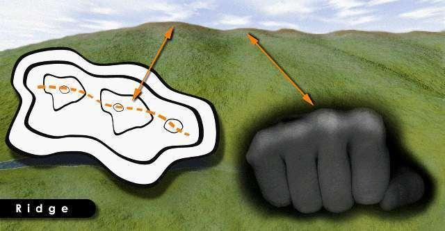
79 RIDGE

80 HILL


81 S A D D L E

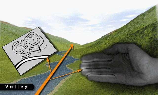
82 VALLEY
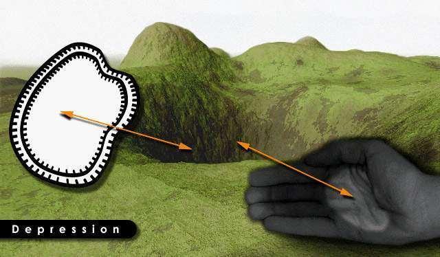
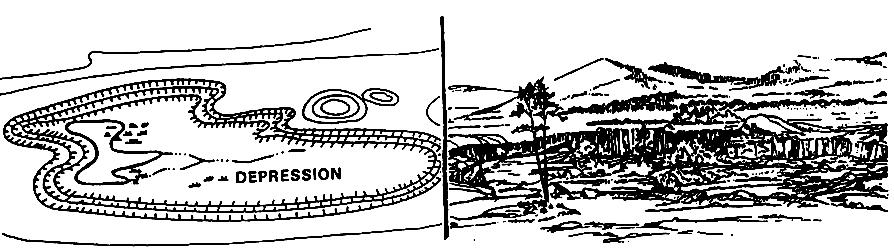
83 DEPRESSION
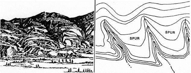
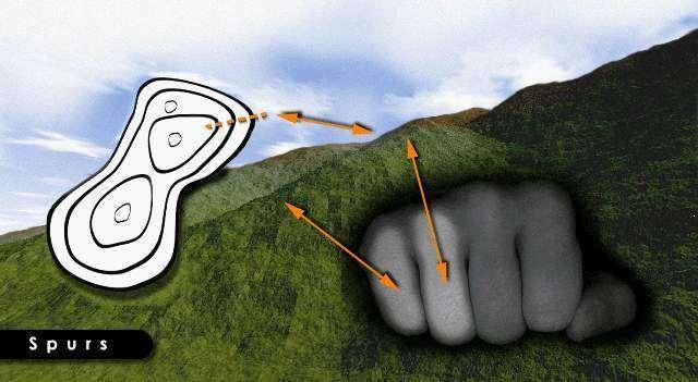
84 SPURS


85 DRAWS

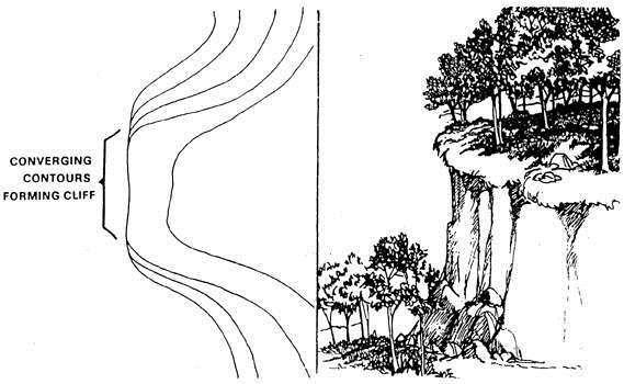
86 CLIFF


87 C U T F I L L

88 Terrain Features PART 1 Basic Land Navigation
89 Any Questions?

90 Map Information Direction EXPRESSING DIRECTION You need a way of expressing direction that is accurate, is adaptable to any part of the world, and has a common unit of measure. Directions are expressed as units of angular measure and direction implies a reference point. The common reference point for maps is True North, and map direction is figured in degrees from that point. Azimuths - The direction from one point to another point (either on the map or on the ground) is called an azimuth. Azimuths are given in degrees in a clockwise direction. Since there are 360 in a circle, an azimuth can be any number up to 360. East is 90, South is 180, West is 270, and North is 360. Maps are laid out with the top toward the top of the earth True North (geographic north) and map north. The side edges of the map are the only lines on the map guaranteed to run true north-south. The many north-south lines on a map give grid north. The compass needle points to magnetic north. Grid north and magnetic north usually have a few degrees difference. Neither points straight at the North Pole; that is called true north. With compass and map you can know what direction you are heading. PART 1 Basic Land Navigation

91 Map Information Direction THREE TYPES OF DIRECTION PART 1 Basic Land Navigation True North. A line from any point on the earth's surface to the north pole. Is represented by a star. Magnetic North. The direction to the north magnetic pole, as indicated by the north-seeking needle of a magnetic compass. The magnetic north is usually symbolized by a line ending with half of an arrowhead. Grid North. The north that is established by using the vertical grid lines on the map. Symbolized by the letters GN. Used for UTM grid by military and rescue teams for its accuracy and simplicity. G-M ANGLE. The angular difference between GN and MN. Why do we need to know all this? So that we can navigate using a map, the ground (we often forget the ground is important) and compass. You cannot follow a GN with a compass; nor can you plot a MN with a protractor. To assist you in making the conversion from MN to GN, and vice versa, a declination diagram is placed on the map margin. Remember the following. When using a map - use a protractor (next slides) to measure GRID Bearings. Do not use the compass magnetic needle. (unless map has MN Lines see Part 2 Intermediate Land Nav) When using the ground use a Compass to Measure MAGNETIC Bearings. With GN and G-M ANGLE you can find the MN. With MN and G-M ANGLE you can find the GN. G - M Angle = 24 Your direction of travel
92 Map Information Direction CONVERSION (three ways to remember) PART 1 Basic Land Navigation Left to Right Right to Left SUBTRACT ADD WEST to EAST is least ( - ) SUBTRACT EAST to WEST is best ( + ) ADD When MN is to the west (left) of GN MN to GN subtract G-M ANGLE GN to MN add G-M ANGLE MN GN MN GN When MN is to the east (right) of GN MN to GN add G-M ANGLE GN to MN subtract G-M ANGLE GN MN GN MN
93 Map Information Direction CONVERSION (example 1) PART 1 Basic Land Navigation HOW? Left to Right Right to Left SUBTRACT ADD G - M Angle = 24 Your direction of travel From ground to map. 1. You measure the bearing of a landmark on the ground with a compass. It is 49 MN. 2. The G-M ANGLE on the Map is So MN to GN SUBTRACT = 25 GN (Draw this on your map) From map to ground. 1. You measure the bearing of a point on the map with a protractor (next slides). It is 25 GN. 2. The G-M ANGLE on the Map is So GN to MN ADD = 49 MN (Put this on your compass)
 From map to ground. 1.")
94 Map Information Direction CONVERSION (example 2) PART 1 Basic Land Navigation HOW? Left to Right Right to Left SUBTRACT ADD G - M Angle 14-5 = 9 From ground to map. 1. You measure the bearing of a landmark on the ground with a compass. It is 322 MN. 2. The G-M ANGLE on the Map is 9 Your direction of travel 3. So MN to GN ADD = 331 GN (Draw this on your map) From map to ground. 1. You measure the bearing of a point on the map with a protractor (next slides). It is 331 GN. 2. The G-M ANGLE on the Map is 9 3. So GN to MN SUBTRACT = 322 MN (Put this on your compass)
95 Any Questions?
 by converting the protractor GN to a MN for the compass. 3.")
96 Map Information Direction PROTRACTOR PART 1 Basic Land Navigation 1. With a protractor the map does NOT have to be oriented. 2. It is used to calculate direction from map to ground (compass) by converting the protractor GN to a MN for the compass. 3. It is used for Plotting azimuths Plotting position Plotting UTM coordinates NOTE If you have MN LINES drawn on the map, you can align the protractor to a MN LINE, get the MN azimuth on the protractor and you DO NOT have to do any MN conversions. (see Part 2 Intermediate Land Nav)
 on the map. 2. With protractor aligned with GRID LINES drawn on the map and the center of the protractor aligned on your map position (you are here). 3.")
97 From map to ground. Map Information Direction PROTRACTOR (with a protractor the map does NOT have to be oriented) 1. You are in thick woods and cannot see any landmarks. But you decide to go to a hill (A) on the map. 2. With protractor aligned with GRID LINES drawn on the map and the center of the protractor aligned on your map position (you are here). 3. You see that the azimuth is 29 or 520 MILS. Next page for closer view 4. Convert this to MN azimuth and put this on your compass. PART 1 Basic Land Navigation A NOTE If you have MN LINES drawn on the map, align the protractor to a MN LINE, get the MN azimuth and you DON T have to do MN conversions. (See PART 2 Intermediate Land Navigation) you are here
 on the map. 2. With protractor aligned with GRID LINES drawn on the map and the center of the protractor aligned on your map position (you are here). 3.")
98 From map to ground. Map Information Direction PROTRACTOR (with a protractor the map does NOT have to be oriented) 1. You are in thick woods and cannot see any landmarks. But you decide to go to a hill (A) on the map. 2. With protractor aligned with GRID LINES drawn on the map and the center of the protractor aligned on your map position (you are here). 3. You see that the azimuth is 29 or 520 MILS. See previous page 4. Convert this to MN azimuth and put this on your compass. NOTE If you have MN LINES drawn on the map, align the protractor to a MN LINE, get the MN azimuth and you DON T have to do MN conversions. (See PART 2 Intermediate Land Navigation) PART 1 Basic Land Navigation
99 Any Questions?

100 Map Information - Direction Orienting the Map with the Landscape (MN and True North) TECHNIQUE # 1 (True North) 1. Identify several landmarks on the map and on the terrain. 2. Visually orient the map landmarks with the terrain landmarks. 3. The map is oriented to True North. TECHNIQUE # 2 (Magnetic North) With compass & map: 1. Lay the compass on the MN line on the map. 2. Rotate the map and compass together until the compass bearing reads 0 degrees Magnetic North (compass and MN line on the map are aligned / parallel). 3. The map is oriented to MN.


101 TECHNIQUE # 3 PART 1 Basic Land Navigation Map Information - Direction Orienting the Map with the Landscape (True North) 1. Find Magnetic Declination value in the map margin (bottom left corner), example East Place compass edge on edge of map North/South line with front of compass facing top of map. 3. Rotate map and compass together until North Arrow is 11.5 east of Black Index Line. Note: Black Index Line is aligned with ( = ), map is oriented to TRUE NORTH. MN 11.5 East of North correct for 1990 and moves easterly by 0.1 annually.

. 4.")
102 Map Information - Direction Orienting the Map with the Landscape (Magnetic North) TECHNIQUE # 4 when your position on the map is known. 1. Select a terrain feature on the ground that you can find on the map, example the HILL. 2. With the compass, sight the azimuth to the HILL(295 ) from your position ( ). 3. Align the compass edge through the HILL and your position ( ). 4. Rotate map and compass together until 295 is aligned with the Black Index Line. Map is oriented MN. HILL HILL
103 Any Questions?
104 Map Information - Distance The relationship between map and ground distance is the function of the bar scale. The bar scale looks like a small ruler and usually has 3 to 4 bar scales; feet, miles, meters, and kilometers. The ability to determine distance on a map, as well as on the earth s surface, is an important factor in planning and executing safe, practical routes. The map scale of 1:xx,xxx means that one unit of measure on the map is equal to xx,xxx units of the same measure on the ground. Example A map scale of 1:25,000 means that one unit of measure on the map is equal to 25,000 units of the same measure on the ground. On map 1 inch = 25,000 inches (2083 feet, 694 yards) on the ground. On map 1 cm = 25,000 cm (250 meters, ¼ kilometer) on the ground. A map scale of 1:100,000 means that one unit of measure on the map is equal to 100,000 units of the same measure on the ground. On map 1 inch = 100,000 inches (8333 feet, 2778 yards, 1¾ miles) on the ground. On map 1 cm = 100,000 cm (1000 meters, 1 kilometer) on the ground. A map scale of 1:500,000 means that one unit of measure on the map is equal to 500,000 units of the same measure on the ground. On map 1 inch = 500,000 inches (41667 feet, yards, 8 miles) on the ground. On map 1 cm = 500,000 cm (5000 meters, 5 kilometer) on the ground. PART 1 Basic Land Navigation
 on the ground. On map 1 cm = 25,000 cm (250 meters, ¼ kilometer) on the ground.")
105 Map Information - Distance EXAMPLE - a map scale of 1:25,000 means that one unit of measure on the map is equal to 25,000 units of the same measure on the ground. On map 1 inch = 25,000 inches (2083 feet, 694 yards) on the ground. On map 1 cm = 25,000 cm (250 meters, ¼ kilometer) on the ground. Example below shows the navigator using centimeters (cm) as a measurement, therefore the map 10cm measurement is equal to 250,000cm on the ground. (3.94 inches map = 98,500 inches ground) 10cm x 25,000 = 250,000cm (2.5 Km) 3.94in x 25,000 = 98,500in (1.55 miles) B A B A
106 Map Information - Position Finding one s position on a map in the usual sense, such as at the intersection of two compass bearings, is more a matter of compass technique than of map reading skills... BUT... It is possible to locate your POSITION on a map without a compass, by land feature and map association. It is IMPOSSIBLE TO BE TOTALLY LOST. Finding your location is a process of narrowing down the options until you can determine a point on a map. By determining the lay of the land and finding prominent features, then relating them to your map, the narrowing-down process will not take long. Landmarks can be anything that you recognize as being on the map. Classically these are hill tops, but you can use the intersection of two roads, a building such as a power grid sub-station, the abrupt edge of a ridge, the edge of an island, the bend in a trail, anything that you can recognize as being on the map and that you can see. There is a second dimension to establishing position which does depend on map reading skills. This is the vertical dimension. On a map it is referred to as relief. Knowledge of the relief of an area is extremely important to a wilderness navigator. The most graphic technique ever devised to show relief information is the contour line. PART 1 Basic Land Navigation If you were to walk a contour line you would never go down hill and never up hill, and eventually you would arrive back where you started. Navigation is not about finding yourself after you are lost (although that s what happens sometimes); navigation is about keeping track of your POSITION as you move away from a known point. As you move you have to remain cognizant of the terrain you are leaving, of the terrain you are passing, and of the terrain that is coming up.


107 Map Information - Identification The identification of significant features, both natural and man-made, is partly a matter of knowing the language of maps. One category of map language is lines. In addition to showing contour relief, lines are used to portray roads, trails, railroads, power lines, and drainage features. Another category of map language is composed of various picture symbols. A third part of map language is color. PART 1 Basic Land Navigation If part of identification is in knowing the language of maps, the rest is a problem of interpretation. What is the relationship among certain lines, symbols, and colors? Reading contour lines is literally reading between the lines. Contour lines represent the shape of the terrain only at specified intervals. The user must be aware that what lies between may be quite different. There could be rugged terrain, vertical bluffs, or deep ravines that might not be shown. A river may be drawn some what straight on a map, but the terrains actual river meanders, with many curves, turns, and with wide and narrow banks. What a topographic map shows is as accurate as possible, BUT can give you a false sense of what you might mentally think what is ahead of you and what actually is shown on an aerial photo map and actual land features. (see next slides)

108 Map Information - Identification CONTOUR LINES Contour Lines on a map Do not show everything. Scan the Landscape, read between the lines.
109 Any Questions?


110 Map Information Identification What a Topo map, Aerophoto map, And actual Land features show LAND AERIAL PHOTO TOPO MAP


111 Map Information Identification What a Topo map and actual Land features show


112 Map Information Identification What a Topo map and actual Land features show

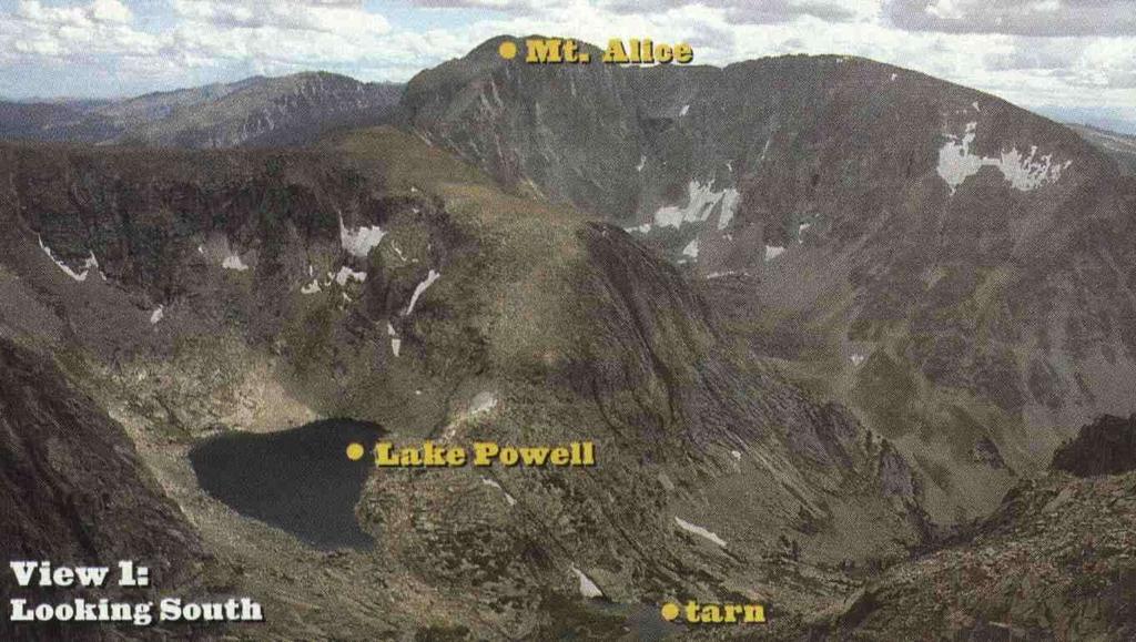
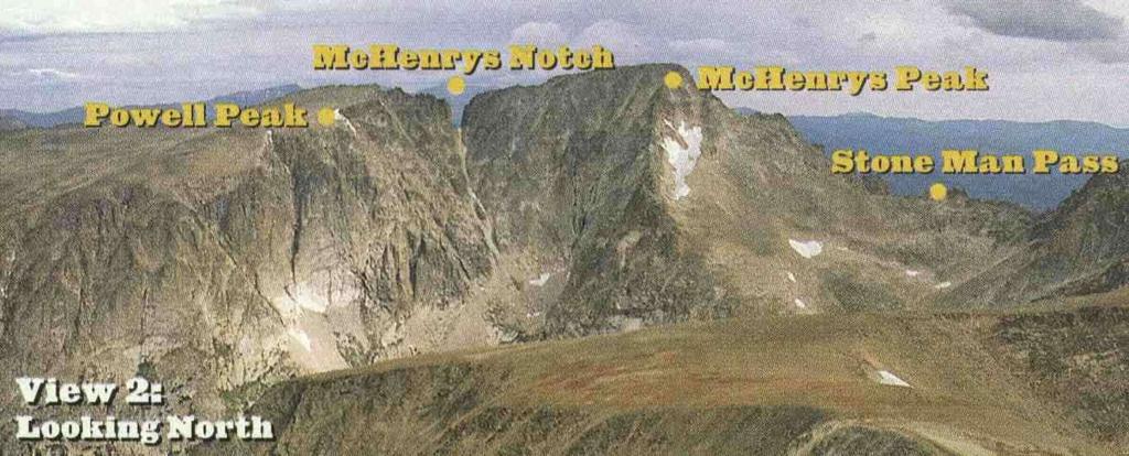
113 View 1 PART 1 Basic Land Navigation Map Information Identification What a Topo map and actual Land features show Compare the next five slides with this map, to get view point perspective of what you see on this map and what you see on the landscape in front of you. View 2
114
115

116 Map Information Identification What a Topo map and actual Land features show Note: here the map is turned upside down so you can get a better perspective View 1 View 1
117 Map Information Identification What a Topo map and actual Land features show View 2 View 2
118 View 1 PART 1 Basic Land Navigation View 2
119 Any Questions?


120 Maps should be correctly folded. Map Folding and Map Care PART 1 Basic Land Navigation Maps should be folded to make them small enough to be carried and still be available for use without having to unfold them entirely. After a map has been folded it should be placed in a folder for protection. This will prevent the corners and edges of the map from wearing out and tearing easily when opened. It is hard to navigate accurately with a dirty, grimy, wet or damaged map. Take care of your map and it will take care of you. Most maps are printed on paper and require protection from water, mud, weather, and tearing. Whenever possible, a map should be carried in a waterproof packet to prolong its life. Waterproofing maps. All members of the group should know the map s location at all times. Marking a map. If it is necessary to mark a map, use light lines so that they may be erased without smearing or smudging. If the margins of the map must be trimmed note any marginal information which may be needed, such as grid data or magnetic declination data, on the back of the map. Special care should be taken of a map that is being used in any situation, especially in a small group; the mission may depend on that map.


121 WELCOME TO LAND NAVIGATION CLASS Map Folding Technique # 3 After a map has been folded, it should be pasted in a folder for protection. Apply adhesive to the back of the segments corresponding to A, F, L, and Q Technique # 1 NOTE: It is suggested that before attempting to cut and fold a map in the manner illustrated below (Technique #3), make a practice cut and fold with a piece of paper. Technique # 2
122 Any Questions?
123 Note: Prior to being issued any training *equipment, you will be required to sign a statement of liability agreeing to pay for anything you damage or lose. All items will be inspected and inventoried prior to your signature and at the end of the training day too. If you do not intend to sign this statement, then you may be denied training. * You may use your own equipment.

124 TESTING Now it is time for the following... Written exam Hands-on / Outdoors exam
125 THE END OF LAND NAVIGATION PRESENTATION PART 1
USING THE MILITARY LENSATIC COMPASS
 USING THE MILITARY LENSATIC COMPASS WARNING This presentation is intended as a quick summary, and not a comprehensive resource. If you want to learn Land Navigation in detail, either buy a book; or get
USING THE MILITARY LENSATIC COMPASS
 USING THE MILITARY LENSATIC COMPASS WARNING This presentation is intended as a quick summary, and not a comprehensive resource. If you want to learn Land Navigation in detail, either buy a book; or get
USING THE MILITARY LENSATIC COMPASS
 USING THE MILITARY LENSATIC COMPASS WARNING This presentation is intended as a quick summary, and not a comprehensive resource. If you want to learn Land Navigation in detail, either buy a book; or get
USING THE MILITARY LENSATIC COMPASS
 USING THE MILITARY LENSATIC COMPASS WARNING This presentation is intended as a quick summary, and not a comprehensive resource. If you want to learn Land Navigation in detail, either buy a book; or get
USING THE MILITARY LENSATIC COMPASS
 USING THE MILITARY LENSATIC COMPASS WARNING This presentation is intended as a quick summary, and not a comprehensive resource. If you want to learn Land Navigation in detail, either buy a book; or get
Land Navigation at Nevada Youth Range Camp
 Curriculum 15-03 Land Navigation at Nevada Youth Range Camp Stephen S. Foster, Pershing County Extension Educator Sherm Swanson, Riparian and Rangeland Specialist This curriculum is used at Nevada Youth
USING THE MILITARY LENSATIC COMPASS
 USING THE MILITARY LENSATIC COMPASS WARNING This presentation is intended as a quick summary, and not a comprehensive resource. If you want to learn Land Navigation in detail, either buy a book; or get
USING THE MILITARY LENSATIC COMPASS
 USING THE MILITARY LENSATIC COMPASS WARNING This presentation is intended as a quick summary, and not a comprehensive resource. If you want to learn Land Navigation in detail, either buy a book; or get
LENSATIC COMPASS W140009XQ STUDENT HANDOUT
 B170249XQ UNITED STATES MARINE CORPS THE BASIC SCHOOL MARINE CORPS TRAINING COMMAND CAMP BARRETT, VIRGINIA 22134-5019 LENSATIC COMPASS W140009XQ STUDENT HANDOUT Warrant Officer Basic Course Introduction
LAND NAVIGATION: TOOLS AND TECHNIQUES
 TOOLS AND TECHNIQUES B1415 UNITED STATES MARINE CORPS Basic Officer Course The Basic School Marine Corps Combat Development Command Quantico, Virginia 22134-5019 B1415 LAND NAVIGATION: TOOLS AND TECHNIQUES
ANSWER SHEET PART 4 EXPERT LAND NAVIGATION
 ANSWER SHEET PART 4 EXPERT LAND NAVIGATION 1. Knowing these four basic skills, it is impossible to be totally lost; what are they? a. Track Present Location / Determine Distance / Sense of Direction /
TEST EXAM PART 3 ADVANCE LAND NAVIGATION
 NAME DATE TEST EXAM PART 3 ADVANCE LAND NAVIGATION 1. Knowing these four basic skills, it is impossible to be totally lost; what are they? a. Track Present Location / Determine Distance / Sense of Direction
Chapter 6 - The Compass Upon completion of this chapter, you will be able to:
 Chapter 6 - The Compass Upon completion of this chapter, you will be able to: Explain the use of the 360 degree system in defining direction. Identify the parts of a compass, i.e.: - base plate - magnetic
FIRST AID (Seven Life-Savings Steps)
") FIRST AID (Seven Life-Savings Steps) Ensure area is safe before approaching victim. 1. Check for responsiveness. a. Ask in a loud, but calm voice, "Are you okay?" b. Gently shake or tap the victim on the
FIRST AID (Seven Life-Savings Steps) Ensure area is safe before approaching victim. 1. Check for responsiveness. a. Ask in a loud, but calm voice, "Are you okay?" b. Gently shake or tap the victim on the
USING THE MILITARY LENSATIC COMPASS
 USING THE MILITARY LENSATIC COMPASS WARNING This presentation is intended as a quick summary, and not a comprehensive resource. If you want to learn Land Navigation in detail, either buy a book; or get
ORIENTEERING LESSON 1: ORIENTEERING
 ORIENTEERING LESSON 1: ORIENTEERING PURPOSE This lesson will introduce you to orienteering, its techniques and terminology, as well as the various types of orienteering courses. In addition, many of the
MOUNTED LAND NAVIGATION
 CHAPTER 12 MOUNTED LAND NAVIGATION A vehicle commander should be able to navigate from one point on the ground to another with or without a compass. If separated from his unit and given an azimuth and
Navigation Using Compass
 Navigation Using Compass Updated January 2015 Albi Sole 0 Outdoor Council of Canada / Conseil canadien de plein air Published by The Outdoor Council of Canada / Conseil canadien de plein air KNA-101, 2500
Scout Skills Compass INFORMATION SHEET
 Scout Skills Compass 0845 300 1818 INFORMATION SHEET A compass is an instrument with a magnetised needle which points to (magnetic) north and is therefore used for determining direction. They come in different
MAPPING DESCRIPTIONS AND DRAFTING PARCEL BOUNDARIES FOR CADASTRAL MAPPING
 MAPPING DESCRIPTIONS AND DRAFTING PARCEL BOUNDARIES FOR CADASTRAL MAPPING Chapter 6 2015 Cadastral Mapping Manual 6-0 Another method of describing land, aside from the fractional section method, is called
Homework 2a Bathymetric Charts [based on the Chauffe & Jefferies (2007)]
![Homework 2a Bathymetric Charts [based on the Chauffe & Jefferies (2007)]](/thumbs/73/69074241.jpg "Homework 2a Bathymetric Charts [based on the Chauffe & Jefferies (2007)]") 14 August 2008 MAR 110 HW-2a: ex1bathymetric Charts 1 2-1. BATHYMETRIC CHARTS Homework 2a Bathymetric Charts [based on the Chauffe & Jefferies (2007)] Nautical charts are maps of a region of the ocean
14 August 2008 MAR 110 HW-2a: ex1bathymetric Charts 1 2-1. BATHYMETRIC CHARTS Homework 2a Bathymetric Charts [based on the Chauffe & Jefferies (2007)] Nautical charts are maps of a region of the ocean
Get Your Bearings.
 Get Your Bearings A compass tells you in what direction you are headed relative to magnetic north. You can combine use of a compass with pacing to find your way across country (where there may not be any
Choosing a North Reference
 Choosing a North Reference On your Map For your Compass For your GPS! When the north references are different, you will need to do conversions as you move bearings between your map, compass, and GPS. North
Homework 2 Bathymetric Charts [based on the Chauffe & Jefferies (2007)]
![Homework 2 Bathymetric Charts [based on the Chauffe & Jefferies (2007)]](/thumbs/75/72427079.jpg "Homework 2 Bathymetric Charts [based on the Chauffe & Jefferies (2007)]") 1 MAR 110 HW-2 - Bathy Charts Homework 2 Bathymetric Charts [based on the Chauffe & Jefferies (2007)] 2-1. BATHYMETRIC CHARTS Bathymetric charts are maps of a region of the ocean used primarily for navigation
1 MAR 110 HW-2 - Bathy Charts Homework 2 Bathymetric Charts [based on the Chauffe & Jefferies (2007)] 2-1. BATHYMETRIC CHARTS Bathymetric charts are maps of a region of the ocean used primarily for navigation
Lat. & Long. Review. Angular distance N or S of equator Equator = 0º Must indicate N or S North pole = 90º N
 Navigation Part 2 1 Lesson Objectives Understand how a ships compass works and how it is used for navigation Measure distances on nautical charts Plot a course on a nautical chart Correct course headings
The activity is designed to take about an hour start to finish.
 Troop 606 Orienteering Course Overview This Orienteering Course is designed to help Scouts satisfy requirements 4a and 4b for the First Class Rank. These requirements are as follows (as of 2017): 4a. Using
EXPERIMENT 10: MAGNETIC FIELDS
 LAB SECTION: NAME: EXPERIMENT 10: MAGNETIC FIELDS Introduction: In this lab, you will use compasses to investigate the magnetic field of a bar magnet and the magnetic field of a long straight current.
Advanced Land Navigation
 California Cadet Corps Curriculum on Map Reading Advanced Land Navigation LEADERS KNOW THE WAY 5/22/2017 Advanced Land Navigation Agenda C1. Advanced Map Reading Techniques C2. Land Navigation C3. Designing
What is the distance from Minneapolis to Duluth, computed via trunk highways? 155 miles (1 point) see chart at top of map
 see chart at top of map") Gopher Science Olympiad Invitational Road Scholar 2018 Answer Key; 60 points total MN State Highway map (15 points) What is the scale of this map? 1/16 inch = 1 mile (1 point for number, 1 point for units)
Gopher Science Olympiad Invitational Road Scholar 2018 Answer Key; 60 points total MN State Highway map (15 points) What is the scale of this map? 1/16 inch = 1 mile (1 point for number, 1 point for units)
Basic Chartwork. Necessary Tools. Navigation is the one science in which no margin whatever is left for the faker. - Felix Riesenberg
 Page 1 of 14 www.bananawind.us Navigation is the one science in which no margin whatever is left for the faker. - Felix Riesenberg Basic Chartwork You wouldn't want to attempt open ocean sailing using
TO RECEIVE the most benefit from a
 Using Surveying Equipment TO RECEIVE the most benefit from a tool, it must be used properly. In addition, it must be well maintained. In most cases, the user will need some instruction and training regarding
Installation Instructions Topo Ceiling System
 Topo Ceiling Page 1 of 12 Before beginning installation of the TOPO Ceiling, check the enclosed bill of materials to ensure that all parts are present and undamaged. Read all installation instructions
North, South, East & West Environmental Education Lesson Plan Edwards Camp and Conference Center
 North, South, East & West Environmental Education Lesson Plan Edwards Camp and Conference Center Updated 3/2011 SUMMARY In the North, South, East & West lesson the students will familiarize themselves
Chartwork Learn the basics for position fixing using a number of techniques and a simple equation for speed, distance and time.
 Chartwork Learn the basics for position fixing using a number of techniques and a simple equation for speed, distance and time. Chartwork Chartwork Tools Accurate chart work is the basis for good navigation.
Exercise 2-3. Flow Rate and Velocity EXERCISE OBJECTIVE C C C
 Exercise 2-3 EXERCISE OBJECTIVE C C C To describe the operation of a flow control valve; To establish the relationship between flow rate and velocity; To operate meter-in, meter-out, and bypass flow control
 Automatic level / Optical level / Dumpy Level Instruction Manual www.level1lasers.com.au Contents Introduction 2 Diagram 3 Operation Instruction 4 Calibration Self-Check 5 Technical Specifications 6 Maintenance
Navigating Barker Inlet: some exercises
 Introduction The Torrens Island and nvirons map A few things have changed since the Torrens Island and nvirons (TI) map was published. The most obvious from Barker Inlet is the new silo and bulk grain
METHODS EMPLOYED IN LOCATING SOUNDINGS
 METHODS EMPLOYED IN LOCATING SOUNDINGS The soundings are located with reference to the shore traverse by observations made (i) entirely from the boat, (ii) entirely from the shore or (iii) from both. The
Compass Use. Objective To turn accurately onto and maintain compass headings, compensating for known errors in the magnetic compass.
 Instrument Flying Compass Use The magnetic compass is the primary navigation aid for most light aeroplanes. It is the only instrument in most light aeroplanes that indicates the correct heading. The directional
ILLINOIS ARMY NATIONAL GUARD Sparta Training Area 715 Industrial Drive Sparta, IL 62286
 ILLINOIS ARMY NATIONAL GUARD Sparta Training Area 715 Industrial Drive Sparta, IL 62286 103 Land Navigation Course Ph. (309) 567-6810 INDEX Chapter 1 GENERAL Page Guidance for OIC/Test Administrator 2-4
Using Surveying Equipment
 Lesson A2 2: Using Surveying Equipment Agricultural Mechanics and Technology Cluster Illinois Agricultural Education Core Curriculum Unit A. Mechanical Systems and Technology Problem Area 2. Soil and Environmental
Walk - Run Activity --An S and P Wave Travel Time Simulation ( S minus P Earthquake Location Method)
") Walk - Run Activity --An S and P Wave Travel Time Simulation ( S minus P Earthquake Location Method) L. W. Braile and S. J. Braile (June, 2000) braile@purdue.edu http://web.ics.purdue.edu/~braile Walk
Walk - Run Activity --An S and P Wave Travel Time Simulation ( S minus P Earthquake Location Method) L. W. Braile and S. J. Braile (June, 2000) braile@purdue.edu http://web.ics.purdue.edu/~braile Walk
UNITED STATES MARINE CORPS WEAPONS TRAINING BATTALION MARINE CORPS COMBAT DEVELOPMENT COMMAND QUANTICO, VIRGINIA
 UNITED STATES MARINE CORPS WEAPONS TRAINING BATTALION MARINE CORPS COMBAT DEVELOPMENT COMMAND QUANTICO, VIRGINIA 22134-5040 DETAILED INSTRUCTOR GUIDE LESSON TITLE DATA BOOK COURSE TITLE ANNUAL RIFLE TRAINING
Surveying Fundamentals and Practices, 5/e
 Online Instructor s Manual to accompany Surveying Fundamentals and Practices, 5/e Jerry Nathanson Michael T. Lanzafama Philip Kissam Upper Saddle River, New Jersey Columbus, Ohio Copyright 2010 by Pearson
FM APPENDIX F ORIENTEERING
 APPENDIX F ORIENTEERING What is orienteering? Orienteering is a competitive form of land navigation. It is for all ages and degrees of fitness and skill. It provides the suspense and excitement of a treasure
3.6 Magnetic surveys. Sampling Time variations Gradiometers Processing. Sampling
 3.6 Magnetic surveys Sampling Time variations Gradiometers Processing Sampling Magnetic surveys can be taken along profiles or, more often, on a grid. The data for a grid is usually taken with fairly frequent
OSSA MINIMUM SEARCH & RESCUE CERTIFICATION / QUALIFICATION CRITERIA BASIC LEVEL
 OSSA MINIMUM SEARCH & RESCUE CERTIFICATION / QUALIFICATION CRITERIA BASIC LEVEL Chapter 1 LEGAL ISSUES Through written evaluation the applicant will demonstrate knowledge of the legal issues involved in
UNITED STATES MARINE CORPS WEAPONS TRAINING BATTALION MARINE CORPS COMBAT DEVELOPMENT COMMAND QUANTICO, VIRGINIA
 UNITED STATES MARINE CORPS WEAPONS TRAINING BATTALION MARINE CORPS COMBAT DEVELOPMENT COMMAND QUANTICO, VIRGINIA 22134-5040 DETAILED INSTRUCTOR GUIDE LESSON TITLE RIFLE ZEROING COURSE TITLE DIVISION MATCH
OPERATIONS SEAFARER CERTIFICATION GUIDANCE NOTE SA MARITIME QUALIFICATIONS CODE. Deck: Chart Work
 Page 1 of 6 Compiled by Approved by Chief Examiner Syllabus Committee: 26 February 2013 OPERATIONS SEAFARER CERTIFICATION GUIDANCE NOTE SA MARITIME QUALIFICATIONS CODE Deck: Chart Work Page 2 of 6 COLUMN
Instructions for using the PRECISION DIGITAL PITCH GAUGE 2008, Precision Analytical Instruments, Inc. Congratulations!
 10857 Millington Court Blue Ash, OH 45242 513-984-1600 (voice), 513-984-4090 (fax) email Doug@ToolsForAnalysis.com Instructions for using the PRECISION DIGITAL PITCH GAUGE 2008, Precision Analytical Instruments,
USING THE GPS TO WALK TRANSECTS. by Robert L. Hafey
 USING THE GPS TO WALK TRANSECTS by Robert L. Hafey This paper will provide specific instructions or suggestions on how to setup the GPS to facilitate transect walking for field surveys. Systematic field
Surveying & Measurement. Distance Measurement
 Surveying & Measurement Distance Measurement Introduction One of the most fundamental surveying operations is the measurement of horizontal distance between two points on the surface of the earth. There
FM CHAPTER 11 TERRAIN ASSOCIATION
 CHAPTER 11 TERRAIN ASSOCIATION Failure to make use of the vast amounts of information presented by the map and available to the eye on the ground reduces the chances for success in land navigation. The
ILLINOIS ARMY NATIONAL GUARD Marseilles Training Area 1700 Army Road Marseilles, IL
 ILLINOIS ARMY NATIONAL GUARD Marseilles Training Area 1700 Army Road Marseilles, IL 61341-9535 106 Land Navigation Course Ph. (815)795-5701 INDEX Chapter 1 GENERAL Page Guidance for OIC/Test Administrator
Homework 2b: Bathymetric Profiles [based on the Chauffe & Jefferies (2007)]
![Homework 2b: Bathymetric Profiles [based on the Chauffe & Jefferies (2007)]](/thumbs/77/75183244.jpg "Homework 2b: Bathymetric Profiles [based on the Chauffe & Jefferies (2007)]") 14 August 2008 HW-2b: - Bathymetric Profiles 1 2-5. BATHYMETRIC PROFILES Homework 2b: Bathymetric Profiles [based on the Chauffe & Jefferies (2007)] A bathymetric profile provides a "skyline view" of the
14 August 2008 HW-2b: - Bathymetric Profiles 1 2-5. BATHYMETRIC PROFILES Homework 2b: Bathymetric Profiles [based on the Chauffe & Jefferies (2007)] A bathymetric profile provides a "skyline view" of the
Certified Accuracy. Ring Force Gauge. Models and Capacities Available. Design and Principle of Operation
 Certified Accuracy Ring Force Gauge The accurate measurement of mechanical forces is required in hundreds of applications from a simple weighing procedure to the calibration of testing machines and load
BENDING CONDUIT / TUBING USING HAND BENDERS
 www.learnnec.net 408-866 - 7890 Electrical Code training and consultation based on NEC 2008 BENDING CONDUIT / TUBING USING HAND BENDERS The ability to bend conduit and tubing is a requirement for all electricians.
Installation, Compensation and Maintenance Instructions for. RITCHIE Compasses. Made In U.S.A
 Installation, Compensation and Maintenance Instructions for RITCHIE Compasses Made In U.S.A All Magnetic Compasses are vulnerable to magnetic interference, which will produce errors, called deviation.
Transportation Engineering II Dr. Rajat Rastogi Department of Civil Engineering Indian Institute of Technology - Roorkee
 Transportation Engineering II Dr. Rajat Rastogi Department of Civil Engineering Indian Institute of Technology - Roorkee Lecture 31 Runway Orientation Dear students, I welcome you back to the lecture series
1. NUMBERED CONTROL DESCRIPTIONS
 ORIENTEERING AT BRIGHTON WOODS There are eight numbered posts (controls) for the orienteering course at Brighton Woods. Each has a number that corresponds to the number on the Brighton Woods Orienteering
Trade of Metal Fabrication. Module 1: Basic Fabrication Unit 3: Tools and Equipment Phase 2
 Trade of Metal Fabrication Module 1: Basic Fabrication Unit 3: Tools and Equipment Phase 2 Table of Contents List of Figures... 3 List of Tables... 4 Document Release History... 5 Module 1 Basic Fabrication...
DX2/DXX Operating Instructions
 CHECK LINE BY ELECTROMATIC DX2/DXX Operating Instructions CHECK LINE INSTRUMENTS ELECTROMATIC E Q U I P M E N T C O., I N C. 600 Oakland Ave., Cedarhurst, NY 11516 U.S.A. TEL: 516-295-4300 FAX: 516-295-4399
Cover Page for Lab Report Group Portion. Head Losses in Pipes
 Cover Page for Lab Report Group Portion Head Losses in Pipes Prepared by Professor J. M. Cimbala, Penn State University Latest revision: 02 February 2012 Name 1: Name 2: Name 3: [Name 4: ] Date: Section
Navigation & Orienteering: Pre- Test
 Name: Class: Answer Key Date: Page 1 of 7 Navigation & Orienteering: Pre- Test There are three sections: Multiple Choice, True/False, and Short Answer. For the multiple choice, please select the BEST answer
Viva TPS. TS11/15 Total Stations Check and Adjust Procedure. October Summary
 Viva TPS October 2010 TS11/15 Total Stations Summary Leica builds total stations to the highest quality and calibrates each instrument before it leaves the Factory. After the instrument is shipped or used
SUUNTO COMBOS AND MECHANICAL INSTRUMENTS
 en SUUNTO COMBOS AND MECHANICAL INSTRUMENTS INSTRUCTION MANUAL Combo Consoles I Console Compasses CB-71/STD and CB-71/DS Depth Gauge SM-16 I Pressure Gauge SM-36 SUUNTO Combo Consoles Introduction The
1 SafeClaw Anchorage Connectors
 Operations and Instruction Manual Model #4077 Portable Concrete Anchorage Connector ANSI Z359.1 10,000 lbs / 44kn OHSA 1910.66 & 1926.502 Effective: 01/2012 Expires: 01/2022 IM-0050 REVA 1 SafeClaw Anchorage
Field Manual Condensed (FMC) Machine Gun Tactics and Employment
 Machine Gun Tactics and Employment") Field Manual Condensed (FMC) 23-22 Machine Gun Tactics and Employment Falcon, United Operations http://www.unitedoperations.net/ FIELD MANUAL CONDENSED (FMC) 23-22 1 Page intentionally left blank. 2 FIELD
Field Manual Condensed (FMC) 23-22 Machine Gun Tactics and Employment Falcon, United Operations http://www.unitedoperations.net/ FIELD MANUAL CONDENSED (FMC) 23-22 1 Page intentionally left blank. 2 FIELD
Ambient Weather GL150-B Nautical Barometer User Manual
 Ambient Weather GL150-B Nautical Barometer User Manual Table of Contents 1. Introduction... 2 2. Care and Cleaning... 2 3. Installation... 2 4. Barometer Operation... 3 3.1 How the aneroid barometer works...
LESSON 4: THE FIRST TARGET POSITION - STANDING
 LESSON 4: THE FIRST TARGET POSITION - STANDING PURPOSE This lesson introduces you to the first target position, which is the standing position. the type of clothes that are used in school-age sporter class
Section D 4: Introduction to plotting
 Boating Course Student s Notes Section 4 Section 4: Introduction to plotting 4.1 General If a boat is being conned through a winding channel where there is a great deal of boat traffic, the helmsman is
3/4 SafeClaw Anchorage Connectors
 Operations and Instruction Manual Model #4075 Portable Concrete Anchorage Connector ANSI Z359.1-07 5,000 lbs / 22kn OHSA 1910.66 & 1926.502 Effective: 01/2012 Expires: 01/2022 IM-0049 REVA 3/4 SafeClaw
Wade Reynolds 1 Frank Young 1,2 Peter Gibbings 1,2. University of Southern Queensland Toowoomba 4350 AUSTRALIA
 A Comparison of Methods for Mapping Golf Greens Wade Reynolds 1 Frank Young 1,2 Peter Gibbings 1,2 1 Faculty of Engineering and Surveying 2 Australian Centre for Sustainable Catchments University of Southern
Besides the reported poor performance of the candidates there were a number of mistakes observed on the assessment tool itself outlined as follows:
 MATHEMATICS (309/1) REPORT The 2013 Mathematics (309/1) paper was of average standard. The paper covered a wide range of the syllabus. It was neither gender bias nor culture bias. It did not have language
Zero an M16A2 Rifle. From Army Manual STP 21-1-SMCT "Soldier's Manual Of Common Tasks"
 Zero an M16A2 Rifle From Army Manual STP 21-1-SMCT "Soldier's Manual Of Common Tasks" *CONDITIONS* On a 25-meter range, given an M16A2 rifle, 18 rounds of 556-mm ammunition, a 300- meter zero target, and
EXPERIMENT 1 BASIC LABORATORY TECHNIQUES AND TREATMENT OF DATA MEASUREMENTS
 EXPERIMENT 1 BASIC LABORATORY TECHNIQUES AND TREATMENT OF DATA MEASUREMENTS Introduction In the following experiment you will be required to use a Bunsen burner, balance, a pipet, graduated cylinder, flask,
The Fundamentals of Putting
 The Fundamentals of Putting Episode 1 - Setup and Aiming A proper setup position is a prerequisite of a good putt. Setup includes body posture, gripping the putter, alignment of body relative to the ball
Adventure Racing/Navigation 101
 Adventure Racing/Navigation 101 Adventure Racing (AR) is a multi-sport, team event in which racers navigate their way from checkpoint to checkpoint using a map, compass and route strategy within a set
Land Survey. 1. Pick the two points (A and B) that you would like to measure. You must be able to see clearly between the two points.
 that you would like to measure. You must be able to see clearly between the two points.") Land Survey William Clark did most of the surveying and mapping for the Lewis and Clark Expedition. When he needed to measure the distance between two points that were far apart, he used a method called
Land Survey William Clark did most of the surveying and mapping for the Lewis and Clark Expedition. When he needed to measure the distance between two points that were far apart, he used a method called
PLACEMENT OF SIGNS RECOMMENDED PRACTICES SUB-SECTION
 Page 1 of 6 RECOMMENDED PRACTICES PART SECTION SUB-SECTION HIGHWAY SIGNS GENERAL General Proper positioning of signs is an important element in the overall control of traffic within a roadway network.
International Civil Aviation Organization
 International Civil Aviation Organization WORKING PAPER 11 August 2015 ENGLISH ONLY Agenda item 4 ICAO/IMO JOINT WORKING GROUP ON HARMONIZATION OF AERONAUTICAL AND MARITIME SEARCH AND RESCUE (ICAO/IMO
DISTANCE MEASUREMENT
 DISTANCE MEASUREMENT Distance Definition: The horizontal distance between two points. In ground surveys even though many angles may be read, the length of at least one line must be measured to supplement
RULES FOR SAFE FIRING:
 EN THIS AIRGUN IS INTENDED FOR USE BY THOSE YEARS OF AGE OR OLDER. ADULT SUPERVISION REQUIRED. SOFT-AIR-PISTOL PPK/S BLOW BACK RULES FOR SAFE FIRING:. Get to know the single parts of your new soft-air
COMMON TRAINING PROFICIENCY LEVEL FOUR INSTRUCTIONAL GUIDE SECTION 3 EO C SCORE AIR RIFLE MARKSMANSHIP TARGETS PREPARATION
 COMMON TRAINING PROFICIENCY LEVEL FOUR INSTRUCTIONAL GUIDE SECTION 3 EO C406.02 SCORE AIR RIFLE MARKSMANSHIP TARGETS Total Time: 30 min PREPARATION PRE-LESSON INSTRUCTIONS Resources needed for the delivery
UNITED STATES MARINE CORPS WEAPONS TRAINING BATTALION MARINE CORPS COMBAT DEVELOPMENT COMMAND QUANTICO, VIRGINIA
 UNITED STATES MARINE CORPS WEAPONS TRAINING BATTALION MARINE CORPS COMBAT DEVELOPMENT COMMAND QUANTICO, VIRGINIA 22134-5040 DETAILED INSTRUCTOR GUIDE LESSON TITLE RIFLE SITTING POSITION COURSE TITLE ANNUAL
LAB 7. ROTATION. 7.1 Problem. 7.2 Equipment. 7.3 Activities
 LAB 7. ROTATION 7.1 Problem How are quantities of rotational motion defined? What sort of influence changes an object s rotation? How do the quantities of rotational motion operate? 7.2 Equipment plumb
TRAINING LAB BLOOD AS EVIDENCE BLOOD DROPS FALLING AT AN ANGLE NAME
 TRAINING LAB BLOOD AS EVIDENCE BLOOD DROPS FALLING AT AN ANGLE NAME Background: You just completed studying the behavior of passive blood drops that drip straight down from a wound, but not all blood drops
Direction-of-travel arrow. Line up the magnetic arrow and orienting arrow. bearing.
 Orienteering Direction-of-travel arrow Line up the magnetic arrow and orienting arrow. Read bearing. How to Use This Pamphlet The secret to successfully earning a merit badge is for you to use both the
Model Visit our website at:
 6 DIAL Fractional CALIPER Model 92437 Set up And Operating Instructions Visit our website at: http://www.harborfreight.com Read this material before using this product. Failure to do so can result in serious
ARCHERY & SCOUTING. PRESENTATION POINTS: Equipment & Safety Personal Safety Facility Safety 10 steps to good shooting
 ARCHERY & SCOUTING PRESENTATION POINTS: Equipment & Safety Personal Safety Facility Safety 10 steps to good shooting Kathleen Millar, CAE, OCT NCCP Level 4 Coach EQUIPMENT SAFETY Stringing & Unstringing
! Warning, refer to accompanying documents.
 About this Manual To the best of our knowledge and at the time written, the information contained in this document is technically correct and the procedures accurate and adequate to operate this instrument
Traffic Signs and Markings. Instructor: Dr. Yahya Sarraj Associate Prof. Of Transportation
 and Markings Instructor: Dr. Yahya Sarraj Associate Prof. Of Transportation Definition; A traffic sign is defined as a device mounted on a fixed or portable support whereby a specific message is conveyed
Recognise that some mechanisms, including levers, pulleys and gears, allow a smaller force to have a greater effect
 MODULE 7 FEEL THE FORCE Key vocabulary: lever, pivot, push, pull, mechanism, machine, force, fulcrum LESSON 8: HOW CAN WE USE LEVERS TO HELP US? LESSON SUMMARY: This lesson introduces mechanisms devices
A Low Cost Digital Angle Gage, version 3
 A Low Cost Digital Angle Gage, version 3 By R. G. Sparber Copyleft protects this document. 1 Sometimes re-inventing the wheel has advantages. What you see here is just a variation on a sine bar. The accuracy
TOUGH on the Outside. SMART on the Inside.
 TOUGH on the Outside. SMART on the Inside. BradyID.com/bmp21plus TOUGH on the Outside. SMART on the Inside. Automatic-label formatting for wire wraps, patch panels, terminal-blocks, cable flags and general
Model 130M Pneumatic Controller
 Instruction MI 017-450 May 1978 Model 130M Pneumatic Controller Installation and Operation Manual Control Unit Controller Model 130M Controller is a pneumatic, shelf-mounted instrument with a separate
Navigating Briones: getting around an advanced orienteering course. Brown Course, October 2011.
 Navigating Briones: getting around an advanced orienteering course. Brown Course, October 2011. The trek to the start this year wasn t short and boy was it steep. But this should be treated as an opportunity
Pocket Weather Meter INSTRUCTION MANUAL. with Backlight
 2000 Pocket Weather Meter with Backlight Thank you for purchasing the Kestrel 2000 Pocket Weather Meter. This instrument will measure the following environmental conditions: wind speed maximum wind gust
Measuring Mass and Volume
 Measuring Mass and Volume Experiment 2 Expt 2 Measurement.wpd INTENT The purpose of this experiment is to introduce some fundamental aspects of the measurement making process as well as to introduce some
LAB : Using A Spark Timer
 LAB : Using A Spark Timer Read through the whole lab and answer prelab questions prior to lab day. Name: F1 Introduction A spark timer is used to make accurate time and distance measurements for moving