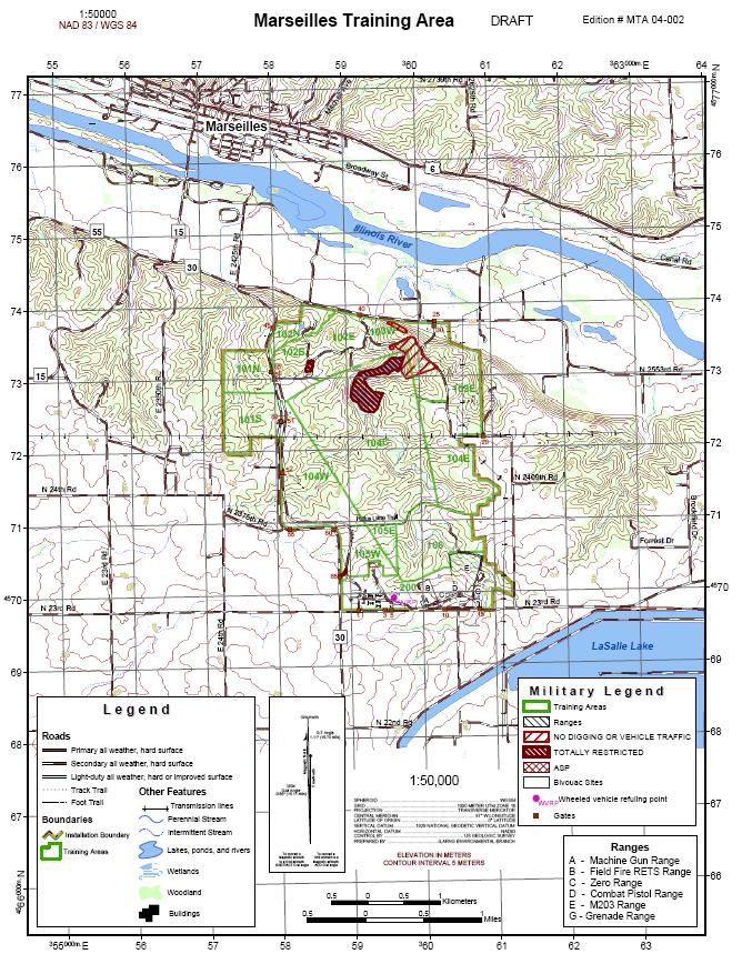
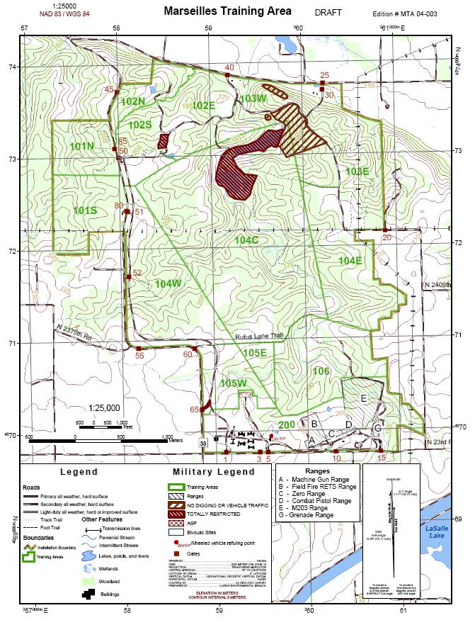
ILLINOIS ARMY NATIONAL GUARD Marseilles Training Area 1700 Army Road Marseilles, IL
|
|
|
- Todd Reed
- 5 years ago
- Views:
Transcription
1 ILLINOIS ARMY NATIONAL GUARD Marseilles Training Area 1700 Army Road Marseilles, IL Land Navigation Course Ph. (815) INDEX Chapter 1 GENERAL Page Guidance for OIC/Test Administrator 2-4 STUDENT INSTRUCTION SHEET (course requirements, course description, course point identification, pace counts, safety, injuries, pre-mature termination, test conduct, panic azimuth) Chapter 2 MTA MAP/OVERLAYS 5-7 Chapter 3 PRE-MADE TEST SHEETS 8-13 Chapter 4 ANSWER SHEETS Chapter 5 COMMON TASK LIST 20
2 ADVANCED LAND NAVIGATION COURSE 106 COURSE GUIDANCE FOR COURSE OIC/TEST ADMINISTRATOR I. Materials needed for Advanced Land Navigation Course: a. MTA 1:25000 scale map b. lensatic compass c. protractors d. pencils e. pre-made test sheets f. answer sheet matrixes II. Instructions for conducting the advanced land navigation course: There are several pre-made test sheets included in the course binder. This course is designed to run several relays of students through in a minimal amount of time. There are also answer sheet matrixes included for easy grading. To use them, simply determine which test sheet the student is using, locate the test answer sheet, and compare the answers to the students test sheet. It is also important that students have an opportunity to determine their pace counts prior to beginning the course prior to beginning the course. Finally, the students should be briefed on, or have the opportunity to read, the contents of the student instruction sheet provided. 2
3 ADVANCED LAND NAVIGATION COURSE 106 COURSE COURSE REQUIREMENTS: STUDENT INSTRUCTION SHEET TASK: Navigate over hilly and wooded terrain between points while dismounted. CONDITION: Given a 1:25000 scale topographic map of Marseilles Training Area, compass, protractor, pencil, and either: (1) an eight digit grid coordinate of the next point or (2) a distance and/or azimuth to the next point. STANDARD: Correctly determine the identification or eight-digit coordinate of all points to which you are directed. COURSE DESCRIPTION: This is a five-leg course over hilly and wooded terrain. COURSE POINT IDENTIFICATION: There are three sets of stakes. The six stakes in the first set are label SP1 through SP6 are the start points. The second sets of points are label MP1 through MP6. The third sets of points are label INT1 through INT 6. PACE COUNT: The pace count course will be marked with white stakes along the start points of this course. These stakes are 50 meters apart. Use these to measure your pace count. SAFETY: The panic azimuth is 90 degrees. Following this azimuth will lead you to a hard surfaced road. Once on the paved road, remain in place to be picked up by your unit or range control personnel. INJURIES: If you are injured and unable to follow the panic azimuth to the road, call for help. If you come upon someone who is injured, or respond to someone s call for assistance, render required first aid within your capabilities and knowledge. If you are the only person with the injured person, try calling for assistance. If a second person arrives, one of you should stay with the injured person while the other person follows the panic azimuth and gets help. If no one responds within a reasonable period of time, you must judge whether to wait with the person or to get help. If you leave REMEMBER THE INJURED PERSON S LOCATION so you can find it again. DO NOT IGNORE SOMEONE S CALL FOR ASSISTANCE the safety of your fellow soldiers is more important than completing the course. PREMATURE TERMINATION: If for any reason it is determined that conditions are no longer safe for the conduct of the land navigation course, a horn will sound three times in succession. IMMEDIATELY follow the panic azimuth to the road and wait for further instructions. 3
4 SAFETY CONT TEST CONDUCT: Determine you pace count. You should be able to perform to standard all skill level 1-4 navigation tasks listed in the Soldier s Manual of Common Tasks. You will be provided with an MTA 1:25000 scale map, a compass, protractor, pencil, and test sheet. The test sheet will direct you from one course point to the next by giving you either an eight digit grid coordinate, a distance and azimuth, or just an azimuth. You will be asked to record either the eight digit grid coordinate or the identification number of the point you have been directed to. Record this information in the appropriate space on the test sheet. If you reach the last point before time has expired, follow a 270 degree azimuth to the hard surface road and wait for further instructions or to be picked up. Turn in your test sheet to the test administrator. You will have minutes (hours) to complete the course. At the end of this time, a horn will sound three times. Immediately return to the road along the panic azimuth. Do you know the panic azimuth? Do you have any questions? 4
5 5
6 6
7 7
8 SCORESHEET FOR 106 LAND NAVIGATION COURSE YOU ARE AT UTM (SP1). 1. Go to UTM to find your first point. 2. Go to UTM to find your second point. 3. Go to UTM to find your third point. 4. Go to UTM to find your fourth point. 5. Go to UTM to find your last point. 8
9 SCORESHEET FOR 106 LAND NAVIGATION COURSE YOU ARE AT UTM (SP2). 6. Go to UTM to find your first point. 7. Go to UTM to find your second point. 8. Go to UTM to find your third point. 9. Go to UTM to find your fourth point. 10. Go to UTM to find your last point. 9
10 SCORESHEET FOR 106 LAND NAVIGATION COURSE YOU ARE AT UTM (SP3). 11. Go to UTM to find your first point. 12. Go to UTM to find your second point. 13. Go to UTM to find your third point. 14. Go to UTM to find your fourth point. 15. Go to UTM to find your last point. 10
11 SCORESHEET FOR 106 LAND NAVIGATION COURSE YOU ARE AT UTM (SP4). 1. Go to UTM to find your first point. 2. Go to UTM to find your second point. 3. Go to UTM to find your third point. 4. Go to UTM to find your fourth point. 5. Go to UTM to find your last point. 11
12 SCORESHEET FOR 106 LAND NAVIGATION COURSE YOU ARE AT UTM (SP5). 16. Go to UTM to find your first point. 17. Go to UTM to find your second point. 18. Go to UTM to find your third point. 19. Go to UTM to find your fourth point. 20. Go to UTM to find your last point. 12
13 SCORESHEET FOR 106 LAND NAVIGATION COURSE YOU ARE AT UTM (SP6). 1. Go to UTM to find your first point. 2. Go to UTM to find your second point. 3. Go to UTM to find your third point. 4. Go to UTM to find your fourth point. 5. Go to UTM to find your last point. 13
14 SCORESHEET FOR SOF LAND NAVIGATION COURSE YOU ARE AT UTM (SP1). 1. Go to UTM to find your first point. 727 meters 327 degrees (grid) 325 degrees (mag) Record marking on point here MP6 2. Go to UTM to find your second point. 861 meters 30 degrees (grid) 28 degrees (mag) Record marking on point here INT 1 3. Go to UTM to find your third point. 726 meters 299 degrees (grid) 297 degrees (mag) Record marking on point here INT 6 4. Go to UTM to find your fourth point meters 162 degrees (grid) 160 degrees (mag) Record marking on point here MP 4 5. Go to UTM to find your last point. meters degrees (grid) degrees (mag) Record marking on point here SP 6 14
15 SCORESHEET FOR SOF LAND NAVIGATION COURSE YOU ARE AT UTM (SP2). 6. Go to UTM to find your first point. meters degrees (grid) degrees (mag) Record marking on point here MP 3 7. Go to UTM to find your second point meters 335 degrees (grid) 333 degrees (mag) Record marking on point here INT 6 8. Go to UTM to find your third point. 575 meters 122 degrees (grid) 120 degrees (mag) Record marking on point here INT 2 9. Go to UTM to find your fourth point. 737 meters 169 degrees (grid) 167 degrees (mag) Record marking on point here Go to UTM to find your last point. 691 meters 182 degrees (grid) 180 degrees (mag) Record marking on point here SP 1 15
16 SCORESHEET FOR 106 LAND NAVIGATION COURSE YOU ARE AT UTM (SP3). 1. Go to UTM to find your first point. 818 meters 345 degrees (grid) 343 degrees (mag) Record marking on point here MP 5 2. Go to UTM to find your second point. 922 meters 358 degrees (grid) 356 degrees (mag) Record marking on point here INT 4 3. Go to UTM to find your third point. 506 meters 134 degrees (grid) 132 degrees (mag) Record marking on point here INT 1 4. Go to UTM to find your fourth point. 861 meters 210 degrees (grid) 208 degrees (mag) Record marking on point here MP 6 5. Go to UTM to find your last point. 727 meters 147 degrees (grid) 145 degrees (mag) Record marking on point here SP 1 16
17 SCORESHEET FOR 106 LAND NAVIGATION COURSE YOU ARE AT UTM (SP4). 6. Go to UTM to find your first point. meters degrees (grid) degrees (mag) Record marking on point here MP 3 7. Go to UTM to find your second point meters 341 degrees (grid) 339 degrees (mag) Record marking on point here INT 5 8. Go to UTM to find your third point. 947 meters 169 degrees (grid) 167 degrees (mag) Record marking on point here MP 5 9. Go to UTM to find your fourth point. 389 meters 136 degrees (grid) 134 degrees (mag) Record marking on point here MP Go to UTM to find your last point. meters degrees (grid) degrees (mag) Record marking on point here SP 2 17
18 SCORESHEET FOR 106 LAND NAVIGATION COURSE YOU ARE AT UTM (SP5). 1. Go to UTM to find your first point. 727 meters 18 degrees (grid) 16 degrees (mag) Record marking on point here MP 1 2. Go to UTM to find your second point. 862 meters 342 degrees (grid) 340 degrees (mag) Record marking on point here INT 3 3. Go to UTM to find your third point. 327 meters 310 degrees (grid) 308 degrees (mag) Record marking on point here INT 5 4. Go to UTM to find your fourth point. 947 meters 169 degrees (grid) 167 degrees (mag) Record marking on point here MP 5 5. Go to UTM to find your last point. 818 meters 165 degrees (grid) 163 degrees (mag) Record marking on point here SP 3 18
19 SCORESHEET FOR 106 LAND NAVIGATION COURSE YOU ARE AT UTM (SP6). 6. Go to UTM to find your first point. meters degrees (grid) degrees (mag) Record marking on point here MP 2 7. Go to UTM to find your second point. 906 meters 355 degrees (grid) 353 degrees (mag) Record marking on point here INT 2 8. Go to UTM to find your third point. 575 meters 302 degrees (grid) 300 degrees (mag) Record marking on point here INT 6 9. Go to UTM to find your fourth point meters 162 degrees (grid) 160 degrees (mag) Record marking on point here MP Go to UTM to find your last point. 618 Meters 157 degrees (grid) 155 degrees (mag) Record marking on point here SP 1 19
20 LAND NAVIGATION COURSE 106 COURSE COMMON TASKS REQUIRED # Identify topographic symbols on a military map 45 # Identify terrain features on a map..49 # Orient a map to the ground by map-terrain association.61 # Determine the grid coordinates of a point on a military map using the military grid reference system.65 # Determine a location on the ground by terrain association 76 # Determine a magnetic azimuth using a lensatic compass.78 # Determine direction using field-expedient methods..86 # Measure distance on a map 92 # Select a movement route using a map 19 # Navigate from one point on the ground to another point while dismounted.21 # Convert azimuths 29 # Orient a map using a lensatic compass..30 # Use a map overlay..32 # Determine the elevation of a point on the ground using a map..36 # Locate an unknown point on a map and on the ground by intersection.39 # Locate an unknown point on a map and on the ground by resection 42 # Determine azimuth using a protractor 45 # Compute back azimuths.50 20
ILLINOIS ARMY NATIONAL GUARD Sparta Training Area 715 Industrial Drive Sparta, IL 62286
 ILLINOIS ARMY NATIONAL GUARD Sparta Training Area 715 Industrial Drive Sparta, IL 62286 103 Land Navigation Course Ph. (309) 567-6810 INDEX Chapter 1 GENERAL Page Guidance for OIC/Test Administrator 2-4
USING THE MILITARY LENSATIC COMPASS
 USING THE MILITARY LENSATIC COMPASS WARNING This presentation is intended as a quick summary, and not a comprehensive resource. If you want to learn Land Navigation in detail, either buy a book; or get
USING THE MILITARY LENSATIC COMPASS
 USING THE MILITARY LENSATIC COMPASS WARNING This presentation is intended as a quick summary, and not a comprehensive resource. If you want to learn Land Navigation in detail, either buy a book; or get
USING THE MILITARY LENSATIC COMPASS
 USING THE MILITARY LENSATIC COMPASS WARNING This presentation is intended as a quick summary, and not a comprehensive resource. If you want to learn Land Navigation in detail, either buy a book; or get
USING THE MILITARY LENSATIC COMPASS
 USING THE MILITARY LENSATIC COMPASS WARNING This presentation is intended as a quick summary, and not a comprehensive resource. If you want to learn Land Navigation in detail, either buy a book; or get
ORIENTEERING LESSON 1: ORIENTEERING
 ORIENTEERING LESSON 1: ORIENTEERING PURPOSE This lesson will introduce you to orienteering, its techniques and terminology, as well as the various types of orienteering courses. In addition, many of the
MOUNTED LAND NAVIGATION
 CHAPTER 12 MOUNTED LAND NAVIGATION A vehicle commander should be able to navigate from one point on the ground to another with or without a compass. If separated from his unit and given an azimuth and
Advanced Land Navigation
 California Cadet Corps Curriculum on Map Reading Advanced Land Navigation LEADERS KNOW THE WAY 5/22/2017 Advanced Land Navigation Agenda C1. Advanced Map Reading Techniques C2. Land Navigation C3. Designing
USING THE MILITARY LENSATIC COMPASS
 USING THE MILITARY LENSATIC COMPASS WARNING This presentation is intended as a quick summary, and not a comprehensive resource. If you want to learn Land Navigation in detail, either buy a book; or get
OSSA MINIMUM SEARCH & RESCUE CERTIFICATION / QUALIFICATION CRITERIA BASIC LEVEL
 OSSA MINIMUM SEARCH & RESCUE CERTIFICATION / QUALIFICATION CRITERIA BASIC LEVEL Chapter 1 LEGAL ISSUES Through written evaluation the applicant will demonstrate knowledge of the legal issues involved in
Land Navigation at Nevada Youth Range Camp
 Curriculum 15-03 Land Navigation at Nevada Youth Range Camp Stephen S. Foster, Pershing County Extension Educator Sherm Swanson, Riparian and Rangeland Specialist This curriculum is used at Nevada Youth
USING THE MILITARY LENSATIC COMPASS
 USING THE MILITARY LENSATIC COMPASS WARNING This presentation is intended as a quick summary, and not a comprehensive resource. If you want to learn Land Navigation in detail, either buy a book; or get
LENSATIC COMPASS W140009XQ STUDENT HANDOUT
 B170249XQ UNITED STATES MARINE CORPS THE BASIC SCHOOL MARINE CORPS TRAINING COMMAND CAMP BARRETT, VIRGINIA 22134-5019 LENSATIC COMPASS W140009XQ STUDENT HANDOUT Warrant Officer Basic Course Introduction
MINIMUM SEARCH & RESCUE CERTIFICATION CRITERIA BASIC LEVEL
 MINIMUM SEARCH & RESCUE CERTIFICATION CRITERIA BASIC LEVEL Oregon State Sheriffs Association & Oregon Emergency Management 2005 First printed May 1975 Revised and reprinted August 1980 March 1984 March
FM CHAPTER 11 TERRAIN ASSOCIATION
 CHAPTER 11 TERRAIN ASSOCIATION Failure to make use of the vast amounts of information presented by the map and available to the eye on the ground reduces the chances for success in land navigation. The
Orienteering Michael Sorrentino EDU 255 Due: May 9th 2011
 Orienteering Michael Sorrentino EDU 255 Due: May 9 th 2011 Objectives Psychomotor 1. By the end of the unit, the students will be able to correctly pace themselves using the pacing technique 3 out of 4
LAND NAVIGATION: TOOLS AND TECHNIQUES
 TOOLS AND TECHNIQUES B1415 UNITED STATES MARINE CORPS Basic Officer Course The Basic School Marine Corps Combat Development Command Quantico, Virginia 22134-5019 B1415 LAND NAVIGATION: TOOLS AND TECHNIQUES
FIRST AID (Seven Life-Savings Steps)
") FIRST AID (Seven Life-Savings Steps) Ensure area is safe before approaching victim. 1. Check for responsiveness. a. Ask in a loud, but calm voice, "Are you okay?" b. Gently shake or tap the victim on the
FIRST AID (Seven Life-Savings Steps) Ensure area is safe before approaching victim. 1. Check for responsiveness. a. Ask in a loud, but calm voice, "Are you okay?" b. Gently shake or tap the victim on the
Navigation Using Compass
 Navigation Using Compass Updated January 2015 Albi Sole 0 Outdoor Council of Canada / Conseil canadien de plein air Published by The Outdoor Council of Canada / Conseil canadien de plein air KNA-101, 2500
ANSWER SHEET PART 4 EXPERT LAND NAVIGATION
 ANSWER SHEET PART 4 EXPERT LAND NAVIGATION 1. Knowing these four basic skills, it is impossible to be totally lost; what are they? a. Track Present Location / Determine Distance / Sense of Direction /
Appalachian Search and Rescue Conference (ASRC) Field Team Leader (FTL) Position Task Book (PTB)
 Field Team Leader (FTL) Position Task Book (PTB)") 5ARC Appalachian earch and Rescue Conference (ARC) Field Team Leader (FTL) Position Task Book (PTB) Position Task Book Assigned to: Position Task Book Initiated by: Individual s Name/Team Affiliation Name/Title/Date
5ARC Appalachian earch and Rescue Conference (ARC) Field Team Leader (FTL) Position Task Book (PTB) Position Task Book Assigned to: Position Task Book Initiated by: Individual s Name/Team Affiliation Name/Title/Date
Chapter 6 - The Compass Upon completion of this chapter, you will be able to:
 Chapter 6 - The Compass Upon completion of this chapter, you will be able to: Explain the use of the 360 degree system in defining direction. Identify the parts of a compass, i.e.: - base plate - magnetic
Choosing a North Reference
 Choosing a North Reference On your Map For your Compass For your GPS! When the north references are different, you will need to do conversions as you move bearings between your map, compass, and GPS. North
FM APPENDIX F ORIENTEERING
 APPENDIX F ORIENTEERING What is orienteering? Orienteering is a competitive form of land navigation. It is for all ages and degrees of fitness and skill. It provides the suspense and excitement of a treasure
Caerlee: Average Age = 6 (June 2017)
") Caerlee: Average Age = 6 (June 2017) Safety Able to follow M Check Take part in 10 minute blocks of cycling or coaching. Equity/ Social Able to interact and share with peers. Plays by the rules. Confident
Caerlee: Average Age = 6 (June 2017) Safety Able to follow M Check Take part in 10 minute blocks of cycling or coaching. Equity/ Social Able to interact and share with peers. Plays by the rules. Confident
TEST EXAM PART 3 ADVANCE LAND NAVIGATION
 NAME DATE TEST EXAM PART 3 ADVANCE LAND NAVIGATION 1. Knowing these four basic skills, it is impossible to be totally lost; what are they? a. Track Present Location / Determine Distance / Sense of Direction
USING THE MILITARY LENSATIC COMPASS
 USING THE MILITARY LENSATIC COMPASS WARNING This presentation is intended as a quick summary, and not a comprehensive resource. If you want to learn Land Navigation in detail, either buy a book; or get
PART 1 BASIC LAND NAVIGATION
 PART 1 BASIC LAND NAVIGATION USING THE MILITARY LENSATIC COMPASS WARNING This presentation is intended as a quick summary, and not a comprehensive resource. If you want to learn Land Navigation in detail,
Summary Report for Individual Task H-1508 Mark Center of Balance for a Multi-axle or Tracked Vehicle Status: Approved
 Report Date: 26 Jun 2014 Summary Report for Individual Task 551-88H-1508 Mark Center of Balance for a Multi-axle or Tracked Vehicle Status: Approved Distribution Restriction: Approved for public release;
Summary Report for Individual Task Compute Position Minimum Quadrant Elevation (Min QE) Status: Approved
 Status: Approved") Report Date: 05 Jun 2013 Summary Report for Individual Task 061-266-4009 Compute Position Minimum Quadrant Elevation (Min QE) Status: Approved DISTRIBUTION RESTRICTION: Approved for public release; distribution
Report Date: 05 Jun 2013 Summary Report for Individual Task 061-266-4009 Compute Position Minimum Quadrant Elevation (Min QE) Status: Approved DISTRIBUTION RESTRICTION: Approved for public release; distribution
RULES FOR MOUNTAIN BIKE ORIENTEERING
 RULES FOR MOUNTAIN BIKE ORIENTEERING Version 2012b April 2012 This second version of MTBO Rules for New Zealand has been developed by the NZOF MTBO Committee and updated twice after the 2012 Otago Carnival
Chartwork Learn the basics for position fixing using a number of techniques and a simple equation for speed, distance and time.
 Chartwork Learn the basics for position fixing using a number of techniques and a simple equation for speed, distance and time. Chartwork Chartwork Tools Accurate chart work is the basis for good navigation.
MOUNTAIN BIKE ORIENTEERING RULES
 MOUNTAIN BIKE ORIENTEERING RULES This third version of MTBO Rules for New Zealand has been developed by the Orienteering NZ MTBO Committee and revised after the Otago and Woodhill2Whaka Carnivals. These
Get Your Bearings.
 Get Your Bearings A compass tells you in what direction you are headed relative to magnetic north. You can combine use of a compass with pacing to find your way across country (where there may not be any
THE ARCHANGEL STANDARD OPERATING PROCEDURE: MILSIM SQUAD VERSION 1
 THE ARCHANGEL STANDARD OPERATING PROCEDURE: MILSIM SQUAD VERSION 1 Basic Military Elements I II III X XX Team or Crew Squad Platoon Company Battalion Regiment/Group Brigade Division Formations Fire Team
The activity is designed to take about an hour start to finish.
 Troop 606 Orienteering Course Overview This Orienteering Course is designed to help Scouts satisfy requirements 4a and 4b for the First Class Rank. These requirements are as follows (as of 2017): 4a. Using
ORIENTEERING APPENDIX F
 APPENDIX F ORIENTEERING What is orienteering? Orienteering is a competitive form of land navigation It is for all ages and degrees of fitness and skill. It provides the suspense and excitement of a treasure
Summary Report for Individual Task M-1650 Operate Vehicle Using Drivers Vision Enhancer Status: Approved
 Report Date: 05 Dec 2014 Summary Report for Individual Task 551-88M-1650 Operate Vehicle Using Drivers Vision Enhancer Status: Approved Distribution Restriction: Approved for public release; distribution
Standards ensure that SAR personnel are suitably trained and experienced and can therefore be relied on to operate efficiently and safely.
 AUCKLAND LANDSAR FIRST TEAM MINIMUM STANDARDS FOR AN ACTIVE MEMBER To be certain that searchers have the knowledge, skills and experience required to effectively participate in a search or rescue operation,
USING THE MILITARY LENSATIC COMPASS
 USING THE MILITARY LENSATIC COMPASS WARNING This presentation is intended as a quick summary, and not a comprehensive resource. If you want to learn Land Navigation in detail, either buy a book; or get
North, South, East & West Environmental Education Lesson Plan Edwards Camp and Conference Center
 North, South, East & West Environmental Education Lesson Plan Edwards Camp and Conference Center Updated 3/2011 SUMMARY In the North, South, East & West lesson the students will familiarize themselves
FM INDEX Index-1
 INDEX adjustment of fire, 6-13, 6-14, 6-24, 6-42, 6-46 AE (angle of elevation). See angle of elevation aiming-point method, 6-37 (illus), 6-41, 6-42 (illus) aiming-stake method, 6-38 ammunition, 1-9 (illus),
DOWNLOAD OR READ : MAP READING AND NAVIGATION PDF EBOOK EPUB MOBI
 DOWNLOAD OR READ : MAP READING AND NAVIGATION PDF EBOOK EPUB MOBI Page 1 Page 2 map reading and navigation map reading and navigation pdf map reading and navigation Map reading and land navigation at this
Characteristics. Advantages FM 31-19
 Special operations missions require rapid and clandestine infiltrations into operational areas or objectives across the operational continuum. Military free-fall (MFF) parachuting enables the commander
Shooting Sports Contest
 Competition Eligibility Rules 1. Every competitor must be currently enrolled in the 4-H shooting sports project. 2. Every competitor must possess a valid Colorado Hunter Education Safety card and must
Basic Chartwork. Necessary Tools. Navigation is the one science in which no margin whatever is left for the faker. - Felix Riesenberg
 Page 1 of 14 www.bananawind.us Navigation is the one science in which no margin whatever is left for the faker. - Felix Riesenberg Basic Chartwork You wouldn't want to attempt open ocean sailing using
Basic First Aid Manual 10th Edition
 We have made it easy for you to find a PDF Ebooks without any digging. And by having access to our ebooks online or by storing it on your computer, you have convenient answers with basic first aid manual
Auriol LCD sports watch with altimeter and compass
 Instruction manual Safety notes This electronic appliance must be protected from water* and other hazards. It is not a toy and children should not use it unsupervised. * Splash proof if worn on wrist.
What is the distance from Minneapolis to Duluth, computed via trunk highways? 155 miles (1 point) see chart at top of map
 see chart at top of map") Gopher Science Olympiad Invitational Road Scholar 2018 Answer Key; 60 points total MN State Highway map (15 points) What is the scale of this map? 1/16 inch = 1 mile (1 point for number, 1 point for units)
Gopher Science Olympiad Invitational Road Scholar 2018 Answer Key; 60 points total MN State Highway map (15 points) What is the scale of this map? 1/16 inch = 1 mile (1 point for number, 1 point for units)
AND INTERMEDIATE GENERAL INTERMEDIATE DIRECT SUPPORT 3-1 MAINTENANCE INSTRUCTIONS
 This copy is a reprint which includes current pages from changes 1 and 2. TECHNICAL MANUAL INTRODUCTION 1-1 UNIT, INTERMEDIATE DIRECT SUPPORT UNIT MAINTENANCE 2-1 INSTRUCTIONS AND INTERMEDIATE GENERAL
TECHNICAL MANUAL OPERATOR S MANUAL AREA PREDICTOR, RADIOLOGICAL FALLOUT, ABC-M5A2 (NSN )
") TECHNICAL MANUAL OPERATOR S MANUAL AREA PREDICTOR, RADIOLOGICAL FALLOUT, ABC-M5A2 (NSN 6665-00-106-9595) This reprint includes all changes in effect at the time of publication See inside front cover for
TECHNICAL MANUAL OPERATOR S MANUAL AREA PREDICTOR, RADIOLOGICAL FALLOUT, ABC-M5A2 (NSN 6665-00-106-9595) This reprint includes all changes in effect at the time of publication See inside front cover for
REGULATIONS. Orienteering
 REGULATIONS Governing Nordic Military Championship in Orienteering 2014 edition REGULATIONS FOR NORDIC MILITARY CHAMPIONSHIP IN ORIENTEERING TABLE OF CONTENTS 1. General Regulations 2. Administrative Regulations
Windcube FCR measurements
 Windcube FCR measurements Principles, performance and recommendations for use of the Flow Complexity Recognition (FCR) algorithm for the Windcube ground-based Lidar Summary: As with any remote sensor,
Summary Report for Individual Task Construct Cribbing System(s) to Stabilize a Load Status: Approved
 to Stabilize a Load Status: Approved") Report Date: 20 v 2014 Summary Report for Individual Task 052-247-1225 Construct Cribbing System(s) to Stabilize a Load Status: Approved Distribution Restriction: Approved for public release; distribution
Report Date: 20 v 2014 Summary Report for Individual Task 052-247-1225 Construct Cribbing System(s) to Stabilize a Load Status: Approved Distribution Restriction: Approved for public release; distribution
Surveying Fundamentals and Practices, 5/e
 Online Instructor s Manual to accompany Surveying Fundamentals and Practices, 5/e Jerry Nathanson Michael T. Lanzafama Philip Kissam Upper Saddle River, New Jersey Columbus, Ohio Copyright 2010 by Pearson
MAPPING DESCRIPTIONS AND DRAFTING PARCEL BOUNDARIES FOR CADASTRAL MAPPING
 MAPPING DESCRIPTIONS AND DRAFTING PARCEL BOUNDARIES FOR CADASTRAL MAPPING Chapter 6 2015 Cadastral Mapping Manual 6-0 Another method of describing land, aside from the fractional section method, is called
CK-12 Geometry: Special Right Triangles
 CK-12 Geometry: Special Right Triangles Learning Objectives Identify and use the ratios involved with isosceles right triangles. Identify and use the ratios involved with 30-60-90 triangles. Review Queue
Checklist For Planning And Conducting The LSA Materials (Class 7-Radioactive) Emergency Response Drill
 Emergency Response Drill") Drill Package Page: 1 of 7 Checklist For Planning And Conducting The LSA Materials (Class 7-Radioactive) Emergency Response Drill Drill Date (For additional information refer to the Guidance for Planning,
Drill Package Page: 1 of 7 Checklist For Planning And Conducting The LSA Materials (Class 7-Radioactive) Emergency Response Drill Drill Date (For additional information refer to the Guidance for Planning,
MUTCD Part 6: Temporary Traffic Control
 MUTCD Part 6: Temporary Traffic Control OMUTCD English units are preferred. OHIO MANUAL OF UNIFORM TRAFFIC CONTROL DEVICES TABLE OF CONTENTS PREFACE INTRODUCTION TABLE OF CONTENTS PART 1. GENERAL Chapter
ROPE BRIDGE. b. One rope bridge sites will be used for the Male Division,, Female and Mixed Divisions.
 APPENDIX 3 (ONE-ROPE BRIDGE) TO ANNEX C (OPERATIONS, V1) TO WARNORD #1 TO DELSEA ARMY JROTC OPERATIONS ORDER 18-01 (SOUTH JERSEY LEAGUE ARMY JROTC 2018 RAIDER COMPETITION) 1. General Scenario: ROPE BRIDGE
Centennial Fall Protection Work Plan _CP_11_20_en_A1
 Centennial Fall Protection Work Plan 0206500_CP_11_20_en_A1 Project Title: Contract and Task Order Number: Project Location (be specific, include Bldg. # / Floor / grid / etc.): PSO/SSHO Name: Complete
Dan Andrews. Expert Advisor to the Ontario Ministry of Tourism, Culture & Sport OPA Ed Conference, Burlington, ON March 1, 2018
 Dan Andrews Expert Advisor to the Ontario Ministry of Tourism, Culture & Sport OPA Ed Conference, Burlington, ON March 1, 2018 I Will Share With You Typical New User Experience Leading Towards Classification:
Prerequisites. Qualified GES The above listed member has completed the required prerequisite training for the urban direction finding team specialty.
 SECIALTY QUALIICATION TRAINING RECORD (SQTR) Urban Direction inding Team NAME (Last, irst, MI) CAID ISSUED rerequisites Item Date Completed Qualified GES The above listed member has completed the required
Perform a Rescue of an Injured or Entrapped Victim from a Collapsed Structure Status: Approved
 Report Date: 25 Apr 2017 052-247-1228 Perform a Rescue of an Injured or Entrapped Victim from a Collapsed Structure Status: Approved Distribution Restriction: Approved for public release; distribution
5th Grade Decimal Concepts
 Slide 1 / 192 Slide 2 / 192 5th Grade Decimal Concepts 2015-11-16 www.njctl.org Slide 3 / 192 Table of Contents What is a Decimal? Click on a topic to go to that section. Identify Place Values Read and
5th Grade. Slide 1 / 192. Slide 2 / 192. Slide 3 / 192. Decimal Concepts. Table of Contents
 Slide 1 / 192 Slide 2 / 192 5th Grade Decimal Concepts 2015-11-16 www.njctl.org Table of Contents Slide 3 / 192 What is a Decimal? Click on a topic to go to that section. Identify Place Values Read and
Sequoyah District Klondike Derby. January 27 29, Carter Park Knoxville, Tn.
 Sequoyah District Klondike Derby January 27 29, 2012 Carter Park Knoxville, Tn. Sponsored by the Sequoyah Chapter Order of the Arrow Pellissippi Lodge # 230 Boy Scouts of America Please note that we are
Declining Weight Blending System Quick Start Manual E Main St Marshall, IL Phone: Fax: Website:
 Declining Weight Blending System Quick Start Manual 12285 E Main St Marshall, IL 62441 Phone: 217-826-6352 Fax: 217-826-8551 Website: www.yargus.com P a g e 2 MAIN SCREEN The MAIN SCREEN on the cover page
Summary Report for Individual Task Install Survey Stakes for Horizontal Projects Status: Approved
 Report Date: 30 Oct 2013 Summary Report for Individual Task 052-243-1605 Install Survey Stakes for Horizontal Projects Status: Approved DISTRIBUTION RESTRICTION: Approved for public release; distribution
Pace and Compass. Teacher Instructions. Overview: Objectives: Materials:
 Teacher Instructions and Overview: Scientists use maps to record and monitor many geologic features, including lava flows, calderas, and volcano vents. The boundaries of these features can be mapped with
SOUTH ISLAND SCHOOLS ORIENTEERING FESTIVAL INCORPORATING. SATURDAY 20 May Maitai AND SUNDAY 21 May 2017 Nelson Central
 SOUTH ISLAND SCHOOLS ORIENTEERING FESTIVAL INCORPORATING South Island Secondary Schools Orienteering Championships South Island Year 7 & 8 Schools Orienteering Champs South Island Primary Schools Orienteering
Employ The Risk Management Process During Mission Planning
 Employ The Risk Management Process During Mission Planning TSG 154-6465 Task(s) TASK NUMBER TASK TITLE Taught or 154-385-6465 Employ The Risk Management Process During Mission Planning Supported Task(s)
FISH 415 LIMNOLOGY UI Moscow
 Sampling Equipment Lab FISH 415 LIMNOLOGY UI Moscow Purpose: - to familiarize you with limnological sampling equipment - to use some of the equipment to obtain profiles of temperature, dissolved oxygen,
Rocket Hazard Assessment for the Cirrus Airframe Parachute System (CAPS )
") Rocket Hazard Assessment for the Cirrus Airframe Parachute System (CAPS ) If you ve read the manual on the Cirrus website it s possible you may have asked yourself: how do I apply all this in the real
Rocket Hazard Assessment for the Cirrus Airframe Parachute System (CAPS ) If you ve read the manual on the Cirrus website it s possible you may have asked yourself: how do I apply all this in the real
Your First Event. All you need to know to take part
 Your First Event All you need to know to take part Orienteering is a sport combining navigation and exercise. You find a series of controls marked by an orange and white flag, using a map and, for more
Mastering the Mechanical E6B in 20 minutes!
 Mastering the Mechanical E6B in 20 minutes Basic Parts I am going to use a Jeppesen E6B for this write-up. Don't worry if you don't have a Jeppesen model. Modern E6Bs are essentially copies of the original
Lake Shelbyville Eco-Meet 2018
 Lake Shelbyville Eco-Meet 2018 42 nd Annual Ecology Meet Information Packet U.S. Army Corps of Engineers - St. Louis District Lake Shelbyville 1989 State Highway 16 Shelbyville, IL 62565 (217) 774-3951
New Stuyahok-Ekwok Intertie Route Wind Power Site Options
 New Stuyahok-Ekwok Intertie Route Wind Power Site Options November 30, 2015 Douglas Vaught, P.E. V3 Energy, LLC Anchorage, Alaska www.v3energy.com New Stuyahok-Ekwok Intertie Wind Power Site Options Page
Scout Skills Compass INFORMATION SHEET
 Scout Skills Compass 0845 300 1818 INFORMATION SHEET A compass is an instrument with a magnetised needle which points to (magnetic) north and is therefore used for determining direction. They come in different
USAIS PAMPHLET Expert Infantryman Badge
 USAIS PAMPHLET 350-6 Expert Infantryman Badge 11 MAY 2018 (Revised) All Previous Editions Obsolete DEPARTMENT OF THE ARMY United States Army Infantry School Page 1 Summary of Change USAIS Pamphlet 350-6
USING THE GPS TO WALK TRANSECTS. by Robert L. Hafey
 USING THE GPS TO WALK TRANSECTS by Robert L. Hafey This paper will provide specific instructions or suggestions on how to setup the GPS to facilitate transect walking for field surveys. Systematic field
OAI Operations Manual page 1 20-METER WALK TABLE OF CONTENTS
 OAI Operations Manual page 1 TABLE OF CONTENTS 20-METER WALK 1. Background and rationale...2 2. Equipment and supplies...2 2.1 Use of the stopwatch...2 3. Safety issues and exclusions...3 4. Course set-up...3
2016/04/03 Alaska Hoodoo Mountains, Eastern Alaska Range Published by Conrad Chapman Eastern Alaska Range Avalanche Center
 2016/04/03 Alaska Hoodoo Mountains, Eastern Alaska Range Published by Conrad Chapman Eastern Alaska Range Avalanche Center Avalanche Details Date: 03 April 2016 Time: 3:00 pm AST Location: Hoodoo Mountains,
Unit 8, Lesson 5: More Estimating Probabilities
 Unit 8, Lesson 5: More Estimating Probabilities Lesson Goals Explain why a probability estimate based on repeating an experiment many times may not be exactly equal to the actual probability for a given
CERN POLICIES AND PROCEDURES TRAINING DOCUMENT (Revised March 22, 2018)
") CERN POLICIES AND PROCEDURES TRAINING DOCUMENT (Revised March 22, 2018) Thank-you for volunteering as a CERN monitor! Your time is much appreciated even if you not hear an emergency call during your watch.
CERN POLICIES AND PROCEDURES TRAINING DOCUMENT (Revised March 22, 2018) Thank-you for volunteering as a CERN monitor! Your time is much appreciated even if you not hear an emergency call during your watch.
TERMS & CONDITIONS. AGE LIMIT All competitors must be at least 18 years old by the date of the event.
 TERMS & CONDITIONS AGE LIMIT All competitors must be at least 18 years old by the date of the event. REGISTRATION & REGISTRATION FEES Each competitor / relay team must complete an online registration form
Adventure Racing/Navigation 101
 Adventure Racing/Navigation 101 Adventure Racing (AR) is a multi-sport, team event in which racers navigate their way from checkpoint to checkpoint using a map, compass and route strategy within a set
Navigating Barker Inlet: some exercises
 Introduction The Torrens Island and nvirons map A few things have changed since the Torrens Island and nvirons (TI) map was published. The most obvious from Barker Inlet is the new silo and bulk grain
ADA PRESENTATION (CURB RAMPS)
") ADA PRESENTATION (CURB RAMPS) ACECNJ/NJDOT/FHWA DESIGN SUMMIT Warren Howard New Jersey Department of Transportation May 21, 2013 ADA Curb Ramps NJDOT wants curb ramps to be designed & constructed properly
ADA PRESENTATION (CURB RAMPS) ACECNJ/NJDOT/FHWA DESIGN SUMMIT Warren Howard New Jersey Department of Transportation May 21, 2013 ADA Curb Ramps NJDOT wants curb ramps to be designed & constructed properly
CONTROL and INSTRUMENTATION
 CONTROL and INSTRUMENTATION COURSE 500: 5 DAYS: Max 8 Candidates This course covers the key aspects of current instrumentation and process control technology and is designed to enable maintenance personnel
ASPHALT PAVING LEVEL 1
 ASPHALT PAVING LEVEL 1 Module 3: Yield Calculations: Tack Coat and Mix Spread Rate FDOT Course Module 3 1 Welcome the students to the third module in this course that covers tack coat and mix spread rates,
Pacific Charter Institute Pacing Guide Grade(s): _5 Subject Area: _Math in Focus grade 5 CP: yes _X no
: _5 Subject Area: _Math in Focus grade 5 CP: yes _X no") Week 1 Pre-requisite skills review Chapter 1 pre-test Assessment 5 chapter pre-test pp. 1-4 or MIF Student book 5A pp. 1-4 Reteach 4A (1.1, 1.2, 2.1, 3.2, 3.4) NWEA Kids start Wed. Week 2 1.1 Writing numbers
Week 1 Pre-requisite skills review Chapter 1 pre-test Assessment 5 chapter pre-test pp. 1-4 or MIF Student book 5A pp. 1-4 Reteach 4A (1.1, 1.2, 2.1, 3.2, 3.4) NWEA Kids start Wed. Week 2 1.1 Writing numbers
And Sponsored By: Nova Scotia Health Promotion
 Administered by: Nova Scotia Outdoor Leadership Development Program P.O. Box 864, Halifax, Nova Scotia B3J 2V2 And Sponsored By: Nova Scotia Health Promotion 2 Table of Contents Introduction 4 The Topographic
Lowland Leader Award. Lowland Leader Award
 Lowland Leader Award 1 Contents Introduction 4 Scope of the Lowland Leader Award Scheme 4 Stages in the Lowland Leader Award Scheme 5 Exemption from training or consolidation 8 Equal Opportunities 8 Complaints
Orienteering Canada. This revised document was approved by the Orienteering Canada Board in April 2017 W55+ W65+ W17-20B M17-20B M75+ W75+ W80+ M80+
 Orienteering Canada Course and category guidelines for Championship Events: North American Orienteering Championships Canadian Orienteering Championships Western Canadian Orienteering Championships Eastern
COMPASS / PACING GAME
 COMPASS / PACING GAME This is a fairly simple game to help scouts practice the basics of using a compass and pacing. Equipment needed: 200 square level area to play; 100 foot long tape or a rope with feet
Introduction to Roadway Design
 Chapter Introduction to Roadway Design 1 This chapter lays the foundation for the Roadway Design course. You examine the roadway design workflow and the completed drawing files and review the project scope,
Rescue Technician: Cave Rescue I/II
 Rescue Technician: Cave Rescue I/II Skill Sheet Package Based on NFPA 1006: Standard for Technical Rescue Professional Qualifications, 2013 Edition. Alabama Fire College August 2014 REVISED 02/10/2017
Field Manual Condensed (FMC) Machine Gun Tactics and Employment
 Machine Gun Tactics and Employment") Field Manual Condensed (FMC) 23-22 Machine Gun Tactics and Employment Falcon, United Operations http://www.unitedoperations.net/ FIELD MANUAL CONDENSED (FMC) 23-22 1 Page intentionally left blank. 2 FIELD
Field Manual Condensed (FMC) 23-22 Machine Gun Tactics and Employment Falcon, United Operations http://www.unitedoperations.net/ FIELD MANUAL CONDENSED (FMC) 23-22 1 Page intentionally left blank. 2 FIELD