Trans Canada Highway DRAFT Corridor Management Plan: Boys Road to Beverly Street
|
|
|
- Rachel Kelly
- 5 years ago
- Views:
Transcription
1 Trans Canada Highway DRAFT Corridor Management Plan: Boys Road to Beverly Street DRAFT Technical Memorandum Prepared for: District of North Cowichan City of Duncan Ministry of Transportation and Infrastructure Prepared by: Roseanne Parrott, P.Eng. April 10, 2014
2 Sign-off Sheet This document entitled Trans Canada Highway DRAFT Corridor Management Plan: Boys Road to Beverly Street was prepared by Stantec Consulting Ltd. (Stantec) for the account of City of Duncan and District of North Cowichan. The material in it reflects Stantec s best judgment in light of the information available to it at the time of preparation. Any use which a third party makes of this report, or any reliance on or decisions made based on it, are the responsibilities of such third parties. Stantec Consulting Ltd. accepts no responsibility for damages, if any, suffered by any third party as a result of decisions made or actions based on this report. Prepared by (signature) Roseanne Parrott, P.Eng. Reviewed by (signature) Graeme Masterton
3 Table of Contents EXECUTIVE SUMMARY... I 1.0 INTRODUCTION BACKGROUND EXISTING INFORMATION REVIEW EXISTING REVIEW FINDINGS CONSULTATION PROCESS SUMMARY OF RESULTS OPTION EVOLUTION Highway Intersections Active Transportation Local Roadway Network Access Management Local Trail Network Connectivity Traffic Calming Pedestrian and Cyclist TCH Crossings Summary Table PLANNING AND DEVELOPMENT PEDESTRIAN AND CYCLIST SAFETY Boys Road to Cowichan Way Cowichan Way to James Street / York Road James Street / York Road to Beverly Street TRANSIT ACCESS MANAGEMENT Median Treatment Business Access ROAD NETWORK Existing Conditions Proposed Works SPECIAL CONSIDERATIONS COORDINATION WITH UNIVERSITY LAP PROCESS RECOMMENDATION AND IMPLEMENTATION SHORT TERM PROJECTS Multi-Use Pathways, Bikeways, and Sidewalks (ST) Pedestrian and Cyclist TCH Crossings (ST) Accesses (ST) Median Treatments (ST) Gateway Improvements (ST) rp c:\users\rparrott\desktop\homework\duncan_tch\rpt_draft_tch_tech_memo_ docx i
4 5.1.6 Intersection Upgrades (ST) Local Roadway Network Connectivity (ST) Transit (ST) MEDIUM TERM PROJECTS Multi-Use Pathways, Bikeways, and Sidewalks (MT) Pedestrian and Cyclist TCH Crossings (MT) Accesses (MT) Median Treatments (MT) Gateway Improvements (MT) Intersection Improvements (MT) Local Roadway Network Connectivity (MT) Transit (MT) LONG TERM PROJECTS Multi-Use Pathways, Bikeways, and Sidewalks (LT) Pedestrian and Cyclist TCH Crossings (LT) Accesses (LT) Median Treatments (LT) Gateway Improvements (LT) Intersection Upgrades (LT) Local Roadway Network Connectivity (LT) Transit (LT) FUTURE OPTIONS Traffic Calming Pavement Marking Shortened One Way Couplet East-West E & N Rail Trail Roundabouts SUMMARY TABLE CONCLUSION LIST OF TABLES Table 1 Improvement Options Evaluation Summary Table 2 Recommended Projects Summary Short Term Projects Table 3 Recommended Projects Summary Medium Term Projects Table 4 Recommended Projects Summary Long Term Projects LIST OF FIGURES Figure 1 Existing TCH Corridor... 3 Figure 2 TCH Corridor Collision Data... 5 Figure 3 Overall Corridor Option Evolution Option Figure 4 Overall Corridor Option Evolution Option Figure 5 Overall Corridor Option Evolution Preferred Option Figure 6 Arterial Roadway Example Figure 7 Two Lane Roundabout Example Figure 8 Shared Space Roundel Example rp c:\users\rparrott\desktop\homework\duncan_tch\rpt_draft_tch_tech_memo_ docx ii
5 Figure 9 Pedestrian Fencing Example Figure 10 Urban Multi-Use Pathway Figure 11 Future TCH Access Configuration Example Figure 12 Cowichan River Trail Bridge and Gateway Concept Figure 13 Gateway Improvement Examples at the Cowichan River Bridges Figure 14 Gateway Improvement Examples Cowichan River Bridge Lighting Figure 15 Gateway Improvement Examples at Beverly Street Figure 16 Gateway Feature Structures Community Building Examples Figure 17 Radar Speed Signs Figure 18 Permanent Roadside Changeable Message Sign Example Figure 19 Traffic Calming Pavement Marking Examples Figure 20 Pedestrian Tunnel / Underpass Example Figure 21 Pedestrian Overpass Examples Figure 22 Pedestrian Count-down Indicator Figure 23 Public Education Initiatives Examples Figure 24 Interim Traffic Signing Examples for Cowichan River Bridges Figure 25 Pathway Safety Lighting Under Cowichan River Bridges Examples Figure 26 Pedestrian Crossing Innovations Figure 4.1A Existing Condition Boys Road to Cowichan Way Figure 4.1B Long Term Transportation Plan - Boys Road to Cowichan Way Figure 4.2A Existing Condition - Cowichan Way to Trunk Road...38 Figure 4.2B Long Term Transportation Plan Cowichan Way to Trunk Road...39 Figure 4.3A Existing Condition - Trunk Road to James Street/York Road...40 Figure 4.3B Long Term Transportation Plan - Trunk Road to James Street/York Road...41 Figure 4.4A Existing Condition - James Street/York Road to Beverly Street...43 Figure 4.4B Long Term Transportation Plan - James Street/York Road to Beverly Street...44 Figure 4.5 TCH Typical Sections...49 Figure 5.1 TCH Project Sequence - Boys Road to Cowichan Way..57 Figure 5.2 TCH Project Sequence - Cowichan Way to Trunk Road...58 Figure 5.3 TCH Project Sequence - Trunk Road to James Street / York Road..59 Figure 5.4 TCH Project Sequence - James Street / York Road to Beverly Street..60 rp c:\users\rparrott\desktop\homework\duncan_tch\rpt_draft_tch_tech_memo_ docx iii
6 Executive Summary The section of the Trans Canada Highway (TCH) that runs through the District of North Cowichan (DNC) and the City of Duncan (CoD) was originally constructed as a by-pass route around the City of Duncan due to traffic congestion. A similar situation has developed over the years along the by-pass as property has been sub-divided and developed. Properties abutting the highway have been allowed access directly off of the highway which has resulted in significant safety issues as well as exacerbating congestion as traffic volumes on the highway and intersecting roads increase. There have been many studies conducted in the last ten years relating to transportation and safety along this stretch of highway. The last Corridor Management Plan was conducted nearly ten years ago and an updated review of the corridor is due. This Corridor Management Plan (CMP) endeavors to provide an update in the form of a review of these previous reports and combine the findings with input from local corridor users to develop a CMP that is achievable and makes sense. Through extensive public consultation we have arrived at recommendations that we believe will be mutually acceptable to the public and the roadway authorities. We recommend a staged infrastructure improvement approach to address traffic congestion and access management incrementally. These recommendations are based on the corridor objectives that resulted from the consultations: i) Safety of pedestrians, cyclists, and motorists along the corridor. ii) iii) iv) Traffic congestion for local traffic and truck traffic travelling through the DNC and CoD between the cities of Nanaimo and Victoria. Accessibility for emergency services. Sustainability of local business and economy. v) Affordability of future infrastructure projects. A summary of the primary recommended infrastructure improvement projects are: Upgrade pedestrian indicators at signalized intersections to include count-downs. Extend sidewalk and add curb, gutter, and boulevard on west side of the TCH from James Street / York Road to Beverly Street. Construct a multi-use pathway along the east side of the TCH between Boys Road and Beverly Street complete with curb, gutter, and boulevard where feasible. rp c:\users\rparrott\desktop\homework\duncan_tch\rpt_draft_tch_tech_memo_ docx i
7 Construct attractive and functional gateways near Boys Road and Beverly Street to welcome people to the urban area and prevent unsafe pedestrian TCH crossings. Install permanent radar speed signs and changeable messaging signs to encourage motorists to reduce speeds before entering the urban area. Install temporary pedestrian activated signals at Cowichan Way and near University Way with future full signalized intersection at Cowichan Way and a pedestrian overpass near University Way. Improve local roadway network connectivity and parking opportunities to facilitate phasing out direct access off the TCH. Detailed traffic analysis to determine improvements to corridor intersections in terms of signal timing, number of turning lanes, and turning lane lengths. Construct a multi-use pedestrian bridge over the Cowichan River. James Street / York Road intersection realignment. The following report lays out in detail the process and results of this review, consultation, option development, planning, recommendations, and implementation strategy. While we recognize that the total list of recommendations is a long expensive one, the DNC, CoD, and MoTI will now need to work together to prepare a funding strategy, taking into consideration what is affordable, and further prioritize the most effective potential projects to plan for the analysis, design, purchasing, and saving required to make these projects a reality. rp c:\users\rparrott\desktop\homework\duncan_tch\rpt_draft_tch_tech_memo_ docx ii
8 1.0 Introduction With the continued economic and residential growth of both the City of Duncan and the District of North Cowichan, it is necessary to continue planning for the future infrastructure needs. The DNC and CoD hired Stantec Consulting (Stantec) to complete the University Village Local Area Plan (LAP) which will provide a land use plan that will take into account the growth potential of the DNC over the next 25+ years. As the LAP process progressed it became readily apparent that significant changes to the Trans Canada Highway are needed to address both safety concerns along the corridor as well as access / egress issues both in the short term and into the future. As such, the DNC, CoD, and MoTI hired Stantec to complete a review of the TCH corridor from Boys Road to Beverly Street, in conjunction with the current ongoing LAP process, and come up with an implementable Corridor Management Plan. The purpose of this CMP is to take existing information from previous studies; information, ideas, and concerns from local corridor users; and coordinate them with future land use plans to make infrastructure project and implementation recommendations for the corridor in the: i) Short term (approximately 1-5 years) - which would help alleviate immediate concerns. ii) iii) Medium term (approximately 5-10 years) - which would continue addressing various issues along the corridor while also preparing for future land use and long term corridor projects. Long term (approximately years) which would address future corridor needs while taking into consideration the LAP. rp c:\users\rparrott\desktop\homework\duncan_tch\rpt_draft_tch_tech_memo_ docx 1
9 2.0 Background 2.1 EXISTING INFORMATION REVIEW A number of studies, reviews, and plans have been prepared in the last ten years with regards to safety and transportation within and around the corridor area. Previous works of particular relevance to this CMP are: Trans Canada Highway Corridor Management Plan Drinkwater Road to Cowichan Bay Road prepared by Urban Systems October 2005 Safety Review of Trans Canada Highway Corridor: James Street to Beverly Street prepared by Bunt & Associates March 2009 DRAFT Duncan Area Active Transportation Plan and Design Guidelines prepared by Alta September 2013 Cowichan Valley Regional District Regional Parks & Trails Master Plan prepared by Lanarc Consultants Ltd. March 2007 Capital Regional District Regional Pedestrian & Cycling Master Plan prepared by Alta March 2011 Traffic Impact Assessment for Cowichan Place prepared by Boulevard Transportation Group October 2007 Cowichan Place Access Review prepared by Boulevard Transportation Group August 2007 DRAFT James-Alexander Neighborhood Traffic Calming Review prepared by Boulevard Transportation Group July 2006 City of Duncan Age-friendly Seniors Safety Project Report prepared by Pam Alcorn Project Facilitator July 2010 See over for an aerial diagram of the existing TCH corridor and local roadway network. rp c:\users\rparrott\desktop\homework\duncan_tch\rpt_draft_tch_tech_memo_ docx 2

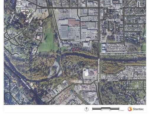
10 Figure 1 Existing TCH Corridor rp c:\users\rparrott\desktop\homework\duncan_tch\rpt_draft_tch_tech_memo_ docx 3
11 The following items were taken into consideration when reviewing these works: i) Safety issues. ii) iii) iv) Existing vehicular traffic patterns (including side streets and crossing movements) and expected future growth. Pedestrian and cyclist traffic patterns. Existing and potential future land use types and locations and their effect on traffic patterns and safety. v) Consideration for DNC and CoD plans for future infrastructure projects. vi) vii) Consideration for BC Ministry of Transportation and Infrastructure (MoTI) plans for the movement of people, goods, and services along the corridor. Consideration for BC Transit plans for future service improvements. 2.2 EXISTING REVIEW FINDINGS The Cowichan Valley has continued to grow through recent years; as such, existing residential and commuter traffic volumes are also on the rise. With the TCH bisecting both municipalities with limited roadway network connectivity, crossing and circulating movements for local traffic have experienced an increase in traffic congestion. An increase in traffic volumes inevitably carries with it an increase in the total number of collisions annually; however, this corridor experiences higher collision rates than is acceptable for the current traffic volumes on this type of roadway. These issues are partly due to the access density that has been allowed to grow as business developed along the highway, the posted speed reduction on the highway entering the urban area, and the mixing of traffic with different travel goals (i.e.: traveling through versus the local circulating traffic). The significant volume of truck traffic along the TCH between Nanaimo and Victoria has become an issue. This has contributed to a general feeling of unease by local pedestrian and cyclist corridor users as there are limited facilities geared towards active transportation and limited alternative routes. There are no bike lanes and the sidewalks are narrow and do not extend the length of the corridor. There have been a number of pedestrian casualties along this section of road, as the traffic in this area continues to grow and pedestrian traffic patterns remain the same (many mid-block crossings). As plans for the University Village expansion and the Cowichan Secondary School relocation progress, consideration for the safe movement of students will also play a key role in any future corridor improvements. See over for a diagram illustrating collision statistics from the Insurance Corporation of British Columbia (ICBC). rp c:\users\rparrott\desktop\homework\duncan_tch\rpt_draft_tch_tech_memo_ docx 4

 rp")
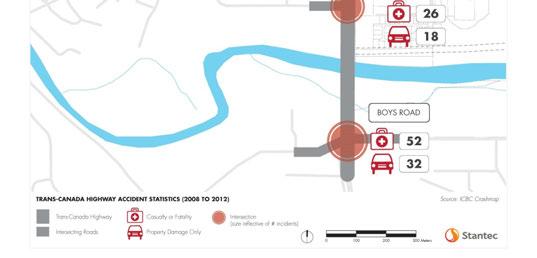
12 Figure 2 TCH Corridor Collision Data (Data source: ICBC.com) rp c:\users\rparrott\desktop\homework\duncan_tch\rpt_draft_tch_tech_memo_ docx 5
13 3.0 Consultation Proactive consultation with the local public, business owners, municipalities, transportation authorities, and Cowichan Tribes was done, as early as possible in the planning process, to ensure that ample opportunity was provided for affected corridor users to be involved, to be heard, carefully considered, and incorporated into the Corridor Management Plan. 3.1 PROCESS The following workshops and open houses were held to facilitate communication between the community and the planning team: i) Public information and comment via Place Speak website effective (January 2014 to March 25, 2014 for the CMP) ii) Cowichan Tribes / Environment Committee Meeting (November 29, 2013) iii) iv) Transportation authorities workshop (December 20, 2013) was held to take into consideration future plans and service improvements by the municipalities, MoTI, and BC Transit for the movement of people, goods, and services along the corridor. Stakeholder Advisory Group (SAG) Meeting #3 (December 5, 2013) - The SAG was created to represent the interests of the community as a whole and consisted of members of the Cowichan Tribes, the Cyclists Coalition, RCMP, Emergency Services, School Board, Vancouver Island University, TCH Owners, BC Transit, DNC and CoD, and MoTI (SAG Meetings #1 and #2 were for the LAP only). v) TCH Business Owner s Meeting #1 (December 5, 2013) vi) TCH Business Owner s Meeting #2 (January 5, 2014) vii) Stakeholder Advisory Group (SAG) Meeting #4 (February 5, 2014) viii) Youth / Schools (February 2014) ix) Public Open House #2 (February 26, 2014) (Public Open House #1 was for the LAP only) x) Stakeholder Advisory Group (SAG) Meeting #5 (April 1, 2014) xi) Public Open House #3 (April 14, 2014) rp c:\users\rparrott\desktop\homework\duncan_tch\rpt_draft_tch_tech_memo_ docx 6
14 3.2 SUMMARY OF RESULTS A summary of the primary concerns that were brought forward through these consultations form the general objectives for the TCH corridor CMP: i) Safety of pedestrians, cyclists, and motorists along the corridor. ii) iii) iv) Traffic congestion for local traffic and through traffic travelling through the DNC and CoD between the cities of Nanaimo and Victoria. Accessibility for emergency services. Sustainability of local business and economy. v) Affordability of future infrastructure projects. The Vision Statement for the TCH Corridor summarizes these objectives: The Trans Canada Highway and local road network improvements will support safe, welcoming, and convenient travel for all modes that is compatible with the surrounding land uses. It will provide a significant opportunity for creating an economic driver for the area through investment in hard and soft infrastructure that will facilitate residential intensification, infill and redevelopment, enhanced commercial and employment opportunities. 3.3 OPTION EVOLUTION Throughout the consultation process, various corridor improvement options and ideas were brought forward and revised. Following are some of the options as they evolved and why: Option 1 focused on active transportation and maintaining Trunk Road as the main entrance way to downtown Duncan. Option 2 focused on local roadway network connectivity, median treatments, and diverting traffic heading for downtown to Cowichan Way rather than Trunk Road to alleviate some intersection congestion at Trunk Road. The Preferred Option is a combination and optimized version of these two options that we believe will effectively and feasibly alleviate most of the corridor safety issues and reduce traffic congestion. Elements that were considered in the option evolution include: highway, intersections, active transportation, local roadway network, access management, local trail network connectivity, traffic calming, and pedestrian and cyclist TCH crossing. rp c:\users\rparrott\desktop\homework\duncan_tch\rpt_draft_tch_tech_memo_ docx 7

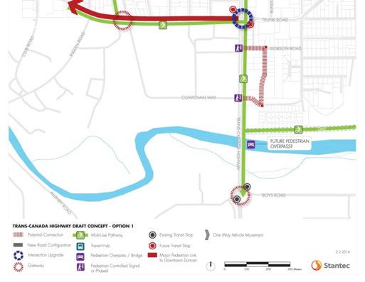
15 Figure 3 Overall Corridor Option Evolution Option 1 rp c:\users\rparrott\desktop\homework\duncan_tch\rpt_draft_tch_tech_memo_ docx 8


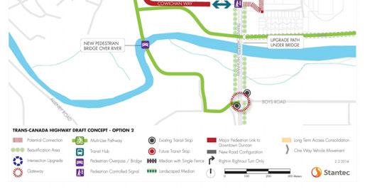
16 Figure 4 Overall Corridor Option Evolution Option 2 rp c:\users\rparrott\desktop\homework\duncan_tch\rpt_draft_tch_tech_memo_ docx 9
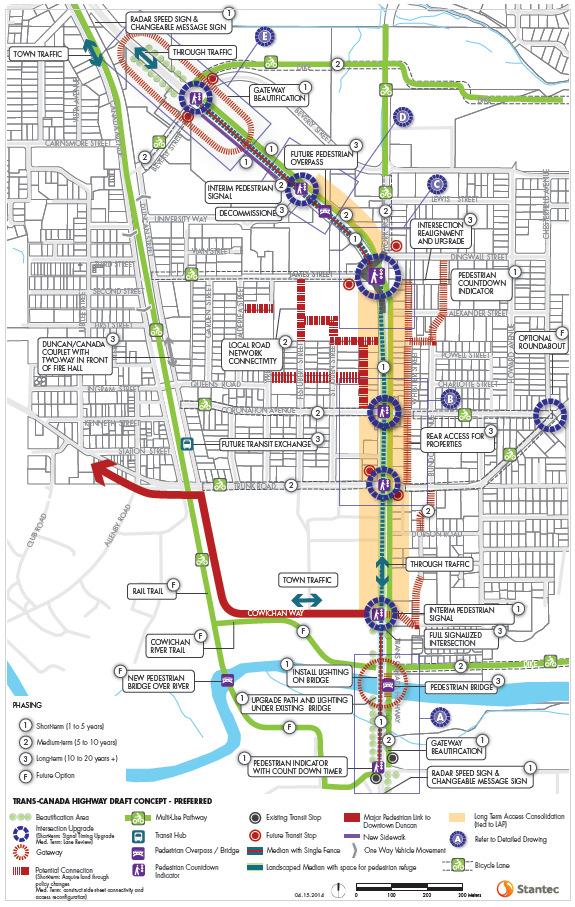
17 Figure 5 Overall Corridor Option Evolution Preferred Option rp c:\users\rparrott\desktop\homework\duncan_tch\rpt_draft_tch_tech_memo_ docx 10
18 3.3.1 Highway A few options were brought up regarding the Trans Canada Highway itself, most of which have been brought forward in the past in one form or another; some have been implemented, some have not. Options that were evaluated for the CMP were namely: widening the TCH, adding continuous right-turnonly lanes, creating a one-way highway couplet, and re-routing the TCH. TCH Widening Widening the TCH is not a feasible or desirable option because it would mean much wider paved area (aesthetically unattractive), a longer crossing width and time for circulating traffic and pedestrians (which would impact the performance of the intersections), and high cost due to right of way that would be required along the corridor, not to mention that additional turning lanes would likely achieve the desired effect without increasing the width of the corridor through its entire length. Continuous Right Turn Lanes Continuous right turn lanes (which motorists enter in order to turn at the next crossing road only, they are not to be used as through lanes) would mean the addition of a lane the length of the corridor which would add to the paved width and would require right of way acquisition. One-way Highway Couplet A one-way highway couplet may increase the intersection capacity and thus level of service, but would require significant infrastructure changes and would significantly affect properties along whichever direction were slated to be outside the existing corridor. There would still be intersections along the new stretch of corridor as well as existing accesses that would need to be addressed. TCH Alternate Route Re-routing the TCH would improve the traffic level of service by reducing the amount of conflicting movements (crossing travel paths) for local circulating traffic as well as highway through traffic, however the time savings would be negated for highway traffic by replacing a shorter corridor and signalized intersections with a longer corridor. This option is cost prohibitive, would likely affect some existing businesses along the existing TCH, and would significantly impact the environment and properties along any proposed new corridor. rp c:\users\rparrott\desktop\homework\duncan_tch\rpt_draft_tch_tech_memo_ docx 11

19 Figure 6 Arterial Roadway Example Intersections The intersections along the TCH were evaluated and similarly to the highway options, several ideas have been brought forward by previous studies, namely: the addition of lanes at intersections, grade separation at intersections, roundabouts, shared space roundels, and signal optimization / coordination. Additional Lanes Undoubtedly, adding turning lanes at the intersections would increase the capacity at the intersections, however the scope of this CMP does not cover detailed traffic analysis which would need to be done in order to make a more definitive plan with regards to how many lanes would be needed where, and how long they would need to be, in order to achieve the desired level of service. Adding lanes would make the intersections larger and would take pedestrians longer to cross and right of way would likely be required for the length of any additional lanes, depending on what other treatments are implemented (i.e.: widths of median, boulevard, shoulder, and sidewalk or path). Grade Separation Grade separation at the intersections would also certainly improve traffic flow and reduce the number of traffic conflicts, however in order to achieve the proper vertical clearance and maintain acceptable grades onto and off of the interchange ramps would mean hundreds of meters of inaccessible elevated roadway. This option is also cost prohibitive since it would require several new bridge structures and quite a bit of additional right of way. Incremental improvements should be implemented before resorting to such a drastic change. Grade separation remains a possibility far enough into the future. Roundabouts Roundabouts are quite common in other parts of the world and work quite well in certain conditions. There were circular junctions at intersections in North America at the turn of the last century. They since fell out of favor, but in the early 1990 s roadway authorities in North America began to re-introduce them as traffic calming devices to reduce congestion and the severity of collisions by channeling vehicles in the same direction (no head-on or high speed T-bone collisions). Roundabouts also reduce the pollution rp c:\users\rparrott\desktop\homework\duncan_tch\rpt_draft_tch_tech_memo_ docx 12

20 produced by idling vehicles, the noise made by the mass acceleration of a platoon of vehicles, and the roadway width required between intersections. Where left turn is prohibited, roundabouts provide the opportunity to turn around safely and efficiently. Unfortunately, we currently have a driver population that is somewhat unaccustomed to navigating multilane roundabouts, but as motorists are exposed to more of them, they become more comfortable with them. One lane roundabouts are much better received than two (or more) lane roundabouts due to the lack of public knowledge on how to navigate the two laned exit. Roundabouts function best when they can be located far enough away from signalized intersections that they are not overwhelmed by the platoons of vehicles and they do not have traffic back up into them. Roundabouts have very poor level of service for lower volume roads intersecting high volume roads where there is a very disproportionate traffic volume in one direction starving the intersecting road for gap opportunities to enter the roundabout. Another challenge is that pedestrians have farther to walk to cross the intersection if it is a roundabout and pedestrians with limited or no sight must rely on their hearing to determine where vehicles are. It can be quite challenging to distinguish circulating vehicles from exiting vehicles about to cross the pedestrian crossing using hearing alone. Roundabouts on highways generally require larger footprints due for the accommodation of large vehicles and to allow higher circulating speeds. This section of highway has a relatively low posted speed, however a roundabout at any of the corridor s intersections would still require additional right of way in order to accommodate the diameter needed for large trucks, two circulating lanes, and appropriate entrance and exit curve radii. Beverly Street and Boys Road are at or very near speed transition zones where motorists may not be expecting to encounter a roundabout which may pose a safety hazard. A detailed traffic analysis would need to be done in order to make a judgment on the feasibility of a roundabout here, but it remains a possibility in the future as Canadians gain experience driving them. It may be prudent to install a two lane roundabout within the local roadway network (such as at the intersection of Trunk Road and Coronation Avenue) and monitor motorist behavior over a few years. Figure 7 Two Lane Roundabout Example rp c:\users\rparrott\desktop\homework\duncan_tch\rpt_draft_tch_tech_memo_ docx 13

21 Shared Space Roundels Similar to a roundabout, a shared space roundel is a round intersection; however, they have no center island and no dedicated right of way given to any traffic movement at any given time. An example of this traffic innovation from Poynton in Great Britain where a congested intersection with heavy pedestrian and truck traffic was converted from a congested signalized intersection to a twin shared space roundel as illustrated in the figure below. The idea is that by not defining right of way, motorists are forced to negotiate (without words) the taking and giving of right of way. Pedestrian crossing is accommodated by refuge islands and differentiated pavement coloration for pedestrian crossing zones. Although we feel that this is very innovative, our professional opinion is that given the unfamiliarity of local motorists with roundabouts in general, it may be a better idea to test this type of solution at a lower risk intersection in the local roadway network. The TCH corridor would not make a good North American test candidate at this time. Figure 8 Shared Space Roundel Example Traffic Signal Optimization and Corridor Coordination Signal optimization is something that can temporarily improve the efficiency and level of service of an intersection as traffic volumes increase, if there is enough available capacity. Signal phasing can also be implemented to improve safety. Split phase timing for example, is when one direction at a time has a green light and all left turns and throughs are able to travel freely. Protected left turn phases on the other hand allow left turns in opposing directions to have a separate green time from through traffic. These should both be investigated as they create a much safer condition for vehicles turning left and for pedestrians, although they can increase the delay for other movements. Signal coordination through a corridor is when signals are optimized as a system to allow as much through traffic as possible to travel through a stretch of roadway without being delayed by more than a few red lights. Signal coordination rp c:\users\rparrott\desktop\homework\duncan_tch\rpt_draft_tch_tech_memo_ docx 14

22 also has its limitations. If signals are to be coordinated, they must be timed based on the lowest common denominator and can only be coordinated in one direction at any given time. There currently is signal coordination between signals along the corridor; however, it may be possible to improve this coordination with upgrades to allow coordination in one direction for the a.m. peak traffic and gradually switch the direction of coordination mid-day for the p.m. traffic. Of course, during the mid-day there would be limited coordination and signals would likely experience a period where they are neither optimized nor coordinated Active Transportation We looked at what could be done to improve active transportation along the corridor while ensuring safety and came up with a few options. Ideas brought forward include median / roadside fencing to discourage mid-block pedestrian crossing, replacing sidewalk with multi-use paths, a transit exchange along the highway, and a transit exchange / park and ride facility just off of the highway. Pedestrian Fencing Currently there are many pedestrians who choose to cross the TCH at uncontrolled locations which poses a serious safety risk. There are two predominant areas where these crossings occur: in the area between Boys Road and Cowichan Way, and between James Street / York Road and University Way. These are due to large pedestrian generating areas and pedestrian destination areas being separated by the TCH with inadequate crossing facilities. Students report having to wait long times during the lunch hour rush to cross the highway to reach the fast food restaurants on the other side. People crossing near the Cowichan River are traveling from their residences to a shopping hub and would have to go out of their way to cross at a designated crossing intersection. Median or road side fencing (in conjunction with appropriate crossing facilities) would serve to enforce the use of safe and designated crossing locations only. See figures in section TCH Traffic Calming for illustrations of median fencing that we recommend implementing. Figure 9 Pedestrian Fencing Example rp c:\users\rparrott\desktop\homework\duncan_tch\rpt_draft_tch_tech_memo_ docx 15

23 Multi-Use Pathways Many people also report feeling unsafe traveling along the corridor due to the heavy traffic and lack of separation from traffic by shoulder width, boulevard width, sidewalk width, and in some places a lack of sidewalk altogether. Many people also expressed that they would not feel comfortable cycling along the highway using a bike lane due to highway traffic volume and speed. Replacing regular width sidewalk with a 3 meter (minimum) to 4 meter (desirable) multi-use pathway would provide enough space to allow cyclists to safely use the corridor in both directions without endangering the safety of pedestrians. In order to accommodate a 4 meter pathway through the entire corridor, additional right of way would need to be acquired and some utilities may need to be relocated. Provision for a boulevard between a 3 meter multi-use path and the highway can be achieved without the requirement for additional right of way (in the absence of any additional turning lanes at the intersections) with a 4.3 meter shared outside lane which would not require a shoulder in place of having 3.7 meter outside lane which requires a minimum 1.5 meter shoulder. This 4.3 meter lane is intended to be shared between motorists and cyclists. Of course cyclists would have the option of using the shared lane or the multi-use pathway. A boulevard would also create a more effective buffer than a shoulder would due to the space not being occupied by vehicle traffic at any time, while providing an opportunity for beautification and rain gardens. We recommend installing a multi-use pathway in at least one direction along the TCH and provide for bicycle lanes as a minimum in the east west direction on the local roadways intersecting the TCH as the traffic speeds tend to be less on the local roadways. This does not mean that multi-use pathways could not be implemented east west in the future. We believe that the east side of the TCH is better suited for the multi-use pathway based on the existing commercial type and density. This may need to be re-evaluated in the future. Below is an illustration of an urban multi-use pathway in use. Figure 10 Urban Multi-Use Pathway rp c:\users\rparrott\desktop\homework\duncan_tch\rpt_draft_tch_tech_memo_ docx 16
24 Transit We saw opportunity for a transit exchange along the highway near Beverly Street where the existing roadway right of way is quite large. Normally this would not be prudent along a busy highway, however with the reduced speed limit and given the proper setback from through traffic on the highway, we believe this could be achieved safely. BC Transit has no plans for any additional bus stops directly off the highway at this time. There are currently plans to have a transit exchange near the railway tracks in downtown Duncan in future. We also considered the possibility of a park and ride facility to provide intercity commuters with an affordable and environmentally friendly alternative to driving themselves (often single occupancy vehicles). BC Transit currently has no plans for a park and ride facility in Duncan. Should commuter volumes increase, this may change Local Roadway Network With a lack of local roadway network connectivity, due in part by the lack of continuity between municipalities, local traffic is forced to use a limited number of roadways that do connect east to west and north to south (the TCH in particular). This lack of connectivity adds unnecessary congestion to the highway and is an inefficient use of the local roadway network. With sufficient local roadway network connectivity, local trips could be made with minimal use of the highway which would increase the level of service experienced at the highway intersections. The proposed local roadway extensions and connections would include adding backage roads parallel to the highway for safer access to local businesses along the highway. These connections would require additional right of way and would increase the local traffic on existing local roads Access Management The existing access density along much of the corridor is at an unacceptable level for a highway or urban arterial roadway. Accesses which are too near one another and/or intersections make it impossible to provide safe access once traffic volumes reach certain levels. Accesses in high vehicle and pedestrian traffic areas also create a safety issue for pedestrians as they cross the driveways. The challenge is to provide adequate access to existing businesses, while reducing the potential for collisions, and maintaining access for emergency services. Permanent left turn direct TCH (partial) access removal via raised median would be ideal in terms of safety (reduces the likelihood of side impact and head-on collisions) and corridor beautification, but may have an impact on existing business. Direct right turn access is safer than left turn access by the nature of collisions that may occur being mostly rear impact (same direction collisions are generally less severe). For pedestrians and cyclists however, it matters very little which type of turn is being performed in terms of severity, although left-turning vehicles may be less likely to be looking for pedestrians and more likely to be looking at oncoming traffic. Permanent right turn direct TCH (complete) access removal while rp c:\users\rparrott\desktop\homework\duncan_tch\rpt_draft_tch_tech_memo_ docx 17

25 providing indirect back or side road access is much safer than highway access since back roads have lower speeds and any vehicles turning left are crossing much less traffic. In order to provide adequate access to properties abutting the TCH where complete direct access is being removed, we propose that roadway right of way be acquired, as development permits or rezonings are sought, and that back road connections be constructed to the local roadway network for indirect access, as well as constructing shared parking areas on acquired parcels in strategic locations. As per the LAP, future redevelopment is encouraged to be located closer to the TCH with parking provided at the rear of the property with access provided through the local roadway network extended to improve accessibility for consumers and services. In the meantime, direct access will be reduced to eliminate second accesses and many left turn accesses, and pavement marking or colour-differentiated pavement is to be installed where sidewalks / pathways cross accesses. Where left turn access is granted to remain, it is to have channelizing raised median and will be re-evaluated in the future for safety. Figure 11 Future TCH Access Configuration Example Some concerns have been raised in the past regarding raised median and emergency access. It should be noted that motorists are required to make way for emergency vehicles displaying flashing lights and blaring sirens. Two lanes of highway in each direction provide ample width to complete this maneuver, as is the case in many other municipalities on Vancouver Island and in British Columbia. Where there is a requirement for emergency access from the opposing direction, median let-downs designed for emergency vehicles only can be installed. rp c:\users\rparrott\desktop\homework\duncan_tch\rpt_draft_tch_tech_memo_ docx 18
26 3.3.6 Local Trail Network Connectivity This option looked at other routes for cyclists and pedestrians to get to the downtown area and circulate around Duncan without using the TCH corridor. Several routes were identified: the E & N Rail Trail extension, Allenby Road, and using local roads east of the highway. The main challenge with any active transportation route is the infrastructure required to cross the Cowichan River safely. None of the existing bridges has adequate width for the safe travel of both pedestrians and cyclists. In order for any of these alternate routes to be viable, a separate pedestrian / cyclist bridge would need to be constructed. The following figures are renderings of our preferred concept: a pedestrian / cyclist bridge just east of the existing Cowichan River Bridges that would connect the recommended TCH multi-use pathway across the river. rp c:\users\rparrott\desktop\homework\duncan_tch\rpt_draft_tch_tech_memo_ docx 19

27 Figure 12 Cowichan River Trail Bridge and Gateway Concept Traffic Calming Traffic calming encompasses a wide variety of improvements that can be made to slow traffic to the posted speed and can range from geometric / physical roadway features to roadside features and paint marking. Basically anything that widens the driver s focus from the narrow space directly in front of the vehicle, to include the surrounding roadside. Some traffic calming ideas that have been brought forward during the review and consultation process are: gateways, posted speed reduction, radar speed signs, permanent changeable message signs, pavement markings, roundabouts, and roundels. Roundabouts rp c:\users\rparrott\desktop\homework\duncan_tch\rpt_draft_tch_tech_memo_ docx 20
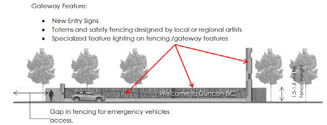
28 and roundels are discussed at length in section Intersections; below are descriptions of the other traffic calming ideas. Gateways Gateways are aesthetic features at the entrances to areas with the purpose of preparing drivers for the upcoming community and giving them a feel for the character of the community they are entering. In this area the gateways have a dual purpose of providing pedestrian median fencing. The entrance to Duncan from the south near Boys Road and the Cowichan River Bridges, for example, could have median features designed to represent a river flowing through totems or river reeds. rp c:\users\rparrott\desktop\homework\duncan_tch\rpt_draft_tch_tech_memo_ docx 21


29 Figure 13 Gateway Improvement Examples at the Cowichan River Bridges rp c:\users\rparrott\desktop\homework\duncan_tch\rpt_draft_tch_tech_memo_ docx 22


30 The Cowichan River Bridges are currently in a state of delayed painting maintenance due to environmental sensitivity surrounding the removal of the lead paint on the bridges. In the short term, to improve the visitors entering experience, bridge lighting could be added to create gateway enhancing effect similar to that illustrated below. Figure 14 Gateway Improvement Examples Cowichan River Bridge Lighting The entrance to the greater Duncan area from the north could have median features that represent the Somenos Marsh habitat north of Beverly Street with feature lighting to maintain the gateway s appeal during hours of darkness. Figure 15 Gateway Improvement Examples at Beverly Street Figure 16 Gateway Feature Structures Community Building Examples Posted Speed Reduction Posted speed reduction is another method of slowing traffic. It is not recommended for the entire corridor as it is a highway serving intercity traffic that is accustomed to travelling at much higher speeds. Since there is difficulty enforcing the current speed reduction from 80 km/h to 50 km/h, it is unlikely that any further reduction in posted speed would be effective. It may be possible to move the speed transition rp c:\users\rparrott\desktop\homework\duncan_tch\rpt_draft_tch_tech_memo_ docx 23


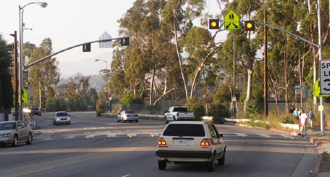
31 to 50km/h at the north end of the corridor further north to be in advance of Beverly Street gateway for southbound traffic. Radar Speed Signs Temporary radar speed signs have been used successfully in many areas to notify drivers whether the speed that they are traveling at is acceptable or not. In some areas, when the temporary radar speed signs are removed, the vehicle speed patterns return. Recently, permanent radar speed signs have been installed in some locations in Victoria with unknown success at this time. We believe that temporary or permanent radar speed signs would be effective at the posted speed reduction locations before entering the urban area. Figure 17 Radar Speed Signs Changeable Message Signs Temporary portable changeable message signs have been successfully used during highway and other infrastructure construction projects to inform motorists of changing conditions ahead. In the last number of years permanent changeable message signs have been introduced to provide opportunity for public safety education, warning for motorists of unforeseeable conditions ahead, weather advisories, construction ahead, etc. Permanent changeable message signs could be erected in advance of Boys Road northbound and Beverly Street southbound to notify drivers of the likelihood of encountering pedestrians in the urban area ahead and encourage them to exercise vigilance. The benefit of changeable message signs is that they can be changed on a regular basis to retain their freshness and can be used in cases of emergency to instruct drivers how to safely navigate or avoid hazards. Figure 18 Permanent Roadside Changeable Message Sign Example rp c:\users\rparrott\desktop\homework\duncan_tch\rpt_draft_tch_tech_memo_ docx 24


. Figure 19 Traffic Calming Pavement Marking Examples 3.")


32 Traffic Calming Pavement Marking Some roadway authorities in other jurisdictions in the UK and the United States have tried different pavement marking schemes to along the outer lane edges to give the appearance of narrower lanes in order to encourage motorists to slow down with varying degrees of success. Pavement markings provide a safe and cost effective alternative for influencing driver behavior without limiting large vehicle maneuverability and can easily be removed if proven ineffective. While not currently in the Canadian or British Columbian pavement marking standards; however, a test case could be applied for and perhaps tested in lower traffic volume locations. The following are some images of what has been tried elsewhere in terms of traffic calming pavement markings. We do, however, recommend the installation of pavement markings or color-differentiated pavement along the sidewalks / pathways that cross any driveways that will remain in order to alert the entering motorists that there may be pedestrians present (as shown in Figure 4.1). Figure 19 Traffic Calming Pavement Marking Examples Pedestrian and Cyclist TCH Crossings Pedestrian and cyclist safety while crossing the TCH is a major concern as these corridor users are the most vulnerable during collisions. Several options are available to enhance crossing safety: pedestrian tunnel(s)/underpass(es), pedestrian overpass(es), pedestrian activated traffic signals, pedestrian countdown indicators at intersections, pedestrian education campaign, corner curb bulb-outs at pedestrian crossings, and other pedestrian crossing lighting innovations. Pedestrian Tunnels / Underpasses Pedestrian tunnels have been installed on the island in the past with often little acceptance from users due to their size and lack of proper lighting. Pedestrian tunnels have been used in urban centers with great success when designed well. Unfortunately the flood risk in the area is not conducive to justifying the rp c:\users\rparrott\desktop\homework\duncan_tch\rpt_draft_tch_tech_memo_ docx 25


33 expenditure required to provide a welcoming underground structure. Below are some examples of appropriate scale and lighting for pedestrian comfort in tunnels. Figure 20 Pedestrian Tunnel / Underpass Example Pedestrian Overpasses Pedestrian overpasses are the next logical idea. If there is a high pedestrian crossing demand at a particular location, justification for the expense can be made. In order for the structure to be utilized by the public, it must be properly located and designed. For the TCH corridor, the conditions could be appropriate for a pedestrian overpass, between University Way and James Street / York Road, should plans for the Vancouver Island University expansion follow through. Any pedestrian structure should be constructed in conjunction with the recommended median fencing treatment described above. Below are some examples of attractive pedestrian overpasses. Figure 21 Pedestrian Overpass Examples Pedestrian Activated Traffic Signals In the interim, pedestrian activated traffic signals can be installed at locations where pedestrian overpasses are being contemplated. The reason for pedestrian activated traffic signals being undesirable as long term solutions is that they impede the flow of traffic and interfere with the corridor s traffic signal coordination. It may be possible to coordinate pedestrian activated traffic signals with the nearest upstream full traffic signal which would lead to longer wait times for pedestrians, but better traffic flow. Based on current pedestrian trip patterns, Cowichan Way and University Way are the logical locations for pedestrian activated signals in the short to medium term. Once the Cowichan Way pedestrian signal has been active for a few years in conjunction with median pedestrian fencing, pedestrian crossing patterns can be re-evaluated for the need for an additional crossing at Dobson Road. rp c:\users\rparrott\desktop\homework\duncan_tch\rpt_draft_tch_tech_memo_ docx 26


34 Pedestrian Count-down Indicators During consultation events, inadequate intersection crossing time has been mentioned. This may be due to an improper calculation of the required pedestrian crossing time, or pedestrians may be starting to cross in the middle of the pedestrian signal phase and having to rush to reach the other side before through traffic approaches. These situations are a safety concern and can affect the flow of traffic. This can be remedied by adjusting the traffic signal timing and upgrading the pedestrian indicators to include a count-down as illustrated in the image below. Pedestrian count-down indicators have been very popular wherever they are installed as the give the pedestrian the ability to make an informed decision as to whether or not they have enough time to complete the crossing safely. Figure 22 Pedestrian Count-down Indicator Public Education Initiatives Public education initiatives have been implemented in the past and are a cost effective way to educate the general public, especially students, of safe highway crossing behavior and the risks of choosing unsafe crossing locations. Students can be shown how to cross safely, safe crossing routes can be developed highlighting crossing locations and safe sidewalks and pathways to use. Below are some examples of pedestrian signing and pavement markings used to entertain and educate. We recommend that any pedestrian crossing infrastructure improvements be preceded by a public education campaign to encourage safe behavior and to explain improvements. Figure 23 Public Education Initiatives Examples rp c:\users\rparrott\desktop\homework\duncan_tch\rpt_draft_tch_tech_memo_ docx 27


35 In the interim period before any multi-use pathway bridge over the Cowichan River is constructed, signage should be erected at the sidewalk entrances instructing cyclists to dismount to cross the bridge. This should help inform them that cycling on the narrow bridge sidewalks poses a safety hazard to pedestrians. It may also be advantageous to install signs for motorists entering the bridge that any cyclists on the bridge be allowed full use of the outside lane. Figure 24 Interim Traffic Signing Examples for Cowichan River Bridges Corner Curb Bulb-outs Curb bulb-outs are commonly used at mid-block and corner pedestrian crossings to narrow the roadway at the crossing to slow traffic and make pedestrians desiring to cross more visible to the driver where there are parking lanes, bus lanes, or other auxiliary lanes that may block motorists view of waiting pedestrians. There is inadequate space between the pedestrian zone and the vehicle zone to provide effective corner curb bulb-outs along the TCH corridor as there are no parking or bus lanes and little shoulder width. In other words, any curb bulb-outs would be minimal at best; therefore, any functionality gained would not likely outweigh the cost to implement them. There is also real danger of large turning vehicles over-tracking onto a curb bulb-out where pedestrians expect to be able to wait in safety. Any bollards put in place to mitigate this safety hazard would likely impede truck turning movements. rp c:\users\rparrott\desktop\homework\duncan_tch\rpt_draft_tch_tech_memo_ docx 28


36 Pedestrian Crossing Lighting Under the north ends of the Cowichan River Bridges there is an unofficial path that crosses the TCH under the bridges. People report feeling unsafe using that path, however there is an opportunity to improve the existing path as an alternative TCH crossing location. There is also a pathway along the dike on the north bank of the Cowichan River. We propose installing lighting under the bridges in the interim to improve safety with the intention of making the path official and extending it along the north bank towards the E & N railway to connect to the future E & N trail extension. This will also serve to enhance the local trail network connectivity. It should be noted, however, that upgrading this pathway would involve geotechnical and environmental challenges and the pathway would be closed and allowed to flood every year during high runoff periods. Figure 25 Pathway Safety Lighting Under Cowichan River Bridges Examples Pedestrian Crossing Lighting Innovations There are also pedestrian crossing safety innovations being implemented in other jurisdictions that may not be suitable for this corridor, but are worth illustrating for future reference. Below are illustrations of pedestrian crossing holograms and in-pavement lighting. Holograms, similar to the one illustrated below, may be a bit extreme for this corridor and could cause rear-end collisions for drivers unaccustomed to them. It would be of use in situations where driver attention is drawn in many directions in a busy urban environment. In-pavement lighting may be more common in the future, but may also pose maintenance issues. We recommend a wait and see approach for the time being. rp c:\users\rparrott\desktop\homework\duncan_tch\rpt_draft_tch_tech_memo_ docx 29

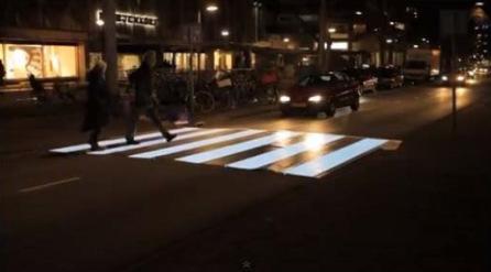
37 Figure 26 Pedestrian Crossing Innovations rp c:\users\rparrott\desktop\homework\duncan_tch\rpt_draft_tch_tech_memo_ docx 30
38 3.3.9 Summary Table While no solution is perfect, we endeavor to provide the most reasonable solutions. Below is a table that summarizes the options described above and their respective suitability. Legend for the table below: On a scale from 1 to 5, 1 being unsuitable and 5 being most suitable Not Applicable For example: for a safety column yellow would indicate that the option is neither safe, nor unsafe or has elements of safety and risk that more or less cancel each other out; for the cost column a red would indicate the option is cost prohibitive; under the traffic flow column a dark green would indicate an improvement in traffic flow, increase in capacity or reduction in volume by providing alternate routes and an orange would indicate that flow is decreased. Table 1 Improvement Options Evaluation Summary Improvement / Evaluation Criteria Safety (Ped.) Safety (Veh.) Traffic Flow Emergency Access Economic Sustainability Cost Environment Impact TCH Widening Continuous RT Only Lanes One Way Highway Couplet Alternate TCH Route Add Intersection Turn Lanes Intersections Grade Separation East / West One Way Couplet Roundabouts Shared Space Roundels Signal Optimiz. / Coord. Pedestrian Fencing Multi-Use Paths Transit Exchange Transit Exchange/Park N Ride Local Road Network Connect. Direct TCH Access Removal Trail Network Connections Gateways Posted Speed Reduction Radar Speed Signs Permanent Changeable Message Signs rp c:\users\rparrott\desktop\homework\duncan_tch\rpt_draft_tch_tech_memo_ docx 31
39 Improvement / Evaluation Criteria Safety (Ped.) Safety (Veh.) Traffic Flow Emergency Access Economic Sustainability Cost Environment Impact Traffic Calming Pavement Markings Pavement Markings Across Driveways Pedestrian Tunnel(s) Pedestrian Overpass(es) Pedestrian Signals Pedestrian Count-Down Indicators Pedestrian Education Initiatives Under Bridge Lighting for Path Corner Curb Bulb-Outs Pedestrian Crossing Innovations rp c:\users\rparrott\desktop\homework\duncan_tch\rpt_draft_tch_tech_memo_ docx 32
40 4.0 Planning and Development To enable the continued coordination between the DNC, CoD, MoTI, Cowichan Tribes, local corridor users / business owners, and the planning team, a linear development plan was implemented to systematically collect all required information, meet with affected users, and develop options that will address the short, medium, and long term objectives for the corridor. Listed below are the various improvements that were identified for the final recommendations. 4.1 PEDESTRIAN AND CYCLIST SAFETY As the volume of pedestrian, bicycle, and vehicular traffic along the corridor increases, there are inevitably more conflicts between these different modes of transportation. Increasing the number of travel conflicts have led to growing concern about pedestrian and cyclist safety (both crossing the highway and driveways accessing businesses along the TCH). With a significant proportion of the pedestrian trips crossing the TCH and a number of unsafe mid-block crossing fatalities, a clear and concise pedestrian transportation plan needed to be developed. This plan was broken into 3 significant locations: Boys Road to Cowichan Way, Cowichan Way to James Street / York Road, and James Street / York Road to Beverly Street Boys Road to Cowichan Way There is a considerable amount of pedestrian traffic traveling along the TCH from the residential areas along the east side of the TCH, especially in the area near Boys Road northward over the existing bridges to the commercial developments on the west side just north of Cowichan Way. The existing TCH currently has minimum width sidewalks on both sides of the highway adjacent to the traveled lanes separated from vehicular traffic by curb and gutter only. There are no bike lanes for cyclists who then use the sidewalks because they feel safer doing so. It is illegal for cyclists to travel on regular sidewalk; cyclists travelling on the sidewalk also create a safety hazard for pedestrians since the existing sidewalks are too narrow to accommodate mixed use. Pedestrians have also reported feeling unsafe walking along the sidewalks of this section of the corridor due to heavy truck traffic primarily using the outside lanes directly adjacent to the sidewalks where there are no existing shoulders, bike lanes, or boulevard to provide any separation or buffer. In addition to this, there are no dedicated pedestrian crossings through this section of the corridor and many pedestrians choose to cross the TCH unsafely at mid-block. There is little to no refuge along the narrow median and as such these pedestrians end up caught on the existing median or in the dedicated left turn lanes while waiting for a gap in one direction while impeding traffic in the other direction. One way to reduce the vulnerability of pedestrians and cyclists through this section of the corridor (and the entire TCH corridor from Boys Road to Beverly Street) would be to provide a wide multi-use path (3 meters minimum) for the shared use of pedestrians and cyclists with a landscaped boulevard along the east side of the TCH. This provides for cyclists who feel uncomfortable riding on the highway, yet maintains the safety of pedestrians by allowing enough room for both types of users. With a wide pathway along the east side of the TCH, the existing narrow sidewalk along the west side could be rp c:\users\rparrott\desktop\homework\duncan_tch\rpt_draft_tch_tech_memo_ docx 33
41 COWICHAN WAY TRANS-CANADA HIGHWAY 1 TRANS-CANADA HIGHWAY 1 McKINSTRY RD RIVERSTONE (RESIDENTIAL) AL WILSON GROVE SUN VALLEY MALL CASINO MIXED RETAIL WHITE SPOT TRAVELODGE CONFERENCE CNTR RESTAURANT SUN FM SERIOUS COFFEE TARP & TOOL VACANT RESIDENTIAL PRIVATE RD BOYS RD Proposed Highway Proposed Sidewalk Proposed Landscaping Future Connections Proposed Crosswalk FIGURE 4.1A TRANS CANADA HIGHWAY Directional Arrow EXISTING CONDITION Lane Lines BOYS ROAD TO COWICHAN WAY Median Fencing
42 MIXED RETAIL COWICHAN WAY WHITE SPOT CASINO TRANS-CANADA HIGHWAY 1 TRAVELODGE CONFERENCE CNTR RESTAURANT SUN FM McKINSTRY RD PROPOSED FUTURE SIGNALIZED INTERSECTION RIVERSTONE (RESIDENTIAL) AL WILSON GROVE SHARED PEDESTRIAN / BIKE PATH FROM BOYS RD. TO BEVERLY ST. PROPOSED PEDESTRIAN / BIKE STRUCTURE IMPROVED LIGHTING AND PATHWAY UNDER STRUCTURE SUN VALLEY MALL TRANS-CANADA HIGHWAY 1 TARP & TOOL FEATURE LIGHTING FOR BRIDGE SAFETY MEDIAN FENCE FROM BOYS RD. TO COWICHAN WAY BY LOCAL ARTIST PEDESTRIAN MEDIAN FENCING SERIOUS COFFEE VACANT RESIDENTIAL PRIVATE RD BOYS RD Proposed Highway Proposed Sidewalk Proposed Landscaping Future Connections Proposed Crosswalk FIGURE 4.1B TRANS CANADA HIGHWAY Directional Arrow TRANSPORTATION PLANNING Lane Lines BOYS ROAD TO COWICHAN WAY Median Fencing
43 maintained as it is to provide localized access to businesses and the local roadway network with the main north / south movement of pedestrians and cyclists focused along the east side of the TCH. Another way to increase the separation between pedestrians and vehicle traffic is to widen the outside lanes from 3.7 meters to a 4.3 meter shared vehicle / bicycle lane which eliminates the need for a shoulder and provides space for cyclists who choose to ride on the roadway. Should a wide multi- use pathway be constructed on the east side of the TCH from Boys Road to Beverly Street, there would still be limited sidewalk width on the existing bridge structure. A separate bridge structure for the shared use of pedestrians and cyclists (4 meters minimum to allow for shy distance or buffer between the parapets and the traveled way) could be constructed parallel to the existing structures to provide continuity and a safer Cowichan River crossing for pedestrian and cyclist traffic. There is an existing path that runs east / west along the north bank dike of the Cowichan River with an unofficial path under the existing Cowichan River bridges. Despite this crossing eliminating any potential conflict with vehicles on the highway, many people indicate feeling unsafe there and avoid it because it is dark. Lighting along the underside of the bridges would provide an element of safety for pedestrians and cyclists traffic travelling east / west. More pedestrians and cyclists choosing this TCH crossing, would alleviate some of the crossing demand in the area. There is also potential for this path crossing under the TCH to be made into an official pathway that connects the dike path to the future E & N trail to the west giving pedestrians and cyclists another route for getting to downtown Duncan. Should lighting be installed under the Cowichan River bridges, there will be pedestrians and cyclists who may not be able to use this crossing and would rather cross at roadway level. A dedicated pedestrian crossing in the area between the Cowichan River and Cowichan Way is needed since this is where a large number of mid-block crossings occur. The uncontrolled intersection at Cowichan Way is the logical location for such a crossing. Cowichan Way could be upgraded to have a pedestrian controlled signal in the interim with the provision for it to become a fully signalized intersection as connecting roads, such as the Price Road connection, become implemented. Another problem that exists with mid-block crossings of the TCH is that no matter how many safe dedicated crossings there are, some pedestrians will still choose to cross unsafely with the intention of shortening their trip. Introducing decorative fencing along the median throughout the entire length of this section of highway would impede unsafe mid-block crossing while providing the opportunity to create a visually appealing gateway into the CoD and DNC. That way pedestrian and bicycle crossings will be handled in a safe and efficient manner Cowichan Way to James Street / York Road Consistent with the situation mentioned above, the existing pedestrian facilities along the section of the TCH from Cowichan Way to Trunk Road are also deemed to be too close to the existing traffic lanes and there are no bicycle facilities. From Trunk Road up to James Street / York Road there is an existing boulevard separating the existing sidewalk from the traveled lanes. rp c:\users\rparrott\desktop\homework\duncan_tch\rpt_draft_tch_tech_memo_ docx 36
44 Upgrading the sidewalk along the east side of the TCH between Cowichan Way and James Street / York Road to a 3 meter wide (minimum) multi- use pathway with a 1 meter wide (minimum) boulevard and 4.3 meter outside lanes (northbound and southbound) would have the same benefits as mentioned in the previous sub-section. Similarly, the existing 1.5m sidewalk, and 1m boulevard, running along the west side of the TCH could remain as it is with minor modifications as required for commercial access and southbound dedicated right turn lanes. rp c:\users\rparrott\desktop\homework\duncan_tch\rpt_draft_tch_tech_memo_ docx 37
45 PRICE RD ST. JULIEN ST BUNDOCK AVE McKINSTRY RD TRUNK RD COOP GAS RESTAURANT TRANS-CANADA HIGHWAY 1 TRUNK RD DOBSON RD McKINSTRY PL COWICHAN WAY CASINO SAFEWAY ROMEO'S FITNESS HEARING SHOPPER'S DRUG MART PIZZA HUT SCOTIABANK PETROCAN 7-ELEVEN TD CHEVRON THRIFT DRYCLEAN LOANS VACUUM RSTRNT TRANS-CANADA HIGHWAY 1 LOANS DUNCAN DQ SUBWAY PETS LOCKSMITH McKINSTRY RD SHELL FOOD LOCKSMITH FRAMING TROPHIES MIXED RETAIL WHITE SPOT TRAVELODGE CONFERENCE CNTR RESTAURANT SUN FM RIVERSTONE (RESIDENTIAL) AL WILSON GROVE Proposed Highway Proposed Sidewalk Proposed Landscaping Future Connections Proposed Crosswalk FIGURE 4.2A TRANS CANADA HIGHWAY Directional Arrow EXISTING CONDITION Lane Lines COWICHAN WAY TO TRUNK ROAD Median Fencing
46 PRICE RD ST. JULIEN ST PIZZA HUT FITNESS HEARING SHOPPER'S DRUG MART SCOTIABANK PETROCAN 7-ELEVEN TD SHARED PEDESTRIAN / BIKE PATH FROM BOYS RD. TO BEVERLY ST. BUNDOCK AVE McKINSTRY RD TRUNK RD PROPOSED NORTHBOUND AND SOUTHBOUND DEDICATED RIGHT TURN LANES ONTO TRUNK RD. TRANS-CANADA HIGHWAY 1 TRUNK RD DOBSON RD McKINSTRY PL COWICHAN WAY TRANS-CANADA HIGHWAY 1 McKINSTRY RD CASINO SAFEWAY ROMEO'S LOANS DUNCAN DQ SUBWAY PETS LOCKSMITH CHEVRON SHELL COOP GAS RESTAURANT THRIFT DRYCLEAN LOANS VACUUM RSTRNT FOOD LOCKSMITH FRAMING TROPHIES MIXED RETAIL WHITE SPOT TRAVELODGE CONFERENCE CNTR RESTAURANT SUN FM PROPOSED FUTURE SIGNALIZED INTERSECTION RIVERSTONE (RESIDENTIAL) AL WILSON GROVE Proposed Highway Proposed Sidewalk Proposed Landscaping Future Connections Proposed Crosswalk FIGURE 4.2B TRANS CANADA HIGHWAY Directional Arrow TRANSPORTATION PLANNING Lane Lines COWICHAN WAY TO TRUNK ROAD Median Fencing
47 YORK RD THRIFT KARATE DINGWALL ST JAMES ST ALEXANDER ST ROYAL LEPAGE INSURANCE POWELL ST FESTUBERT ST PHOTO / SALON / VET CHIROPRACTOR RESTAURANT TANNING WINE MAKING COPY / THRIFT COWICHAN SECONDARY COMICS PRINTING COMPUTER CAFE DELI PEGASUS RESTAURANT ASIAN CUISINE ISLAND SAVINGS CENTRE COMMUNITY POOL WENDY'S PIZZA PASTA WINGS A&W THUNDERBIRD MOTOR INN CITIZEN LAWYER FOUNDATION BICYCLE DOMINO'S MUSIC REMAX BOW MEL CHRYSLER DODGE JEEP RAM DEALERSHIP KEN EVANS FORD DEALERSHIP TRANS-CANADA HIGHWAY 1 LOGHOUSE: FOOD PRIMERICA LOANS BUTCHER PAWN BOUTIQUE TRAN HAIR ELECTRIC OUTLET APPLE PRESS M&M AUTOBODY WHISTLER ST BUNDOCK AVE CHARLOTTE ST CORONATION AVE FESTUBERT ST ST. JULIEN ST Proposed Highway Proposed Sidewalk Proposed Landscaping Future Connections PIZZA HUT FITNESS HEARING SHOPPER'S DRUG MART SHELL LOANS DUNCAN PETS SUBWAY LOCKSMITH Proposed Crosswalk FIGURE 4.3A TRANS CANADA HIGHWAY Directional Arrow EXISTING CONDITION Lane Lines TRUNK ROAD TO JAMES STREET / YORK ROAD Median Fencing
48 ISLAND SAVINGS CENTRE COMMUNITY POOL ASIAN CUISINE PROPOSED REALIGNED JAMES ST. / YORK RD. INTERSECTION PEGASUS RESTAURANT YORK RD PIZZA PASTA WINGS A&W WENDY'S THRIFT KARATE THUNDERBIRD MOTOR INN DINGWALL ST JAMES ST ALEXANDER ST PHOTO / SALON / VET CHIROPRACTOR RESTAURANT TANNING WINE MAKING COPY / THRIFT COWICHAN SECONDARY COMICS PRINTING COMPUTER CAFE ROYAL LEPAGE DELI INSURANCE MUSIC BICYCLE DOMINO'S REMAX POWELL ST CITIZEN LAWYER FOUNDATION FESTUBERT ST BOW MEL CHRYSLER DODGE JEEP RAM DEALERSHIP PROPOSED NORTHBOUND AND SOUTHBOUND DEDICATED RIGHT TURN LANES ONTO CORONATION AVE. KEN EVANS FORD DEALERSHIP TRANS-CANADA HIGHWAY 1 LOGHOUSE: FOOD PRIMERICA LOANS BUTCHER PAWN BOUTIQUE TRAN HAIR ELECTRIC OUTLET APPLE PRESS M&M AUTOBODY WHISTLER ST BUNDOCK AVE CHARLOTTE ST CORONATION AVE FESTUBERT ST ST. JULIEN ST Proposed Highway Proposed Sidewalk Proposed Landscaping Future Connections PIZZA HUT FITNESS HEARING SHOPPER'S DRUG MART SHELL LOANS DUNCAN PETS SUBWAY LOCKSMITH SHARED PEDESTRIAN / BIKE PATH FROM BOYS RD. TO BEVERLY ST. Proposed Crosswalk FIGURE 4.3B TRANS CANADA HIGHWAY Directional Arrow TRANSPORTATION PLANNING Lane Lines TRUNK ROAD TO JAMES STREET / YORK ROAD Median Fencing
49 Along the east side of the TCH from Cowichan Way to York Road, there are a large number of access / egress points to existing businesses which create movement conflicts between pedestrians and vehicles, movement conflicts between local traffic and through traffic, and impede pedestrian and vehicle movement. Access management is discussed in more detail in the following sections, however the addition of paint markings denoting the continuation of the sidewalk and multi- use pathway across the accesses would emphasize for motorists the potential presence of pedestrians and cyclists crossing the access. The existing signalized intersections with pedestrian crossing movements, namely Coronation Avenue, Trunk Road, and James Street / York Road, have been reported to have pedestrian crossing times inadequate for some users to complete the crossing safely. One way to remedy this is to adjust the signal phasing time to increase the pedestrian crossing time. Another way to increase pedestrian ease would be to upgrade the pedestrian indicators with countdown timers to give pedestrians crossing at the intersections a better understanding of the amount of time they have in order to make an informed decision as to whether or not they have enough time to complete their crossing maneuvers safely James Street / York Road to Beverly Street The existing condition of the TCH changes along this section from urban curb and gutter to an open shoulder with minimal sidewalks / pedestrian facilities. Along the section of the TCH corridor between James Street / York Road and University Way, there are a large number of unsafe mid-block pedestrian crossing movements due to students from the high school and university crossing the highway to access the existing fast food restaurants. rp c:\users\rparrott\desktop\homework\duncan_tch\rpt_draft_tch_tech_memo_ docx 42
50 MIDAS HOME HARDWARE OIL CHANGE APPLE LW TIM HORTON'S OFFICE OUTLET CORIX HOME HARDWARE SPROTT SHAW AUTOGLASS LUMBER STORE COLLEGE SUTTON DENTAL BEVERLY ST TRANS-CANADA HIGHWAY 1 UNIVERSITY WAY IRIS / UPS / HAIR MORTGAGES ISLAND SAVINGS CENTRE SKATE PARK McDONALD'S K RD COMMUNITY POOL ASIAN CUISINE FABRICLAND BOSTON PIZZA H&R BLOCK NEST MOTEL FALCON BEVER Proposed Highway Proposed Sidewalk Proposed Landscaping Future Connections PEGASUS RESTAURANT Proposed Crosswalk FIGURE 4.4A TRANS CANADA HIGHWAY Directional Arrow EXISTING CONDITION Lane Lines JAMES STREET / YORK ROAD TO BEVERLY STREET Median Fencing
51 OIL CHANGE APPLE LW OFFICE OUTLET CORIX HOME STORE SPROTT SHAW COLLEGE SUTTON DENTAL SAFETY MEDIAN FENCE FROM BEVERLY ST. TO JAMES ST. BY LOCAL ARTIST AUTOGLASS BEVERLY ST PEDESTRIAN MEDIAN FENCING INTERIM PEDESTRIAN ACTIVATED SIGNAL TRANS-CANADA HIGHWAY 1 MIDAS HOME HARDWARE SHARED PEDESTRIAN / BIKE PATH FROM BOYS RD. TO BEVERLY ST. HARDWARE LUMBER UNIVERSITY WAY TIM HORTON'S PROPOSED PEDESTRIAN BRIDGE IRIS / UPS / HAIR MORTGAGES ISLAND SAVINGS CENTRE SKATE PARK McDONALD'S K RD COMMUNITY POOL ASIAN CUISINE FABRICLAND BOSTON PIZZA H&R BLOCK NEST MOTEL FALCON BEVER Proposed Highway Proposed Sidewalk Proposed Landscaping Future Connections PEGASUS RESTAURANT Proposed Crosswalk FIGURE 4.4B TRANS CANADA HIGHWAY Directional Arrow TRANSPORTATION PLANNING Lane Lines JAMES STREET / YORK ROAD TO BEVERLY STREET Median Fencing
52 The challenge for accommodating student pedestrian traffic from schools or universities, especially in this area, is that there are scheduled and limited breaks in class time when a large number of pedestrians create crossing demands that overwhelm the dedicated crossing at James Street / York Road where pedestrians cue and have a long wait time, while at other times there are much fewer pedestrians wishing to cross. This creates a challenge for signal phase timing as an overly long pedestrian crossing time when there are not crowds of students would create unnecessary delay for vehicle traffic. The result is that many mid-block crossings occur along this stretch of the corridor creating safety issues for both pedestrians and vehicles. To alleviate some of the demand at the James Street / York Road intersection and mitigate the mid-block crossings, an interim pedestrian controlled signal could be installed near University Way. This signal s timing could be coordinated with an upgraded signal at the James Street / York Road intersection and would be an interim improvement until traffic and pedestrian crossing demands increase substantially and budget or redevelopment enables the construction of a dedicated pedestrian overpass at this location. In order to improve the safety and accessibility of this section of the corridor, the continuation of the 3 to 4 meter wide multi- use pathway with 1 meter wide (minimum) boulevard along the east side of the TCH and 4.3 meter wide shared vehicle / cyclist outside lanes (northbound and southbound) would have the same benefits as mentioned in the previous sub-sections. To maintain continuity with the section of TCH corridor to the south as well as improve pedestrian accessibility and safety, a 1.5 meter wide sidewalk and 1 meter wide (minimum) boulevard could be constructed along the west side of the highway north to Beverly Street. As mentioned above for the section of TCH from Boys Road to Cowichan Way, a raised median (where there currently is none) and decorative fence could be also be implemented through the length of this section of TCH corridor to impede any unsafe and unsafe mid-block pedestrian crossings and provide another opportunity to create inviting gateway features for motorists entering the community from the north. 4.2 TRANSIT BC Transit plans and implementation will continue to evolve as the DNC and CoD continue to develop. Upon consultation with BC Transit representatives, there are currently no long term plans for any additional transit services directly on the TCH. The existing bus pull-outs at the Boys Road intersection will remain. It is anticipated that there will be a transit exchange in the downtown Duncan area. Future bus stops will be required along the existing local cross-streets to service this exchange. Bus stops located near crossing roadways are ideal for transit users and route planners. For motorists however, they can create queues that spill over through the adjacent intersection. Should this occur and cause traffic flow problems, it is recommended that such problem bus stops be converted to bus bays or pullouts that allow other traffic to pass a stopped bus safely and easily. 4.3 ACCESS MANAGEMENT Access management along the TCH can be separated into two primary categories: median treatments and business accesses along the length of the highway. rp c:\users\rparrott\desktop\homework\duncan_tch\rpt_draft_tch_tech_memo_ docx 45
53 4.3.1 Median Treatment The existing TCH corridor from Boys Road to Beverly Street contains raised medians as well as painted left turn and two-way left turn median treatments. With painted medians and painted left turn lanes, without raised median or concrete barrier, there is a higher risk of errant vehicles crossing into oncoming traffic and motorists making unsafe movements. In theory, two-way left turn lanes are to be used by vehicles exiting the through roadway only. In reality many drivers use the two-way left turn lanes as acceleration lanes as they turn onto the through roadway. This can create a significant opposing traffic conflict. The simple solution is for this section of the corridor to be upgraded with raised medians with consolidated left turn access provided at strategic locations to provide business access and let-downs for emergency vehicle use only where required. As mentioned previously for Boys Road to Cowichan Way and James Street / York Road to Beverly Street, decorative fencing will be installed along the center of the raised concrete median to help eliminate pedestrian mid-block crossing movements further increasing the safety of the corridor. As traffic volumes increase along the highway, should mid-block left turn volumes be significant, safety issues will develop Business Access As the DNC and CoD have continued to grow and expand along the length of the TCH, local businesses have continued to garner more access directly to and from the highway. Vehicles using these accesses are impeding both through town traffic, and local commuters, as well as causing safety concerns with pedestrians and bicycles. Local business and land owners want to maintain direct access as there are concerns that there may be a drop in traffic to businesses and in sales / income if direct access is removed or consolidated. A sensitive and viable solution must be considered that will reduce impediments for through town traffic, maintain safety for pedestrians, and yet still entice travelers to want to stop and shop at these local businesses. It is proposed that a phased approach be taken to any direct access removal. In the short term, direct right turn access will remain predominately as it is currently, and that left turn access will be limited as the proposed median treatments are implemented. Once local roadway network connectivity and shared parking projects are constructed, and after an adjustment period for businesses, land owners, consumers, and services, the long term solution is to start consolidating local business accesses and create indirect accesses via back roads with ample room for parking and shopping along this corridor. 4.4 ROAD NETWORK Existing Conditions The existing TCH currently bisects the DNC and CoD municipalities and accommodates accesses to local businesses and communities, while still providing a route for the transport of people, goods, and services for the lower island between Nanaimo and Victoria. As this corridor serves multiple purposes it has continued to get more congested as these municipalities continue to grow. The existing cross section is predominantly a 2-lane northbound and 2-lane southbound configuration with both raised and painted medians throughout. There is currently little to no accommodation for rp c:\users\rparrott\desktop\homework\duncan_tch\rpt_draft_tch_tech_memo_ docx 46
54 bicycles along the roadway and sidewalks for pedestrians vary from being right up against the outside lane, to having a small boulevard between the sidewalk and traffic. Intersections occur at the following locations: i) Boys Road / Private Road access - This intersection is currently a signalized intersection with accommodation for transit along the TCH in the SW and NE corners. It is also the south end of the project design limits ii) iii) iv) Cowichan Way Currently an unsignalized right in / right out T-intersection. This intersection is used frequently by local NB traffic to access the downtown core. Dobson Road Currently a right in / right out configuration with a raised median along the TCH prohibiting left turn movements. Trunk Road This is a full movement signalized intersection. There are dedicated left turn lanes in all four quadrants as well as pedestrian cross-walks on all four legs. v) Coronation Avenue This is also a full movement intersection and has dedicated left turn lanes ion all four quadrants and pedestrian cross-walks on all four legs. vi) vii) viii) ix) Alexander Street This is an unsignalized T-intersection with a dedicated SB to EB left turn off of the TCH. James Street / York Road This intersection is a very tight fully signalized intersection with dedicated left turn lanes and cross-walks in all four quadrants. The intersection itself occurs along a curve on the TCH which creates traffic channeling challenges as James Street runs west /east and York Road runs north / south. University Way This is a relatively new T-intersection providing right in / right out only access to community amenities and University of Vancouver Island campus. Beverly Street Intersection - This is also a full movement intersection and has dedicated left turn lanes on all four quadrants and pedestrian cross-walks on three legs. It stands as the north end limit for this study Proposed Works The proposed works along the TCH corridor could include works mentioned above such as median treatments and dedicated multi-use paths for pedestrians and bicycles, as well as the following: i) Upgrading the existing outside lane widths, both northbound and southbound, from 3.7m to 4.3m to allow separation from the traffic to existing pedestrian facilities, as well as accommodating bicycles on the highway if desired. rp c:\users\rparrott\desktop\homework\duncan_tch\rpt_draft_tch_tech_memo_ docx 47
55 ii) iii) iv) It is proposed to introduce a signalized full movement intersection at Cowichan Way, once existing backage roads along Price Road and McKinstry Road become developed. This intersection would provide an improved level of service for users entering the CoD from the south the option of continuing north along the TCH or heading west along Cowichan Way to the downtown core. Helping alleviate northbound and southbound traffic congestion at both the Trunk Road intersection, and Coronation Avenue intersection, by providing dedicated right turn lanes off of the TCH. Making Alexander Street a dedicated right in / right out configuration only and eliminate any left turn crossing movements. Users traveling southbound along the TCH wishing to head down Alexander Street can turn left at the revised James Street / York road intersection and garner access via the proposed backage roads connecting Dingwall Street to Alexander Street. v) Due to the tight and awkward configuration of the existing James Street / York Road intersection, it is proposed to move the intersection northward to allow clearer sightlines and provide more left turn storage. This intersection would then also include dedicated right turn lanes EB to SB from James Street to the TCH and NB from the TCH to York Road. As this is a significant change to the existing infrastructure of the intersection, it is proposed as a medium / long term solution that may come into effect as congestion at the existing intersection continues to grow. vi) vii) With the advent of median fencing along the north section of the TCH from James Street to Beverly Street, a solution is required for the pedestrians (a high proportion of which are students) to safely cross the TCH. A proposed interim pedestrian activated signal, located near University Way, would be a short term solution with the provision that should growth in this area continue and funding be available, that a full pedestrian overpass may be constructed in the future. Minimal work is proposed at the Beverly Street intersection other than accommodating a possible increase in pedestrian traffic as the median work and multi-use path come into fruition. Note that a fourth pedestrian crossing is not recommended without more detailed traffic analysis. There is heavy southbound left turning traffic, thus adding a pedestrian crosswalk on the north leg would reduce the available green time allotted for this vehicle movement and could result in an increase in delay and reduction to level of service for the intersection. rp c:\users\rparrott\desktop\homework\duncan_tch\rpt_draft_tch_tech_memo_ docx 48
56 EXISTING CONDITION EX. ABOVE GROUND UTILITIES & TREES EXIST. SW EX. CURB EXIST. SB LANE EXIST. SB LANE RAISED MEDIAN EXIST. NB LT. LANE EXIST. NB LANE EXIST. NB LANE EX. CURB EXIST. SW EX. ABOVE GROUND UTILITIES & TREES VARIES VARIES SW LANDSCAPED BOULEVARD SB SHARED LANE PROPOSED TYPICAL TCH SECTION LANDSCAPED MEDIAN NB LANE NB SHARED LANE LANDSCAPED BOULEVARD MIXED USE PATH BUFFER VARIES BUFFER EX. SW SB RT. LANE SB SHARED LANE PROPOSED TYPICAL TCH SECTION WITH LEFT AND RIGHT TURN LANES RAISED MEDIAN NB LT. LANE NB LANE NB SHARED LANE LANDSCAPED BOULEVARD MIXED USE PATH BUFFER VARIES to 4.0 VARIES 2.3 FIGURE 4.5 TRANS CANADA HIGHWAY TYPICAL SECTIONS
57 4.5 SPECIAL CONSIDERATIONS Pedestrian and bicycle safety is of paramount concern for the municipalities, Cowichan Tribes, MoTI, and local public along this stretch of highway. With that philosophy in mind, it is imperative to include design options that will help to safely move pedestrian and bicycle traffic in a safe and efficient manner without severely impacting road users or creating additional congestion along the highway. Updates to the various existing intersections would help move traffic in a more efficient manner while still providing dedicated crossing points for general public use. The other major issue along this corridor is maintaining accessibility for business owners along the length of this project while adding to the local road network to help minimize highway access points. Various local road connections, backage roads, and consolidated accesses have been considered to help those wishing to visit local businesses have a clear and concise understanding of how they can easily get to said businesses. 4.6 COORDINATION WITH UNIVERSITY LAP PROCESS This plan has been developed in coordination with the LAP proposed land use changes that contemplate future businesses built closer to the TCH with access and parking to the rear is currently under review. This is a long term solution that would be implemented via development policies aimed at increased density and mixed commercial uses along the highway as the opportunity arises. Another key integration point is the proposed upgrade of the James Street / York Road and TCH intersection to support James Street as a new Main Street focus for future residential and retail uses. rp c:\users\rparrott\desktop\homework\duncan_tch\rpt_draft_tch_tech_memo_ docx 50
58 5.0 Recommendation and Implementation The primary corridor objectives derived from the consultation and planning phases of this CMP for the TCH corridor between Boys Road and Beverly Street described in previous sections are summarized below: Improving safety along the corridor, especially at intersections and for pedestrians. Improving traffic flow in, out, and through the corridor. Maintaining accessibility for emergency vehicles. Maintaining access to commercial properties to allow the economic viability of local businesses to continue. Include active transportation considerations in plans. Provide feasible and cost effective short term solutions. Provide long term solutions that integrate with the surrounding community plans and maintain the functionality of the corridor. In order to achieve these corridor objectives, we have recommended projects and their sequence as described in the following sections. The schedule is proposed with the understanding that many factors influence the implementation of future infrastructure improvement projects such as funding opportunities, and traffic and safety changes along the corridor. The conditions of the corridor should be continually reassessed to determine the appropriateness of the overall plan and schedule for implementation: i) Short term (approximately 1-5 years) - will help alleviate immediate concerns. ii) iii) Medium term (approximately 5-10 years) - will continue addressing various issues along the corridor while also preparing for future land use and long term corridor projects. Long term (approximately years) will address future corridor needs while taking into consideration the LAP. Where shall is used in a policy, the policy is considered mandatory. Nevertheless, where quantities or numerical standards are contained within mandatory policies, such quantities or standards may be varied at the discretion of the approving authority, so long as the intent of the policy is still achieved and the variation is necessary to address unique circumstances that would otherwise render compliance impractical or impossible. rp c:\users\rparrott\desktop\homework\duncan_tch\rpt_draft_tch_tech_memo_ docx 51
59 Where should is used in a policy, the intent is that the policy is strongly encouraged, but can be varied where unique or unforeseen circumstances provide for courses of action that would satisfy the general intent of the policy. General Policies: In conjunction with the recommended proposed projects and policies in the following sections, we propose a few general policies (below) to guide the overall process of implementation: This CMP shall be reviewed near the end of the short and medium terms and the completed improvements shall be assessed and re-assessed for effectiveness. The LAP and other current and relevant community planning initiatives shall be reviewed near the end of the short and medium terms to ensure next steps are coordinated with area plans. Consultation with local affected corridor users, businesses, Cowichan Tribes, and relevant authorities should take place prior to plan finalization for medium and long term infrastructure improvement projects. Public safety shall be the first priority of any reviews and plan finalizations. Indirect access (via side roads) shall be provided and an adjustment period given prior to the complete removal of any direct right in / right out TCH accesses. rp c:\users\rparrott\desktop\homework\duncan_tch\rpt_draft_tch_tech_memo_ docx 52
60 5.1 SHORT TERM PROJECTS Short term (ST) projects are categorized as smaller scale improvements that can be easily implemented without a large capital expenditure or reconstruction of existing infrastructure, but that will nonetheless advance the objectives for the corridor Multi-Use Pathways, Bikeways, and Sidewalks (ST) As the communities surrounding the TCH corridor move forward with initiatives to encourage more active and sustainable modes of transportation, by creating connectivity between communities and trail systems, the corridor is expected to keep pace with this movement. Policies: In the short term, the following policies are recommended to achieve the Corridor Objectives: Where there is no existing sidewalk on the west (southbound) side of the TCH, a minimum 2.0 meter sidewalk should be provided along the west side of the TCH corridor from Boys Road to Beverly Street, separated from the TCH by a raised curb and gutter as a minimum, and with a minimum of 1 meter wide landscaped boulevard between intersections where right-of-way exists and where feasible. Where there is no existing sidewalk on the east (northbound) side of the TCH between Boys Road and Beverly Street, a multi- use paved pathway of four (4) meters shall be provided, separated from the TCH by a raised curb and gutter as a minimum, and a 1 meter boulevard where right-ofway exists and where feasible. Paint lines to delineate the sidewalks and multi- use pathways across driveway let-downs should be installed to aid in alerting drivers of the potential presence of pedestrians and cyclists. Signs indicating that cyclists are to dismount while traveling along the bridge sidewalks shall be erected in each direction of the Cowichan River Bridges sidewalks until such time as an alternate river crossing is provided for cyclists in the area. Cost Estimate: $Pending Pedestrian and Cyclist TCH Crossings (ST) As the demographics of the community changes, different safety concerns need to be considered. The population of Duncan and surrounding area is expected to have increased numbers of seniors and elders who rely on walking aids and need more time to cross the street. There is also anecdotal evidence of midblock crossings at many locations, especially between the Cowichan River and Trunk Road, and adjacent to the sports complex and schools between James Street / York Road and Beverly Street. rp c:\users\rparrott\desktop\homework\duncan_tch\rpt_draft_tch_tech_memo_ docx 53
61 These are the two main areas where pedestrians currently cross the TCH based on high destination areas being on the opposite side of the TCH to high residential and institutional pedestrian generation. In the short term, there are improvements and temporary measures that can be implemented to improve safe movement of pedestrians across the TCH as described below Traffic Signal Improvements Policies: Traffic signal pedestrian phase timing at all existing signalized intersections should be checked and may need to be re-calculated for a slower pedestrian speed in the range of 1.0 to 1.1 m/s rather than the standard 1.2 m/s to account for pedestrians with limited mobility challenges. Pedestrian indicators shall be upgraded to include count-down indicators. Cost Estimate: $Pending (excludes phase timing upgrades) Cowichan Way Pedestrian Activated Signal There is little opportunity for safe crossings in the area north of the existing Cowichan River Bridges and many pedestrians choose to make unsafe mid-block crossings. Policies: A pedestrian crossing with pedestrian activated signal shall be installed at the Cowichan Way intersection with the TCH. Cost Estimate: $Pending Lighting Improvements Improving lighting can visibly improve the safety of an area and make pedestrians and cyclists feel more comfortable traveling during hours of darkness. Policies: Lighting should be installed under the north end of the Cowichan River TCH Bridges to increase safety along the path currently in use. All pedestrian and cycling pathways and roadway crossings shall have adequate lighting (to current standards) to ensure pedestrian and cyclist visibility during nighttime hours. Cost Estimate: $Pending rp c:\users\rparrott\desktop\homework\duncan_tch\rpt_draft_tch_tech_memo_ docx 54
62 Public Education Initiatives: Public education initiatives have been implemented in the past to encourage safe crossing practices; we recommend the continuation of these initiatives and encourage the use of creative signing and pavement markings at crossing locations similar to those discovered in other municipalities throughout the world. Policies: Public education initiatives, such as in-school education, on-site signage and pavement marking) should be implemented to emphasize the importance of using dedicated crossing locations and to emphasize the use of caution when crossing the TCH. Examples of such are illustrated in section Pedestrian and Cyclist TCH Crossings. Permanent Changeable Messaging Signs shall be erected in advance of the urban area to alert motorists of the upcoming active pedestrian and cyclist area. Messages should be changed every 6 months at a minimum to keep messages fresh in motorist consciousness. Messages may also be changed at any time for emergency use. Cost Estimate: $Pending Accesses (ST) The current density of accesses along the TCH within the Duncan corridor is far higher than is advisable for the existing road use and classification. This leads to conflicts between vehicles on the TCH as well as between vehicles and pedestrians. Policies: In the short to medium term, depending on re-development rates and types, accesses and parking areas directly off of the TCH shall be consolidated wherever possible and shared access and parking agreements should be made to ensure that: No more than one (1) right-in / right-out direct access off of the TCH shall be granted for any one parcel abutting the TCH. Any parking areas with inadequate area for the safe maneuvering of vehicles without backing onto pedestrian / cyclist areas or the TCH shall be decommissioned as soon as alternate access is possible. Any unused driveway let-downs shall be reinstated to full height curb and gutter. Parcels in derelict condition and/or in strategic locations will be purchased, when the funds and opportunity become available, and maintained by shared agreement between the appropriate municipality and the Province to provide temporary shared parking for businesses with parking rp c:\users\rparrott\desktop\homework\duncan_tch\rpt_draft_tch_tech_memo_ docx 55
63 and access removed. Upon long term re-development, governments may choose to re-sell these parcels to private ownership. Bylaw(s) will be created to address the granting of permits for parcels abutting the TCH that will state that: prior to any change in land use, ownership, or zoning, an access permit shall be required. Permits for direct access from the TCH will only be granted if there is no legal access available from the local roadway network. Raised median will be constructed in areas where left turn access is being removed as described in section Median Treatments (ST). Cost Estimate: $Pending (excludes median treatment) Median Treatments (ST) The number of mid-block uncontrolled left turn areas is too high for the existing roadway classification (urban arterial / highway) and traffic volumes creating undue risk of collisions. Policies: Existing concrete median barrier (CMB) between Boys Road and Beverly Street should be replaced with raised concrete median curbed island to reinforce the visual indication that motorists are entering an urban area. The existing two-way left turn lanes and existing painted median shall be replaced with raised concrete median island, wherever possible, with channelized left turn lanes at designated locations only, with allowance for let-downs at required locations for the use of emergency vehicles only (as determined by MoTI in consultation with emergency response providers). See Figures 5.1 to 5.4 for the recommended median configuration. Median shall have pedestrian fencing from Boys Road to Cowichan Way and from James Street / York Road to Beverly Street to encourage pedestrians and cyclists to use designated crossing locations only. Median should have appropriate landscaping and/or rain gardens wherever median width allows. Cost Estimate: $Pending (excludes artistic fencing and landscaping within gateway areas) Gateway Improvements (ST) Gateways help prepare motorists to slow down when entering high pedestrian and cyclist areas by giving them visual cues that they are now entering an urban area. They also provide an opportunity to create an rp c:\users\rparrott\desktop\homework\duncan_tch\rpt_draft_tch_tech_memo_ docx 56

64 MIXED RETAIL COWICHAN WAY WHITE SPOT CASINO TRANS-CANADA HIGHWAY 1 TRAVELODGE CONFERENCE CNTR RESTAURANT SUN FM McKINSTRY RD INTERIM PEDESTRIAN ACTIVATED SIGNAL RIVERSTONE (RESIDENTIAL) AL WILSON GROVE SHARED PEDESTRIAN / BIKE PATH FROM BOYS RD. TO BEVERLY ST. PROPOSED PEDESTRIAN / BIKE STRUCTURE IMPROVED LIGHTING AND PATHWAY UNDER STRUCTURE TRANS-CANADA HIGHWAY 1 FEATURE LIGHTING FOR BRIDGE SUN VALLEY MALL TARP & TOOL SAFETY MEDIAN FENCE FROM BOYS RD. TO COWICHAN WAY BY LOCAL ARTIST PEDESTRIAN MEDIAN FENCING SERIOUS COFFEE VACANT RESIDENTIAL PRIVATE RD BOYS RD Proposed Sidewalk Proposed Landscaping Medium Term Project Long Term Project Proposed Crosswalk FIGURE 5.1 TRANS CANADA HIGHWAY Directional Arrow TRANSPORTATION PLAN Lane Lines PROJECT SEQUENCE Median Fencing BOYS ROAD TO COWICHAN WAY

65 PRICE RD ST. JULIEN ST PIZZA HUT FITNESS HEARING SHOPPER'S DRUG MART SCOTIABANK PETROCAN 7-ELEVEN TD SHARED PEDESTRIAN / BIKE PATH FROM BOYS RD. TO BEVERLY ST. BUNDOCK AVE McKINSTRY RD TRUNK RD PROPOSED NORTHBOUND AND SOUTHBOUND DEDICATED RIGHT TURN LANES ONTO TRUNK RD. TRANS-CANADA HIGHWAY 1 TRUNK RD DOBSON RD McKINSTRY PL COWICHAN WAY TRANS-CANADA HIGHWAY 1 McKINSTRY RD CASINO SAFEWAY ROMEO'S LOANS DUNCAN DQ SUBWAY PETS LOCKSMITH CHEVRON SHELL COOP GAS RESTAURANT THRIFT DRYCLEAN LOANS VACUUM RSTRNT FOOD LOCKSMITH FRAMING TROPHIES MIXED RETAIL WHITE SPOT TRAVELODGE CONFERENCE CNTR RESTAURANT SUN FM INTERIM PEDESTRIAN ACTIVATED SIGNAL RIVERSTONE (RESIDENTIAL) AL WILSON GROVE Proposed Sidewalk Proposed Landscaping Medium Term Project Long Term Project Proposed Crosswalk FIGURE 5.2 TRANS CANADA HIGHWAY Directional Arrow TRANSPORTATION PLAN Lane Lines PROJECT SEQUENCE Median Fencing COWICHAN WAY TO TRUNK ROAD
66 ISLAND SAVINGS CENTRE COMMUNITY POOL ASIAN CUISINE PROPOSED REALIGNED JAMES ST. / YORK RD. INTERSECTION PEGASUS RESTAURANT YORK RD PIZZA PASTA WINGS A&W WENDY'S THRIFT KARATE THUNDERBIRD MOTOR INN DINGWALL ST JAMES ST ALEXANDER ST PHOTO / SALON / VET CHIROPRACTOR RESTAURANT TANNING WINE MAKING COPY / THRIFT COWICHAN SECONDARY COMICS PRINTING COMPUTER CAFE ROYAL LEPAGE DELI INSURANCE MUSIC BICYCLE DOMINO'S REMAX POWELL ST CITIZEN LAWYER FOUNDATION FESTUBERT ST BOW MEL CHRYSLER DODGE JEEP RAM DEALERSHIP PROPOSED NORTHBOUND AND SOUTHBOUND DEDICATED RIGHT TURN LANES ONTO CORONATION AVE. KEN EVANS FORD DEALERSHIP TRANS-CANADA HIGHWAY 1 LOGHOUSE: FOOD PRIMERICA LOANS BUTCHER PAWN BOUTIQUE TRAN HAIR ELECTRIC OUTLET APPLE PRESS M&M AUTOBODY WHISTLER ST BUNDOCK AVE CHARLOTTE ST CORONATION AVE FESTUBERT ST ST. JULIEN ST Proposed Sidewalk Proposed Landscaping Medium Term Project Long Term Project PIZZA HUT FITNESS HEARING SHOPPER'S DRUG MART SHELL LOANS DUNCAN PETS SUBWAY LOCKSMITH SHARED PEDESTRIAN / BIKE PATH FROM BOYS RD. TO BEVERLY ST. Proposed Crosswalk FIGURE 5.3 TRANS CANADA HIGHWAY Directional Arrow TRANSPORTATION PLAN Lane Lines PROJECT SEQUENCE Median Fencing TRUNK ROAD TO JAMES STREET / YORK ROAD


67 MIDAS OIL LW HOME OFFICE OUTLET CORIX HOME STORE APPLE CHANGE STARBUC SPROTT SHAW AUTOGLASS COLLEGE SUTTON DENTAL BEVERLY ST SAFETY MEDIAN FENCE FROM BEVERLY ST. TO JAMES ST. BY LOCAL ARTIST BEVERLY ST PEDESTRIAN MEDIAN FENCING INTERIM PEDESTRIAN ACTIVATED SIGNAL TRANS-CANADA HIGHWAY 1 HARDWARE SHARED PEDESTRIAN / BIKE PATH FROM BOYS RD. TO BEVERLY ST. HARDWARE LUMBER UNIVERSITY WAY TIM HORTON'S PROPOSED PEDESTRIAN BRIDGE IRIS / UPS / HAIR MORTGAGES ISLAND SAVINGS CENTRE SKATE PARK McDONALD'S K RD COMMUNITY POOL ASIAN CUISINE FABRICLAND BOSTON PIZZA H&R BLOCK NEST MOTEL FALCON BEVER Proposed Sidewalk Proposed Landscaping Medium Term Project Long Term Project PEGASUS RESTAURANT Proposed Crosswalk FIGURE 5.4 TRANS CANADA HIGHWAY Directional Arrow TRANSPORTATION PLAN Lane Lines PROJECT SEQUENCE Median Fencing JAMES STREET / YORK ROAD TO BEVERLY STREET
Transportation Corridor Studies: Summary of Recommendations
 Transportation Corridor Studies: Summary of Recommendations Route 4 Corridor Study: Route 10 Corridor Study: Route 44 Corridor Study: Route 175 Corridor Study: Route 5/15 Corridor Study: Rentschler Field
Complete Streets. Designing Streets for Everyone. Sarnia
 Complete Streets Designing Streets for Everyone Sarnia Complete Streets ~ Sarnia ~ 2018 Introduction Our City is made up of a network of streets that we use to go for a walk, cycle to work, drive to the
Tonight is for you. Learn everything you can. Share all your ideas.
 Strathcona Neighbourhood Renewal Draft Concept Design Tonight is for you. Learn everything you can. Share all your ideas. What is Neighbourhood Renewal? Creating a design with you for your neighbourhood.
General Design Factors
 Chapter 3: 3-1.0 Introduction General Design Factors Mn/DOT s goals include encouraging and accommodating safe bicycling. From a design perspective, these goals are achieved by first having an understanding
Solana Beach Comprehensive Active Transportation Strategy (CATS)
") Solana Beach Comprehensive Active Transportation Strategy (CATS) 3.0 Goals & Policies The Solana Beach CATS goals and objectives outlined below were largely drawn from the Solana Beach Circulation Element
Solana Beach Comprehensive Active Transportation Strategy (CATS) 3.0 Goals & Policies The Solana Beach CATS goals and objectives outlined below were largely drawn from the Solana Beach Circulation Element
Broad Street Bicycle Boulevard Design Guidelines
 Broad Street Bicycle Boulevard Design Guidelines Building from the strategies introduced in the 2013 Bicycle Transportation Plan and community input received thus far, City Transportation Staff have identified
Chapter 7. Transportation. Transportation Road Network Plan Transit Cyclists Pedestrians Multi-Use and Equestrian Trails
 Chapter 7 Transportation Transportation Road Network Plan Transit Cyclists Pedestrians Multi-Use and Equestrian Trails 7.1 TRANSPORTATION BACKGROUND The District of Maple Ridge faces a number of unique
Draft North Industrial Area-Wide Traffic Plan
 Summary of North Industrial and Hudson Bay Industrial Recommended Improvements Table 1. Summary of s Item Location 1 2 3 4 5 6 7 8 9 10 11 12 Millar Ave north of 51st St Super 8 Motel back lane 400 Block
8 PROPOSED ROUNDABOUT DUFFERIN STREET AND KING VAUGHAN ROAD INTERSECTION CITY OF VAUGHAN
 8 PROPOSED ROUNDABOUT DUFFERIN STREET AND KING VAUGHAN ROAD INTERSECTION CITY OF VAUGHAN The Transportation Services Committee recommends the adoption of the recommendation contained in the following report
INDEX. Geometric Design Guide for Canadian Roads INDEX
 Acceleration lane, see Lanes, Acceleration Access, 8.1 Access Management and Functional Classification 8.2 Access Management by Design Classification 8.3 Access Configuration 8.4 Building Set-Back Guidelines
Appendix T CCMP TRAIL TRAFFIC & TRANSPORTATION DESIGN STANDARD
 Appendix T CCMP 3.3.4 TRAIL TRAFFIC & TRANSPORTATION DESIGN STANDARD 3.3.4 Trail Traffic and Transportation Design Multi-use trails have certain design standards, which vary depending on the agency that
Appendix C. TRAFFIC CALMING PROGRAM TOOLBOX
 Appendix C. TRAFFIC CALMING PROGRAM TOOLBOX PHASE I...2 Do Not Enter Sign...3 One-Way Sign...4 Turn Prohibition...5 Pavement Markings...6 Speed Monitoring Trailer...7 Neighborhood Speed Watch...8 Police
5. RUNNINGWAY GUIDELINES
 5. RUNNINGWAY GUIDELINES These guidelines should be considered collectively when making runningway decisions. A runningway is the linear component of the transit system that forms the right-of-way reserved
City of Vallejo Traffic Calming Toolbox
 City of Vallejo Traffic Calming Toolbox June 1, 2013 Final Table of Contents Introduction... 1 Non-Physical Devices... 3 High-Visibility Crosswalk... 3 In Pavement Lighted Crosswalk... 4 Rapid Flashing
Active Transportation Facility Glossary
 Active Transportation Facility Glossary This document defines different active transportation facilities and suggests appropriate corridor types. Click on a facility type to jump to its definition. Bike
COWETA HIGH SCHOOL AND EAST HIGHWAY 51
 COWETA HIGH SCHOOL AND EAST HIGHWAY 51 Lack of sidewalks along Ben Lumpkin Rd. Lack of crosswalks and ramps at intersection. Hwy 51 is wide to cross as a pedestrian. No ADA compliance or connection to
Coquitlam Cross-town Bike Route Improving Bicycle Facilities in a Mature Suburban Environment
 Coquitlam Cross-town Bike Route Improving Bicycle Facilities in a Mature Suburban Environment Sarah Rocchi, Vice-President, Projects, Opus International Consultants (Main Presenter) Catherine Mohoruk,
CONNECTING PEOPLE TO PLACES
 CONNECTING PEOPLE TO PLACES 82 EAST BENCH MASTER PLAN 07 Introduction The East Bench transportation system is a collection of slow moving, treelined residential streets and major arteries that are the
Chapter 5 Future Transportation
 Chapter 5 Future Transportation The Future Land Use Plan identifies the desired land use designations. The land uses desired for Crozet depend, in large part, on the success of the transportation system,
Vision: Traditional hamlet with an attractive business/pedestrian friendly main street connected to adjacent walkable neighborhoods
 N D. Focus Area II Vision: Traditional hamlet with an attractive business/pedestrian friendly main street connected to adjacent walkable neighborhoods Transit Road Focus Area II is located in the Hamlet
CHAPTER 7.0 IMPLEMENTATION
 CHAPTER 7.0 IMPLEMENTATION Achieving the vision of the Better Streets Plan will rely on the ability to effectively fund, build and maintain improvements, and to sustain improvements over time. CHAPTER
McKenzie Interchange Project Fall 2015 Engagement. Appendix 2: Engagement Materials and Feedback Form
 Fall 2015 Engagement Appendix 2: Engagement Materials and Feedback Form Welcome to the McKenzie Interchange Project Open House! Purpose of Open House To provide you with information regarding the project
WELCOME TO OPEN HOUSE # 1 June 14, 2017
 Langstaff Road Weston Road to Highway 7 Class Environmental Assessment Study WELCOME TO OPEN HOUSE # 1 June 14, 2017 Please sign in and join our mailing list Purpose of Open House #1 & Study Area York
Proposed. City of Grand Junction Complete Streets Policy. Exhibit 10
 Proposed City of Grand Junction Complete Streets Policy Exhibit 10 1 City of Grand Junction Complete Streets Policy Vision: The Complete Streets Vision is to develop a safe, efficient, and reliable travel
Southside Road. Prepared for: City of St. John s Police & Traffic Committee. Prepared by: City of St. John s Traffic Division
 Southside Road Prepared for: City of St. John s Police & Traffic Committee Prepared by: City of St. John s Traffic Division January 2007 Southside Road - Traffic Report Page 1 of 9 BACKGROUND: th At the
M-58 HIGHWAY ACCESS MANAGEMENT STUDY Mullen Road to Bel-Ray Boulevard. Prepared for CITY OF BELTON. May 2016
 M-58 HIGHWAY ACCESS MANAGEMENT STUDY Prepared for CITY OF BELTON By May 2016 Introduction Missouri State Highway 58 (M-58 Highway) is a major commercial corridor in the City of Belton. As development has
TRAFFIC CALMING GUIDE FOR TORONTO CITY OF TORONTO TRANSPORTATION SERVICES DIVISION
 TRAFFIC CALMING GUIDE FOR TORONTO CITY OF TORONTO TRANSPORTATION SERVICES DIVISION CITY OF TORONTO TRANSPORTATION SERVICES DIVISION 2016 TRAFFIC CALMING GUIDE FOR TORONTO TABLE OF CONTENTS Introduction
Welcome to the McKenzie Interchange Project Open House!
 Welcome to the McKenzie Interchange Project Open House! Purpose of Open House To provide you with information regarding the project and for you to have the opportunity to share your input on design concepts.
Bikeway action plan. Bicycle Friendly Community Workshop March 5, 2007 Rochester, MN
 Bikeway action plan Summary The was held on March 5, 2007 at the Rochester Mayo Civic Center. The workshop was hosted by Rochester-Olmsted County Planning Department in collaboration with the League of
Summary: Mercer County Princeton Avenue & Spruce Street Study January 2009
 Summary: Several recent studies have assessed potential development and redevelopment opportunities in the Mercer Crossing area of Trenton, Ewing, and Lawrence. This Princeton Avenue and Spruce Street
102 Avenue Corridor Review
 February 26, 2015 102 Avenue Corridor Review Transportation Association of Canada Road Safety Engineering Award Submission for the City of Edmonton Introduction Transportation Association of Canada Road
CITY OF SAINT JOHN TRAFFIC CALMING POLICY
 CITY OF SAINT JOHN TRAFFIC CALMING POLICY VERSION: 1.0 April 10, 2012 Pedestrians, Cyclists and Motorists Sharing Street Spaces CONTENTS INTRODUCTION... 3 POLICY GOAL... 3 POLICY OBJECTIVES... 3 GUIDING
PEDESTRIAN ACTION PLAN
 ATTACHMENT 2 CITY OF SANTA MONICA PEDESTRIAN ACTION PLAN CITY OF SANTA MONICA PEDESTRIAN ACTION PLAN This page intentionally left blank EXECUTIVE SUMMARY CHAPTER 1 EXECUTIVE SUMMARY Setting the Stage
CONNECTIVITY PLAN. Adopted December 5, 2017 City of Virginia Beach
 CONNECTIVITY PLAN Adopted December 5, 2017 City of Virginia Beach CONTENTS 1.0 Background & Purpose... 2 2.0 Existing Inventory & Analysis... 3 ViBe District Existing Walking Conditions... 4 3.0 ViBe District
HIGHBURY AVENUE/HAMILTON ROAD INTERSECTION IMPROVEMENTS PUBLIC INFORMATION CENTRE 1 MAY 14, 2015
 HIGHBURY AVENUE/HAMILTON ROAD INTERSECTION IMPROVEMENTS Municipal Class Environmental Assessment PUBLIC INFORMATION CENTRE 1 MAY 14, 2015 ACCESSIBILITY Under the Accessibility Standards 2015 for Customer
EXECUTIVE SUMMARY. Vision
 Vision Walking and bicycling in Salt Lake City will be safe, convenient, comfortable, and viable transportation options that connect people to places, foster recreational and economic development opportunities,
Recommended Roadway Plan Section 2 - Land Development and Roadway Access
 Recommended Roadway Plan Section 2 - Land Development and Roadway Access SECTION 2 Land Development and Roadway Access 2.1 Land Use and Access Management The Federal Highway Administration (FHWA) defines
TRANSPORTATION NEEDS ASSESSMENT
 TRANSPORTATION NEEDS ASSESSMENT A travel demand analysis was carried out to determine the operational issues and the potential benefit that adding traffic capacity would have on the road network. All the
CITY OF COCOA BEACH 2025 COMPREHENSIVE PLAN. Section VIII Mobility Element Goals, Objectives, and Policies
 CITY OF COCOA BEACH 2025 COMPREHENSIVE PLAN Section VIII Mobility Element Goals, Objectives, and Policies Adopted August 6, 2015 by Ordinance No. 1591 VIII MOBILITY ELEMENT Table of Contents Page Number
Improving Cyclist Safety at the Dundas Street West and Sterling Road Intersection
 STAFF REPORT ACTION REQUIRED Improving Cyclist Safety at the Dundas Street West and Sterling Road Intersection Date: August 17, 2012 To: From: Wards: Reference Number: Public Works and Infrastructure Committee
Living Streets Policy
 Living Streets Policy Introduction Living streets balance the needs of motorists, bicyclists, pedestrians and transit riders in ways that promote safety and convenience, enhance community identity, create
Bay to Bay Boulevard Complete Streets Project
 Bay to Bay Boulevard Complete Streets Project Dale Mabry Highway to Bayshore Boulevard February 08, 2018 Photo Source: Tampa Bay Times Alessandra Da Pra Meeting Format Introduction Resurfacing Information
City of Seattle Edward B. Murray, Mayor
 City of Seattle Edward B. Murray, Mayor Department of Transportation Scott Kubly, Director Eastlake Community Council 117 E Louisa St. #1 Seattle, WA 98102-3278 January 28, 2016 RE: Roosevelt to Downtown
Transportation Planning Division
 Transportation Planning Division Presentation Outline Study Tasks Recap of Previous Meetings Data Collected Focus Areas within Study Limits Design Principles Tool Box Recommended Concepts Schedule Moving
Regional Transportation Needs Within Southeastern Wisconsin
 Regional Transportation Needs Within Southeastern Wisconsin #118274 May 24, 2006 1 Introduction The Southeastern Wisconsin Regional Planning Commission (SEWRPC) is the official areawide planning agency
Chapter 2: Standards for Access, Non-Motorized, and Transit
 Standards for Access, Non-Motorized, and Transit Chapter 2: Standards for Access, Non-Motorized, and Transit The Washtenaw County Access Management Plan was developed based on the analysis of existing
Byron Avenue. Public Meeting. Thursday June 16, Traffic Calming Design Sherbourne Road to Island Park Drive
 Byron Avenue Traffic Calming Design Sherbourne Road to Island Park Drive Public Meeting Thursday June 16, 2016 Our Lady of Fatima Parish 153 Woodroffe Avenue 6 9pm 1 Project Summary Area Projects Background
2.0 LANE WIDTHS GUIDELINE
 2.0 LANE WIDTHS GUIDELINE Road Engineering Design Guidelines Version 2.0.1 May 2018 City of Toronto, Transportation Services City of Toronto Page 0 Background In early 2014, Transportation Services initiated
Downey Road. Transportation Improvement Study
 Downey Road Transportation Improvement Study Workshop 2 Participant Handbook Workshop 1 May 18 and 19, 2016 Workshop 2 June 23 and 28, 2016 Prepared By: City of Guelph Paradigm Transportation Solutions
Access Location, Spacing, Turn Lanes, and Medians
 Design Manual Chapter 5 - Roadway Design 5L - Access Management 5L-3 Access Location, Spacing, Turn Lanes, and Medians This section addresses access location, spacing, turn lane and median needs, including
CITY OF OTTAWA ROADWAY MODIFICATION APPROVAL UNDER DELEGATED AUTHORITY
 RMA-2015-ATM-038 CITY OF OTTAWA ROADWAY MODIFICATION APPROVAL UNDER DELEGATED AUTHORITY DATE: April 22, 2015 SUBJECT Approval of Roadway Modifications Recommended through an Area Traffic Management Study
Classification Criteria
 SCHEDULE D TO RECOMMENDED OFFICIAL PLAN AMENDMENT NO. 40 SCHEDULE C-4 Road Criteria Criteria Traffic Service Objective Land Service/Access Typical Daily Traffic Volume Flow characteristics Travel Speed
180 Grand Avenue, Suite x117 Dowling Associates, Inc.
 180 Grand Avenue, Suite 250 510.839.1742 x117 Oakland, CA 94612 510.839.0871 fax www.dowlinginc.com mbowman@dowlinginc.com Dowling Associates, Inc. Date: Memorandum To: CC: From: Ms. Leah Greenblat City
WELCOME Public Information Centre
 WELCOME Public Information Centre Fernforest Drive Brampton Soccer Centre Community Room #2 Tuesday January 19, 2016 6:30 p.m.to 9:00 p.m. Please sign in Neighbourhood Traffic Calming Guide Background
Grade Separated Intersection
 Grade Separated Intersection Lecture Notes in Transportation Systems Engineering Prof. Tom V. Mathew Contents 1 Overview 1 2 Classification of Intersection 2 2.1 Grade Separated Intersection...........................
Executive Summary Route 30 Corridor Master Plan
 Route Corridor Master Plan Project Overview The Route Corridor Master Plan is a coordinated multimodal transportation and land use plan for the entire stretch of Route through East Whiteland Township,
Memorandum. Sunday, July 13, Saturday, July 19, 2014
 Memorandum To: David Lowin, Brooklyn Bridge Park Corporation From: Daniel Schack, AICP, PTP Date: Re: Brooklyn Bridge Park Pier 5/6 Loop Road Traffic Study Project No: 14-01-2407 At the request of Brooklyn
1 st and 2 nd Street Couplet FAQ s
 1 st and 2 nd Street Couplet FAQ s Q. Will the proposed roundabout at Flume/2nd/1 st Streets affect access to businesses nearby?... 2 Q. What if the project isn t received well by the community after construction?...
RESOLUTION NO ?? A RESOLUTION OF THE CITY OF NEPTUNE BEACH ADOPTING A COMPLETE STREETS POLICY
 RESOLUTION NO. 2018-?? A RESOLUTION OF THE CITY OF NEPTUNE BEACH ADOPTING A COMPLETE STREETS POLICY WHEREAS, safe, convenient, and accessible transportation for all users is a priority of the City of Neptune
Prepared By: Town of Waxhaw Traffic Calming Policy
 Policy For Resolutions for Town Meetings Prepared By: Town Manager Michael McLaurin Director Greg Mahar CPD Waxhaw N.C. Community Planning &Development Administrative Department Department: Date Approved
Cyclists and Bikeways: What s your match? A guide to bikeway options for a variety of cyclists
 Cyclists and Bikeways: What s your match? guide to bikeway options for a variety of cyclists The workshop and this resource were made possible by funding from the Province of Ontario via the Ministry of
Public Information Centre
 WELCOME Public Information Centre Father Tobin Road Lougheed Middle School - Library Wednesday November 7, 2012 7:00 p.m.to 9:00 p.m. Please sign in Neighbourhood Traffic Calming Guide Background The City
University of Victoria Campus Cycling Plan Terms of Reference. 1.0 Project Description
 University of Victoria Campus Cycling Plan Terms of Reference 1.0 Project Description The Campus Cycling Plan, a first for the University, will provide a comprehensive and coordinated approach to support
City of Elizabeth City Neighborhood Traffic Calming Policy and Guidelines
 City of Elizabeth City Neighborhood Traffic Calming Policy and Guidelines I. Purpose: The City of Elizabeth City is committed to ensure the overall safety and livability of residential neighborhoods. One
CURBSIDE ACTIVITY DESIGN
 5 CURBSIDE ACTIVITY DESIGN This chapter provides design guidance for separated bike lanes adjacent to curbside activities including parking, loading and bus stops. Typical configurations are presented
Pattullo Bridge Replacement Project Community Connections Phase 2 Consultation. Appendix 3: Open House Display Boards
 Replacement Project Community Connections Phase 2 Consultation Appendix 3: Open House Display Boards November 2016 Welcome! Welcome to the Replacement Project Public Open House We Want to Hear from You
BETHEL ROAD AND SEDGWICK ROAD CORRIDOR STUDY
 DRAFT PLAN City Council Meeting August 14, 2017 STUDY AREA Sedgwick Corridor State Route 160, principal arterial with Class 3 access management designation, commuter and freight route, connection to SR
HARRISON STREET/OAKLAND AVENUE COMMUNITY TRANSPORTATION PLAN
 HARRISON STREET/OAKLAND AVENUE Community Workshop #4: Draft Plan Review December 3, 2009 D E S I G N, C O M M U N I T Y & E N V I R O N M E N T INTRODUCTIONS Key Project Staff: Alisa Shen, Project Manager,
Develop a Multi-Modal Transportation Strategy (Theme 6)
") DEVELOP A MULTI-MODAL TRANSPORTATION STRATEGY (THEME 6) WHY IS THIS THEME ADDRESSED? Develop a Multi-Modal Transportation Strategy (Theme 6) Statement of Ideal Reduce resident and visitor reliance on single
DEVELOP A MULTI-MODAL TRANSPORTATION STRATEGY (THEME 6) WHY IS THIS THEME ADDRESSED? Develop a Multi-Modal Transportation Strategy (Theme 6) Statement of Ideal Reduce resident and visitor reliance on single
Off-road Trails. Guidance
 Off-road Trails Off-road trails are shared use paths located on an independent alignment that provide two-way travel for people walking, bicycling, and other non-motorized users. Trails specifically along
Transportation Master Plan Advisory Task Force
 Transportation Master Plan Advisory Task Force Network Alternatives & Phasing Strategy February 2016 BACKGROUND Table of Contents BACKGROUND Purpose & Introduction 2 Linking the TMP to Key Council Approved
5 CIRCULATION AND STREET DESIGN
 5 CIRCULATION AND STREET DESIGN This chapter describes circulation and streetscape improvements proposed for the Northwest Chico Specific Plan Area. It includes detailed design specifications for existing
Alternative Traffic Calming Methods
 Alternative Traffic Calming Methods In-street Pedestrian Crossing Sign Cost: approximately $300 per sign not including the installation cost Advantages of in-street pedestrian crossing signs 1. Typically
Governance and Priorities Committee Report For the July 2, 2015 Meeting
 CITY OF VICTORIA For the July 2, 2015 Meeting To: Governance and Priorities Committee Date: From: Subject: Brad Dellebuur, A/Assistant Director, Transportation and Parking Services Executive Summary The
City of Albert Lea Policy and Procedure Manual 4.10 ALBERT LEA CROSSWALK POLICY
 4.10 ALBERT LEA CROSSWALK POLICY PURPOSE: Pedestrian crosswalks are an integral part of our transportation infrastructure. To be effective and promote safety, marked crosswalks must be installed after
Edgemont Village Traffic and Parking Technical Report January 2014
 Edgemont Village Traffic and Parking Technical Report January 2014 In the fall of 2013, the District of North Vancouver engaged consultants to assess existing intersection and parking conditions in Edgemont
APPENDIX 2 LAKESHORE ROAD TRANSPORTATION REVIEW STUDY EXECUTIVE SUMMARY
 APPENDIX 2 LAKESHORE ROAD TRANSPORTATION REVIEW STUDY EXECUTIVE SUMMARY Appendix 2 City of Mississauga Lakeshore Road FINAL REPORT Transportation Review Study December 2010 EXECUTIVE SUMMARY Study Purpose
East Burke Transportation, Safety and Capacity Improvements
 East Burke Transportation, Safety and Capacity Improvements The purpose of this project is to increase mobility and improve safety for pedestrians, cyclists, and motor vehicles along VT Route 114 in the
AGENDA REPORT. Issue: Discussion of potential improvements on Barnwell Road at Niblick Drive
 AGENDA REPORT To: From: By: Honorable Mayor and City Council Members Warren Hutmacher, City Manager Tom Black, Public Works Director Date: March 23, 2016 Agenda: March 28, 2016 WORK SESSION AGENDA: Barnwell
Corporate. Report COUNCIL DATE: May 25, 1998 NO: R1500 REGULAR COUNCIL. TO: Mayor & Council DATE: April 27, 1998
 R1500 : Traffic Safety at 25 Avenue and 128 Street Intersection Corporate NO: R1500 Report COUNCIL DATE: May 25, 1998 REGULAR COUNCIL TO: Mayor & Council DATE: April 27, 1998 FROM: General Manager, Engineering
City of Wayzata Comprehensive Plan 2030 Transportation Chapter: Appendix A
 A1. Functional Classification Table A-1 illustrates the Metropolitan Council s detailed criteria established for the functional classification of roadways within the Twin Cities Metropolitan Area. Table
Agenda. Overview PRINCE GEORGE S PLAZA METRO AREA PEDESTRIAN PLAN
 PRINCE GEORGE S PLAZA METRO AREA PEDESTRIAN PLAN May 28, 2008 Agenda Welcome and introductions Project overview and issue identification Planning context and strengths Design challenges and initial recommendations
ACTIVE TRANSPORTATION
 ACTIVE TRANSPORTATION Mobility 2040 Supported Goals Improve the availability of transportation options for people and goods. Support travel efficiency measures and system enhancements targeted at congestion
Clackamas County Comprehensive Plan
 ROADWAYS The County s road system permits the movement of goods and people between communities and regions, using any of a variety of modes of travel. Roads provide access to virtually all property. They
Toronto Complete Streets Guidelines
 88 90 5.1 Cycling Design Principles 92 5.2 Context-sensitive Cycling Facilities 96 5.3 Key Cycling Elements Cycling infrastructure provides choice in how people are able to move around the city. Cyclists
Chapter 33. Grade Separated Intersection Overview Classification of Intersection Grade Separated Intersection
 Chapter 33 Grade Separated Intersection 33.1 Overview An intersection is the area shared by the joining or crossing of two or more roads. Since the main function of an intersection is to enable the road
Exhibit 1 PLANNING COMMISSION AGENDA ITEM
 Exhibit 1 PLANNING COMMISSION AGENDA ITEM Project Name: Grand Junction Circulation Plan Grand Junction Complete Streets Policy Applicant: City of Grand Junction Representative: David Thornton Address:
Chapter 3 DESIGN SPECIFICATIONS
 Brampton PathWays Planning and Design Guidelines 27 Chapter 3 DESIGN SPECIFICATIONS 3.1 CLASS 1 MULTI-USE PATH Off-road multi-use trails are the backbone of the Brampton PathWays Network. They are typically
Bicycle Master Plan Goals, Strategies, and Policies
 Bicycle Master Plan Goals, Strategies, and Policies Mobilizing 5 This chapter outlines the overarching goals, action statements, and action items Long Beach will take in order to achieve its vision of
6.4 RECOMMENDED IMPROVEMENTS
 6.4 RECOMMENDED IMPROVEMENTS 6.4.1 Williston Road Recommendations While all alternatives would be an improvement over existing conditions, Alternative 3B is recommended over the others because it provides
Design Criteria. Design Criteria
 F Design Criteria Design Criteria Ministry of Transportation Ministère des Transports DESIGN CRITERIA Page: 1 of 13 WORK PROJECT NO. N/A GO Bloomington Station TYPE OF PROJECT LOCATION Bloomington Road
Welcome to the Open House
 Leslie Street Between 19 th Avenue and Stouffville Road Addendum to Class Environmental Assessment Study Welcome to the Open House Please sign in at the front desk. March 28, 2017 Richmond Green Sports
WELCOME. Purpose of the Open House. Update you on the project. Present a draft recommended plan. Receive your input
 WELCOME Purpose of the Open House The Town of Smiths Falls has initiated the Beckwith Street Redevelopment Plan that includes the preparation of a streetscape functional design for the renewal of Beckwith
Appendix A: Crosswalk Policy
 Appendix A: Crosswalk Policy Appendix A: Crosswalk Policy Introduction This citywide Crosswalk Policy is aimed at improving pedestrian safety and enhancing pedestrian mobility by providing a framework
TRAFFIC CALMING TOOLBOX. For the residents of the City of Decatur, Georgia
 TRAFFIC CALMING TOOLBOX For the residents of the City of Decatur, Georgia 2 City of Decatur Traffic Calming Toolbox Public Works Department 2635 Talley Street Decatur, GA 30030 404.377.5571 3 Welcome to
FONTAINE AVENUE STUDY Final Report
 FONTAINE AVENUE STUDY Final Report March 28, 2005 FONTAINE AVENUE STUDY City of Charlottesville March 28, 2005 Renaissance Planning Group Kenneth Schwartz, FAIA, AICP Director of Design Leigh Wilkerson,
Guidance. ATTACHMENT F: Draft Additional Pages for Bicycle Facility Design Toolkit Separated Bike Lanes: Two-Way to One-Way Transitions
 ATTACHMENT F: Draft Additional Pages for Bicycle Facility Design Toolkit Separated Bike Lanes: Two-Way to One-Way Transitions This treatment provides a transition from two-way separated bike lanes to one-way
Sixth Line Development - Transit Facilities Plan
 Memorandum Date: November 13, 2012 To: From: c.c. Subject: Rob Freeman (Freeman Planning) Kevin Phillips Sixth Line Development - Transit Facilities Plan 33016631 This memo was prepared to review the transit
Tonight is an opportunity to learn about the Study and ask questions of the Study Team members.
 Exhibit 1 Welcome Second Open House Tonight is an opportunity to learn about the Study and ask questions of the Study Team members. A first Public Open House was held on September 18th, 2013 which presented
5 REQUEST FOR GRADE-SEPARATED PEDESTRIAN UNDERPASS CROSSINGS OF LESLIE STREET AND ST. JOHN S SIDEROAD TOWN OF AURORA
 5 REQUEST FOR GRADE-SEPARATED PEDESTRIAN UNDERPASS CROSSINGS OF LESLIE STREET AND ST. JOHN S SIDEROAD TOWN OF AURORA The Transportation Services Committee recommends the adoption of the recommendations