ACTION FORM BRYAN CITY COUNCIL
|
|
|
- William Hall
- 5 years ago
- Views:
Transcription
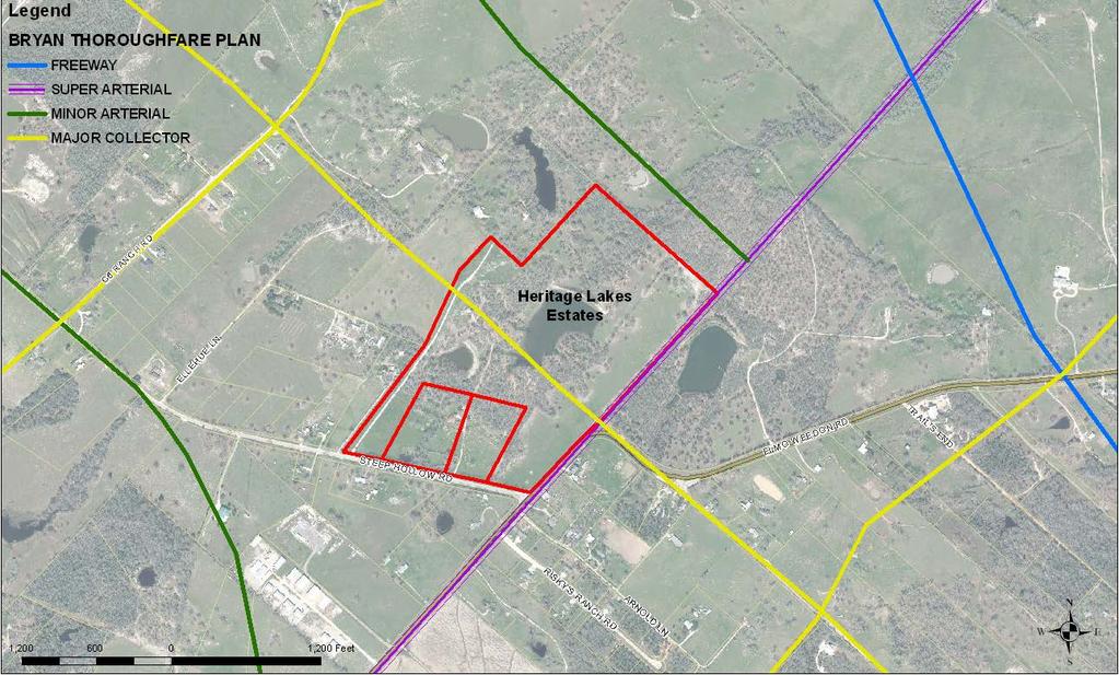
1 ACTION FORM BRYAN CITY COUNCIL DATE OF COUNCIL MEETING: February 25, 2014 DATE SUBMITTED: February 6, 2014 DEPARTMENT OF ORIGIN: Development Services SUBMITTED BY: Martin Zimmerman MEETING TYPE: CLASSIFICATION: ORDINANCE: STRATEGIC INITIATIVE: BCD PUBLIC HEARING 1ST READING PUBLIC SAFETY SPECIAL CONSENT 2ND READING SERVICE REGULAR STATUTORY ECONOMIC DEVELOP. WORKSHOP REGULAR INFRASTRUCTURE QUALITY OF LIFE AGENDA ITEM DESCRIPTION: Consideration of a request to amend the City of Bryan s Thoroughfare Plan, specifically to realign suggested major collector street and super arterial street connections in the area surrounding the intersection of Steep Hollow and Elmo Weedon Roads in Bryan s extraterritorial jurisdiction (ETJ) in eastern Brazos County, Texas. SUMMARY STATEMENT: The City of Bryan Thoroughfare Plan provides a long-term vision of the major street network necessary to meet the future travel needs of the residents of the City of Bryan and the surrounding area. The Thoroughfare Plan was adopted by the City Council with Resolution No in January 2007 as part of the City s Comprehensive Plan. The applicant, Mr. Kyle, is proposing to develop an 83+ acre property located north of the intersection of Elmo Weedon and Steep Hollow Roads into a new rural residential subdivision in the City s extraterritorial jurisdiction (ETJ). The subject property is located approximately 2.7 miles from the City of Bryan corporate limits. The City s current Thoroughfare Plan identifies a future public thoroughfare, classified as a major collector street, to bisect the subject property. In addition, the current Plan envisions a super arterial street to extend along the existing Elmo Weedon Road right-of-way and along the southeast side of the subject property. The applicant is requesting that the City s Thoroughfare Plan be amended to show the proposed major collector street to follow the existing Steep Hollow Road right-of-way and to realign the envisioned super arterial street to follow the existing Elmo Weedon Road right-of-way. STAFF ANALYSIS AND RECOMMENDATION: Staff recommends approving the requested amendment to the City of Bryan s Thoroughfare Plan, as requested. This proposed Thoroughfare Plan amendment preserves thoroughfares for future growth and maximizes the potential of the proposed development as well. While the new alignment of the super arterial will now potentially affect several property owners that were not previously affected and could affect the location and alignment of other thoroughfares in this area, the requested amendment will follow existing improved major roadways in this area (Steep Hollow and Elmo Weedon Roads, respectively) compared to the current alignment, which would require significant land dedication by area property owners and/or right-of-way acquisition by the City of Bryan. The proposed new alignment of Elmo Weedon Road will also improve the safety near its intersection with Steep Hollow Road, where several fatal accidents have occurred. The proposed amendment will allow the proposed development of a rural subdivision to proceed without any significant burden. The Brazos County Engineer has studied the request and concurs with City staff s recommendation in this particular case. During its regular meeting on February 6, 2014, the Planning and Zoning Commission concurred with staff and unanimously recommends approving this request.
2 OPTIONS (In Suggested Order of Staff Preference): 1. approve the requested amendment to the City of Bryan s Thoroughfare Plan 2. approve the request with modifications, which may require consideration at a future City Council meeting 3. deny the request ATTACHMENTS: 1. location map/current Thoroughfare Plan 2. draft resolution 3. excerpt from P&Z meeting minutes 4. staff report to the P&Z FUNDING SOURCE: N/A APPROVALS: Kevin Russell ; Joey Dunn, ; Hugh R. Walker, 02/12/2014 APPROVED FOR SUBMITTAL: CITY MANAGER Kean Register, 2/14/2014 APPROVED FOR SUBMITTAL: CITY ATTORNEY Janis K. Hampton, 2/17/2014 Revised 04/2013

3 LOCATION MAP/CURRENT THOROUGHFARE PLAN:
4 RESOLUTION NO. A RESOLUTION AMENDING THE CITY OF BRYAN THOROUGHFARE PLAN, BEING FIGURE 6-2 OF THE CITY OF BRYAN COMPREHENSIVE PLAN, ADOPTED BY CITY COUNCIL RESOLUTION NO ON JANUARY 9, 2007, TO REALIGN SUGGESTED MAJOR COLLECTOR AND SUPER ARTERIAL STREET CONNECTIONS IN THE AREA SURROUNDING THE INTERSECTION OF STEEP HOLLOW AND ELMO WEEDON ROADS IN BRYAN S EXTRATERRITORIAL JURISDICTION (ETJ) IN BRAZOS COUNTY, TEXAS. WHEREAS, the City of Bryan adopted a new Comprehensive Plan with the adoption of City Council Resolution No on January 9, 2007; and WHEREAS, Figure 6-2 of said Comprehensive Plan is the City of Bryan Thoroughfare Plan that provides a long-term vision of the major street network necessary to meet the future travel needs of the residents of the City of Bryan and the surrounding area; and WHEREAS, the citizens of Bryan require a transportation system that provides mobility in the face of ever-increasing population and traffic; and WHEREAS, the City of Bryan Thoroughfare Plan must be amended periodically to adapt to new patterns of development and changes in existing or expected traffic conditions; and WHEREAS, the proposed development of the Heritage Lakes Estates Subdivision on acres of land out of the Richardson Perry League, located at the north corner of Steep Hollow and Elmo Weedon Roads in Brazos County, Texas, creates a need to adjust the current alignment of proposed thoroughfares shown on the City of Bryan Thoroughfare Plan, to allow for better traffic flow and future development; NOW, THEREFORE, BE IT RESOLVED BY THE CITY COUNCIL OF THE CITY OF BRYAN, TEXAS: Section 1. That the City of Bryan Thoroughfare Plan, being Figure 6-2 of the City of Bryan Comprehensive Plan, adopted by City Council Resolution No on January 9, 2007, is hereby amended to realign suggested major collector street and super arterial street connections in the area surrounding the intersection of Streep Hollow and Elmo Weedon Roads in Bryan s extraterritorial jurisdiction (ETJ) in Brazos County, Texas, as set forth in Exhibit A attached hereto and made a part hereof. Section 2. That this Resolution shall become effective immediately upon adoption. APPROVED and ADOPTED by the City Council of the City of Bryan on this 25 th day of February, ATTEST: CITY OF BRYAN: Mary Lynne Stratta, City Secretary Jason P. Bienski, Mayor
5 APPROVED AS TO FORM: Janis K. Hampton, City Attorney
6 EXHIBIT A : EXISTING THOROUGHFARE PLAN
7

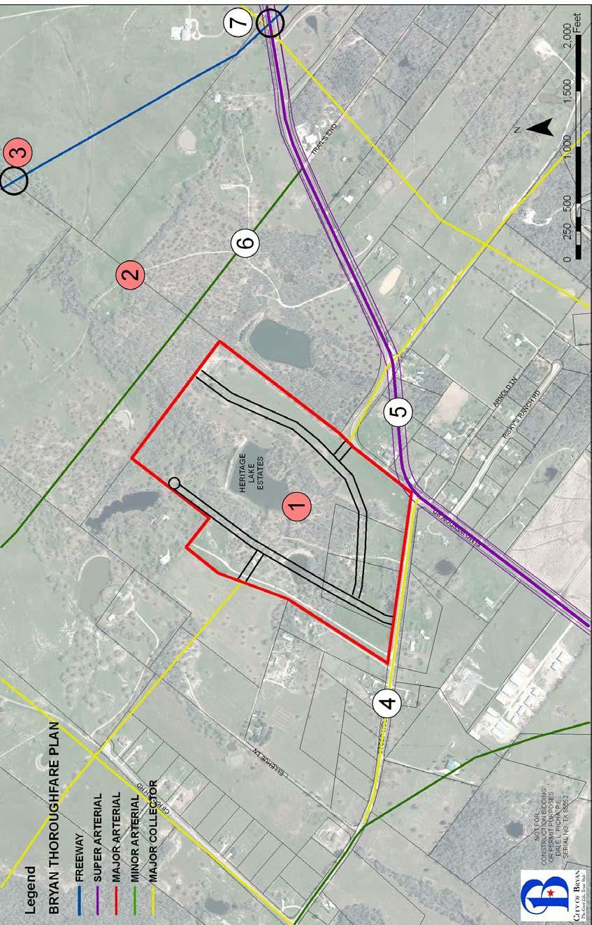
8 EXH IBIT B AME NDE D THO ROU GHF ARE PLA N Ame ndme nts to the City of Brya n Thor ough fare Plan, being Figur e 6-2 of the City of Brya n Com preh ensiv e Plan, as it was adop ted with City Coun cil Resol ution No.
9 3078 on January 9, 2007 Note #1 major collector removed Note #2 super arterial removed north of Steep Hollow Road Note #3 future interchange removed Note #4 major collector added to follow Steep Hollow Road alignment Note #5 super arterial added to follow Elmo Weedon Road alignment (min. curve radii approx. 1,000ft. per AASHTO) Note #6 minor arterial amended to extend to Elmo Weedon Road (to new super arterial alignment) Note #7 proposed interchange added
10 EXCERPT FROM PLANNING AND ZONING COMMISSION REGULAR MEETING MINUTES OF FEBRUARY 6, 2014: 9. REQUESTS RELATED TO THE PROPOSED HERITAGE LAKES ESTATES SUBDIVISION ON ACRES OF VACANT LAND LOCATED AT THE NORTH CORNER OF STEEP HOLLOW AND ELMO WEEDON ROADS IN BRYAN S EXTRATERRITORIAL JURISDICTION (ETJ) IN BRAZOS COUNTY, TEXAS. A PUBLIC HEARING WILL BE HELD FOR EACH ITEM (Commission makes recommendation concerning the Comprehensive Plan amendment; City Council has final approval; Commission has final approval concerning master plan and planning exception). a. Comprehensive Plan Amendment CPA14-01: Heritage Lakes Estates Subdivision A request to amend the City of Bryan s Thoroughfare Plan, specifically to realign suggested major collector street and super arterial street connections in the area surrounding the intersection of Steep Hollow Road and Elmo Weedon Road. (M. Zimmermann) Mr. Zimmermann presented the staff report (on file in the Development Services Department). Staff recommends approval of the proposed comprehensive plan amendment. The public hearing was opened. Mr. Joe Schultz, 2730 Longmire Drive, College Station, Texas, project engineer, came forward as to make himself available for questions. The public hearing was closed. Commissioner Gutierrez moved to recommend approval of Comprehensive Plan Amendment CPA14-01 to the Bryan City Council, and to adopt the written staff report and analysis, as the report, findings and evaluation of this Commission. Commissioner Bienski seconded the motion. Commissioners discussed: that this change makes sense flexibility in planning commending the applicant and city staff working together on a solution The motion passed unanimously.
: AGENT: a request to amend the City of Bryan s Thoroughfare Plan, specifically to realign")

11 PLANNING AND ZONING COMMISSION STAFF REPORT February 6, 2014 Comprehensive Plan Amendment CPA14-01: Heritage Lakes Estates Subdivision LOCATION: APPLICANT(S): AGENT: a request to amend the City of Bryan s Thoroughfare Plan, specifically to realign suggested major collector street and super arterial street connections in the area surrounding the intersection of Steep Hollow Road and Elmo Weedon Road Don Kyle for Kyle Family Living Trust Joe Schultz of Schultz Engineering, LLC LOCATION AND CURRENT THOROUGHFARE PLAN:
12 BACKGROUND: The applicant, Mr. Kyle, is proposing to develop an 83+ acre property located north of the intersection of Elmo Weedon and Steep Hollow Roads into a new rural residential subdivision in the City s extraterritorial jurisdiction (ETJ). The subject property is located approximately 2.7 miles from the City of Bryan corporate limits. The City s current Thoroughfare Plan, which was adopted by the City Council in January 2007 as part of the City s Comprehensive Plan, identifies a future public thoroughfare, classified as a major collector street, to bisect the subject property. Thoroughfares classified as major collector streets typically have a right-of-way width of 80 feet and pavement widths of 54 feet. The current Thoroughfare Plan places this envisioned major collector street through the subject property and through a 5-acre lake on the property around which the applicant is proposing to develop a new low-density residential subdivision. The applicant is requesting that the Thoroughfare Plan be amended to show the proposed major collector street to follow the existing Steep Hollow Road right-of-way. The existing Steep Hollow Road right-ofway measures approximately 85 feet in width with a pavement width of 35 feet. Secondly, Mr. Kyle is requesting to amend the Thoroughfare Plan with regard to a super arterial street which is currently envisioned to extend along the existing Elmo Weedon Road right-of-way and along the southeast side of the subject property. Typically, thoroughfares classified as super arterial streets should have a right-of-way width of 120 feet with a pavement width of 96 feet. The current alignment places the super arterial along the southeast side of the subject property along the existing Elmo Weedon Road rightof-way. Approximately 665 feet north of the intersection of Elmo Weedon and Steep Hollow Roads, Elmo Weedon Road turns 90 degrees to the east. The current alignment of the super arterial does not follow the Elmo Weedon Road right-of-way at this point, but continues north following the subject property s southeastern property line. The proposed realignment would have the super arterial generally following the existing Elmo Weedon Road right-of-way to the east and then back again north. However, instead of a hard eastern turn along the existing Elmo Weedon Road right-of-way, the new alignment would be a gradual turn east and then north again consistent with American Association of State Highway and Transportation Officials (AASHTO) design criteria. The new alignment will bisect five properties on the east side of Elmo Weedon Road. Please see the notes and graphic below and for further explanation. PROPOSED AMENDMENTS TO THE THOROUGHFARE PLAN: (Note: Bold Note denotes a removal on the Thoroughfare Plan) Note #1 major collector removed Note #2 super arterial removed north of Steep Hollow Road Note #3 future interchange removed Note #4 major collector added to follow Steep Hollow Road alignment Note #5 super arterial added to follow Elmo Weedon Road alignment (min. curve radii approx. 1,000ft. per AASHTO) Note #6 minor arterial amended to extend to Elmo Weedon Road (to new super arterial alignment) Note #7 proposed interchange added
13
14 Acting on behalf of the general public, only the City Council is authorized to officially amend the City of Bryan s Thoroughfare Plan through a Comprehensive Plan amendment. The Planning and Zoning Commission hears and makes a recommendation on proposals to amend the Thoroughfare Plan. ANALYSIS: The primary advantages of the proposed new alignment are that both the major collector and the super arterial will follow existing improved major roadways in this area (Steep Hollow and Elmo Weedon Roads, respectively) compared to the current alignment which would require significant land dedication by area property owners and/or right-of-way acquisition by the City of Bryan. The proposed new alignment of Elmo Weedon Road will also improve the safety near its intersection with Steep Hollow Road, where several fatal accidents have occurred in the past. The proposed amendment will allow the proposed development of a rural subdivision to proceed without any significant burden. Potential disadvantages to the proposal include that the new alignment of the super arterial now will affect several property owners that were not previously affected and could affect the location and alignment of other thoroughfares in this area. The ultimate alignment of the new super arterial as it approaches the County Line to the northeast is still to be determined and will require further study. RECOMMENDATION: Staff recommends approving the requested amendment to the City of Bryan s Thoroughfare Plan, as presented. This proposed Thoroughfare Plan amendment preserves thoroughfares for future growth and maximizes the potential of the proposed development as well. The Brazos County Engineer has studied the request and concurs with City staff s recommendation in this particular case.
Town of Flower Mound Master Transportation Plan Update
 Town of Flower Mound Master Transportation Plan Update Town Council January 5, 2009 Agenda Project Schedule Why we re here Recommended Changes to MTP; plus: Transportation Commission Recommendations (11/11/08)
Staff Report Text Amendment Case #: TA
 Staff Report Text Amendment Case #: TA 2017 03 00005 Attachments: Staff Report, Current Code Planning Commission Public Hearing: Thursday, April 6, 2017 City Council Introduction: Tuesday April 11, 2017
Residential Traffic Calming Handbook
 Residential Traffic Calming Handbook How to calm excessive traffic and speeding in residential areas Public Works Department Traffic Services Division 1 Hillsborough County Residential Traffic Calming
ORDINANCE NO AMENDMENT TO ORDINANCE NO NASSAU COUNTY, norida. WHEREAS, on the 28th day of January, 1991, the Board of County
 ORDINANCE NO. 99-23 AMENDMENT TO ORDINANCE NO. 91-04 NASSAU COUNTY, norida WHEREAS, on the 28th day of January, 1991, the Board of County Commissioners, Nassau County, Florida (the "Board"), did adopt
This Chapter sets forth the minimum design, technical criteria and specifications to be used in the preparation of all roadway plans.
 4.1 GENERAL This Chapter sets forth the minimum design, technical criteria and specifications to be used in the preparation of all roadway plans. These Roadway Standards are for new construction and modification
MAJOR THOROUGHFARE PLAN
 MAJOR THOROUGHFARE PLAN Adopted by City Commission On November 21, 2005 Per Resolution No. 4420 Amendment to the Comprehensive Community Development Plan City of Hobbs City of Hobbs MAJOR THOROUGHFARE
Adopt Resolution to declare the intent of the City Council to vacate Worthington Street to allow for the widening of Laurel Street.
 TO: FROM: SUBJECT: Kent Studebaker, Mayor Members of the City Council Erica Rooney, PE, City Engineer Engineering Department Resolution 15 05 Declaring the City s intent to Vacate Worthington Street, Dedicate
TOWN OF CHAPEL HILL POLICY AND PROCEDURES FOR TRAFFIC CALMING MEASURES
 TOWN OF CHAPEL HILL POLICY AND PROCEDURES FOR TRAFFIC CALMING MEASURES (Adopted by the Town Council on June 30, 2004) (Revised December 6, 2010) (Revised February 8, 2016) POLICY AND PROCEDURES FOR TRAFFIC
Exhibit 1 PLANNING COMMISSION AGENDA ITEM
 Exhibit 1 PLANNING COMMISSION AGENDA ITEM Project Name: Grand Junction Circulation Plan Grand Junction Complete Streets Policy Applicant: City of Grand Junction Representative: David Thornton Address:
Access Management Regulations and Standards for Minor Arterials, Collectors, Local Streets
 Access Management Regulations and Standards for Minor Arterials, Collectors, Local Streets September 2009 Paul Grasewicz Access Management Administrator Concept of Access Management The way to manage access
MASTER THOROUGHFARE PLAN
 MASTER THOROUGHFARE PLAN Master Thoroughfare Plan Update November 2015 Prepared for Town of Northlake AVO 30659 11/11/2015 1201 North Bowser Road Richardson, Texas 75081 Firm Registration No. 312 MASTER
COUNCIL COMMUNICATION
 Meeting Date: March 20, 2018 COUNCIL COMMUNICATION Agenda Item: Agenda Location: Action Items Work Plan # Legal Review: 1 st Reading 2 nd Reading Subject: A resolution approving the final design for the
SAN FRANCISCO MUNICIPAL TRANSPORTATION AGENCY
 THIS PRINT COVERS CALENDAR ITEM NO. : 10.3 DIVISION: Sustainable Streets Division BRIEF DESCRIPTION: SAN FRANCISCO MUNICIPAL TRANSPORTATION AGENCY Approving traffic and parking modifications to install
ORDINANCE NO AN ORDINANCE MAKING CERTAIN FINDINGS AND ESTABLISHING THE MALL REDEVELOPMENT DISTRICT
 Introduced: January 20, 2015 Passed: January 20, 2015 Published: January 23, 2015 ORDINANCE NO. 2015-2 AN ORDINANCE MAKING CERTAIN FINDINGS AND ESTABLISHING THE MALL REDEVELOPMENT DISTRICT WHEREAS, K.S.A.
ORDINANCE NO. SB-3131
 ORDINANCE NO. SB-3131 AN ORDINANCE MAKING FINDINGS AND ESTABLISHING A STAR BOND PROJECT DISTRICT WITHIN THE CITY OF OVERLAND PARK, KANSAS PURSUANT TO K.S.A. 12-17,160 ET SEQ., AS AMENDED (BLUHAWK STAR
BOARD OF ALDERMEN AGENDA
 NOTICE OF MEETING CITY OF BRANSON BOARD OF ALDERMEN Special Meeting Thursday, March 10, 2016 5:00 p.m. Council Chambers Branson City Hall 110 W. Maddux Meeting Called to Order Roll Call AGENDA REGULAR:
ACHD Board of Commissioners Stacey Yarrington, Planner III Tandem Ridge/ EPP / PP-07-16/ RZ-12-16/ CPA-01-16/ A-07-16
 Development Services Department DATE: December 14, 2016 TO: FROM: SUBJECT: ACHD Board of Commissioners Stacey Yarrington, Planner III Tandem Ridge/ EPP16-0012/ PP-07-16/ Executive Summary: This is an annexation,
This page intentionally left blank.
 This page intentionally left blank. COMMUNITY Coweta Community Overview Coweta Coweta, a residential community located in Wagoner County, is a suburb of Tulsa situated southeast of the metropolitan area
Chapter 5 FUNCTIONAL CLASSIFICATION
 Chapter 5 FUNCTIONAL CLASSIFICATION Functional classification is a system by which streets and roadways may be distinguished by types according to their function within the entire transportation network.
City of Homewood Transportation Plan
 City of Homewood Transportation Plan Prepared for: City of Homewood, Alabama Prepared by: Skipper Consulting, Inc. May 2007 TABLE OF CONTENTS INTRODUCTION... 1 BACKGROUND INFORMATION... 1 EXISTING TRANSPORTATION
T A B L E OF C O N T E N T S
 T A B L E OF C O N T E N T S PART III SUBDIVISION REGULATIONS OF THE DEPARTMENT OF PUBLIC WORKS, C & C D PAGE PAGE Responsibility for Development of Streets......... 29 Right-of-Way Widths...... 37 Purpose...........
Spartanburg County Planning and Development Department
 Spartanburg County Planning and Development Department MINUTES Planning and Development Commission County Council Chambers, 4:30 p.m. August 8, 2017 Members Present: Whit Kennedy, Chairman Toby McCall,
APPENDIX G: INTERSECTION NEEDS AT OKEECHOBEE BOULEVARD
 APPENDIX G: INTERSECTION NEEDS AT OKEECHOBEE BOULEVARD INTERSECTION NEEDS AT SR 7 and OKEECHOBEE BOULEVARD SR 7 Extension Project Development and Environment (PD&E) Study From Okeechobee Boulevard (SR
Access Management Regulations and Standards
 Access Management Regulations and Standards Efficient highway operation Reasonable property access Concept of Access Management The way to manage access to land development while simultaneously preserving
CITY OF SASKATOON COUNCIL POLICY
 ORIGIN/AUTHORITY Clause 1, Report No. 1-1980 and Clause 4, Report No. 22-1990 of the Works and Utilities Committee; Clause 6, Report No. 17-2004 of the Planning and Operations Committee; and Clause D5,
Roadway Classification Design Standards and Policies. Pueblo, Colorado November, 2004
 Roadway Classification Design Standards and Policies Pueblo, Colorado November, 2004 Table of Contents Page Chapter 1. General Provisions 1.1 Jurisdiction 3 1.2 Purpose and Intent 3 1.3 Modification 3
LARIMER COUNTY: ENGINEERING DOUGLAS ROAD (CR 54)
") LARIMER COUNTY: ENGINEERING DOUGLAS ROAD (CR 54) INTRODUCTIONS * Pipeline 1041 Application Coordinator Todd Blomstrom Public Works Director Mark Peterson County Engineer Terry Gilbert Community Development
LARIMER COUNTY: ENGINEERING DOUGLAS ROAD (CR 54) INTRODUCTIONS * Pipeline 1041 Application Coordinator Todd Blomstrom Public Works Director Mark Peterson County Engineer Terry Gilbert Community Development
CITY OF LUCAS 2014 MASTER THOROUGHFARE PLAN
 INTRODUCTION CITY OF LUCAS 2014 MASTER THOROUGHFARE PLAN A thoroughfare system is intended to provide an effective means of moving vehicles within and through a city. The thoroughfare plan will assist
AGENDA REPORT. Issue: Discussion of potential improvements on Barnwell Road at Niblick Drive
 AGENDA REPORT To: From: By: Honorable Mayor and City Council Members Warren Hutmacher, City Manager Tom Black, Public Works Director Date: March 23, 2016 Agenda: March 28, 2016 WORK SESSION AGENDA: Barnwell
Roadway Classification Review
 District of North Vancouver 355 West Queens Road North Vancouver British Columbia V7N 4N5 Roadway Classification Review District of North Vancouver January 2013 District of North Vancouver Roadway Classification
APPROVE A RESOLUTION ADOPTING A COMPLETE STREETS POLICY
 STAFF REPORT MEETING DATE: September 13, 2016 TO: FROM: City Council Bob Brown, Community Development Director Russ Thompson, Public Works Director Patrick Filipelli, Management Analyst 922 Machin Avenue
Access Management Regulations and Standards
 Access Management Regulations and Standards January 2014 Efficient highway operation Reasonable property access Concept of Access Management The way to manage access to land development while preserving
INTRODUCTION THOROUGHFARE SYSTEM CLASSIFICATIONS
 INTRODUCTION The thoroughfare plan will assist public officials in the development of a specialized system for efficient and safe movement of vehicular traffic while minimizing potential conflicts with
Report. Typical Sections. City of Middleton, WI
 Report Typical Sections City of Middleton, WI December 2006 Report for City of Middleton, Wisconsin Typical Sections repared by: Traffic Associates LLC and STRAND ASSOCIATES, INC. 910 West Wingra Drive
Urban Planning and Land Use
 Urban Planning and Land Use 701 North 7 th Street, Room 423 Phone: (913) 573-5750 Kansas City, Kansas 66101 Fax: (913) 573-5796 Email: planninginfo@wycokck.org www.wycokck.org/planning To: From: City Planning
FORT MYERS CITY COUNCIL AGENDA ITEM SUMMARY
 MEETING DATE: October 3, 2011 Regular Special Workshop Proclamations & Special Presentations Consent Public Hearings MOTION: Adopt resolution initiating the process of developing guidelines, processes,
Recommended Roadway Plan Section 2 - Land Development and Roadway Access
 Recommended Roadway Plan Section 2 - Land Development and Roadway Access SECTION 2 Land Development and Roadway Access 2.1 Land Use and Access Management The Federal Highway Administration (FHWA) defines
NEW YORK CENTRAL PARK SUBDIVISION BLAIS STREET/ST-PIERRE STREET EMBRUN, ONTARIO TRAFFIC IMPACT STUDY. Prepared for:
 NEW YORK CENTRAL PARK SUBDIVISION BLAIS STREET/ST-PIERRE STREET EMBRUN, ONTARIO TRAFFIC IMPACT STUDY Prepared for: Solidex Holdings Limited & Investissement Maurice Lemieux Investments Attn: Mr. Anthony
1/9/2018. City Council City Hall Wilmington, North Carolina Dear Mayor and Councilmembers:
 ITEM O2 OFFICE OF THE CITY MANAGER (910) 341-7810 FAX (910)341-5839 TDD (910)341-7873 1/9/2018 City Council City Hall Wilmington, North Carolina 28401 Dear Mayor and Councilmembers: On March 21, 2017,
CITY OF VAUGHAN EXTRACT FROM COUNCIL MEETING MINUTES OF NOVEMBER 21, 2017
 CITY OF VAUGHAN EXTRACT FROM COUNCIL MEETING MINUTES OF NOVEMBER 21, 2017 Item 9, Report No. 39, of the Committee of the Whole, which was adopted without amendment by the Council of the City of Vaughan
TRAFFIC CALMING POLICY & PROCEDURES
 TRAFFIC CALMING POLICY & PROCEDURES AS ADOPTED BY MONTCLAIR TOWNSHIP COUNCIL AUGUST 4, 2009 TABLE OF CONTENTS 1. INTRODUCTION... 2 Purpose... 2 Traffic Calming Definition... 2 Statement Of Township Council
MEMORANDUM TERESA MCCLISH, COMMUNITY DEVELOPMENT DIRECTOR
 MEMORANDUM TO: FROM: BY: CITY COUNCIL TERESA MCCLISH, COMMUNITY DEVELOPMENT DIRECTOR MATTHEW DOWNING, PLANNING MANAGER SUBJECT: CONSIDERATION OF TEMPORARY USE PERMIT CASE NO. 18-015; AUTHORIZING THE VILLAGE
CITY OF BONITA SPRINGS ZONING ORDINANCE NO
 CITY OF BONITA SPRINGS ZONING ORDINANCE NO. 05-07 A ZONING ORDINANCE OF THE CITY OF BONITA SPRINGS, FLORIDA; APPROVING A REQUEST BY BONITA FAIRWAYS RPD/MHPD TO AMEND THE MASTER CONCEPT PLAN TO DESIGNATE
Policy Number: Effective: 07/11/14 Responsible Division: Planning Date: 07/11/2014 FUNCTIONAL CLASSIFICATION AMENDMENT POLICY
 Policy Number: 2014-025 Effective: 07/11/14 Responsible Division: Planning Date: 07/11/2014 FUNCTIONAL CLASSIFICATION AMENDMENT POLICY POLICY STATEMENT: The Northeast Ohio Areawide Coordinating Agency
NEW BRAUNFELS SEGUIN AREA REGIONAL TRANSPORTATION DRAFT PLAN NEW BRAUNFELS CITY COUNCIL MEETING
 NEW BRAUNFELS SEGUIN AREA REGIONAL TRANSPORTATION DRAFT PLAN NEW BRAUNFELS CITY COUNCIL MEETING February 13, 2012 This regional transportation plan will: 1. Review existing plans for the cities and counties,
Third Street Bridge & Corridor Project
 Third Street Bridge & Corridor Project Preparation for the FY2018 budget to commence October 1, 2017, includes funding to address a project that has been considered since 1994. The Third Street bridge
Draft MOBILITY ELEMENET. Community Meeting May 22, 2013
 Draft MOBILITY ELEMENET Community Meeting May 22, 2013 Agenda Presentation Ira Brown New Mobility Paradigm Movement of People Implementation Q&A Ira Brown and Dave Roseman Small Group Discussion at Each
Access requests to County streets and roadways are processed through one of the following methods:
 13.1 GENERAL APPLICATION PROCESS Access requests to County streets and roadways are processed through one of the following methods: A. Planned Developments may set general locations for access points.
Traffic Calming Policy
 Article I. Purpose and Goal. The purpose of this policy is to establish criteria and procedures the City will use to evaluate requests for, and if appropriate, implement traffic calming measures. Neighborhood
City of Tamarac, Florida Traffic Calming Policy
 City of Tamarac, Florida Traffic Calming Policy Temp. Reso. 12614 Exhibit 1 I. Introduction: The City of Tamarac recognizes that the conditions of residential streets can greatly affect neighborhood livability
CHAPTER 7 CIRCULATION
 CHAPTER 7 CIRCULATION A township s transportation network links its population with the surrounding communities. Transportation networks, including public and private, provide the means by which township
RESOLUTION NO A RESOLUTION OF THE CITY COUNCIL OF THE CITY OF MENLO PARK ADOPTING A COMPLETE STREETS POLICY
 RESOLUTION NO. 6123 A RESOLUTION OF THE CITY COUNCIL OF THE CITY OF MENLO PARK ADOPTING A COMPLETE STREETS POLICY WHEREAS, the term Complete Streets describes a comprehensive, integrated transportation
City Council Agenda Item #6-A CITY OF ALAMEDA Memorandum. To: Honorable Mayor and Members of the City Council. John A. Russo City Manager
 CITY OF ALAMEDA Memorandum To: From: Honorable Mayor and Members of the City Council John A. Russo City Manager Date: January 14, 2013 Re: Adopt a Resolution Approving a Complete Streets Policy, in Accordance
West Dimond Blvd Upgrade Jodhpur Street to Sand Lake Road
 West Dimond Blvd Jodhpur St to Sand Lake CSS Transportation Project Summary Municipality of Anchorage Project # 05 005 Project Manager: John Smith, P.E. (MOA PM&E) Project Administrator: Julie Makela,
Circulation in Elk Grove includes: Motor vehicles, including cars and trucks
 Circulation, as it is used in this General Plan, refers to the many ways people and goods move from place to place in Elk Grove and the region. Circulation in Elk Grove includes: Motor vehicles, including
WHEREAS, the New Jersey Department of Transportation' s Complete Streets
 WHEREAS, the State Department of Transportation adopted a Complete Streets Policy ( Policy No. 703), effective December 3, 2009, for all projects funded through the Department' s Capital Program and strongly
#!! "$% ##! &! # '#! % $ #!
 Executive Summary US Highway 16 (US 16) is the primary corridor connecting Rapid City to the Black Hills region. It serves a growing population of commercial and residential traffic, as well as seasonal
ENGINEERING MEMORANDUM
 ENGINEERING MEMORANDUM January 8, 2018 TO: FROM: SUBJECT: City Council Mike Payne, City Engineer RECOMMENDATIONS OF THE TRANSPORTATION COMMITTEE: Second reading and public hearing on a proposed ordinance
5.0 Roadway System Plan
 Southwest Boise Transportation Study Page 16 5.0 Roadway System Plan The Roadway System Plan outlines roadway improvements in the Initial Study Area. It forecasts future deficiencies on the arterial system,
Street Paving and Sidewalk Policy
 City Commission Policy 600 Street Paving and Sidewalk Policy DEPARTMENT: Public Works DATE ADOPTED: June 7, 1995 DATE OF LAST REVISION: December 10, 2014 Policy No. 600.01 AUTHORITY: PASS City of Tallahassee-Leon
DRAFT BUENA VISTA 2020 TRANSPORTATION PLAN
 DRAFT BUENA VISTA 2020 TRANSPORTATION PLAN DEVELOPED BY THE TRANSPORTATION PLANNING DIVISION OF THE VIRGINIA DEPARTMENT OF TRANSPORTATION IN COOPERATION WITH THE U.S. DEPARTMENT OF TRANSPORTATION, FEDERAL
ORDINANCE NO AMENDMENT TO THE CITATION ESTATES MPD DEVELOPMENT AGREEMENT
 ORDINANCE NO. 2015- AMENDMENT TO THE CITATION ESTATES MPD DEVELOPMENT AGREEMENT AN ORDINANCE OF THE CITY COUNCIL OF THE CITY OF PALM COAST, FLORIDA, PROVIDING FOR THE SECOND AMENDED AND RESTATED MASTER
A5.1 Permitted activities
 Section A5 Transportation A5.1 Permitted activities A5.1.1 Activities within roads Note: Refer to Section D for the definition of road (a) Any activity associated with the movement of traffic and the functioning
 Development Services Department Project/File: Lead Agency: Site address: Fall Creek Subdivision (MPP-12-016) This is a preliminary plat application to subdivision approximately 110 acres into 296 residential
SAN FRANCISCO MUNICIPAL TRANSPORTATION AGENCY
 THIS PRINT COVERS CALENDAR ITEM NO. : 11 DIVISION: Sustainable Streets BRIEF DESCRIPTION: SAN FRANCISCO MUNICIPAL TRANSPORTATION AGENCY Approving traffic modifications on Twin Peaks Boulevard between Christmas
PLEASE MUTE MOBILE PHONES
 PLEDGE OF ALLEGIANCE MAYOR CITIZENS' REMARKS AND COMMENTS CLOSE CITIZENS NIGHT MEETING PLEASE MUTE MOBILE PHONES CITIZENS' NIGHT AUGUST 9, 2018 MEETING CALLED TO ORDER ROLLCALL AGENDA SETTING MEETING AUGUST
CITY OF LOS ALTOS CITY COUNCIL MEETING May 10, 2016
 CITY OF LOS ALTOS CITY COUNCIL MEETING May 10, 2016 CONSENT CALENDAR Agenda Item # 6 SUBJECT: Adopt Resolution No. 2016-09, approving Engineering and Traffic Surveys at 26 street segments in Los Altos;
TRASBURG RANSPORTATION
 TRASBURG RANSPORTATION LAN DEVELOPED BY THE TRANSPORTATION PLANNING DIVISION OF THE VIRGINIA DEPARTMENT OF TRANSPORTATION IN COOPERATION WITH THE U.S. DEPARTMENT OF TRANSPORTATION, FEDERAL HIGHWAY ADMINISTRATION
3.1 TRAFFIC CALMING PROCESS SUMMARY
 SECTION 3 3.0 TRAFFIC CALMING 3.1 TRAFFIC CALMING PROCESS SUMMARY Traffic calming is a means in which to reduce speeds and minimize vehicular traffic on local neighborhood streets. Citizen involvement
NEIGHBOURHOOD TRAFFIC COMMITTEE POLICY AND PROCEDURE
 The City of Vaughan 2141 Major Mackenzie Drive Vaughan, Ontario Canada L6A 1T1 Tel (905) 832-2281 NEIGHBOURHOOD TRAFFIC COMMITTEE POLICY AND PROCEDURE REVISED JUNE 2010 APPLICABILITY The Neighbourhood
Berwick Health and Education Precinct: Casey Amendment C207 (Part 1) Submission to Planning Panels Victoria
 Submission to Planning Panels Victoria") Berwick Health and Education Precinct: Casey Amendment C207 (Part 1) Submission to Planning Panels Victoria August 2018 CONTENTS 1 Executive summary... 1 2 Summary of the amendment... 2 3 Submission...
Berwick Health and Education Precinct: Casey Amendment C207 (Part 1) Submission to Planning Panels Victoria August 2018 CONTENTS 1 Executive summary... 1 2 Summary of the amendment... 2 3 Submission...
RURAL HIGHWAY SHOULDERS THAT ACCOMMODATE BICYCLE AND PEDESTRIAN USE (TxDOT Project ) June 7, Presented by: Karen Dixon, Ph.D., P.E.
 June 7, Presented by: Karen Dixon, Ph.D., P.E.") RURAL HIGHWAY SHOULDERS THAT ACCOMMODATE BICYCLE AND PEDESTRIAN USE (TxDOT Project 0-6840) June 7, 2016 Presented by: Karen Dixon, Ph.D., P.E., TTI Team: Kay Fitzpatrick, Raul Avelar, & Subasish Das Project
RURAL HIGHWAY SHOULDERS THAT ACCOMMODATE BICYCLE AND PEDESTRIAN USE (TxDOT Project 0-6840) June 7, 2016 Presented by: Karen Dixon, Ph.D., P.E., TTI Team: Kay Fitzpatrick, Raul Avelar, & Subasish Das Project
Capital Region Council of Governments
 March 23, 2018 Capital Region Council of Governments PROJECT CONCEPT REPORT Realignment of Swamp and Northfield Road s approaches to Route 44 (Boston Turnpike) Town of Coventry SUMMARY: The Town of Coventry
Owl Canyon Corridor Project Overview and Summary
 Owl Canyon Corridor Project Overview and Summary December 22, 2008 The Owl Canyon corridor (generally the connection between the I-25 / Larimer County Road 70 interchange and the US 287 / Larimer County
ARTINSVILLE ENRY OUNTY REA RANSPORTATION TUDY
 ARTINSVILLE ENRY OUNTY REA RANSPORTATION TUDY DEVELOPED BY THE TRANSPORTATION AND MOBILITY PLANNING DIVISION OF THE VIRGINIA DEPARTMENT OF TRANSPORTATION IN COOPERATION WITH THE U.S. DEPARTMENT OF TRANSPORTATION,
TRAFFIC IMPACT STUDY. Creekside Thornton, Colorado. For. August 2015 November 2015 Revised: August Prepared for:
 TRAFFIC IMPACT STUDY For Creekside Thornton, Colorado August 215 November 215 Revised: August 216 Prepared for: Jansen Strawn Consulting Engineers 45 West 2 nd Avenue Denver, Colorado 8223 Prepared by:
CHAPTER 4: IDENTIFICATION OF ROAD SYSTEM DEFICIENCIES: TRANSPORTATION PLANNING MODEL
 CHAPTER 4: IDENTIFICATION OF ROAD SYSTEM DEFICIENCIES: TRANSPORTATION PLANNING MODEL I. INTRODUCTION Transportation planning models are the primary tools used to predict future travel conditions. With
Fields of St. Croix HOA Meeting. October 27, 2016
 Fields of St. Croix HOA Meeting October 27, 2016 Welcome! Why are we here? Update on Manning Avenue Phase 2 Project: Project Design Schedule Project Background Importance of Manning Avenue: Primary north-south
BUSINESS OF THE CITY COUNCIL CITY OF MERCER ISLAND, WA
 BUSINESS OF THE CITY COUNCIL CITY OF MERCER ISLAND, WA AB 4087 May 1, 2006 Regular Business PEAK PROJECT UPDATE - CITY RELATED ISSUES Proposed Council Action: Receive update. No action required. DEPARTMENT
D E V I A T I O N R E V I E W A N D D E C I S I O N F O R M
 Development Services Department 2880 International Circle Colorado Springs, Colorado 80910 Phone: 719.520.6300 Fax: 719.520.6695 Website www.elpasoco.com D E V I A T I O N R E V I E W A N D D E C I S I
SANTA CRUZ COUNTY BOARD OF SUPERVISORS INDEX SHEET
 SANTA CRUZ COUNTY BOARD OF SUPERVISORS INDEX SHEET Creation Date: 1 O/l 0/07 Source Code: PUBWK Agenda Date: 10/16/07 I NVENUM : 59879 Resolution( s) : Ordinance(s): Contract (s) : Continue Date(s): [I]
City of Memphis On-Street Parking Modification Guidelines
 City of Memphis Effective Date: December 1, 2013 Bicycle/Pedestrian Program 125 N. Main Street Memphis, TN 38103 (901) 576-6710 www.bikepedmemphis.com City of Memphis Executive Summary It is current practice
ORDINANCE NO
 ORDINANCE NO. 09062016-01 AN ORDINANCE AMENDING ORD NO.7-7-98 (ORD NO. 09-04-01, ORD NO. 03-05-02, ORD NO. 05-11-04, ORD NO. 110607-01, ORD NO. 04072009-01, ORD NO. 10252011-02, AND ORD NO. 08122013-05)
CITY OF NORTH OLMSTED ORDINANCE NO
 CITY OF NORTH OLMSTED ORDINANCE NO. 2014 64 BY: Mayor Kennedy AN ORDINANCE AMENDING SECTION 505.10 OF THE GENERAL OFFENSES CODE OF THE CITY OF NORTH OLMSTED ENTITLED HUNTING PROHIBITED TO ALLOW THE CITY
TRANSPORTATION COMMISSION East 19 th St, Harper to O Connell Thursday, March 29, :00 PM City Commission Room, City Hall, 6 E.
 TRANSPORTATION COMMISSION East 19 th St, Harper to O Connell Thursday, March 29, 2018 6:00 PM City Commission Room, City Hall, 6 E. 6th Street AGENDA Public comment related to the meeting topic will be
AGENDA REPORT SUMMARY. Ordinance : Amending the Los Altos Municipal Code Reassigning Commission Responsibility for Transportation Issues
 CONSENT CALENDAR Agenda Item #3 Meeting Date: September 12, 2017 AGENDA REPORT SUMMARY Subject: Prepared by: Chris Jordan, City Manager Attachment: 1. Ordinance 2017-434 Initiated by: The City Council
ORDINANCE NO WHEREAS, An Eighty (80) foot portion of Sheffield Avenue lies between the
 foot portion of Sheffield Avenue lies between the") SPONSOR: Councilman Mark Kalwinski 1 st District Councilman PETITIONED BY: Hammond Port Authority ORDINANCE NO. 9284 AN ORDINANCE VACATING AN EIGHTY (80) FOOT PORTION OF SHEFFIELD AVENUE LYING BETWEEN
SPONSOR: Councilman Mark Kalwinski 1 st District Councilman PETITIONED BY: Hammond Port Authority ORDINANCE NO. 9284 AN ORDINANCE VACATING AN EIGHTY (80) FOOT PORTION OF SHEFFIELD AVENUE LYING BETWEEN
SECTION 3 STREET DESIGN
 3.01 GENERAL SECTION 3 STREET DESIGN For purposes of geometric and structural design, streets shall be classified according to the following table. The City Engineer will determine the class of all proposed
TABLE OF CONTENTS. Executive Summary
 Executive Summary Background... ES-1 Pedestrian Network... ES-2 Bikeway Network... ES-2 Collision History... ES-2 Public Input... ES-4 Conclusions and Recommendations... ES-4 1. Introduction and Setting
SECTION 8.0 HIGHWAY SETBACK LINES & ROADSIDE REGULATIONS
 SECTION 8.0 HIGHWAY SETBACK LINES & ROADSIDE REGULATIONS 8.1 Classification and Setbacks For the purpose of determining the distance buildings and other structures are set back, the roads and highways
Committed to Service
 Development Services Department Committed to Service TO: FROM: Ada County Highway District Commissioners Mindy Wallace, AICP Planner III COMISSION HEARING: January 27, 2016 SUBJECT: Syringa Valley Specific
Classification Criteria
 SCHEDULE D TO RECOMMENDED OFFICIAL PLAN AMENDMENT NO. 40 SCHEDULE C-4 Road Criteria Criteria Traffic Service Objective Land Service/Access Typical Daily Traffic Volume Flow characteristics Travel Speed
Corporate. Report COUNCIL DATE: June 26, 2006 NO: C012 COUNCIL-IN-COMMITTEE. TO: Mayor & Council DATE: June 22, 2006
 Corporate NO: C012 Report COUNCIL DATE: June 26, 2006 COUNCIL-IN-COMMITTEE TO: Mayor & Council DATE: June 22, 2006 FROM: General Manager, Engineering FILE: 0410-20(MoT/Gate) SUBJECT: Surrey Response on
Citizens Handbook for Requesting Traffic Calming Devices
 Citizens Handbook for Requesting Traffic Calming Devices January 19, 2015 Table of Contents 1. PURPOSE... - 1-2. DEFINITIONS... - 2-3. GENERAL INFORMATION... - 3-3.1. ELIGIBILITY REQUIREMENTS... - 3-3.2.
Providing an Efficient and Multi-modal Transportation System
 Providing an Efficient and Multi-modal Transportation System Welcome and Introductions The Plan Process Transportation Overview Workshop Discussions Report Out and Next Steps AGENDA Comprehensive Plan
RESOLUTION OF ADVISABILITY AND AUTHORIZATION NO. 7841
 1 2 3 4 5 6 7 8 9 10 11 12 13 14 15 16 17 18 19 20 21 22 23 24 25 26 27 28 29 30 31 32 33 34 35 (Published in the Topeka Metro News August 9, 2006) RESOLUTION OF ADVISABILITY AND AUTHORIZATION NO. 7841
MINUTES OF THE LOMITA CITY COUNCIL REGULAR MEETNG MARCH 7, 2017
 MINUTES OF THE LOMITA CITY COUNCIL REGULAR MEETNG MARCH 7, 2017 1. OPENING CEREMONIES a. Call Meeting to Order The regular meeting of the Lomita City Council was called to order at 6:31 p.m. on Tuesday,
CITY OF VAUGHAN EXTRACT FROM COUNCIL MEETING MINUTES OF OCTOBER 30, 2012
 CITY OF VAUGHAN EXTRACT FROM COUNCIL MEETING MINUTES OF OCTOBER 30, 2012 Item 31, Report No. 39, of the Committee of the Whole, which was adopted without amendment by the Council of the City of Vaughan
Geometric Design Tables
 Design Manual Chapter 5 - Roadway Design 5C - Geometric Design Criteria 5C-1 Geometric Design Tables A. General The following sections present two sets of design criteria tables - Preferred Roadway Elements
Driveway Design Criteria
 Design Manual Chapter 5 - Roadway Design 5L - Access Management 5L-4 Driveway Design Criteria A. General For efficient and safe operations, access drives and minor public street intersections can be improved