Roadway Classification Review
|
|
|
- Arleen McDonald
- 6 years ago
- Views:
Transcription

1 District of North Vancouver 355 West Queens Road North Vancouver British Columbia V7N 4N5 Roadway Classification Review District of North Vancouver January 2013
2 District of North Vancouver Roadway Classification Review Prepared by: Raymond W.S. Chan, P.Eng. Reviewed by: Erica Geddes, M.A.Sc., P.Eng., PTOE Document:
3 Table of Contents 1. INTRODUCTION BACKGROUND PURPOSE METHODS USED PROCESS FOR APPROVAL 3 2. EXISTING ROADWAY CLASSIFICATION SYSTEM CLASSIFICATION SYSTEM OPTIONS OPTION 1: KEEP THE CURRENT CLASSIFICATION SYSTEM WITH MINOR MODIFICATIONS OPTION 2: COMBINE MINOR ARTERIAL AND COLLECTOR CLASSES OPTION 3: COMBINE MAJOR AND MINOR ARTERIAL CLASSES OPTION 4: RE-DEFINE BY ROLE AND LAND USE SYSTEM EVALUATION APPLICATION OF RECOMMENDED CLASSIFICATION SYSTEM APPLICATION OF RECOMMENDED GUIDELINES RECOMMENDED CLASSIFICATION GUIDELINES NETWORK ASSESSMENT Traffic Volumes Pavement Width Transit Routes Designated Routes SERVICE IMPLICATIONS CONCLUSIONS APPENDIX A... I ROADWAY CLASSIFICATION MAPS APPENDIX B... V DETAILS OF DNV URBAN ROAD CLASSIFICATION SYSTEM FEATURES APPENDIX C... X PROPOSED LIST OF CLASSIFICATION CHANGES II V X
4 1. I N T R O D U C T I O N 1.1 Background The current roadway classification system is based on the North Vancouver Transportation Network Study prepared in The study examined the overall function of the transportation system on the North Shore and identified options to meet the travel demands in In the study four roadway classes were recognized: major arterial, minor arterial, collector, and local roads. The system has been used in making planning and engineering decisions for over 20 years, and it is now necessary to update it to reflect the changes undergone and anticipated. 1.2 Purpose The purpose of this report is to review the current roadway classification system, and to provide recommendations how the system can be amended to better reflect existing conditions and meet future goals. 1.3 Methods Used The general methods and procedures in updating the road classification system are summarized here. Collected existing data on traffic volumes and looked at road widths and sidewalks in the GIS system. Estimated future traffic volumes based on growth outlined in the OCP, the 2011 Road Network Study, and expected major developments. Compared the District s existing practice with those outlined in the Transportation Association of Canada guidelines. Identified strengths and weaknesses in the current system. Developed four (4) different classification system options for addressing identified issues as well as meeting anticipated growth in the OCP. Developed evaluation criteria to compare alternative approaches. Selected the approach which scored the highest overall to be the new classification system. 1
5 Developed recommended roadway classification guidelines which were based on Transportation Association of Canada guidelines and the District s Development Servicing Bylaw No Applied recommended guidelines and identified road sections that displayed inconsistencies with the guidelines. Proposed new classes for road sections based on their expected traffic volumes, physical conditions, and potential service implications. Proposed an amendment to the Development Servicing Bylaw for approval by the District Council. A consultation process also took place. A staff group was formed with representatives from multiple departments in the District of North Vancouver including Transportation, Engineering Design, Streets, Development Planning, and Policy Planning. External agencies including the Transportation Planning Advisory Committee / Transportation Consultation Committee have also been involved through regular meetings with the District. The Transportation Department of the City of North Vancouver was also involved in this consultation process. Information from the District s GIS Department was used in the maps and analyses featured in this report. 2
6 1.4 Process for Approval The District s policy on road classification is currently described in the Development Servicing Bylaw No (2005) which includes a Highway Classification Map and Road Classification Table. The Development Servicing Bylaw regulates development decisions based on road classification such as driveway locations, curb return radii for intersecting roads, lane width, and sidewalk requirements. The map in the Development Servicing Bylaw does not appear to be actively referenced nor does it reflect current practice. Changes to the policy and map referenced in this bylaw require the approval of the District Council. In February 2013, District staff will bring forward the proposed changes to Council with an amendment to the Development Servicing Bylaw. Subject to approval the Highway Classification Map will be replaced with a new map with the proposed changes listed in Appendix C. 3
7 2. E X I S T I N G R O A D W A Y C L A S S I F I C A T I O N S Y S T E M A roadway classification system is used to make long-term planning decisions. It may also be used to help outline the design requirements of each roadway class. A properly classified road system does not only help define snow removal and sidewalk priorities but also regulates access improvements for all subdivisions and developments. This chapter discusses the different characteristics and functions of the four existing road classes in the District of North Vancouver, although the same feature may be shared by more than one roadway class. The current roadway classification system for the District of North Vancouver is based on the North Vancouver Transportation Network Study prepared in The system provides roadway standards for right-of-way and curb to curb widths for each of the four roadway classes. 4

8 Major Arterial Roads. The primary function of this road class is to support traffic movement of all vehicle types. Parking is usually restricted during peak hours or prohibited throughout the day. In most cases it is prohibited by the Development Servicing Bylaw for single family residential driveways accessing directly onto major arterial roads. Sidewalks are to be provided on both sides of the road for pedestrian safety. Traffic demand is typically between 8,000 and 50,000 vehicles per day in both directions. Some examples of major arterial roads include Marine Drive, Capilano Road, and Mount Seymour Parkway (Exhibit 1). Regional roads designated by TransLink as Major Road Network (MRN) are typically in this class. Exhibit 1: Mount Seymour Parkway, with raised centre median 5

9 Minor Arterial Roads. Similar to major arterial roads, the function of minor arterial roads also focuses on traffic movement. With average traffic demand in the range of 3,000 to 10,000 vehicles per day in both directions, access to adjacent residential development on minor arterial roads is also possible. Parking on one or both sides can also be accommodated where there is sufficient roadway width. Examples of existing minor arterial roads include Delbrook Avenue, Highland Boulevard, and Montroyal Boulevard. Ross Road, currently a minor arterial road, is shown in Exhibit 2. Exhibit 2: Dempsey Road, East of Mountain Highway 6

10 Collector Roads. This road class equally supports both movement and access. It carries traffic volume between 1,000 and 8,000 vehicles per day in both directions. Depending on the width of the road, a collector road in the District usually provides for two travel lanes, and parking can be made available on one or both sides. Examples of collector roads include Fromme Road, Garden Avenue, and West 15 th Street (Exhibit 3). Exhibit 3: West 15 th Street 7

11 Local Roads. The primary focus of this road class is land access rather than traffic movement. Parking is usually available on both sides of the road except for a few local conditions. The volume is generally lower than 1,500 vehicles per day in both directions. Some local roads do not have a sidewalk on either side. Driveway access onto local roads is preferred over any other classes if opened public lanes are not available. Examples of local roads include Regent Avenue, Beachview Drive (Exhibit 4), and Anne MacDonald Way. Exhibit 4: Beachview Drive Some key features of the current road classes are summarized in Table 2.1 on the next page. 8
12 Table 2.1: District of North Vancouver Characteristics of Urban Roads LOCAL ROADS COLLECTOR ROADS MINOR ARTERIAL ROADS MAJOR ARTERIAL ROADS TRAFFIC SERVICE FUNCTION Traffic movement is the secondary consideration. Traffic movement and land access are of equal importance. Traffic movement is the primary consideration. Traffic movement is the primary consideration. LAND ACCESS FUNCTION Land access is the primary consideration. Land access is a secondary consideration. Limited, restricted or prohibited access. ROAD WIDTH Usually 8.0 m Usually 11.5 m, wider desirable for transit routes. Usually 11.5 m, wider desirable for transit routes m or more NUMBER OF MOVING LANES Usually one shared by vehicles on an alternating directional basis. Usually two with additional lanes at some main intersections as necessary. Usually two with additional lanes at some main intersections as necessary. Usually three or more with additional lanes for turning movements at intersections. PARKING Usually both sides but may be only on one side if local problems exist. On one or both sides as is necessary or feasible. On one or both sides as is necessary or feasible. Limited and quite often restricted and/or prohibited. TWO-WAY TRAFFIC VOLUME, VEHICLES PER DAY TWO-WAY TRAFFIC VOLUME FROM T.A.C., VEHICLES PER DAY < 1,500 1,000-8,000 3,000-10,000 8,000 50,000 < 3,000 1,000-12,000 5,000 and more Up to 30,000 9
13 3. C L A S S I F I C A T I O N S Y S T E M O P T I O N S It is necessary to review and update the current classification system to reflect existing road conditions and prepare for anticipated traffic volume changes in the District. The following outlines several options of possible amendments to the system: Keep the current classification system with minor modifications. Combine minor arterial and collector classes. Combine major and minor arterial classes. Re-define by role and land use. Each of these options will be discussed and compared in the following sections Option 1: Keep the Current Classification System with Minor Modifications The current roadway classification system has been adopted and used for over 20 years. There are benefits in keeping the current system to meet expectations of road users. However, some concerns need to be addressed in the improved system. In the current system the expected traffic volumes for both collector and minor arterial roads are somewhat similar (Table 2.1). Also, Indian River Drive, for example, is an uncurbed road that would require special considerations for pavement rehabilitation and snow removal. As a result, it is proposed that the current road classification system to be kept with the following changes: Change the two-way traffic volume range for minor arterial roads to be between 5,000 and 20,000 vehicles per day (existing range is between 3,000 and 10,000) to better align with Transportation Association of Canada guidelines. Create a new Rural road class for its unique operational and physical characteristics. 10
14 3.2. Option 2: Combine Minor Arterial and Collector Classes In this option, the minor arterial and collector roads would be combined to form a single roadway class, which should display the characteristics of both classes. In other words, the new roadway class should place traffic movement and land access of similar importance. This arrangement would consolidate four classes down to three (i.e. arterial roads, collector roads, and local roads). Since the range of traffic volumes on most minor arterial roads (3,000 10,000 vehicles per day) overlaps with that of collector roads (1,000 8,000 vehicles per day) in the District, it may be feasible and practical to combine the two road classes (1,000 10,000 vehicles per day). The new roadway class may be considered for traffic calming, as most of the roads function as collector roads in the existing system Option 3: Combine Major and Minor Arterial Classes Similar to Option 2, this option also consolidates the current classification system into three major classes (i.e. arterial roads, collector roads, and local roads). The minor arterial class would be combined with the major arterial class. The major consideration for this option would be that minor arterial roads do not typically carry volumes (3,000 10,000 vehicles per day) comparable to those on major arterial roads (8,000 50,000 vehicles per day). Also, arterial roads should be accesscontrolled according to the Development Servicing Bylaw. Since most minor arterial roads, such as Highland Boulevard and Delbrook Avenue, currently provide accesses to adjacent land use, this option may not be practical Option 4: Re-define by Role and Land Use In this option, new classes would be created based on the surrounding land use. For example, instead of being classified by their function (collector or arterial), roads could be defined as residential, industrial, or commercial. The benefit of this approach would be that road could be better configured to serve its expected use. For example, commercial roads may attract more parking and would be configured accordingly. Similarly, industrial roads would allow for more truck traffic. Creation of a rural road classification was also considered in this option. This would clearly recognize that roads in the alpine area have a different purpose and need a different approach than more urban roadways. For example, Indian River Drive east of Indian River Crescent would be a candidate for a rural road, which has no curbs but gravel shoulders and open ditches. The road carries approximately 1,200 vehicles per day and primarily provides land access to adjacent properties. 11
15 If classes are not defined by land use, design features can still be developed that recognize the role and land use. This is currently accomplished in the Development Servicing Bylaw, where road cross-sections can vary by land use. However, this would be done outside of the road classification process. 12
16 3.5. System Evaluation Table 3.1 provides a summary of the above discussions. A rating score is given to each option based on five main categories: Simplicity in implementation, cost effectiveness, appropriate road geometry, anticipated safety improvements, and accommodation of alternate modes. The overall score of each option is then calculated and compared to determine the recommended roadway classification system. Each category is defined below. Simplicity in implementation: If the new system is much different from the existing one, it would require extra time and staff resources to complete the changes and, therefore, would score lower in this category. On the other hand, if the system stays the same with minimum changes, it would receive a higher score. Cost effectiveness: This category estimates the total costs from the planning stage to the final implementation stage of applying an updated roadway classification system. It may also include the anticipated engineering design and construction costs of new or revised roads suggested in the new system. For example, if a minor arterial road with only one sidewalk is to be changed into a major arterial road with two sidewalks and all driveway accesses relocated to a back lane, the expected cost would be higher and therefore such a system would score lower in this category. Appropriate road geometry: This describes how well the current road geometry is consistent with the standards in the Development Servicing Bylaw. It looks at road right-of-way, pavement right-of-way, and number and width of sidewalk required. For instance, the Bylaw requires a 1.5-m sidewalk on both sides of a residential collector road. However, it is uncommon to see a residential collector road to have two sidewalks. It implies that construction upgrades may be required for roads that have not met the standards. Alternatively, the standards may need to be changed to reflect the appropriate road conditions. A higher score in this category represents a better compliance with the Bylaw. Anticipated safety improvements: A road network with proper distribution of roadway classes will accommodate drivers expectations and enhance the safety of roadway users by reducing the likelihood of collisions. An ideal intersection would be of roads with adjacent roadway classes. For example, an arterial road would be better to connect with a collector road. This provides a gradual transition of traffic flow and ensures efficiency in the traffic network. A connection between an arterial road and a local road should be avoided. A higher score is therefore given to a system which has roadway classes that better reflect this concept. Accommodation of Alternate Modes: Alternate transportation modes have become more popular in the network. The needs of transit users, cyclists, and pedestrians should be taken into consideration when designing new roads. The roadway classification should be suitable for existing as well as future needs, and be able to accommodate multiple transportation modes. A higher score is given to a system which is more likely to accommodate different transportation modes. 13
17 Table 3.1: Summary of Rating Scores for Each Reclassification Option Option 1 Option 2 Option 3 Option 4 Criteria Keep Current System with Minor Modifications Combine Minor Arterial and Collector Classes Combine Major and Minor Arterial Classes Re-define by Role and Land Use Simplicity in Implementation* Cost Effectiveness* Appropriate Road Geometry* Anticipated Safety Improvements* Accommodation of Alternate Modes* Overall Score (out of 15) * A sub-score from 1 (low) to 3 (high) is assigned to a system option for each of the five evaluation categories. For example, option 1 is easier to implement than option 4, and therefore scores higher in the Simplicity In Implementation category. An overall score for each option is then obtained by adding up all the sub-scores. As a result, Option 1 has the highest overall score and so it is recommended that the existing District classification system consisting of four roadway classes be kept. 14
18 4. A P P L I C A T I O N O F R E C O M M E N D E D C L A S S I F I C A T I O N S Y S T E M 4.1. Application of Recommended Guidelines From the comparison of options shown in Chapter 3, it is recommended that the District generally retains the existing roadway classification system which has major and minor arterial roads, collector roads, and local roads, while adding a rural classification. It was also decided that the volume range of the minor arterial class be revised to be between 5,000 and 20,000 vehicles per day). This revised range would help distinguish the minor arterial roads from the collector roads which typically carry 1,000 to 8,000 vehicles per day Recommended Classification Guidelines Table 4.1 summarizes the features of the proposed roadway system. There are exceptions where a road may display characteristics of more than one road class, and the table should be used as a reference only. A list of roadway features is described in Appendix B. 15
19 Table 4.1: Recommended Roadway Classification Guidelines for the District of North Vancouver Features Local Collector Minor Arterial Major Arterial Rural Traffic service function land access more important than traffic movement traffic movement and land access of equal importance traffic movement more important than land access traffic movement major consideration land access and traffic movement Expected traffic volume (daily vehicles) Speed limit (km/h) Vehicle type <1,500 1,000-8,000 5,000-20,000 10,000-50,000 <2, passenger and service vehicles passenger and service vehicles all types all types passenger and service vehicles Desirable connections lanes, locals, collectors locals, collectors, major and minor arterials collectors, major and minor arterials collectors, major and minor arterials, Highway lanes, locals, collectors, minor arterials Transit service generally avoided permitted permitted permitted avoided Bicycle access no restrictions no restrictions separate facilities desirable separate facilities no restrictions Pedestrian access sidewalks on one side desirable sidewalks on both sides desirable sidewalks on both sides desirable sidewalks on both sides required no restrictions Pavement width (m) Number of travel lanes Number of parking lanes to 4 2 to 4 2 to 4 Up to 2 1 Varies Varies Varies None Recommended width of travel lane (m) , shoulder desirable Driveway Access preferred over collectors if lanes are not available limited limited not permitted limited 16
20 Four classes are primarily designated for urban roads and features are provided in the Development Servicing Bylaw. For rural roads, the TAC Geometric Design Guide for Canadian Roads shows desirable design characteristics. The District has also adopted a customised road section for alternative local and collector roads with no curbs in the Development Servicing Bylaw No Network Assessment The roadway classification guidelines in Table 4.1 have been customised to reflect characteristics of the District s road network, based on the Geometric Design Guide for Canadian Roads (TAC). One of the more noticeable differences would be the volume component of the table. In the TAC guidelines, a major arterial road may carry up to 30,000 vehicles per day. Marine Drive, which is classified as a major arterial in the District, carries about 40,000 vehicles per day. A revised volume definition is therefore required to reflect characteristics of the District. In fact, traffic volumes are crucial in determining the roadway classification in the network. In the analysis, the proposed classification of a roadway is adjusted primarily to its traffic volume, although other factors influence and are described below. In applying the updated classification system, thirty (30) road sections are going to be reclassified (19 downgrades, 9 upgrades, and 2 rural). A list of roads where a change is proposed to the classification is attached in Appendix C. The maps with the recommended roadway changes are attached in Appendix A Traffic Volumes With the District s new vision for growth outlined in the OCP, some roads in the upper areas of the District are not ever going to carry as much traffic as once envisioned and some roads in growing areas will play a greater role. Over time as decisions are made, assigning the appropriate classification will help to create consistency among roads of similar functions, reduce liability, and improve safety. Traffic volume of a roadway is usually the deciding factor for its classification. Some roads have been reclassified because their actual traffic volumes are not as high as anticipated when they were designed. Dempsey Road, for example, was originally designed to connect with a north extension of Lillooet Road for possible development opportunities on the east side of Lynn Creek. Since these developments are not likely going to occur in the foreseeable future, Dempsey Road is not likely to be extended and the current road could be considered overbuilt with less than 2,500 vehicles per day. For this reason, it is proposed that Dempsey Road be reclassified from a minor arterial road to a collector road Pavement Width Another factor that affects the class of a roadway is its pavement width, which determines how many travel and parking lanes can be accommodated. The design standards in the Development Servicing Bylaw illustrate the typical pavement and lane widths for each road class. However, the standards are intended for new roads with 17
21 possible considerations for shared or designated bike lanes, and therefore should only serve as a guideline in determining the classification of existing roadways. For example, Ridgewood Drive between Edgemont Boulevard and Highland Boulevard has only two travel lanes and one sidewalk, and is not a transit route. By definition, the pavement width (7.9 m) is sufficient for a local road. However, the average daily traffic volume of the road is approximately 4,500 vehicles, and it also provides access to the adjacent properties. After taking these into consideration, this section of Ridgewood Drive should be reclassified from a minor arterial road to a collector road. Ross Road, located east of Mountain Highway, has two travel lanes, two parking lanes, and one sidewalk. Although the overall pavement width (11.6 m) and its typical road section may resemble that of a local road, the amount of traffic generated (3,700 vehicles per day) fits into the collector road category. In addition, Ross Road provides a neighbourhood linkage between Mountain Highway and Hoskins Road, and provides access to its adjacent residential properties at the same time. As a result, Ross Road should be reclassified from a minor arterial road to a collector road to reflect its equallyimportant dual functions Transit Routes Each road class is designed to handle different vehicle loads. The design road base and pavement requirements are therefore different to accommodate the heavier vehicle loads. A residential local road requires a minimum of 300mm of granular materials and 80 mm of asphalt pavement; whereas, a collector road (residential or commercial) requires a minimum of 400mm of granular materials and 100 mm of asphalt pavement. The added thickness for a collector road is required to handle the additional vehicle weight and volumes. Therefore, transit routes should be on collector or arterial roads. For example, Purcell Way, which is currently a local road servicing buses from and into the Capilano University, should be reclassified accordingly Designated Routes The District has designated a number of roads for Dangerous Goods Routes and Disaster Response Routes. These routes are preferred to be on major arterial roads to ensure mobility and public safety. Table 4.2 on the next page shows a condensed version of the recommended roadway classification guidelines in Table
22 Table 4.2: Proposed Roadway Classification Guidelines Arterial Features Local Collector Minor Arterial Major Arterial Rural Expected traffic volume (daily vehicles) <1,500 1,000-8,000 5,000-20,000 10,000-50,000 <2,000 Speed limit (km/h) Vehicle type Desirable connections Transit service passenger and service vehicles lanes, locals, collectors generally avoided passenger and service vehicles locals, collectors, major and minor arterials Bicycle access no restrictions no restrictions Pedestrian access Driveway Access sidewalks on one side desirable preferred over collectors if lanes are not available all types collectors, major and minor arterials all types collectors, major and minor arterials, Highway passenger and service vehicles lanes, locals, collectors, minor arterials permitted permitted permitted avoided sidewalks on both sides desirable separate facilities desirable sidewalks on both sides desirable separate facilities sidewalks on both sides required no restrictions no restrictions limited limited not permitted limited 19
23 5. S E R V I C E I M P L I C A T I O N S The proposed road classification system will likely bring about some service implications in the District. Both road infrastructure planning decisions and engineering operations will be influenced by the proposed system. New sidewalks: The number of sidewalks on a road is always determined by its classification. It would be desirable to have one sidewalk on a residential local road and two on a collector road. The funding priority for new sidewalks would be reviewed and adjusted accordingly when a roadway is proposed to be changed from collector to local, or vice versa. Pavement rehabilitation: In general, the classification of a road has a major influence on the frequency of it being re-paved. However, the conditions of the road often determine when and how it is going to be rehabilitated. In other words, a proposed downgrade or upgrade of the road class may not necessarily affect pavement rehabilitation priorities if current traffic volumes and vehicle types remain relatively unchanged. Snow removal: Arterial roads and bus routes (could be on collector or sometimes local roads) are Priority One routes, whereas collector roads or routes to schools are Priority Two routes in snow removal priorities. Again, a proposed downgrade or upgrade of the road class may not change current snow removal priorities. A non-transit route that is undergoing a change from local to arterial road will, however, likely have a higher snow removal priority (i.e. Riverside Drive (W)). Access management: As per the Development Servicing Bylaw No. 7388, residential driveway access to an arterial road is not permitted unless the provision of alternate access is not possible. Both Purcell Way and Riverside Drive (W) are proposed to be upgraded from local to minor arterial. The proposed change could influence access planning decisions in future development opportunities on these two roads. Some road sections, however, will be allowed to gain access due to a downgrade from arterial to collector. An example of this would be Mountain Highway between Dempsey Road and McNair Drive. Traffic calming: Vertical deflection measures are considered either on local or collector roads. Traffic calming measures are generally not considered on arterial roads. Both Edgemont Boulevard and Ridgewood Drive, for example, may be eligible for traffic calming consideration once they are downgraded to become collector roads. As illustrated above, the proposed road classification system may not cause a significant change to daily engineering operations. However, planning decisions and infrastructure funding priorities will more likely be impacted by the new system in the long term. 20
24 6. C O N C L U S I O N S The existing roadway classification system is based on the North Vancouver Transportation Network Study which was developed more than 20 years ago. This report is intended to examine the existing roadway classification in the District of North Vancouver and to redefine the operations guidelines for each roadway class to better reflect current conditions. Several meetings were held for consultation and input with the core team comprising District staff. The analysis and maps in the report were created with the assistance by GIS staff. The updated roadway system will have to be adopted by the District Council for amendment in the Development Servicing Bylaw No (2005). The existing classification system consists of four road classes: major arterial, minor arterial, collector, and local roads. The following roadway classification system options were developed and evaluated: Option 1: Keep the current classification system with minor modifications. Option 2: Combine minor arterial and collector classes. Option 3: Combine major and minor arterial classes. Option 4: Re-define by role and land use. Each of these options has its own pros and cons, and is evaluated against five categories: simplicity in implementation, cost effectiveness, appropriate road geometry, anticipated safety improvement, and accommodation of alternate modes. Option 1 was ranked the highest with a total score of 12 out of 15. Therefore, it is recommended that the current classification system remains, with corresponding adjustments to the guidelines. However, the addition of a rural road classification is also recommended. One of the key changes to the guidelines is the traffic volume range for each road class. The traffic volume of minor arterial road class has been modified to be between 5,000 and 20,000 vehicles per day (existing between 3,000 and 10,000 vehicles per day). The purpose is to have roads carrying traffic volumes between 8,000 and 20,000 vehicles per day designated as minor arterial roads, which emphasize traffic movement over land access. Minor arterial roads which have less than 8,000 vehicles per day and provide accesses to adjacent land use are likely to be reclassified as collector roads. Another key change to the guidelines is the inclusion of alternate transportation considerations such as transit, bicycle and pedestrian facilities. The intent is to ensure that the roadway classification is appropriate for the types of facilities provided for these alternate transportation options. These requirements are consistent with those specified in the Development Servicing Bylaw. After applying the updated guidelines to the current District road network, there are 30 road segments identified to be reclassified after evaluating their actual traffic demands, pavement widths, and usage. These road segments are listed in Appendix C. 21
25 A P P E N D I X A Roadway Classification Maps I

26 Map 1: Proposed Changes to Road Classification II
27 This page was intentionally left blank III

28 Map 2: Proposed Complete Road Classification IV
29 A P P E N D I X B Details of DNV Urban Road Classification System Features V
30 The following explains each feature in the DNV Recommended Roadway Classification Guidelines in the report. Traffic service function All roads provide traffic movement, access to adjacent land use, or both. Typically, lanes and local roads are used for land access. Arterial roads provide for traffic movement as the main service function. Collector roads provide for both. Expected traffic volume (AADT - Average Annual Daily Traffic) The volumes are measured for both directions and there can be a wide volume range for each classification. For example, the AADT ranges between 1,000 and 8,000 for collector roads, and between 5,000 and 20,000 for minor arterial roads in the recommended guidelines. Speed limit (km/h) The legal speed limit on local, collectors, and arterials is typically 50 km/h, although there may be exceptions. Examples include 40 km/h on Fairway Drive (collector) and 60 km/h on Mount Seymour Parkway (major arterial). School zone speed limit of 30 km/h is typically posted and enforced during school hours on roads abutting the schools. The speed limit for all lanes in the District is 20 km/h. Vehicle type All roads are designed to service various vehicle loads and have different road base and pavement design requirements. Residential local roads are not expected to handle heavier vehicles such as buses and large commercial trucks. For such reason, transit routes and truck routes are not usually on local roads. Desirable connections Arterial roads carry higher through traffic speeds and volumes, and local roads usually carry lower traffic speeds for land access purposes. To ensure the safety and efficiency of a transportation network, connections of adjacent or same road classes should be encouraged. For example, arterial roads should be connected with arterial roads or collector roads, which in turn should be connected with arterial, collector, or local roads. However, there can be exceptions to this ideal connection configuration in the District. VI
31 Transit service Transit routes are typically on collector or arterial roads, although local roads may be used in rare occasions and should be avoided. Bicycle access There are a number of designated bicycle routes in the District. Most existing bicycle routes are on arterial roads, and there are planned routes on collector and local roads in the North Vancouver Bicycle Master Plan. Depending on traffic conditions and road widths, the type of bicycle facilities provided on these routes may vary. Pedestrian access The Development Servicing Bylaw has specific requirements as to the number and width of sidewalks for each road class and type. For example, two 1.5-metre sidewalks are required on a residential collector road. The design requirements from the Development Servicing Bylaw are shown in Exhibit 5 on the next page. VII
32 Exhibit 5: Schedule D.1 Design Criteria Manual, Development Servicing Bylaw No VIII
33 Right-of-way width (m) / Pavement width (m) / Number of travel lanes / Number of parking lanes / Recommended width of travel lane (m) Each roadway class has its own design criteria specified in the Development Servicing Bylaw. The road widths, above ground utilities, parked vehicles and other features on or along the roads affect drivers expectations. A typical lane width with markings is between 3.3 m and 3.7 m, and sometimes it may go up to 4.3 m for a wide shared curb lane. The parking requirements vary based on roadway widths and adjacent land uses. Driveway access The Development Servicing Bylaw has specific requirements on the widths and locations of new single family residential driveways. Most accesses should be constructed off of lanes or local roads wherever physically possible. Residential driveway access to arterial roads is restricted in most situations. IX
34 A P P E N D I X C Proposed List of Classification Changes X
35 XI
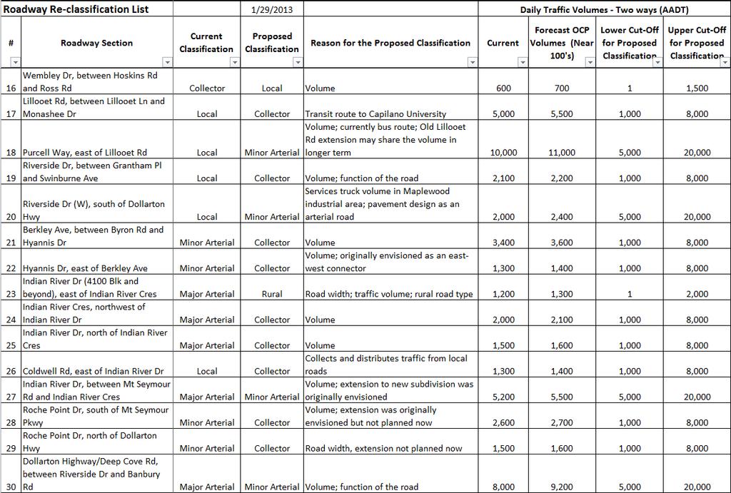
36 XII
122 Avenue: 107 Street to Fort Road
 : 107 Street to Fort Road November 24, 2015 4:30 8:00 p.m. Meeting Purpose Summarize project work completed to date Share results of public input from Phase 1 Share the draft concept plan and proposed
2.0 LANE WIDTHS GUIDELINE
 2.0 LANE WIDTHS GUIDELINE Road Engineering Design Guidelines Version 2.0.1 May 2018 City of Toronto, Transportation Services City of Toronto Page 0 Background In early 2014, Transportation Services initiated
Chapter 3 DESIGN SPECIFICATIONS
 Brampton PathWays Planning and Design Guidelines 27 Chapter 3 DESIGN SPECIFICATIONS 3.1 CLASS 1 MULTI-USE PATH Off-road multi-use trails are the backbone of the Brampton PathWays Network. They are typically
10.0 CURB EXTENSIONS GUIDELINE
 10.0 CURB EXTENSIONS GUIDELINE Road Engineering Design Guidelines Version 1.0 March 2017 City of Toronto, Transportation Services City of Toronto Page 0 Background In early 2014, Transportation Services
Classification Criteria
 SCHEDULE D TO RECOMMENDED OFFICIAL PLAN AMENDMENT NO. 40 SCHEDULE C-4 Road Criteria Criteria Traffic Service Objective Land Service/Access Typical Daily Traffic Volume Flow characteristics Travel Speed
Appendix A. Road Classification Review of Outstanding Issues and Proposed Classifications (All Wards) Staff Report Road Classification System
 Staff Report Road Classification System") Appendix A Road Classification Review of Outstanding Issues and Proposed Classifications (All Wards) Staff Report 2000 A.1 of A.10 A.2 of A.10 STAFF REPORT January 26, 2000 To: From: Works Committee Barry
Appendix A Road Classification Review of Outstanding Issues and Proposed Classifications (All Wards) Staff Report 2000 A.1 of A.10 A.2 of A.10 STAFF REPORT January 26, 2000 To: From: Works Committee Barry
NEIGHBOURHOOD TRAFFIC COMMITTEE POLICY AND PROCEDURE
 The City of Vaughan 2141 Major Mackenzie Drive Vaughan, Ontario Canada L6A 1T1 Tel (905) 832-2281 NEIGHBOURHOOD TRAFFIC COMMITTEE POLICY AND PROCEDURE REVISED JUNE 2010 APPLICABILITY The Neighbourhood
City of Wayzata Comprehensive Plan 2030 Transportation Chapter: Appendix A
 A1. Functional Classification Table A-1 illustrates the Metropolitan Council s detailed criteria established for the functional classification of roadways within the Twin Cities Metropolitan Area. Table
TRAFFIC STUDY GUIDELINES Clarksville Street Department
 TRAFFIC STUDY GUIDELINES Clarksville Street Department 9/1/2009 Introduction Traffic studies are used to help the city determine potential impacts to the operation of the surrounding roadway network. Two
CITY OF SASKATOON COUNCIL POLICY
 ORIGIN/AUTHORITY Clause 1, Report No. 1-1980 and Clause 4, Report No. 22-1990 of the Works and Utilities Committee; Clause 6, Report No. 17-2004 of the Planning and Operations Committee; and Clause D5,
Access Management Guidelines February 2013 THE CITY OF
 Access Management Guidelines February 2013 THE CITY OF Table of Contents Introduction 2 Review and Approval Process 5 Technical Guidelines 9... 10... 12 3. Separation Distance: Non-Signalized All-Turns
Roadway Classification Design Standards and Policies. Pueblo, Colorado November, 2004
 Roadway Classification Design Standards and Policies Pueblo, Colorado November, 2004 Table of Contents Page Chapter 1. General Provisions 1.1 Jurisdiction 3 1.2 Purpose and Intent 3 1.3 Modification 3
TRAFFIC CALMING GUIDE FOR TORONTO CITY OF TORONTO TRANSPORTATION SERVICES DIVISION
 TRAFFIC CALMING GUIDE FOR TORONTO CITY OF TORONTO TRANSPORTATION SERVICES DIVISION CITY OF TORONTO TRANSPORTATION SERVICES DIVISION 2016 TRAFFIC CALMING GUIDE FOR TORONTO TABLE OF CONTENTS Introduction
CITY OF WEST KELOWNA COUNCIL POLICY MANUAL
 CITY OF WEST KELOWNA COUNCIL POLICY MANUAL Page 1 of 7 DEPARTMENT: Engineering Services SUBJECT: Traffic Calming Policy (Revised June 6, 2017) Policy Statement: The provision of traffic calming measures
City of Elizabeth City Neighborhood Traffic Calming Policy and Guidelines
 City of Elizabeth City Neighborhood Traffic Calming Policy and Guidelines I. Purpose: The City of Elizabeth City is committed to ensure the overall safety and livability of residential neighborhoods. One
Transportation Policy Manual
 March 4, 2013 EXHIBIT 2 Metropolitan Transportation Planning Organization for the Gainesville Urbanized Area A Comprehensive Guide to Adopted Metropolitan Transportation Planning Organization for the
POLICY: TRAFFIC CALMING
 2006 MAY REFERENCE: COUNCIL APPROVED BY COUNCIL MAY 23, 2006 CITY OPERATIONS - NO. 608 POLICY: TRAFFIC CALMING A. All requests for traffic calming within the City shall be considered in accordance with
o n - m o t o r i z e d transportation is an overlooked element that can greatly enhance the overall quality of life for the community s residents.
 N o n - m o t o r i z e d transportation is an overlooked element that can greatly enhance the overall quality of life for the community s residents. 84 Transportation CHAPTER 11 INTRODUCTION Transportation
TOWN OF CHAPEL HILL POLICY AND PROCEDURES FOR TRAFFIC CALMING MEASURES
 TOWN OF CHAPEL HILL POLICY AND PROCEDURES FOR TRAFFIC CALMING MEASURES (Adopted by the Town Council on June 30, 2004) (Revised December 6, 2010) (Revised February 8, 2016) POLICY AND PROCEDURES FOR TRAFFIC
Appendix 3 Roadway and Bike/Ped Design Standards
 Appendix 3 Roadway and Bike/Ped Design Standards OTO Transportation Plan 2040 4/20/2017 Page A3-1 Adopted Standards The adopted OTO Design Standards and Major Thoroughfare Plan are contained herein.
102 Avenue Corridor Review
 February 26, 2015 102 Avenue Corridor Review Transportation Association of Canada Road Safety Engineering Award Submission for the City of Edmonton Introduction Transportation Association of Canada Road
West Dimond Blvd Upgrade Jodhpur Street to Sand Lake Road
 West Dimond Blvd Jodhpur St to Sand Lake CSS Transportation Project Summary Municipality of Anchorage Project # 05 005 Project Manager: John Smith, P.E. (MOA PM&E) Project Administrator: Julie Makela,
CITY MANUALS AND STANDARDS REVIEW
 GEORGETOWN SIDEWALK MASTER PLAN CITY MANUALS AND STANDARDS REVIEW RESOURCES AND STANDARDS As part of the Master Plan process, a review and evaluation of current City documents and policies relevant to
Chapter 2: Standards for Access, Non-Motorized, and Transit
 Standards for Access, Non-Motorized, and Transit Chapter 2: Standards for Access, Non-Motorized, and Transit The Washtenaw County Access Management Plan was developed based on the analysis of existing
Downey Road. Transportation Improvement Study
 Downey Road Transportation Improvement Study Workshop 2 Participant Handbook Workshop 1 May 18 and 19, 2016 Workshop 2 June 23 and 28, 2016 Prepared By: City of Guelph Paradigm Transportation Solutions
Coquitlam Cross-town Bike Route Improving Bicycle Facilities in a Mature Suburban Environment
 Coquitlam Cross-town Bike Route Improving Bicycle Facilities in a Mature Suburban Environment Sarah Rocchi, Vice-President, Projects, Opus International Consultants (Main Presenter) Catherine Mohoruk,
Exhibit 1 PLANNING COMMISSION AGENDA ITEM
 Exhibit 1 PLANNING COMMISSION AGENDA ITEM Project Name: Grand Junction Circulation Plan Grand Junction Complete Streets Policy Applicant: City of Grand Junction Representative: David Thornton Address:
APPENDIX 2 LAKESHORE ROAD TRANSPORTATION REVIEW STUDY EXECUTIVE SUMMARY
 APPENDIX 2 LAKESHORE ROAD TRANSPORTATION REVIEW STUDY EXECUTIVE SUMMARY Appendix 2 City of Mississauga Lakeshore Road FINAL REPORT Transportation Review Study December 2010 EXECUTIVE SUMMARY Study Purpose
Proposed Bridge Street East Bicycle Lanes Public Open House Thursday, April 27, 2017
 WELCOME Proposed Bridge Street East Bicycle Lanes Public Open House Thursday, April 27, 2017 Purpose of the Open House The purpose of this Open House is to gain public input on the bicycle lanes proposed
DRAFT - CITY OF MEDFORD TRANSPORTATION SYSTEM PLAN Roadway Cross-Sections
 Roadway Cross-Sections Medford s roadway cross-section standards apply to new and reconstructed roads. The crosssections take into consideration roadway function and operational characteristics, including
Road Alterations - Wellington Street East, Church Street, and Front Street Intersection
 REPORT FOR ACTION Road Alterations - Wellington Street, Church Street, and Front Street Intersection Date: November 1, 2016 To: Toronto and York Community Council From: Director, Public Realm Section,
Traffic Calming Policy
 Article I. Purpose and Goal. The purpose of this policy is to establish criteria and procedures the City will use to evaluate requests for, and if appropriate, implement traffic calming measures. Neighborhood
Geometric Design Tables
 Design Manual Chapter 5 - Roadway Design 5C - Geometric Design Criteria 5C-1 Geometric Design Tables A. General The following sections present two sets of design criteria tables - Preferred Roadway Elements
5.0 Roadway System Plan
 Southwest Boise Transportation Study Page 16 5.0 Roadway System Plan The Roadway System Plan outlines roadway improvements in the Initial Study Area. It forecasts future deficiencies on the arterial system,
Appendix T CCMP TRAIL TRAFFIC & TRANSPORTATION DESIGN STANDARD
 Appendix T CCMP 3.3.4 TRAIL TRAFFIC & TRANSPORTATION DESIGN STANDARD 3.3.4 Trail Traffic and Transportation Design Multi-use trails have certain design standards, which vary depending on the agency that
CITY OF OTTAWA ROADWAY MODIFICATION APPROVAL UNDER DELEGATED AUTHORITY
 RMA-2015-ATM-038 CITY OF OTTAWA ROADWAY MODIFICATION APPROVAL UNDER DELEGATED AUTHORITY DATE: April 22, 2015 SUBJECT Approval of Roadway Modifications Recommended through an Area Traffic Management Study
Chapter 7. Transportation. Transportation Road Network Plan Transit Cyclists Pedestrians Multi-Use and Equestrian Trails
 Chapter 7 Transportation Transportation Road Network Plan Transit Cyclists Pedestrians Multi-Use and Equestrian Trails 7.1 TRANSPORTATION BACKGROUND The District of Maple Ridge faces a number of unique
Prepared For: Shieldbay Developments Inc. c/o Matson, McConnell Ltd. 2430A Bloor Street West Toronto, Ontario M6S 1P9.
 Prepared For: Shieldbay Developments Inc. c/o Matson, McConnell Ltd. 2430A Bloor Street West Toronto, Ontario M6S 1P9 Prepared By: URS Canada Inc. 4 th Floor, 30 Leek Crescent Richmond Hill, Ontario L4B
INTRODUCTION THOROUGHFARE SYSTEM CLASSIFICATIONS
 INTRODUCTION The thoroughfare plan will assist public officials in the development of a specialized system for efficient and safe movement of vehicular traffic while minimizing potential conflicts with
Recommended Roadway Plan Section 2 - Land Development and Roadway Access
 Recommended Roadway Plan Section 2 - Land Development and Roadway Access SECTION 2 Land Development and Roadway Access 2.1 Land Use and Access Management The Federal Highway Administration (FHWA) defines
ARLINGTON COUNTY, VIRGINIA
 ARLINGTON COUNTY, VIRGINIA County Board Agenda Item Meeting of October 15, 2016 DATE: October 7, 2016 SUBJECT: Adoption of amendments to the Master Transportation Plan (MTP) to create a new Pedestrian
Clackamas County Comprehensive Plan
 ROADWAYS The County s road system permits the movement of goods and people between communities and regions, using any of a variety of modes of travel. Roads provide access to virtually all property. They
Document 2 - City of Ottawa Pedestrian Crossover (PXO) Program
 Program") 40 Document 2 - City of Ottawa Pedestrian Crossover (PXO) Program OVERVIEW The City of Ottawa Pedestrian Crossover (PXO) Program provides the basis for PXO implementation in Ottawa. The program s processes
40 Document 2 - City of Ottawa Pedestrian Crossover (PXO) Program OVERVIEW The City of Ottawa Pedestrian Crossover (PXO) Program provides the basis for PXO implementation in Ottawa. The program s processes
Policy Number: Effective: 07/11/14 Responsible Division: Planning Date: 07/11/2014 FUNCTIONAL CLASSIFICATION AMENDMENT POLICY
 Policy Number: 2014-025 Effective: 07/11/14 Responsible Division: Planning Date: 07/11/2014 FUNCTIONAL CLASSIFICATION AMENDMENT POLICY POLICY STATEMENT: The Northeast Ohio Areawide Coordinating Agency
Chapter 6 Transportation Plan
 Chapter 6 Transportation Plan Transportation Plan Introduction Chapter 6 Transportation Plan Transportation Plan Introduction This chapter describes the components of Arvada s transportation system, comprised
Complete Streets. Designing Streets for Everyone. Sarnia
 Complete Streets Designing Streets for Everyone Sarnia Complete Streets ~ Sarnia ~ 2018 Introduction Our City is made up of a network of streets that we use to go for a walk, cycle to work, drive to the
4. ENVIRONMENTAL IMPACT ANALYSIS 9. TRANSPORTATION AND TRAFFIC
 4. ENVIRONMENTAL IMPACT ANALYSIS 9. TRANSPORTATION AND TRAFFIC 4.9.1 INTRODUCTION The following section addresses the Proposed Project s impact on transportation and traffic based on the Traffic Study
This Chapter sets forth the minimum design, technical criteria and specifications to be used in the preparation of all roadway plans.
 4.1 GENERAL This Chapter sets forth the minimum design, technical criteria and specifications to be used in the preparation of all roadway plans. These Roadway Standards are for new construction and modification
Appendix O. Assessment of Bicycle Facility Alternatives
 Appendix O Assessment of Bicycle Facility Alternatives FINAL ASSESSMENT OF CROSS-SECTION ELEMENTS Lakeshore Road, from Mississaga Street to Dorval Drive Town of Oakville Submitted to: Town of Oakville
City of Memphis On-Street Parking Modification Guidelines
 City of Memphis Effective Date: December 1, 2013 Bicycle/Pedestrian Program 125 N. Main Street Memphis, TN 38103 (901) 576-6710 www.bikepedmemphis.com City of Memphis Executive Summary It is current practice
TRAFFIC IMPACT STUDY CRITERIA
 Chapter 6 - TRAFFIC IMPACT STUDY CRITERIA 6.1 GENERAL PROVISIONS 6.1.1. Purpose: The purpose of this document is to outline a standard format for preparing a traffic impact study in the City of Steamboat
DEPARTMENT OF ENVIRONMENTAL SERVICES. North Harrison Street (Lee Highway to Little Falls Road) Comparative Analysis. Prepared for:
 Comparative Analysis. Prepared for:") DEPARTMENT OF ENVIRONMENTAL SERVICES North Harrison Street (Lee Highway to Little Falls Road) Comparative Analysis Prepared for: Arlington County Department of Environmental Services 2100 Clarendon Boulevard,
DEPARTMENT OF ENVIRONMENTAL SERVICES North Harrison Street (Lee Highway to Little Falls Road) Comparative Analysis Prepared for: Arlington County Department of Environmental Services 2100 Clarendon Boulevard,
COUNTY ROAD 22 HORSESHOE VALLEY ROAD. Municipal Class Environmental Assessment. simcoe.ca
 OCTOBER 2014 Municipal Class Environmental Assessment COUNTY ROAD 22 HORSESHOE VALLEY ROAD Project A Truck Climbing Lanes Project B Intersection Improvements simcoe.ca CORPORATE COMMUNICATIONS DEPARTMENT
Minor Amendments to the Street and Traffic By-law 2849 and Skateboards in Protected Bike Lanes
 ADMINISTRATIVE REPORT Report Date: October 31, 2017 Contact: Lon LaClaire Contact No.: 604.873.7336 RTS No.: 12241 VanRIMS No.: 08-2000-20 Meeting Date: November 15, 2017 TO: FROM: SUBJECT: Standing Committee
Traffic Impact Study. Westlake Elementary School Westlake, Ohio. TMS Engineers, Inc. June 5, 2017
 TMS Engineers, Inc. Traffic Impact Study Westlake Elementary School Westlake, Ohio June 5, 2017 Prepared for: Westlake City Schools - Board of Education 27200 Hilliard Boulevard Westlake, OH 44145 TRAFFIC
As the Toronto Transit Commission (TTC) operates a transit service on Avenue Road, City Council approval of this report is required.
 operates a transit service on Avenue Road, City Council approval of this report is required.") REPORT FOR ACTION Corridor Safety Review - Avenue Road Date: September 27, 2017 To: Toronto and East York Community Council From: Acting Director, Transportation Services, Toronto and East York District
REPORT FOR ACTION Corridor Safety Review - Avenue Road Date: September 27, 2017 To: Toronto and East York Community Council From: Acting Director, Transportation Services, Toronto and East York District
Edgemont Village Traffic and Parking Technical Report January 2014
 Edgemont Village Traffic and Parking Technical Report January 2014 In the fall of 2013, the District of North Vancouver engaged consultants to assess existing intersection and parking conditions in Edgemont
Driveway Design Criteria
 Design Manual Chapter 5 - Roadway Design 5L - Access Management 5L-4 Driveway Design Criteria A. General For efficient and safe operations, access drives and minor public street intersections can be improved
Sixth Line Development - Transit Facilities Plan
 Memorandum Date: November 13, 2012 To: From: c.c. Subject: Rob Freeman (Freeman Planning) Kevin Phillips Sixth Line Development - Transit Facilities Plan 33016631 This memo was prepared to review the transit
Chapter 6: Transportation
 Chapter 6: Transportation I. INTRODUCTION The purpose of the Transportation Plan element of the Comprehensive Plan is to provide guidance to the City of North Mankato, as well as existing and future landowners
SECTION 1 - TRAFFIC PLANNING
 SECTION 1 - TRAFFIC PLANNING 1.1 TRAFFIC OPERATIONS 1.1.1 Roadway Functional Classification The Multnomah County Comprehensive Framework Plan s Policy 34: Trafficways and the Functional Classification
Town of Clarkstown Traffic Calming Program. Table of Contents
 Town of Clarkstown Traffic Calming Program Table of Contents I. INTRODUCTION a. Purpose & Intent b. Key to Successful Projects c. What is Traffic Calming? II. Definitions III. Street Classification IV.
Pedestrian Crosswalk Audit
 1200, Scotia Place, Tower 1 10060 Jasper Avenue Edmonton, Alberta T5J 3R8 edmonton.ca/auditor Pedestrian Crosswalk Audit June 19, 2017 The conducted this project in accordance with the International Standards
9.1 FUNCTIONAL HIGHWAY SYSTEMS IN URBANIZED AREAS Principal Arterial Interstate Principal Arterial Non-Interstate
 Greater Bozeman Area Transportation Plan (2007 Update) Chapter 9: Recommended Major Street Network & Roadway Typical Sections 9.1 FUNCTIONAL HIGHWAY SYSTEMS IN URBANIZED AREAS The discussion in this Chapter
5. RUNNINGWAY GUIDELINES
 5. RUNNINGWAY GUIDELINES These guidelines should be considered collectively when making runningway decisions. A runningway is the linear component of the transit system that forms the right-of-way reserved
SANTA CLARA COUNTYWIDE BICYCLE PLAN August 2008
 SANTA CLARA COUNTYWIDE BICYCLE PLAN August 2008 To assist VTA and Member Agencies in the planning, development and programming of bicycle improvements in Santa Clara County. Vision Statement To establish,
Services Department A September 18, 2006 Region of Durham Recommended Arterial Corridor All Wards Guidelines Study
 Report To: From: Subject: Development Services Committee Commissioner, Development Item: Date of Report: DS-06-55 September 13, 2006 File: Date of Meeting: Services Department A-2261-0002 September 18,
Harbord Street and Hoskin Avenue Bicycle Lane Upgrades
 STAFF REPORT ACTION REQUIRED and Bicycle Lane Upgrades Date: April 22, 2014 To: From: Wards: Reference Number: Public Works and Infrastructure Committee General Manager, Transportation Services 19 and
Chapter 5 FUNCTIONAL CLASSIFICATION
 Chapter 5 FUNCTIONAL CLASSIFICATION Functional classification is a system by which streets and roadways may be distinguished by types according to their function within the entire transportation network.
Access requests to County streets and roadways are processed through one of the following methods:
 13.1 GENERAL APPLICATION PROCESS Access requests to County streets and roadways are processed through one of the following methods: A. Planned Developments may set general locations for access points.
CITY OF SAINT JOHN TRAFFIC CALMING POLICY
 CITY OF SAINT JOHN TRAFFIC CALMING POLICY VERSION: 1.0 April 10, 2012 Pedestrians, Cyclists and Motorists Sharing Street Spaces CONTENTS INTRODUCTION... 3 POLICY GOAL... 3 POLICY OBJECTIVES... 3 GUIDING
STATEMENT of POLICY and PROCEDURE
 SCHEDULE B to BY-LAW NO. 96-2013 STATEMENT of POLICY and PROCEDURE No. Responsibility: Roads Date: October 21, 2013 Policy: Road Design Standards Revised: Approved by: By-law No. 96-2013 Pages: 6 Purpose:
This chapter describes the proposed circulation system and transportation alternatives associated with
 5.0 Circulation 5.1 OVERVIEW This chapter describes the proposed circulation system and transportation alternatives associated with West Landing, and summarize the information contained in the Existing
Multimodal Through Corridors and Placemaking Corridors
 68 Multimodal Through Corridors and Placemaking Corridors Corridors have different functions in a region. Some corridors are used to get smoothly and rapidly through a region or to get quickly to major
ADA Transition Plan. City of Gainesville FY19-FY28. Date: November 5, Prepared by: City Of Gainesville Department of Mobility
 ADA Transition Plan FY19-FY28 Date: November 5, 2018 Prepared by: City Of Gainesville Department of Mobility 1.0 INTRODUCTION 1.1 BACKGROUND The federal statute known as the Americans with Disabilities
MUTCD Part 6G: Type of Temporary Traffic Control Zone Activities
 MUTCD Part 6G: Type of Temporary Traffic Control Zone Activities 6G.01 Typical Applications Each temporary traffic control (TTC) zone is different. Many variables, such as location of work, highway type,
M-58 HIGHWAY ACCESS MANAGEMENT STUDY Mullen Road to Bel-Ray Boulevard. Prepared for CITY OF BELTON. May 2016
 M-58 HIGHWAY ACCESS MANAGEMENT STUDY Prepared for CITY OF BELTON By May 2016 Introduction Missouri State Highway 58 (M-58 Highway) is a major commercial corridor in the City of Belton. As development has
CITY OF ROCK HILL, SOUTH CAROLINA. Neighborhood Traffic Calming Program A Policy for Use of Traffic Calming on Local (Residential) Streets
 Streets") CITY OF ROCK HILL, SOUTH CAROLINA Neighborhood Traffic Calming Program A Policy for Use of Traffic Calming on Local (Residential) Streets I. Statement of Purpose: This program provides a process and a
CITY OF ROCK HILL, SOUTH CAROLINA Neighborhood Traffic Calming Program A Policy for Use of Traffic Calming on Local (Residential) Streets I. Statement of Purpose: This program provides a process and a
Southside Road. Prepared for: City of St. John s Police & Traffic Committee. Prepared by: City of St. John s Traffic Division
 Southside Road Prepared for: City of St. John s Police & Traffic Committee Prepared by: City of St. John s Traffic Division January 2007 Southside Road - Traffic Report Page 1 of 9 BACKGROUND: th At the
1.3.4 CHARACTERISTICS OF CLASSIFICATIONS
 Geometric Design Guide for Canadian Roads 1.3.4 CHARACTERISTICS OF CLASSIFICATIONS The principal characteristics of each of the six groups of road classifications are described by the following figure
Active Transportation Infrastructure Investment A Business Case
 Active Transportation Infrastructure Investment A Business Case In 2016, the Real Estate Foundation awarded the Capital Regional District a $50,000 grant for Shifting Gears: Land Use Change through Active
Zlatko Krstulich, P.Eng. City of O9awa
 Zlatko Krstulich, P.Eng. City of O9awa 1. Introduction to the Ontario Traffic Manual Series 2. What is OTM Book 18: Bicycle Facilities? 3. Study / Committee Team Members 4. Brief overview of the content
CITY OF COCONUT CREEK IMPLEMENTATION GUIDELINES FOR TRAFFIC CALMING
 CITY OF COCONUT CREEK IMPLEMENTATION GUIDELINES FOR TRAFFIC CALMING I. Introduction: The City of Coconut Creek recognizes that the conditions of residential streets can greatly affect neighborhood livability;
City of Toronto Road Classification System. Summary Document
 City of Toronto Road Classification System Summary Document City of Toronto Road Classification System Summary Document City of Toronto Copyright 2013 Published August 2013 CONTACT INFORMATION For information
MUNICIPALITY OF ANCHORAGE Traffic Department MEMORANDUM
 MUNICIPALITY OF ANCHORAGE DATE: MEMORANDUM TO: FROM: SUBJECT: Anchorage Contractors, Builders, Designers, and Land Owners Robert E. Kniefel, P.E., Municipal Traffic Engineer Municipal Driveway Standards
City of White Rock. Strategic Transportation Plan. May 16, 2005
 City of White Rock Strategic Transportation Plan May 16, 2005 1 Outline Scope of Plan & Approach Council input and direction Key issues based on existing conditions Range of strategies to consider? Next
County of Greenville South Carolina. Traffic Calming Program Neighborhood Traffic Education Program and Speed Hump Program
 County of Greenville South Carolina Traffic Calming Program Neighborhood Traffic Education Program and Speed Hump Program (rev) August 2008 I. PURPOSE The potential negative impacts from vehicular traffic
Confirmation of Levels of Service for Winter Maintenance of Bikeways, Windrow Opening, Sidewalks and AODA Compliance
 STAFF REPORT ACTION REQUIRED Confirmation of Levels of Service for Winter Maintenance of Bikeways, Windrow Opening, Sidewalks and AODA Compliance Date: March 17, 2014 To: From: Wards: Reference Number:
In station areas, new pedestrian links can increase network connectivity and provide direct access to stations.
 The Last Mile Planning for Pedestrians Planning around stations will put pedestrians first. Making walking to stations safe and easy is important; walking will be a part of every rapid transit Accessible
REPORT. Engineering and Construction Department
 REPORT COMMUNITY SERVICES COMMITTEE MEETING DATE: JUNE 11, 2013 FROM: Engineering and Construction Department DATE: May 24, 2013 SUBJECT: Great Lakes Boulevard Mini Roundabout LOCATION: Great Lakes Boulevard
Traffic Control Signals - Cosburn Avenue and Cedarvale Avenue
 REPORT FOR ACTION Traffic Control Signals - Cosburn Avenue and Cedarvale Avenue Date: April 24, 2017 To: Toronto and East York Community Council From: Acting Director, Transportation Services, Toronto
Lynn Valley Town Centre Transportation Study 2013
 Lynn Valley Town Centre Transportation Study 2013 In 2013, Urban Systems consultants completed a comprehensive Transportation Study for Lynn Valley Town Centre. The study assessed worst case scenario of
WYDOT DESIGN GUIDES. Guide for. NHS Arterial (Non-Interstate)
") WYDOT DESIGN GUIDES Guide for NHS Arterial (Non-Interstate) 2014 GUIDE FOR NATIONAL HIGHWAY SYSTEM (NHS) HIGHWAYS (NHS ARTERIALS, Non-Interstate) PRESERVATION REHABILITATION RECONSTRUCTION INTRODUCTION
WYDOT DESIGN GUIDES Guide for NHS Arterial (Non-Interstate) 2014 GUIDE FOR NATIONAL HIGHWAY SYSTEM (NHS) HIGHWAYS (NHS ARTERIALS, Non-Interstate) PRESERVATION REHABILITATION RECONSTRUCTION INTRODUCTION
WYDOT DESIGN GUIDES. Guide for. Non-NHS State Highways
 WYDOT DESIGN GUIDES Guide for Non-NHS State Highways 2014 GUIDE FOR Non-NATIONAL HIGHWAY SYSTEM (Non-NHS) STATE HIGHWAYS PRESERVATION REHABILITATION RECONSTRUCTION INTRODUCTION This Guide is directed to
Implementing Complete Streets in Ottawa. Project Delivery Process and Tools Complete Streets Forum 2015 October 1, 2015
 Implementing Complete Streets in Ottawa October 1, 2015 The Essentials Complete Streets Implementation Framework will become part of the routine delivery of City transportation projects Approach uses every
Transportation Impacts: Toronto York Spadina Subway Extension
 STAFF REPORT ACTION REQUIRED Transportation Impacts: Toronto York Spadina Subway Extension Date: June 6, 2011 To: From: Wards: Reference Number: North York Community Council Director, Transportation Services
CONTEXT SENSITIVE STREETS STANDARDS COMMITTEE
 CONTEXT SENSITIVE STREETS STANDARDS COMMITTEE February 23, 2015 Prepared by: Denise Chaplick, AICP City Jacksonville Bicycle and Pedestrian Coordinator Source: NCDOT Complete Streets Planning and Design
TRAFFIC CALMING POLICY & PROCEDURES
 TRAFFIC CALMING POLICY & PROCEDURES AS ADOPTED BY MONTCLAIR TOWNSHIP COUNCIL AUGUST 4, 2009 TABLE OF CONTENTS 1. INTRODUCTION... 2 Purpose... 2 Traffic Calming Definition... 2 Statement Of Township Council
STANLEY STREET December 19, 2017
 STANLEY STREET December 19, 2017 Welcome Mike Wiza, Mayor Scott Beduhn, Director of Public Works Agenda 1. Introduction 2. Existing Roadway Conditions 3. Current Alternative Improvements 4. Summary of
Report. Typical Sections. City of Middleton, WI
 Report Typical Sections City of Middleton, WI December 2006 Report for City of Middleton, Wisconsin Typical Sections repared by: Traffic Associates LLC and STRAND ASSOCIATES, INC. 910 West Wingra Drive