State Street Corridor Study Final Report. Table of Contents
|
|
|
- Kory Morton
- 5 years ago
- Views:
Transcription


1
2 Table of Contents Executive Summary... 1 Introduction... 4 Problem Statement... 4 Study Purpose... 4 Purpose of this Document... 4 Corridor Characteristics... 6 Existing and Future... 7 Study Approach... 9 Participants Improvement Options and Future Scenarios Improvement Options Future Scenarios Corridor Urbanization Transit Scenario Conventional Scenario High Capacity Scenario Public Involvement Results Public Involvement Process Public Meeting 1 Results Public Meeting 2 Results Public Meeting 3 Results Preferred Scenario and Implementation Strategy Scenario Evaluation Preferred Scenario Roadway Requirements Transit Operation Commercial Development Nodes Implementation Strategy Roadway Land Use/Urban Form Transit Recommendations Supporting Data Volume I: Existing and Future Conditions (essentially Tech Memo A)... Supporting Data Volume II: Public Involvement Process and Results... Supporting Data Volume III: Scenario Development and Analysis... Meyer, Mohaddes Associates Table of Contents i
3 List of Figures Figure 1 State Street Corridor Study Project Area Map... 5 Figure 2 State Street Corridor Study Existing and Future Average Daily Traffic Volumes... 8 Figure 3 State Street Corridor Study Approach Figure 4 Extent of Corridor Urbanization Figure 5 Transit Scenario HOV in Curb Lane Figure 6 Transit Scenario North Side Transitway Figure 7 Veterans Memorial Parkway Node Concept Figure 8 Collister Node Concept Figure 9 Conventional Scenario Figure 10 Veterans Memorial Parkway Interchange Concept Figure 11 Glenwood/Gary Interchange Figure 12 High Capacity Scenario Figure 13 High Capacity Scenario Collister Interchange Concept Figure 14 Preferred Scenario Figure 15 Flowchart for Implementation Meyer, Mohaddes Associates List of Figures ii
4 List of Tables Table 1 Transit Scenario At A Glance...3 Table 2 Intersection Delay and LOS...7 Table 3 Improvement Strategies Table 4 Summary of Three Public Meetings Table 5 Level of Support for all of the 38 improvement options, ranked by strongest support as provided by attendees at the second State Street Corridor Study public meeting Table 6 Level of like or dislike of the scenario elements at the third State Street Corridor public meeting Table 7 Summary of comments received from the public s review of the Final Report Initial Draft Table PM Peak Hour Level of Service Table 9 Scenario Evaluation Results Table 10 Land Use/Urban Form Work Program for Individual Nodes Table Year Roadway Improvements Meyer, Mohaddes Associates List of Tables iii
5 EXECUTIVE SUMMARY State Street is a major gateway to the City of Boise that provides the only complete east-west connection north of the Boise River. It serves as an essential arterial carrying commuter, neighborhood, general business, leisure/ recreational, and commercial traffic to and from downtown Boise. The thriving Treasure Valley economy, successful downtown Boise businesses, tremendous residential growth to the west, and limited public transportation options have left State Street with significant traffic delays during peak times, higher than average accident rates, and projected traffic volumes that will grid-lock the corridor in the future. The acknowledgement of these issues led the Ada County Highway District (ACHD) and the City of Boise to commission the development of a strategic plan for the State Street Corridor from 23 rd Street to State Highway 55. This report documents the results of this study that include the near-term improvements necessary, the vision for how State Street should evolve over the next 20 years, and an implementation plan to help the multi-jurisdictional agencies responsible for this area make the vision a reality. A comprehensive transportation planning study was conducted to evaluate the deficiencies and develop solutions. Existing and future conditions analysis identified corridor deficiencies in the areas of traffic operations, public transportation and alternate modes (including pedestrian and bicycle), corridor features, and geometric configurations. Potential improvement options (38 separate) were developed and matched to the deficiencies. Further analysis created a list of near-term improvements required and a set of three long-term scenarios which represented different possible visions for the corridor. Finally, a preferred scenario was selected and a strategy was formed to identify the necessary steps toward implementation. A multi-jurisdictional team worked closely throughout the study. It was evident early on in the study process that in order to implement change in the State Street corridor a multijurisdictional team would be required. The agencies that participated in the study included ACHD, Boise City, Garden City, Community Planning Association of Southwest Idaho (COMPASS), Idaho Transportation Department (ITD), and ValleyRide. Staff members from the agencies, a citizen representative and consultants formed a collaborative and productive team interested in moving forward with the recommendations of this strategic plan. An extensive public involvement process supported the study results and outcomes. Nearly 45% of the total study budget was dedicated to the preparation and conduct of the public involvement process. That process included stakeholder meetings, special gatherings of business and neighborhood representatives, three large public meetings, workshops and presentations to Commissions and City Councils, and outreach to interested parties. A successful effort was made to balance the needs of the neighborhoods, businesses, and commuters. The public involvement process provided invaluable information to the Study Team and influenced the results and outcome of the State Street Corridor Study. Additionally, the public commended the process and efforts of the team, fostering an increased level of trust and improved relations for future projects. Near-term (1-10 years) improvements are identified for implementation. The analysis conducted as part of the State Street Corridor Study determined that there are numerous, lower-cost improvements that can be made in the near-term to improve the operation and look of State Street. These improvements are categorized into: traffic operation, public transportation, pedestrian/bicycle, and land use/other. Analysis showed that the implementation of these near-term improvements would be sufficient to accommodate future traffic volume growth over the next 10 years while essentially maintaining the existing level of traffic delay. After that, larger more expensive solutions would need to be implemented. Meyer, Mohaddes Associates Executive Summary 1
6 Three long-term scenarios are presented and evaluated as possible future visions. They include transit, conventional, and high capacity scenarios as follows: The Transit Scenario expands on the near-term improvements and provides for an additional dedicated lane in each direction to accommodate a rapid bus approach (10-minute headways during peak travel times). This would require a 7-lane roadway cross section with the corresponding right-of-way required. Additionally, this scenario recommends that the commercial development be reorganized into nodes at specific locations in the corridor. These commercial nodes would help to foster the use of public transportation and provide for more concentrated, useable services by the neighboring residents. The Conventional Scenario provides for two additional lanes of vehicle travel and therefore also requires a 7-lane cross section with the corresponding right-of-way required. The current commercial development patterns would continue to occur with no land use changes. Major intersections would require extensive changes with overpasses and other large treatments to accommodate the future traffic volumes. The High Capacity Scenario is the only one that does not require extensive right-of-way acquisition. Instead, it includes a three-lane elevated structure down the middle of State Street. These lanes would include one lane in each direction for mixed traffic and a reversible middle lane available for transit or High Occupancy Vehicles (HOVs). The elevated section would begin at 30 th street (east end) and continue west to Glenwood Boulevard. Interchanges would be required at key locations. The Transit Scenario is preferred by the Study Team and the public, alike. The preferred scenario for State Street is the Transit Scenario it incorporates a multi-modal vision for the corridor that includes a progressively increasing level of transit service and is consistent with the regional plans for the corridor. This scenario was the result of the Study Team s analysis and was the most supported by the public. It also requires a change in development patterns (concentrated nodes ) to take advantage of the enhanced transit. It provides for an expanded roadway to accommodate both transit and increases in regional traffic. A summary of the Transit Scenario is provided in Table 1. To make this a reality, the multi-agency study team will need to continue to work together to address all the challenges yet to be faced. An implementation strategy is developed to assist toward beginning the next steps. The implementation of the Transit Scenario will require three parallel strategies involving aspects of the: roadway (ACHD), land use/urban form (cities), and transit (ValleyRide). The success of this recommended strategy requires the alignment of the agency actions into a coordinated framework. The affected agencies are committed to the success of the transit scenario. However, they recognize that several near-term elements of this scenario need to be achieved in order to fully realize the benefits of this new concept. The progress of these achievements will be monitored carefully to determine the future timing and scale of any large infrastructure investments by the agencies. Study recommendations focus on implementation of the State Street Corridor Study results and outcomes. The Study Team recommends the following actions begin immediately: 1. Adopt the Transit Scenario as State Street s future vision. 2. Form a joint working group to implement the vision that includes staff from ACHD, Boise City, Garden City, City of Eagle, and ValleyRide. 3. Focus implementation on the redevelopment nodes begin with Veterans Memorial Parkway and Collister Drive. 4. Pursue an incremental approach to roadway improvements. This includes monitoring performance of the corridor for enhanced mobility, transit use, and change in urban form. 5. Accelerate transit planning for State Street by incorporating these results into the regional transit plan. Meyer, Mohaddes Associates Executive Summary 2
7 Table 1. Transit Scenario At A Glance Description: The preferred Transit Scenario incorporates a multi-modal vision for the State Street Corridor one that includes an increased frequency and coverage of transit service, a change in development patterns to take advantage of enhanced transit, and an expanded roadway to accommodate both transit and future increases in regional traffic. Transit dedicated lanes on both sides of the street are required to facilitate the level of transit service envisioned, making the roadway a total of seven lanes. The Transit Scenario was chosen because it demonstrated a higher overall level of meeting the objectives of the strategic plan and it provided the most flexibility for meeting future mobility needs. The estimated roadway costs for this scenario are $57 million. These costs exclude redevelopment and additional transit vehicles and operations costs. Public Input: Input from the public meetings indicated strong support for enhanced transit service. The public also supported commercial redevelopment at nodes and the notion of dedicated lanes for the high level of transit envisioned in this scenario. The public also expressed concern that people will not use the transit even if it is provided. Of the three scenarios presented at the final meeting, the Transit Scenario ranked the highest in the scorings, on average. Cross Section: Primary Elements: Rapid Bus: Bus Rapid Transit (BRT) at 10-minute headways with stops limited to ½ mile, special shelters and traffic signal priority Commercial Node Development: Concentrate retail at crossroads to provide opportunities to introduce higher intensity residential and commercial/office. Nodes are recommended at 28th, 33rd, Veteran s Memorial Parkway/36th, Collister, and Glenwood/Gary. Land Use Requirements: Nodes in the eastern half of the corridor would be mixed-use with a residential emphasis, while nodes to the west would be mixed-use with a commercial focus. Other Features: Landscaped median and bike lanes throughout, continuous sidewalks separated from the street by planting strips, ITS technology enhancements Implementation Strategy: Recommended approach is for ACHD, the City of Boise, Garden City, the City of Eagle and ValleyRide to work jointly on roadway, redevelopment and transit improvements, focusing first on the nodes at Veterans Memorial Parkway and Collister Road. Meyer, Mohaddes Associates Executive Summary 3
8 INTRODUCTION The Ada County Highway District (ACHD) and the City of Boise commissioned a study to develop a strategic plan for the State Street Corridor from 23 rd Street to State Highway 55 (6.4 miles). A map of the study area (Figure 1) is provided on the next page. This report documents the results of this study including the near-term improvements necessary, the vision for how State Street should evolve over the next 20 years, and elements of an implementation plan to help the multijurisdictional agencies responsible for this area make the vision a reality. PROBLEM STATEMENT State Street is located on the north side of the Treasure Valley and serves as an essential east-west arterial carrying commuter, neighborhood, general business, leisure/ recreational, and commercial traffic to and from downtown Boise. As a connection to northern and western neighboring communities that include Emmett, Horseshoe Bend, Eagle, Star and Middleton, it represents a major gateway to the City of Boise. No other major arterial exists north of the Boise River that provides this complete east-west connection. The thriving Treasure Valley economy, successful downtown Boise businesses, tremendous residential growth to the west, and limited public transportation options have left State Street with significant traffic delays during peak times, higher than average accident rates, and projected traffic volumes that will grid-lock the corridor. These issues led to a growing need for a long-term transportation and operational strategy to guide implementation of future improvements. vision. The study required the active participation of the responsible land use and traffic management agencies and input from the public that travels, provides and/or uses the services offered in the corridor. PURPOSE OF THIS DOCUMENT The purpose of this document is to provide the reader with a complete understanding of the results of the study, and the approaches and analysis used to arrive at those results. The contains one main body which concisely documents the study approaches and results, and three supporting data volumes containing the analyses and evaluations in a greater level of detail. Please use the following to find the information contained in this report that is most important to you. Report Chapter and Supporting Volumes Introduction Improvement Options and Future Scenarios Public Involvement Results Preferred Scenario and Implementation Strategy Recommendations Supporting Data Volumes I, II and III Contents Corridor Characteristics, Existing/Future Conditions, Study Approach, Participants Improvement Options, Future Scenarios Public Involvement Process, Results from Meetings 1, 2, and 3 Scenario Evaluation, Recommended Scenario, Implementation Strategy Specific Recommendations (I) Existing and Future Conditions; (II) Public Involvement Process and Results; (III) Scenario Development and Analysis STUDY PURPOSE The purpose of the State Street Corridor Study was to develop a strategic plan for this essential east-west corridor that would create a new future vision for State Street and define the nearterm improvements and future steps necessary to achieve that Meyer, Mohaddes Associates Introduction 4

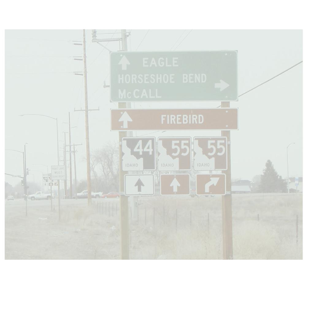
9 Figure 1. State Street Corridor Study Project Area Map Meyer, Mohaddes Associates Introduction 5
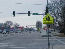
10 CORRIDOR CHARACTERISTICS The State Street Corridor, between the study boundaries of 23 rd Street and Highway 55, includes residences, schools, ITD headquarters, small office complexes, general businesses, retail stores, churches, and undeveloped land. It is a multi-use facility that functions as a primary transportation corridor for vehicles, transit, cyclists and pedestrians. State Street serves as a gateway to Boise and the regional connection to north Idaho. The street presents an image of the city with visually stimulating views of the Boise Foothills. Seven nodes have been identified along the corridor that serve as centers of activity and connections to the surrounding neighborhoods. Proceeding east on State Street, development spreads over the 4-mile entrance to Boise with a variety of architectural styles, numerous signs, and overhead utility lines presenting a visually chaotic image. The predominant land uses along State Street are commercial, office, public, and residential. The corridor is substantially built-up on the east end with large portions of vacant land on the west. Newer neighborhoods predominate the western segments of State Street. Many homes west of 36 th Street have large lots, gardens, and horse pastures. The zoning designations along the corridor encourage redevelopment of much of the corridor toward commercial centers and medium and high-density housing. The development of more intensive uses along State Street reflects higher land values and will continue to displace single-family residential uses along the street frontage. Design review procedures have been established by the City of Boise for new development fronting State Street. Design elements in Boise include a 20-foot landscaped setback for a parking area or building. ValleyRide operates Route 16 with one-hour headways along State Street to provide regular daily service and reversecommute service during peak periods on weekdays. Routes 1 and 2 provide directional service to State Street on Saturdays with 45-minute headways. Major pedestrian and bicycle investments have been made in the corridor to provide a multi-use path along the Boise River that connects from Glenwood Boulevard to the central business district (CBD). Following a northwest alignment, the Boise Greenbelt provides a paved path parallel to State Street. The path follows the north side of the river west to Plantation River Street, where it crosses the river and follows along the southern bank until it temporarily ends west of Glenwood Street. Future plans will extend the greenbelt westward to Eagle Island beyond the City of Eagle. Additionally, State Street is designated a bike lane and mixeduse route from 36 th Street to Gary Lane. State Street provides pedestrian connections to shopping centers, businesses, parks, schools, churches and neighborhoods along the corridor. Pedestrian facilities along State Street are limited to attached sidewalks along various portions of the corridor and numerous gaps are present in the western half of the corridor. A number of large grassy and treed areas help shape State Street. These include the Idaho Transportation Department campus, Veterans Park with its numerous evergreen trees, Lowell School with over a block of tree-lined playground, and a row of Maple trees along Plantation Golf Course. Often large cottonwood trees are visible from the street and along cross streets such as Willow Lane. Canals provide a natural feature to the roadway and a connection to local irrigation and agriculture. They include the Farmers Union Canal, which flows along the south side of the street from Willow Lane to Collister Drive. Other waterways crossing State Street includes Crane Creek Flume, Stuart Gulch, Boise Valley Canal, and Little Union Canal. The waterways provide both an aesthetic opportunity and a challenge to cross and blend into new development. Meyer, Mohaddes Associates Introduction 6
11 EXISTING AND FUTURE CONDITIONS The existing and future conditions of the State Street Study Corridor are documented in detail in the Supporting Data Volume I. The information presented here is meant to be a summary that focuses on the deficiencies derived from the existing and future condition analyses. They are as follows: Traffic Volumes are projected to significantly increase in the next 20 years. Figure 2 illustrates the existing, 2010 and 2025 average daily traffic volumes for selected locations within the corridor. Traffic volumes on State Street have increased from around 30,000 ADT to 37,000 ADT (over 23%) in the last 4 years. Traffic growth is expected to increase more than 50% in the next 20 years with volumes exceeding 55,000 ADT. This increase in traffic will exceed corridor and intersection capacity and create operational bottlenecks, as well as increased safety concerns. Intersection operations will continue to degrade as traffic volumes increase. Table 2, to the right, displays the intersection average delay and level of service for 2002 and expected in 2025 during pm peak travel periods. The data illustrates that as the traffic volumes increase in the corridor, the intersections will quickly breakdown and become significant bottlenecks severely impeding traffic flow. The existing conditions analysis shows that peak period intersection operations at the Glenwood/Gary Lane and 26th/27th Street locations are currently operating in saturated conditions and that the Veteran s Memorial Parkway intersection is experiencing near breakdown conditions during the PM peak period. Further breakdown and deficiencies would be expected to occur by the year Higher volumes along State Street would worsen conditions by causing more delay and lowering levels of service if modifications to the roadway are not made. As saturation is reached and thresholds are exceeded, roadway problems compound when improvements are not made. The existing problem areas (Glenwood/Gary Lane, Veteran s Memorial Parkway, and 26th/27th Street) would deteriorate further as volumes increase along the State Street corridor. By 2025, the Highway 55, Horseshoe Bend, Wal- Mart, Pierce Park, Collister Drive, 32nd Street, and 28th Street intersections would also reach saturation during one or both peak periods. Table 2. Intersection Delay and LOS PM Peak Hour Intersection Avg Delay/(Level-of-Service) Intersection Hwy (C) 232 (F) Horseshoe Bend 15 (B) 98 (F) Glenwood/Gary 52 (D) 128 (F) Pierce Park 18 (B) 119 (F) Collister 16 (B) 82 (F) VMP/36th 57 (E) 233 (F) 28th 36 (D) >250 (F) 26th/27th 90 (F) 146 (F) 23rd 4 (A) 22 (C) Crash rates are currently higher than average and are expected to grow as traffic volumes increase. Crash records for the project were obtained from the Idaho Transportation Department (ITD) Safety Department. There were 192, 181, and 188 crashes in the State Street study area in 1999, 2000, and 2001, respectively. Although traffic volumes have increased over the three-year analysis period, crashes remain essentially constant. There are significant numbers of access-related crashes, rear-end crashes, headon crashes, and congestion-related crashes at intersections in the corridor. The improvement options and scenarios recommended in the corridor address the safety concerns demonstrated by these numbers. Meyer, Mohaddes Associates Introduction 7

12 Figure 2. State Street Corridor Study Existing and Future Average Daily Traffic Volumes Meyer, Mohaddes Associates Introduction 8
13 Connection spacing and driveway densities are too high for a major arterial. The segments of State Street near Glenwood, Pierce Park, Plantation River, Collister, Willow, Veterans Memorial, 32 nd, 33 rd, and 28 th Streets have numerous driveway connections that are at or above 45 connections per mile, which is an indicator of increased crash potential and decreased corridor capacity. Several of the study improvement options included in all long-term scenarios incorporated consolidation of driveways to address these operational deficiencies. Existing levels of Public transportation and the use of other modes are inadequate to significantly reduce number of single occupant vehicles in the corridor during peak travel periods. One significant traffic volume mitigation approach is to encourage the use of public transit or other modes of travel (car pool, van pool, telecommuting, etc.) to reduce the number of single occupancy vehicles and effectively increase the number of people moving through the corridor. The current programs and offered public transportation are not sufficient to made a significant difference. Several of the suggested options were aimed at future transit improvements, and a specific scenario was dedicated to expansion of these approaches. Existing Bicycle and pedestrian facilities need expansion to be effective. This is important to facilitate the use of other modes and the easy use of the services in the corridor by neighboring residents without vehicle travel. Although bicycle and pedestrian issues are present the entire length of the corridor, specific needs were identified at key intersections. For instance, near the intersection with Veteran s Memorial Parkway/36 th Street a high incidence of pedestrian/bike crashes are occurring. Improvements to bicycle and pedestrian facilities were incorporated in all the long-term scenarios that were developed. STUDY APPROACH The approach implemented to conduct the State Street Corridor Study encompasses three distinct stages, each with a technical and public input component. Figure 3 illustrates the study approach and the interaction between the technical and public input iterative process. Stage 1 of the study began with the development of the existing and future conditions of the corridor (documented in Supporting Data Volume I). That activity provided the team the information necessary to conduct several stakeholder meetings and the first public meeting. The results of those meetings identified the participants perceived needs and future vision of the corridor. With the needs and vision suggested from the stakeholders, and the deficiencies identified in the existing and future conditions analysis, Stage 2 identified several improvement options that could be implemented to address the needs and achieve the corridor vision. These improvement options fell into 5 categories (roadway improvements, alternative transportation, intersection improvements, corridor appearance, and capacity enhancements). The definition of each improvement option was provided to the public in the second public meeting. The results of that meeting provided the study team with a level of support for each of the 38 improvement options, as well as the meeting participants relative ranking of a set of evaluation criteria. Stage 3 identified near-term improvements and packaged the other improvements into 3 different scenarios. The scenarios (transit, conventional, and high capacity) represent three different possible visions for the corridor. A third public meeting was held to show the public the scenarios and elicit input regarding their level of support for each. With that knowledge, the study team then established the preferred scenario and developed an implementation strategy that will Meyer, Mohaddes Associates Introduction 9
14 Technical Stage 1 Sta ge 2 Stage 3 Prepare existing and future conditions Technical Memo Identify 38 pos sible improvement o ptions in five ca tegories roa dway manageme nt alte rnative transpo rtation inters ection impro vements corri dor appearanc e capacity enhancem ents Defined near-term improvements and three longterm scenarios transit conventional high capacity Established Preferred Scenario & Implementation Strategy Draft and Final Report Public Input Conduct stakeholder meetings ACHD Boise city Fire/Police ITD Garden City Businesses Conduct Public Meeting No.1 identify needs future vision Conduc t Publi c Meetin g No.2 i mprovement option p references ev aluation cri teria we ighting Norths ide Neighborhood s Transpor tation Committee i s formed Conduct Public Meeting No.3 level of support for each scenario likes and dislikes of scenario components Provided for public comment Figure 3. State Street Corridor Study Approach form the basis of the study recommendations. These results were available for public comment and input was collected. Several neighborhoods were interested in actively participating in the study and formed the Northside Neighborhoods Transportation Committee. This Committee and their constituents provided input at each of the study s public meetings, as well as conducted their own neighborhood meetings to expand awareness of the study and collect additional input. The Committee s report to the study team is included in Supporting Data Volume II. The entire State Street Study is documented in this Final Report. The detailed analysis and resulting findings are presented in various chapters that follow. Meyer, Mohaddes Associates Introduction 10
15 PARTICIPANTS Responsible agencies in the corridor included Ada County Highway District (ACHD), Boise City, Garden City, City of Eagle and Idaho Transportation Department (ITD). Northwest Boise City limits extend to Horseshoe Bend Road on the north side of State Street and just west of Lake Harbor on the south. Garden City extends from Plantation River Drive to Horseshoe Bend Road on the south side, where the City of Eagle begins. ACHD owns and operates the roadway from 23 rd Street to Glenwood Boulevard. The section from Glenwood to Highway 55 (also designated as Highway 44) is currently owned and operated by ITD. Other participating public agency stakeholders included Boise City Police and Fire Departments, Community Planning Association of Southwest Idaho (COMPASS), and ValleyRide (regional public transportation agency). The public played an extensive role in the development and outcome of the results documented within. The public participants generally represented three distinct groups: neighborhoods, businesses, and commuters. In addition, the Northside Neighborhoods Transportation Committee contributed heavily to the study findings. The study team was led by the transportation planning consultant, Meyer Mohaddes Associates, Inc. (MMA) Supporting MMA as subconsultants were RBC, Inc. (Rosemary Curtin), Planmakers, and Doherty & Associates, Inc., who provided services that included public involvement, land use planning, and engineering design, respectively. Meyer, Mohaddes Associates Introduction 11
16 IMPROVEMENT OPTIONS AND FUTURE SCENARIOS The analyses of existing conditions and of future traffic volume projections for the State Street corridor depict a pattern of increasing levels of traffic congestion and hazard into the future if the existing roadway and transit system is left unchanged. Without some level of improvement to the roadway and transit system, the future conditions on State Street will reach a plateau of congestion during peak periods, with peak conditions extending over longer periods of time and with traffic diverting to neighborhood routes or other corridors during those same time periods. With this perspective in mind, the State Street Corridor Study Team carefully evaluated the causes of the corridor deficiencies as well as public input related to their perceived corridor needs and concerns from the focus groups and the 1 st public meeting. The team used this information to develop a set of improvement strategies. As concepts for addressing existing deficiencies and future needs were developed, it became apparent that no single improvement would solve the problems identified for State Street. Rather, a combination of improvements that address how and why people travel on State Street is needed. It also became apparent that the future problems on State Street do not materialize at some fixed point in time, but rather that they accumulate over time. The solutions developed for State Street need to be organized to be implemented over time and be additive so that they build upon one another. To adequately address both the need to combine types of improvements and to understand how those combinations work over time, the Team first identified five general categories of improvements (strategies) and then identified individual options within those categories. The five categories reflected different strategies for improvement as follows: Roadway Management Intersection Operations Capacity Enhancements Alternative Transportation Corridor Appearance Potential improvement options in these five categories were refined through further analysis until a set of 38 options resulted. This process laid the foundation for the rest of the study in that these improvement options became the set of solutions that fully addressed the transportation challenges on State Street, now and into the future. Several of these improvement options were near-term, while some others were longer-term in their implementation timeframe. Additionally, each improvement option was noted to affect mobility and safety aspects within the corridor differently. With this in mind, the improvement options were divided into those that are near-term, less costly, solutions and those that, when packaged properly, are long-term, more costly, solutions. The near-term solutions are recommended for implementation regardless of which long-term solutions are chosen. The long-term solutions became three distinct scenarios, each representing a different vision for how State Street could evolve in the future. The breakpoint in time between near and long term was approximately 10 years. The 0-10 year improvement options were deemed near-term and will provide enough effectiveness to maintain the current level of traffic delay up to the end of that timeframe. The longterm scenarios required further evaluation and public input in order to determine the most preferred solution. The Supporting Data Volume III documents the scenario development and analysis that supports the final recommendations. A later chapter entitled, Preferred Scenario and Implementation Strategy, discusses the results of the analysis. This Meyer, Mohaddes Associates Improvement Options and Future Scenarios 12
17 chapter summarizes the near-term improvement options and defines the long-term scenarios. IMPROVEMENT OPTIONS Table 3 shows the improvement options and categories that were developed for State Street. Many of these improvement options went on to be combined into long-term scenarios. Additionally, many others were identified for near-term (0-10 years) implementation. These near-term improvement options will be discussed in further detail in the next few paragraphs. Intelligent Transportation Systems (ITS) Continue to expand the existing traffic management center, communications, signal operation improvements, video detection cameras, and deploy dynamic message signs. These applications would inform the public about roadway conditions, assist in clearing incidents, and would allow ACHD to make real time operation adjustments for incidents and events. Acceleration/Deceleration Lanes would add short speedchange lanes mid block and at intersections to allow vehicles to more efficiently enter or exit the roadway. These additional lanes reduce delay in through lanes and improve safety by reducing rear-end collisions. Signal Spacing/Consolidation adequate signal spacing assists in coordination and limits vehicle storage and spillover, which decreases delay. Identify and implement candidate locations. Table 3. Improvement Strategies Category Roadway Management Intersection Operations Capacity Enhancements Alternative Transportation Improvement Option Intelligent transportation systems Employer assistance programs Flex-time Telecommuting Signal spacing/signal consolidation Driveway spacing/consolidation/parking Medians/U-turns Frontage/backage roads Signal improvements Intersection configuration Acceleration/deceleration lanes Through-lane overpass Roundabouts Couplet intersection design Urban interchange Selected widening Reversible lanes 7-lane corridor Boulevard concept Elevated center lanes Expressway (limited access) Park-n-ride lots Pedestrian crossings Sidewalk improvements Bicycle network improvements Van/car pools Bus service frequency and routing Bus pull outs/designated stops/shelters Express bus/bus rapid transit High occupancy lanes/toll lanes Light rail transit Corridor Appearance Landscaping/lighting/shoulder improvements Corridor beautification Neighborhood interconnectivity Commercial redevelop on state Commercial redevelop off state Node development Meyer, Mohaddes Associates Improvement Options and Future Scenarios 13
18 Selected Widening would provide additional lanes as needed at spot locations. Driveway spacing/parking adequate driveway spacing decreases the number of slowing vehicles in the travel lanes, provides more space and opportunities for shared business parking, and improves bike and pedestrian safety. Medians/U-turns provide access management by controlling left turning movements and provide space for turn lanes to remove turning traffic from through traffic. Medians also provide space for landscaping to enhance the corridor s appearance. Bus Service Improvements the current system of limited local routes would be gradually expanded to add fixed route local service on longer portions of State Street. Bus Pull-outs/designated stops provide consistent pick-up and drop-off areas, improve safety for users with lighting and resting benches, remove transit vehicles from through lanes while improving neighborhood appearances. Park-n-ride lots provide safety and surveillance to people and parked vehicles while encouraging use of public transit. In turn, this reduces traffic on local roads, reduces parking demand in downtown Boise and supports employer assistance programs. Express Bus Service peak hour express services with a decreased number of stops for users (wider spacing between stops) would provide for shorter commute times. Pedestrian Crossings safe crossings for all pedestrians would be provided through the use of curb cuts, refuge islands, flashing lights, and sufficient walk time at signals. and bicyclists from the roadway with planting strips and detached walks/paths. Bicycle Network Enhancements separate pathways from the travel way would be provided for bicycles and alternate route connections for bicycles would be made parallel to State Street. Neighborhood Interconnection where feasible, local street connectivity would be increased to reduce local traffic on State Street and to provide more options for neighborhood travel. Commercial Redevelopment off State Street where feasible, commercial centers would be developed further into the neighborhoods to provide for local serving business needs. Van/Car Pools ACHD would continue to support formation of car and vanpools through employer incentive programs and development of park and ride lots. Landscaping/Lighting actions would include planting trees, shrubs, and other vegetation along the corridor and in the medians, providing street lights and public art to improve the aesthetics of the corridor, and creating an overall attractive appearance. Employer Assistance Programs actions include parking incentive programs, van/car pool formation programs, and bicycle/walking/wellness incentive programs. Flex-Time encourage the use of staggered work hours and alternative work schedules (shortened work weeks). Telecommuting would encourage working from home (home office) and relocation of the work place closer to home. Sidewalk Improvements safe connectivity for neighborhoods and businesses would be provided by separating pedestrians Meyer, Mohaddes Associates Improvement Options and Future Scenarios 14
19 FUTURE SCENARIOS From a federal transportation planning perspective, the analysis of projected future volumes that was used to identify future needs is also an analysis of a No Build alternative for the corridor. Similarly, the near-term improvement options form what is essentially a Transportation Systems Management (TSM) alternative. As noted in the preceding sections of this report, neither the No Build or the TSM alternative is adequate to achieve acceptable conditions throughout the 20-year planning horizon for the corridor and a set of build alternatives are needed. The State Street Corridor Study Team recognized that the needed alternatives for long-term improvement would not only affect operation of the transportation system, but would shape the urban form and character of the corridor and the areas adjacent to it. Accordingly, the Team chose to develop three future scenarios for long-term improvement of State Street, each of which emphasized different aspects of the future vision for the corridor. The future scenarios were also developed to be consistent with the near-term improvement options such that the long-term strategies would add to the near-term ones rather than replacing them. The three different scenarios chosen for further evaluation were designed to emphasize the following three aspects: Transit emphasized increased levels of transit beyond that of the near-term improvements, expanded the roadway with transit-only lanes, and focused commercial redevelopment in specific nodes in the corridor Conventional emphasized the existing design and delay minimization, expanded the roadway to seven-lanes of vehicular traffic with no change in development patterns High Capacity emphasized end-to-end commuter movement and added three elevated lanes of travel in the middle of State Street, while retaining the existing five travel lanes at grade. Development would remain similar to existing, but was assumed to intensify near interchanges with the elevated structure. Each of these scenarios is described in greater detail in the following pages. Corridor Urbanization The State Street corridor spans a wide range of development conditions from the downtown street grid of the City of Boise, to a suburban pattern near Collister Road, to the rural edges of the City of Eagle. Urban form varies widely along the corridor and is changing as a higher level of urbanization moves westward along the corridor. To effectively develop the future scenarios for the corridor, it is necessary to identify the likely limits of urbanization in the corridor, particularly in relation to block spacing and land use intensity. Evaluation of the existing patterns of urbanization in the corridor indicated that three zones are already present. Figure 4 illustrates the location of these zones. The eastern end of the corridor is most urbanized and generally follows the one-eighth mile block grid of downtown Boise. The expected limit of this urbanized area has been presumed to be Collister Road. The speed limit in this area would be 35 mph, which is consistent with the shorter block spacing that is present and the higher density of access points to property along the corridor. Roadway drainage in this segment would be curb and gutter with storm sewer. Meyer, Mohaddes Associates Improvement Options and Future Scenarios 15

20 Figure 4. Extent of Corridor Urbanization Meyer, Mohaddes Associates Improvement Options and Future Scenarios 16
21 The second zone has been presumed to extend from Collister Road to Glenwood Street/Gary Lane and is characterized as an urbanizing area where more suburban intensities would be expected. Block spacing would be less regular than in the area to the east and intersections would be one-quarter to one-half mile apart. The speed limit in this segment would be expected to remain at 45 mph as the corridor develops. Roadway drainage in this segment, which is currently a mix of curb and gutter and swales, would be changed to curb and gutter throughout. The third zone would a less urban or rural zone where low intensity development would be expected and intersections would be spaced one-half to one mile or farther apart. This zone has been presumed to occupy the western end of the corridor and the speed limit in this segment would be expected to be 55 mph. Roadway drainage would be accomplished with side swales and curb and gutter would not be used. These three zones are common to all of the scenarios and have been used to shape urban form for the scenarios. Transit Scenario The transit scenario was developed on the basis of providing substantial transit incentives in the corridor to attract a higher level of ridership, particularly during peak periods. The design of the transit scenario seeks to balance the traffic and transit demand on the corridor and, in so doing, provide a more effective model for utilizing the corridor roadway and for shaping corridor land use and urban form to provide a more sustainable transportation system. Within the future projections provided by COMPASS, there is an assumption of increased use of alternate modes (transit, telecommuting, carpool/vanpool), which means that future volumes have already been reduced to account for a baseline level of alternate mode use. To justify further use of transit, the transit scenario was designed around a higher level of transit service than was assumed in the regional forecasting work that generated the projected future traffic volumes. The transit service pattern has been assumed to develop over time as follows: 0-10 years the current system of limited local routes would be gradually expanded to add fixed route local service on longer portions of State Street. Express bus service would be added to the corridor. Park and rides would be constructed along the western portion of the corridor and linked to major destinations to the east in the corridor and in Downtown years rapid bus, also known as Bus Rapid Transit (BRT) service (10-minute headway, stops limited to ½ mile, special shelters and signal priority) would be introduced starting at the eastern end of the corridor and extending westward. The express bus and local bus service would remain as overlays to the rapid bus routes. As the rapid bus extends westward, some express service may be absorbed into the rapid route. For BRT to be effective in the corridor, the bus system requires physical space on the roadway to operate. Under light traffic volumes on the corridor, BRT would be able to achieve the required level of operations in mixed traffic with traffic signal priority for buses and queue jump lanes at critical locations. However, bus operations would be compromised under higher levels of traffic congestion, particularly in peak periods. For these times, the buses would need to operate in exclusive lanes, parallel to the mixed traffic flow. This latter condition is the one that has been used to design the transit scenario for State Street. Meyer, Mohaddes Associates Improvement Options and Future Scenarios 17
22 Two basic cross sections are available for State Street to accommodate exclusive lanes adjacent to the traffic lanes: Widen the roadway to seven lanes, but stripe the outside lanes as diamond lanes that would be used by transit, car/van pools and right turns. These outside lanes could be mixed flow off-peak. Keep State Street five lanes and reclaim the old interurban electric right-of-way on the north side of the street as a parallel 2-lane transitway. The transitway would eliminate mid-block access on the north side and would potentially require crossing control at intersection for LRT/busway use. Both of these conditions have been considered for the transit scenario. Because the transitway or diamond lanes would extend the length of the corridor, conditions have been developed with both side swale and curb and gutter drainage. Figure 5 and 6 illustrate the two versions of the transit scenario for these conditions. The level of transit service under rapid bus or BRT operation would be adequate to accommodate transit riders at a level equivalent to 300 vehicles (of mixed traffic) per hour per direction. As part of developing the transit scenario, other configurations were tested, including one that looked at retaining the five lane existing cross section and using the outside lanes as carpool/vanpool/transit-only during peak periods. The expected level of diversion from mixed traffic to transit (which is equivalent to one-half lane) would not be sufficient to let the corridor operate with only one lane of mixed traffic in each direction during the peak periods, either today or in the future. The five-lane configuration was not carried forward. Transit stops with the seven-lane transit scenario would be curbside at intersections and would, in most cases, be far side at traffic signals to take advantage of signal priority. Stops with the transitway scenario would be at stations located adjacent to the transitway. Separate signalization for the transitway would allow stations to be located opposite each other. The seven-lane scenario has been assumed to incorporate a landscaped median, which would restrict left-turn access to intersections and a limited number of mid-block openings. Right turn access would need to be reconfigured over portions of the corridor to reduce the number of driveways or access points to meet minimum access spacing for each zone of the corridor. Since right-turning vehicles would share the diamond outside lanes with carpools/vanpools and transit, excessive numbers of right turns would interfere with transit operations. The pattern of development in the corridor is currently configured to draw from the linear movement of traffic in the corridor. A pattern of node-based development that concentrates retail at crossroads and provides opportunities to introduce higher intensity residential and commercial/office would better support the level of transit service proposed in the transit scenario. Similarly the concentration of retail development into nodes would relax the need for direct access along the corridor between nodes. Development nodes are recommended at 28 th, 33 rd, Veteran s Memorial Parkway/36 th, Collister, and Glenwood/Gary. Figures 7 and 8 illustrate potential development patterns and types of urban form for the Veteran s Memorial Parkway node and the Collister node. Meyer, Mohaddes Associates Improvement Options and Future Scenarios 18

23 Figure 5. Transit Scenario HOV in Curb Lane Meyer, Mohaddes Associates Improvement Options and Future Scenarios 19

24 Figure 6. Transit Scenario - North Side Transitway Meyer, Mohaddes Associates Improvement Options and Future Scenarios 20

25 Figure 7. Veterans Memorial Parkway Node Concept Meyer, Mohaddes Associates Improvement Options and Future Scenarios 21

26 Figure 8. Collister Node Concept Meyer, Mohaddes Associates Improvement Options and Future Scenarios 22
27 Conventional Scenario The conventional scenario was developed by focusing on conventional measures of traffic performance in the corridor and using those measures to determine the roadway cross section and intersection needs. The projected future volumes would require expanding the roadway to seven-lanes of mixed traffic. Figure 9 illustrates the expanded roadway for both the curb and gutter and swale drainage sections. The seven-lane roadway has been assumed to incorporate a landscaped median, which would restrict left-turn access to intersections and a limited number of mid-block openings. The pattern of development in the corridor would remain oriented to draw from the linear movement of traffic in the corridor. Right turn access would need to be reconfigured over portions of the corridor to reduce the number of driveways or access points to meet minimum access spacing for each zone of the corridor. While the expanded roadway concept would accommodate future traffic at most intersections, several intersections would require dual left turn lanes and three locations that connect to river crossings would require interchange treatments to accommodate future traffic volumes. The interchange locations are Highway 55, Glenwood Street/Gary Lane, and Veteran s Memorial Parkway/36 th Street. Figures 10 and 11 illustrate the potential treatments at Veteran s Memorial Parkway and Glenwood/Gary. The Highway 55 interchange is part of the Three Rivers Crossing project and will be designed as part of that project. During the development of the conventional scenario, the use of reversible center lane(s) was evaluated to determine if the concept was suitable for use on State Street. Two concepts were evaluated that would have one or two center lanes that would be reversible/managed by time of day for inbound in the morning, outbound in the evening, and left-turn lanes in the off-peak. In one case separation would be by striping (broken double yellow) and lane control would be by overhead signage. In the other, separation would be by movable barrier, which would restrict left-turns off-peak to intersections (no midblock turns). The reversible lane concept was considered since it would allow for a narrower roadway than the sevenlane conventional scenario. Reversible lanes rely upon an unbalanced flow of traffic during peak periods, such that there is unused capacity in the offpeak direction. Evaluation of the directionality of traffic on State Street indicated that traffic flows are becoming more balanced and that this trend is extending into the future. The afternoon peak is expected to be nearly balanced at 55/45 by 2025, which diminishes the effectiveness of reversible lanes in mixed flow operations on the corridor. Under these conditions, the reversible lane concept would require as much, if not more, cross section width than was assumed for the conventional scenario and the reversible lane concepts were not carried forward. High Capacity Scenario The High Capacity scenario was developed to address the end-to-end commuter movement in the corridor and to separate the longer distance commuter trips from local traffic. This scenario uses an elevated center roadway to provide express operations for mixed traffic and carpools/vanpools/transit between the eastern and western ends of the corridor. By elevating the added lanes (and by diverting longer distance traffic to these lanes), the existing five-lane cross section on State Street can remain in place and serve the mixed traffic operations. Meyer, Mohaddes Associates Improvement Options and Future Scenarios 23

28 Figure 9. Conventional Scenario Meyer, Mohaddes Associates Improvement Options and Future Scenarios 24

29 Figure 10. Veterans Memorial Parkway Interchange Concept Meyer, Mohaddes Associates Improvement Options and Future Scenarios 25

30 Figure 11. Glenwood/Gary Interchange Meyer, Mohaddes Associates Improvement Options and Future Scenarios 26
31 The elevated structure would be three lanes with the center lane reserved for carpools, vanpools, and transit. The center lane would reverse direction during the morning and evening peaks. Figure 12 illustrates the elevated lanes of the high capacity scenario and shows them for the various drainage conditions in the corridor. To evaluate the effectiveness of the high capacity scenario and to determine the number of lanes needed in the elevated section, travel patterns in the corridor were analyzed. Using forecast data from the COMPASS model, travel patterns at three points in the corridor were analyzed for origin/destination patterns. This analysis indicated that about 20-25% of the existing traffic and about 15-20% of the future traffic enters the corridor at one end and stays on it until the other end. In terms of peak hour volume, this represents about 670 vehicles per hour, whether existing or future. An additional 330 vehicles per hour would be expected to stay on the corridor until reaching the Collister Road area, which indicates that there is about one lane of demand (on an elevated roadway) in each direction between Collister Road and 23 rd Street and about one-half lane of demand between 23 rd Street and Glenwood Street/Gary Lane. The interchanges with the elevated lanes would require more width for ramps to and from the elevated lanes. In these areas, the roadway would resemble the seven-lane conventional scenario. The intersection of Highway 55 would require interchange treatment in this scenario as well as the other two. Development patterns with the High Capacity scenario would remain similar to existing, but would intensify near interchanges with the elevated structure. The Collister Road interchange area would be the most likely to redevelop in response to the roadway changes. Figure 13 shows the interchange configuration at Collister Road for the High Capacity Scenario. The above findings indicate that there is sufficient mixed traffic demand for a two-lane structure with a single interchange near Collister Road and touchdowns east of Glenwood Street/ Gary Lane and west of 23 rd Street. This two-lane concept (one in each direction) was expanded to the three-lane concept used in the High Capacity scenario to accommodate transit and other high occupancy vehicles. Diversion of longer-distance traffic to the elevated roadway allows the at-grade roadway to function adequately at five lanes and to free space for bicycles and pedestrians. Figure 12 shows these conditions. Meyer, Mohaddes Associates Improvement Options and Future Scenarios 27

32 Figure 12. High Capacity Scenario Meyer, Mohaddes Associates Improvement Options and Future Scenarios 28

33 Figure 13. High Capacity Scenario Collister Interchange Concept Meyer, Mohaddes Associates Improvement Options and Future Scenarios 29
34 PUBLIC INVOLVEMENT RESULTS The State Street Corridor Study Team understood the need for public input and therefore implemented an extensive public involvement process. The purpose of the public involvement process was to: 1) demonstrate the ongoing progress of the study to the public (education); and 2) obtain meaningful input from the public to help guide the outcome of the study. A sincere attempt was made to balance the needs of the three public groups (neighborhoods, businesses, and commuters) and incorporate their input into the ongoing technical analysis. This chapter documents the process used and the individual results of the three large public meetings. The detailed public involvement results are provided in Supporting Data Volume II, and the reader is encouraged to review that extensive information. The paragraphs contained in this chapter represent the public involvement process and results summary. PUBLIC INVOLVEMENT PROCESS As discussed and illustrated in the Introduction chapter, the State Street Corridor Study was conducted in essentially three stages. The strong public involvement component in each of those stages was an integral part of the study approach. Three large public meetings were held in association with the three project stages. Even though a strong public involvement process was planned from the very beginning of the project, the level of public involvement expanded as the project progressed. The increase in project budget allocated to public involvement, reflects this additional emphasis. Originally the project budget allocated to public involvement was a healthy 31% of the total budget. That eventually grew to approximately 45% of the project budget by the time the project was complete to accommodate the level of interest and the amount of information needed to properly educate and then obtain meaningful input. This included activities to involve both the interested and participating public agencies, as well as the general public. ACHD recognized the expanded emphasis required for the public involvement process and increased the overall project budget to cover the additional costs. In addition to the three large public meetings, the study team dedicated resources to provide information to, and obtain input from, public agencies and other interested parties to involve them in the study process and outcomes of the project. This included the following activities: Updates and workshops to the ACHD Commissioners and Boise City Council Separate meetings with Garden City staff and Council Stakeholder meetings with Boise City Police and Fire Departments, Idaho Transportation Department, COMPASS, and ValleyRide Preparatory meetings with agency representatives prior to the public meetings Special forums to involve businesses in the corridor Special meetings with the Northside Neighborhoods Transportation Committee representatives Several project meetings dedicated to the planning and execution of the public meetings The different perspectives of these groups and the input received throughout the project played an important role in guiding both the evolving project approach, and the outcomes of the study. The State Street Corridor Study Team believes the entire public involvement process was a tremendous success and significantly influenced the final results of the study. It also enhanced the relations between ACHD and other agencies, as well as the public. It improved the trust between these groups and will help to foster a stronger working relationship on future projects. Meyer, Mohaddes Associates Public Involvement Results 30
35 Each of the three public meetings had a specific purpose and was organized to support the ongoing technical work. A summary of the three public meetings, and relevant information, is shown in Table 4 as follows: Table 4. Summary of Three Public Meetings Meeting Attribute Meeting #1 Meeting #2 Meeting #3 Date January 16, 2003 May 1, 2003 September 30, 2003/ October 2, 2003 Timing 6:00 8:30pm 4:00 8:00pm 4:30 8:00pm (both days) Location Taft Elementary School The Ada County Fairgrounds Small Animal Barn Northgate Shopping Ctr./ Collister Shopping Ctr. Purpose Introduce project, obtain public s needs and vision Define improvement options possible, obtain public s level of support for improvement options Define near-term improvements and long-term scenarios, obtain level of support for scenarios Type Presentation and breakout group discussions Open House. Introduction, plus 5 stations Open House. Introduction, plus 6 stations Attendance Approx. 300 Approx. 150 Approx. 440 (total for both meetings) Attendance mix Primarily neighborhoods Mostly neighborhoods, 17 businesses 55% neighborhoods, 32% commuters, 13% businesses Information provided Project purpose/background, existing and future conditions Information for 38 improvement options in 5 categories, evaluation criteria Existing conditions, Near-term improvement options planned, details of 3 long-term scenarios Input obtained Through breakout discussions, list of needs and overall corridor vision. Several individual comments. Through written forms, a 1-5 rating of support level for all 38 improvement options (by category). Evaluation criteria relative importance. Several comments. Through written forms, a 1-5 rating of support level for the 3 scenarios. Identified likes and dislikes among the elements of each scenario. Several comments. Incorporated into project next steps Needs and vision directly supported development of improvement options Level of support for each improvement option was to determine near-term options and package long-term scenarios Level of support for each scenario assisted team to develop preferred scenario, implementation strategy, and recommendations Meyer, Mohaddes Associates Public Involvement Results 31
36 PUBLIC MEETING 1 RESULTS The purpose of the first State Street Corridor Study public meeting was to introduce the public to the project and how they could participate that night and into the future. The Study Team displayed State Street information boards describing the current and future traffic conditions and safety issues within the corridor. ACHD made a 20-minute presentation about the project and the attendees then divided into 10 breakout groups, each with a leader, to express their needs and concerns. Additionally, the breakout groups focused on what their impressions were of the future vision of State Street. This first meeting, with almost 300 attendees, was a success and met the purpose of conducting the meeting. The primary needs and concerns expressed by the public were: 1. Facilitate public transportation (Monorail, light rail, free buses, park and ride lots, HOV lanes for mass transit carpooling, commute tax for mass transit) 2. Improve signal coordination 3. Reinstate the foothills loop road concept 4. Widen Hill Road to relieve traffic from State Street 5. Provide alternative pathways for cyclist, pedestrians and access to businesses 6. Improve State Street before adding more traffic Although these are not in any particular order, the theme of improving and expanding on public transportation as a way of moving people through the corridor, not cars, began early in the project. Incorporated with that thought was the need for improved pedestrian and bicycle facilities. The issues of the foothills loop road and using Hill Road to carry some of the traffic were out of scope of the State Street Study and needed to be addressed by the regional transportation planning process. COMPASS took on the assignment of educating the public about this distinction and staffed a booth at the next two public meetings to address the public s concern about this issue. As expected, there were several ideas regarding a future vision for the State Street Corridor. The most common themes discovered during review of the input received resulted in the following summary statement: Vision Summary Citizens would like a beautified corridor that allows pedestrians, cyclists and vehicles to move safely, has access to businesses and public transportation and traffic signals are coordinated. Citizens do not have agreement on desired roadway improvements and levels of access management. They do believe State Street is part of an entire transportation system and the system needs to be considered when making decisions. The breakout group discussions were interesting and informative. They gave the Project Study Team the information necessary to complete the existing and future conditions analysis and generate a comprehensive list of potential improvement options. That list was evaluated and reviewed resulting in a final set of 38 different improvement options that directly addressed the needs and concerns expressed by the public during this first meeting. PUBLIC MEETING 2 RESULTS The original public involvement plan indicated that public meeting #2 would display various potential alternatives to improve State Street, and allow comment on those alternatives. It was decided by the Project Study Team to get the public s input on the different improvement options before Meyer, Mohaddes Associates Public Involvement Results 32
37 the options were packaged into specific alternatives. Although this was a departure from the original plan, it was agreed that this would be a more effective approach and indeed it was. The purpose of the second State Street public meeting was twofold: 1. To educate the public regarding the possible improvement options, and; 2. Then ascertain their level of support (or lack of support) for each one of these options. The 38 improvement options were categorized into the following groups: Roadway management o Intelligent transportation systems o Employer assistance programs o Flex-time o Telecommuting o Signal spacing/signal consolidation o Driveway spacing/consolidation/parking o Medians/U-turns o Frontage/backage roads Alternative transportation o Park-n-ride lots o Pedestrian crossings o Sidewalk improvements o Bicycle network improvements o Van/car pools o Bus service operations Frequency and routing o Bus pull outs/designated stops/shelters o Express bus/bus rapid transit o High occupancy lanes/toll lanes o Light rail transit Intersection operations o Signal improvements o Intersection configuration o Acceleration/deceleration lanes o Through-lane overpass o Roundabouts o Couplet intersection design o Urban interchange Corridor appearance o Landscaping/lighting/shoulder improvements o Corridor beautification o Neighborhood interconnectivity o Commercial redevelopment on state o Commercial redevelopment off state o Node development Capacity enhancements o Selected widening o Reversible lanes o 7-lane corridor o Boulevard concept o Elevated center lanes o Expressway (limited access) Extensive displays with graphics and pictures were used to educate the public on each of the improvement options. They were then asked to complete a written form and indicate their level of support for each of the 38 options (1-do not support, 2- neutral, 3-support, 4-strongly support, and 5-top priority). The detailed findings from their responses can be found in the Supporting Data Volume II. A summary of the second public meeting findings includes: A majority of the meeting participants were serious and conscientious regarding their review of the material and input they provided. Of the five improvement option categories, most strongly supported were improvements to roadway management, alternate transportation, and corridor appearance. More controversial and receiving mixed- Meyer, Mohaddes Associates Public Involvement Results 33
38 to-negative responses were improvements to intersection operations and roadway capacity. Of the 38 individual potential improvement options, 14 were most strongly supported (received a strongly support or top priority scoring), 11 were moderately supported, 6 had mixed results (large numbers of respondents both strongly support and do not support the option, indicating no consensus among these improvements), and 5 were not supported (over 25% do not support AND under 25% strongly support or better). Table 5 (next page) shows the improvement options ranked from strongest support, regardless of category. In general, most of the near-term improvement options were supported and some of the longer-term, more costly options were either mixed or not supported. Received excellent input regarding the evaluation criteria ranking (see below). From this information, weighted criteria were established and adopted by the Project Study Team. EVALUATION CRITERIA Motorists Businesses Combined Comments received were both in support of and not in support of selected improvement options, but generally consistent with the rating received. Several comments commended ACHD for the meeting material and approach. The Project Study Team was very pleased with the information it received from the public at this meeting. It was a lot of information for the public to absorb and react to, however it was evident that they took it very seriously (some people were there the entire 4 hours) and tried their best to provide thoughtful responses. This, on it own, lent credibility to the responses that were received. The information received at the second meeting was used to package and define two important project outcomes: The improvement options that are near-term in nature and would be included with any and all scenarios. This included 20 improvements of the 38 possible options. Three different long-term scenarios that represented three separate possible visions of the future State Street: Transit, Conventional, and High Capacity. Moving traffic 19% 21% 20% Improving use of transit Improving use for bicycles Beautifying the corridor Supporting business activities Protecting Neighborhoods 16% 13% 11% 11% 19% 13% 16% 9% 13% 12% 11% 21% 13% 14% 18% Cost 9% 10% 9% Meyer, Mohaddes Associates Public Involvement Results 34
39 Table 5. Level of support for all of the 38 improvement options, ranked by strongest support as provided by attendees at the second State Street Corridor Study public meeting Strongest Do Not Improvement Options Averages Support Support Signal Improvements % 3.8% Signal Spacing/Signal Consolidation % 5.7% Pull-outs/Designated Stops/Bus Shelters % 10.2% Bus Service Improvements - Frequency and Routing % 7.5% Intelligent Transportation System Applications % 4.8% Sidewalk Improvements % 5.3% Acceleration/Deceleration Lanes % 7.9% Express Bus/Bus Rapid Transit % 14.3% Pedestrian Crossings % 4.5% Driveway Spacing/Driveway Consolidation/Parking Strategies % 12.9% Intersection Configuration % 7.0% Park-N-Ride Lots % 9.8% Bicycle Network Improvements % 14.5% Node Development % 16.1% Commercial Redevelopment - On State % 18.1% Frontage/Backage Roads % 22.6% Landscaping/Lighting/Shoulder Improvements % 14.4% Light Rail Transit % 27.9% Corridor Beautification % 15.7% Neighborhood Interconnectivity % 18.9% Van/Car Pools % 7.8% Medians/U-turns % 16.4% Transit Signal Priority/Queue Jumps % 15.4% Through-lane Overpass % 29.9% Employer Assistance Programs % 14.2% Selected Widening % 20.8% "Boulevard" Concept % 22.1% Reversible Lanes % 36.9% Flex-time % 14.3% Commercial Redevelopment - Off State % 13.5% High Occupancy Lanes/Toll Lanes % 41.0% Telecommuting % 15.4% Couplet Intersection Design % 34.4% Urban Interchange % 42.5% Expressway (Limited Access) % 55.6% Roundabouts % 42.6% 7-Lane Corridor % 48.8% Elevated Center Lanes % 54.4% Meyer, Mohaddes Associates Public Involvement Results 35
40 PUBLIC MEETING 3 RESULTS The purpose of the third, and final, public meeting was to illustrate the near-term improvement options and three possible long-term scenarios, and obtain the public feedback on their level of support for each of the scenarios. In the previous meetings, attendance was primarily from the neighborhoods and in order for the Study Team to achieve one of its primary goals (to balance the needs of neighborhoods, businesses, and commuters), a more balanced attendance at the third meeting was needed. Several things were done to achieve more balance. First, two meeting dates were established at different locations in the corridor in the same week. They were located in empty storefronts on State Street to increase the ease of attending the meeting and reduce the walking distance required (experienced at the Fairgrounds). Second, the outreach was expanded to businesses. Third, the outreach was expanded to residents west of Glenwood Boulevard (Eagle, Star, etc.). Fourth, efforts were made to expand general advertising of the meeting through billboards and media coverage. The attendance at the second meeting was half that of the first meeting, however, the attendance at the third meeting (both nights) was almost three times that of the second meeting. Moreover, the mix of attendees were significantly improved, with nearly a third having addresses west of Glenwood (representing commuters), and a total of 50 different businesses attending. The Project Study Team was pleased with the turnout and felt the input received more closely resembled the users of the entire State Street corridor. The total attendance at each of the two meeting nights was fairly close, with 232 and 211 individuals present at each of the meetings, respectively. The attendees were asked to rate each overall scenario based on their level of support (1-do not support, 2-neutral, 3- support, 4-strongly support, and 5-top priority). Each scenario depicted a very different possible future vision for State Street. The responses were mixed. Within these scenarios, there was something to like and dislike for each individual and the input received reflected both strongly supportive and strongly against certain scenarios. The comments received generally reflected the numerical responses. The overall results were an average of the responses for each scenario, by which evening meeting they attended, as follows: Scenario September 30 October 2 Total Transit Conventional High Capacity The results were similar for both meetings. It is observed by these values that the Transit Scenario was supported, the Conventional Scenario was in the middle between support and neutral, and the High Capacity Scenario was at the level of neutral. It is interesting to note that although the Transit Scenario was clearly rated higher than the other two at both meetings, none of the scenarios were strongly supported. In general it was also observed that the attendees of the October 2 nd meeting, with a higher percentage of neighborhoods in attendance, rated the Transit Scenario slightly higher and the High Capacity Scenario slightly lower. The ratings for the Conventional Scenario were very close for both meetings. The tallies and other important information that supports these findings is contained in the Supportive Data Volume II and the reader is encouraged to review the details presented there. The attendees were also asked to mark what elements they liked and disliked about each scenario. Several of these elements were similar to the improvement options that were presented in the second meeting, and some were new and Meyer, Mohaddes Associates Public Involvement Results 36
41 specific to the scenario. Table 6 illustrates the elements (not tied to a specific scenario) and their average value of like and dislike, starting with the most liked element. In order to conduct this analysis, a 1 was assigned to the liked elements, a -1 was assigned to the disliked elements, and if it was not marked or was marked in the middle, a 0 was assigned. The values in the table indicate the level of like (positive number) or dislike (negative number) for each element, on average. The closer the value is to 1 or -1 indicates their increased level of like or dislike, respectively. The majority of the elements were liked by the participants, on average. The most highly regarded elements included park n ride lots, curb/gutter improvements, separated pedestrian/bike pathways, bus pull outs, rapid bus, and shoulder treatments with bike lanes. The two elements most disliked included the 3-lane elevated section and the bus stops in traffic flow. In addition to receiving this input, the Northside Neighborhoods Transportation Committee submitted their report as input to the Project Study Team summarizing what was learned from the separate neighborhood meetings they sponsored. Their findings clearly supported the Transit Scenario, with its commercial redevelopment into nodes along the corridor. The full report is included in the Supportive Data Volume II. The information gained during the third public meeting was used directly by the Project Study Team to determine the preferred scenario and develop the accompanying implementation strategy that defines a roadmap of how to get there. Table 6. Level of like or dislike of the scenario elements at the third State Street Corridor Study public meeting Scenario Elements Value Overall Assessment Park & Rides 0.67 Curb/Gutter/Storm drain facilities 0.60 Separated pedestrian/bike pathways 0.57 Bus pull-outs on north side of roadway 0.55 Rapid bus 0.54 Shoulder treatments with bike lanes 0.50 Landscaped medians 0.43 Node development on State Street 0.43 Additional lanes dedicated to transit 0.39 Widened sidewalks 0.39 LIKED Pedestrian and bike facilities 0.38 Level-of-access control 0.36 Frontage/backage roads 0.35 Level of access control 0.34 "Themed" architecture at nodes 0.33 Development nodes at access points 0.33 Landscaping 0.30 Additional Vehicle Lanes 0.30 Maintain 5-lane section at grade 0.27 Urban interchanges at intersections 0.27 HOV in curb lane emphasis 0.26 Light Rail option 0.26 Lighting features 0.24 Couplet intersection approach 0.23 Transit on North side emphasis 0.18 Level-of-access control 0.15 Neutral Continued existing development pattern Structural art on elevated supports One elevated lane for transit/hov lane elevated section DISLIKED Bus stops in traffic flow Meyer, Mohaddes Associates Public Involvement Results 37
42 Public Comments on Initial Draft Release of the Final Report Initial Draft initiated an open public comment period for one month. During that time post cards were sent to everyone in the project database and the report was posted on the ACHD website dedicated to this project. The interest level remained high and the project team received 67 responses via or fax. The project team read each of the comments and compiled a summary of the responses regarding the support or lack of support for the Plan recommendations. Table 7 illustrates that summary. Table 7. Summary of comments received from the public s review of the Final Report Initial Draft Category Value Supported Plan as written 12 (18%) Supported Plan with reservations 11 (16%) Did not support the Plan 14 (21%) Supported another scenario Conventional High Capacity 5 ( 7%) 7 (10%) Expressed other suggestions* 42 (63%) *18 other suggestions only, 24 other suggestions with scenario preferences (noted in other categories) area would not be able to support the ridership necessary to allow transit operation of this magnitude. Those that did not support the plan directed their comments specifically at their lack of support for the transit operation and the dedicated lanes for HOV. Most of those stating their support for another scenario also made mention of their lack of support for the transit scenario. It is important to note that 63% of those who provided comments provided other suggestions. This value includes everyone that provided other suggestions for improvement, whether or not they expressed support or lack of support for a particular future scenario. There was a wide range of other suggestions. Most however, either supported another route other than State Street or represented a specific detail to improve mobility on State Street. Several of the comments received commended the study process and appreciated the opportunity to provide comments prior to the completion of the final report. Where possible, clarifications and refinements were incorporated into this Final Report based on the comments received. Most of the comments strongly stated their opinions. Approximately 34% supported the Plan recommendations (some with reservations), while 38% did not support of the Plan (some supported different scenarios as noted in the table). Most of the reservations expressed were either that the funding would never be secured to make it a reality, or the Meyer, Mohaddes Associates Public Involvement Results 38
43 PREFERRED SCENARIO AND IMPLEMENTATION STRATEGY The preferred scenario represents the most appropriate vision for the future of State Street based upon identified needs, local policies and user and neighborhood preferences. It also includes the tailored near-term improvements that support the vision. The State Street Corridor Team analyzed each of the three long-term scenarios. That analysis can be found in the Supporting Data Volume III. The outcome of the analysis and input from the public involvement process resulted in a preferred scenario the Transit Scenario. This chapter summarizes the reason for this choice, some additional details of the transit scenario, and an implementation strategy to assist the multi-jurisdictional agencies to identify and begin the next steps. SCENARIO EVALUATION Evaluation of the three future scenarios started with an analysis of intersection operations for the 2025 P.M. peak hour. Building from the analysis used to determine the 0-10 year improvements, the design changes for the roadway for the Conventional Scenario were incorporated into the intersection analysis and tested to determine if they would be adequate to accommodate future traffic volumes at acceptable levels. The Transit and High Capacity Scenarios were then derived from the Conventional Scenario by adjusting traffic volume patterns (as noted in the previous chapter) to account for transit use and use of the elevated lanes. Table 8 shows the results of the operations analysis and indicates that all three scenarios produce acceptable operations at most intersections. Important differences between the scenarios are evident in Table 8. Note that interchange or flyover designs are needed at three locations in the Conventional Scenario (Highway 55, Glenwood/Gary, and Veterans Memorial Parkway). The High Capacity and Transit Scenarios also require this level of design at Highway 55 and Glenwood/Gary, primarily as a result of the traffic crossing the Boise River that enters and exits State Street at these locations. A similar condition occurs at Veterans Memorial Parkway, but under the High Capacity Scenario, the elevated structure precludes developing an interchange design at this location and the intersection would be in unacceptable conditions during the 2025 P.M. peak hour. For the Transit Scenario, the intersection of Veterans Memorial Parkway is reconfigured into a couplet with State Street that would operate in acceptable conditions. However, under the Transit Scenario, the intersection of 26 th /27 th Streets would be in unacceptable conditions during the P.M. peak hour and is a result of the slightly lower amount of traffic diverted from the roadway under the Transit Scenario. Table PM Peak Hour Level of Service Intersection Conventional High Capacity Transit Highway 55 Interchange Interchange Interchange Horseshoe Bend Road B C A Walmart Entrance A D C Gary/ Glenwood Lane Flyover Flyover Flyover Pierce Park Road A C C Ellens Ferry Road A B B Plantation/ Bloom Street A B B Market Place A B A Collister Drive B D D Willow Lane B C C Veterans Memorial Parkway Interchange F D 33rd Street C C C 30th Street Ext. C C B 28th Street B C C 26th/27th Street D D E 23rd Street B B B Elevated Segment Meyer, Mohaddes Associates Preferred Scenario and Implementation Strategy 39
44 While the ability of each scenario to move traffic at acceptable levels in the future is a key factor, it is but one of seven primary criteria that were developed to evaluate the scenarios. As those other criteria (see Table 9 below) were evaluated, the performance of the scenarios became better defined. The chart to the right shows the advantages and disadvantages of the three scenarios. In addition to the disadvantages noted for the Transit Scenario, the north side transitway scenario would require extensive access control and the potential re-location of businesses along the north side of State Street. Table 8 shows the overall evaluation of the scenarios and the cost to construct. Table 9. Scenario Evaluation Results Evaluation Criteria Weight Conventional Scenario Moving traffic 20% Medium (1) High Improving use of transit Improving use of pedestrians and bicyclists Beautifying the corridor Supporting business activity Protecting neighborhoods 16% 13% 11% 13% 18% Cost (2) 9% High Capacity Scenario Transit Scenario Medium Low Medium High Low Medium High Low Low Medium Medium Medium Medium Low Low Medium $63M $51M $57M (3) Notes (1) High, Meduim, Low indicate how well or poorly each scenario satisfies the criteria (2) Capital cost for roadway only. Presumes average land cost for right-of-way. Excludes relocations costs, transit capital, operation and maintenance costs (3) Represents transit on both sides of roadway. North side option is slightly higher Advantages Conventional Scenario Moves more traffic Expands at-grade capacity to accommodate future projections Maintains center turn lane & left turn cross traffic movements Urban interchanges at key intersections improve traffic flow Transit stop improvements Few changes to business access Few obstructions (sight/driving) Accommodates pedestrians and bicyclists High Capacity Scenario Moves more traffic Accommodates commuters Limited additional Right-of-Way Decreases congestion at grade Encourages development of nodes at access points Improves express transit operation Maintains most business access Promotes pedestrians and bicycles Transit stop improvements Provides opportunity for landscaping and public art Transit Scenario Dedicated bus and carpool lanes Provides alternatives for commuters Encourages redevelopment at nodes Supports incentive programs Potentially decreases pollutants Accommodates pedestrians and bicyclists Decreases parking demands downtown Opportunities for landscaping and public art Disadvantages Greater cross-traffic risk Wider roadway to cross Longer wait and crossing times for pedestrians Transit subject to delay from traffic Requires additional Right-of-Way Continued linear commercial development approach Visual impacts of an overpass at major intersections Significant business impacts/relocations at interchange locations Changes the street s appearance Views obstructed by structure Visual and noise pollution increases Creates separation between north and south sides of State Street Access limitations to elevated lanes Multi-level emergency medical services complex response routes Reduced business access near ramps Greater construction closure impacts to adjacent properties and traffic flow Funding required to purchase, operate and maintain buses Requires higher ridership for efficient use of dedicated lanes Required additional right-of-way Greater cross-traffic risk Meyer, Mohaddes Associates Preferred Scenario and Implementation Strategy 40
45 The Conventional Scenario and the Transit Scenario have similar construction costs, since both require about the same amount of new right-of-way. The Conventional Scenario is higher because of interchange costs. The High Capacity Scenario, while having higher structure costs, does not have as much right-of-way acquisition cost, since the base roadway would need only minimal widening to accept the elevated structure. None of the scenarios include redevelopment costs (land acquisition, relocation) or transit capital or operating and maintenance costs. While each scenario has an increased amount of transit service, the Transit Scenario has a higher level of transit service than the other two. When the scenarios are considered as a whole, the Transit Scenario shows a higher overall level of meeting the objectives of the strategic plan for the corridor. While not as high in terms of moving traffic as the other two, it is still acceptable and it performed better on the other criteria than do the other two scenarios. PREFERRED SCENARIO When the above technical ratings are combined with the stated preferences from the public meetings (see the Public Involvement Chapter), the preferred scenario for the State Street Corridor is shown to be the Transit Scenario. Figure 14, on the next page, illustrates the characteristics of this scenario. Further review of the findings indicates that the curb lanes are preferred over the transitway on the north side of the roadway. The transitway scenario limits access to the north side of State Street and requires a more substantial impact to business on that side of the roadway, while the scenario with transit in the curb lane does not. Roadway Requirements The roadway requirements for the preferred scenario are for a nominal seven-lane cross section that would consist of three travel lanes in each direction and a landscaped median that would be shared with left turn lanes. As shown below, a nominal width of 118 feet would be required. Meyer, Mohaddes Associates Preferred Scenario and Implementation Strategy 41

46 Figure 14. Preferred Scenario Meyer, Mohaddes Associates Preferred Scenario and Implementation Strategy 42
State Highway 44/State Street High Capacity Corridor
 Background State Highway 44/State Street runs from I-84 in Canyon County through parts of the cities of Middleton, Star, Eagle, and Garden City to downtown Boise. It is a commuter route from several communities
State Street Corridor Study TABLE OF CONTENTS
 TABLE OF CONTENTS Public Involvement Process and Results... 1 Public Meeting 1 Results... 3 Summary... 4 Comments at a Glance... 7 Vision... 7 Needs... 9 Public Meeting 2 Results... 11 Summary... 12 Improve
5.0 Roadway System Plan
 Southwest Boise Transportation Study Page 16 5.0 Roadway System Plan The Roadway System Plan outlines roadway improvements in the Initial Study Area. It forecasts future deficiencies on the arterial system,
State Street and Pierce Park Lane Intersection Concept Report
 State Street and Pierce Park Lane Intersection Prepared for September 2017 Prepared by CITATION Parametrix. 2017. State Street & Pierce Park Lane Intersection. Prepared by Parametrix, Boise, ID. September
Executive Summary Route 30 Corridor Master Plan
 Route Corridor Master Plan Project Overview The Route Corridor Master Plan is a coordinated multimodal transportation and land use plan for the entire stretch of Route through East Whiteland Township,
Regional Transportation Needs Within Southeastern Wisconsin
 Regional Transportation Needs Within Southeastern Wisconsin #118274 May 24, 2006 1 Introduction The Southeastern Wisconsin Regional Planning Commission (SEWRPC) is the official areawide planning agency
State Street Corridor Study. Table of Contents
 Table of Contents EXECUTIVE SUMMARY...1 1.0 INTRODUCTION...5 1.1. Background...5 1.2. Project Overview...5 1.3. Project Implementation Schedule...7 1.4. Basemap Development...8 1.5. Technical Memorandum
Chapter 5 Future Transportation
 Chapter 5 Future Transportation The Future Land Use Plan identifies the desired land use designations. The land uses desired for Crozet depend, in large part, on the success of the transportation system,
Route 7 Corridor Study
 Route 7 Corridor Study Executive Summary Study Area The following report analyzes a segment of the Virginia State Route 7 corridor. The corridor study area, spanning over 5 miles in length, is a multi
Exhibit 1 PLANNING COMMISSION AGENDA ITEM
 Exhibit 1 PLANNING COMMISSION AGENDA ITEM Project Name: Grand Junction Circulation Plan Grand Junction Complete Streets Policy Applicant: City of Grand Junction Representative: David Thornton Address:
State Highway 16 Kuna-Mora Road to Ada/Gem County Line
 Background State Highway 16 is the main commuter route from Gem County to the Treasure Valley. An increase in traffic and accidents on this highway have been a concern for several years, and the Idaho
State Highway 16/McDermott Road Kuna-Mora Road to Ada/Gem County Line
 Background State Highway 16 is the main commuter route from Gem County to the Treasure Valley. An increase in traffic and accidents on this highway have been a concern for several years, and the Idaho
Chapter 2: Standards for Access, Non-Motorized, and Transit
 Standards for Access, Non-Motorized, and Transit Chapter 2: Standards for Access, Non-Motorized, and Transit The Washtenaw County Access Management Plan was developed based on the analysis of existing
State Highway 16 Kuna-Mora Road to Ada/Gem County Line
 Background Update! (February 2018): This project has been partially funded; see below. State Highway 16 is the main commuter route from Gem County to the Treasure Valley. An increase in traffic and accidents
City of Wayzata Comprehensive Plan 2030 Transportation Chapter: Appendix A
 A1. Functional Classification Table A-1 illustrates the Metropolitan Council s detailed criteria established for the functional classification of roadways within the Twin Cities Metropolitan Area. Table
CITY OF COCOA BEACH 2025 COMPREHENSIVE PLAN. Section VIII Mobility Element Goals, Objectives, and Policies
 CITY OF COCOA BEACH 2025 COMPREHENSIVE PLAN Section VIII Mobility Element Goals, Objectives, and Policies Adopted August 6, 2015 by Ordinance No. 1591 VIII MOBILITY ELEMENT Table of Contents Page Number
M-58 HIGHWAY ACCESS MANAGEMENT STUDY Mullen Road to Bel-Ray Boulevard. Prepared for CITY OF BELTON. May 2016
 M-58 HIGHWAY ACCESS MANAGEMENT STUDY Prepared for CITY OF BELTON By May 2016 Introduction Missouri State Highway 58 (M-58 Highway) is a major commercial corridor in the City of Belton. As development has
CONNECTIVITY PLAN. Adopted December 5, 2017 City of Virginia Beach
 CONNECTIVITY PLAN Adopted December 5, 2017 City of Virginia Beach CONTENTS 1.0 Background & Purpose... 2 2.0 Existing Inventory & Analysis... 3 ViBe District Existing Walking Conditions... 4 3.0 ViBe District
Chapter 7. Transportation. Transportation Road Network Plan Transit Cyclists Pedestrians Multi-Use and Equestrian Trails
 Chapter 7 Transportation Transportation Road Network Plan Transit Cyclists Pedestrians Multi-Use and Equestrian Trails 7.1 TRANSPORTATION BACKGROUND The District of Maple Ridge faces a number of unique
Multimodal Through Corridors and Placemaking Corridors
 68 Multimodal Through Corridors and Placemaking Corridors Corridors have different functions in a region. Some corridors are used to get smoothly and rapidly through a region or to get quickly to major
CONNECTING PEOPLE TO PLACES
 CONNECTING PEOPLE TO PLACES 82 EAST BENCH MASTER PLAN 07 Introduction The East Bench transportation system is a collection of slow moving, treelined residential streets and major arteries that are the
TRANSPORTATION NEEDS ASSESSMENT
 TRANSPORTATION NEEDS ASSESSMENT A travel demand analysis was carried out to determine the operational issues and the potential benefit that adding traffic capacity would have on the road network. All the
Main-McVay Transit Study: Phase 2 Options Definition and High Level Constraints Evaluation
 Main-McVay Transit Study: Phase 2 Options Definition and High Level Constraints Evaluation APRIL 2016 A collaborative study between: For Additional Information or to Comment If you would like additional
ROUTES 55 / 42 / 676 BUS RAPID TRANSIT LOCALLY PREFERRED ALTERNATIVE
 ROUTES 55 / 42 / 676 BUS RAPID TRANSIT LOCALLY PREFERRED ALTERNATIVE April, 2012 1 INTRODUCTION The need for transit service improvements in the Routes 42/55/676 corridor was identified during the Southern
Garden City State Street Corridor Existing Conditions October 2012
 Garden City State Street Corridor Existing Conditions October 2012 Prepared by Garden City Development Services Leon Letson, Missy Harris & Jenah Thornborrow 6015 Glenwood Street Garden City, Idaho 83714
Moving Cambridge. City of Cambridge Transportation Master Plan Public Consultation Centre. March 7, :00 8:00 PM.
 City of Cambridge Transportation Master Plan Public Consultation Centre March 7, 2018 5:00 8:00 PM Region of Waterloo City of Cambridge Transportation Master Plan Public Consultation Centre March 7, 2018
Transportation Master Plan Advisory Task Force
 Transportation Master Plan Advisory Task Force Network Alternatives & Phasing Strategy February 2016 BACKGROUND Table of Contents BACKGROUND Purpose & Introduction 2 Linking the TMP to Key Council Approved
5. RUNNINGWAY GUIDELINES
 5. RUNNINGWAY GUIDELINES These guidelines should be considered collectively when making runningway decisions. A runningway is the linear component of the transit system that forms the right-of-way reserved
Proposed. City of Grand Junction Complete Streets Policy. Exhibit 10
 Proposed City of Grand Junction Complete Streets Policy Exhibit 10 1 City of Grand Junction Complete Streets Policy Vision: The Complete Streets Vision is to develop a safe, efficient, and reliable travel
Vision: Traditional hamlet with an attractive business/pedestrian friendly main street connected to adjacent walkable neighborhoods
 N D. Focus Area II Vision: Traditional hamlet with an attractive business/pedestrian friendly main street connected to adjacent walkable neighborhoods Transit Road Focus Area II is located in the Hamlet
5 CIRCULATION AND STREET DESIGN
 5 CIRCULATION AND STREET DESIGN This chapter describes circulation and streetscape improvements proposed for the Northwest Chico Specific Plan Area. It includes detailed design specifications for existing
APPENDIX G: INTERSECTION NEEDS AT OKEECHOBEE BOULEVARD
 APPENDIX G: INTERSECTION NEEDS AT OKEECHOBEE BOULEVARD INTERSECTION NEEDS AT SR 7 and OKEECHOBEE BOULEVARD SR 7 Extension Project Development and Environment (PD&E) Study From Okeechobee Boulevard (SR
4 MOBILITY PLAN. Mobility Plan Objectives. Mobility Context. 1. Integrate with Local and Regional Transit Improvements
 Harbor Mixed Use CHAPTER Transit Corridor 4: Mobility Plan 4 MOBILITY PLAN Mobility Plan Objectives The Harbor Corridor Plan seeks to expand and improve the ways that people move along and through the
CITY OF ALPHARETTA DOWNTOWN MASTER PLAN TRAFFIC EVALUATION
 CITY OF ALPHARETTA DOWNTOWN MASTER PLAN TRAFFIC EVALUATION June 2015 CITY OF ALPHARETTA DOWNTOWN MASTER PLAN TRAFFIC EVALUATION Introduction The Alpharetta Downtown Master Plan was developed in the fall
Arterial Transitway Corridors Study. Ave
 Arterial Transitway Corridors Study Ave January 2012 Arterial Transitway Corridors Study Overview Corridor Features and Demographics 11 study corridors, 95 route miles 86,000 daily rides and half of existing
Solana Beach Comprehensive Active Transportation Strategy (CATS)
") Solana Beach Comprehensive Active Transportation Strategy (CATS) 3.0 Goals & Policies The Solana Beach CATS goals and objectives outlined below were largely drawn from the Solana Beach Circulation Element
Solana Beach Comprehensive Active Transportation Strategy (CATS) 3.0 Goals & Policies The Solana Beach CATS goals and objectives outlined below were largely drawn from the Solana Beach Circulation Element
PEDESTRIAN ACTION PLAN
 ATTACHMENT 2 CITY OF SANTA MONICA PEDESTRIAN ACTION PLAN CITY OF SANTA MONICA PEDESTRIAN ACTION PLAN This page intentionally left blank EXECUTIVE SUMMARY CHAPTER 1 EXECUTIVE SUMMARY Setting the Stage
Chapter 3 BUS IMPROVEMENT CONCEPTS
 Chapter 3 BUS IMPROVEMENT CONCEPTS The purpose of this chapter is to describe potential bus improvement strategies and potential impacts or implications associated with BRT implementation within the existing
City of Seattle Edward B. Murray, Mayor
 City of Seattle Edward B. Murray, Mayor Department of Transportation Scott Kubly, Director Eastlake Community Council 117 E Louisa St. #1 Seattle, WA 98102-3278 January 28, 2016 RE: Roosevelt to Downtown
Sixth Line Development - Transit Facilities Plan
 Memorandum Date: November 13, 2012 To: From: c.c. Subject: Rob Freeman (Freeman Planning) Kevin Phillips Sixth Line Development - Transit Facilities Plan 33016631 This memo was prepared to review the transit
o n - m o t o r i z e d transportation is an overlooked element that can greatly enhance the overall quality of life for the community s residents.
 N o n - m o t o r i z e d transportation is an overlooked element that can greatly enhance the overall quality of life for the community s residents. 84 Transportation CHAPTER 11 INTRODUCTION Transportation
State Road 54/56 Tampa Bay s Northern Loop. The Managed Lane Solution Linking I-75 to the Suncoast Parkway
 State Road 54/56 Tampa Bay s Northern Loop The Managed Lane Solution Linking I-75 to the Suncoast Parkway SUNCOAST PARKWAY Both I 75 and the Suncoast Parkway are planning, or in the process of constructing,
COWETA HIGH SCHOOL AND EAST HIGHWAY 51
 COWETA HIGH SCHOOL AND EAST HIGHWAY 51 Lack of sidewalks along Ben Lumpkin Rd. Lack of crosswalks and ramps at intersection. Hwy 51 is wide to cross as a pedestrian. No ADA compliance or connection to
Broad Street Bicycle Boulevard Design Guidelines
 Broad Street Bicycle Boulevard Design Guidelines Building from the strategies introduced in the 2013 Bicycle Transportation Plan and community input received thus far, City Transportation Staff have identified
Corridor Advisory Group and Task Force Meeting #10. July 27, 2011
 Corridor Advisory Group and Task Force Meeting #10 July 27, 2011 1 Agenda Recap CAG/TF #9 Public Meeting #2 Summary Single Mode Alternatives Evaluation Results Next Steps 2 3 CAG/TF #9 Recap CAG /TF #9
Clackamas County Comprehensive Plan
 ROADWAYS The County s road system permits the movement of goods and people between communities and regions, using any of a variety of modes of travel. Roads provide access to virtually all property. They
Lee s Summit Road Improvement Study Public Open House June 7, 2007 Summary of Comment Card Responses
 Lee s Summit Road Improvement Study Public Open House June 7, 2007 Summary of Comment Card Responses Introduction At the Lee s Summit Road Improvement Study Public Open House held Thursday, June 7, 2007
Purpose and Need. Chapter Introduction. 2.2 Project Purpose and Need Project Purpose Project Need
 Chapter 2 Purpose and Need 2.1 Introduction The El Camino Real Bus Rapid Transit (BRT) Project (Project) would make transit and other transportation improvements along a 17.6-mile segment of the El Camino
Northwest Foothills Transportation Study Update
 DRAFT Northwest Foothills Transportation Study Update Ada County, Idaho Study Area Parks Schools Prepared For Ada County Highway District 3775 Adams Street Garden City, Idaho 83714 (208) 387-6100 Prepared
METHODOLOGY. Signalized Intersection Average Control Delay (sec/veh)
") Chapter 5 Traffic Analysis 5.1 SUMMARY US /West 6 th Street assumes a unique role in the Lawrence Douglas County transportation system. This principal arterial street currently conveys commuter traffic
Chapter 5 Traffic Analysis 5.1 SUMMARY US /West 6 th Street assumes a unique role in the Lawrence Douglas County transportation system. This principal arterial street currently conveys commuter traffic
STONY PLAIN ROAD STREETSCAPE
 Jasper Place Revitalization Strategy: Vision The people involved in the Jasper Place Revitalization Strategy envision: Goal 1: Feeling safe in our community Create a community where feeling safe is common--where
MAG Town of Cave Creek Bike Study Task 6 Executive Summary and Regional Significance Report
 Page 1 MAG Town of Cave Creek Bike Study Task 6 Executive Summary and Regional Significance Report August 1, 2012 MAG Project #481 Page 2 Task 6 Executive Summary and Regional Significance Report Introduction
Recommended Roadway Plan Section 2 - Land Development and Roadway Access
 Recommended Roadway Plan Section 2 - Land Development and Roadway Access SECTION 2 Land Development and Roadway Access 2.1 Land Use and Access Management The Federal Highway Administration (FHWA) defines
ACTIVE TRANSPORTATION
 ACTIVE TRANSPORTATION Mobility 2040 Supported Goals Improve the availability of transportation options for people and goods. Support travel efficiency measures and system enhancements targeted at congestion
Chapter 6 Transportation Plan
 Chapter 6 Transportation Plan Transportation Plan Introduction Chapter 6 Transportation Plan Transportation Plan Introduction This chapter describes the components of Arvada s transportation system, comprised
BETHEL ROAD AND SEDGWICK ROAD CORRIDOR STUDY
 DRAFT PLAN City Council Meeting August 14, 2017 STUDY AREA Sedgwick Corridor State Route 160, principal arterial with Class 3 access management designation, commuter and freight route, connection to SR
Develop a Multi-Modal Transportation Strategy (Theme 6)
") DEVELOP A MULTI-MODAL TRANSPORTATION STRATEGY (THEME 6) WHY IS THIS THEME ADDRESSED? Develop a Multi-Modal Transportation Strategy (Theme 6) Statement of Ideal Reduce resident and visitor reliance on single
DEVELOP A MULTI-MODAL TRANSPORTATION STRATEGY (THEME 6) WHY IS THIS THEME ADDRESSED? Develop a Multi-Modal Transportation Strategy (Theme 6) Statement of Ideal Reduce resident and visitor reliance on single
Omaha s Complete Streets Policy
 Omaha s Complete Streets Policy (Adopted August 2015) VISION To create great places and enhance our quality of life, the City of Omaha will provide safe, accessible streets for all users. Complete Streets
Final Report. Southwest Boise Transportation Study. Prepared For: Ada County Highway District
 Final Report Southwest Boise Transportation Study Ada County, Idaho September 2009 Prepared by: 101 S Capitol Boulevard, Suite 301 Boise, ID 83702 (208) 338-2683 Southwest Boise Transportation Study Final
Building a Liveable Ottawa 2031 Backgrounder 4: Kanata/Stittsville
 Building a Liveable Ottawa 2031 Backgrounder 4: Kanata/Stittsville Wards 4, 6 and 23 Official Plan Transportation Master Plan Cycling Plan Pedestrian Plan October 2013 ottawa.ca/liveableottawa Building
San Jose Transportation Policy
 San Jose Transportation Policy Protected Intersections in LOS Policies to Support Smart Growth Presented by: Manuel Pineda City of San Jose Department of Transportation Bay Area Map San Francisco Oakland
Safe Routes to School Action Plan Aberdeen, Idaho
 Background Aberdeen, Idaho is a largely agricultural community of nearly 2,000 people and is located in the southeast portion of the state on the western edge of American Falls Reservoir. The community
2. Context. Existing framework. The context. The challenge. Transport Strategy
 Transport Strategy Providing quality connections Contents 1. Introduction 2. Context 3. Long-term direction 4. Three-year priorities 5. Strategy tree Wellington City Council July 2006 1. Introduction Wellington
Bicycle and Pedestrian Advisory Committee (BPAC) November 21, 2013
 November 21, 2013") Bicycle and Pedestrian Advisory Committee (BPAC) November 21, 2013 OVERALL LAND USE CONCEPT Overall Broadway Valdez District: 95.5 acres (35.1 acres right-of ways + 60.4 acres developable land) Plan Subareas:
Bicycle and Pedestrian Advisory Committee (BPAC) November 21, 2013 OVERALL LAND USE CONCEPT Overall Broadway Valdez District: 95.5 acres (35.1 acres right-of ways + 60.4 acres developable land) Plan Subareas:
MCTC 2018 RTP SCS and Madera County RIFP Multi-Modal Project Eval Criteria GV13.xlsx
 MCTC 8 RTP SCS and Madera County RIFP Multi-Modal Project Eval Criteria GV.xlsx Madera County Transportation Commission Regional Transportation Plan / Sustainable Communities Strategy Multi-Modal Project
Corpus Christi Metropolitan Transportation Plan Fiscal Year Introduction:
 Introduction: The Safe, Accountable, Flexible, Efficient Transportation Equity Act: A Legacy for Users (SAFETEA-LU) has continued the efforts started through the Intermodal Surface Transportation Efficiency
Tonight is for you. Learn everything you can. Share all your ideas.
 Strathcona Neighbourhood Renewal Draft Concept Design Tonight is for you. Learn everything you can. Share all your ideas. What is Neighbourhood Renewal? Creating a design with you for your neighbourhood.
JONESBORO HIGHWAY 63 HIGHWAY 18 CONNECTOR STUDY
 JONESBORO HIGHWAY 63 HIGHWAY 18 CONNECTOR STUDY Craighead County May 2007 JONESBORO HIGHWAY 63 HIGHWAY 18 CONNECTOR STUDY Craighead County May 2007 Prepared by Planning and Research Division Arkansas State
4. ENVIRONMENTAL IMPACT ANALYSIS 9. TRANSPORTATION AND TRAFFIC
 4. ENVIRONMENTAL IMPACT ANALYSIS 9. TRANSPORTATION AND TRAFFIC 4.9.1 INTRODUCTION The following section addresses the Proposed Project s impact on transportation and traffic based on the Traffic Study
Los Altos Hills Town Council - June 18, 2015 Palo Alto City Council June 22, AGENDA ITEM #2.B Presentation
 Los Altos Hills Town Council - June 18, 2015 Palo Alto City Council June 22, 2015 AGENDA ITEM #2.B Presentation Previous Presentations Los Altos Hills Town Council in May 2014 and February 2015 Palo Alto
Classification Criteria
 SCHEDULE D TO RECOMMENDED OFFICIAL PLAN AMENDMENT NO. 40 SCHEDULE C-4 Road Criteria Criteria Traffic Service Objective Land Service/Access Typical Daily Traffic Volume Flow characteristics Travel Speed
West Dimond Blvd Upgrade Jodhpur Street to Sand Lake Road
 West Dimond Blvd Jodhpur St to Sand Lake CSS Transportation Project Summary Municipality of Anchorage Project # 05 005 Project Manager: John Smith, P.E. (MOA PM&E) Project Administrator: Julie Makela,
3.9 Recreational Trails and Natural Areas
 3.9 Recreational Trails and Natural Areas 3.9.1 Introduction Parks and other recreational facilities such as trails, bicycle routes, and open space are important community resources. This section discusses
Giles Run Connector Road
 Giles Run Connector Road Laurel Hill Adaptive Reuse Area to Laurel Crest Drive South County Federation Meeting June 14, 2016 History Connector road included in the Laurel Hill Comprehensive Plan amendment
4 DISRUPTION MANAGEMENT PLAN HIGHWAY 7 RAPIDWAY CONSTRUCTION BETWEEN BAYVIEW AVENUE AND WARDEN AVENUE TOWNS OF MARKHAM AND RICHMOND HILL
 4 DISRUPTION MANAGEMENT PLAN HIGHWAY 7 RAPIDWAY CONSTRUCTION BETWEEN BAYVIEW AVENUE AND WARDEN AVENUE TOWNS OF MARKHAM AND RICHMOND HILL The Transportation Services Committee recommends the adoption of
TRANSPORTATION COMMISSION Agenda Staff Report
 TRANSPORTATION COMMISSION Agenda Staff Report Agenda Item No. 5.a DATE: JULY 31, 2014 TO: FROM: SUBJECT: TRANSPORTATION COMMISSION COMMUNITY DEVELOPMENT DEPARTMENT - PLANNING DRAFT OLYMPIC CORRIDOR PREFERRED
Overview. Existing Conditions. Corridor Description. Assessment
 Overview A study of the 23 rd Street corridor was undertaken to document the existing conditions, analyze traffic operations, and recommend remedies for deficient situations Although 23 rd Street is frequently
City of Homewood Transportation Plan
 City of Homewood Transportation Plan Prepared for: City of Homewood, Alabama Prepared by: Skipper Consulting, Inc. May 2007 TABLE OF CONTENTS INTRODUCTION... 1 BACKGROUND INFORMATION... 1 EXISTING TRANSPORTATION
EXECUTIVE SUMMARY OF CALEDON TRANSPORTATION NEEDS STUDY
 EXECUTIVE SUMMARY OF CALEDON TRANSPORTATION NEEDS STUDY The Caledon Transportation Needs Study has been undertaken as a joint project by the Town of Caledon and the Region of Peel to determine the existing
Highway 111 Corridor Study
 Highway 111 Corridor Study June, 2009 LINCOLN CO. HWY 111 CORRIDOR STUDY Draft Study Tea, South Dakota Prepared for City of Tea Sioux Falls Metropolitan Planning Organization Prepared by HDR Engineering,
Roadway Classification Design Standards and Policies. Pueblo, Colorado November, 2004
 Roadway Classification Design Standards and Policies Pueblo, Colorado November, 2004 Table of Contents Page Chapter 1. General Provisions 1.1 Jurisdiction 3 1.2 Purpose and Intent 3 1.3 Modification 3
CITY OF BLOOMINGTON COMPLETE STREETS POLICY
 CITY OF BLOOMINGTON COMPLETE STREETS POLICY POLICY OBJECTIVE: The City of Bloomington will enhance safety, mobility, accessibility and convenience for transportation network users of all ages and abilities,
Public Consultation Centre
 Region of Waterloo Transportation Master Plan Update Public Consultation Centre See the Information Package on how to contact the Project Team and complete the Comment Sheet www.regionofwaterloo.ca/en/exploring-the-region/transportation-master-plan.aspx
Committed to Service
 Committed to Service Paul Woods, President Rebecca W. Arnold, Vice President Sara M. Baker, Commissioner Jim D. Hansen, Commissioner Kent Goldthorpe, Commissioner March 14, 2017 Planning and Programming
Building a Liveable Ottawa 2031 Backgrounder 5: Barrhaven/Riverside South/Leitrim
 Building a Liveable Ottawa 2031 Backgrounder 5: Barrhaven/Riverside South/Leitrim Wards 3 and 22 Official Plan Transportation Master Plan Cycling Plan Pedestrian Plan October 2013 ottawa.ca/liveableottawa
North Coast Corridor:
 North Coast Corridor: Connecting People, Transportation & Environment Legislative Hearing: 11.8.10 1 North Coast Corridor Region s Lifeline A Regional Strategy Mobility, Economy & Environment North Coast
South King County High-Capacity Transit Corridor Study
 HIGH-CAPACITY TRANSIT CORRIDOR STUDY South King County Corridor South King County High-Capacity Transit Corridor Study Corridor Report August 2014 South King County High Capacity Transit Corridor Report
WELCOME TO OPEN HOUSE # 1 June 14, 2017
 Langstaff Road Weston Road to Highway 7 Class Environmental Assessment Study WELCOME TO OPEN HOUSE # 1 June 14, 2017 Please sign in and join our mailing list Purpose of Open House #1 & Study Area York
Report. Typical Sections. City of Middleton, WI
 Report Typical Sections City of Middleton, WI December 2006 Report for City of Middleton, Wisconsin Typical Sections repared by: Traffic Associates LLC and STRAND ASSOCIATES, INC. 910 West Wingra Drive
PURPOSE AND NEED SUMMARY 54% Corridor Need 1. Corridor Need 2. Corridor Need 3. Corridor Need 4. Corridor Need 5
 SUMMARY PURPOSE AND NEED Chapel Hill Transit ridership has increased Buses operate every 4 minutes and have standing room only Exceeding seated capacity by 12% Corridor Need 1 by more than 20 percent between
SECTION 1 - TRAFFIC PLANNING
 SECTION 1 - TRAFFIC PLANNING 1.1 TRAFFIC OPERATIONS 1.1.1 Roadway Functional Classification The Multnomah County Comprehensive Framework Plan s Policy 34: Trafficways and the Functional Classification
In station areas, new pedestrian links can increase network connectivity and provide direct access to stations.
 The Last Mile Planning for Pedestrians Planning around stations will put pedestrians first. Making walking to stations safe and easy is important; walking will be a part of every rapid transit Accessible
Durham Region Long Term Transit Strategy
 Durham Region Long Term Transit Strategy An adaptive, safe, reliable, frequent, accessible and desirable transit system that shapes and connects Durham Region and beyond in an economically and environmentally
US 19 Pedestrian and Bicycle Safe Access to Transit Corridor Study
 US 19 Pedestrian and Bicycle Safe Access to Transit Corridor Study DRAFT Technical Memorandum #6 Cost and Benefit Evaluation Methodology August 2016 Prepared for: FLORIDA DEPARTMENT OF TRANSPORTATION DISTRICT
Transit boulevard: A new road type for Sydney s Growth Centres
 Transit boulevard: A new road type for Sydney s Growth Centres Cleaver, M. A., de Roos, M. P., NSW Centre for Road Safety, Roads and Traffic Authority, NSW Collins, G., Network Services, Roads and Traffic
Chapter 4 Traffic Analysis
 Chapter 4 Traffic Analysis PURPOSE The traffic analysis component of the K-68 Corridor Management Plan incorporates information on the existing transportation network, such as traffic volumes and intersection
Item to be Addressed Checklist Consideration YES NO N/A Required Description Complete Streets Guidelines
 Passaic County Complete Streets Checklist - Concept Development Project Name Item to be Addressed Checklist Consideration YES NO N/A Required Description Complete Streets Guidelines Existing Plans Have
Terwillegar Drive Expressway Draft Concept Plan
 Terwillegar Drive Expressway Draft Concept Plan Anthony Henday Drive to Whitemud Drive November 28 5:00-8:00 p.m. December 1 10:00 a.m. - 3:00 p.m. Let s Talk Today you can: Learn about the new direction
Application of a Complete Street
 Application of a Complete Street Southbend to Prima Vista Update May 14, 2018 Meeting Agenda Perspective and History Public input received Typical sections being considered Presentation of the 2-lane master
Telegraph Avenue Complete Streets DRAFT Recommendations. Oakland Public Works Department September 11 and 13, 2014 Open Houses
 Telegraph Avenue Complete Streets DRAFT Recommendations Oakland Public Works Department September 11 and 13, 2014 Open Houses Presentation Overview What are complete streets? What problem are we trying