State Street Corridor Study TABLE OF CONTENTS
|
|
|
- Arnold Cook
- 5 years ago
- Views:
Transcription


1
2 TABLE OF CONTENTS Public Involvement Process and Results... 1 Public Meeting 1 Results... 3 Summary... 4 Comments at a Glance... 7 Vision... 7 Needs... 9 Public Meeting 2 Results Summary Improve Roadway Management Improve Alternate Transportation Improve Intersection Operations Improve Corridor Appearance Improve Roadway Capacity Public Meeting 3 Results General Transit Scenario Conventional Scenario High Capacity Scenario Summary of Results Northside Neighborhood Transportation Committee Report Meyer, Mohaddes Associates Supporting Data Volume II i
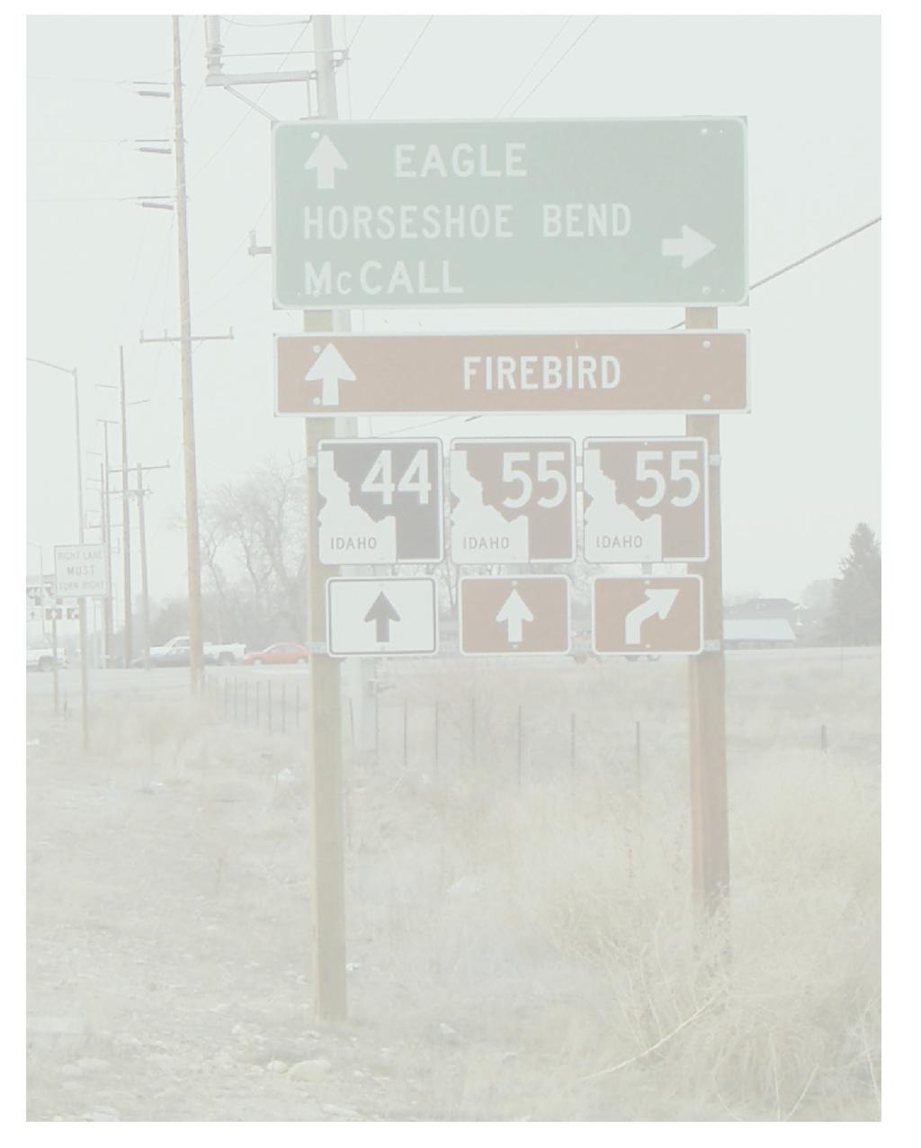
3 SUPPORTING DATA VOLUME II Public Involvement Process and Results The public involvement process closely followed the overall State Street Corridor Study process, providing a status and obtaining input throughout the duration of the project. As shown below, the public involvement activities played a key role in the results and outcomes of the project. Technical Stage 1 Stage 2 Stage 3 Prepare existing and future conditions Technical Memo Identify 38 possible improvement options in five categories roadway management alternative transportation intersection improvements corridor appearance capacity enhancements Defined: near-term improvements; and three longterm scenarios transit conventional high capacity Established Preferred Scenario & Implementation Strategy Draft and Final Report Public Input Conduct stakeholder meetings ACHD Boise city Fire/Police ITD Garden City Businesses Conduct Public Meeting No.1 identify needs future vision Conduct Public Meeting No.2 improvement option preferences evaluation criteria weighting Northside Neighborhoods Transportation Committee is formed Conduct Public Meeting No.3 level of support for each scenario likes and dislikes of scenario components Provided for public comment State Street Corridor Study Approach The State Street Corridor Study Team understood the need for public input and therefore implemented an extensive public involvement process. The purpose of the public involvement process was to: 1) demonstrate the ongoing progress of the study to the public (education); and 2) obtain meaningful input from the public to help guide the outcome of the study. A sincere attempt was made to balance the needs of the three public groups (neighborhoods, businesses, and commuters) and incorporate their input into the ongoing technical analysis. As discussed and illustrated in the Introduction chapter, the State Street Corridor Study was conducted in essentially three stages. There was a strong public involvement component in each of those stages that was an integral part of the study approach. Three large public meetings were held in association with the three project stages. This included activities to involve both the interested and participating public agencies, as well as the general public. Meyer, Mohaddes Associates Supporting Data Volume II 1
4 In addition to the three large public meetings, the study team dedicated resources to provide information to, and obtain input from, public agencies and other interested parties to involve them in the study process and outcomes of the project. This included the following activities: Updates and workshops to the ACHD Commissioners and Boise City Council Separate meetings with Garden City staff and Council Stakeholder meetings with Boise City Police and Fire Departments, Idaho Transportation Department, COMPASS, and ValleyRide Preparatory meetings with agency representatives prior to the public meetings Special forums to involve businesses in the corridor Special meetings with the Northside Neighborhoods Transportation Committee representatives Several project meetings dedicated to the planning and execution of the public meetings The different perspectives of these groups and the input received throughout the project played an important role in guiding both the evolving project approach, as well as the outcomes of the study. The State Street Corridor Study Team believes the entire public involvement process was a tremendous success and significantly influenced the final results of the study. It also enhanced the relations between ACHD and other agencies, as well as the public. It improved the trust between these groups and will help to foster a stronger working relationship on future projects. SUPPORTING DATA VOLUME II CONTENTS The following information is contained within this Supporting Data Volume: Public Meeting #1 Results Public Meeting #2 Results Public Meeting #3 Results Northside Neighborhoods Transportation Committee Report Meyer, Mohaddes Associates Supporting Data Volume II 2
5 PUBLIC MEETING 1 RESULTS The purpose of the first State Street Corridor Study public meeting was to introduce the public to the project and how they could participate that night and into the future. The Study Team displayed State Street information boards describing the current and future traffic conditions and safety issues were in the corridor. ACHD made a 20-minute presentation about the project and the attendees then divided into 10 breakout groups, each with a leader, to express their needs and concerns. Additionally, the breakout groups focused on what their impressions were of the future vision of State Street. Meyer, Mohaddes Associates Supporting Data Volume II 3
6 ACHD State Street Corridor Study Summary of January 16, 2003 Public Meeting Meeting date and location- January 16, to 8:30 p.m. William Howard Taft Elementary 3722 Anderson St. Boise Agenda 6 p.m. Open House 6:30 p.m. Formal Presentation 7 p.m. Focus Groups Meeting purpose- Provide the public with an opportunity to Learn about the condition of State Street, why ACHD is conducting a corridor study and what a corridor study is Provide comments on their concerns and needs regarding State Street Learn how to participate in the corridor study process Anticipated use of public comments- Public meeting format- Assist the State Street corridor study team Understand the public s concerns and needs regarding State Street By identifying issues that need to be included in the corridor study Open House (Display board write up-jay) Formal Presentation Joe Rosenlund, ACHD, provided participants with information about the corridor study (why ACHD is doing, how the sturdy results will be used and what is the study process) and the current state of State Street. Break Out Groups Participants were divided into ten groups. In a facilitated discussion they were asked: Describe the experience you would like to have traveling down State Street in What are your transportation needs for State Street? Facilitators recorded participant s comments and asked for prioritization of the needs (using orange dots). Notification process- Mailing Postcards announcing the public meeting were mailed to ZIP codes along the corridor (10,000) Meyer, Mohaddes Associates Supporting Data Volume II 4
7 Project stakeholder database (426) Display ad/ media notices Display adds announcing the public meeting were placed in the o Boise Metro Chamber of Commerce newsletter o Idaho Statesman o The Idaho Statesman ran a full article on the front page of the local section Press releases were sent to local newspapers, television and radio stations. Display ad/ media notices Two billboards were posted along the State Street corridor Sandwich boards Sandwich boards were posted along the entire State Street Corridor study area announcing the meeting. Attendance- Number or participants who signed-in Number of comment sheets returned on January 16th Number of comment sheets and returned after the 16th 255 (nearly 300 total in attendance) Analysis- The purpose for hosting the first public meeting was met. The attendance of the public meeting was overwhelming! Comments from public meeting were recorded verbatim and are attached to this summary. The findings in this summary are derived from the categorization and tabulation of recorded responses. This process is not statistically valid but provides an overview of the recorded opinions. Vision Summary Citizens would like a beautified corridor that allows pedestrians, cyclists and vehicles to move safely, has access to businesses and public transportation and traffic signals are coordinated. Citizens do not have agreement on desired roadway improvements and levels access management. They do believe State Street is part of an entire transportation system and the system needs to be considered when making decisions. Meyer, Mohaddes Associates Supporting Data Volume II 5
8 Needs Summary 1. Facilitate public transportation (Monorail, light rail, free buses, park and ride lots, HOV lanes for mass transit carpooling, commute tax for mass transit) 2. Improve signal coordination 3. Reinstate Hill side belt way 4. Widen Hill Road to relieve traffic from State Street 5. Provide alternative pathways for cyclist, pedestrians and access to businesses 6. Improve State Street before adding more traffic Discussion Questions- How would you like respond to the comments received? Caution we did not get commuter comments Next public meeting Issues for improvement in next public meeting Bigger facility Better organization to handle the crowd More communicative display boards Documentation of public comments Attachments See following pages for both comments at a glance. A second document is provided that includes verbatim transcription of comments. Display ad Press Release Post Card Bill Board Comment sheets Fact Sheet Meyer, Mohaddes Associates Supporting Data Volume II 6
9 Public Meeting Comments At A Glance Summary of State Street Corridor January 16, 2002 Public Meeting VISION Beautification (Boulevard Concept), Pedestrian and Bicyclist Gateway (see 1997 comp plan), landscaping, sidewalks and is pleasant Model Curtis Road, Attractive businesses, berms Pedestrian facilities will allow walking to local businesses Need separate lanes for bikes, extend greenbelt Tree-lined, well lighted, safe for pedestrians and bikes Eliminate jay walkers, build pedestrian sky bridges, pedestrian crossings Underground utilities Notable comments: No comments stating beautification was not important No comments stating pedestrians or bikes are not important Mentioned in 10 groups Roadway Improvements and Changes to Speed Limit Sunken or elevated roadway (outer lanes for local traffic) High speed 55 mph, higher speed, expressway More turning lanes HOV Lanes Lower speed (lower speed by school zones) No further widening Reversible lanes One way couplet (Adams/State) 2 more lanes Safety Even/continuous flow Not a major thoroughfare No left turns Limit additional traffic Notable comments: Mentioned in 10 groups No overwhelming consensus on speed or lane expansion Public Transportation and Alternative Modes Rail, monorail, light rail, sunken or elevated rail, cable cars Buses, car pooling, park and ride lots Public transportation needs to be dependable and attractive Buses should stop every 400 yards Notable comments: No non-supportive public transportation or alternative mode comments Meyer, Mohaddes Associates Supporting Data Volume II 7
10 were recorded Mentioned in nine groups No buses should stop on State in thru lanes Non-State Street Improvements Develop alternate routes Extend Five Mile/Maple Grove onto State Street then onto Hill Road Hill side belt route Need more n/w corridors Interconnectivity/truly integrated transportation system Loop highway Expand So. Eagle Road to I-84 to relieve traffic on State Street Notable comments: Mentioned in eight groups Access Less local access, limitations in access Freeway access to State Street Easy on and easy off, easy access to businesses More neighborhood connectivity (alternative ways to enter State Street) Controlled access Frontage Roads are needed Notable comments: Mentioned in nine groups No consensus for or against increased access Signals Coordinated, synchronized and smarter signals Smarter traffic management Notable comments: Mentioned in four groups Other notable comments Control density, higher density developments, Maintain businesses Leave State Street alone Expand grid network from Cloverdale over to Hill and State Limit commercial vehicles Stagger work times downtown Increase set backs Safety for outlying commuters Vision Summary Citizens would like a beautified corridor that allows pedestrians, cyclists and vehicles to move safely, has access to businesses and public transportation and traffic signals are coordinated. Citizens do not have agreement on desired roadway improvements and levels access management. They do believe State Street is part of an entire transportation system and the system needs to be considered when making decisions. Meyer, Mohaddes Associates Supporting Data Volume II 8
11 Summary of State Street Corridor January 16, 2002 Public Meeting NEEDS (top three needs in each group) Group 1 Group 2 Group 3 Group 4 Group 5 1 Highway 55 crossing to Chinden (More N/S connections) 2 Landscaped corridor 3 Travel reduction strategies, telecommuting, staggered shifts, job/housing together, TDM 1 Do State Street before Hill and 36 th 2 Don t do anymore projects that add traffic to State until it s ready for it 3 Use good engineering /Not politics 1 Right turn lane from Collister onto State 2 Provide alternative pathways for cyclist and pedestrians away from State Street (but with access to businesses and schools) 3 An alternate route 3 Back access (off State St.) (Pathways) for pedestrians and cyclists 1 First improve State Street before add traffic 2 Need to facilitate efficient public transit 3 Limited river crossings 3 Lack of ped/bike facilities 1 HOV lanes mass transit carpooling 2 All road widening to the south not north 2 Commute tax tolls (mass transit) 2 Park and Ride lots 2 Monorail Group 6 Improve signal coordination Widen Hill Rd. to relieve traffic from State Street Divert bike traffic to greenbelt Free bus transit Meyer, Mohaddes Associates Supporting Data Volume II 9
12 Group 7 Group 8 Group 9 1 Synchronized traffic lights 2 Moving more people - safer, less congestion 3 Better visually, business beatification 1 Widen Hill Rd. to relive traffic from going onto State Street 1 Improve signal Coordination 2 Light rail system 3 Free bus/transit 1 Reinstate Hillside beltway 2 Underground utilities 3 Bike lanes separated sidewalk or extend greenbelt 3 Monorail Group 10 1 Another connector N/W end 2 Get back to original vision of gateway (comp plan 1997) 2 No buses stopping in State on thru lanes 3 Interconnectivity (State/44/55/I-84) 3 Overpasses/underpasses on arterials 3 One-way / couplet (Adams/state) Group 11 1 Alt route 2 Synchronized signals 3 Better coordination between jurisdictions/agencies Summary of needs #1 Facilitate public transportation Monorail, light rail, free buses, park and ride lots, HOV lanes for mass transit carpooling, commute tax for mass transit #2 Improve signal coordination #3 Reinstate Hill side belt way Widen Hill Road to relieve traffic from State Street #4 Provide alternative pathways for cyclists, pedestrians and access to businesses #5 Alternate route #6 Improve State Street before adding more traffic Meyer, Mohaddes Associates Supporting Data Volume II 10
13 PUBLIC MEETING 2 RESULTS The purpose of the second State Street public meeting was to educate the public regarding the possible improvement options and then obtain their level of support (or lack of support) for each one of these options. Extensive displays with graphics and pictures were used to educate the public on each of the improvement options. They were then asked to complete a written form and indicate their level of support for each of the 38 options (1-do not support, 2-neutral, 3- support, 4-strongly support, and 5-top priority). Meyer, Mohaddes Associates Supporting Data Volume II 11
14 State Street Corridor Study Summary Results From Second Public Meeting (May 1, 2003) General The State Street Corridor Study Team conducted a second Public Meeting on May 1, The purpose of the meeting was to present a comprehensive list of potential improvement options (in five categories) and elicit input from the public regarding their support, or lack of support, for each improvement option. In addition, we asked them to rank the relative importance of a set of evaluation criteria developed by the Study Team. The study Team felt the meeting was successful in achieving the purpose. The following general information is pertinent: 150 attendees signed-in (of which 87 were not already in the database, indicating they were new to the process) Received 121 Your Priority (relative ranking of evaluation criteria) sheets, of which 17 were from businesses Collected between score sheets in each improvement option station, many of which included written comments Received 34 additional comment sheets It is important to note that the following pages are a summary only and those who are interested in further detail should review the raw data and comments to obtain a complete understanding of the results of the meeting. Summary Findings The following statements represent the summary findings. Please read the pages that follow to better understand the results to each improvement option category and evaluation criteria ranking. A majority of the meeting participants were serious and conscientious regarding their review of the material and input they provided. Of the five improvement option categories, most strongly supported were improvements to Roadway Management, Alternate Transportation, and Corridor Appearance. More controversial and receiving mixed-to-negative responses were improvements to Intersection Operations and Roadway Capacity. Of the 38 individual potential improvement options, 14 were most strongly supported (received a strongly support or top priority scoring), 11 were moderately supported, 6 had mixed results (large numbers of respondents both strongly support and do not support the option, indicating no consensus among these improvements), and 5 were not supported (over 25% do not support AND under 25% strongly support or better). In general, most of the near-term improvement options were supported and some of the longerterm, more costly options were either mixed or not supported. Received excellent input regarding the evaluation criteria ranking. From this information, weighted criteria were established for both motorists and businesses owners separately. Comments received were both in support of and not in support of selected improvement options, but generally consistent with the scoring received. The summary of comments indicated on the following sheets were only those written on the score sheets. Comments from the separate comments sheets and are not included in this summary. Several comments commended ACHD for the meeting material and approach. Meyer, Mohaddes Associates Supporting Data Volume II 12
15 Improve Roadway Management Scoring ( responses) Tallies* Percentages Improvement Option Average* Note A Note B Intelligent Transportation Systems % 58% Employer Assistance Programs % 39% Flex-time % 36% Telecommuting % 28% Signal Spacing/Signal Consolidation % 72% Driveway Spacing/Consolidation/Parking % 53% Medians/U-turns % 43% Frontage/Backage Roads % 48% * 1=Do not support; 2=Neutral; 3=Support; 4=Strongly Support; 5=Top Priority Notes: (A) Do not support (B) Combined strongly support and top priority Comments The following represented the majority of the comments written on the score sheets (other comments documented separately): o Divert traffic from State Street and it will not have a need for improvements (to Chinden, support new E-W corridor) o Support Employer Assistance/Flex-time/Telecommuting o Do not add new signals make the ones we have smarter o Support for frontage roads Assessment Overall: On average, there was general support for all the improvement options in this category. It appears that Roadway Management is supported by the majority of the public in attendance at the meeting. Strongest Support (over 50% strongly support or better): The three improvement options most strongly supported included Intelligent Transportation Systems, Signal Spacing/Consolidation, and Driveway Spacing/Consolidation/Parking Strategies. Moderate Support: The following improvement options were considered to be moderately supported by the public: Employer Assistance Programs Flex-time Telecommuting Medians/U-turns Mixed (indications of both do not support and strongly support ): Frontage and Backage Roads received large numbers of scores for both do not support and strongly support or better. Do Not Support (over 25% do not support AND under 25% strongly support or better): No improvement options were considered to be not supported in this category. Meyer, Mohaddes Associates Supporting Data Volume II 13
16 Improve Alternate Transportation Scoring ( responses) Tallies* Percentages Improvement Option Average* Note A Note B Park-N-Ride Lots % 51% Pedestrian Crossings % 54% Sidewalk Improvements % 56% Bicycle Network Improvements % 50% Van/Car Pools % 43% Bus Service Operations Freq. & Routes % 60% Pull-outs/Designated Stops/Bus Shelters % 67% Express Bus/Bus Rapid Transit % 54% Transit Signal Priority/Queue Jumps % 42% High Occupancy Lanes/Toll Lanes % 29% Light Rail Transit % 46% * 1=Do not support; 2=Neutral; 3=Support; 4=Strongly Support; 5=Top Priority Notes: (A) Do not support (B) Combined strongly support and top priority Comments The comments that accompanied this category were representative of the numerical results shown above. Several strong comments accompanied those improvements that are clearly supported, and many mixed comments were received on those that indicate a love it or hate it score. Several other comments suggested moving some of the longer term improvements to earlier implementation. Assessment Overall: On average, there was very strong support for all the improvement options in this category, with the exception of HOV/HOT lanes. It appears that Alternate Transportation improvements are supported by the majority of the public in attendance at the meeting. Strongest Support (over 50% strongly support or better): Park-N-Ride lots Pedestrian Crossings Sidewalk Improvements Bicycle Network Improvements Bus Service Improvements (Frequency and Routing) Pull-outs/Designated Stops/Bus Shelters Express Bus/Bus Rapid Transit Moderate Support: The two improvement options considered to be moderately supported included Van/Car Pools and Transit Signal Priority/Queue Jumps. Mixed (indications of both do not support and strongly support ): High Occupancy Vehicle/Toll lanes and Light Rail had mixed results with respondents indicating high values in both do not support and well as strongly support. In the case of HOV/HOT, several respondents provided separate scoring for HOV and HOT, indicating more support for HOV lanes and no support for toll lanes. Do Not Support (over 25% do not support AND under 25% strongly support or better): No improvement options were considered to be not supported in this category. Meyer, Mohaddes Associates Supporting Data Volume II 14
17 Scoring ( responses) Improve Intersection Operations Tallies* Percentages Improvement Option Average* Note A Note B Signal Improvements % 74% Intersection Configuration % 52% Acceleration/Deceleration Lanes % 56% Through-lane Overpass % 41% Roundabouts % 22% Couplet Intersection Design % 27% Urban Interchange % 24% * 1=Do not support; 2=Neutral; 3=Support; 4=Strongly Support; 5=Top Priority Notes: (A) Do not support (B) Combined strongly support and top priority Comments The comments included with this category are very mixed with positive and negative comments expressed on all the improvement options. No clear appeared in the review of the comments. A selection of comments included: o Overpasses will ruin another part of Boise and still won t be enough o I find it extraordinary that ACHD does not rate the effectiveness of improved signals higher. Need to make those improvement now o Roundabouts: not enough room, only if pedestrian crossing are incorporated, too expensive o Only support through-lane if go under build tunnel o There are other options (no other options offered in comments) Assessment Overall: On average, there was strong support for the near-term improvement options and very mixed for the longer-term (representing significant change) improvement options. It appears that although the respondents realize the need for intersection improvements, there is no consensus among the public in attendance at the meeting regarding how that should occur. Strongest Support (over 50% strongly support or better): The three improvement options most strongly supported included Signal Improvements, Intersection Configuration, and Acceleration/Deceleration Lanes. Moderate Support: There were no improvement options in this category. Mixed (indications of both do not support and strongly support ): Two improvement options fell in this category: Through-Lane Overpass and Couplet Intersection Design. There was no consensus among the respondents for these improvement options. Do Not Support (over 25% do not support AND under 25% strongly support or better): Two improvement options were clearly not supported by the respondents. Those included the Roundabout and Urban Interchange. Meyer, Mohaddes Associates Supporting Data Volume II 15
18 Scoring ( responses) Improve Corridor Appearance Tallies* Percentages Improvement Option Average* Note A Note B Landscaping/Lighting/Shoulder Improvements % 47% Corridor Beautification % 45% Neighborhood Interconnectivity % 44% Commercial Redevelopment on State % 49% Commercial Redevelopment off State % 35% Node Development % 50% * 1=Do not support; 2=Neutral; 3=Support; 4=Strongly Support; 5=Top Priority Notes: (A) Do not support (B) Combined strongly support and top priority Comments The comments included mostly support for the improvement options, with a mixture of ideas expressed on how that should be achieved. A selection of comments included: o Landscaping/lighting would be nice, but don t want to lose road movement space no trees in median keep traffic moving o Do not impact existing local businesses for the sake of moving traffic only! o The market will determine what commercial building will be included on State Street o No more light pollution o Node Development: hurry up! Do Collister first o Node Development: encourages healthy commercial sector and high density housing. The best recipe for future health of the city corridor o No more traffic on Hill Road and no change to Hill Road. Maximize use of space that s already avail on State Street o Find and construct alternate route... move the flow of traffic on State Street to Chinden Assessment Overall: On average, there was moderate support for most of the improvement options in this category, with only one being considered strongly supported or better. It appears that the public supports corridor appearance improvements, but there was no clear consensus on how that should be achieved. Strongest Support (over 50% strongly support or better): Only one improvement option reached the 50% level of strongly support or better: Node Development. Several others came close (see above), but will be identified in the moderately support category. Moderate Support: Most of the improvement options fell in this category. They include: Landscaping/Lighting/shoulder improvements Corridor Beautification Neighborhood interconnectivity Commercial redevelopment (on and off State Street) Mixed (indications of both do not support and strongly support ): No improvement options were included in this category. Do Not Support (over 25% do not support AND under 25% strongly support or better): No improvement options were included in this category. Meyer, Mohaddes Associates Supporting Data Volume II 16
19 Scoring ( responses) Improve Roadway Capacity Tallies* Percentages Improvement Option Average* Note A Note B Selected Widening % 39% Reversible Lanes % 36% 7-Lane Corridor % 20% Boulevard Concept % 39% Elevated Center Lanes % 17% Expressway (limited access) % 23% * 1=Do not support; 2=Neutral; 3=Support; 4=Strongly Support; 5=Top Priority Notes: (A) Do not support (B) Combined strongly support and top priority Comments Most of the comments were not supportive of the improvement options in this category. Selected comments included: o Options would be too much impact on existing local businesses inside Boise city limits o Options good for engineers, not for community o State Street can not accept any more lanes without destroying businesses and homes o Reversible lanes: Do now; Should be in less than 5-years; NOT in 15 years, 1 year! o Boulevard/Elevated: combine with one way traffic open for heavy traffic direction o Elevated lanes for public transit only o Elevated lanes: too expensive o Increased capacity will destroy quality of life o Boulevard Concept: Maybe; Limited locations?; can t see on State St. Assessment Overall: On average, there was no real support for any of these capacity improvement options. The Boulevard Concept had the strongest support with 39% of respondents strongly supporting it or better. Most of the responses were either not supportive or had mixed responses. Strongest Support (over 50% strongly support or better): No improvement option was included in this category. Moderate Support: The Boulevard Concept was the only improvement option that was considered to be moderately supported by the attendees. Mixed (indications of both do not support and strongly support ): Two of the improvement options fell in this category. They include: Selected Widening Reversible Lanes Do Not Support (over 25% do not support AND under 25% strongly support or better): The following three improvement options met this criteria: 7-Lane Corridor Elevated Center Lane Expressway (limited access) Meyer, Mohaddes Associates Supporting Data Volume II 17
20 Priorities for Scenario Evaluation In addition to the input for various improvement options, we asked the public for their relative ranking of criteria measures in order to establish a weighted average to be used to evaluate future scenarios. We collected 121 Priority sheets (17 who identified themselves as owning a businesses on State Street). Respondents were asked to rank the criteria from 1 to 7, with 1 being the most important (i.e., the lower the value, the more important). The following are the results. Averages Motorists Businesses Evaluation Criteria Motorists Business Moving traffic Improving use of transit Improving use for bicycles Beautifying the corridor Supporting business activities Protecting Neighborhoods Cost This translated in the following weighted averages for each evaluation criteria EVALUATION CRITERIA Motorists Businesses Combined Moving traffic 19% 21% 20% Improving use of transit 16% 13% 16% Improving use for bicycles 13% 9% 13% Beautifying the corridor 11% 12% 12% Supporting business activities 11% 21% 13% Protecting Neighborhoods 19% 14% 18% Cost 9% 10% 9% Assessment The following observations are made: There were only 16 businesses represented in the numbers (one business did not fill out the form properly to be counted), therefore the results may not be representative of all businesses along State Street Overall, the values are very similar regardless of user category Both the general motorists and businesses rank moving traffic as their number 1 criteria Not surprising, the supporting business activities criteria was ranked substantially higher in importance to the businesses that responded Meyer, Mohaddes Associates Supporting Data Volume II 18
21 Strongest Improvement Options Level of support for all of the 38 improvement options, ranked by strongest support as provided by attendees at the second State Street Corridor Study public meeting Strongest Do Not Improvement Options Averages Support Support Signal Improvements % 3.8% Signal Spacing/Signal Consolidation % 5.7% Pull-outs/Designated Stops/Bus Shelters % 10.2% Bus Service Improvements - Frequency and Routing % 7.5% Intelligent Transportation System Applications % 4.8% Sidewalk Improvements % 5.3% Acceleration/Deceleration Lanes % 7.9% Express Bus/Bus Rapid Transit % 14.3% Pedestrian Crossings % 4.5% Driveway Spacing/Driveway Consolidation/Parking Strategies % 12.9% Intersection Configuration % 7.0% Park-N-Ride Lots % 9.8% Bicycle Network Improvements % 14.5% Node Development % 16.1% Commercial Redevelopment - On State % 18.1% Frontage/Backage Roads % 22.6% Landscaping/Lighting/Shoulder Improvements % 14.4% Light Rail Transit % 27.9% Corridor Beautification % 15.7% Neighborhood Interconnectivity % 18.9% Van/Car Pools % 7.8% Medians/U-turns % 16.4% Transit Signal Priority/queue Jumps % 15.4% Through-lane Overpass % 29.9% Employer Assistance Programs % 14.2% Selected Widening % 20.8% "Boulevard" Concept % 22.1% Reversible Lanes % 36.9% Flex-time % 14.3% Commercial Redevelopment - Off State % 13.5% High Occupancy Lanes/Toll Lanes % 41.0% Telecommuting % 15.4% Couplet Intersection Design % 34.4% Urban Interchange % 42.5% Expressway (Limited Access) % 55.6% Roundabouts % 42.6% 7-Lane Corridor % 48.8% Elevated Center Lanes % 54.4% Meyer, Mohaddes Associates Supporting Data Volume II 19
22 PUBLIC MEETING 3 RESULTS The purpose of the third, and final, public meeting was to illustrate the near-term improvement options and three possible long-term scenarios, and obtain the public feedback on their level of support for each of the scenarios. In the previous meetings, it was observed that the attendance was primarily from the neighborhoods and in order to for the Study Team to achieve one of its primary goals (to balance the needs of neighborhoods, businesses, and commuters), we needed to have a more balanced attendance at this third meeting. Several things were done to achieve this. First, two meeting dates were established at different locations in the corridor on the same week. They were located in empty storefronts on State Street which would increase the ease to attend the meeting and reduce the walking distance required (experienced at the Fairgrounds). Second, the outreach was expanded to businesses. Third, the outreach was expanded to residents west of Glenwood Boulevard (Eagle, Star, etc.). Fourth, efforts were made to expand general advertising of the meeting through billboards and media coverage. The attendance at the second meeting was half that of the first meeting, however, the attendance at the third meeting (both nights) was almost three times that of the second meeting. Moreover, the mix of attendees were significantly improved, with nearly a third having addresses west of Glenwood (representing commuters), and a total of 50 different businesses. The Project Study Team was pleased with the turnout and felt the input received more closely resembled the users of the entire State Street corridor. The total attendance at each of the two meeting nights was fairly close, with 232 and 211 individuals present at each of the meetings, respectively. The attendees were asked to rate each overall scenario based on their level of support (1-do not support, 2-neutral, 3-support, 4-strongly support, and 5-top priority). Each scenario depicted a very different possible future vision for State Street. The responses were mixed. Within these scenarios, there was something to like and dislike for each individual and the input received reflected both strongly supportive and strongly against certain scenarios. The comments received generally reflected the numerical responses. Meyer, Mohaddes Associates Supporting Data Volume II 20
23 State Street Corridor Study Summary Results From Third Public Meeting (Sept 30 and Oct 2, 2003) General On September 30 th and October 2 nd, 2003, the State Street Corridor Team conducted its third and final public meeting. Two meetings were scheduled to accommodate citizens schedules, with the same material presented both nights. The purpose of the meeting was primarily to present three different scenarios that represent possible visions for the future of the State Street corridor and elicit input from those in attendance regarding their support for scenarios and their likes and dislikes of the elements of each. The attendance at each meeting was excellent (see table below). ATTENDANCE September 30 October 2 Total Total individuals Separate addresses Businesses (within the addresses) (13%) Addresses west of Glenwood/Gary (32%) Neighborhoods along the corridor encouraged attendance by distributing flyers, and additional advertising through a monthly City of Eagle mailing also help generate attendance. The State Street Team was especially pleased to see so many businesses and people west of Glenwood/Gary (presumed to be commuters). These two groups were not present at these levels in the first two meetings and the Team felt it was very important to have a balanced audience and input. The other attendees mostly represented the third stakeholder group, neighborhoods, who have strongly participated throughout the process. The three scenarios presented at the meeting included a Transit Scenario, Conventional Scenario, and High Capacity Scenario (each of these are discussed in more detail below). The meeting attendees were asked two questions. The first asked, how strongly do you support this scenario? (1- do not support, 2- neutral, 3- support, 4- strongly support, and 5- top priority). The second asked them to check what they liked and disliked about the scenario (scenario elements were provided for each scenario). Nearly 1,000 input sheets were received from both meetings which also included comments. This information was placed in an excel spreadsheet for analysis. The overall support for each scenario, by meeting, is provided below: SCENARIO September 30 October 2 Total Transit Conventional High Capacity The results were similar for both meetings. In general it is observed that the attendees of the October 2 nd meeting, with a higher percentage of neighborhoods in attendance, rated the Transit Scenario slightly higher and the High Capacity Scenario had a slightly lower rating. The ratings for the Conventional Scenario were very close for both meetings. It is also interesting to note that although the Transit Scenario was clearly rated higher than the other two at both meetings, none of the scenarios were strongly supported. We can therefore say that the Transit Scenario was supported, the Conventional Scenario was in the middle between support and neutral, and the High Capacity Scenario was at the level of neutral. Meyer, Mohaddes Associates Supporting Data Volume II 21
24 A significant number of comments were also received and will be included in a separate document. Additional information that will be considered in the next steps of the project include input from the Northside Neighborhood Transportation Committee s neighborhood meetings held in July and August. The remainder of this meeting summary discusses additional detail for each of the scenarios. Also included is summary information directly from the excel spreadsheet for both meetings. Transit Scenario The average ratings of 3.04 and 3.19 for the September 30 th and October 2 nd meetings, respectively, are important, but more interesting can be the tallies for each rating into the 1-5 categories and the totals from both meetings. This data is shown below. Meeting tally/percent 1- do not support 2- neutral 3-support 4- strong support 5- top priority 4 & 5 s Sept 30th Tally Percent 21.1% 15.8% 25.7% 13.2% 24.3% 37.5% Oct 2nd Tally Percent 17.4% 18.6% 21.1% 13.7% 29.2% 42.9% Totals Tally Percent 19.2% 17.3% 23.3% 13.4% 26.8% 40.3% The results from the two meetings are extremely similar, with slightly more of the attendees at the October 2 nd meeting identifying the Transit Scenario as their top priority. Also interesting was the fact that the distribution across the 1-5 rating scale was fairly even. There were approximately as many people that said they did not support or were neutral on this scenario as there were that said they either support or strongly support the scenario. Clearly this scenario received the most top priority votes than either of the other two scenarios for either meeting. Input was also gathered regarding the likes and dislikes of the Transit Scenario elements. The table below identifies those elements and the average responses for both meetings. A 1 was assigned to the liked elements, a -1 was assigned to the disliked elements, and if it was not marked or was marked in the middle, a 0 was assigned. The values in the table indicate the level of like (positive number) or dislike (negative number) for each element, on average. The closer the value is to 1 or -1 indicates their increased level of like or dislike, respectively. Meyer, Mohaddes Associates Supporting Data Volume II 22
25 TRANSIT SCENARIO ELEMENTS September 30 th October 2 nd Total HOV in curb lane emphasis Transit on north side emphasis Additional lanes dedicated to transit Rapid bus Light rail option Node development on State Street Couplet intersection approach Themed architecture at nodes with public art at selected loc Separated pedestrian/bike pathways Bus stops in traffic flow Bus pull-outs on north side of roadway Level of access control Park & ride lots With very few significant differences, it can be stated that the participants at the two meetings generally had the same impression of this scenario. The most strongly supported elements included rapid bus, node development, separated ped/bike paths, bus pull-outs, and park & ride lots. Clearly, they did not support bus stops in the traffic flow and desire them to be in separate pull-outs. Individual tallies are provided in the data at the end of this summary. Meyer, Mohaddes Associates Supporting Data Volume II 23
26 Conventional Scenario The average ratings of 2.52 and 2.40 for the September 30 th and October 2 nd meetings, respectively, are important, but more interesting can be the tallies for each rating into the 1-5 categories and the totals from both meetings. This data is shown below. Meeting tally/percent 1- do not support 2- neutral 3-support 4- strong support 5- top priority 4 & 5 s Sept 30th Tally Percent 21.4% 28.3% 32.4% 13.1% 4.8% 17.9% Oct 2nd Tally Percent 30.2% 24.1% 27.8% 11.1% 6.8% 17.9% Totals Tally Percent 26.1% 26.1% 30.0% 12.1% 5.9% 17.9% Again, the results from the two meetings are extremely similar, with more of the attendees at the October 2 nd meeting identifying the Conventional Scenario as not supported. Unlike the Transit Scenario, the distribution across the 1-5 rating scale was not even. Clearly, it was weighted toward the left hand side of the table indicating a do not support to support stance, on average. Therefore, this scenario resulted in a score half way between neutral and support. Input was also gathered regarding the likes and dislikes of the Conventional Scenario elements. The table below identifies those elements and the average responses for both meetings. A 1 was assigned to the liked elements, a -1 was assigned to the disliked elements, and if it was not marked or was marked in the middle, a 0 was assigned. The values in the table indicate the level of like (positive number) or dislike (negative number) for each element, on average. The closer the value is to 1 or -1 indicates their increased level of like or dislike, respectively. TRANSIT SCENARIO ELEMENTS September 30 th October 2 nd Total Additional vehicle lanes Urban interchanges at intersections Shoulder treatments with bike lanes Frontage and backage roads Continued existing development pattern Widened sidewalks Curb/gutter/storm drain facilities Level of access control Landscaped medians In most cases the averages were consistent between the two meetings, with two clear differences. The input on the top two elements were significantly different between the two meetings. The September 30 th group indicated a fairly high like for additional vehicle lanes and urban interchanges at intersections, while the October 2 nd group s values were significantly lower (although still positive). The most strongly supported elements included shoulder treatments, curb/gutter/storm drain facilities, and landscaped medians. Both meeting participants indicated a clear neutral stance on whether to continue existing development patterns. Individual tallies are provided in the data at the end of this summary. Meyer, Mohaddes Associates Supporting Data Volume II 24
27 High Capacity Scenario The average ratings of 2.14 and 1.84 for the September 30 th and October 2 nd meetings, respectively, clearly indicate that on average participants were neutral, but more interesting can be the tallies for each rating into the 1-5 categories and the totals from both meetings. This data is shown below. Meeting tally/percent 1- do not support 2- neutral 3-support 4- strong support 5- top priority 4 & 5 s Sept 30th Tally Percent 57.1% 4.5% 14.3% 15.6% 8.4% 24.0% Oct 2nd Tally Percent 64.3% 9.4% 9.9% 11.1% 5.3% 16.4% Totals Tally Percent 60.9% 7.1% 12.0% 13.2% 6.8% 20.0% Once again, the results from the two meetings are extremely similar, with more of the attendees at the October 2 nd meeting identifying the High Capacity Scenario as not supported. This scenario received the most do not support votes among the other scenarios, reflecting the lower overall rating, however approximately 20% of the respondents marked this scenario as either strong support or top priority. This scenario got deemed the love it or hate it scenario, with very few people in the middle. Input was also gathered regarding the likes and dislikes of the High Capacity Scenario elements. The table below identifies those elements and the average responses for both meetings. A 1 was assigned to the liked elements, a -1 was assigned to the disliked elements, and if it was not marked or was marked in the middle, a 0 was assigned. The values in the table indicate the level of like (positive number) or dislike (negative number) for each element, on average. The closer the value is to 1 or -1 indicates their increased level of like or dislike, respectively. TRANSIT SCENARIO ELEMENTS September 30 th October 2 nd Total 3-lane elevated section One elevated lane for transit/hov Maintain 5-lane section at grade Pedestrian and bike facilities Development nodes at access points Structural art on elevated supports Landscaping Lighting features Level of access control In general the responses at both meetings are consistent. The respondents at the October 2 nd meeting were generally less supportive of this scenario. The elements that were not supported included the 3-lane elevated section, one elevated lane used for transit/hov, and using structural art to help the aesthetics of the concrete supports. Some elements that were moderately supported included pedestrian and bike facilities, development nodes at access points, and landscaping features. Individual tallies are provided in the data at the end of this summary. Meyer, Mohaddes Associates Supporting Data Volume II 25
28 Other Assessment The scenario elements were reviewed to determine the likes and dislikes regardless of which scenario they were associated with. The information below illustrates this data from highly liked to disliked. Scenario Elements Value Overall Assessment Park & Rides 0.67 Curb/Gutter/Storm drain facilities 0.60 Separated pedestrian/bike pathways 0.57 Bus pull-outs on north side of roadway 0.55 Rapid bus 0.54 Shoulder treatments with bike lanes 0.50 Landscaped medians 0.43 Node development on State Street 0.43 Additional lanes dedicated to transit 0.39 W idened sidewalks 0.39 LIKED Pedestrian and bike facilities 0.38 Level-of-access control 0.36 Frontage/backage roads 0.35 Level of access control 0.34 "Themed" architecture at nodes 0.33 Development nodes at access points 0.33 Landscaping 0.30 Additional Vehicle Lanes 0.30 Maintain 5-lane section at grade 0.27 urban interchanges at intersections 0.27 HOV in curb lane emphasis 0.26 Light Rail option 0.26 Lighting features 0.24 Couplet intersection approach 0.23 Transit on North side emphasis 0.18 Level-of-access control 0.15 Neutral Continued existing development pattern Structural art on elevated supports One elevated lane for transit/hov lane elevated section DISLIKED Bus stops in traffic flow As can be seen, the majority of the elements were liked by the participants, on average. The most highly regarded elements included park n ride lots, curb/gutter improvements, separated pedestrian/bike pathways, bus pull outs, rapid bus, and shoulder treatments with bike lanes. The two elements most disliked included the 3-lane elevated section and the bus stops in traffic flow. This information will be used by the State Street Corridor Study team to develop the details of the preferred scenario and build an implementation strategy to achieve that reality over the next several years. Meyer, Mohaddes Associates Supporting Data Volume II 26
State Street Corridor Study Final Report. Table of Contents
 Table of Contents Executive Summary... 1 Introduction... 4 Problem Statement... 4 Study Purpose... 4 Purpose of this Document... 4 Corridor Characteristics... 6 Existing and Future... 7 Study Approach...
State Highway 44/State Street High Capacity Corridor
 Background State Highway 44/State Street runs from I-84 in Canyon County through parts of the cities of Middleton, Star, Eagle, and Garden City to downtown Boise. It is a commuter route from several communities
City of Novi Non-Motorized Master Plan 2011 Executive Summary
 City of Novi Non-Motorized Master Plan 2011 Executive Summary Prepared by: February 28, 2011 Why Plan? Encouraging healthy, active lifestyles through pathway and sidewalk connectivity has been a focus
HARRISON STREET/OAKLAND AVENUE COMMUNITY TRANSPORTATION PLAN
 HARRISON STREET/OAKLAND AVENUE Community Workshop #4: Draft Plan Review December 3, 2009 D E S I G N, C O M M U N I T Y & E N V I R O N M E N T INTRODUCTIONS Key Project Staff: Alisa Shen, Project Manager,
Fairview and Main Local Streets Improvement Plan
 PIM#2 Summary Report Meeting Format Date & Time: Location: Address: Prepared By: Community Open House August 11, 2016 5:30 p.m. 7:30 p.m. Red Lion Hotel 1800 W. Fairview Avenue, Boise Stephanie Borders,
Lee s Summit Road Improvement Study Public Open House June 7, 2007 Summary of Comment Card Responses
 Lee s Summit Road Improvement Study Public Open House June 7, 2007 Summary of Comment Card Responses Introduction At the Lee s Summit Road Improvement Study Public Open House held Thursday, June 7, 2007
Regional Transportation Needs Within Southeastern Wisconsin
 Regional Transportation Needs Within Southeastern Wisconsin #118274 May 24, 2006 1 Introduction The Southeastern Wisconsin Regional Planning Commission (SEWRPC) is the official areawide planning agency
4 MOBILITY PLAN. Mobility Plan Objectives. Mobility Context. 1. Integrate with Local and Regional Transit Improvements
 Harbor Mixed Use CHAPTER Transit Corridor 4: Mobility Plan 4 MOBILITY PLAN Mobility Plan Objectives The Harbor Corridor Plan seeks to expand and improve the ways that people move along and through the
5.0 Roadway System Plan
 Southwest Boise Transportation Study Page 16 5.0 Roadway System Plan The Roadway System Plan outlines roadway improvements in the Initial Study Area. It forecasts future deficiencies on the arterial system,
Chapter 5 Future Transportation
 Chapter 5 Future Transportation The Future Land Use Plan identifies the desired land use designations. The land uses desired for Crozet depend, in large part, on the success of the transportation system,
City of Wayzata Comprehensive Plan 2030 Transportation Chapter: Appendix A
 A1. Functional Classification Table A-1 illustrates the Metropolitan Council s detailed criteria established for the functional classification of roadways within the Twin Cities Metropolitan Area. Table
MASTER BICYCLE AND PEDESTRIAN PLAN
 VILLAGE OF NORTHBROOK MASTER BICYCLE AND PEDESTRIAN PLAN DRAFT PLAN OPEN HOUSE May 2, 2018 AGENDA 1. Community Engagement 2. Vision and Goals 3. General Structure of Plan 4. Recommendations Overview 5.
City of Davis East Covell Corridor Plan
 Community Open House #2 January 22, 2014 6:00 8:00 p.m. Veterans Memorial Center, Club Room City of Davis Introduction The (ECCP) is a taking a comprehensive look at the existing transportation systems
State Street and Pierce Park Lane Intersection Concept Report
 State Street and Pierce Park Lane Intersection Prepared for September 2017 Prepared by CITATION Parametrix. 2017. State Street & Pierce Park Lane Intersection. Prepared by Parametrix, Boise, ID. September
Interstate 66 Tier 1 Environmental Impact Statement. Cooperating and Participating Agencies Meeting March 19, 2012
 Interstate 66 Tier 1 Environmental Impact Statement Cooperating and Participating Agencies Meeting March 19, 2012 Chris Collins Virginia Department of Transportation, Environmental Division Meeting Agenda
CONNECTING PEOPLE TO PLACES
 CONNECTING PEOPLE TO PLACES 82 EAST BENCH MASTER PLAN 07 Introduction The East Bench transportation system is a collection of slow moving, treelined residential streets and major arteries that are the
Sixth Line Development - Transit Facilities Plan
 Memorandum Date: November 13, 2012 To: From: c.c. Subject: Rob Freeman (Freeman Planning) Kevin Phillips Sixth Line Development - Transit Facilities Plan 33016631 This memo was prepared to review the transit
Solana Beach Comprehensive Active Transportation Strategy (CATS)
") Solana Beach Comprehensive Active Transportation Strategy (CATS) 3.0 Goals & Policies The Solana Beach CATS goals and objectives outlined below were largely drawn from the Solana Beach Circulation Element
Solana Beach Comprehensive Active Transportation Strategy (CATS) 3.0 Goals & Policies The Solana Beach CATS goals and objectives outlined below were largely drawn from the Solana Beach Circulation Element
Corridor Advisory Group and Task Force Meeting #10. July 27, 2011
 Corridor Advisory Group and Task Force Meeting #10 July 27, 2011 1 Agenda Recap CAG/TF #9 Public Meeting #2 Summary Single Mode Alternatives Evaluation Results Next Steps 2 3 CAG/TF #9 Recap CAG /TF #9
5 CIRCULATION AND STREET DESIGN
 5 CIRCULATION AND STREET DESIGN This chapter describes circulation and streetscape improvements proposed for the Northwest Chico Specific Plan Area. It includes detailed design specifications for existing
CITY OF COCOA BEACH 2025 COMPREHENSIVE PLAN. Section VIII Mobility Element Goals, Objectives, and Policies
 CITY OF COCOA BEACH 2025 COMPREHENSIVE PLAN Section VIII Mobility Element Goals, Objectives, and Policies Adopted August 6, 2015 by Ordinance No. 1591 VIII MOBILITY ELEMENT Table of Contents Page Number
Classification Criteria
 SCHEDULE D TO RECOMMENDED OFFICIAL PLAN AMENDMENT NO. 40 SCHEDULE C-4 Road Criteria Criteria Traffic Service Objective Land Service/Access Typical Daily Traffic Volume Flow characteristics Travel Speed
PEDESTRIAN ACTION PLAN
 ATTACHMENT 2 CITY OF SANTA MONICA PEDESTRIAN ACTION PLAN CITY OF SANTA MONICA PEDESTRIAN ACTION PLAN This page intentionally left blank EXECUTIVE SUMMARY CHAPTER 1 EXECUTIVE SUMMARY Setting the Stage
Los Altos Hills Town Council - June 18, 2015 Palo Alto City Council June 22, AGENDA ITEM #2.B Presentation
 Los Altos Hills Town Council - June 18, 2015 Palo Alto City Council June 22, 2015 AGENDA ITEM #2.B Presentation Previous Presentations Los Altos Hills Town Council in May 2014 and February 2015 Palo Alto
Corporate. Report COUNCIL DATE: June 26, 2006 NO: C012 COUNCIL-IN-COMMITTEE. TO: Mayor & Council DATE: June 22, 2006
 Corporate NO: C012 Report COUNCIL DATE: June 26, 2006 COUNCIL-IN-COMMITTEE TO: Mayor & Council DATE: June 22, 2006 FROM: General Manager, Engineering FILE: 0410-20(MoT/Gate) SUBJECT: Surrey Response on
Outreach Approach RENEW SF served as the primary liaison with the North Beach community; the Chinatown. Executive Summary
 Executive Summary Executive Summary The Columbus Avenue Neighborhood Transportation Study s objective is to identify changes to transportation infrastructure and policies that could enhance the livability
Exhibit 1 PLANNING COMMISSION AGENDA ITEM
 Exhibit 1 PLANNING COMMISSION AGENDA ITEM Project Name: Grand Junction Circulation Plan Grand Junction Complete Streets Policy Applicant: City of Grand Junction Representative: David Thornton Address:
Online Open House Survey Report. December 2016
 December 216 I. OVERVIEW & OUTREACH SUMMARY Introduction Washington County evaluated long-term transportation investments and strategies as part of the Transportation Futures Study. The purpose of the
TRANSPORTATION NEEDS ASSESSMENT
 TRANSPORTATION NEEDS ASSESSMENT A travel demand analysis was carried out to determine the operational issues and the potential benefit that adding traffic capacity would have on the road network. All the
Transportation Master Plan Advisory Task Force
 Transportation Master Plan Advisory Task Force Network Alternatives & Phasing Strategy February 2016 BACKGROUND Table of Contents BACKGROUND Purpose & Introduction 2 Linking the TMP to Key Council Approved
Terwillegar Drive Expressway Draft Concept Plan
 Terwillegar Drive Expressway Draft Concept Plan Anthony Henday Drive to Whitemud Drive November 28 5:00-8:00 p.m. December 1 10:00 a.m. - 3:00 p.m. Let s Talk Today you can: Learn about the new direction
Public Information and Participation Comments
 Two public meetings were held in December. The first meeting was December 6, 2011 at Mary Ellen Henderson Middle School and had 36 public attendees. The second meeting was on December 14, 2011 at the Arlington
APPENDIX D. May 22, 2002 Open House Summary and Materials
 APPENDIX D May 22, 2002 Open House Summary and Materials TH 36 Partnership Study Open House May 22, 2002 Summary of Survey Responses 1. If no new crossing of the St. Croix River is built (e.g. the existing
EXECUTIVE SUMMARY. Vision
 Vision Walking and bicycling in Salt Lake City will be safe, convenient, comfortable, and viable transportation options that connect people to places, foster recreational and economic development opportunities,
Chapter 2: Standards for Access, Non-Motorized, and Transit
 Standards for Access, Non-Motorized, and Transit Chapter 2: Standards for Access, Non-Motorized, and Transit The Washtenaw County Access Management Plan was developed based on the analysis of existing
Proposed. City of Grand Junction Complete Streets Policy. Exhibit 10
 Proposed City of Grand Junction Complete Streets Policy Exhibit 10 1 City of Grand Junction Complete Streets Policy Vision: The Complete Streets Vision is to develop a safe, efficient, and reliable travel
C C C
 C-012-001 Thank you for your support for the creation of new public space and nonmotorized access between downtown and the waterfront through the Overlook Walk, the East-West Connections, and the Promenade.
Agenda. Overview PRINCE GEORGE S PLAZA METRO AREA PEDESTRIAN PLAN
 PRINCE GEORGE S PLAZA METRO AREA PEDESTRIAN PLAN May 28, 2008 Agenda Welcome and introductions Project overview and issue identification Planning context and strengths Design challenges and initial recommendations
ACTIVE TRANSPORTATION
 ACTIVE TRANSPORTATION Mobility 2040 Supported Goals Improve the availability of transportation options for people and goods. Support travel efficiency measures and system enhancements targeted at congestion
AAMPO Regional Transportation Attitude Survey
 AAMPO Regional Transportation Attitude Survey Traditionally Underserved Populations helping organizations make better decisions since 1982 2018 Submitted to the AAMPO By: ETC Institute 725 W. Frontier
A CHANGING CITY. of Edmonton, it is essential that it reflects the long-term vision of the City.
 A CHANGING CITY By the year 2040, Edmonton will be home to more than 1 million people. To accommodate growth and support a healthy and compact city, we need a new approach to development/redevelopment
Nanaimo Transportation Master Plan. Phase 1 Consultation Summary
 Nanaimo Transportation Master Plan Phase 1 Consultation Summary Transportation Advisory Committee Meeting Wednesday December 12, 2012 Agenda Study Update Phase 1 Consultation Process Phase 1 Consultation
In station areas, new pedestrian links can increase network connectivity and provide direct access to stations.
 The Last Mile Planning for Pedestrians Planning around stations will put pedestrians first. Making walking to stations safe and easy is important; walking will be a part of every rapid transit Accessible
BETHEL ROAD AND SEDGWICK ROAD CORRIDOR STUDY
 DRAFT PLAN City Council Meeting August 14, 2017 STUDY AREA Sedgwick Corridor State Route 160, principal arterial with Class 3 access management designation, commuter and freight route, connection to SR
State Highway 16 Kuna-Mora Road to Ada/Gem County Line
 Background State Highway 16 is the main commuter route from Gem County to the Treasure Valley. An increase in traffic and accidents on this highway have been a concern for several years, and the Idaho
Typical Rush Hour Commute. PennyforTransportation.com
 Typical Rush Hour Commute In the News Overview of the Plan Collaborative plan with projects in every community Prioritizing connectivity and congestion relief Dedicated transportation-specific funding;
State Highway 16/McDermott Road Kuna-Mora Road to Ada/Gem County Line
 Background State Highway 16 is the main commuter route from Gem County to the Treasure Valley. An increase in traffic and accidents on this highway have been a concern for several years, and the Idaho
State Highway 16 Kuna-Mora Road to Ada/Gem County Line
 Background Update! (February 2018): This project has been partially funded; see below. State Highway 16 is the main commuter route from Gem County to the Treasure Valley. An increase in traffic and accidents
Chapter 7. Transportation. Transportation Road Network Plan Transit Cyclists Pedestrians Multi-Use and Equestrian Trails
 Chapter 7 Transportation Transportation Road Network Plan Transit Cyclists Pedestrians Multi-Use and Equestrian Trails 7.1 TRANSPORTATION BACKGROUND The District of Maple Ridge faces a number of unique
Main-McVay Transit Study: Phase 2 Options Definition and High Level Constraints Evaluation
 Main-McVay Transit Study: Phase 2 Options Definition and High Level Constraints Evaluation APRIL 2016 A collaborative study between: For Additional Information or to Comment If you would like additional
Transportation Planning Division
 Transportation Planning Division Presentation Outline Study Tasks Recap of Previous Meetings Data Collected Focus Areas within Study Limits Design Principles Tool Box Recommended Concepts Schedule Moving
FROM: CITY MANAGER DEPARTMENT: PLANNING AND COMMUNITY ENVIRONMENT DATE: OCTOBER 4, 2004 CMR:432:04
 TO: HONORABLE CITY COUNCIL FROM: CITY MANAGER DEPARTMENT: PLANNING AND COMMUNITY ENVIRONMENT DATE: OCTOBER 4, 2004 CMR:432:04 SUBJECT: FINANCE COMMITTEE RECOMMENDATION TO ADOPT TRANSPORTATION STRATEGIC
ATTACHMENT 4 - TDM Checklist. TDM Checklist Overview
 ATTACHMENT 4 - TDM Checklist TDM Checklist Overview The proposed checklist rates developments on the degree to which they are TDM and transit supportive. Points are assigned based on the level of transit
Key objectives of the survey were to gain a better understanding of:
 3 COMMUNITY INPUT Community input is an essential part of corridor studies. For the SR 87 corridor study, VTA staff conducted an extensive online survey of people living and commuting along the corridor.
City of Elizabeth City Neighborhood Traffic Calming Policy and Guidelines
 City of Elizabeth City Neighborhood Traffic Calming Policy and Guidelines I. Purpose: The City of Elizabeth City is committed to ensure the overall safety and livability of residential neighborhoods. One
WELCOME TO OPEN HOUSE # 1 June 14, 2017
 Langstaff Road Weston Road to Highway 7 Class Environmental Assessment Study WELCOME TO OPEN HOUSE # 1 June 14, 2017 Please sign in and join our mailing list Purpose of Open House #1 & Study Area York
Moving Cambridge. City of Cambridge Transportation Master Plan Public Consultation Centre. March 7, :00 8:00 PM.
 City of Cambridge Transportation Master Plan Public Consultation Centre March 7, 2018 5:00 8:00 PM Region of Waterloo City of Cambridge Transportation Master Plan Public Consultation Centre March 7, 2018
Transportation Corridor Studies: Summary of Recommendations
 Transportation Corridor Studies: Summary of Recommendations Route 4 Corridor Study: Route 10 Corridor Study: Route 44 Corridor Study: Route 175 Corridor Study: Route 5/15 Corridor Study: Rentschler Field
STATION #3 INITIAL ALTERNATIVES
 www.dot.il.gov www.eisenhowerexpressway.com STATIO #3 IHB RR Heavy Rail Transit (HRT) High capacity transit mode serving urban areas:» Steel wheeled, high performance electric powered rail vehicles» Right-of-way
Beach Cities Living Streets Design Manual and Aviation Boulevard Multimodal Corridor Plan
 Beach Cities Living Streets Design Manual and Aviation Boulevard Multimodal Corridor Plan AGENDA 1 Introductions & Project Scope 2 Public Outreach Recap 3 Living Streets Design Manual 4 Aviation Boulevard
Bus Rapid Transit Plans
 Twin Cities Region Bus Rapid Transit Plans ULI Minnesota Workshop Connecting Bus Rapid Transit to the Community December 15, 2009 John Levin Director of Service Development Metro Transit Metropolitan Area
5. RUNNINGWAY GUIDELINES
 5. RUNNINGWAY GUIDELINES These guidelines should be considered collectively when making runningway decisions. A runningway is the linear component of the transit system that forms the right-of-way reserved
Living Streets Policy
 Living Streets Policy Introduction Living streets balance the needs of motorists, bicyclists, pedestrians and transit riders in ways that promote safety and convenience, enhance community identity, create
Corridor Vision Workshop Summary James Madison Elementary February 22,2018
 Corridor Vision Workshop Summary James Madison Elementary February 22,2018 WHY DEVELOP THIS STUDY? Ogden City is planning for better connectivity and access to jobs and housing. Working with area partners,
Clackamas County Comprehensive Plan
 ROADWAYS The County s road system permits the movement of goods and people between communities and regions, using any of a variety of modes of travel. Roads provide access to virtually all property. They
ROUTES 55 / 42 / 676 BUS RAPID TRANSIT LOCALLY PREFERRED ALTERNATIVE
 ROUTES 55 / 42 / 676 BUS RAPID TRANSIT LOCALLY PREFERRED ALTERNATIVE April, 2012 1 INTRODUCTION The need for transit service improvements in the Routes 42/55/676 corridor was identified during the Southern
TRANSPORTATION TRAINING TOPICS. April 6, 2010
 TRANSPORTATION TRAINING TOPICS April 6, 2010 Roles of Transportation Providers Context and Policy Makers Division of Transportation and Traffic Other City Operations Other Transportation Operators CMA
Sistrunk Corridor DOTMOCRACY SUMMARY
 DOTMOCRACY SUMMARY The TOUCH initiative is a true collaborative working with multi- sector community organizations and agencies to reduce tobacco use and exposure to secondhand smoke, improve access to
Community Task Force March 14, 2018
 Community Task Force March 14, 2018 Welcome and Introductions Project Partners Regional Transportation District (RTD) City of Aurora Colorado Department of Transportation (CDOT) Denver Regional Council
General Plan Circulation Element Update Scoping Meeting April 16, 2014 Santa Ana Senior Center, 424 W. 3rd Street, Santa Ana, CA 92701
 General Plan Circulation Element Update Scoping Meeting April 16, 2014 Santa Ana Senior Center, 424 W. 3rd Street, Santa Ana, CA 92701 Meeting Agenda 1. Purpose of Scoping Meeting 2. Project Overview 3.
Austin Avenue Bridges Project. Public Meeting Summary
 Austin Avenue Bridges Project Public Meeting Summary June 29, 2016 Red Table Safety and Connectivity Notes: 1. Would like to see forensic report evaluations 2. What is the lifespan? 3. Extend safety considerations
Washington DC Section of ITE Project Briefing
 Washington DC Section of ITE Project Briefing November 5, 2015 Renée Hamilton, VDOT, Deputy District Administrator I-66 Outside the Beltway Improvement Area Project Location Virginia 2 Purpose and Need
CONNECTIVITY PLAN. Adopted December 5, 2017 City of Virginia Beach
 CONNECTIVITY PLAN Adopted December 5, 2017 City of Virginia Beach CONTENTS 1.0 Background & Purpose... 2 2.0 Existing Inventory & Analysis... 3 ViBe District Existing Walking Conditions... 4 3.0 ViBe District
Arterial Transitway Corridors Study. Ave
 Arterial Transitway Corridors Study Ave January 2012 Arterial Transitway Corridors Study Overview Corridor Features and Demographics 11 study corridors, 95 route miles 86,000 daily rides and half of existing
Ann Arbor Downtown Street Plan
 1 Ann Arbor Downtown Street Plan Public Workshop #1 We know that. 2 Public right-of-way (streets, sidewalks, and alleys) make up 30% of the total District area of downtown. Streets need to provide mobility
Hamilton Transportation Master Plan Public Consultation. Public Information Centre One Summary
 Hamilton Transportation Master Plan Public Consultation Public Information Centre One Summary Table of Contents Introduction 1 Purpose 2 What Was Presented 2 Who Came to the Meeting 2 The Breakout Sessions
Cycling Master Plan Community Engagement Session WELCOME
 Cycling Master Plan Community Engagement Session WELCOME WHY COMMUNITIES PLAN Considering Short Term and Long Term Needs City of Lethbridge is committed to planning - to determine short term goals along
STONY PLAIN ROAD STREETSCAPE
 Jasper Place Revitalization Strategy: Vision The people involved in the Jasper Place Revitalization Strategy envision: Goal 1: Feeling safe in our community Create a community where feeling safe is common--where
NEIGHBORHOOD TRAFFIC CALMING POLICY
 NEIGHBORHOOD TRAFFIC CALMING POLICY I. PURPOSE The City of Kent continually strives to strengthen and protect its neighborhoods by improving the quality of life in residential areas. Traffic conditions
Multimodal Analysis in the 2010 Highway Capacity Manual
 Multimodal Analysis in the 2010 Highway Capacity Manual It s not just cars anymore! Jamie Parks, AICP HCAT Conference May 9-10, 2011 Multimodal LOS in the 2010 HCM History and background Overview of methods
95 th Street Corridor Transportation Plan. Steering Committee Meeting #2
 95 th Street Corridor Transportation Plan Steering Committee Meeting #2 February 18, 2015 PURPOSE OF THE MEETING Update Steering Committee Present Community/Stakeholder Survey Results Present Transportation
FONTAINE AVENUE STUDY Final Report
 FONTAINE AVENUE STUDY Final Report March 28, 2005 FONTAINE AVENUE STUDY City of Charlottesville March 28, 2005 Renaissance Planning Group Kenneth Schwartz, FAIA, AICP Director of Design Leigh Wilkerson,
Circulation in Elk Grove includes: Motor vehicles, including cars and trucks
 Circulation, as it is used in this General Plan, refers to the many ways people and goods move from place to place in Elk Grove and the region. Circulation in Elk Grove includes: Motor vehicles, including
City of Wilsonville 5 th Street to Kinsman Road Extension Project
 City of Wilsonville 5 th Street to Kinsman Road Walking Tour & Neighborhood Workshop Summary Report Public Outreach Overview On July 18 th, 2017, the City of Wilsonville hosted a neighborhood walking tour
CITY OF ELKO BICYCLE AND PATHWAY PLAN
 CITY OF ELKO BICYCLE AND PATHWAY PLAN INTRODUCTION: The City of Elko is intended to provide the basic framework for the development of a functional bicycle and pathway system for the community with connections
Public Consultation Centre
 Region of Waterloo Transportation Master Plan Update Public Consultation Centre See the Information Package on how to contact the Project Team and complete the Comment Sheet www.regionofwaterloo.ca/en/exploring-the-region/transportation-master-plan.aspx
EXECUTIVE SUMMARY... vii 1 STUDY OVERVIEW Study Scope Study Area Study Objectives
 Contents EXECUTIVE SUMMARY... vii 1 STUDY OVERVIEW... 1-1 1.1 Study Scope... 1-1 1.2 Study Area... 1-1 1.3 Study Objectives... 1-3 2 EXISTING CONDITIONS... 2-1 2.1 Existing Freeway Conditions... 2-4 2.1.1
Bicycle Master Plan Goals, Strategies, and Policies
 Bicycle Master Plan Goals, Strategies, and Policies Mobilizing 5 This chapter outlines the overarching goals, action statements, and action items Long Beach will take in order to achieve its vision of
Multimodal Through Corridors and Placemaking Corridors
 68 Multimodal Through Corridors and Placemaking Corridors Corridors have different functions in a region. Some corridors are used to get smoothly and rapidly through a region or to get quickly to major
Ocean Park Boulevard Green Street Project Alternatives & Trade Offs
 Planning Commission March 4, 2009 Ocean Park Boulevard Green Street Project Alternatives & Trade Offs Purpose of Tonight s Meeting Review concept plans and options Provide input on alternatives and trade-offs
Develop a Multi-Modal Transportation Strategy (Theme 6)
") DEVELOP A MULTI-MODAL TRANSPORTATION STRATEGY (THEME 6) WHY IS THIS THEME ADDRESSED? Develop a Multi-Modal Transportation Strategy (Theme 6) Statement of Ideal Reduce resident and visitor reliance on single
DEVELOP A MULTI-MODAL TRANSPORTATION STRATEGY (THEME 6) WHY IS THIS THEME ADDRESSED? Develop a Multi-Modal Transportation Strategy (Theme 6) Statement of Ideal Reduce resident and visitor reliance on single
Southview Blvd & 3 rd Avenue Improvement Project. Public Open House December 4, to 7pm
 Southview Blvd & 3 rd Avenue Improvement Project Public Open House December 4, 2014 5 to 7pm Southview Blvd & 3 rd Avenue Public Information Meeting Agenda Presentation 5:30 to 6:15 pm Purpose of Project
PRINCE GEORGE S PLAZA METRO AREA PEDESTRIAN PLAN
 PRINCE GEORGE S PLAZA METRO AREA PEDESTRIAN PLAN May 28, 2008 Agenda Welcome and introductions Project overview and issue identification Planning context and strengths Design challenges and initial recommendations
ROADSOADS CONGESTION HAMPTON SYSTEMYSTEM MANAGEMENT. Part II Roadway Congestion Analysis Mitigation Strategies and Evaluation
 HAMPTON ROADSOADS CONGESTION MANAGEMENT SYSTEMYSTEM Part II Roadway Congestion Analysis Mitigation Strategies and Evaluation Presented by: Dwight Farmer, PE Deputy Executive Director, Transportation April
City of Hamilton s Transportation Master Plan (TMP) Public Consultation 3 December 2015
 Public Consultation 3 December 2015") City of Hamilton s Transportation Master Plan (TMP) Public Consultation 3 December 2015 McPhail Transportation Planning Services Ltd. AGENDA 6:00 7:00 pm Viewing Boards / Q & A with the Team 7:00 7:50
City of Hamilton s Transportation Master Plan (TMP) Public Consultation 3 December 2015 McPhail Transportation Planning Services Ltd. AGENDA 6:00 7:00 pm Viewing Boards / Q & A with the Team 7:00 7:50
TRAFFIC ACTION PLAN. North Central Neighborhood CITY OF SAN MATEO
 TRAFFIC ACTION PLAN North Central Neighborhood CITY OF SAN MATEO Draft February 2017 Table of Contents Introduction... 1 The Traffic Forum Process... 4 Neighborhood Traffic Issues... 6 Neighborhood Recommendations
Safe Routes to School Action Plan Aberdeen, Idaho
 Background Aberdeen, Idaho is a largely agricultural community of nearly 2,000 people and is located in the southeast portion of the state on the western edge of American Falls Reservoir. The community
MAG Town of Cave Creek Bike Study Task 6 Executive Summary and Regional Significance Report
 Page 1 MAG Town of Cave Creek Bike Study Task 6 Executive Summary and Regional Significance Report August 1, 2012 MAG Project #481 Page 2 Task 6 Executive Summary and Regional Significance Report Introduction
Southbend to Prima Vista. October 30, Floresta Corridor Master Plan
 Application of a Complete Street initiative and how it might function operationally 8 8 Southbend to Prima Vista October 30, 2017 Presentation Agenda 2 Perspective and History Traffic projections, Levels
Broad Street Bicycle Boulevard Design Guidelines
 Broad Street Bicycle Boulevard Design Guidelines Building from the strategies introduced in the 2013 Bicycle Transportation Plan and community input received thus far, City Transportation Staff have identified