Open Streets Initiatives: Measuring Success
|
|
|
- Claud Prosper Hardy
- 6 years ago
- Views:
Transcription


1 Open Streets Initiatives: Measuring Success J. Aaron Hipp, PhD & Amy Eyler, PhD, CHES


2 Acknowledgements Special thanks to: Chris Casey, MPH, Jill Kuhlberg, MSW, Julie Lokuta, BA, Genevieve Cheng, MPH, Rachel Smidt, BA, Ben Glosenger, BA, Susan Zieff, PhD, Jordan Carlson, PhD, Mike Samuelson, Olga Lucia Sarmiento, PhD, Patrick Brown, Rhonda Smythe, Dana Gray, OpenStreetsProject.org, Ferguson Bicycle Shop, City of St. Louis, and the organizations featured here: Grant Information: Supporting development and evaluation of strategies to increase participation of youths and families in St. Louis Open Streets events. Robert Wood Johnson Foundation s Active Living Research Program # Contact information: e: ahipp@wustl.edu p: (314) Available online here: Copyright 2014 i
3 Introduction Open Streets/Ciclovías are multi-faceted programs that promote the use of public streets for recreation and leisure-time activities. Ciclovías originated in Bogota, Colombia, over 30 years ago, and have been rapidly spreading to other regions of the world with the largest expansion to the United States. As of 2013, over 90 cities have hosted Open Streets initiatives in the U.S. A review of 47 Open Streets initiatives in 2011 found events ranging in distance from a couple blocks to eight miles and attendance estimates of 250 to 100,000 people per event. The reviewed host cities ranged in size from New York City with over 8 million residents to Cornwall, NY, with 12,000 residents. Only seven Open Streets initiatives included a formal evaluation mechanism in 2011, making cross-city comparisons, the sharing of lessons learned and challenges, and external validation of evaluations difficult. The seven iniatives with an evaluation component measured several health and economic-related outcomes, including physical activity, quality of life, social interactions, money spent at events, and business community buy-in. Between 2011 and 2013, the Brown School at Washington University in St. Louis and the Prevention Research Center in St. Louis were funded by the Robert Wood Johnson Foundation s Active Living Research Program to evaluate the St. Louis Open Streets initiative. The following measuring success toolkit is a culmination of this work. The purpose of this document is to provide guidance and resources for Open Streets organizers who would like to measure the success of their event. We would like to acknowledge the assistance of several groups in developing this toolkit. Thank you to Trailnet, City of St. Louis, Southwest Garden Neighborhood Association, St. Louis Open Streets, Live Well Ferguson, Ferguson Sunday Parkways, Great Rivers Greenway, Open Streets Project, and Susan Zieff of San Francisco State University. ii
4 Why Measure the Success of Open Streets? Effective program evaluation, or measurement of success, is a systematic way to improve and account for public health actions, involving procedures that are useful, feasible, ethical, and accurate (CDC, 2012). Effective evaluation includes collecting data in a systematic way to inform program success. The main goal of measuring the success of an Open Streets initiative is to identify its strengths and weaknesses so that this information can be used to tailor and improve future events. Additionally, program evaluation of Open Streets can (from Ciclovía, 2010): Influence policymakers to increase support. Encourage program funders to maintain financial support for sustainability. Strengthen the community s commitment to the event. Share lessons learned with other communities. Demonstrate results and thereby ensure financing and sustainability. Provide feedback to be used to make changes in future events. Start SMART Effective evaluation starts with defining what it is you want to achieve by hosting the event. Establishing objectives in the beginning gives organizers a way to look back after the event to measure success. There is an art and science to writing good obejctives. The CDC specifies that program objectives should be Specific, Measurable, Achievable, Relevant, and Time bound (SMART). Examples of objectives related to an Open Streets initiative would be: At least one advocacy group, one city representative, one local business, and one community representative will be engaged in planning the Open Streets. At least 5000 people will attend the first Open Streets event measured by observation. At the end of the first Open Streets event, at least 200 people will report increasing their awareness of active transportation opportunities. After the event, these could easily be identified as being achieved or not. The benefit of well-written objectives is that they can be used to tailor communications about the success of the event to important stakeholders. 1
5 Tips to Make Your Event A Success! Planning Engage stakeholders from different backgrounds such as Business, Non-Profit, Government, Public Health, Transportation, Biking/Pedestrian Agencies, & Community. Work with people who can help spread your message. Consider large groups like YMCA, Boys/Girls Club, and media sponsors. Give ownership of the route to local stakeholders by letting local groups plan supporting activities. Cultivate support within the local decision makers who can say yes such as politicians and high level department staff. Get to know those who can say no to initiative specifics such as police, business leaders, or traffic engineers. Promoting Promote your event by having stakeholders attend other Open Streets initiatives in near-by cities or neighborhoods. This helps them understand that it is not just another street fair but something really unique. Be sure to brand your initiative and use this when advertising. Tailor your messaging to the audience to make it more meaningful. Promote the initiative by using messengers who have a relationship with the people they are speaking with. Make sure that local businesses know that the streets along the routes are theirs to use and encourage them to engage with participants while promoting their business. Sustaining It is never too early to reach out to potential stakeholders. Gaining support sometimes takes longer than we think. Maintain contact lists of leaders and community members who have supported Open Streets in the past. Build on the momentum of Open Streets and encourage people to try biking and walking for everyday use. Keep in touch with community gatekeepers even after Open Streets occurs. 2


6 Feedback is Important 61% of Open Streets organizers utilize qualitative data as an evaluation tool. Testimonials, reactions during and after an event, s, and blog responses help organizers determine level of success. Feedback from organizers: We can tell when we've done a good job when everyone we interact with during the event is smiling and having a good time. We get tons of s that come in afterwards from people thanking us for giving them the room to ride, or the room to spend the day with their kids, or for making it free. 3

7 The Impact of Feedback Open Streets organizers reformat findings into fact sheets, presentations, journal publications, press releases, and grant applications to garner support for future events. We send the report out to all of the elected officials and all of the department directors and it shows: Here s how many people we touched, here's some of the key highlights, these are some of the partnerships that we've formed. We use it in the grant applications that we're writing to other potential and corporate sponsors. Then we take that report and we turn it into our sponsorship request, and we've developed a couple of different levels, and that's what we use to start making to ask for the next year's funding. 4


8 5 Open Streets: Measuring Success
9 What s Inside... Communication and Reach.. Page 7 Look here to answer questions like: - Is our communication and marketing campaign working? - Are neighbors participating in today s event? - How far (and via what mode) are people traveling to participate in Open Streets? Activity Hubs. Page 11 Look here to answer questions like: - What activities are participants interested in? Participant Counts.. Page 17 Look here to answer questions like: - How many people were here? - Did a lot of kids participate? - Did the participants match the diversity of our city? Activity Level and Type... Page 27 Look here to answer questions like: - What were participants doing? Biking, walking, activity hubs? - How long were people physically active at Open Streets? Cost-Benefit and Local Business Evaluation Page 35 Look here to answer questions like: - Did people spend money at the initiative? - Did people learn about new stores and restaurants? - Was the business community satisfied?

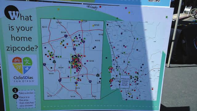
10 Communication and Reach What does it measure? Measures of communication and reach show how participants heard about Open Streets and where they live in relation to the event. Why measure it? A example communication tool for Open Streets participants. Data from these measures shows the broad reach that Open Streets has on the host neighborhoods and the surrounding area. This information points out the best promotional strategies and can be used to plan media for future events. One method of evaluating communication and reach is the use of interactive posters. A poster-size map of the Open Streets and surrounding area allows participants to place a sticker on their home zipcode. This is a quick and easy way to assess where people travel from to attend the event and how they heard about the event. Since most Open Streets events are geared toward families and children, and kids love stickers, it is a fun and interactive way to collect data. An advertisement for Open Streets events in Ferguson, MO. 7

 and reach or call out to folks as they cycle and walk by The ZIP code map to track participants for a St. Louis Open Streets event.")
11 How do I measure it? Supplies needed: Preferred: ArcGIS or other mapping software; Alternatives: Google Maps or Reach Poster: ZIP codes in city of initiative, with initiative location clearly demarcated on the map Communication Poster: different communication and marketing methods utilized by the event organizers and other possible means by which participants learned of the event Small stickers such as dots or stars Poster stands or volunteers willing and able to hold posters (with solid backing) and reach or call out to folks as they cycle and walk by The ZIP code map to track participants for a St. Louis Open Streets event. An example communication poster from a Ferguson Sunday Parkways event. 8


.")
. You can use ArcGIS, Google Maps, or a similar mapping software to do this. 3. Print and mount final posters.")


12 Making Interactive Posters Work Communication Poster 1. To make the Communication Poster, select promotion strategies that will be assessed on the Communication Poster. Using the template provided on this website, fill in the blanks with the main communication, marketing, social media, and advertising strategies that were used to promote the Open Streets event (see example on p. 8). This list of strategies might differ for each individual event within the same city. For instance, in St. Louis, the following are examples of strategies listed on the poster: Facebook, Twitter, friend or co-worker, school, faith-based organization, Riverfront Times, St. Louis American, neighborhood association, flier or poster. Always include an other catgeory! 2. To make the Reach Poster, make a list of the ZIP codes in the area surrounding Open Streets. Estimate the expected travel distance of participants (e.g. a radius of approximately 15 miles around the event location). After the ZIP codes list is made, create a map that clearly defines ZIP code boundaries, ZIP code labels, major roads and greenspaces, and lines that represent the route of the Open Streets event (see example on p. 8). You can use ArcGIS, Google Maps, or a similar mapping software to do this. 3. Print and mount final posters. Enlarge and print both of the posters. A poster size of 4 x 3 is recommended for the posters. Mount each of the posters on a thick and sturdy poster board. 4. Collect data on Open Streets event day. Set up the posters side-by-side at a hub centrally located within the event route. Staff members or volunteers will approach as many event participants that pass the posters as possible. Each event participant will be asked to use a sticker to locate their home ZIP code and put a sticker on the poster section that shows how they heard about the event. 5. Putting it all together. Count the number of stickers in each ZIP code and communication strategy, and enter them into a spreadsheet. These counts can be used to show community leaders, be compared to previous events and help with future communication and reach strategies. 9


13 Making Interactive Posters Work Other Ideas Instead of posters, another fun way to collect data is to ask participants to make a selection by either taking an item or adding an item. For example, you can have 200 marbles and ask Open Street visitors to take a marble and place it in the decorated coffee can representing their favorite activity. You can also have a can for each activity pre-filled with 100 bouncy balls and have participants take them OUT as their selection. Subtract the remainder left after an event from the number you started with to get the number of participants selecting that activity or communication. Amy Eyler, PhD, records this family s home ZIP code using a poster and stickers. Two examples of interactive posters used during the CicloSDias Open Streets initiative in San Diego. 10

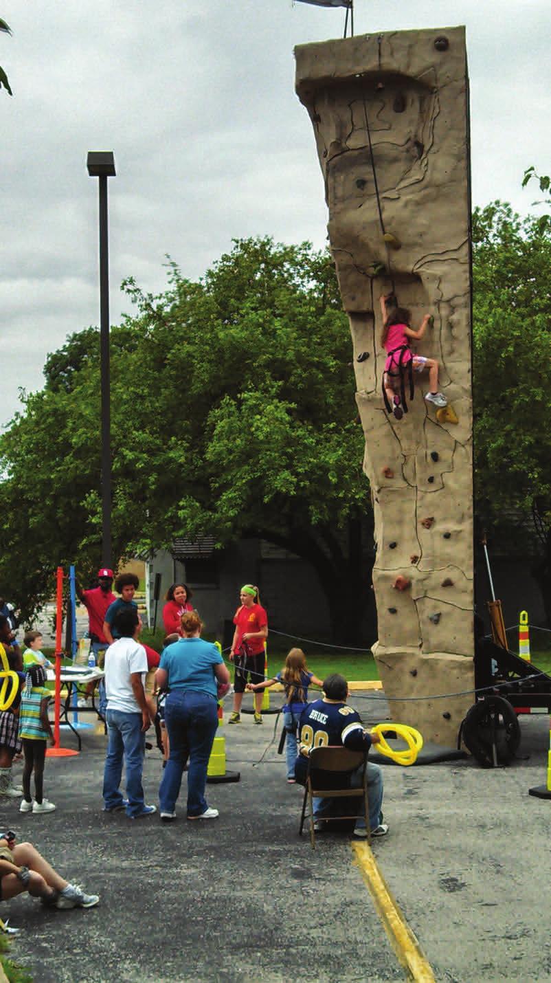
14 Activity Hubs Why Measure it? Most Open Streets initiatives are not open streets alone; they also consist of related healthy activities, music, dancing, and food. Specific examples include basketball shooting contests, yoga and Zumba lessons, guided walking and cycling tours, bounce houses, health literacy information, etc. Our team has termed these related, healthy opportunities, Activity Hubs. Many Open Streets host or sponsor a few to dozens of such opportunities. A successful activity hub will differ depending on type, but in general success would be people participating and enjoying themselves. Activity Hubs are an important aspect of Open Streets as they draw people to the initiative, provide additional healthy activities, and engage participants in fun ways. Activity hubs are important to measure and have a record of the types of activities and participants reactions. Do hubs provide giveaways (e.g. reusable grocery bags, frisbees, pedometers), promote other activities (e.g. yoga classes at their studio), or hand out health information (e.g. healthy recipes)? Such information can be used to promote future Open Streets and market Open Streets to a larger audience. Activity Hubs can also be used to help the flow of Open Streets by getting people to move from one activity to another. This is a crucial piece to Open Streets because physical activity is one of the primary goals; this aspect distinguishes Open Streets from street festivals. What does it measure? This tool measures participation in activity hubs and provides a place to note what the activity hubs are doing and list any potential giveaways. There is also a brief interview guide if you wish to follow-up with organizations or individuals who hosted an activity hub. This provides them the opportunity to tell you what worked and what did not. 11
15 How do I measure it? Supplies needed: Pathway to Measurement for Activity Hubs Tool Clipboards Pencils/Pens Watch Steps on the Pathway to Measurement: Step 1: Select the Activity Hubs to be evaluated. Before the event, depending on resources available and number of evaluators, choose the number of Activity Hubs and the specific Activity Hubs to be observed. For example, select observing activity hubs focused primarily on kids activities or Activity Hubs presented by funding partners. Or if you are able to observe multiple Activity Hubs try to select a variety of different activities: one for kids, one for adults, one dancing, one food-related, etc. Step 2: Complete observation portion of Pathway to Measurement for Activity Hubs Tool. It is recommended that each Activity Hub will be observed for three 15-minute intervals throughout the course of the Open Streets event. One staff member or volunteer is needed to observe each activity hub. For consistency, it is best if the same person observes the same activity hub for each of the three observation periods. The observation entails standing near the Activity Hub and recording observations of activity hub organization staff, activity, participants, or any other interesting aspects of the environment including material distribution (e.g. pamphlets, recipe cards, soccer balls). It is important to obtain the contact information of the Activity Hub organizer for the follow-up interview process. Step 3: Complete follow-up phone interview with each Activity Hub organizer. A team member will call a sample of Activity Hub organizers so they can provide their insight to the successes and challenges of the Activity Hub. A follow-up period of no more than one week after the Open Streets event is recommended. Step 4: Putting it all together. At least two team members will read the observations and qualitative comments from the follow-up interview. The team will regroup and use the qualitative data to drive Activity Hub strategy (e.g. diversity, location, marketing, etc.) for future initiatives. This strategy is dependent on the Open Streets team s priorities and its definition of success (number of people engaged, if pamphlets were handed out, if people were participating and doing yoga rather than standing around, etc.) 12
16 Pathway to Measurement For Activity Hubs PATHWAY TO MEASUREMENT FOR ACTIVITY HUBS TOOL The pathway to measurement for the Activity Hub will be a combination of observation and follow-up phone calls on perception of success. The Activity Hubs may differ based on sponsor organization and related activities, but the basis of the observation will be the same. The following example sheets will be used to record information. Template forms are available online on this website. Event name: Open Streets St. Louis Location: Downtown St. Louis Date: 11/23/2013 Observer Name: Chris Thompson Name of Organization/Activity Hub: Urban Breath Yoga Studio Location of Activity Hub: 8th Street & Clark Ave. Describe any tracking or material distribution at hub. a. Will the organization record participant information? If yes, how? Yes. They have a sign-up sheet for names and s. b. Does the organization distribute flyers or other promotional materials? (If yes, will there be a before-after count of number distributed?) There are flyers available on a small table, but they are not given out to participants. c. Are there any other unique data collection aspects at the hub? If yes, please describe. Owners of studio are also keeping a tally of participants. Observation of Location: Please describe the location of the hub. (Where is it situated? What does the hub consist of? What buildings are nearby? What is the condition of the street? ) The hub is on the northwest corner of the street. They are using street for yoga classes but not blocking other walkers and cyclists. There is a small market and bank nearby. Street is in good condition. 13
17 Activity Hub Observation Table Directions: Stand near the Activity Hub. For three, 15-minute periods in the table below, record observations of organization staff, activity, participants, or any other interesting aspects in the surrounding environment. [10:00 10:15 am] 5-6 people were hesitant to participate in the yoga session at first. Mostly stood around and watched. Then two or three participants who knew the instructor came and encouraged them to participate. Those standing around then joined and seemed to enjoy the activity. [12:30 12:45 pm] There were no participants during this time. A family with two small kids approached the yoga area to get more information about the studio, but did not want to try it in the space available. [2:45-3:00 pm] This period covered the last part of a yoga session which focused on relaxation. 12 participants all laid down on yoga mats and practiced deep breathing. 14
18 Follow-Up Interview For Activity Hubs The following is an example of a follow-up interview in order to gauge the success of the Activity Hub. Interview templates will be available online on this website. Follow up information and questions. Record name and phone number of a person who can answer questions on the perception of the success of the hub in a follow up interview. Name: Rebecca Wooldridge Title: Yoga Instructor Phone number: (314) rwool@urbanbreathyoga.com Scheduled time for follow-up call: Tuesday, Nov. 26 at 11:30am Follow-up Questions: (please record answers) 1. What is your general sense of Open Streets on 11/23/12? I thought the event was so cool! It was great to see a bunch of people trying yoga who maybe wouldn t normally. I loved seeing participants who had never been to our studio before enjoy it! 2. Describe your activity hub during Open Streets. Probe: What activity was going on? Were there lots of people? We had quite a few participants. Some would only stay for a few poses, some for the entire 30 minute session that I was leading. I tried to keep it basic so we could appeal to lots of people. 3. Do you think your Activity Hub was successful? Why or Why not? (Probe: How do you define success?) I think our activity was very successful. People seemed to be smiling the whole time and loved being able to do it with their family members or friends. We had a lot of people ask for more information about our studio and sign up for our list. 15

19 Follow-Up Interview For Activity Hubs Follow-up Questions (Continued): 4. What could be done to make activity hubs better for future events? I think activity hubs would be better if we had some sort of tent/shade covering. It was a very sunny day and it was hard for people to see me and follow along in the sunlight. 5. Would your organization be interested in hosting activity hubs for future Open Streets Events? We would definitely be interested! We love doing events like this that reach the St. Louis community and get people interested in living a happier, healthier life. One of the busy Activity Hubs at the Minneapolis/St. Paul Open Streets in summer

20 Participant Count What does it measure? Count and estimate participants, their demographics (gender, adult or child, race), and their primary Open Streets activity during the initiative. Why measure it? An accurate participant count captures the impact of the Open Streets initiative and how participants are distributed throughout the event. The tool can be used to make comparisons with other initiatives and programs within the same city or other cities with similar programming. Furthermore, a participant count can be used to advocate the impact and reach of Open Streets. Along with a proper costbenefit analysis, it can also drive strategy during the organization process of future events. For example, by learning the proportion of children and adults during Open Streets, organizers can plan different Activity Hubs and activities that are more attractive to match city demographics. How do I measure it? Supplies needed: Participant Count Observation Pathway to Measurement Tool Pencils Clipboards Watch Spreadsheet Participants at the Ferguson, Missouri, Sunday Parkways event in June
21 Participant Count Steps on the Measurement Pathway: Step 1: Select the observation points. The number and location of observation points will depend on the number of volunteers and staff members as well as the distance of Open Streets. Two observers per observation point are necessary for this Participant Count tool. Therefore, the number of observation points will be half of the number of available observers. To determine the location of the observation points, divide the route length of the Open Streets event by half of the number of observers available for this tool. Then, distribute two observers to observation points with the calculated distance (using Google Maps) in between each team. Step 2: Define the observation time period. Three, 15-minute observation periods are recommended. It is also suggested that these observation time periods are an hour apart (i.e. 9:45 a.m. to 10:00 a.m., 10:45 a.m. to 11:00 a.m., and 11:45 a.m. to 12:00 p.m.). Step 3: Conduct the participant count observations. The two observers at each observation point will count and record quantitative observations of different types of participants. Age, gender, and race are based on the observers best approximation. Observers should also write the exact cross-streets on the tally sheet. During each time period, observers will record the following: Observer #1: The number of adult (18+) participants by gender, who are walking, cycling, or skating. Race/ethnicity can be included as well, but this can be very difficult to determine on observation alone. Observer #2: The number of child (<18) participants by gender, who are walking, cycling, skating, or being pushed. Race/ethnicity can be included as well, but this can be very difficult to determine on observation alone. Observer #1 & 2: General qualitative observations about the participants including social groups (number of people in groups, combination of children/adults), the interaction among the different forms of activity (e.g. are cyclists staying on one side of the road, where are most pedestrians in relation to other active participants), are people carrying things (e.g. give-a-ways). Record of the environment including merchants, attractiveness, and presence/absence of sidewalks. 18

22 Participant Count Step 4: Data input. Input the count data collected on Participant Count tally sheets into a spreadsheet following Open Streets. Adult and child counts, and observation points should be separated. An example Participant Count Spreadsheet is available on this website. It displays cell numbers and formulas. Step 5: Data analysis: Summation of observed participant counts. Add up all of the observed participant counts on the spreadsheet using formulas. The spreadsheet formulas depend on the number of observation locations used. Step 6: Putting it all together: Estimation of total participants. Multiply the number of participants observed by the speeds of activities using the formulas in the available Participant Count spreadsheet. The spreadsheet takes into account the distance between observation points and general speed of participant based on activity (cycling, walking, skating). Please note: These speeds and activities are based on Bogota's Ciclovía. We believe this underestimates total participation in most US Open Streets due to the presence of many Activity Hubs resulting in families walking shorter distances and instead participating in Activity Hubs. Surveyors at CicloSDias San Diego estimate their participants. 19
23 Participant Count [9:15 9:30 am] Adult Walkers Male Adult Walkers Female Adult Cyclists Male Adult Cyclists Female Adult Skaters Male Adult Skaters Female Adult Other Male Adult Other Female WHITE/ CAUCASIAN AFRICAN AMERICAN HISPANIC ASIAN OTHER/NOT ABLE TO DETERMINE This example Participant Count Tally Sheet can be used to keep track of adult/child counts, participants race/ethnicity and activities during Open Streets. 20


24 21
25 Observation Materials PARTICIPANT COUNT OBSERVATION PATHWAY TO MEASUREMENT TOOL Protocol: The following example sheets will be used to record information. Template forms are available on this website. November 23, 2013, Downtown St. Louis Open Streets Observations will take place at three points along the route. There will be 3 observation periods of 15 minutes each. [Identify the 3 separate time periods. For example; 9:45-10:00, 10:45-11:00, 11:45-12:00] The two observers per location will record: Observer #1: The number of adult (18+) participants by gender, who are walking, cycling, or skating. Observer #2: The number of child (<18) participants by gender, who are walking, cycling, or being pushed/carried. skating, Observer #1 & 2: General observations about the participants including social groups (number of people in groups, combination of children/adults), the interaction among the different forms of activity (e.g. are cyclists staying on one side of the road, where are most pedestrians in relation to other active participants), are people carrying things (e.g. giveaways). Make a record of the environment including merchants, attractiveness, presence/absence of sidewalks. Age and gender are your best approximation. Be sure to write exact cross-street on the tally sheet. Location #1: Grand & 14th Street Location #2: Directly across the street from Qdoba on the corner of 15th & Jefferson Location #3: The four-way stop at Chouteau & 17th Street OBESERVER #1: Adults and Activity Observer s Name: Julie Nichols During the times listed, please tally the participants in the appropriate categories. Count people as they go by the line of sight directly in front of you. For example, stand on the south side of the street and pick a spot directly across from you on the north side of the street (fire hydrant, doorway, etc.) Make a tally mark for each person that crosses this imaginary line during the 15-minute time frame. 22
26 Observation Materials Observation Location: Grand & 14th street [9:15 9:30 am] Walkers Male Walkers Female Cyclists Male Cyclists Female Skaters Male Skaters Female Other Male Other Female WHITE/ CAUCASIAN AFRICAN AMERICAN HISPANIC ASIAN OTHER/NOT ABLE TO DETERMINE Repeat this same table for Time #2 and Time #3. 23
27 Observation Materials Observer #2 Children (<18) Observer s Name: William Blatz During the times listed, please tally the participants in the appropriate categories. Count people as they go by the line of sight directly in front of you. For example, stand on the south side of the street and pick a spot directly across from you on the north side of the street (fire hydrant, doorway, etc.) Make a tally mark for each person that crosses this imaginary line during the 15-minute time frame. Observation Location: Across the street from Qdoba at 15th & Jefferson [11:45a 12:00p] Walkers Male Walkers Female Cyclists Male Cyclists Female Skaters Male Skaters Female Strollers/ Carrried Other WHITE/ CAUCASIAN AFRICAN AMERICAN HISPANIC ASIAN OTHER/UNABLE TO DETERMINE Repeat this same table for Time #2 and Time #3. 24
28 Observation Materials Observer #1 & #2 Qualitative Evaluations Observer s Name: Julie Nichols Observation Location: Grand & 14th street Answer the following questions for each of the time periods for study. Describe the overall environment in your viewscape including Activity Hubs, merchants, trees, benches, sidewalks, etc. For example: Three open stores, two closed stores. Stores appear to have light traffic. Both sides of street tree-lined. Two benches on street, with person turnover every five minutes. Sidewalks are in good condition. The Activity Hub, hula hooping, has had a steady stream of participants. There are cars parked on street. The south side of street is shaded and the north is in sun. Most people keeping to the sunny-side. During the 45 minutes between direct observation times, please walk around and enjoy the Open Streets. As you do this, feel free to continue note-taking on an additional sheet of paper and please take digital photographs of the event. If you think of any items that should be measured in addition to the ones listed above, please suggest these here. Finally, if you are near an Activity Hub or a natural break in the Open Streets (intersection with through traffic) and have time to walk to this area please do so and note the interactions and numbers around these designated activities. We very much appreciate your participation and input into this evaluation. Observation Time: [9:15-9:30 am] Describe the groups of people in your line of sight. Are they traveling in groups? What is the make up of these groups (college students, families, etc.)? How are people doing different types of ac vity interac ng with one another (are there confronta ons between bikers and walkers, accidents, near misses)? Are cycling and ska ng par cipants wearing appropriate safety equipment? There are a couple of larger groups of college-aged women who are walking together. There was a small team of male bike riders and a group of elderly men walking as well. There was almost an accident between a guy on a pogo stick and someone rollerblading. The pogosticker jumped off quickly and the rollerblader swerved to avoid him. Most people seem to be wearing helmets, but the group of female bikers did not have helmets on. 25
29 Observation Materials Describe what people are carrying (grocery bags, water bo les, balls, chairs, picnic baskets, etc.). Es mate the racial composi on during this 15 minutes (75% white, 20% African American, 5% other) No one I saw was carrying anything other than ipods or water bottles. Around 30% were white, 20% were African-American, 15% were Hispanic, 10% Asian, and 25% other /unable to determine. Are people using the street for purposes other than travel? For example, throwing a Frisbee/ football, kicking a soccer ball, si ng in folding chairs, playing board games, having a picnic. How have people ac vated this open space? Are there pets in the streets? On leash? Is there any non permanent signage? Whether for the Open Streets event or to en ce people into stores? Does there appear to be a pa ern of movement? E.g., most people are walking/biking toward baseball game, park, certain store. Is there security? Police (walking or biking), volunteers? Addi onal notes? Everyone at my intersection was just passing through. No one stopped along the way to sit or played anything along the way. There were two dogs on a leash with the group of female walkers. Two of the clothing boutiques along the street had chalkboard signs encouraging people to come in and browse. Most people seem to be heading toward the shopping/restaurant district two blocks away. There was 1 police officer on a bike and 2 Open Streets volunteers. The streets were in pretty rough shape which made it hard for people to use the entire space. They mostly stuck to the right side. Repeat this same table for Observation Time #2 & #3 and for Observer #2 s Observation Times #1, #2, & #3. 26
30 Activity Level (During Open Streets Event) What does it measure? Measures of activity level are used to determine how participants spend their time at Open Streets and how much physical activity participants are receiving (compared to CDC guidelines of 150 minutes per week for adults and 60 minutes per day for children.). Why measure it? A short intercept survey is one of the methods used to assess participant activity level during the Open Streets initiative. Additionally, an interactive poster and Participant Count can be used to allow for a larger sample of participants to quickly inform evaluators on how the community is spending their time at Open Streets. How do I measure it? Supplies needed: Participant Survey Tool (located on pgs of this toolkit) Poster of activity wheel Small stickers Poster stand Consent form (if survey results are being used for academic & dissemination purposes) Response rate form Clipboards Pencils Spreadsheet Note: The activity wheel and the communication methods (how the participant learned of the Open Streets) posters are captured in the same document/poster. Poster Steps on the Pathway to Measurement: Step 1: Create an activity wheel poster. A template is available online on this website. The activity wheel (pie chart) addresses five primary forms of physical activity at Open Streets: walking, jogging, cycling, using another wheeled device (skateboard, wheelchair), and participating in Activity Hubs. Step 2: Print and mount final poster. Print the activity wheel poster. A poster size of 4 wide x 3 high is recommended. Mount each of the posters on a thick and sturdy poster board. Step 3: Collect poster data on Open Streets day. Set up the poster at a hub centrally located within the route. One to two staff members or volunteers (depending on expected attendance and capacity of staff/volunteers) will approach as many event participants (bicyclists, walkers, joggers, etc.) as possible that pass the posters. Each participant will be instructed to use a sticker to indicate their primary activity during the event. Staff/ volunteers can place the sticker for cyclists so they do not have to stop and dismount. Step 4: Putting it all together. Count the number of stickers in each activity on the wheel. These counts can be compared to previous events and be used to inform future activity priorities. 27
31 Participant Survey Steps on the Pathway to Measurement: Step 1: Select questions desired for the survey. It is best to limit the survey to one page to make it quick and improve response rate (the number saying yes!). Step 2: Print a sufficient number of copies of the Participant Survey. Print out copies of the Participant Survey tool depending on the number of surveys the organizers hope to collect or the estimated number of event participants. Step 3: Select survey location sites. Select distinct route segments where the surveyors will collect data. It is necessary to cover the majority of the route with these survey locations. Two surveyors will be assigned to each survey location/segment. Step 4: Collect participant surveys. Be sure to fill in the time and date of each survey. As surveyors walk along their assigned segment, the goal is for each surveyor is to obtain 20 completed surveys during each 2 hour period. The specific protocol for the surveyors is located on the first page of the survey tool (shown on p. 32 of this toolkit). Question 6 (located on pgs of this toolkit) provides information on the activity level of participants and how people spend their time in the Open Streets (and how much time they spend doing those specific activities). Step 5: Putting it all together. Input the survey responses into a spreadsheet. PATHWAY TO MEASUREMENT FOR OPEN STREETS PARTICIPANT SURVEY The purpose of this survey is to understand who is attending Open Streets Initiatives and how they are participating. The survey will take participants about 5 minutes to complete and consists of 32 questions on Open Streets, perceptions of the city, and basic demographics. No names or identifiers are collected with the survey. Two people will be stationed at each of the three survey locations: Location #1: 11th & Pine, outside Starbucks Surveyors: Becky Warren & Shirlie Thomas Survey Sheets: #1-30 Location #2: 8th & Chestnut Surveyors: Stan Alvarez & Cindy Duncan Survey Sheets: #31 60 Location #3: 10th & Walnut Surveyors: Christy Schmitz & Tim Collison Survey Sheets: #
![Participant Survey The protocol is as follows: Surveying will take place between [Give time period and date]. The goal is for each surveyor to obtain 20 completed surveys during the 2 hour period.](/docs-images/74/70503796/images/32-1.jpg "Each survey will take approximately 5 minutes to complete. If you finish early, you can record observations at your survey point or explore the rest of the route and summarize your experience.")
32 Participant Survey The protocol is as follows: Surveying will take place between [Give time period and date]. The goal is for each surveyor to obtain 20 completed surveys during the 2 hour period. Each survey will take approximately 5 minutes to complete. If you finish early, you can record observations at your survey point or explore the rest of the route and summarize your experience. Qualitative sheets will be provided as well. All participants must be at least 18 years of age. Please ask if you are unsure if they are at least 18 years of age (for academic research and consent only). Introduce yourself (name and affiliation). State that you are evaluating Open Streets and that these results will be shared with the city. Indicate that you are not asking for any identifying information. You can give participants the option to be asked the questions (interview) or fill out the survey themselves (self-administered). Clipboards are provided. Offer the project information sheet/consent to them prior to filling it out (they do not have to take these; it is for their information. Again, this is only for academic publishing purposes). To the best extent possible, please approach each person that passes your designated area, not avoiding any persons or only approaching your same gender., age group, or race/ethnicity. If you approach a group of people, only one person should fill out the survey. Please ask the person with the birthdate closest to today to complete the survey. Be sure to thank them for their time even if they refuse. Please keep a tally sheet of people approached and people participating (response rate). 29
33 Open Streets Response Rate Form Event: St. Louis Open Streets Date: 11/23/13 OPEN STREETS RESPONSE RATE FORM RESPONSE CYCLIST WALKER OTHER FEMALE MALE FEMALE MALE FEMALE MALE YES NO 30
34 Participant Survey OPEN STREETS PARTICIPANT SURVEY TALLY SHEET Researcher/Surveyor Name: Becky Warren Location: 11th & Pine, outside Starbucks Persons approached and asked to participate: Persons accepting (should equal 20): ID numbers of surveys and time surveys completed: ID #s: 1-20 Additional Notes (numbers, activities, differences from the first Open Streets, weather etc.): The weather was really cool during this time, so it was hard to get participants to stop and take our survey. We also were in a place that had a biking activity hub, so people did not stop very frequently. 31
35 Participant Survey The example survey featured on pgs is a two-page version of a survey conducted during a St. Louis Open Streets event. Other templates for a shorter, one-page survey and a longer three-page survey are available online on this website. Choose which survey template best fits your evaluation needs. How do I Choose Which Questions to Ask? When designing your survey or modifying an existing template, it is important to choose questions that ask participants for information that is important for your specific Open Streets. Questions that provide information that key stakeholders, Open Streets partners, and future planners can use is key. Topic Area Example Questions Why Ask These Questions? Demographics - What is your home Zip Code? - What is your age? - Which one or more of the following races/ethnicities best describes you? - What is the highest level of education you have received? These questions are asked in order to get a better idea of who is participating in Open Streets. This information can be used to characterize your population for publications or can be used to tailor advertisements or message targeting for future Open Streets events. Time Spent & Activities at Open Streets Feedback on Open Streets - How long do you plan to spend at Open Streets? - How much time have you spent or do you plan to spend doing the following activities? - How much money have you/ your family spent or plan o spending today at Open Streets? - What is the main reason you came to Open Streets today? - What is your main recommendation for improving everyone s experience at Open Streets? - If you could suggest a new route for Open Streets, what would it be? These questions are asked in order to get a better understanding of what people are doing at Open Streets. This information can be used to encourage business community buy-in, plan future Activity Hubs, and discover what about Open Streets worked and what needs to be redesigned. These questions also answer how much physical activity participants are getting. This information can be used to improve future Open Streets events. It can also be used to highlight your successes and incorporate other parts of the city in the future. 32
36 33 Participant Survey
37 Participant Survey 34
38 Cost-Benefit and Business Community Buy-In What does it measure? Measures of money spent, money earned, number of customers, and increased awareness of stores and restaurants. Why measure it? Business buy-in by stores and restaurants along the route and affected by the streets being open to pedestrians, cyclists, and families is essential to the success of Open Streets. The ability to capture and put some numbers behind how Open Streets impacts local businesses, and how much participants spend, will be key to a sustainable initiative. The results from the business and participant surveys can be shared with businesses along the next route or at city council meetings to support the initiative. How do I measure it? A short intercept survey is one of the methods used to capture money spent and awareness of new stores and restaurants by Open Streets participants. Example surveys are available on p Business and restaurant owners should also be engaged with one, or both, of the following surveys. The first, five-question survey is to be conducted in-person two weeks prior the Open Streets and two weeks following Open Streets. It is best to walk the route and capture as many businesses as possible. The second, ten-question survey is to only be given once during the week following Open Streets. Surveys have always been given on Tuesdays due to some businesses being closed on Monday. This also allows the team to prepare the data collection. Supplies needed: Copies of survey Clipboards Information on Open Streets Contact information for surveyor Pens/Pencils All of the Cost-Benefit and Business Community Buy-In materials are courtesy of Susan Zieff and Anoshua Chaudhuri. The following citation can be used to access their work: Zieff SG, Chaudhuri A. Sunday Streets Economic Impact Assessment. San Francisco, CA.: San Francisco Metropolitan Transportation Agency. February


39 Cost-Benefit and Business Community Buy-In Feedback from business owners and financial results: 73% of Open Streets participants spent money at a restaurant or store on the Open Streets route. It's a free event and it brings around 250,000 people into the area over three weekends, so the businesses do benefit. We generally get positive responses. Some of the businesses along the route have become sponsors over the years. Jessica Werwar, Summer Streets NYC 68% of Open Streets participants became aware of a store or restaurant that was new to them. Owners thought it was an incredible opportunity to showcase their businesses and have a chance to increase sales, but also get free advertising from people traveling at walking speeds. They might not have ever noticed the business before if they were just driving by at 30 miles per hour. Colin Harris, Minneapolis Open Streets Images top and bottom left San Francisco Sunday Streets & SanFranciscoFYI.net 36
40 Business Community Surveys These two surveys were created by Susan Zieff, Ph.D., Department of Kinesiology, San Francisco State University. The survey below should be administered before your Open Streets event. The second survey featured on p. 38 should be administered after your Open Streets event. The answers to both the pre and post surveys should be compared to see if Open Streets created an effect on the business community. 37
41 Business Community Surveys 38


42 39 Example Policy Brief


43 Example Policy Brief 40


44 41 Example Policy Brief

45 Example Policy Brief 42
46 Resources, Citations, & Links Resources: OpenStreetsProject.org Ciclovía Manual San Francisco Sunday Streets and CDC Evaluability Annual reports from Portland s Sunday Parkways Active Living Research Selected References: Diaz del Casillo, A. (2010). "Evaluation tools for the Ciclovía Recreativa." Ciclovía Recreativa. Retrieved July 25, 2010 from evaluation.html. Hipp, J. A., A. A. Eyler, et al. (2012). "Target population involvement in urban Ciclovías: A preliminary evaluation of St. Louis Open Streets." Journal of Urban Health. Johnson, R. (2012). Bringing new people to the open street: analysis of a participant intercept survey of CicLAvia attendees. Urban and Regional Planning. Los Angeles, University of California, Los Angeles. Master of Urban and Regional Planning: 83. Montes, F., O. Sarmiento, et al. (2012). "Do health benefits outweigh the costs of mass recreational programs? An economic analysis of four Ciclovía programs." Journal of Urban Health 89 (1): Sarmiento, O., A. Torres, et al. (2010). "The ciclovía-recreativa: a mass-recreational program with public health potential." Journal of Physical Activity and Health 7(S2): S163-S180. Torres, A., O. L. Sarmiento, et al. (2012). "The Ciclovía and Cicloruta programs: promising interventions to promote physical activity and social capital in Bogotá, Colombia." American Journal of Public Health 103(2): e23-e30. Torres, A. D., O. L. Sarmiento, et al. (2009). "Recreational Ciclovías: An urban planning & public health program of the Americas with a Latin flavor: 677: May 28 9:15 AM - 9:30 AM." Medicine & Science in Sports & Exercise 41(5): /1201.mss fd. Zieff SG, Chaudhuri A. Sunday Streets Economic Impact Assessment. San Francisco, CA.: San Francisco Metropolitan Transportation Agency. February Zieff, S., M.-S. Kim, et al. (2013). "A "Ciclovía" in San Francisco: charactersitics and physical activity behavior of Sunday Streets participants." Journal of Physical Activity and Health. Zieff, S. G., J. A. Hipp, et al. (2013). "Ciclovía Initiatives: engaging communities, partners, and policy makers along the route to success." Journal of Public Health Management and Practice 19(3): S74-S /PHH.1090b1013e


47 44
Target population involvement in urban ciclovias: a preliminary evaluation of St. Louis Open Streets
 Washington University in St. Louis Washington University Open Scholarship Brown School Faculty Publications Brown School 2012 Target population involvement in urban ciclovias: a preliminary evaluation
Evaluation of San Diego's First CicloSDias Open Streets Event
 Evaluation of San Diego's First CicloSDias Open Streets Event Funded by a grant from The California Endowment San Diego State University School of Public Affair University of California San Diego Department
Atlanta Streets Alive: A Movement Building a Culture of Health in an Urban Environment
 Atlanta Streets Alive: A Movement Building a Culture of Health in an Urban Environment Andrea Torres, PhD candidate, MPH School of Public Health Georgia State University Ciclovias: A healthy epidemic Bogota,
Safe Routes to School NELLIE STONE JOHNSON COMMUNITY SCHOOL
 December 2010 Safe Routes to School NELLIE STONE JOHNSON COMMUNITY SCHOOL Encouraging walking and biking to school Safe Routes to School: Healthy Kids Focused Students Across the nation, communities are
Encouraging walking & biking in Latino communities
 Encouraging walking & biking in Latino communities Marne Duke, Metro 6/14/2012 Vamonos! Let s explore Cornelius, Forest Grove and Hillsboro Free, community originated maps that encourage walking and biking
METROPOLITAN TRANSPORTATION PLAN OUTREACH: INTERACTIVE MAP SUMMARY REPORT- 10/03/14
 METROPOLITAN TRANSPORTATION PLAN OUTREACH: INTERACTIVE MAP SUMMARY REPORT- 10/03/14 INTRODUCTION This document summarizes the results of the online interactive mapping exercise implemented by MIG for the
QUEEN ELIZABETH SCHOOL PARK AND GLENGARRY PARK USAGE SURVEY RESULTS Integrated Strategic Development- Citizen Services- City of Edmonton
 QUEEN ELIZABETH SCHOOL PARK AND GLENGARRY PARK USAGE SURVEY RESULTS 2016 Integrated Strategic Development- Citizen Services- City of Edmonton Introduction Background and Objectives District Parks are busy,
EXECUTIVE SUMMARY. Vision
 Vision Walking and bicycling in Salt Lake City will be safe, convenient, comfortable, and viable transportation options that connect people to places, foster recreational and economic development opportunities,
Bringing together community and health. Physical Activity and Nutrition Unit Office of Statewide Health Improvement Initiatives
 Bringing together community and health. Physical Activity and Nutrition Unit Office of Statewide Health Improvement Initiatives Physical Activity and Nutrition Unit Office of Statewide Health Improvement
FLETCHER AVENUE PEDESTRIAN AND BICYCLIST BEHAVIOR CHANGE FORMATIVE RESEARCH PROJECT
 FLETCHER AVENUE PEDESTRIAN AND BICYCLIST BEHAVIOR CHANGE FORMATIVE RESEARCH PROJECT EXTENT OF CHANGES IN PEDESTRIAN AND BICYCLIST ATTITUDES AND BEHAVIORS DIRECTLY AFTER A COMPLETE STREETS PROJECT IN FLORIDA
PETITION AND LETTER WRITING BEST PRACTICES
 PETITION AND LETTER WRITING BEST PRACTICES Petitions and campaign letters can be a great way to bring important bicycle and pedestrian policies and projects to the attention of elected officials. They
Southern California Walking/Biking Research And Creative Evaluation
 Southern California Walking/Biking Research And Creative Evaluation Quantitative Research Topline Report December 7, 2015 Background & Objectives The Southern California Association of Governments (SCAG)
Conducting Bicycle and Pedestrian Counts in Your Community: Count Manager Training. MnDOT and MDH Bicycle and Pedestrian Counting Initiative 2015
 Conducting Bicycle and Pedestrian Counts in Your Community: Count Manager Training MnDOT and MDH Bicycle and Pedestrian Counting Initiative 2015 Objectives 1. Understand what the Bike/Ped Count Program
Impacts and opportunities: Results from a discussion of Cycles for Change s work in the Twin Cities metropolitan area
 Cycles for Change Impacts and opportunities: Results from a discussion of Cycles for Change s work in the Twin Cities metropolitan area In 2013, Cycles for Change received funding from the Center for Prevention
Overview. Mission: Santa Cruz Open Streets fosters individual and community health through creative use of public space.
 Overview Mission: Santa Cruz Open Streets fosters individual and community health through creative use of public space. Event Description Open Streets is a free public outdoor active recreation event which
Bicycle Best Practices: Goals and Priorities for Education and Promotion Efforts
 Bicycle Best Practices: s and Priorities for Education and Promotion Efforts The following education and promotion goals were identified by Salt Lake County as high priorities for the region. 1: Teach
City of Novi Non-Motorized Master Plan 2011 Executive Summary
 City of Novi Non-Motorized Master Plan 2011 Executive Summary Prepared by: February 28, 2011 Why Plan? Encouraging healthy, active lifestyles through pathway and sidewalk connectivity has been a focus
Chapter PERFORMANCE MEASURES AND ACCOUNTABILITY. Introduction
 PERFORMANCE MEASURES AND ACCOUNTABILITY Introduction Performance measures are helpful in evaluating the progress being made toward achieving the goals and objectives of the Gateway Bicycle Plan. The Plan
A comprehensive report of Fort Collins first Open Streets event
 A comprehensive report of Fort Collins first Open Streets event Nicholas Heimann, October 2014 FC Bikes Program Intern Colorado School of Public Health Table of Contents Executive Summary... 3 Overview...
Stakeholder Communication and Public Involvement Plan
 Stakeholder Communication and Public Involvement Plan Arkansas Statewide Bicycle and Pedestrian Transportation Plan Plan purpose: The Arkansas State Bicycle and Pedestrian Plan will establish a framework
 Overview Mission: Santa Cruz Open Streets fosters individual and community health through creative use of public space. Event Description Open Streets is a free public outdoor active recreation event which
2017 North Texas Regional Bicycle Opinion Survey
 2017 North Texas Regional Bicycle Opinion Survey Sustainable Development Program Kevin Kokes, AICP Public Meetings April, 2018 North Central Texas Council of Governments MPO for the Dallas-Fort Worth Region
BUILDING THE CASE FOR TRAVEL OPTIONS IN WASHING TON COUNTY. Image: Steve Morgan. Image: Steve Morgan
 BUILDING THE CASE FOR TRAVEL OPTIONS IN WASHING TON COUNTY Image: Steve Morgan Image: Steve Morgan Image: TriMet Image: TriMet WHAT ARE TRAVEL OPTIONS PROGRAMS? Travel options programs encourage residents,
CITY OF VICTORIA. Campaign Plan INSPIRED COMMUNICATIONS
 CITY OF VICTORIA Campaign Plan INSPIRED COMMUNICATIONS AGENDA Preliminary Research Organizational background Communication analysis Situation analysis Research & Big Idea Methods Results Interpretation
Sue Shikaze Health Promoter, HKPR District Health Unit Chair, Haliburton County Communities in Action Committee
 Sue Shikaze Health Promoter, HKPR District Health Unit Chair, Haliburton County Communities in Action Committee Healthy Communities by Design webinar, July 2013 1 Presentation Overview Background Strategies
DENTON BIKE AND PEDESTRIAN COUNT VOLUNTEER TRAINING
 DENTON BIKE AND PEDESTRIAN COUNT VOLUNTEER TRAINING WHY ARE WE DOING THIS? Part of the National Bicycle and Pedestrian Documentation Project Direct response to lack of data for non-motorized transportation
February Funded by NIEHS Grant #P50ES RAND Center for Population Health and Health Disparities
 Urban Use and Physical Activity Deborah Cohen, Thom McKenzie, Amber Sehgal, Stephanie Williamson, Daniela Golinelli, Multi-Cultural Area Health Education Center (MAHEC) Funded by NIEHS Grant #P50ES012383
CML s 91 st Annual Conference June 18 21, 2013 Vail, Colorado. Why a Campaign? Learn More. City of Brush! 6/13/2013
 REVITALI ZE Your Community with LiveWell Colorado s HEAL Cities & Towns Campaign CML s 91 st Annual Conference June 18 21, 2013 Vail, Colorado Vicky Quinlin, Council Member, Brush! Monty Torres, City Administrator,
Physical activity has a number of benefits
 Health Policy Brief September 2018 Walking Among California Adults Susan H. Babey, Joelle Wolstein, and Allison L. Diamant SUMMARY: This policy brief describes two types of walking among California adults:
1999 On-Board Sacramento Regional Transit District Survey
 SACOG-00-009 1999 On-Board Sacramento Regional Transit District Survey June 2000 Sacramento Area Council of Governments 1999 On-Board Sacramento Regional Transit District Survey June 2000 Table of Contents
Open streets initiatives in the U.S. : Closed to traffic, open to physical activity
 Washington University in St. Louis Washington University Open Scholarship Brown School Faculty Publications Brown School -0 Open streets initiatives in the U.S. : Closed to traffic, open to physical activity
NACTO Design Guides Training Program
 NACTO Design Guides Training Program A Guide for Cities 2015 CONTENTS About the Trainings 1 NACTO Certified Trainers 1 How to Bring a Training to Your City 2 Partners and Responsibilities 3 Organizational
2014 Atlanta BeltLine Running Series Sponsorship Packet
 2014 Atlanta BeltLine Running Series Sponsorship Packet A Program of the beltline.org/run Health & Fitness PROGRAMS 2014 Running Series Health & Fitness Activities Online Health Community The 2014 Atlanta
EXCELLENCE. Executive Summary. Destination: 2014 Downtown Detroit Perceptions Survey
 Executive Summary Destination: EXCELLENCE 2014 Downtown Detroit Perceptions Survey Capturing the Voice of Detroit so we can continue to take giant leaps forward. 1 Executive Summary Overall Impressions
Creating a Successful Pedestrian Safety Campaign. St. Paul, MN
 Creating a Successful Pedestrian Safety Campaign St. Paul, MN - 2015-2017 The Problem The Problem A pedestrian or bicyclist is struck by a vehicle every other day in St. Paul (.84 per day) This doesn t
2013 Glendale Bicycle & Pedestrian Count
 + 2013 Glendale Bicycle & Pedestrian Count Prepared by the Los Angeles County Bicycle Coalition based on material from Ryan Snyder Associates and Alta Planning + Design + What to Bring Know your location
FY14 Bicycle Education & Encouragement Campaign Plan
 Year-Round Resources The following resources & programs will be launched by the beginning of the 2013 fall semester, and will be available for the entire year and beyond. Online Resources Develop a new
Chapter 2. Bellingham Bicycle Master Plan Chapter 2: Policies and Actions
 Chapter 2 Bellingham Bicycle Master Plan Chapter 2: Policies and Actions Chapter 2: Policies and Actions The Bicycle Master Plan provides a road map for making bicycling in Bellingham a viable transportation
FMATS Transportation Improvement Program Non-Motorized Project Nomination Form
 Project nominations are accepted from the public and are scored based on the adopted Project Scoring Criteria. These criteria assign weight based on the project s impact on the following: 1. Health and
University of Victoria Campus Cycling Plan Terms of Reference. 1.0 Project Description
 University of Victoria Campus Cycling Plan Terms of Reference 1.0 Project Description The Campus Cycling Plan, a first for the University, will provide a comprehensive and coordinated approach to support
Summary Report: Built Environment, Health and Obesity
 Research and education Built Environment Edmonton Project Summary Report: Built Environment, Health and Obesity Introduction In 2007 the Canadian Institutes of Health Research and the Heart and Stroke
WALK- AND bike-friendly TURLOCK
 WALK- AND bike-friendly TURLOCK Ideas to Encourage Walking and Biking Benefits to the COMMUNITY Get Connected People who walk and bike have many more opportunities for casual interactions with friends
Watch for Me Pedestrian and Bicycle Safety Program: From North Carolina to Connecticut
 Watch for Me Pedestrian and Bicycle Safety Program: From North Carolina to Connecticut Watch for Me NC Watch for Me NC The Watch for Me NC program empowers communities to address pedestrian and bicycle
Vallecito Elementary School. Travel Plan
 Vallecito Elementary School Travel Plan TABLE OF CONTENTS 1. PURPOSE... 1 1.1. SR2S PLANNING, IMPLEMENTATION AND MONITORING... 1 1.2. MARIN COUNTY MEASURE A... 1 2. VALLECITO ELEMENTARY SCHOOL PROFILE...
Bus Livability Grant: The Bus Stop Amenity Survey and Love Your Bus Stop Outreach Campaign
 Washington Metropolitan Area Transit Authority Bus Livability Grant: The Amenity Survey and Love Your Outreach Campaign Riders Advisory Council February 12, 2014 1 Background WMATA received a $1.875 million
Film Guide for Educators. Designing for Safety
 Film Guide for Educators Designing for Safety Designing For Safety Key Concepts Speeding While Driving Speeding is the number one cause of injuries and deaths from driving. The main reasons are because
Ann Arbor Downtown Street Plan
 1 Ann Arbor Downtown Street Plan Public Workshop #1 We know that. 2 Public right-of-way (streets, sidewalks, and alleys) make up 30% of the total District area of downtown. Streets need to provide mobility
Speed Limits Study and Proposal. Public Input Session: 8/14/13
 Speed Limits Study and Proposal Public Input Session: 8/14/13 Why is Decatur a unique place for this project? First Community Transportation Plan in the nation with a Health Impact Assessment. Strong sense
How your business can get the most out of Atlanta Streets Alive
 business involvement How your business can get the most out of Atlanta Streets Alive What is the Atlanta Bicycle Coalition? We are transforming our streets and neighborhoods into livable communities where
Your Cycling Connection
 Your Cycling Connection 1 Cyclists, pedestrians and transit users shop more often and spend more money than those who drive. Personal Annual Income Commuter Cyclists in Metro Vancouver Over $100,000 $70,000-100,000
Section 9. Implementation
 Section 9. Implementation The transportation system is just one of many aspects that must be carefully planned to maintain and enhance the quality of living in Cecil County. The Cecil County Bicycle Plan
Bike Share Social Equity and Inclusion Target Neighborhoods
 Bike Share Social Equity and Inclusion Target Neighborhoods Target Neighborhoods West End/Visitation Park/Academy/Hamilton Heights Wellsgoodfellow/Kingsway West The Ville/Greater Ville Kingsway East/Fountain
2015 Los Angeles Bicycle & Pedestrian Count
 + 2015 Los Angeles Bicycle & Pedestrian Count Prepared by the Los Angeles County Bicycle Coalition based on material from Ryan Snyder Associates and Alta Planning + Design + What to Bring n Know your location
SAFE ROUTES TO SCHOOL
 CITY OF LOS ANGELES WALKING ACTIVITY HANDBOOK LOS ANGELES UNIFIED SCHOOL DISTRICT CITY OF LOS ANGELES DEPARTMENT OF TRANSPORTATION LOS ANGELES CITYWIDE WALK TO SCHOOL ORGANIZER MANUAL SAFE ROUTES TO SCHOOL
What are the Qualities that make Newark a Bicycle Friendly Community? What are aspects that make Newark less Bicycle Friendly?
 What are the Qualities that make Newark a Bicycle Friendly Community? Many stores are within biking distance (1) Lots of bike lanes and new trail Existing bike routes (2) Designated bike lanes on Del ave.
2018 Summer Bike to Work Day Station Host Toolkit
 2018 Summer Bike to Work Day Station Host Toolkit Contents Contact information:... 2 About Bike to Work Day... 3 2018 Bike to Work Day Details... 4 Commitment... 4 Dates to Remember... 5 Station Co-hosts
The Berston Bicycle Club Project
 Michigan Municipal League The Berston Bicycle Club Project Better Communities. Better Michigan. PROJECT DETAILS: NAME: The Berston Bicycle Club Project PROJECT START DATE: May 2012 LOCATION: Flint, Michigan
Introduction. North 12 th Complete Street Project Overview
 Introduction On Wednesday, March 1, 2017, the City of Sacramento, in partnership with Sacramento Regional Transit District and the Sacramento Housing and Redevelopment Agency, hosted a community outreach
Bikeway action plan. Bicycle Friendly Community Workshop March 5, 2007 Rochester, MN
 Bikeway action plan Summary The was held on March 5, 2007 at the Rochester Mayo Civic Center. The workshop was hosted by Rochester-Olmsted County Planning Department in collaboration with the League of
NACTO Designing Cities Conference Project Evaluation: Tools for Measuring Success and Building Support. October 29, 2015
 NACTO Designing Cities Conference Project Evaluation: Tools for Measuring Success and Building Support October 29, 2015 The case for evaluation: Have a social contract with City Council, staff and community
GREY LYNN TOWN CENTRE PEDESTRIAN INTERCEPT SURVEY FINAL REPORT JUNE 2015
 GREY LYNN TOWN CENTRE PEDESTRIAN INTERCEPT SURVEY FINAL REPORT JUNE 2015 Prepared for: Auckland Transport Prepared by: Aleph Limited Table of Contents 1.0 INTRODUCTION... 3 2.0 METHODOLOGY... 4 3.0 RESULTS...
Cascade Bicycle Club Strategic Plan
 The Greater Context Bicycling has become fundamentally important as large-scale currents of change threaten the health, economy and livability of communities throughout the United States and the world
Improving. Advancing. Catalyzing. Sharing. Momentum IN A YEAR OF CHANGE 2012 ANNUAL REPORT
 Improving Advancing Catalyzing Sharing Momentum IN A YEAR OF CHANGE 2012 ANNUAL REPORT The Safe Routes to School National Partnership is advancing safe walking and bicycling to and from schools and in
PROJECT NAME: Bicycle Empowerment Programme (BEP) PROJECT DURATION: 1 July 2015 to 31 March 2016
 PROJECT DURATION: 1 July 2015 to 31 March 2016") PROJECT NAME: Bicycle Empowerment Programme (BEP) PROJECT DURATION: 1 July 2015 to 31 March 2016 Partners: Terres des Hommes / UBUNTU / EURIST Beneficiaries and project members in front of UBUNTU HQ Project
PROJECT NAME: Bicycle Empowerment Programme (BEP) PROJECT DURATION: 1 July 2015 to 31 March 2016 Partners: Terres des Hommes / UBUNTU / EURIST Beneficiaries and project members in front of UBUNTU HQ Project
PARTNERSHIP OPPORTUNITIES
 PARTNERSHIP OPPORTUNITIES 2017 Since 1967, the Illinois Junior Golf Association (IJGA) has achieved success in developing Better People Through Junior Golf by providing a foundation of sportsmanship, integrity,
Sistrunk Corridor DOTMOCRACY SUMMARY
 DOTMOCRACY SUMMARY The TOUCH initiative is a true collaborative working with multi- sector community organizations and agencies to reduce tobacco use and exposure to secondhand smoke, improve access to
Practicing what we preach in POMONA! Daryl Grigsby, Public Works Director, City of Pomona, California
 Practicing what we preach in POMONA! Daryl Grigsby, Public Works Director, City of Pomona, California Who lives in Pomona? 150,000 people: Young average age 26, 34% under 18 years old, and only 6.5% over
Engagement Summary: Round 1
 Engagement Summary: Round 1 June 21, 2018 REPORT FOR: City of Courtenay 830 Cliff Avenue Courtenay, BC V9N 2J7 PREPARED BY: Urban Systems Ltd. 550 1090 Home Street Vancouver, BC V6B 2W9 ALONG WITH: Kathleen
open streets trends & opportunities
 open streets trends & opportunities Promoting activity-friendly communities. This policy brief was developed with support from the Robert Wood Johnson Foundation (Grant ID 72904) Project Manager: Alyssa
YMCA Safety Around Water: A community Based Drowning Prevention Program Lindsay Mondick
 YMCA Safety Around Water: A community Based Drowning Prevention Program Lindsay Mondick Lindsay is the Senior Manager of Aquatics for YMCA of the USA. In her role, she provides thought leadership and strategy
University-Community Partnerships for Environmental Justice: An example from the San Fernando Valley
 University-Community Partnerships for Environmental Justice: An example from the San Fernando Valley Zeynep Toker, Ph.D., Associate Professor, Urban Studies and Planning Department, California State University,
UMPQUA VALLEY BICYCLE TOURISM STUDIO SOUTHERN OREGON WINE INSTITUTE APRIL 5, 2017
 UMPQUA VALLEY BICYCLE TOURISM STUDIO SOUTHERN OREGON WINE INSTITUTE APRIL 5, 2017 TELLING OUR STORIES Who am I and what do I do? Over the past year, a positive highlight from my experience with bicycling
Safe Routes to School
 Safe Routes to School Amy Paxton-Aiken, Center TRT University of North Carolina Chapel Hill, NC and Ian Thomas, Executive Director PedNet Coalition Columbia, MO Housekeeping If you are calling in on a
MARKET/JFK VISION ZERO PILOT PROJECT FEBRUARY 2019 EVALUATION REPORT
 MARKET/JFK VISION ZERO PILOT PROJECT FEBRUARY 2019 EVALUATION REPORT WHY IS THIS PROJECT IMPORTANT? Market Street and JFK Boulevard in Center City are key east-west corridors in the core business district.
Asbury Park City Council Candidate Questionnaire: Complete Streets in Asbury Park
 Asbury Park City Council Candidate Questionnaire: Complete Streets in Asbury Park The following answers were received by the Asbury Park Complete Streets Coalition in response to questions mailed to all
CHAPTER 7.0 IMPLEMENTATION
 CHAPTER 7.0 IMPLEMENTATION Achieving the vision of the Better Streets Plan will rely on the ability to effectively fund, build and maintain improvements, and to sustain improvements over time. CHAPTER
A bicycle map depicts the local bicycle lane network. It also gives recommendations for routes,
 Promotion Give Cycling a Push PROMOTION/ INFORMATION BICYCLE MAPS Overview Bicycle maps are a must have component for promoting cycling. A bicycle map is more than simply a depiction of the local bicycle
Chapter VISION, MISSION, AND GOALS AND OBJECTIVES. Vision. Mission. Goals and Objectives CONNECTING COMMUNITIES ACROSS THE ST.
 VISION, MISSION, AND GOALS AND OBJECTIVES Chapter 3 The Plan s vision, mission, and goals and objectives were developed through a series of interactive exercises with the Citizens Advisory Committee (CAC)
Lawrence Bike Share Feasibility Study
 Lawrence Bike Share Feasibility Study Stakeholder Meeting June 2016 Agenda 1. Project background 2. Bike share overview 3. How can you help? Project Background University of Kansas - KU Yellow bikes(pre
Bike To School Day Resource Guide 2012
 Bike To School Day Resource Guide 2012 TABLE OF CONTENTS Brief History of Bike to School Day... 3 Introduction... 5 Why Bike To School?... 5 Suggested Activities for Bike to School Day... 7 Bike To School
Introduction. Who is WILMAPCO. Why are walkable communities important
 Walkable Community Workshops Round 1 April 2005 SPONSORED BY WILMAPCO AND CCOBH CITY OF NEW CASTLE EDGEMOOR GARDENS CIVIC ASSOCIATION WITH FUNDING BY DELAWARE DEPARTMENT OF TRANSPORTATION AND THE DELAWARE
Developing a Bike/Pedestrian Plan Using ArcInfo and Public Participation Rob Shumowsky, Madison County Council of Governments
 Developing a Bike/Pedestrian Plan Using ArcInfo and Public Participation Rob Shumowsky, Madison County Council of Governments Abstract: The Madison County Council of Governments is creating a bike/pedestrian
Perryville TOD and Greenway Plan
 Perryville TOD and Greenway Plan Greenway Glossary Pathway: A bicycle and pedestrian path separated from motorized vehicular traffic by an open space, barrier or curb. Multi-use paths may be within the
Route User Intercept Survey Report
 Route User Intercept Survey Report Hills Road, Cambridge Fieldwork: October 2016 Report published: December 2016 1 About Sustrans Sustrans makes smarter travel choices possible, desirable and inevitable.
The 2002 Pedestrian Safety Awareness Campaign
 The 2002 Pedestrian Safety Awareness Campaign From the Metropolitan Washington Council of Governments ABOUT THIS REPORT This report describes the 2002 Street Smart Campaign of the Metropolitan Washington
Trail Use in Itasca County
 ACTIVE LIVING FOR ALL Trail Use in Itasca County 2016 Report Get Fit Itasca was founded in 2008 with the goal of engaging community members in making healthy choices and participating in activities that
Safe Routes to School Grant Application Phase I March 2014
 Safe Routes to School Grant Application Phase I March 2014 Page 1 The City of Mission is requesting grant funding to create a Safe Routes to School Plan which will encompass all of the existing elementary
3. Will there be timing mats at the start of the 5K and 10K? Yes. Your time will start once you cross the start line.
 1. Can substitutions to the team roster be made on the day of the event? We will not make any changes to the team s roster on the day of the event. However, should you have any issues with your bibs or
The National Citizen Survey. Bowling Green, KY. Technical Appendices
 The National Citizen Survey Bowling Green, KY Technical Appendices 2014 National Research Center, Inc. Boulder, CO International City/County Management Association Washington, DC Contents Appendix A: Complete
Corpus Christi Metropolitan Transportation Plan Fiscal Year Introduction:
 Introduction: The Safe, Accountable, Flexible, Efficient Transportation Equity Act: A Legacy for Users (SAFETEA-LU) has continued the efforts started through the Intermodal Surface Transportation Efficiency
CHAPTER 3: Vision Statement and Goals
 Davidson Walks & Rolls: Active Transportation Master Plan CHAPTER 3 Contents: Overview Vision Statement Measurable Goals Public Outreach CHAPTER 3: Vision Statement and Goals Overview The vision statement
SRTS Programs That Increase Walking and Bicycling to School
 Getting Results: SRTS Programs That Increase Walking and Bicycling to School SafeRoutes National Center for Safe Routes to School Communities initiate Safe Routes to School (SRTS) programs for a variety
EBOTS Phase 1 Outreach Summary
 EBOTS Phase 1 Outreach Summary Introduction Between August 2013 and November 2013, the Emeryville-Berkeley-Oakland Transit Study (EBOTS) project team conducted a variety of outreach activities to inform
EXHIBIT B. Rodney Wojtanik, Project Manager, Portland Parks & Recreation
 EXHIBIT B TO: FROM: City Council Rodney Wojtanik, Project Manager, Portland Parks & Recreation DATE: June 22, 2005 For additional information on the public outreach process and recommendations for the
The Role of MPOs in Advancing Safe Routes to School through the Transportation Alternatives Program
 The Role of MPOs in Advancing Safe Routes to School through the Transportation Alternatives Program In 2012, Congress made changes to Federal funding for Safe Routes to School that gave some metropolitan
Is St. Louis Ready for a Bike Share System? May 14, 2014 Public Open House
 Is St. Louis Ready for a Bike Share System? May 14, 2014 Public Open House PRESENTATION AGENDA 2 BIKE SHARE How does it work? What are the benefits? Who would use it? Will it be safe? Would it work in
INTRODUCTION Orientation to M.C.A.S.K. MODULE 1
 INTRODUCTION Orientation to M.C.A.S.K. MODULE 1 Presented by Janelle Curtis, Injury Prevention Consultant, MB Healthy Living, Seniors & Consumer Affairs, Michelle Smith, Injury Prevention Coordinator,
Segmentation overview. Audience understanding and targeted messages. Segmentation.
 04 Segmentation 35 36 Segmentation overview. Audience understanding and targeted messages. A key aspect of ensuring insight is actionable is breaking down the student population into subgroups or segments.
STRATEGIC PLAN Mission To unite and strengthen bicycle advocacy, provide education, and work for a more bicycle friendly Minnesota
 2016-2020 STRATEGIC PLAN Mission To unite and strengthen bicycle advocacy, provide education, and work for a more bicycle friendly Minnesota Vision Minnesota is a place where bicycling is easy, safe, and
Suburban Advocacy Skills Building with Maggie Melin
 Suburban Advocacy Skills Building with Maggie Melin Agenda Background Bike Walk Every Town Policy Platform Campaign Action Plan 6 Steps Resources Next Steps Chicagoland s voice for better biking, walking