FAMPO. Fayetteville Area Metropolitan Planning Organization. Bicycle and Pedestrian Element of the 2040 Metropolitan Transportation Plan
|
|
|
- Dora Newman
- 6 years ago
- Views:
Transcription

1 FAMPO Fayetteville Area Metropolitan Planning Organization Bicycle and Pedestrian Element of the 2040 Metropolitan Transportation Plan April 16, 2014 Continuing Comprehensive Cooperative Transportation Planning
2
3 Table of Contents Executive Summary Section 1.0 Section 2.0 Section 3.0 Section 4.0 Section 5.0 Section 6.0 Section 7.0 Introduction Existing Conditions Public Involvement & Input Connectivity Sidewalks Recommendations Project Prioritization For a complete list of prioritized projects and maps covering the entire area, please visit and search for "Bicycle and Pedestrian Connectivity Study-Appendix" under the "Publications" heading
4 This Page Intentionally Left Blank
5 Executive Summary The Fayetteville Area Metropolitan Planning Organization (FAMPO) Bicycle & Pedestrian Connectivity Plan is a comprehensive analysis of opportunities, barriers, and deficiencies in the bicycle and pedestrian transportation network within the FAMPO Study Area. The goal of the Connectivity Study is to identify and prioritize existing and proposed routes, facilities, improvements, and issues which will establish a safe and effective bicycle and pedestrian network. The FAMPO/Cumberland County Study Area covers four counties, eleven municipalities, Fort Bragg Military Reservation, and Pope Field. The Study Area benefits from several existing assets, including the Cape Fear River, an extensive park system, and a steady influx of new residents. While safety concerns for pedestrians and bicyclists are highlighted by accidents at some hazardous locations, FAMPO area residents do engage in significant amounts of walking and bicycling, both for transportation and recreation. Public outreach efforts throughout the study process have revealed a significant desire among the public for accessible bicycle and pedestrian routes and facilities which can offer them safe transportation to employment, shopping, schools, and recreation. Connectivity Study analysis has produced an ambitious area-wide network accounting for almost 791 miles of both planned and existing bicycle and pedestrian facilities. Recommended improvements - aimed at enhancing the safety and connectivity of the network - are in place for nearly 564 miles of routing, and 211 intersections, crossings, and connections. Equally as important, recommendations are made for the prioritization of projects which will enhance the effectiveness of the network. Recommendations for both routes and intersections include such features as bicycle lanes, sidewalks, multi-use trails, crosswalks, pedestrian signals, signage, and barriers aimed at discouraging crossings of the area s busier roadways. In a small number of cases, individual projects will require focused attention and agreement among stakeholders to ensure completion. The proposed network will reach 608 neighborhoods, 82 schools, and 77 parks. The network s ½-mile service area will reach more than 78,000 children, 24,000 seniors, and 268,000 FAMPO area residents. 1
6 This Page Intentionally Left Blank 2
7 1.0 Introduction Bicycle and pedestrian facilities are an important part of an integrated transportation system. They provide connectivity for the region as well as mobility and safety. These facilities can also support tourism and increase opportunities for physical activity by promoting personal health and well-being. As noted in an on-line survey, bicycle riding in the region is primarily done for recreational purposes. Recreational bicycling continues to grow in popularity in the Fayetteville area. Another important use of bicycles is for commuting and other travel purposes. The identification of bike-friendly roadways and routes will make this mode of transportation a safer and more convenient option for travel. Pedestrian facilities such as sidewalks and trails are another important component of the regional transportation system. Respondents to the on-line survey noted that they walk primarily for recreational purposes but would like to be able to walk to various destinations including schools, shopping, and employment centers. The intent of the Study is to develop a network of interconnected bikeway and pedestrian facilities in order to connect neighborhoods and communities with jobs, shopping, schools, and other services. With the introduction of interconnected walking and/or biking routes, the study area can begin to increase safety while reducing the number of vehicles on the roads, with subsequent reductions in traffic congestion, air pollution, and parking demands. Defining Pedestrian and Bicycle Connectivity Pedestrian and bicycle connectivity can be defined as the ability to access origins and destinations through a series of non-motorized routes. Improved connectivity can include: providing a network of continuous sidewalks; connecting stub streets; constructing a multi-use path from a neighborhood to a greenway, trail, or park; providing marked bike lanes; determining available neighborhood connector routes; identifying safe routes for bicycling and walking; or a combination of any of the above. A system of sidewalks and bicycle facilities which connects key origins and destinations provides users with choices: Provide more direct, convenient and safe travel routes for pedestrians and bicyclists; Increase the ability to walk to key destinations (restaurants, shops, schools, parks, churches, community centers, and place of employment); Provide children with an alternative route to school; Improved access to public transit; Transportation alternatives for individuals who may be unable to drive; Provide a stronger sense of community by encouraging people to walk or bike, increasing the opportunity for interaction with neighbors; and Improved quality of life as a result of increased transportation options and healthy commuting choices 3

8 2.0 Existing Conditions The Fayetteville Area Metropolitan Planning Organization (FAMPO) is a regional transportation planning agency with a jurisdiction of over 608 square miles, covering almost all of Cumberland County and small portions of neighboring Hoke, Harnett, and Robeson Counties. Forcasts indicate that the FAMPO Study Area will see moderate growth in the future and must consider how this growth and other population demographics will affect transportation in the short and long term. According to US Census estimates, 9,187 Cumberland County residents walked, rode bicycles, used public transportation, used taxicabs, or rode motorcycles as a primary means of transportation to work in 2009*. The majority of these residents (7,348) walked, and were between the ages of 20 and 44 (*U.S. Census Bureau, 2009 American Community Survey. Further estimates indicate that more than 10% of 1- person households had no vehicle available. Approximately 25% of 3-person households had one or no vehicle available, and more than 50% of 4- person households had two or fewer vehicles available*. Other estimates revealed that 26,387 households out of 117,001 had a reported household income of less than $20,000 and 59% of households earned less than the median family income of $48,394*. In 2009, 16.4% of individuals in Cumberland County reported income below the poverty level (*U.S. Census Bureau, 2009 American Community Survey. These combined factors indicate a significant low-income population, which has a bearing on access to transportation within the FAMPO Planning Area. In the realm of transportation planning, low-income populations are often considered transit-dependent. These populations may not need to depend on transit or motor vehicles, for that matter if reliable pedestrian and bicycle routes offer them access to important destinations such as employment, shopping, schools, or medical care. Quantitative data and transportation behavior (as observed by Study staff) in the FAMPO Study Area indicate that there is a significant need for safe, efficient bicycle and pedestrian connections throughout the region. 2.1 Safety & Accident History Safety is an essential component of a community s bicycle and pedestrian network. It has been said that if you build it, they will come. In this case, it refers to a safe and well-connected travel route. Safe bicycle and pedestrian routes encourage residents to walk or bike to their destinations, either as a means of travel or recreation. Safe facilities will also ensure the health and well-being of walkers and bicyclists who cannot afford the costs associated with owning and operating a motor vehicle as their primary mode of travel. Features which contribute to a safe walking and biking environment include buffered sidewalks and walking paths, high-visibility crosswalks, pedestrian refuges at road crossings, and high-visibility signage for both motorized and non-motorized travelers. 4
9 Bicycle and pedestrian safety is a concern in Cumberland County and the FAMPO study area, as expressed by citizens and as represented by accident data reported by the North Carolina Department of Motor Vehicles. Fayetteville, the most populated municipality in the FAMPO study area, has had the highest number of bike/pedestrian accidents each year, reaching a high of 121 in 2007 (See Table 2.1). The majority of FAMPO s municipalities are on pace to increase the number of reported accidents in Cumberland County Bicycle & Pedestrian Traffic Accidents Jurisdiction * Eastover Fayetteville Hope Mills Spring Lake Stedman Wade Cumberland County *Includes data from January 1, 2010 through July 31, 2010 Table 2.1: Cumberland County Bicycle & Pedestrian Accidents Source: NCDOT Traffic Engineering Department The unincorporated areas of Cumberland County, in particular, have a higher than average rate of accidents involving bicycles and pedestrians. Between 2005 and 2009 Cumberland County averaged 4.8 bicycle or pedestrian accidents per each 50,000 residents. By comparison, Wake County, NC and Durham County, NC averaged 1.6 and 1.7 accidents per 50,000 residents respectively (See Table 2.2). Unincorporated Cumberland County Bicycle & Pedestrian Traffic Accidents Per 50,000 Residents County Cumberland County, NC Population 305, , , , ,207 Bike/Ped Accidents Accidents/50,000 Residents Wake County, NC Population 753, , , , ,214 Bike/Ped Accidents Accidents/50,000 Residents Durham County, NC Population 243, , , , ,706 Bike/Ped Accidents Accidents/50,000 Residents Table 2.2: Cumberland County Bicycle & Pedestrian Accidents Rate Comparison Source: NCDOT Traffic Engineering Department; 2009 U.S. Census Bureau An effective bicycle and pedestrian network utilizes both existing roads or transportation facilities and separated facilities, such as greenways or trails, to safely transport residents. Because a truly effective network cannot rely on separated facilities alone, existing roads must safely accommodate 5
 in the area stand out as")
10 both bicyclists and pedestrians. Although a lack of dedicated bicycle and pedestrian routes contributes to a lack of safety throughout the study area, several major roads (and potential network segments) in the area stand out as being unsafe. In most cases this is due to an inherent conflict between motorists and bicyclist or pedestrians. Too often, these conflicts arise in areas where high traffic volumes and poor safety treatments overlap neighborhoods and corridors with high pedestrian and bicycle activity. The map below highlights roads where multiple bike/pedestrian accidents (2 or more) have been reported between January 2005 and July 2010 (See Map 2.1). Please see the full Cumberland County Bicycle & Pedestrian Accidents Map in Appendix 1.7. Map 2.1: Cumberland County Bicycle & Pedestrian Accidents The roads with the highest accident totals include Bragg Boulevard, Grove Street, Owen Drive, Raeford Road, and Ramsey Street. Several blocks, on these roads and others all within the City of Fayetteville have proven to be particularly dangerous for bicyclists and pedestrians. These blocks include: Grove Street, B St to Eastern Blvd 9 incidents Grove Street, Ann St to B St 8 incidents Yadkin Road, Horseshoe Rd to Santa Fe Dr 6 incidents Ramsey Street, Country Club Rd to Longview Dr 5 incidents Person Street, Green St to N/S Cool Springs St 5 incidents Owen Drive, Village Dr to Nato Rd 5 incidents Coventry Road, Ireland Dr to Odom Dr 5 incidents Bragg Boulevard, Mike St to Swain St 5 incidents 6
11 2.2 Existing Plans FAMPO, Cumberland County, and individual municipalities within the FAMPO region have worked diligently for more than ten years on planning initiatives within the study area. These planning initiatives include land use plans, transportation studies, economic development studies, and area master plans which include recommendations for enhancing bicycle and pedestrian safety and connectivity in the region. A major component of the plan includes researching these previous plans and studies, and groundtruthing them to determine what recommendations have been implemented, what improvements are programmed and funded, and what improvements are still on the horizon. Of miles of applicable facilities identified in previous plans, 51.4 miles have been completed, partially completed, or were existing at the time of plan completion.* Another essential outcome from the review of existing and previous plans is that we learn where FAMPO partner agencies can capitalize on future investments in infrastructure and improvements. Plans such as the Raeford Road Corridor Study (2010) and Shaw Heights Land Use Plan (2008) detail specific improvements for Raeford Road and the Shaw Heights neighborhood, respectively. Where applicable, these improvements have been taken into account or incorporated into recommendations emerging from the Connectivity Study. The following documents were reviewed in advance of field work associated with the Connectivity Study. Map 2.2, below, is an excerpt from the Existing Plans Inventory & Ground-Truthing Map, which indicates the geographic location and overall status of compiled recommendations emerging from these plans. Only facilities which were proposed at the time of the respective plan are included in the mapping. See Appendix 1.6 for full Ground-Truthing maps. Raeford Road Corridor Study (2010) Cumberland County Land Use Policies Plan (2009) FAMPO Bicycle & Pedestrian Plan (2009) Fayetteville Sustainability Master Plan (2009) Fort Bragg Comprehensive Transportation Systems Plan Alternative Transportation Study (2009)* Multi-Modal Congestion Management Plan Town of Spring Lake (2009) Vision Northeast, Cumberland County (2009) 2030 Growth Vision Plan Growth Factors Analysis (2008) 2030 Growth Vision Plan Policies & Actions (2008) Shaw Heights Land Use Plan (2008) City of Fayetteville Land Use & Economic Development Plan: Murchison Road Corridor (2008) Fayetteville Cumberland Parks & Recreation Master Plan (2006) Wade Study Area Detailed Land Use Plan (2003) North Fayetteville Area Plan (2002) Spring Lake Area Detailed Land Use Plan (2002) Fayetteville Cumberland Parks & Recreation Master Facility Plan Cumberland County 2010 Land Use Plan (1996) *Staff does not have access to Fort Bragg, Pope Airfield, or Simmons Army Airfield on-base facilities. Ground-truthing was not conducted at these locations. 7


12 Map 2.2: Existing Plans Inventory & Ground-Truthing 8

13 2.3 Existing Community Assets Parks There are an abundance of parks within the FAMPO study area. Fayetteville-Cumberland Parks & Recreation currently maintains more than 100 regional parks, community parks, neighborhood parks, linear parks, school parks, mini parks, and special use facilities. Additional parks within the study area include Carvers Creek State Park, Hoke and Harnett County parks, and recreational facilities internal to Fort Bragg. Because of their recreational nature, parks represent important destinations for bike and pedestrian travel. Children and young adults (many of whom do not have access to motor vehicles) are particularly likely to travel to parks, either by foot or bicycle. Humphries Memorial Park, Falcon Schools Of the 92 schools within the FAMPO study area, 85 are in the Cumberland County School System. Five are located in Harnett County and the remaining two are located in Hoke County. Schools are an essential component of any community and have significant impacts on neighborhood character. Both municipalities and families center many housing, transportation, and recreation decisions around the presence of school facilities. Unlike many community destinations such as grocery stores, employment centers, and entertainment hubs, public schools are the responsibility of local governments (counties and cities). It falls to these local governments to ensure the safety of children who travel to and from school. To this end, accommodating safe pedestrian and bicycle travel to and from schools is a significant goal for many communities. As is the case with parks, pedestrian or bicycle travel is often the sole means of travel for students who are not driven by family members and do not ride the bus. Thinking proactively, Cumberland County Schools has considered methods of ensuring safe travel, including federal Safe Routes to School funding for appropriate safety investments. Please see the Safe Routes to School section of this document (Page 27) for an in-depth discussion of Safe Routes to School and efforts associated with the Bicycle and Pedestrian Connectivity Study. Transit Stops Transit is very important in providing mobility and access to residents of any community. Many residents choose not to drive, are physically unable to drive, or choose not to budget money for private transportation. Like bicycle and pedestrian facilities, transit service allows these residents and others to reach important community destinations. 9


14 Transit often comes in the form of a bus, streetcar, or rail system, and provides transportation service to destinations throughout a community. A significant portion of the FAMPO area Fayetteville and Spring Lake is currently served by the bus transit. Connecting transit stops with safe bicycle and pedestrian routes effectively expands the number and range of destinations for residents. Trails Trails are excellent transportation and recreation facilities for both bicycles and pedestrians. They are typically separate from roadway facilities and are designed to be inaccessible to motor vehicles. Generally speaking, trails can be either natural surface or paved, and are typically 5-10 feet in width. Because they are separate from roadway facilities, they can be routed directly from destination to destination and designed to provide bike and pedestrian access to specific locations. Due to their safety and ease of use, trails are the preferred transportation facility for pedestrians and bicyclists with less experience. Rockfish Park, Hope Mills There are several well-designed trail facilities, both existing and planned, within the FAMPO study area. A few notable trails include the Cape Fear River Trail in Fayetteville, Rockfish Park Trail in Hope Mills, the All-American Trail, running southwest from Fort Bragg through Hoke County, and planned Linden Oaks Spring Lake Trail, extending from Fort Bragg and Spring Lake into Harnett County. Many trails can be found in or around parks. Fayetteville s Cross Creek Linear Park, for example, will eventually connect with planned facilities such as the Blount Creek Greenway and Cross Creek Greenway to form an interconnected trail system which will serve many residents. The continuing goal of Fayetteville-Cumberland Parks & Recreation is to establish a county-wide greenway system. Sidewalks The availability and condition of sidewalks in the FAMPO study area varies greatly from location to location. Ground-truthing reveals that while sidewalks are plentiful in areas such as downtown Fayetteville or even nearby areas like the Haymount Neighborhood of Fayetteville, it is less available in more suburban areas and neighboring municipalities. Responses to the on-line survey consistently indicated that areas with extensive interconnected sidewalks and safe crossings were seen as preferred, walkable areas. Hay Street, Fayetteville 10


15 Often, where sidewalks are present it is available only on one side of the road. This effectively makes sidewalks inaccessible for some, or forces bicyclists and pedestrians to cross busy streets often without the aid of safe crossing treatments to reach the sidewalk. Additionally, in many areas sidewalks can best be described as intermittently present. In these locations sidewalk construction has been left to private developers on a case-by-case basis, and only within the frontage of individual parcels. This makes for a haphazard and disjointed sidewalk system. Intermittent Sidewalk - N Bragg Blvd, Spring Lake Another issue which can determine the effectiveness of sidewalks is obstructions within existing sidewalks. Potential obstructions can range from large cracks and holes due to poor maintenance, to mailboxes, to power poles. Obstructions pose both a safety hazard as well as an access barrier to physically disabled users. Please reference the Sidewalk Ordinances section of the Study (Section 5.0) for a detailed discussion of sidewalk requirements which continually shape the availability of sidewalks in the region. Sidewalk Obstruction Rosehill Road, Fayetteville 11
16 3.0 Public Involvement & Input 3.1 Public Involvement To assist in the process of determining destinations, safe and challenging roadways to bike and walk, connected neighborhoods, desired connections, and areas in need of sidewalks; FAMPO convened a Steering Committee and an Interjurisdictional Workgroup. Over the course of six months, the Steering Committee met five times and the Interjurisdictional Workgroup met once to offer guidance and local area expertise to the design team. Bicycle and Pedestrian Steering Committee Membership Rob Anderson, Fayetteville Planning Department Kevin Berry, Citizen Dr. Jeff Brooks, Citizen Representative, Chairman, FAMPO Bike & Pedestrian Committee Maurizia Chapman, FAMPO Rosann Christian, FAST Will Denning, Cumberland County Planning Department Mike Gibson, Fayetteville Cumberland County Parks & Recreation Department Chad Ham, Public Works Commission Craig Harmon, Fayetteville Planning Department Sandy Hawley, Citizen Rick Heicksen, FAMPO Karen Hilton, Fayetteville Planning Department Lee Jernigan, NCDOT Division 6 Brenda Johnson, Sustainable Sandhills Colby Lambert, Cooperative Extension Service Mark Locklear, Harnett County Planning Department Julia Love, Citizen/Fort Bragg Environmental Bobby McCormick, FAMPO Monita McLaurin, NC Department of Commerce, Div. of Community Assistance Bob Miarer, CAC Chair, Cross Creek Cycle Club Jon Parsons, Sustainable Sandhills Michaela Penix, Cumberland County Health Department Neil Perry, City of Fayetteville Traffic Services Anthony Ramsey, Fayetteville Cumberland County Parks & Recreation Department Janet Robertson, Lumber River RPO Victor Sharpe, Fayetteville Community Development Department Tim Shea, Fort Bragg Transportation Joan Shults, Citizen Joel Strickland, Mid-Carolina RPO Darius Sturdivant, NCDOT Transportation Planning Branch Rusty Thompson, City of Fayetteville Traffic Engineer Mark Whitley, Cumberland County Schools Dr. Paul Wilson, Citizen Charles Young, Fort Bragg Transportation Interjurisdictional Workgroup Randy Beeman, Town of Hope Mills Harvey Cain, Town of Stedman Maurizia Chapman, FAMPO Will Denning, Cumberland County Planning Department Karen Hilton, Fayetteville Planning Department Tom Lloyd, Cumberland County Planning Department Mark Locklear, Harnett County Planning Department Bobby McCormick, FAMPO Anthony Ramsey, City of Fayetteville Parks & Recreation Department Matt Rooney, Cumberland County Planning Department Patti Speicher, Cumberland County Planning Department Joel Strickland, Mid-Carolina RPO Denise Sykes, Cumberland County Planning Department 12
17 In addition to working with the Steering Committee and the Inter-jurisdictional Workgroup, study presentations were given to the Transportation Advisory Committee, Citizens Advisory Committee, and the Technical Coordinating Committee. Public Involvement Program The public involvement program for this project included a series of public meetings and on-line surveys. The first-round of public meetings comprised five meetings in locations throughout the FAMPO region: Stedman Recreation Center, Stedman, NC Smith Recreation Center, Fayetteville, NC Spring Lake Community Center, Spring Lake, NC Hope Mills Recreation Center, Hope Mills, NC Methodist University, Fayetteville, NC During these meetings, attendees were asked to work with members of the design team to identify roadways that were safe to walk and bike; areas that were not safe to walk and bike; and destinations that needed connections to make accessible via walking and biking. Despite a concerted publicity and notification effort, 56 people attended the first round of meetings. In an effort to bolster public participation, two on-line surveys were developed with over 500 respondents. (See Appendix 5 for Public Meeting maps as well as survey results). In an effort to reach a broader audience and entice greater public participation, the study was presented as part of the Fayetteville Bikes and Walks event held in conjunction with 4 th Friday in downtown Fayetteville. Groups participating with FAMPO to promote bicycling and walking included: Cumberland County Health Department, City of Fayetteville Sidewalk Program, Fayetteville/Cumberland County Parks & Recreation, and the Cross Creek Cycling Club. Events throughout the evening include bicycle training demonstrations, a children s art activity, free bicycle helmets, and refreshments. Over 400 participated in the event. 13


18 3.2 Public Meetings Public meetings are essential to involving community residents on a personal level, and generating ideas and solutions specific to a community, or a region like FAMPO. The public meetings aided Connectivity Study staff in determining where connectivity could be maximized using existing assets such as sidewalks, trails, or recreational locations. The interactive process allowed participants to mark on maps and note both positive and negative connectivity issues such as access to shopping hubs, hazardous intersections, and bike-able roads. Map 3.1 below is an excerpt from the Hope Mills Recreation Center public meeting map. Map 3.1: Public Meeting Map Excerpt 3.3 On-line Survey On-line surveys are an excellent tool for gathering input from many respondents, quantifying and comparing those responses, and receiving personalized responses. Two on-line surveys were designed for the Connectivity Study to gather input from FAMPO residents on current and future bicycle and pedestrian issues: Survey 1 contained a total of twelve (12) questions aimed at understanding existing conditions, current demand for walk-ability and bike-ability, and specific barriers to connectivity.* 421 residents responded to this survey. Questions were distributed into 5 categories: 1. Tell Us About Yourself 2. Tell Us About Your Walking and Biking Habits 3. Tell Us What You Think About the State of Biking and Walking in Your Area 4. Finding Routes That Work 5. Your Comments and Next Steps 14

19 Figure 3.1 Figure 3.1, above, illustrates the latent demand for a safe, efficient bicycle and pedestrian network in the FAMPO region. Online survey responses to direct current and desired activity questions serve as the basis for this latent demand. Survey 2 contained a total of ten questions aimed at understanding the most appropriate and desirable routes for bicycle and pedestrian traffic in the study area.* 128 residents responded to this survey. Examples of questions include: 1. Please name the streets in your neighborhood that you would recommend for walking and biking. 2. Which intersections do you feel could benefit from improvements? 3. Where would you like to be able to walk or ride your bike to from your neighborhood? *Full survey results can be found in Appendix


20 3.4 Public Input Feedback from the public meetings and on-line surveys is key in identifying routes, intersections, and facilities which need to be studied for the purposes of improving connectivity. Public-Identified Dangerous Streets Over the course of an in-depth public outreach effort, FAMPO area residents identified many factors which inhibit or discourage walking and biking throughout the study area. Most significant among these factors were area roads perceived by the public to be not safe. On-line survey respondents identified a number of roads in the area which they feel are currently unsafe and would likely not use for walking and biking (See Figure 3.2). Figure 3.2 The five streets FAMPO residents most frequently identify as unsafe are Bragg Boulevard, Yadkin Road, Murchison Road, Skibo Road, and Ramsey Street. These streets (and many like them, on both a national and local scale) share several characteristics which make them hazardous for walkers and bicyclists, and discourage their use for non-motorized travel: 16


21 Bragg Boulevard, Fayetteville Murchison Road, Fayetteville Non-existent, disconnected, or sparse sidewalks and bike lanes No natural barrier between vehicle travel lanes and sidewalks High vehicle speeds Non-existent or barely visible pedestrian/bicycle crossings Non-existent or barely visible signage alerting drivers to the presence of pedestrians/bicycles Excessive number of driveways and curb-cuts along potential walking/bicycling routes Obstructions such as utility poles or mailboxes along potential walking/bicycling routes Lack of pedestrian-scale development along road corridor Lack of pedestrian-friendly land uses along road corridor The above characteristics are often the result of deficiencies in planning, design, development regulations and incentives, or education. The 2009 FAMPO Bicycle & Pedestrian Plan identified several deficiencies within the FAMPO planning area which contribute to an unsafe environment for both bicyclists and pedestrians. These deficiencies include: Lack of completed designated bike routes Lack of bike and pedestrian facilities (sidewalks, trails, paths, out-side lanes) Lack of bicycle and pedestrian signs and markings Lack of parking facilities for bikes Lack of parking restrictions for motorist Lack of law enforcement Lack of control signals at intersections Lack of safe crosswalks, refuge islands, and curb ramps Lack of traffic calming measures Lack of accommodations between transit stops Lack of overpasses and underpasses Lack of education 17


22 Public-Identified Dangerous Intersections Roadway intersections are a significant component of a safe bicycle and pedestrian network. From a connectivity perspective, intersections link sidewalks and on-road bicycle facilities to one another. Welldesigned intersections provide users with options regarding where to go and what mode of transport may be most appropriate. From a safety perspective, intersections are the primary point of contact between motor vehicles, bicycles and pedestrians. Absent of safety treatments, intersections also present ample opportunity for conflicts and crashes. Well-designed intersections limit these opportunities for conflict between travel modes. Hull Road & Devers Street: High-visibility, zebra-striped crosswalks and pedestrian crossing signals in all directions, combined with relatively short crossing distances, make this a very bicycleand pedestrian-friendly intersection. On-line survey respondents and public meeting attendees identified a number of intersections within the FAMPO Study Area which they feel are dangerous or could benefit from improvements. Intersections which were referenced multiple times include: Bragg Blvd & Spring Ave Country Club Dr & Rosehill Rd Cliffdale Rd & Rim Rd Cliffdale Rd & Morganton Rd Cliffdale Rd & Reilly Rd Morganton Rd & Northview Rd Morganton Rd & McPherson Church Rd Owen Dr & Village Dr Rockfish Rd & Camden Dr Rockfish Rd & Golfview Dr Skibo Rd & Yadkin Rd Village Drive & Owen Drive: Despite sidewalk along Village Drive, lack of striped crossings and pedestrian signals, as well as long crossing distances make this one of the more intimidating and dangerous intersections in the area. 18
23 4.0 Connectivity 4.1 Definition of Connectivity Connectivity is a term traditionally used to define the density of transportation connections in a road network, path network, or given area. Increased connectivity is particularly important to bicycle and pedestrian transportation. It is generally held that pedestrians will walk comfortably to destinations within ¼ mile, and up to a ½ mile away. Bicycle riders can travel much farther, given appropriate travel facilities. As connectivity increases, distances between intersections and nodes decrease and route options increase. This is essential in creating safe walk-able and bike-able environments, in that it allows more direct travel between destinations, creating more accessibility for pedestrians and bicyclists of all abilities. Connectivity can address the level of accessibility within an individual neighborhood, or between multiple neighborhoods. 4.2 Neighborhood Interconnectivity Neighborhood interconnectivity was identified by the Steering Committee early in the study process as an important focus. As observed often in road networks, lack of street intersections and an abundance of cul-de-sacs and disjointed roads leads to the increased use of resources, such as time and fuel, to reach destinations. This takes a great toll on the efficiency and effectiveness of a transportation network. Similarly, unsafe, disjointed and incomplete bicycle and pedestrian networks can be so inefficient that they discourage, and often prevent many residents from using them. Often these circumstances are more prevalent in suburban, residential areas of a community. The result is neighborhoods which are constructed with attention given only to the internal street network of the individual development, and not to the need for the development to connect to neighboring destinations. Many neighborhoods within the FAMPO study area fit this description. Map 4.1 below is an excerpt from the Neighborhood Interconnectivity mapping, and illustrates the magnitude to which many recognized neighborhoods in the region are disconnected from common destinations and from each other. Direct links (referred to as connections on the map) to external streets, schools, parks, and major destination are considered in contrast to the overall acreage of the development or subdivision. In this case, low-volume internal neighborhood streets are considered to be viable bicycle and pedestrian facilities. Neighborhoods with greater numbers of connections per acre, relative to others in the region, are represented in green. Neighborhoods with relatively few connections are represented in red. As is often the case, neighborhoods which are located closer to central business districts, and their associated grid street patterns, tend to have more connections. Neighborhoods further away in suburban sprawl areas tend to have fewer of these corrections. The area immediately surrounding downtown Fayetteville, shown in Map 4.1, offers an excellent illustration of this pattern. Please see Appendix 1.7 for full Neighborhood Interconnectivity mapping. 19

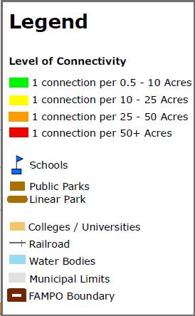
24 Map 4.1: Neighborhood Interconnectivity Central Fayetteville 20
25 5.0 Sidewalks 5.1 Sidewalk Ordinances Appropriate steps need to be taken to overcome conflicts that exist between cyclists, pedestrians, and motorists due to continued growth and development in the FAMPO region. Over the years, Cumberland County has experienced a tremendous amount of commercial development which has transformed streets that were once rural or residential in character into major thoroughfares, many of which without sidewalks. An important consideration in this Connectivity Analysis is the understanding of sidewalk requirements in the municipalities that comprise the FAMPO study area. It is difficult to achieve the goal of connectivity when streets that cross municipal lines are governed by different and potentially conflicting sidewalk regulations. In addition to noting the local requirements, this chapter will also detail the sidewalk requirements of other North Carolina municipalities. These examples are included to serve as a reference for municipal and elected officials when considering revision to existing ordinances. Recommendation: In an effort to enhance connectivity across municipal boundaries, a regional approach to standardized sidewalk requirements should be studied and sidewalk requirements based on the level of roadway (local, collector, thoroughfare, arterial) and should be applied as uniformly as possible. Cumberland County Zoning Ordinance, Section 604, Development Performance Standards Sidewalks must be provided in accordance with the standards of the County Subdivision Ordinance. Subdivision Ordinance, Section Sidewalks shall be required to be constructed in the following instances: 1. Urban Density When a residential development is proposing lots or units at a density of five or more lots/units per acre, sidewalks are required on one side of all streets and along any abutting minor thoroughfare or higher classification street. 2. Suburban Density When a residential development is proposing lots or units at a density that is less than 5 lots/units per acre but greater than 2 lots/units per acre, sidewalks are not required internally within the development; however, sidewalks shall be constructed along any abutting minor thoroughfare or higher classification street. 3. When any development is proposed adjacent to an existing public school or public park property, the developer shall construct and dedicate to the affected public agency a walkway (sidewalk) not less than 10 in width in such a location as to facilitate direct convenient access to the adjacent school or park; and 4. When a non-residential development is proposed along a minor thoroughfare or higher classification street, sidewalks are required along the affected thoroughfare or higher classification street. Subdivision Ordinance, Section , Manufactured Home Parks Pedestrian Circulation. All manufactured home parks shall contain and maintain minimum three-foot wide internal pedestrian paths to central facilities such as pools, office areas, laundry facilities, recreation areas, bus stops, etc. These paths, at a minimum, shall consist of a top layer of sand, crushed gravel or similar approved material. The location of these paths shall be shown on the site plan. No building/park final inspection can be accomplished until these paths are installed. Town of Linden Subdivision Ordinance, Section 404, Streets Access to Parks, Schools, Etc. Street shall be designed or walkways dedicated to assure convenient access to adjacent parks, playgrounds, schools and other public places. Dedicated walkways shall not be less than 10 in width. 21
26 Section 405, Sidewalks Sidewalks are required to be constructed in the following instances: 1. Urban Density When a residential developer is proposing lots or units at a density of 2.2 or more lots/units per acre, sidewalks are required on one side of all streets and along any abutting minor thoroughfare or higher classification street. 2. Suburban Density When a residential development is proposing lots or units at a density that is less than 2.2 and greater than one dwelling unit or lots per acre, sidewalks are not required internally within the development; however, sidewalks shall be constructed along any abutting minor thoroughfare or higher classification street. 3. When an development is proposed adjacent to an existing public school or public park property, the developer shall construct and dedicate to the affected public agency a walkway (sidewalk) not less than 10 in width in such a location as to facilitate direct convenient access to the adjacent school or park; and 4. When a non-residential development is proposed along a minor thoroughfare or higher classification street, sidewalks are required along the affected thoroughfare or higher classification street. Subdivision Ordinance, Section , Manufactured Home Parks Pedestrian Circulation. All manufactured home parks shall contain and maintain minimum three-foot wide internal pedestrian paths to central facilities such as pools, office areas, laundry facilities, recreation areas, bus stops, etc. These paths, at a minimum, shall consist of a top layer of sand, crushed gravel or similar approved material. The location of these paths shall be shown on the site plan. No building/park final inspection can be accomplished until these paths are installed. Town of Eastover The Town of Eastover has adopted sidewalk requirements from the Cumberland County Subdivision Ordinance, Section Sidewalks shall be required to be constructed in the following instances: 1. Urban Density When a residential development is proposing lots or units at a density of five or more lots/units per acre, sidewalks are required on one side of all streets and along any abutting minor thoroughfare or higher classification street. 2. Suburban Density When a residential development is proposing lots or units at a density that is less than 5 lots/units per acre but greater than 2 lots/units per acre, sidewalks are not required internally within the development; however, sidewalks shall be constructed along any abutting minor thoroughfare or higher classification street. 3. When any development is proposed adjacent to an existing public school or public park property, the developer shall construct and dedicate to the affected public agency a walkway (sidewalk) not less than 10 in width in such a location as to facilitate direct convenient access to the adjacent school or park; and 4. When a non-residential development is proposed along a minor thoroughfare or higher classification street, sidewalks are required along the affected thoroughfare or higher classification street. Subdivision Ordinance, Section , Manufactured Home Parks Pedestrian Circulation. All manufactured home parks shall contain and maintain minimum three-foot wide internal pedestrian paths to central facilities such as pools, office areas, laundry facilities, recreation areas, bus stops, etc. These paths, at a minimum, shall consist of a top layer of sand, crushed gravel or similar approved material. The location of these paths shall be shown on the site plan. No building/park final inspection can be accomplished until these paths are installed. Town of Godwin Subdivision Ordinance, Section 3.13, Access to Parks, Schools, Etc. - Streets shall be designed or walkways dedicated to assure convenient access to adjacent parks, playgrounds, schools, and other public places. Dedicated walkways shall not be less than ten (10) feet in width. 22
27 Subdivision Ordinance, Section d (8), Requirements for Mobile Home Parks Pedestrian Circulation Provisions. All mobile home parks shall contain and maintain minimum three (3) foot wide internal pedestrian paths to central facilities such as pools, office areas, laundry facilities, recreation areas, bus stops, etc. These paths, at a minimum, shall consist of a top layer of sand, crushed gravel or similar approved material. The location of these paths shall be shown on the site plan. No occupancy permit shall be issued until these paths are installed. Town of Stedman Subdivision Ordinance, Section 3.13, Access to Parks, Schools, Etc. Streets shall be designed or walkways dedicated to assure convenient access to adjacent parks, playgrounds, schools or other public places. Dedicated walkways shall not be less than ten (10) feet in width. Subdivision Ordinance, Sidewalks, Section 4.3.g All new development inside the Town of Stedman or its Municipal Influence Area (MIA) fronting on a public or private street shall be required to construct a minimum of four foot wide concrete sidewalk along the existing street(s) and all new streets, except for cul-de-sacs serving eight or less residential lots or units. Walks along designated major or minor thoroughfares and collector streets as defined in the Highway Plan shall be a minimum of five feet wide. This shall apply to the development on both sides of the street. The cost of these required walks shall be borne by the developer. All walks shall meet the Americans with Disabilities Act (ADA) standards. When walks are installed adjacent to parking areas, the walks shall be six feet wide to accommodate vehicular bumper overhang. All sidewalk plans must be reviewed and approved by the town of Stedman. Town of Falcon Subdivision Ordinance, Section 3.13, Access to Parks, Schools, Etc. Streets shall be designed or walkways dedicated to ensure convenient access to adjacent parks, playgrounds, schools or other public places. Dedicated walkways shall not be less than 10 in width. Town of Hope Mills Zoning Ordinance, Section 102A-604.c.(5) Sidewalks shall be provided in accordance with the standards of Chapter 86. (Subdivision Ordinance, referenced below) Subdivision Ordinance, Sidewalks, Section 86A-405 Sidewalks shall be required to be constructed in the following instances. 1. When a residential development with a density greater than or equal to 2.2 units per acre is proposed, sidewalks are required on one side of all streets proposed within the development and along any existing minor thoroughfare or higher classification street. Streets ending with a cul-desac or hammerhead turnaround when less than 500 feet in length are not required to have sidewalks. Sidewalks are also not required around the bulb of any cul-de-sac or t-type ending of any hammerhead. 2. When an development is proposed adjacent to an existing public school or public park property, the developer shall construct and dedicate to the affected public agency a walkway (sidewalk) not less than 10 in width in such a location as to facilitate direct convenient access to the adjacent school or park; and 3. When a non-residential development is proposed along a minor thoroughfare or higher classification street, sidewalks are required along the affected thoroughfare or higher classification street. Subdivision Ordinance, Section 86A-504.g(12) Manufactured Home Parks Pedestrian Circulation. All manufactured home parks shall contain and maintain minimum three-foot-wide internal pedestrian paths to central facilities such as pools, office areas, laundry facilities, recreation areas, bus stops, etc. These paths, at a minimum, shall consist of a top layer of sand, crushed gravel or similar approved material, crowned or sloped to ensure surface drainage. The location of these paths shall be shown on the site plan. No building/park final inspection can be accomplished until these paths are installed. 23
28 Town of Spring Lake Subdivision Regulations Section (F) Sidewalks. In any subdivision located within the town, sidewalks shall be required on one side of the street, the location to be determined by the Building Inspector. Further, such sidewalks shall be installed by the subdivider in accordance with the town specifications. Town of Wade Subdivision Ordinance, Section Access to Parks, Schools, Etc. Streets shall be designed or walkways dedicated to assure convenient access to adjacent parks, playgrounds, schools and other public spaces. Dedicated walkways shall not be less than ten (10) feet in width. Subdivision Ordinance, Section 3.23.d(8) Pedestrian Circulation Provisions. All mobile home parks shall contain and maintain minimum three (3) foot wide internal pedestrian paths to central facilities such as pools, office areas, laundry facilities, recreation areas, bus stops, etc. These paths, at a minimum, shall consist of a top layer of sand, crushed gravel or similar approved material. The location of these paths shall be shown on the site plan. No occupancy permit shall be issued until these paths are installed. Subdivision Ordinance, Section 4.1h. Sidewalks - All developments with new streets shall be required to construct asphalt sidewalks on one sided of all new streets. These sidewalks are required a minimum width of four (4) feet adjacent to the asphalt curb and gutter. Harnett County Subdivision Ordinance, Sidewalks, Section Street Classification Major Thoroughfare Minor Thoroughfare Collector, Local or Cul-de-Sac Streets in any Non-Residential or Multi-Family Development All streets in any Neo-Traditional Development Collector Streets in any Residential Development Local Street or Cul-de-Sac Street in any residential development Private Street Location Both sides of the street Both sides of the street Both sides of the street Both sides of the street One side of the street One side of the street Same standard as above for comparable public street Hoke County Subdivision Ordinance, Street Cross Sections, Section 3.3 Sidewalks are required on one side of the street for all subdivisions and the Board of Commissioners may require sidewalks on both sides of the road where the Board determines that pedestrian activity may warrant it. Exception: 1. For subdivisions consisting of ten lots or less in all residential zoning districts, sidewalks are not required if no future phases or future road connections are planned or constructed for the subdivision and if the subdivision is served by only one road than is no longer than 1,000 feet in length. 2. In approving a preliminary plan the Board of Commissioners may reduce the sidewalk requirement by up to 50 percent when in the Board s opinion other pedestrian amenities such as trails and greenways provide equal or better performance. 24
29 City of Fayetteville The City of Fayetteville recently (November 2010) adopted a Unified Development Ordinance (UDO) which addresses pertinent development standards, so both previous and newly adopted sidewalk regulations will be noted. The new UDO will go into effect July 1, Section (5) Sidewalks 1. In any subdivision located within the jurisdiction of the city, sidewalks shall be constructed on one side of all streets with the exception of cul-de-sac streets less than 500 feet in length or on any existing soil street. Sidewalks are not required around the bulb of any cul-de-sac street. 2. Collector and arterial streets, as defined in the adopted city area thoroughfare plan, that abut the development on one side of the street shall include the construction of sidewalks on that side of the street for that portion of the development that abuts the street. Developments that abut both sides of a collector or arterial street shall include the construction of sidewalks on both sides of the street for that portion of the development that abuts the street. 3. In lieu of constructing the required sidewalk, a waiver may be granted after the Planning Commission holds a public hearing and provides a recommendation to City Council at such time the Council shall make the determination on the waiver whereby allowing the applicant to pay a fee in lieu of the required sidewalk construction. Fayetteville UDO, Sidewalks, Section 30-5.F Sidewalks shall be required on both sides of all streets, except: 1. On lots or sites engaged in active agricultural uses in the AR district (in these instances, no sidewalks are required); 2. In residential subdivisions where the average lot size is greater than 35,000 sf in area (in these instances, sidewalks are required on one side of the street); 3. Along alleys; 4. In cases where environmental or topographic conditions make such provision impractical; and 5. When an in-lieu fee consistent with the city s fee schedule is determined to be appropriate by the city. UDO, Section 30-6.I Subdivision The payment of fees, in-lieu of installing a required public sidewalk may occur at the request of the developer with approval of the Director of Engineering, upon finding that: 1. The street is designated as a state highway or route subject to widening or improvement in the foreseeable future; 2. The street is planned for improvement in accordance with the City s transportation plan; 3. Alternate on-site pedestrian facilities, such as trails, greenway, or multiuse paths, are adequate; or 4. The right-of-way, developing lot, or lot abutting a proposed sidewalk is not suitable for sidewalks due to floodplains, wetlands, riparian buffers, required tree canopy retention areas, slopes exceeding 25 percent, or other unique site conditions. 25
30 5.2 Sidewalk Requirements in Select North Carolina Municipalities As a comparison, the following section details the sidewalk requirements in Raleigh, Durham, Charlotte, and Greensboro. North Carolina Municipality Raleigh Roadway Classification Principal Arterial Secondary Arterial Major Thoroughfare Minor Thoroughfare Collector Street Residential Collector Commercial Street Marginal Access Street Residential Street Minor Residential Street Sidewalks Required Both Sides Both Sides Both Sides Both Sides One Side One Side One Side One Side One Side One Side Raleigh: All public roadways inside the corporate limits of the City (and outside the City when connected to the City utility system) shall be constructed with sidewalk. Sidewalks are not required in the following instances: (1) Minor residential streets serving no more than 10 dwelling units; (2) Commercial Dead End Streets which are less than 150 in length; (3) Sensitive area thoroughfares or roadways located within a reservoir watershed protection area overlay district unless connected to city water/sewer and is within ½ mile of a school, shopping center, shopping area, or a connection to a greenway or public park, in which case a sidewalk shall be constructed to standards compatible with a non-curb and gutter street section. North Carolina Municipality Durham Rural Tier Suburban Tier Urban Tier Compact Neighborhood Downtown Tiers Freeways None None None None Major/Minor None Both Sides Both Sides Both Sides Thoroughfare Collectors None Both Sides Both Sides Both Sides Nonresidential Street None One Side Both Sides Both Sides >2,000 daily trips Nonresidential Street None One Side One Side Both Sides <2,000 daily trips Residential Street None One Side One Side Both Sides Cul-de-Sac None One Side One Side Both Sides >400 linear feet Cul-de-Sac <400 linear feet None None One Side Both Sides 26
31 Durham: Unless the approving authority approves an alternate walkway or notes that the cost of providing the required sidewalk is disproportionate to the cost of the proposed development, a conventional sidewalk shall be provided along streets within the right-of-way as shown in the table above. North Carolina Municipality Charlotte Roadway Classification Major Arterial Minor Arterial Collector Street Local Residential Local Limited Residential Sidewalks Required Both Sides Both Sides Both Sides Both Sides Both Sides* *Charlotte: Sidewalks required on both sides except for street that access less than 10 lots or less than 250 feet in length are only required to construct sidewalk on one side of the street. In addition, sidewalks are required along the property frontage along existing thoroughfares at the time of development. North Carolina Municipality Greensboro Roadway Classification Major Thoroughfare Minor Thoroughfare Traditional Neighborhood Development (TND) Collector Street Local Streets Sidewalks Required Both Sides Both Sides Both Sides One Side* At Least One Side *Greensboro: The Technical Review Committee may require sidewalks on both sides of Collector Streets when: (1) the current or projected ADT is greater than 8,000 vehicles per day; (2) the posted speed limits is greater than 35 mph; (3) the street is a strategic pedestrian route to a specified pedestrian destination located within ¼ mile; (4) or there are pedestrian safety, access, or circulation needs that necessitate sidewalks on both sides of the street. Sidewalks are not required along new and existing cul-de-sac streets and permanent dead-end streets that do not exceed 800 feet and that are not strategic pedestrian routes. 27
32 6.0 Recommendations Recommendations from the Connectivity Study must comprehensively address issues of access and safety for bicyclists and pedestrians. With significant input from FAMPO staff, municipal staff, residents, and consultants, and given the extent to which connectivity must be addressed throughout the study area, thorough analysis has produced an ambitious suite of recommendations. The most appropriate recommendations for the FAMPO study area have taken the form of a proposed network of routes and corridors, integrated with a toolbox of safety treatments applied to intersections, crossings, and geographical challenges for bicyclists and pedestrians alike. Connectivity Study analysis has yielded a proposed bicycle and pedestrian network comprised of miles of both planned and existing routes and corridors miles include recommended improvements to particular segments at the street block level. These recommended improvements include sidewalks, multi-use trails, bicycle lane striping, share the road markings, bicycle signage, and other specific improvements aimed at addressing existing and anticipated challenges. Corresponding analysis has yielded safety treatment recommendations for 224 intersections, pedestrian connections, mid-block crossings, and underpasses. These recommendations include intersection striping, pedestrian signals, pedestrian/bicycle signage, pedestrian refuges, and pedestrian channelization median aimed at preventing pedestrians from crossing roads at confirmed hazardous locations. These combined network recommendations are estimated to increase access and connectivity for approximately 268,218 FAMPO study area residents. Metrics produced by the analysis measure access as being within a ½ mile service area of the network. Connections are a measure of the number of destinations with a ¼-mile walk of the network. Table 6.1 below summarizes metrics yielded by the analysis. FAMPO Bicycle & Pedestrian Connectivity Study Network Metrics Analysis Metrics Total % FAMPO Area Route Total Length 791 N/A Proposed Bicycle Routing 791 N/A Connections & Destinations Neighborhoods within Walking Distance % Colleges & Universities within Walking Distance 3 100% Schools within Walking Distance 82 90% Senior Centers within Walking Distance 12 75% Parks wihin Walking Distance 77 94% Bus Stops within Walking Distance % Access Children within Service Area 78,071 81% Seniors within Service Area 24,189 82% Total Residents within Service Area 268,218 80% Low-Income Households within Service Area 38,162 84% Table
33 6.1 Routes & Corridors Neighborhood Corridor The proposed connectivity routing is rooted in a mile spine network of Neighborhood Corridors. These corridors include both existing and proposed sidewalks, trails, greenways, and safe roadways available to walkers and bicyclists. These routes generally make cross-town connections while linking neighborhoods and destinations. The primary attribute of Neighborhood Corridors is that they are routes which will safely accommodate travel by both foot and non-motorized vehicles. Many of the Neighborhood Corridors require improvements such as sidewalks, signage, and intersection/street crossing improvements along the route. Bicycle Connectors Bicycle Connectors are generally on-road bicycle routes which link neighborhoods and destinations, and complete the spine of the network miles of bicycle connector routes exist where pedestrian travel is not recommended, due either to extended distances which likely prohibit foot travel, or a lack of feasible facilities for safe pedestrian travel. Many of these roads are, however, viable facilities for bicycle travel with appropriate investments in bicycle signage and lane striping. Creek Corridors Creek Corridors are routes generally located adjacent to streams and creeks, and account for miles of the network. The primary facility design for these corridors would be a 10-foot wide paved greenway. Final routing within creek corridors will need to be considerate of environmental constraints such as wetlands, topography, and environmentally sensitive areas. Because several creeks traverse the FAMPO region, linking neighborhoods and destinations, these corridors could evolve into a highly effective off-road system for bicycle and pedestrian travel. Neighborhood Collectors Neighborhood Collectors are routes which tend to be more internal to neighborhoods. While they are not central to the cross-town connection of destinations, these miles of routes are essential to providing accessibility. They represent safe, neighborhood-scale roads which residents can use to access both Neighborhood Corridors and Bicycle Connectors. In many cases, Neighborhood Collectors are also used to access destinations internal to neighborhoods such as parks and schools. These routes typically require little or no improvement and offer a tangible connectivity benefit to neighborhoods and residents. 29


34 Existing Bike Lanes Existing Bike Lanes are on the ground bicycle lanes which are currently striped and in use. These facilities, referred to as multi-use bike lanes within the FAMPO study area, are 4-5 feet in width and are marked with standard bike lane stencils. Currently there are seven such facilities within the study area, totaling 4.3 miles, and all located within the City of Fayetteville. Existing bike lanes are important in that they indicate areas where bicyclist may currently ride, or where existing conditions may be suitable for bicycle and pedestrian activity. Eastwood Ave, Fayetteville Map 6.1 below is an excerpt from the FAMPO Proposed Bicycle & Pedestrian Network - Central Fayetteville area map. Mapping for the full network has been distributed among five area maps, and is visible in whole on the Full Network Map. Please see Appendix 1.1 for all maps detailing the proposed network. Map 6.1. Proposed Bicycle & Pedestrian Network Central Fayetteville 30


35 6.2 Bicycle Proficiency Bicycle proficiency refers to the varied levels of skill and experience among bicycle riders in the FAMPO Study Area. Proficiency is important, as different bike facilities and routes can be designated and designed differently to meet these varying levels of skill. For example: Many experienced riders report being comfortable riding along rural roads and among low-volume, mixed vehicle traffic. For these riders, wide paved shoulders along long stretches or rural road may be preferable. Novice riders, such as children and those just beginning, report comfortable only with bike facilities which are separated from motor vehicles. For these riders, multi-use paths may be appropriate. Identifying routes which meet the needs of various proficiencies is important to ensuring connectivity between destinations for all riders. Three proficiency levels among bicycle riders have been identified for the purposes of the Connectivity Study: All Riders, Experienced Riders, and Expert Riders. Facilities for all riders are those which are separated from vehicle traffic and suitable for novices, such as multi-use paths, greenways, and the lowest-volume neighborhood streets. Facilities for experienced riders include those identified for novice riders, as well as sidewalks adjacent to roadway facilities and some on-street facilities such as bicycle lanes and shared lanes. Facilities for expert riders include those identified for experienced riders, as well as bicycle lanes and paved shoulders along higher-volume roads. Map 6.2 is an excerpt from the North Fayetteville & Spring Lake - Bicycle Proficiency map. See Appendix 1.3 for full Bicycle Proficiency mapping. Map 6.2: Bicycle Proficiency North Fayetteville & Spring Lake 31

36 6.3 Recommended Route Improvements Sidewalks Sidewalks are a basic facility designed to provide pedestrians with access to the many destinations and land uses located along road corridors or within individual developments. Sidewalks are most effective for transportation when they are continuous, located on both sides of the street, and wide enough to accommodate multiple pedestrians walking side by side. Sidewalks are particularly important within the FAMPO region as local ordinances allow bicyclists and pedestrians alike to use sidewalk facilities. This establishes existing and planned sidewalks as major assets to bicycle connectivity throughout the study area. Figure 6.1: Sidewalk Typical 88.4 miles of the proposed network are recommended for sidewalk improvements. In most cases, new sidewalks are recommended. In some instances, the recommended improvement is the completion or filling in of sidewalk gaps. Sidewalks are recommended at a width of 5 feet and should be located either adjacent to curb and gutter, or on the backside of roadway ditches a design typically found on suburban and rural roads. The preferred location for sidewalks behind curb and gutter is at an offset distance of at least 5 feet, buffered by vegetation. Figure 6.1 displays the recommended typical section for sidewalks. Please see Appendix 2.1 for all of the recommended typical sections. 32


37 Bicycle Lanes Bicycle lanes are striped on-street travel facilities designed for bicyclists. They provide a dedicated space for bicycle traffic, primarily on collector and arterial roads, where taking the lane may not be a safe option. Bicycle lanes also offer the added benefits of reducing vehicle lane widths, thereby encouraging lowered motor vehicle speeds, and providing an additional buffer between motor vehicle traffic and any adjacent pedestrian facilities. Bicycle lanes are recommended for miles of the proposed network, at a width of at least 4 feet where adjacent to curb and gutter, and 5 feet where included within paved shoulder. Paved shoulder design is typically Bicycle Lane, University Place, WA Photo courtesy of Carl Sundstrom: found on suburban and rural roads. Figure 6.2 displays a recommended typical section for bicycle lanes. Please see Appendix 2.1 for all of the recommended typical sections. Figure 6.2: Bicycle Lane Typical 33


38 Bicycle Signage Bicycle signage is an appropriate improvement in areas where facilities such as bicycle lanes and sidewalks are not feasible, yet routes must be clearly designated. Signage serves to make bicycle riders aware of preferred routes, and make drivers aware of the presence of bicycle traffic along a roadway facility. Awareness of multiple transportation modes along a particular road corridor is essential to establishing safety for all users. Dunn Rd & Church St, Wade Main Street, Wade In the context of the Connectivity Study, bicycle signage is recommended in the form of Share the Road signs located along miles of the proposed network. These are 18 x 24 text signs and should be accompanied by 30 x 30 graphic bicycle signs (See Figure 6.3). In accordance with the 2009 Federal Highway Administration Manual on Uniform Traffic Control Devices ( Share the Road signage must be located at least 50 feet in advance of the improvement, and also recommended at regular intervals along the facility. It is important to note that when traveling on roadways either designated as Share the Road segments, or undesignated bicycles are considered vehicles. They are subject to the same laws, protections, and responsibilities as motor vehicles. Figure 6.3: Share the Road Signage FHWA Manual on Uniform Traffic Control Devices *Indicates fluorescent yellow-green background color Shared Lane Arrows Shared Lane Arrows, often referred to as Sharrows, combine the best elements of bicycle lanes and bicycle signage on roadway facilities. Sharrows are appropriate where travel lane widths may not permit separate bicycle lanes, and traffic speeds and volumes are low enough that riders may comfortably take the lane. Sharrows are typically appropriate on roads with speed limits of 35mph or less. Sharrows are currently recommended for 2.7 miles of roadway within the proposed network. Sharrow - Asheville, NC Photo courtesy of Lyubov Zuyev: 34

39 Multi-Use Trails Multi-use trails take the form of paved paths intended to serve multiple modes of travel including walking, jogging, bicycling, and other forms of non-motorized transport. Multi-use trail facilities and greenway facilities are typically similar in design; greenways are often found in natural areas, designed with adequate vertical and horizontal clearance for users, and may be designed to minimize effects on environmentally sensitive areas. Because multi-use trails are separate from roadway corridors they can be designed to make direct connections to community destinations miles of the proposed network are recommended for multi-use trail or greenway design. These facilities are recommended at a paved width of 10 feet with 5-foot unpaved shoulders on either side. Figure 7.4 displays a recommended typical section for multi-use trails. Please see Appendix 2.1 for all of the recommended typical sections. Figure 6.4: Multi-Use/Greenway Trail Typical 35


40 Bike Thruway Bike Thruway is recommended as a pilot project for the FAMPO area, along West Rowan Street near downtown Fayetteville (Map 6.3, below). Based on the more customary bike boulevard design, bike thruway is designated as a bicycle-preferred, shared-use roadway along a significant transportation corridor, capitalizing on existing characteristics while retaining current motor vehicle access. Map 6.3: West Rowan Street - Bike Thruway Roads are typically chosen for bike boulevard designation because they exhibit the following characteristics: Local road with low vehicle volume Residential in character (preferred) Low speed limits (25 mph or less) Alternative to parallel major roads Connect destinations Right-of-way assigned to the bike boulevard at intersections Physical design discourages motor vehicle thru traffic Human-scale design Clearly-designated pavement markings and signage Bike Boulevard - Portland, OR Photo courtesy of BikePortland.org: 36


41 West Rowan Street is ideal for bike thruway design for the following reasons: Exclusively residential in character west of Martin Luther King Freeway bridge Connects existing bicycle lanes and neighborhood park in Haymount/Westmont area to Rowan Park, planned linear park, and downtown Fayetteville Runs parallel to both Hay Street and Bragg Boulevard major alternate vehicle routes Continuous right-of-way at intersections West Rowan Street 0.7 miles of Bike Thruway design are proposed for West Rowan Street beginning at Oakridge Ave and ending at the planned realignment of Bragg Blvd (NCDOT Project B-4490). Improvements associated with this design include prominently displayed sharrows, sidewalk where appropriate, and segmented median landscaping designed to calm traffic while allowing for turning movements. Figure 6.5 illustrates the recommended typical section for the Bike Thruway (also available in Appendix 2.1). Figure 6.5: Bike Thruway Typical 37

 poses a serious threat to those on foot or bike.")
42 6.4 Intersections & Crossings Intersections play a significant role in bicycle and pedestrian connectivity in that they are a designed meeting point for both pedestrian and motor vehicle traffic. Nationally in 2008, 35% of pedestrian deaths among people aged 60+ occurred at intersections, compared with 20% for those aged 60 and under. Intersections accounted for 38% of all bicycle deaths in 2008 (Insurance Institute for Highway Safety, Fatality Facts: The presence of multiple conflict points (between motor vehicles and bicycles or pedestrians) poses a serious threat to those on foot or bike. Larger intersections tend to have more lanes, thereby increasing the number of conflict points and increasing the overall threat. The same is true of roadway crossings in general. Most two-lane roadways present at least two conflict points to crossing bicyclists or pedestrians: collision on the left side, or collision on the right. Safety treatments are intended to either counteract threats posed by intersections and crossings, or ensure that all users are aware of their presence. Recommendations from the Connectivity Study include several safety treatments at many of the 211 identified intersections and crossings. Map 6.4 below is an excerpt from the Intersections & Crossings Hoke County area map. Please see Appendix 1.2 for full maps detailing intersection and crossing recommendations as well as a summary of intersection improvements. Map 6.4. See Appendix Section 1.2 for full Intersections & Crossings mapping. 38


43 Striped Crosswalks The vast majority of intersections within the FAMPO Study Area either do not have painted crosswalks, or utilize the standard parallel line crosswalk. There are two drawbacks associated with parallel line crosswalk design which negatively impact safety: First, the thin parallel lines rank low in visibility, particularly from great distances often motor vehicles approaching an intersection do not come to a complete stop until they are well across the lines. Secondly, the minimal paint associated with the design shortens the life of these crosswalks they can become faded and worn away relatively quickly. Village Dr & Ireland Dr: Worn parallel line crosswalk (near side) is difficult to detect. It is recommended that crosswalks in the study area utilize a zebra crosswalk design. Zebra crosswalks utilize vertical lines (as opposed to horizontal parallel lines) which are significantly wider. This design presents more of a visual cue to drivers and pedestrians alike. The intentionally wide-spaced line design also allows the crosswalk to better avoid wear from vehicle tire treads. Fort Bragg Rd: Zebra crosswalk design offers high visibility 151 Study Area intersections are recommended for zebra crosswalk design; recommendations include which side(s) of the intersection should be striped North, South, East, and/or West. In some cases, identified intersections currently have some form of crosswalk marking in these cases upgrading to zebra striping is recommended. Please see Appendix 3 for a summary of crosswalk improvements. Pedestrian Signals Pedestrian signals are an essential feature at many intersections. While some intersections are located on narrow roads with few lanes, and low traffic volumes, others are located on major arterial roads with high speeds and high traffic volumes. On these larger facilities, and others, pedestrians and bicyclists alike rely on pedestrian signals to inform them when traffic has stopped and sufficient time is available for them to cross the street. In addition to the visual information and cues, modern pedestrian signals are also equipped with auditory signals which inform visually impaired users when to cross and how much time is available for them to cross. Pedestrian signals are recommended at 65 intersections where roadway volumes and context warrant. In rare cases, identified intersections may have existing signals in these cases it is recommended that additional signals be included at recommended crosswalk locations. See Appendix 3 for a summary of pedestrian signal improvements. 39


44 Crosswalk Signage Crosswalk signage is important at intersections and other crossings because it informs pedestrians, bicyclists, and drivers of the presence of pedestrians and potential for users crossing travel lanes. Signage alone can be an effective intersection safety improvement for smaller, low traffic, low speed intersections. It can also be effective for alerting drivers and crosswalk users to the presence of midblock crossings. Murchison Road: Crosswalk Signage The Connectivity Study recommends crosswalk signage at 99 intersections, connectors, and mid-block crossings where roadway volumes and characteristics warrant. Signage should always be used in conjunction with striped crossings, and is also recommended for some signalized intersections to increase awareness of crossings. HAWK Signal HAWK is an acronym for High-Intensity Activated CrossWalK; also referred to as a pedestrian hybrid beacon. A HAWK signal functions similarly to a standard traffic signal in directing oncoming motor vehicle traffic to slow and stop, however it is activated by pedestrians or bicyclists, and its signal pattern is phased to accommodate safe pedestrian crossings (see Figure 6.6 below). HAWK signals are warranted at crossings with high pedestrian and bicycle traffic volumes, moderate to high vehicle volumes, and no other signalized crossings within 300 feet. HAWK Signal, Phoenix, AZ. Photo courtesy of Mike Cynecki Figure 6.6: HAWK Signal Phasing Diagram. FHWA Manual on Uniform Traffic Control Devices A HAWK signal is recommended for the intersection of Lake Avenue and Bragg Boulevard in Spring Lake. This signal recommendation takes into account recommendations from the previously completed Spring Lake Multi-Modal Congestion Management Plan (2009). 40


45 Rapid Rectangular Flashing Beacons Rapid Rectangular Flashing Beacons (RRFB) granted Interim Approval by the Federal Highway Administration in 2008 are a relatively new and innovative treatment for enhancing safety and awareness at road crossings. RRFBs are solar-powered, user-actuated (similar to existing pedestrian crossing signals) amber LED lights which are used as a supplement to approved pedestrian and school crossing signs. The RRFB employs an irregular flash pattern similar to flashers on emergency vehicles. RRFBs are an ideal tool in that they are a lowcost alternative to both traffic signals and HAWK signals, and, in testing, have led to comparable vehicular yield rates while requiring lessened traffic warrants. RRFBs are recommended at 9 mid-block crossings and crosswalks in the FAMPO Study Area. In selecting these locations, proximity to schools, vehicular traffic data, and presence of multi-lane crossings were considered. Rectangular Rapid Flashing Beacon, St. Petersburg, FL Photo courtesy of Michael Frederick. Jurisdictions wishing to install RRFBs must have approval from the FHWA Office of Transportation Operations, and must comply with general operation requirements. Please see Appendix 2.3 for RRFB guidelines and information on effectiveness. Mid-Block Crossings Mid-block crossings are an important feature of the Connectivity Study recommendations. In addition to sidewalks, there are many off-road bicycle and pedestrian facilities included in the proposed network. Many of these planned facilities or identified routes must cross roads; often times routing through existing intersections is not feasible. Mid-block crossings are recommended for 38 locations (includes crossing of proposed facilities); primarily on roads with lower traffic volumes and speeds. Midblock crossings should include high visibility zebra Fort Bragg Road: Mid-block crossing striping, and prominent crosswalk signage. They should be located such that there is adequate sight distance (minimum of 400 ft) and lighting for both crosswalk users and motor vehicles. 41


46 Pedestrian Refuges A pedestrian refuge is a human-scale type of traffic island, generally located within the median, or at the midway point of a multi-lane road crossing. Refuges allow pedestrians and bicyclists to focus attention on one direction of traffic at a time, enabling them to stop partway across the street and wait for an adequate gap in traffic before continuing to cross. Refuges should be used in conjunction with striped crosswalks, and serve not only as a safety treatment for users, but offer a visual cue to drivers to slow down for potential pedestrian crossings. They are typically raised median structures, housed in a concrete form to shield users from vehicles. They can be landscaped, brick, or concrete with varied lengths and widths to fit a particular crossing. Pedestrian Refuge, Bellevue, WA. Photo courtesy of Dan Burden Connector In the context of the Connectivity Study, connectors are special improvements recommended for specific bicycle and pedestrian connectivity challenges. These improvements include underpasses, at-grade pedestrian railroad crossings, pedestrian culverts, pedestrian bridges, and simple paths through manmade or natural barriers. It is recommended that each of the 20 recommended improvements undergo complete engineering studies, where applicable, to determine the most feasible solutions. Fairfield Road: This closed road is an ideal location for a recommended pedestrian bridge to the adjacent neighborhood Offing Drive: The recommended pedestrian railroad crossing at this location would mitigate a major connectivity challenge. 42

47 Pedestrian Channelization Median Often times, accidents occur between motor vehicles and pedestrians or bicyclists at locations other than designated intersections and crossings. These can be improvised mid-block crossings or any location where unfavorable sight distance, lighting, or traffic characteristics make crossing the roadway hazardous. For these locations, pedestrian channelization median is recommended to discourage pedestrians and bicyclists from crossing, and visually channel them toward appropriate crossings. Bragg Boulevard As noted earlier in Section 2.1, analysis of past accident history resulted in several locations within the FAMPO Study Area which have been identified as dangerous for crossings. Pedestrian channelization median, in the form of either shrubs or pedestrian barrier gates, is recommended for placement at 15 locations identified on the Intersections & Crossings maps. One such location is the eastern portion of Grove Street in Fayetteville, which has a total of 17 reported bicycle/pedestrian accidents in the past 5 years. The City of Fayetteville and NC Department of Transportation currently have a pedestrian barrier project planned for this facility. 43
48 7.0 Project Prioritization Prioritization for recommended projects is very important in laying out an implementable path to the bicycle and pedestrian connectivity the FAMPO area desires. Project priorities are categorized at three levels: Short Term 0-5 Years Medium Term 5-10 Years Long Term Years Many of the recommended projects are components of larger infrastructure projects or will require investment or agreement from multiple stakeholders. Because of this, project prioritization must take into account the realities of project implementation. Several factors are considered when determining project priority: Importance of the project in completing existing connections. Many of the recommended improvements are components of larger Neighborhood Corridor routes which establish major cross-town connections. The ability of these projects to make a significant impact on regional connectivity and spur additional projects in the FAMPO Study Area has great bearing on their priority. Ability to complete the project quickly, and realize a benefit. This could be referred to as the low-hanging fruit criteria. Many of the recommended projects are small in nature, such as short sidewalk sections, or short trail connections to neighboring destinations. These projects can be completed quickly, and at minimal cost, while immediately enhancing connectivity. Status of the project as a component of a currently-funded project. Many of the recommended projects in the FAMPO Study Area benefit from being a component of larger projects. Some of these include development projects such as the Blount Creek Greenway currently a component of the Campbell Terrace/Delona Gardens HOPE VI Project. Many more projects are components of NCDOT transportation projects. The current schedule for these larger projects is the determining factor in assigning priority for their connectivity components. Recommendations for intersection and crossing improvements take into account recommendations and planned improvements for their respective routes and facilities. Often, recommendations associated with one are vital to the success of the other. For this reason, the level of priority associated with individual intersection and crossing recommendations is a direct reflection of the prioritization of the respective route. Map 7.1 is an excerpt from the Project Prioritization Harnett County area map. It should be noted that the Project Prioritization maps reference recommended improvements and do not reference route segments which are currently on the ground and accessible. These on-the-ground facilities may include sidewalks, existing bike lanes, and other existing facilities. Please see Appendix Section 1.4 for full Project Prioritization mapping. 44

49 Map 7.1: Project Prioritization 45
ACTIVE TRANSPORTATION
 ACTIVE TRANSPORTATION Mobility 2040 Supported Goals Improve the availability of transportation options for people and goods. Support travel efficiency measures and system enhancements targeted at congestion
CONNECTING PEOPLE TO PLACES
 CONNECTING PEOPLE TO PLACES 82 EAST BENCH MASTER PLAN 07 Introduction The East Bench transportation system is a collection of slow moving, treelined residential streets and major arteries that are the
Corpus Christi Metropolitan Transportation Plan Fiscal Year Introduction:
 Introduction: The Safe, Accountable, Flexible, Efficient Transportation Equity Act: A Legacy for Users (SAFETEA-LU) has continued the efforts started through the Intermodal Surface Transportation Efficiency
PEDESTRIAN ACTION PLAN
 ATTACHMENT 2 CITY OF SANTA MONICA PEDESTRIAN ACTION PLAN CITY OF SANTA MONICA PEDESTRIAN ACTION PLAN This page intentionally left blank EXECUTIVE SUMMARY CHAPTER 1 EXECUTIVE SUMMARY Setting the Stage
Perryville TOD and Greenway Plan
 Perryville TOD and Greenway Plan Greenway Glossary Pathway: A bicycle and pedestrian path separated from motorized vehicular traffic by an open space, barrier or curb. Multi-use paths may be within the
Proposed. City of Grand Junction Complete Streets Policy. Exhibit 10
 Proposed City of Grand Junction Complete Streets Policy Exhibit 10 1 City of Grand Junction Complete Streets Policy Vision: The Complete Streets Vision is to develop a safe, efficient, and reliable travel
Exhibit 1 PLANNING COMMISSION AGENDA ITEM
 Exhibit 1 PLANNING COMMISSION AGENDA ITEM Project Name: Grand Junction Circulation Plan Grand Junction Complete Streets Policy Applicant: City of Grand Junction Representative: David Thornton Address:
NM-POLICY 1: Improve service levels, participation, and options for non-motorized transportation modes throughout the County.
 Transportation PRINCE WILLIAM COUNTY 2008 COMPREHENSIVE PLAN NON-MOTORIZED PLAN CONTENTS Goals, Policies, and Action Strategies Table 4 (Bike Facility Classifications and Descriptions) Table 5 (Bike Facility
City of Novi Non-Motorized Master Plan 2011 Executive Summary
 City of Novi Non-Motorized Master Plan 2011 Executive Summary Prepared by: February 28, 2011 Why Plan? Encouraging healthy, active lifestyles through pathway and sidewalk connectivity has been a focus
Appendix 3 Roadway and Bike/Ped Design Standards
 Appendix 3 Roadway and Bike/Ped Design Standards OTO Transportation Plan 2040 4/20/2017 Page A3-1 Adopted Standards The adopted OTO Design Standards and Major Thoroughfare Plan are contained herein.
o n - m o t o r i z e d transportation is an overlooked element that can greatly enhance the overall quality of life for the community s residents.
 N o n - m o t o r i z e d transportation is an overlooked element that can greatly enhance the overall quality of life for the community s residents. 84 Transportation CHAPTER 11 INTRODUCTION Transportation
Living Streets Policy
 Living Streets Policy Introduction Living streets balance the needs of motorists, bicyclists, pedestrians and transit riders in ways that promote safety and convenience, enhance community identity, create
CITY OF BLOOMINGTON COMPLETE STREETS POLICY
 CITY OF BLOOMINGTON COMPLETE STREETS POLICY POLICY OBJECTIVE: The City of Bloomington will enhance safety, mobility, accessibility and convenience for transportation network users of all ages and abilities,
Chapter 2. Bellingham Bicycle Master Plan Chapter 2: Policies and Actions
 Chapter 2 Bellingham Bicycle Master Plan Chapter 2: Policies and Actions Chapter 2: Policies and Actions The Bicycle Master Plan provides a road map for making bicycling in Bellingham a viable transportation
Non-Motorized Transportation 7-1
 Non-Motorized Transportation 7-1 Transportation facilities no longer mean just accommodating a vehicle powered by a combustion engine. Pedestrian and non-motorized facilities are important modes of travel
CITY OF COCOA BEACH 2025 COMPREHENSIVE PLAN. Section VIII Mobility Element Goals, Objectives, and Policies
 CITY OF COCOA BEACH 2025 COMPREHENSIVE PLAN Section VIII Mobility Element Goals, Objectives, and Policies Adopted August 6, 2015 by Ordinance No. 1591 VIII MOBILITY ELEMENT Table of Contents Page Number
CHAPTER 3: Vision Statement and Goals
 Davidson Walks & Rolls: Active Transportation Master Plan CHAPTER 3 Contents: Overview Vision Statement Measurable Goals Public Outreach CHAPTER 3: Vision Statement and Goals Overview The vision statement
Madison Urban Area and Dane County. Bicycle Transportation Plan Summary. September Introduction. Bicycle Plan Scope and Planning Process
 Bicycle Transportation Plan Summary Madison Urban Area and Dane County Introduction September 2000 Bicycling is an important mode of transportation in the Madison urban area and countywide that is available
5. Pedestrian System. Accomplishments Over the Past Five Years
 5. Pedestrian System Accomplishments Over the Past Five Years The Alamo Area Metropolitan Planning Organization (MPO) and its partner agencies recognize the importance of improving pedestrian mobility.
5/7/2013 VIA . RE: University Village Safeway Expansion (P13-019)
") 5/7/2013 VIA EMAIL David Hung, Associate Planner Community Development Department, Current Planning Division City of Sacramento 300 Richards Boulevard, 3 rd Floor Sacramento, CA 95811 RE: University Village
5/7/2013 VIA EMAIL David Hung, Associate Planner Community Development Department, Current Planning Division City of Sacramento 300 Richards Boulevard, 3 rd Floor Sacramento, CA 95811 RE: University Village
4 Goals, Objectives & Actions
 Chapter4 4 This chapter presents goals, objectives, and recommended actions to support the vision of making Overland Park a safer and easier place to ride a bicycle. 35 4.1 Recommendations Structure The
Chapter 7. Transportation. Transportation Road Network Plan Transit Cyclists Pedestrians Multi-Use and Equestrian Trails
 Chapter 7 Transportation Transportation Road Network Plan Transit Cyclists Pedestrians Multi-Use and Equestrian Trails 7.1 TRANSPORTATION BACKGROUND The District of Maple Ridge faces a number of unique
Bikeway action plan. Bicycle Friendly Community Workshop March 5, 2007 Rochester, MN
 Bikeway action plan Summary The was held on March 5, 2007 at the Rochester Mayo Civic Center. The workshop was hosted by Rochester-Olmsted County Planning Department in collaboration with the League of
Solana Beach Comprehensive Active Transportation Strategy (CATS)
") Solana Beach Comprehensive Active Transportation Strategy (CATS) 3.0 Goals & Policies The Solana Beach CATS goals and objectives outlined below were largely drawn from the Solana Beach Circulation Element
Solana Beach Comprehensive Active Transportation Strategy (CATS) 3.0 Goals & Policies The Solana Beach CATS goals and objectives outlined below were largely drawn from the Solana Beach Circulation Element
MAG Town of Cave Creek Bike Study Task 6 Executive Summary and Regional Significance Report
 Page 1 MAG Town of Cave Creek Bike Study Task 6 Executive Summary and Regional Significance Report August 1, 2012 MAG Project #481 Page 2 Task 6 Executive Summary and Regional Significance Report Introduction
EXECUTIVE SUMMARY. Vision
 Vision Walking and bicycling in Salt Lake City will be safe, convenient, comfortable, and viable transportation options that connect people to places, foster recreational and economic development opportunities,
This page intentionally left blank.
 This page intentionally left blank. COMMUNITY Coweta Community Overview Coweta Coweta, a residential community located in Wagoner County, is a suburb of Tulsa situated southeast of the metropolitan area
Chapter 5 Future Transportation
 Chapter 5 Future Transportation The Future Land Use Plan identifies the desired land use designations. The land uses desired for Crozet depend, in large part, on the success of the transportation system,
5/31/2016 VIA . Arwen Wacht City of Sacramento Community Development Department 300 Richards Blvd., 3 rd Floor Sacramento, CA 95811
 5/31/2016 VIA EMAIL Arwen Wacht City of Sacramento Community Development Department 300 Richards Blvd., 3 rd Floor Sacramento, CA 95811 RE: El Pollo Loco (P16-028) Dear Ms. Wacht: WALKSacramento has reviewed
12/4/2016 VIA . RE: Grocery Outlet Del Paso (DR16-328)
") 12/4/2016 VIA EMAIL Ethan Meltzer, Assistant Planner City of Sacramento Community Development Department 300 Richards Blvd, 3 rd Floor Sacramento, CA 95811 RE: Grocery Outlet Del Paso (DR16-328) Dear Mr.
12/4/2016 VIA EMAIL Ethan Meltzer, Assistant Planner City of Sacramento Community Development Department 300 Richards Blvd, 3 rd Floor Sacramento, CA 95811 RE: Grocery Outlet Del Paso (DR16-328) Dear Mr.
Plant City Walk-Bike Plan
 Plant City Walk-Bike Plan Plant City Commute Mode Share 2.2% 1.4% 2.9% Drove alone 10.2% Carpooled Public transportation (0.1%) Walked Used a Bike (0.4%) 82.9% Taxicab, motorcycle, or other means Worked
Roadway Classification Design Standards and Policies. Pueblo, Colorado November, 2004
 Roadway Classification Design Standards and Policies Pueblo, Colorado November, 2004 Table of Contents Page Chapter 1. General Provisions 1.1 Jurisdiction 3 1.2 Purpose and Intent 3 1.3 Modification 3
TOWN OF PORTLAND, CONNECTICUT COMPLETE STREETS POLICY
 TOWN OF PORTLAND, CONNECTICUT COMPLETE STREETS POLICY I. VISION, GOALS & PRINCIPLES VISION To improve the streets of Portland making them safer and more accessible for all users including pedestrians,
DRAFT. Table of Contents. Background
 Douglas County Table of Contents Existing Infrastructure 86 Funding 89 Policy and Program Recommendations 90 Infrastructure Recommendations 92 Conclusion 95 Background Home to 4,500 residents and Baker
8/31/2016 VIA . RE: Freeport Arco Fuel Station (P16-039)
") 8/31/2016 VIA EMAIL Garrett Norman, Assistant Planner City of Sacramento Community Development Department 300 Richards Boulevard, 3 rd Floor Sacramento, CA 95811 RE: Freeport Arco Fuel Station (P16-039)
8/31/2016 VIA EMAIL Garrett Norman, Assistant Planner City of Sacramento Community Development Department 300 Richards Boulevard, 3 rd Floor Sacramento, CA 95811 RE: Freeport Arco Fuel Station (P16-039)
6/14/2013 VIA . Evan Compton, Associate Planner Community Development Department City of Sacramento 300 Richards Blvd Sacramento, CA 95814
 6/14/2013 VIA EMAIL Evan Compton, Associate Planner Community Development Department City of Sacramento 300 Richards Blvd RE: Sacramento Natural Foods Co-Op (P13-025) Dear Mr. Compton: WALKSacramento appreciates
11/28/2016 VIA
 11/28/2016 VIA EMAIL Ethan Meltzer, Assistant Planner City of Sacramento Community Development Department 300 Richards Blvd., 3 rd Floor Sacramento, Ca 95811 RE: Natomas Corporate Center Commercial Building
Chapter 5. Complete Streets and Walkable Communities.
 Chapter 5. Complete Streets and Walkable Communities. 5.1 Description of Complete Streets. Cities throughout the world, and specifically the United States, are coming to embrace a new transportation and
3/10/2016 VIA th Street, Suite 203 Sacramento, CA
 3/10/2016 VIA EMAIL Arwen Wacht, Associate Planner City of Sacramento Community Development Department 300 Richards Boulevard, 3 rd Floor Sacramento, CA 95811 RE: Natomas Fountains (P16-012) Dear Ms. Wacht:
6/22/2018 VIA . Darcy Goulart, Planning Manager City of Rancho Cordova Planning Department 2729 Prospect Park Drive Rancho Cordova, CA 95670
 6/22/2018 VIA EMAIL Darcy Goulart, Planning Manager City of Rancho Cordova Planning Department 2729 Prospect Park Drive Rancho Cordova, CA 95670 RE: Quick Quack Car Wash (DD9801) Dear Ms. Goulart: WALKSacramento
REGIONAL BICYCLE AND PEDESTRIAN DESIGN GUIDELINES
 REGIONAL BICYCLE AND PEDESTRIAN DESIGN GUIDELINES November 16, 2011 Deb Humphreys North Central Texas Council of Governments Bicycle and Pedestrian Advisory Committee Snapshot of the Guide 1. Introduction
Section 9. Implementation
 Section 9. Implementation The transportation system is just one of many aspects that must be carefully planned to maintain and enhance the quality of living in Cecil County. The Cecil County Bicycle Plan
RESOLUTION NO ?? A RESOLUTION OF THE CITY OF NEPTUNE BEACH ADOPTING A COMPLETE STREETS POLICY
 RESOLUTION NO. 2018-?? A RESOLUTION OF THE CITY OF NEPTUNE BEACH ADOPTING A COMPLETE STREETS POLICY WHEREAS, safe, convenient, and accessible transportation for all users is a priority of the City of Neptune
Table of Contents Introduction. 2 Purpose of the Plan...2 The Benefits of Walking and Bicycling...3 Vision and Goals of the Plan...
 BICYCLE AND This plan was created through a grant from the Healthy Communities Program with the cooperation of the City of Cynthiana, Cynthiana Main Street, Cynthiana-Harrison County-Berry Joint Planning
Goal 3: Foster an environment of partnerships and collaboration to connect our communities and regions to one another.
 Non-Motorized Transportation Plan (NMTP) Draft Vision, Goal and,, Tri-County Regional Planning Commission (TCRPC) Purpose The purpose of the Tri-County Regional Planning Commission (TCRPC) Non-Motorized
West Dimond Blvd Upgrade Jodhpur Street to Sand Lake Road
 West Dimond Blvd Jodhpur St to Sand Lake CSS Transportation Project Summary Municipality of Anchorage Project # 05 005 Project Manager: John Smith, P.E. (MOA PM&E) Project Administrator: Julie Makela,
Chapter VISION, MISSION, AND GOALS AND OBJECTIVES. Vision. Mission. Goals and Objectives CONNECTING COMMUNITIES ACROSS THE ST.
 VISION, MISSION, AND GOALS AND OBJECTIVES Chapter 3 The Plan s vision, mission, and goals and objectives were developed through a series of interactive exercises with the Citizens Advisory Committee (CAC)
MASTER BICYCLE AND PEDESTRIAN PLAN
 VILLAGE OF NORTHBROOK MASTER BICYCLE AND PEDESTRIAN PLAN DRAFT PLAN OPEN HOUSE May 2, 2018 AGENDA 1. Community Engagement 2. Vision and Goals 3. General Structure of Plan 4. Recommendations Overview 5.
9/22/2014 VIA . RE: Butano Apartments Pre App (PAMP )
") 9/22/2014 VIA EMAIL Surinder Singh, Senior Planner Planning and Environmental Review Division Sacramento County 827 7th Street, Second Floor RE: Butano Apartments Pre App (PAMP2014-00012) Dear Mr. Singh:
9/22/2014 VIA EMAIL Surinder Singh, Senior Planner Planning and Environmental Review Division Sacramento County 827 7th Street, Second Floor RE: Butano Apartments Pre App (PAMP2014-00012) Dear Mr. Singh:
7/23/2017 VIA . Michael Hanebutt City of Sacramento Community Development Department 300 Richards Boulevard, 3 rd Floor Sacramento, CA 95811
 7/23/2017 VIA EMAIL Michael Hanebutt City of Sacramento Community Development Department 300 Richards Boulevard, 3 rd Floor Sacramento, CA 95811 RE: 65 th Street Apartments (DR17-220) Dear Mr. Hanebutt:
County of Greenville South Carolina. Traffic Calming Program Neighborhood Traffic Education Program and Speed Hump Program
 County of Greenville South Carolina Traffic Calming Program Neighborhood Traffic Education Program and Speed Hump Program (rev) August 2008 I. PURPOSE The potential negative impacts from vehicular traffic
Cyclists and Bikeways: What s your match? A guide to bikeway options for a variety of cyclists
 Cyclists and Bikeways: What s your match? guide to bikeway options for a variety of cyclists The workshop and this resource were made possible by funding from the Province of Ontario via the Ministry of
County of Spartanburg South Carolina
 County of Spartanburg South Carolina Traffic Calming Program June 2012 (Revised/Program on Hold) PURPOSE The potential negative impacts from vehicular traffic on residential roads have been a longstanding
Goodlettsville Bicycle and Pedestrian Plan Executive Summary
 Goodlettsville Bicycle and Pedestrian Plan July 2010 In Cooperation with the Nashville Area Metropolitan Planning Executive Organization Summary Introduction Progressive and forward thinking communities
PEDALING FORWARD. A Glance at the SFMTA s Bike Program for SFMTA.COM
 PEDALING FORWARD A Glance at the SFMTA s Bike Program for 2017-2021 SFMTA.COM INTRODUCTION About This Booklet More people from all walks of life see their bicycle as a more convenient way to get where
CHAPTER 1 INTRODUCTION
 CHAPTER 1 INTRODUCTION Chapter Table of Contents THE 2017 HOUSTON BIKE PLAN 1-1 HOUSTON BIKEWAYS PROGRAM 1-2 HISTORY OF BICYCLE PLANNING IN HOUSTON 1-3 BICYCLE LEVEL OF COMFORT 1-3 EXISTING PLANS, PROGRAMS
Active Transportation Facility Glossary
 Active Transportation Facility Glossary This document defines different active transportation facilities and suggests appropriate corridor types. Click on a facility type to jump to its definition. Bike
WELCOME. Thank you for joining us at the Second Public Workshop for the Carlsbad Pedestrian Master Plan. We look forward to receiving your feedback.
 City of Carlsbad Pedestrian Master Plan: WELCOME WELCOME Please Sign In Provide Input at Flip Charts Review Boards Presentation of Draft Plan Thank you for joining us at the Second Public Workshop for
9/21/2016 VIA . RE: The Knot (DR16-270)
") 9/21/2016 VIA EMAIL Garrett Norman, Assistant Planner City of Sacramento Community Development Department 300 Richards Boulevard, 3 rd Floor Sacramento, CA 95811 RE: The Knot (DR16-270) Dear Mr. Norman:
9/21/2016 VIA EMAIL Garrett Norman, Assistant Planner City of Sacramento Community Development Department 300 Richards Boulevard, 3 rd Floor Sacramento, CA 95811 RE: The Knot (DR16-270) Dear Mr. Norman:
CONTEXT SENSITIVE STREETS STANDARDS COMMITTEE
 CONTEXT SENSITIVE STREETS STANDARDS COMMITTEE February 23, 2015 Prepared by: Denise Chaplick, AICP City Jacksonville Bicycle and Pedestrian Coordinator Source: NCDOT Complete Streets Planning and Design
Broad Street Bicycle Boulevard Design Guidelines
 Broad Street Bicycle Boulevard Design Guidelines Building from the strategies introduced in the 2013 Bicycle Transportation Plan and community input received thus far, City Transportation Staff have identified
General Design Factors
 Chapter 3: 3-1.0 Introduction General Design Factors Mn/DOT s goals include encouraging and accommodating safe bicycling. From a design perspective, these goals are achieved by first having an understanding
4/14/2017 VIA . Miriam Lim, Junior Planner City of Sacramento Community Development Department 300 Richards, 3 rd Floor Sacramento, CA 95811
 4/14/2017 VIA EMAIL Miriam Lim, Junior Planner City of Sacramento Community Development Department 300 Richards, 3 rd Floor Sacramento, CA 95811 RE: Mack & Franklin Development (P17-016) Dear Ms. Lim:
Executive Summary Route 30 Corridor Master Plan
 Route Corridor Master Plan Project Overview The Route Corridor Master Plan is a coordinated multimodal transportation and land use plan for the entire stretch of Route through East Whiteland Township,
Hennepin County Bicycle and Pedestrian Planning
 Hennepin County Bicycle and Pedestrian Planning 1 Value of bicycle and sidewalk systems Safety Livability Mobility Health Personal Finances Economic Sustainability Clean Air Recreation Parking and congestion
How to Develop a Pedestrian Safety Action Plan
 How to Develop a Pedestrian Safety Action Plan Course Introduction Presented by: Peter Eun FHWA RC Safety Engineer Ryan Snyder President, Ryan Snyder Associates, LLC Paul Zykofsky Director, Land Use and
APPENDIX A: Complete Streets Checklist DRAFT NOVEMBER 2016
 APPENDIX A: Complete Streets Checklist DRAFT NOVEMBER 2016 Complete Streets Checklist MetroPlan Orlando s Complete Streets Checklist is an internal planning tool for staff to further implementation of
Agenda. Overview PRINCE GEORGE S PLAZA METRO AREA PEDESTRIAN PLAN
 PRINCE GEORGE S PLAZA METRO AREA PEDESTRIAN PLAN May 28, 2008 Agenda Welcome and introductions Project overview and issue identification Planning context and strengths Design challenges and initial recommendations
10/30/2012 VIA
 10/30/2012 VIA EMAIL David Hung, Associate Planner Community Development Department, Current Planning Division City of Sacramento 300 Richards Blvd., 3 rd Floor Sacramento, CA 95811 RE: The Cannery On-Site
Arlington s Master Transportation Plan
 Arlington s Master Transportation Plan The Master Transportation Plan (MTP) Adopted in eight parts Goals & Policies element and MTP Map adopted in 2007 Bicycle, Pedestrian and Demand and Systems Management
Bicycle Master Plan Goals, Strategies, and Policies
 Bicycle Master Plan Goals, Strategies, and Policies Mobilizing 5 This chapter outlines the overarching goals, action statements, and action items Long Beach will take in order to achieve its vision of
City of Wayzata Comprehensive Plan 2030 Transportation Chapter: Appendix A
 A1. Functional Classification Table A-1 illustrates the Metropolitan Council s detailed criteria established for the functional classification of roadways within the Twin Cities Metropolitan Area. Table
Chapter 2: Standards for Access, Non-Motorized, and Transit
 Standards for Access, Non-Motorized, and Transit Chapter 2: Standards for Access, Non-Motorized, and Transit The Washtenaw County Access Management Plan was developed based on the analysis of existing
GPATS Long-Range Transportation Plan. Complete Streets
 GPATS Long-Range Transportation Plan 5: BICYCLE AND PEDESTRIAN INTRODUCTION Complete Streets As the GPATS region grows, the role the active transportation infrastructure plays in the regional transportation
5 CIRCULATION AND STREET DESIGN
 5 CIRCULATION AND STREET DESIGN This chapter describes circulation and streetscape improvements proposed for the Northwest Chico Specific Plan Area. It includes detailed design specifications for existing
Moving Cambridge. City of Cambridge Transportation Master Plan Public Consultation Centre. March 7, :00 8:00 PM.
 City of Cambridge Transportation Master Plan Public Consultation Centre March 7, 2018 5:00 8:00 PM Region of Waterloo City of Cambridge Transportation Master Plan Public Consultation Centre March 7, 2018
11/3/2014 VIA . WALKSacramento has reviewed the Stockton and T Mixed-Use project at 3675 T Street in the
 11/3/2014 VIA EMAIL Antonio Ablog Planning Department City of Sacramento 300 Richards Boulevard Sacramento, CA 95811 RE: Design Review for Stockton and T Mixed-Use (P14-042) Dear Mr. Ablog: WALKSacramento
Planning Guidance in the 2012 AASHTO Bike Guide
 Planning Guidance in the 2012 AASHTO Bike Guide Presentation by: RJ Eldridge Peter Lagerwey August 22, 2012 WEBINAR 2: PLANNING GUIDANCE IN THE 2012 AASHTO BIKE GUIDE Today s Webinar Significant Updates
Lee s Summit Road Improvement Study Public Open House June 7, 2007 Summary of Comment Card Responses
 Lee s Summit Road Improvement Study Public Open House June 7, 2007 Summary of Comment Card Responses Introduction At the Lee s Summit Road Improvement Study Public Open House held Thursday, June 7, 2007
Transportation Master Plan Advisory Task Force
 Transportation Master Plan Advisory Task Force Network Alternatives & Phasing Strategy February 2016 BACKGROUND Table of Contents BACKGROUND Purpose & Introduction 2 Linking the TMP to Key Council Approved
2.0 Existing Conditions
 20 2.0 Existing Conditions 2.1 Land Use, Future Growth Patterns, Physical Barriers Geographic Overview Sutter County s land use pattern is characterized by extensive agricultural areas, significant natural
Physical Implications of Complete Streets Policies
 Presentation Overview Physical Implications of Complete Norm Cox, ASLA, LLA Landscape Architect Ann Arbor, Michigan, 10:45 to Noon What Are Complete Streets? What Matters to Bicyclists and Pedestrians
ACTIVE TRANSPORTATION/NONMOTORIZED TRANSPORTATION
 ACTIVE TRANSPORTATION/NONMOTORIZED TRANSPORTATION BACKGROUND Active transportation, also known as nonmotorized transportation, is increasingly recognized as an important consideration when planning and
CHAPTER 16 PEDESTRIAN FACILITIES DESIGN AND TECHNICAL CRITERIA TABLE OF CONTENTS
 CHAPTER 16 PEDESTRIAN FACILITIES DESIGN AND TECHNICAL CRITERIA TABLE OF CONTENTS Section Title Page 16.1 General... 16-1 16.1.1 AASHTO Reference... 16-1 16.1.2 ADA Requirements... 16-1 16.2 Sidewalks...
City of Jacksonville Mobility Fee Update
 City of Jacksonville Mobility Fee Update 2017 Preliminary Analysis May 3, 2017 Carnival Cruise lines photo credit Presentation Overview Public Outreach Process Pedestrian and Bicycle Master Plan Study
GIS Based Data Collection / Network Planning On a City Scale. Healthy Communities Active Transportation Workshop, Cleveland, Ohio May 10, 2011
 The Purpose of GIS Based Network Planning GIS Based Data Collection / Network Planning Healthy Communities Active Transportation Conference Tuesday, May 10, 2011 10:00 AM Norman Cox, LLA, ASLA. Ann Arbor,
CITY MANUALS AND STANDARDS REVIEW
 GEORGETOWN SIDEWALK MASTER PLAN CITY MANUALS AND STANDARDS REVIEW RESOURCES AND STANDARDS As part of the Master Plan process, a review and evaluation of current City documents and policies relevant to
City of Davis East Covell Corridor Plan
 Community Open House #2 January 22, 2014 6:00 8:00 p.m. Veterans Memorial Center, Club Room City of Davis Introduction The (ECCP) is a taking a comprehensive look at the existing transportation systems
PRINCE GEORGE S PLAZA METRO AREA PEDESTRIAN PLAN
 PRINCE GEORGE S PLAZA METRO AREA PEDESTRIAN PLAN May 28, 2008 Agenda Welcome and introductions Project overview and issue identification Planning context and strengths Design challenges and initial recommendations
This page intentionally left blank.
 This page intentionally left blank. COMMUNITY Glenpool Community Overview Glenpool Glenpool is a city of nearly 12,000 residents located in Tulsa County southwest of Tulsa and Jenks. The city is growing
Kelowna On the Move. Pedestrian and Bicycle Master Plan
 Kelowna On the Move Pedestrian and Bicycle Master Plan Executive Summary April 2016 Purpose of the Plan The Pedestrian and Bicycle Master Plan identifies infrastructure, planning, and policy requirements
10/8/2014 VIA . RE: CVS Pharmacy (P13-002) Revised August 2014
 Revised August 2014") 10/8/2014 VIA EMAIL David Hung, Associate Planner Community Development Department, Current Planning Division City of Sacramento 300 Richards Boulevard, 3 rd Floor Sacramento, CA 95811 RE: CVS Pharmacy
10/8/2014 VIA EMAIL David Hung, Associate Planner Community Development Department, Current Planning Division City of Sacramento 300 Richards Boulevard, 3 rd Floor Sacramento, CA 95811 RE: CVS Pharmacy
INDOT Complete Streets Guideline & Policy
 INDOT Complete Streets Guideline & Policy INTRODUCTION The Complete Streets guidelines build upon multiple efforts and promote a multimodal transportation system that is integrated and sustains land use
INTRODUCTION THOROUGHFARE SYSTEM CLASSIFICATIONS
 INTRODUCTION The thoroughfare plan will assist public officials in the development of a specialized system for efficient and safe movement of vehicular traffic while minimizing potential conflicts with
BIKE PLAN CONTENTS GATEWAY
 CONTENTS Acknowledgments...vii Great Rivers Greenway District Board of Directors... vii Great Rivers Greenway District Staff... vii Project Consultants... vii Committees... viii Citizens Advisory Committee
Toronto Complete Streets Guidelines
 88 90 5.1 Cycling Design Principles 92 5.2 Context-sensitive Cycling Facilities 96 5.3 Key Cycling Elements Cycling infrastructure provides choice in how people are able to move around the city. Cyclists
GIS Based Non-Motorized Transportation Planning APA Ohio Statewide Planning Conference. GIS Assisted Non-Motorized Transportation Planning
 The Purpose of GIS Assisted Network GIS Assisted Non-Motorized Transportation 2011 APA Ohio Statewide Conference Friday, 10:45 AM to Noon Focus on near-term projects wwwgreenwaycollabcom The purpose of
Complete Streets: Planning, Policy & Performance
 Complete Streets: Planning, Policy & Performance Tell Us About Your CS Experiences Successes Hardships Funding Politics Safety Not every street needs to be complete, but every mode needs a complete network.
3/20/2015 VIA . Teresa Haenggi, Associate Planner Community Development Department 300 Richards Blvd. Sacramento, CA 95811
 3/20/2015 VIA EMAIL Teresa Haenggi, Associate Planner Community Development Department 300 Richards Blvd. Sacramento, CA 95811 RE: Ice Blocks (P14-062) Dear Ms. Haenggi: WALKSacramento has reviewed the
Health and the Built Environment Presentation to the Childhood Obesity Conference
 Presentation to the Childhood Obesity Conference By Cole Runge, Principal Planner Brown County Planning Commission September 29, 2011 The built environment strongly influences physical and mental health.