Master Plan for Planned Development Area #87
|
|
|
- Amanda Ford
- 6 years ago
- Views:
Transcription

1 Master Plan for Planned Development Area #87 Submitted Pursuant to Article 80 of the Boston Zoning Code NEW BRIGHTON LANDING Submitted to: BOSTON REDEVELOPMENT AUTHORITY One City Hall Square Boston, MA Submitted by: Prepared by: Goodwin Procter LLP Elkus Manfredi Architects Howard/Stein-Hudson Associates NEW BRIGHTON LANDING, LLC 180 Guest Street Brighton, MA March 20, 2012
2 PDA Master Plan
3 FACT SHEET FOR MASTER PLAN FOR PLANNED DEVELOPMENT AREA NO. 87 NEW BRIGHTON LANDING GUEST STREET AND LIFE STREET BRIGHTON LANDING AREA OF BOSTON DATED: MARCH 20, 2012 I. Proponent: New Brighton Landing LLC., a Massachusetts limited liability company II. III. Location of Proposed Projects The Proposed Projects The Planned Development Area (the PDA Area ) is comprised of approximately acres (about 608,969 square feet) of land known as and numbered Guest Street, 77 Guest Street and two (2) vacant lots (the Vacant Lots ), all of which are located in the Brighton Section of Boston, Massachusetts Guest Street comprises about acres and is located on the northerly side of Guest Street, and 77 Guest Street and the Vacant Lots comprise about acres and are located on the southerly side of Guest Street and the easterly side of Life Street. The PDA Area is legally described in Exhibit A attached hereto. The Proponent proposes the development of four new building projects to enable New Balance Athletic Shoe, Inc. to create a new location for its world headquarters, while at the same time creating other uses complimentary and compatible not only to its headquarters, but also to the surrounding area, as well. The four proposed projects are described conceptually below. (a) New Balance World Headquarters Project. The New Balance World Headquarters Project entails the construction of a new office building to house New Balance employees, managers and officers, and which may also contain uses such as Restaurant Use, Retail Use and Service Use, containing approximately 250,000 square feet, exclusive of areas dedicated for parking at or LIBD/
4 above grade and loading, and areas devoted to Restaurant Use, Retail Use and Service Use. The New Balance World Headquarters Project will be occupied by New Balance for its world headquarters. Currently, this Proposed Project is contemplated to be located on the northerly side of Guest Street and on the most easterly portion of the site. The Building Height will not exceed 130 feet. (b) Hotel Project. The Hotel Project entails the new construction of a building for hotel use, which may also contain other uses and amenities such as Restaurant Use, Retail Use and Service Use. This Project is expected to comprise about 175 hotel rooms and suites in an approximately 140,000 square foot building, exclusive of areas dedicated for parking at or above grade and loading, and areas devoted to Restaurant Use, Retail Use and Service Use. Currently, this Proposed Project is contemplated to be located southerly of and next to the New Balance World Headquarters Project. The Building Height will not exceed 205 feet. (c) Office Buildings Project. The Office Buildings Project entails the construction of one or more buildings for office use containing, in the aggregate, approximately 650,000 square feet, exclusive of areas dedicated for parking at or above grade and loading, and areas devoted to Restaurant Use, Retail Use and Service Use. This Proposed Project may also include Retail Use, Restaurant Use and Service Use. Currently, this Project is contemplated to be located westerly of the New Balance World Headquarters Project and the Hotel Project. The Building Height will not exceed 165 feet. (d) Sports Facility Project. The Sports Facility Project entails the construction of a new building on the southerly side of Guest Street to house a variety of sports activities. The Sports Facility may contain venues for basketball, tennis, ice hockey, general recreation, track and field, and a fitness/health and wellness facility. In addition, this Project may also contain Office Uses, Restaurant Use, Retail Use and Service Use. This Project is expected to comprise about 345,000 square feet, exclusive of areas dedicated for parking at or above grade and loading, and areas devoted to Restaurant Use, Retail Use and Service Use. The Building Height will not exceed 95 feet. The Restaurant Use, Retail Use and Service Use referenced above, which will be disbursed among the Proposed Projects, will contain, in the aggregate, approximately 65,000 square feet. III. The Future LIBD/
5 Benefits Public Benefits. The Proposed Projects are expected to provide the following benefits: (a) Each of the Proposed Projects will have a design that responds favorably to each of the other Projects, as well as being sensitive and responsive to its surrounding context; (b) Each of the Proposed Projects will minimize environmental impacts, and will create considerably more usable open space than currently exists; (c) The Proposed Projects will provide considerably more real estate tax revenue for the City of Boston; (d) The Proposed Projects will create better internal circulation in the immediate neighborhood and better access and egress from nearby streets; (e) The Sports Facility Project will provide opportunities for its use by the residential population; (f) The Proposed Projects include open space which will be available to the general public, and may include amenities such as an amphitheater and a recreational outdoor skating rink; (g) The Proposed Projects will generate substantial housing linkage funds and jobs linkage funds for the City of Boston; (h) The Proposed Projects will represent a more orderly and coordinated master development than could be accomplished by more than one developer of the site; (i) The Proposed Projects establish an anchor for renewed activity along the Guest Street and Life Street corridors; (j) The Proposed Projects will create new signature LEED-certifiable buildings along the spines of the Massachusetts Turnpike and Guest Street; (k) The Proposed Projects will create approximately 400 full-time construction jobs, approximately 600 peak construction jobs and approximately 3,000 permanent new jobs; (l) The Proposed Projects will expand the diversity of uses in the Brighton Landing area to insure long-term activity and vitality; and (m) The Proposed Projects will expand the critical mass of Class A space in the Brighton Landing area. LIBD/
6 Exhibit A
7 Exhibit A Legal Description of New Brighton Landing Guest Street Parcel 1 That certain parcel of land situated in that part of Boston formerly Brighton in the County of Suffolk, Commonwealth of Massachusetts, bounded and described as follows: SOUTHERLY WESTERLY NORTHERLY EASTERLY by Buffalo Street, five hundred thirty-three (533) feet and by Guest Street, one hundred eighty and 32/100 (180.32) feet; by land now or formerly of Hathaway Bakeries, Inc., two hundred ninetysix and 83/100 (296.83) feet; and seven hundred thirteen and 34/100 (713.34) feet and three hundred eleven and 88/100 (311.88) feet by land now or formerly of the Boston & Albany Railroad Company. All of said boundaries are determined by the Court to be located as shown on a plan drawn by William S. Crocker, Civil Engineer, dated January 18, 1952, as modified and approved by the Court, filed in the Land Registration Office, as Plan No A, a copy of a portion of which is filed with Certificate of Title No Parcel 2 That certain parcel of land situated in that part of Boston formerly Brighton in the County of Suffolk, Commonwealth of Massachusetts, bounded and described as follows: SOUTHWESTERLY NORTHWESTERLY NORTHEASTERLY SOUTHEASTERLY by Guest Street, twenty (20) feet; by land now of formerly of Elm Farm Foods Co., three hundred eleven and 88/100 (311.88) feet; and twenty (20) feet, and three hundred eleven and 90/100 (311.90) feet by land now or formerly of the Boston and Albany Railroad Company. All of said boundaries are determined by the Court to be located as shown on a plan drawn by William S. Crocker, Civil Engineer, dated March 15, 1956, as modified and approved by the Court, filed in the Land Registration Office as plan No A, a copy of a portion of which is filed with Certificate of Title No LIBD/
8 Parcel 3 That certain parcel of land situated in that part of Boston formerly Brighton in the County of Suffolk, Commonwealth of Massachusetts, bounded and described as follows: SOUTHWESTERLY NORTHWESTERLY NORTHEASTERLY SOUTHEASTERLY by Guest Street, one hundred (100) feet; by land now or formerly of the Trustees of Richwood Trust, three hundred eleven and 90/100 (311.90) feet; and one hundred (100) feet, and three hundred twelve and 01/00 (312.01) feet by land now of formerly of the Boston and Albany Railroad Company. Said land is shown as lot 1 on the plan hereinafter mentioned. All of said boundaries are determined by the Court to be located as shown on a plan drawn by William S. Crocker, Inc., Civil Engineers, dated August 17, 1959, as modified and approved by the Court, filed in the Land Registration Office as Plan 29373A, a copy of a portion of which is filed with Certificate of Title No , and shown thereon as Lot 1. Parcel 4 That certain parcel of land situated in that part of Boston formerly Brighton in the County of Suffolk, Commonwealth of Massachusetts, bounded and described as follows: NORTHEASTERLY SOUTHEASTERLY SOUTHWESTERLY NORTHWESTERLY by Guest Street, two hundred fifty-nine and 93/100 (259.93) feet; by land now or formerly of Clorox Chemical Company, two hundred thirty-nine (239) feet; by other land now or formerly of the Boston and Albany Railroad Company, two hundred eighty and 32/100 (280.32) feet; and by land now or formerly of Schlitz Distributing Company of America, one hundred forty-five (145) feet. All of said boundaries are determined by the Court to be located as shown on a plan drawn by William S. Crocker Inc., Civil Engineers, dated August 17, 1959, as modified and approved by the Court, filed in the Land Registration Office as Plan No A, a copy of a portion of which is filed with Certificate of Title No , and shown thereon as Lot Two (2). LIBD/
9 Parcel 5 That certain parcel of land situated in that part of Boston formerly Brighton in the County of Suffolk, Commonwealth of Massachusetts, bounded and described as follows: NORTHERLY EASTERLY SOUTHERLY WESTERLY by land now or formerly of Honeywell Information Systems Inc., twentyseven and seventy-nine hundredths (27.79) feet; by land now or formerly of the Trustees of the Richwood Trust, sixty-five and ninety-two hundredths (65.92) feet; by the Northerly line of Guest Street, twenty-seven and seventy-nine hundredths (27.79) feet; and by land now or formerly of Honeywell Information Systems Inc., sixtyfive and ninety-two hundredths (65.92) feet; Being shown as Lot 5 as shown on a plan entitled PLAN OF LAND BOSTON (BRIGHTON) MASS. BEING A SUBDIVISION OF LAND SHOWN ON LAND COURT PLAN 21968A AS LOT 1, scale 1 = 40, May 31, 1984 and revised September 14, 1984, Harry R. Feldman, Inc., Land Surveyors, and recorded with Certificate of Title No as Plan 21968B. Parcel 6 That certain parcel of land situated in that part of Boston formerly Brighton in the County of Suffolk, Commonwealth of Massachusetts, bounded and described as follows: NORTHERLY by land now or formerly of Honeywell Information Systems Inc., eleven (11) feet; EASTERLY by land now or formerly of the Trustees of Richwood Trust, sixteen (16) feet; SOUTHERLY WESTERLY by land now or formerly of Honeywell Information Systems Inc., eleven (11) feet; and by land now or formerly of Honeywell Information Systems Inc., sixteen (16) feet; Being shown as Lot 4 as shown on a plan entitled PLAN OF LAND BOSTON (BRIGHTON) MASS. BEING A SUBDIVISION OF LAND SHOWN ON LAND COURT PLAN 21968A AS LOT 1, scale 1 = 40, May 31, 1984 and revised September 14, 1984, Harry R. Feldman, Inc., Land Surveyors, and recorded with Certificate of Title No as Plan 21968B. LIBD/
10 Parcel 7 A certain parcel of land in that part of the City of Boston, County of Suffolk and said Commonwealth, known as Brighton, being shown as Lot 1 on a plan dated August 19, 1974, recorded with said Deeds at Book 8840, Page 121, bounded and described as follows: Beginning at a point on the northerly side of Guest Street, said point being a concrete monument feet easterly from the easterly sideline of Market Street; thence N E along the land of Gordon F. Bloom, et al, Trustees of Richwood Trust a distance of feet; thence S E along the southerly property line of the Penn Central Railroad a distance of feet; thence S W along the westerly property now or formerly of Gordon F. Bloom a distance of feet; and thence N W along the northerly sideline of Guest Street a distance of feet to the point of beginning. Parcel 8 A certain parcel of land in that part of the City of Boston, County of Suffolk and said Commonwealth, known as Brighton, being shown as Parcel 2 on a plan recorded with said Deeds at Book 7614, Page 555, entitled New York Central System Land to be Conveyed by N.Y.C.R.R. Co. to Elm Farm Foods Co. at Brighton, dated , and being more particularly bounded and described as follows: Northerly by Guest Street, one hundred eighty-seven and eighty-nine hundredths feet ( ); Southerly by land now or formerly of the Clorox Chemical Co., two hundred one and sixty-four hundredths feet ( ); and Westerly by land now or formerly of said Clorox Chemical Co., sixty-five and fifteen hundredths feet (65.15 ). See also plan entitled Plan of Land Boston (Brighton), Mass. Scale : 1 = 20 dated May 17, 1984 by Harry R. Feldman, Inc., Land Surveyors, recorded with said Deeds at Book 11171, Page 184. Parcel 9 A The land in that part of the City of Boston, County of Suffolk, Commonwealth of Massachusetts, and any buildings and other improvements located therein, bounded and described as follows: LIBD/
11 Beginning at a point on the northerly side of Guest Street, said point being feet easterly from the easterly sideline of Market Street and feet easterly from a concrete monument along the northerly sideline of Guest Street; thence N E through the land now or formerly of Gordon F. Bloom, a distance of feet; thence S E along the southerly property line of Penn Central Railroad, a distance of feet; thence S W along land of Joseph T. Ryerson & Son, Inc., a distance of feet to a point; thence S W continuing along the property line of Joseph T. Ryerson & Son, Inc., a distance of feet to a point on the northerly sideline of Guest Street; and thence N W along the northerly sideline of Guest Street, a distance of feet to the point of beginning. Containing an area of 84,600 square feet (1.942 acres), more or less, as shown on a plan by Harry R. Feldman, Inc., dated August 19, 1974, which plan is recorded in the Suffolk County Registry of Deeds (the Registry ) in Book 8572, Page 685. Parcel Guest Street A certain parcel of land situated in Brighton District of Boston, Suffolk County, Massachusetts, with the buildings thereon, now known and numbered as 77 Guest Street, bounded and described as follows: NORTHERLY: by Guest Street, feet; EASTERLY: by registered land now or formerly of Richwood Trust, feet; NORTHEASTERLY: by the same, feet; EASTERLY: by land now or formerly of The Clorox Company, feet; SOUTHERLY: feet by land now or formerly of The Clorox Company; EASTERLY: feet, by land now or formerly of The Clorox Company; SOUTHERLY: by land now or formerly of National Life Insurance Company, feet; and WESTERLY: by Life Street, feet. LIBD/
12 MASTER PLAN FOR PLANNED DEVELOPMENT AREA NO. 87 NEW BRIGHTON LANDING GUEST STREET AND LIFE STREET BRIGHTON LANDING AREA OF BOSTON DATED: MARCH 20, 2012 TABLE OF CONTENTS Page 1. The Master Plan 1 2. The Developer/Proponent 2 3. Project Site/PDA Area 2 4. The Proposed Projects 2 5. General Description of Proposed Projects and Use Allocation 3 6. Zoning 3 7. Planning Objectives and Character of the Development 4 8. Range of Density and Dimensions of Proposed Improvements 4 9. Range of Parking and Loading Facilities Development Schedule and Phasing Open Space and Landscaping Traffic Study and Analysis of Proposed Projects Public Benefits Other Approvals 6 LIBD/
13 15. Effect of PDA Master Plan 6 LIBD/
14 TABLE OF CONTENTS (continued) TABLE OF EXHIBITS Exhibits Exhibit A Exhibit B Exhibit C Exhibit D Exhibit E Legal Description of New Brighton Landing Existing Site Plan Existing Conditions Survey Conceptual Site Plan of the Proposed Projects Transportation Study of the Proposed Projects LIBD/
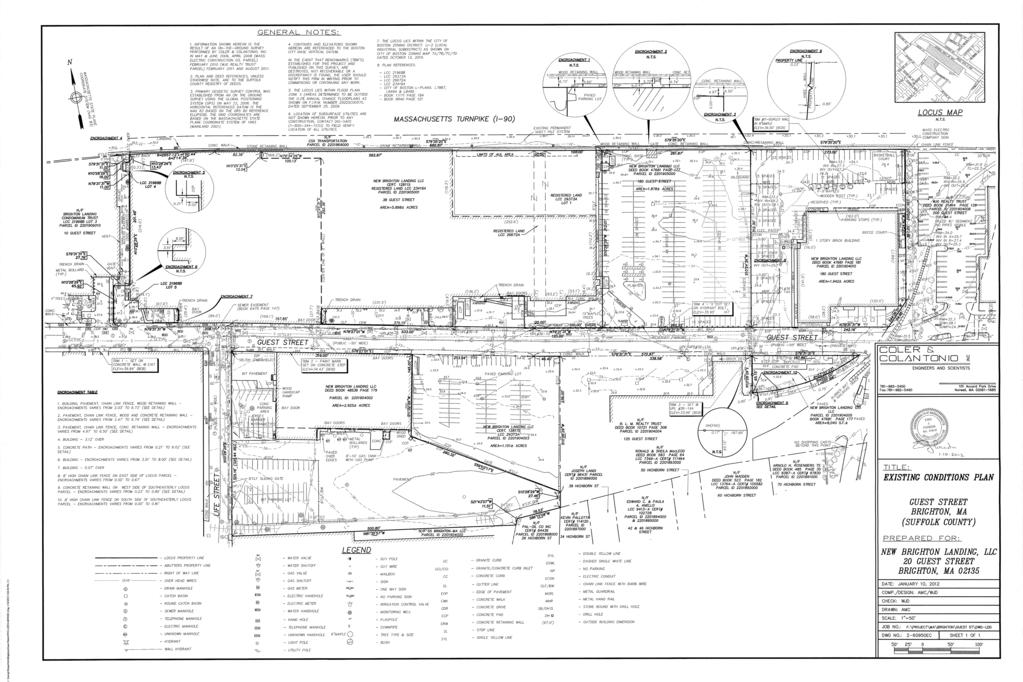
15 MASTER PLAN FOR PLANNED DEVELOPMENT AREA No. 87 NEW BRIGHTON LANDING GUEST STREET AND LIFE STREET BRIGHTON LANDING AREA OF BOSTON DATED: MARCH 20, The Master Plan. Pursuant to Section 3-1A and Article 80C of the Zoning Code of the City of Boston, Massachusetts, as amended (as so amended, the Zoning Code ), this plan constitutes a Master Plan (the Plan ) for Planned Development Area No. 87 for the development of approximately acres (about 608,969 square feet) of land known as and numbered Guest Street, 77 Guest Street, and two (2) vacant lots (the Vacant Lots ), all located in the Brighton Section of Boston, Massachusetts (such land, the New Brighton Landing ) Guest Street comprises about acres and is located on the northerly side of Guest Street, and 77 Guest Street and the Vacant Lots comprise about acres and are located on the southerly side of Guest Street and the easterly side of Life Street. The entirety of New Brighton Landing is located within the Planned Development Area to be governed by this Plan. New Brighton Landing is legally described in Exhibit A attached hereto. This Plan contemplates that one or more Planned Development Area Development Plans (as defined in the Zoning Code); each such plan, a PDA Development Plan will be submitted to provide more specific information about various proposed projects (as defined in the Zoning Code) and components thereof. New Brighton Landing is shown on the plan dated January 10, 2012 entitled Existing Conditions Plan Guest Street Brighton, MA (Suffolk County), prepared by Coler & Colantonio, Inc., a copy of which is attached hereto as Exhibit C (the Survey ). An existing site plan of New Brighton Landing is shown on Exhibit B attached hereto. This Plan consists of 7 pages of text, plus the attachments designated as Exhibit A through Exhibit E. All references herein to this Plan refer to such pages and exhibits. Capitalized terms used but not defined in this Plan shall be as defined in Article 2A of the Zoning Code as in effect on the date hereof, and not as amended hereafter. This Plan describes four new projects (each, a Proposed Project, and collectively, the Proposed Projects ) to be located on the site: (i) a new Office Use building with accessory parking to house New Balance employees, managers and officers, together with Retail Use, Restaurant Use and Service Use (the New Balance World Headquarters Project ); (ii) a new Office Use building or buildings with accessory parking, Restaurant Use, Retail Use, and Service Use (the Office Buildings Project ); (iii) a Hotel Use with accessory parking, Restaurant Use, LIBD/
16 Retail Use, and Service Use (the Hotel Project ); and (iv) a sports facility with accessory parking, Restaurant Use, Retail Use, and Service Use (the Sports Facility Project ). Each of the Proposed Projects is discussed below. This Plan sets forth the proposed location and range of dimensions of the structures to be constructed, the proposed uses and range of densities of the Proposed Projects, and the anticipated public benefits of the Proposed Projects. This Plan also describes the planning objectives and character of the Proposed Projects. A conceptual site plan of the Proposed Projects is shown on Exhibit D attached hereto. 2. The Developer / Proponent. New Brighton Landing LLC, (the Proponent or the Developer ), submits this Plan under Article 80C of the Zoning Code. The Developer is currently headquartered at 180 Guest Street in Brighton, Massachusetts which is located on the northerly side of Guest Street. The Proponent is a privately held Massachusetts entity, and will file a Statement of Beneficial Interests with the Boston Redevelopment Authority ( BRA ), the Zoning Commission and the Boston City Clerk, as required by Section 80B-8 of the Zoning Code. 3. The Project Site/PDA Area. New Brighton Landing consists of ten (10) parcels of land, comprising six (6) tax lots, and contains about acres (about 608,969 square feet) of land area located on both the north and south sides of Guest Street. Only a small 8,049 square foot parcel on the southerly side of Guest Street is not contiguous to any of the other parcels. The portion of New Brighton Landing on the northerly side of Guest Street is bounded to the north by land of the MBTA, to the south by Guest Street, to the east by a Stop & Shop Supermarket and to the west by the office complex known as Brighton Landing. The contiguous portion of New Brighton Landing on the southerly side of Guest Street is bounded to the north by Guest Street, to the south by numerous other property owners, to the east by land of Edward C. Joyce, Trustee/B.L. Makepeace, Inc., and to the west by Life Street, (collectively, the Project Site ), all as shown on Exhibit C attached hereto. Upon approval of this Plan, the entirety of New Brighton Landing will be located in the Planned Development Area governed by this Plan. The entirety of New Brighton Landing is owned by New Brighton Landing LLC, a Massachusetts limited liability company. The existing buildings on New Brighton Landing will be razed prior to or at such time as is necessary to allow construction of a Proposed Project to proceed. 4. The Proposed Projects. The Proponent proposes the construction of four (4) new building projects to enable the Proponent to create a new location for its headquarters, while at the same time creating other uses complimentary and compatible to the neighborhood fabric in which it is located. The four (4) Proposed Projects are described conceptually below. (a) New Balance World Headquarters Project. The New Balance World Headquarters Project entails the construction of a new office building, with accessory parking and loading, which may also contain uses such as Restaurant Use, Retail Use and Service Use, containing approximately 250,000 square feet, exclusive of areas dedicated for parking at or above grade and loading, and exclusive of areas devoted to Restaurant Use, Retail Use and Service Use. The New Balance World Headquarters Project will be occupied by New Balance LIBD/
17 Athletic Shoe, Inc. ( New Balance ) for its world headquarters. Currently, this Proposed Project is contemplated to be located on the northerly side of Guest Street and on the most easterly portion of New Brighton Landing. (b) Hotel Project. The Hotel Project entails the construction of a building for hotel use, with accessory parking and loading, which may also contain other uses and amenities such as Restaurant Use, Retail Use and Service Use. This Project is expected to comprise about 175 hotel rooms and suites in an approximately 140,000 square foot building, exclusive of areas dedicated for parking at or above grade and loading, and exclusive of areas devoted to Restaurant Use, Retail Use and Service Use. Currently, this Proposed Project is contemplated to be located southerly of and next to the New Balance World Headquarters Project. (c) Office Buildings Project. The Office Buildings Project entails the construction of one or more buildings for office use, with accessory parking and loading, containing, in the aggregate, approximately 650,000 square feet, exclusive of areas dedicated for parking at or above grade and loading and exclusive of areas devoted to Retail Use, Restaurant Use and Service Use. This Proposed Project is contemplated to be located westerly of the New Balance World Headquarters Project and the Hotel Project. (d) Sports Facility Project. The Sports Facility Project entails the construction of a new building, with accessory parking and loading, on the southerly side of Guest Street to house a variety of sports activities. The Sports Facility may contain venues for basketball, tennis, ice hockey, general recreation, track and field, and a fitness/health and wellness facility. In addition, this Project may also contain Office Uses, Restaurant Use, Retail Use and Service Use. This Project is expected to comprise about 345,000 square feet, exclusive of areas dedicated for parking at or above grade and loading, and exclusive of areas devoted to Restaurant Use, Retail Use and Service Use. 5. General Description of Proposed Projects and Use Allocation. Each use which currently exists on New Brighton Landing will be discontinued prior to the commencement of construction of the Proposed Project that will replace each particular use. This Plan seeks approval, as discussed in Section 6 below, for the uses contemplated by the four (4) Proposed Projects, being Office Uses, Hotel Use, Sports Facility Use, Retail Use, Restaurant Use and Service Use, together with customary accessory uses (e.g., Auditorium Use, Museum Use, Outdoor Recreational Skating Use and Outdoor Café/ Dining Use), parking and loading. 6. Zoning. New Brighton Landing is located within the Guest Street Local Industrial Subdistrict, which is governed by Article 51 of the Zoning Code. There are no overlay districts applicable to the site. As shown on the Survey, Exhibit C, New Brighton Landing contains more than five (5) acres of land, and since it is not located in a residential zoning district, treating this submission as a Master Plan is authorized by Article 3-1A.a of the Zoning Code. This Plan sets forth the zoning for all Proposed Projects for the PDA Area. The Proponent acknowledges that all buildings, which are subject to Large Project Review under Article 80B of the Zoning Code, are subject to Article 37 of the Zoning Code regarding Green Buildings. To the extent that any of the Proposed Projects do not comply with the use, dimensional or other zoning regulations applicable thereto, this Plan seeks to supersede all such zoning requirements. The Proposed Projects will undergo review as required by Article 80 of the Zoning Code, as well LIBD/
18 as design review subsequent to the submission of one or more PDA Development Plans for the Proposed Projects. Review of environmental impacts will be accomplished during the Article 80 process, utilizing any studies previously performed. 7. Planning Objectives and Character of the Development. The Proposed Projects comprise a mixed-use development encompassing acres (about 608,969 square feet) of land, adjacent to the existing New Balance World Headquarters Building at 20 Guest Street, along the Massachusetts Turnpike in the City of Boston s Brighton neighborhood. The Developer seeks to create a district, within a thriving Boston neighborhood, focused on job creation, health and wellness, significant sports and fitness opportunities, open space, and improvements to the public infrastructure. The acre site, adjacent to the existing New Balance headquarters, is currently occupied by buildings and surface parking lots that, at various times, supported industrial manufacturing, industrial offices, storage, and vehicle maintenance. For well over 100 years, the project site has been a job creator for area residents. From the cattle yards around the turn of the century into the industrial age, the area has been a place for agriculture, livestock and manufacturing, which served as the economic backbone for the neighborhood. The area s success was a result of its proximity to Boston s central business district, the city of Cambridge and rail service. In the 1960 s however, the area was dramatically changed with the creation of the Massachusetts Turnpike and the elimination of train service to the neighborhood. The Proponent seeks to provide thousands of employment opportunities, first-class sporting and fitness facilities, diverse retail, significant open space, and improvements to the existing infrastructure. The Proponent celebrates the historic significance of the Brighton Stockyards and now seeks to create a neighborhood district focused on health and wellness. As shown on the Conceptual Site Plan of the Proposed Projects, attached as Exhibit D, the Proponent, with guidance from the Brighton/Guest Street Planning Study, has laid a new foundation for the vision of the Guest Street, Life Street and Arthur Street corridors, with a welldesigned and well-coordinated mix of buildings, uses and facilities, and with a generous supply of landscaped open space. 8. Range of Density and Dimensions of Proposed Improvements. The New Balance World Headquarters Project will contain approximately 250,000 square feet of Floor Area, Gross, exclusive of areas dedicated for Retail Use, Restaurant Use and Service Use, and parking at or above grade and loading, and will not exceed a Building Height of 130 feet. The Office Buildings Project will contain approximately 650,000 square feet of Floor Area, Gross, exclusive of areas dedicated to Retail Use, Restaurant Use and Service Use, and for parking at or above grade and loading, and will not exceed a Building Height of 165 feet. The Hotel Project will contain approximately 140,000 square feet of Floor Area, Gross, exclusive of areas dedicated for Retail Use, Restaurant Use and Service Use, and parking at or above grade and loading, will contain a maximum of 175 hotel rooms and suites, and will not exceed a Building Height of 205 feet. LIBD/
19 The Sports Facility Project will contain approximately 345,000 square feet of Floor Area, Gross, exclusive of areas dedicated for Retail Use, Restaurant Use and Service Use, and parking at or above grade and loading, and will not exceed a Building Height of 95 feet. The Retail Use, Service Use and Restaurant Use referenced above, which will be disbursed among the Proposed Projects, will contain, in the aggregate, approximately 65,000 square feet of Floor Area, Gross, exclusive of areas designated for accessory parking at or above grade and loading. Based upon a total estimated Floor Area, Gross of 1,450,000 square feet for the Proposed Projects and the Retail Use, Restaurant Use and Service Use, exclusive of at and above grade parking and loading, and approximately acres (approximately 608,969 square feet) of land comprising New Brighton Landing, the approximate Floor Area Ratio for the Proposed Projects is 2.38, with a maximum Floor Area Ratio of 2.50 at New Brighton Landing. 9. Range of Parking and Loading Facilities. While it is anticipated that there will be approximately 1,750 parking spaces to serve all 4 Proposed Projects, and adequate loading facilities will be provided, the number and location of the parking and loading components will be determined as part of the Article 80B, Large Project Review process. 10. Development Schedule and Phasing. It is anticipated that the Proposed Projects will be phased, subject to market considerations. It is the Proponent s desire to commence construction of one or more of the Proposed Projects not later than the spring of Open Space and Landscaping. Currently, the Guest Street and Life Street corridors are a sea of asphalt with outdated warehouse buildings. As is shown on Exhibit D, the Proposed Projects will be enhanced and beautified by a considerable amount of well-designed landscaped open space. New landscaped open space will transform these parcels from a sea of asphalt and warehouses into areas where the community can gather and enjoy the available amenities. 12. Traffic Study and Analysis. Attached hereto as Exhibit E is a transportation study of the Proposed Projects prepared by 13. Public Benefits. The Proposed Projects are expected to provide the following benefits, at a minimum: (a) Each of the Proposed Projects will have a design that responds favorably to each of the other Proposed Projects, as well as being sensitive and responsive to its surrounding context; (b) Each of the Proposed Projects will minimize environmental impacts, and will create considerably more usable open space than currently exists at New Brighton Landing; (c) The Proposed Projects will provide considerably more real estate tax revenue for the City of Boston; LIBD/
20 (d) The Proposed Projects will create better internal circulation in the immediate neighborhood and better access and egress from nearby streets; (e) The Sports Facility Project will provide opportunities for its use by the residential population; (f) The Proposed Projects include open space which will be available to the general public, and may include amenities such as an amphitheater and a recreational outdoor skating rink; (g) The Proposed Projects will generate substantial housing linkage funds and jobs linkage funds for the City of Boston; (h) The Proposed Projects will represent a more orderly and coordinated master development than could be accomplished by more than one developer of New Brighton Landing; (i) The Proposed Projects establish an anchor for renewed activity along the Guest Street and Life Street corridors; (j) The Proposed Projects will create new signature LEED-certifiable buildings along the spines of the Massachusetts Turnpike and Guest Street; (k) The Proposed Projects will create approximately 400 full-time construction jobs, approximately 600 peak construction jobs and approximately 3,000 permanent new jobs; (l) The Proposed Projects will expand the diversity of uses in the Brighton Landing area to insure long-term activity and vitality; and (m) The Proposed Projects will expand the critical mass of Class A space in the Brighton Landing area. 14. Other Approvals. The design of the Proposed Projects will be subject review by the Boston Civic Design Commission, and to further review by the BRA of the schematic design, design development and construction drawings, pursuant to the BRA s Development Review Guidelines and Article 80B of the Zoning Code. Aspects of the Proposed Projects may also require approvals of other governmental agencies, such as the City of Boston s Public Improvement Commission, Landmarks Commission, and Boston Zoning Commission. No permits for any Proposed Projects included in this Plan, as the same may be amended, shall be required from the Zoning Board of Appeals. 15. Effect of PDA Master Plan. This Plan sets forth the zoning for all of the Proposed Projects for New Brighton Landing. Upon approval by the BRA and the Boston Zoning Commission, any PDA Development Plan for a Proposed Project within New Brighton Landing that is consistent with this Plan will be presumed to be consistent with the underlying zoning requirements and all other requirements of the Zoning Code, to the extent that such requirements are made applicable and have been addressed by this Plan or a PDA Development LIBD/
21 Plan. New Brighton Landing consists of various legal lots, and in order to implement the Proposed Projects, new legal lots may be created and one or more may be leased or conveyed to third parties. Notwithstanding that legal lots may be in separate legal ownership and/or separated by streets, the dimensional requirements set forth in this Plan shall apply to New Brighton Landing as a whole and not to each individual lot, and a Certification of Consistency shall be issued for each separate building. Noncompliance of any building shall not affect compliance of any other building for which a Certificate of Consistency has been issued, or the right to construct any other building contemplated by this Plan. LIBD/
22 Exhibit A Legal Description of New Brighton Landing Guest Street Parcel 1 That certain parcel of land situated in that part of Boston formerly Brighton in the County of Suffolk, Commonwealth of Massachusetts, bounded and described as follows: SOUTHERLY WESTERLY NORTHERLY EASTERLY by Buffalo Street, five hundred thirty-three (533) feet and by Guest Street, one hundred eighty and 32/100 (180.32) feet; by land now or formerly of Hathaway Bakeries, Inc., two hundred ninetysix and 83/100 (296.83) feet; and seven hundred thirteen and 34/100 (713.34) feet and three hundred eleven and 88/100 (311.88) feet by land now or formerly of the Boston & Albany Railroad Company. All of said boundaries are determined by the Court to be located as shown on a plan drawn by William S. Crocker, Civil Engineer, dated January 18, 1952, as modified and approved by the Court, filed in the Land Registration Office, as Plan No A, a copy of a portion of which is filed with Certificate of Title No Parcel 2 That certain parcel of land situated in that part of Boston formerly Brighton in the County of Suffolk, Commonwealth of Massachusetts, bounded and described as follows: SOUTHWESTERLY NORTHWESTERLY NORTHEASTERLY SOUTHEASTERLY by Guest Street, twenty (20) feet; by land now of formerly of Elm Farm Foods Co., three hundred eleven and 88/100 (311.88) feet; and twenty (20) feet, and three hundred eleven and 90/100 (311.90) feet by land now or formerly of the Boston and Albany Railroad Company. All of said boundaries are determined by the Court to be located as shown on a plan drawn by William S. Crocker, Civil Engineer, dated March 15, 1956, as modified and approved by the Court, filed in the Land Registration Office as plan No A, a copy of a portion of which is filed with Certificate of Title No LIBD/
23 Parcel 3 That certain parcel of land situated in that part of Boston formerly Brighton in the County of Suffolk, Commonwealth of Massachusetts, bounded and described as follows: SOUTHWESTERLY NORTHWESTERLY NORTHEASTERLY SOUTHEASTERLY by Guest Street, one hundred (100) feet; by land now or formerly of the Trustees of Richwood Trust, three hundred eleven and 90/100 (311.90) feet; and one hundred (100) feet, and three hundred twelve and 01/00 (312.01) feet by land now of formerly of the Boston and Albany Railroad Company. Said land is shown as lot 1 on the plan hereinafter mentioned. All of said boundaries are determined by the Court to be located as shown on a plan drawn by William S. Crocker, Inc., Civil Engineers, dated August 17, 1959, as modified and approved by the Court, filed in the Land Registration Office as Plan 29373A, a copy of a portion of which is filed with Certificate of Title No , and shown thereon as Lot 1. Parcel 4 That certain parcel of land situated in that part of Boston formerly Brighton in the County of Suffolk, Commonwealth of Massachusetts, bounded and described as follows: NORTHERLY EASTERLY SOUTHERLY WESTERLY by land now or formerly of Honeywell Information Systems Inc., twentyseven and seventy-nine hundredths (27.79) feet; by land now or formerly of the Trustees of the Richwood Trust, sixty-five and ninety-two hundredths (65.92) feet; by the Northerly line of Guest Street, twenty-seven and seventy-nine hundredths (27.79) feet; and by land now or formerly of Honeywell Information Systems Inc., sixtyfive and ninety-two hundredths (65.92) feet; Being shown as Lot 5 as shown on a plan entitled PLAN OF LAND BOSTON (BRIGHTON) MASS. BEING A SUBDIVISION OF LAND SHOWN ON LAND COURT PLAN 21968A AS LOT 1, scale 1 = 40, May 31, 1984 and revised September 14, 1984, Harry R. Feldman, Inc., Land Surveyors, and recorded with Certificate of Title No as Plan 21968B. LIBD/
24 Parcel 5 That certain parcel of land situated in that part of Boston formerly Brighton in the County of Suffolk, Commonwealth of Massachusetts, bounded and described as follows: NORTHERLY by land now or formerly of Honeywell Information Systems Inc., eleven (11) feet; EASTERLY by land now or formerly of the Trustees of Richwood Trust, sixteen (16) feet; SOUTHERLY WESTERLY by land now or formerly of Honeywell Information Systems Inc., eleven (11) feet; and by land now or formerly of Honeywell Information Systems Inc., sixteen (16) feet; Being shown as Lot 4 as shown on a plan entitled PLAN OF LAND BOSTON (BRIGHTON) MASS. BEING A SUBDIVISION OF LAND SHOWN ON LAND COURT PLAN 21968A AS LOT 1, scale 1 = 40, May 31, 1984 and revised September 14, 1984, Harry R. Feldman, Inc., Land Surveyors, and recorded with Certificate of Title No as Plan 21968B. Parcel 6 A certain parcel of land in that part of the City of Boston, County of Suffolk and said Commonwealth, known as Brighton, being shown as Lot 1 on a plan dated August 19, 1974, recorded with said Deeds at Book 8840, Page 121, bounded and described as follows: Beginning at a point on the northerly side of Guest Street, said point being a concrete monument feet easterly from the easterly sideline of Market Street; thence N E along the land of Gordon F. Bloom, et al, Trustees of Richwood Trust a distance of feet; thence S E along the southerly property line of the Penn Central Railroad a distance of feet; thence S W along the westerly property now or formerly of Gordon F. Bloom a distance of feet; and thence N W along the northerly sideline of Guest Street a distance of feet to the point of beginning. LIBD/
25 Parcel 7 The land in that part of the City of Boston, County of Suffolk, Commonwealth of Massachusetts, and any buildings and other improvements located therein, bounded and described as follows: Beginning at a point on the northerly side of Guest Street, said point being feet easterly from the easterly sideline of Market Street and feet easterly from a concrete monument along the northerly sideline of Guest Street; thence N E through the land now or formerly of Gordon F. Bloom, a distance of feet; thence S E along the southerly property line of Penn Central Railroad, a distance of feet; thence S W along land of Joseph T. Ryerson & Son, Inc., a distance of feet to a point; thence S W continuing along the property line of Joseph T. Ryerson & Son, Inc., a distance of feet to a point on the northerly sideline of Guest Street; and thence N W along the northerly sideline of Guest Street, a distance of feet to the point of beginning. Containing an area of 84,600 square feet (1.942 acres), more or less, as shown on a plan by Harry R. Feldman, Inc., dated August 19, 1974, which plan is recorded in the Suffolk County Registry of Deeds (the Registry ) in Book 8572, Page 685. Parcel 8 77 Guest Street A certain parcel of land situated in Brighton District of Boston, Suffolk County, Massachusetts, with the buildings thereon, now known and numbered as 77 Guest Street, bounded and described as follows: NORTHERLY: by Guest Street, feet; EASTERLY: by registered land now or formerly of Richwood Trust, feet; NORTHEASTERLY: by the same, feet; EASTERLY: by land now or formerly of The Clorox Company, feet; SOUTHERLY: feet by land now or formerly of The Clorox Company; EASTERLY: feet, by land now or formerly of The Clorox Company; SOUTHERLY: by land now or formerly of National Life Insurance Company, feet; and WESTERLY: by Life Street, feet. LIBD/
26 Parcel 9 VACANT LOTS That certain parcel of land situated in that part of Boston formerly Brighton in the County of Suffolk, Commonwealth of Massachusetts, bounded and described as follows: NORTHEASTERLY SOUTHEASTERLY SOUTHWESTERLY NORTHWESTERLY by Guest Street, two hundred fifty-nine and 93/100 (259.93) feet; by land now or formerly of Clorox Chemical Company, two hundred thirty-nine (239) feet; by other land now or formerly of the Boston and Albany Railroad Company, two hundred eighty and 32/100 (280.32) feet; and by land now or formerly of Schlitz Distributing Company of America, one hundred forty-five (145) feet. All of said boundaries are determined by the Court to be located as shown on a plan drawn by William S. Crocker Inc., Civil Engineers, dated August 17, 1959, as modified and approved by the Court, filed in the Land Registration Office as Plan No A, a copy of a portion of which is filed with Certificate of Title No , and shown thereon as Lot Two (2). Parcel 10 A certain parcel of land in that part of the City of Boston, County of Suffolk and said Commonwealth, known as Brighton, being shown as Parcel 2 on a plan recorded with said Deeds at Book 7614, Page 555, entitled New York Central System Land to be Conveyed by N.Y.C.R.R. Co. to Elm Farm Foods Co. at Brighton, dated , and being more particularly bounded and described as follows: Northerly by Guest Street, one hundred eighty-seven and eighty-nine hundredths feet ( ); Southerly by land now or formerly of the Clorox Chemical Co., two hundred one and sixty-four hundredths feet ( ); and Westerly by land now or formerly of said Clorox Chemical Co., sixty-five and fifteen hundredths feet (65.15 ). See also plan entitled Plan of Land Boston (Brighton), Mass. Scale : 1 = 20 dated May 17, 1984 by Harry R. Feldman, Inc., Land Surveyors, recorded with said Deeds at Book 11171, Page 184. LIBD/
27 Exhibit B Existing Site Plan LIBD/

28 Portsmouth Street South Waverly Street Litchfield Street Antwerp Street Lincoln Street Massachusetts Turnpike Market Street WGBH Current New Balance Parking Guest Street Stop & Shop Everett Street Life Street Hichborn Street Herrick Street Everett Street Glencoe Street Etna Street North Beacon Street New Brighton Landing Boston, Massachusetts New Brighton Landing, llc Exhibit B - Existing Site Plan Masterplan for PDA No. 87
29 Exhibit C Existing Conditions Survey LIBD/
30
31 Exhibit D Conceptual Site Plan of the Proposed Projects LIBD/

32 et rp Stre Litchfield A nt we Street treet South W averly S Street Por tsmouth Lincoln Street Massachusetts Turnpike Everett Street WGB H Current New Balance Stop & Shop e et Guest Street eac o n S treet Street Evere tt Herrick North B e et Street Street Hichborn Etna S tr Glenc oe Str e et Life Street Mark et S t r Parking 0 New Brighton Landing Boston, Massachusetts New Brighton Landing, llc Exhibit D - Conceptual Site Plan Masterplan for PDA No. 87
33 Exhibit E Transportation Study of Proposed Projects LIBD/
34 Exhibit E Transportation Study New Brighton Landing Master Plan for Planned Development Area #87 Submitted Pursuant to Article 80 of the Boston Zoning Code Prepared for New Brighton Landing, LLC Prepared by March 20, 2012 CREATIVE SOLUTIONS EFFECTIVE PARTNERING
35 Table of Contents 1.0 Introduction Project Description and Planning Area Methodology Study Area Existing Transportation Conditions Existing Roadway Conditions Existing Intersection Conditions Signalized Intersections Unsignalized Intersections Existing Traffic Volumes Crash Data Existing Traffic Operations Parking Public Transportation MBTA Bus Service Private Shuttles Commuter Rail Local Impacts of MBTA Budget Issues Pedestrian and Bicycle Facilities Loading and Service Year 2014 with Baseline Improvements Year 2014 No-Build Volumes Baseline Improvements Year 2014 No-Build Conditions with Baseline Improvements Year 2017 Conditions Year 2017 No-Build Conditions Year 2017 No-Build Traffic Operations Year 2017 No-Build Public Transportation Year 2017 No-Build Pedestrian and Bicycle Conditions Year 2017 Full-Build Conditions Site Access and Circulation Trip Distribution Trip Generation Pass -by and Internal Trips Travel Mode Shares Year 2017 Full-Build Conditions Traffic Operations Full-Build Conditions Parking Full-Build Conditions Public Transportation Full-Build Conditions Pedestrian and Bicycle Conditions Full-Build Conditions Loading and Service Accommodations...63 Master Plan PDA Transportation Component i New Brighton Landing
36 5.0 Transportation Mitigation Measures Intersection and Roadway Improvements Project Mitigation Recommendations from City s Guest Street Study Transit Mitigation Pedestrian and Bicycle Mitigation Travel Demand Management Measures...77 Master Plan PDA Transportation Component ii New Brighton Landing
37 List of Figures Figure 1 Locus Map... 2 Figure 2 Study Area Intersections... 6 Figure 3 Curbside Regulations...24 Figure 4 Public Transportation in the Study Area...26 Figure 5 Site Plan...42 Figure 6 Regional Trip Distribution Office Trips...43 Figure 7 Regional Trip Distribution - Hotel Trips...44 Figure 8 Regional Trip Distribution - Sports Complex/Retail...45 Master Plan PDA Transportation Component iii New Brighton Landing
38 List of Tables Table 1 New Brighton Landing Development Program... 3 Table 2 Level of Service Criteria (HCM Excerpt )...18 Table 3 Existing Conditions (2012) Peak Hour Level of Service Summary...20 Table 3 Existing Conditions (2012) Peak Hour Level of Service Summary (cont d)...21 Table 3 Existing Conditions (2012) Peak Hour Level of Service Summary (cont d)...22 Table 4 Existing Parking Spaces...23 Table 5 Public Transportation in the Study Area...24 Table 6 MBTA Proposed Budget Scenarios...28 Table 7 Baseline Improvements...32 Table 8 Table 8 Table 8 Table 9 Table 9 Table 9 Table 10 Year 2014 No-Build with Baseline Improvement Conditions Peak Hour Level of Service Summary...34 Year 2014 No-Build with Baseline Improvement Conditions Peak Hour Level of Service Summary (cont d)...35 Year 2014 No-Build with Baseline Improvement Conditions Peak Hour Level of Service Summary (cont d)...36 Year 2017 No-Build with Baseline Improvement Conditions Peak Hour Level of Service Summary...38 Year 2017 No-Build with Baseline Improvement Conditions Peak Hour Level of Service Summary (cont d)...39 Year 2017 No-Build with Baseline Improvement Conditions Peak Hour Level of Service Summary (cont d)...40 Travel Mode Shares...49 Table 11 Project Vehicle Trips by Land Use Full-Build...50 Table 12 Net New Peak Hour Vehicle Trip Generation Full-Build...50 Table 13 Table 13 Table 13 Table 13 Year 2017 Full-Build with Baseline Improvement Conditions Peak Hour Level of Service Summary...52 Year 2017 Full-Build with Baseline Improvement Conditions Peak Hour Level of Service Summary (cont d)...53 Year 2017 Full-Build with Baseline Improvement Conditions Peak Hour Level of Service Summary (cont d)...54 Year 2017 Full-Build with Baseline Improvement Conditions Peak Hour Level of Service Summary (cont d)...55 Master Plan PDA Transportation Component iv New Brighton Landing
39 Table 14 Block A and Block C Parking Garage Office, Hotel and Retail/Restaurant Uses..58 Table 15 Saturday Parking Demand for Sports Complex Events...60 Table 16 Project Transit Trips by Land Use Full-Build...61 Table 17 Net New Peak Hour Transit Vehicle Trip Generation Full-Build...61 Table 18 Project Walk/Bike Trips by Land Use Full-Build...62 Table 19 Net New Peak Hour Walk/Bike Trip Generation Full-Build...62 Table 20 Summary of Anticipated Delivery Activity by Land Use...64 Table 21 Year 2017 Full-Build with Mitigation Conditions Peak Hour Level of Service Summary...71 Table 21 Year 2017 Full-Build with Mitigation Conditions Peak Hour Level of Service Summary (continued)...72 Table 21 Year 2017 Full-Build with Mitigation Conditions Peak Hour Level of Service Summary (cont d)...73 Table 21 Year 2017 Full-Build with Mitigation Conditions Peak Hour Level of Service Summary (cont d)...74 Table 22 Year 2017 Full-Build with Denby Street/Wilton Street Alternatives Peak Hour Level of Service Summary...74 Appendix A (bound separately) Intersection Volumes (Figures A1-A21) Crash Data Detailed Level of Service Tables Synchro Reports Trip Generation Master Plan PDA Transportation Component v New Brighton Landing
40 1.0 INTRODUCTION This study presents existing and future transportation conditions associated with the proposed New Brighton Landing (the Project), to be located on Guest Street in the Brighton neighborhood of Boston, Massachusetts. New Brighton Landing, LLC, (the Proponent) hopes to create a health and wellness district with a new mixed-use development anchored by the New Balance World Headquarters, a sports complex housing a hockey rink, track and field facilities, and a state of the art fitness club. In total, the Project will have approximately 1.4 million square feet, with much of the land use devoted to office, sports, and health-related businesses and activities. An in-depth transportation study such as presented here, typically does not accompany the submission of a Planned Development Area (PDA) Master Plan, but is usually completed later in the permitting process. The Boston Redevelopment Authority (BRA), however, requested that the Proponent provide a detailed evaluation of the Project s transportation impacts with submission of this PDA, prior to the Project Notification Form (PNF). 1.1 Project Description and Planning Area As shown in Figure 1, the acre Project site is adjacent to New Balance headquarters at 20 Guest Street, straddles Guest Street, and includes parcels currently known as 77 Guest Street (south side) and Guest Street (north side). Collectively, the parcels currently contain low-rise office space and various, low density industrial and warehouse buildings, some of which are vacant. The Project s development program, as shown in Table 1 will include a new world headquarters office building for New Balance, one or more separate general office buildings, and a hotel. The sports complex will include a hockey rink, track and field facilities, a fitness club and a medical office. Many supporting retail and restaurant establishments will be located throughout the Project, primarily at street level on Guest Street. Phased construction of the Project is expected to begin in As part of this Project, New Balance will vacate their existing office space at 20 Guest Street, although the space will eventually be leased by new tenants. Master Plan PDA Transportation Component 1 New Brighton Landing
41 Not to scale. SITE New Brighton Landing Figure 1. Locus Map
42 Figure 1 Locus Map Master Plan PDA Transportation Component 2 New Brighton Landing
43 Table 1 New Brighton Landing Development Program Land Use Office New Balance World Headquarters Other Office Sports Complex Hockey Facility Track and Field Facility Fitness Club Medical Office Hotel Year 2017 Full-Build 250,000 sf 650,000 sf 125,000 sf 85,000 sf 83,000 sf 30,000 sf 175 rooms Retail/Restaurant 65,000 sf Parking Spaces 1) up to 1,750 spaces 1) The Project s parking supply will be located in two garages. One garage, with about 1,550 spaces, will be located on the north side of Guest Street, contiguously under several Project buildings. The second garage, with about 200 spaces, will be located under the sports complex on the south side of Guest Street. The Project site is at the heart of a larger 100-acre district recently examined in the City s Brighton/Guest Street Area Planning Study 1. The study establishes urban design guidelines that will help shape future development in this area of Brighton, focusing on creating a unique identity for the area through a blend of pedestrian scaled streets, public parks and plazas, and neighborhood amenities. Many of the recommended short-term and long-term transportation improvements in the study are supported by the Proponent and have been incorporated into the Project s proposed mitigation measures, as presented in Section Methodology In accordance with the City of Boston s Transportation Access Plan Guidelines (2001) and the BRA Development Review Guidelines (2006), this report describes roadway, pedestrian, and bicycle conditions; transportation issues; parking and loading; and transportation goals for the proposed Project. Although the Boston Transportation Department (BTD) has not yet issued a formal Transportation Access Plan Scope, this report adheres to the general format requested by BTD. Section 2.0 includes an inventory of existing (Year 2012) transportation conditions, with roadway capacities, parking, transit, and bicycle and pedestrian conditions. 1 Brighton/Guest Street Area Planning Study, Final Report, prepared for the Boston Redevelopment Authority by Sasaki Associates and GLC Development Resources. February Master Plan PDA Transportation Component 3 New Brighton Landing
44 The Proponent is committed to improving existing traffic conditions in the area independent of any new development. Anticipating that these improvements can be implemented in the short-term, the study team assessed Year 2014 conditions with the integration of Baseline Improvements, as summarized in Section 3.0. The Proponent, who has already held preliminary meetings with the BTD staff, will continue to work collaboratively with the City to support implementation of these improvements. Long-term impacts are evaluated for Year 2017, based on a five-year horizon from the existing year (2012). Expected roadway, parking, transit, bicycle and pedestrian conditions are identified. No-Build conditions, which include general background growth and additional vehicular traffic associated with specific planned developments near the Project site, are presented in Section 4.1. Full-Build conditions, which include specific travel demand forecasts for the Project, are presented in Section 4.2. Transportation mitigation measures are presented in Section Study Area The study area, coordinated with the BTD, comprises the following 30 intersections. The corresponding numbers are shown in Figure 2. The study area for the Saturday assessment, denoted by locations with an *, is a subset of 19 intersections more proximate to the Project site. New site driveways and new intersections created by the Project development or mitigation proposals are also analyzed and listed in the appropriate analysis section. 1. Western Avenue/Birmingham Parkway/Soldiers Field Road Ramps;* 2. Birmingham Parkway/the Soldiers Field Road Off-Ramp and Lathrop Street* 3. Birmingham Parkway/Market Street and Lincoln Street* 4. Market Street/Guest Street/Stockyard Restaurant Driveway* 5. Market Street/Vineland Street 6. Market Street/North Beacon Street* 7. North Beacon Street/Life Street/Etna Street* 8. North Beacon Street/Murdock Street/EZ Storage Driveway* 9. North Beacon Street/Dustin Street/Hichborn Street* 10. North Beacon Street/Arthur Street/Wingate Driveway* 11. North Beacon Street/Saunders Street* 12. North Beacon Street/Everett Street* 13. North Beacon Street//Brighton Avenue/Cambridge Street (Union Square)* 14. Cambridge Street/Denby Road 15. Cambridge Street/Harvard Avenue/Franklin Street* 16. Cambridge Street/Lincoln Street 17. Cambridge Street/North Harvard Street 18. Cambridge Street/Saunders Street* 19. Cambridge Street/Dustin Street Master Plan PDA Transportation Component 4 New Brighton Landing
45 20. Cambridge Street/Murdock Street 21. Washington Street/Market Street/Chestnut Hill Avenue 22. Market Street/Arlington Street/Sparhawk Street 23. Market Street/Faneuil Street* 24. Guest Street/Life Street* 25. Guest Street/Arthur Street/Stop & Shop Supermarket Driveway* 26. Everett Street/Stop & Shop Supermarket Driveway* 27. Everett Street Bridge/Everett Street local (north) 28. Everett Street/Holton Street 29. Western Avenue/Everett Street* 30. Braintree Street/Denby Road Master Plan PDA Transportation Component 5 New Brighton Landing
46 29 Not to scale SITE Signalized Unsignalized New Brighton Landing Figure 2. Study Area Intersections
47 Figure 2 Study Area Intersections Master Plan PDA Transportation Component 6 New Brighton Landing
48 2.0 EXISTING TRANSPORTATION CONDITIONS 2.1 Existing Roadway Conditions The study area includes the following roadways, which are categorized according to the Massachusetts Department of Transportation Office of Transportation Planning functional classifications: Market Street - Market Street is a two to four lane collector roadway that traverses the study area in a general northeast-southwest direction between Cambridge Street and Birmingham Parkway. Market Street provides two 11- to 13-foot wide travel lanes per direction between North Beacon Street and Birmingham Parkway. South of North Beacon Street, Market Street provides one 11- to 24-foot wide travel lane per direction, with additional turning lanes provided at major intersections. Sidewalks are provided continuously along both sides of Market Street, with crosswalks provided at signalized intersections. Land use along Market Street consists of a mix of commercial and residential properties. North Beacon Street - North Beacon Street is a two-lane collector roadway that traverses the study area in a general east-west direction between Goodenough Street and Cambridge Street. North Beacon Street provides two 11 to 29.5-foot wide travel lanes separated by a double-yellow centerline (one lane per direction), with additional turning lanes provided at major intersections. Sidewalks are provided continuously along both sides of North Beacon Street, with marked crosswalks provided at signalized intersections. Land use along North Beacon Street consists of a mix of commercial, industrial and residential properties. Cambridge Street - Cambridge Street is a four to six lane collector roadway that traverses the study area in a general northeast-southwest direction between Washington Street and Soldiers Field Road. Cambridge Street provides access to Interstate 90 (I-90) by way of the Allston-Brighton interchange. Cambridge Street generally provides two 11- to 13-foot wide travel lanes per direction between Washington Street and Harvard Avenue/Franklin Street, and three to 16.5-foot wide travel lanes between Harvard Avenue/Franklin Street and Soldiers Field Road. Additional turning lanes are provided at major intersections. Sidewalks are provided continuously along both sides of Cambridge Street, with crosswalks provided at signalized intersections. Land use along Cambridge Street consists of a mix of commercial and residential properties. Western Avenue - Western Avenue is a two-lane collector roadway that traverses the study area in a general east-west direction between Soldiers Field Road and Arsenal Street/Birmingham Parkway. Within the study area, Western Avenue provides two 11- to 24.5 foot wide travel lanes separated by a double-yellow centerline (one lane per Master Plan PDA Transportation Component 7 New Brighton Landing
49 direction), with additional turning lanes provided at major intersections. Sidewalks are provided continuously along both sides of Western Avenue, with marked crosswalks provided at signalized intersections. Land use along Western Avenue consists primarily of commercial properties. Everett Street - Everett Street is a two-lane local roadway that traverses the study area in a general north-south direction between Beacon Street and Western Avenue. Everett Street provides two 13- to 14-foot wide travel lanes generally separated by a double-yellow centerline (one lane per direction). Sidewalks are generally provided along both sides of Everett Street, although sections between North Beacon Street and overpass have only narrow asphalt walkways with no curbs. Crosswalks provided at Western Avenue and North Beacon Street. Land use along Everett Street consists primarily of residential properties, with commercial properties located proximate to Western Avenue and the Stop & Shop Supermarket situated adjacent to I-90. Arthur Street Arthur Street is a two-lane local roadway that traverses the study area in a general north-south direction between North Beacon Street and Guest Street. Arthur Street varies in width from approximately 26 feet at its northern end to approximately 40 feet at the southern end. Where Arthur Street meets North Beacon Street, it includes three lanes, a northbound lane, a southbound right turn lane and a southbound left turn lane. Sidewalks are provided along both sides of Arthur Street with a crosswalk provided at the intersection with North Beacon Street. Land use along Arthur Street consists of commercial and retail properties including Wolfers Lighting, Hollywood Video, and Boston Volvo Village. Guest Street - Guest Street is a two-lane local roadway that traverses the study area in a general east-west direction between Market Street and Arthur Street/Stop & Shop Supermarket driveway. Guest Street is approximately 34 to 36 feet in width (paved area) and accommodates two-way travel. The eastern end of Guest Street and the Guest Street/Arthur Street intersection is a private-way that provides access to the Stop & Shop Supermarket, although there are no physical restrictions on access between Guest Street and Arthur Street. Substandard sidewalks are provided generally along both sides of Guest Street, with crosswalks provided at Market Street and proximate to WGBH/New Balance and the Stop & Shop Supermarket. Land use along Guest Street consists of commercial and industrial properties including WGBH, New Balance, Stop & Shop Supermarket, a parking garage, B. L. Makepeace, Mass Electric Construction Company, Crystal Transport and the project site. Life Street Life Street is a two-lane local roadway that traverses the study area in a general north-south direction between North Beacon Street and Guest Street. Life Street is approximately 35 feet wide. Sidewalks are generally provided on one side of Life Street with the side varying depending on location. Crosswalks are not provided at any point on Life Street. Land use along life Street consists of office, retail and fitness properties including a small office building, Bally Total Fitness and the New Balance Shoe Outlet store. Master Plan PDA Transportation Component 8 New Brighton Landing
50 2.2 Existing Intersection Conditions As a part of this assessment, the study area included all major intersections located within an approximate one-mile radius of the project, specifically 30 intersections located along Guest Street, Birmingham Parkway, Market Street, North Beacon Street, Cambridge Street, Western Avenue and Everett Street. This expansive study area allows for a full evaluation of the transportation system serving the Allston/Brighton neighborhoods, both at present and with planned future development in the area. Further, the extent of the study area allows for the development of a neighborhood-focused transportation improvement program that is designed to incorporate a balanced approach to improving traffic flow, public transportation access, and accessibility for pedestrians and bicyclists Signalized Intersections Western Avenue/ Birmingham Parkway/Soldiers Field Road Ramps is a group of three interconnected, adjacent, signalized intersections. Western Avenue is intersected from the north by the Soldiers Field Road eastbound on-ramp and from the south by Birmingham Parkway to form the eastern intersection. The Western Avenue eastbound approach to this intersection consists of one 10.5-foot wide left-turn lane and two 10- to 10.5-foot wide general-purpose travel lanes. The Western Avenue westbound approach consists of one 11-foot wide left-turn lane and two 11-foot wide general-purpose travel lanes. The Birmingham Parkway northbound approach consists of a 10-foot wide left-turn lane, an 11.5-foot wide shared left-turn/through lane, a 12-foot wide through lane, and a 20-foot wide right-turn lane. The Soldiers Field Road eastbound on-ramp consists of a 21-foot wide roadway accommodating northbound vehicles only (vehicles exiting the intersection). The middle intersection consists of Arsenal Street, Western Avenue and the Soldiers Field Road westbound off-ramp. The Arsenal Street eastbound approach to this intersection consists of two 8.5- to 17-foot wide general-purpose travel lanes. The Western Avenue westbound approach consists of three 10- to 11-foot wide through lanes. The Soldiers Field Road westbound off-ramp southbound approach consists of an 11-foot wide through lane and a 10-foot wide shared through/right-turn lane. The western intersection consists of Arsenal Street and the Soldiers Field Road westbound ramps. The Arsenal Street eastbound approach consists of one 11-foot wide through lane and one 10.5-foot wide shared through/right-turn lane. Right turns enter the Soldiers Field Road westbound on-ramp by way of a 17-foot wide, channelized, right-turn slip ramp. The Arsenal Street westbound approach consists of a 10-foot wide left-turn lane and two 11-foot wide through lanes. The Soldiers Field Road westbound off-ramp southbound approach consists of an 11.5-foot wide shared through/right-turn lane and an 11.5-foot wide right-turn lane. The Soldiers Field Road on-ramp consists of a 24-foot wide roadway that accommodates southbound vehicles only. Trucks and buses are prohibited from accessing Soldiers Field Road. Sidewalks are provided along both sides of Western Avenue and Arsenal Street; along the Master Plan PDA Transportation Component 9 New Brighton Landing
51 east side of Birmingham Parkway and the Soldiers Field Road eastbound on-ramp; and along the west side of the Soldiers Field Road westbound on and off-ramps. A marked crosswalk is provided across the western leg of Arsenal Street. Birmingham Parkway/ Soldiers Field Road Off-Ramp/Lothrop Street is a signalized intersection with four approaches. The Birmingham Parkway northbound approach consists of four 10- to 12-foot wide through lanes. The Birmingham Parkway southbound approach consists of two 11-foot wide through lanes. The Soldiers Field Road off-ramp eastbound approach consists of two 13-foot wide left-turn lanes. Right turns exit the Soldiers Field Road off-ramp prior to the intersection by way of a 23-foot wide, channelized, right-turn slip-ramp. The Soldiers Field Road off-ramp accommodates eastbound vehicles only (vehicles entering the intersection). The Lothrop Street westbound approach consists of one 17-foot wide general purpose travel lane. Lothrop Street is a oneway roadway accommodating westbound vehicles only (vehicles entering the intersection). Sidewalks are provided along the east side of Birmingham Parkway; along the west side of Birmingham Parkway south of the Soldiers Field Road off-ramp; along both sides of Lothrop Street; and along the south side of the Soldiers Field Road off-ramp. Crosswalks are not provided at the intersection. An MBTA bus stop is located along the east side of Birmingham Parkway, south of Lothrop Street. Birmingham Parkway/Market Street/Lincoln Street is a signalized intersection with four approaches. The Market Street northbound approach consists of two 12-foot wide general purpose travel lanes. The Birmingham Parkway southbound approach consists of two 11- feet wide through travel lanes and one 9-foot wide right-turn lane. The Birmingham Parkway eastbound approach consists of two 13-foot wide general-purpose travel lanes. The Lincoln Street westbound approach consists of one 15-foot wide left-turn lane and one 15-foot wide general-purpose travel lane. Lincoln Street is a one-way roadway accommodating westbound traffic only (vehicles entering the intersection). Sidewalks are provided along the east side of Market Street, along the west side of Market Street south of Birmingham Parkway; and along both sides of Lincoln Street. A marked crosswalk is provided across the south leg of Market Street and along the Lincoln Street leg of the intersection. Market Street/ Guest Street/Stockyard Restaurant Driveway is a signalized intersection with four approaches. The Market Street north and southbound approaches consist of two 11- to 12.5-foot wide general purpose travel lanes. The Stockyard Restaurant driveway eastbound approach consists of a 12.5-foot wide general-purpose lane. The Guest Street westbound approach consists of an 11-foot wide shared left-turn/through lane and an 11- foot wide right-turn lane. Sidewalks are provided along both sides of Market Street and Guest Street. A marked crosswalk is provided across the south leg of Market Street and the Guest Street leg of the intersection. An MBTA bus stop and bus shelter is located on the east side of Market Street, south of Guest Street. A drop-off area* with a 5-minute time limit is provided on the south side of Guest Street for the WGBH studios. No Stopping Master Plan PDA Transportation Component 10 New Brighton Landing
52 Any Time signs are posted along both sides of Market Street and along the north side of Guest Street. Market Street/North Beacon Street is a signalized intersection with four approaches. The Market Street north and southbound approaches consist of two 11- to 14-foot wide general purpose travel lanes. The North Beacon Street east and westbound approaches consist of two 10-foot wide general purpose travel lanes. Sidewalks are provided along both sides of the intersecting roadways, with marked crosswalks provided across all legs of the intersection. No Stopping Any Time signs are posted along both sides of Market Street and North Beacon Street. MBTA bus stops are located on the northwest and southeast corners of Market Street and on the northeast corner of North Beacon Street, with a bus shelter provided at the North Beacon Street stop. North Beacon Street/Life Street/Etna Street is a signalized intersection with offset approaches on Life Street and Etna Street. The North Beacon Street east and westbound approaches consist of a 20-foot wide general purpose travel lane. The Life Street southbound approach consists of an 18-foot wide general purpose travel lane. The Etna Street south leg of the intersection is off-set slightly to the west of Life Street and consists of a 25.5-foot wide paved roadway that accommodates one-way southbound travel. On street parking is permitted along the south side of North Beacon Street. Sidewalks are provided along both sides of the intersecting roadways, with a marked crosswalk provided across North Beacon Street, between Etna Street and Life Street. An MBTA bus stop is located on the south side of North Beacon Street, west of Etna Street, with a bus shelter provided. North Beacon Street/ Arthur Street/Wingate Driveway is a signalized intersection with offset approaches on Arthur Street and the Wingate driveway. The North Beacon Street east and westbound approaches consist of a 20-foot wide general purpose travel lane. The Arthur Street southbound approach consists of 12-foot wide left and right-turn lanes. No Stopping Any Time signs are posted along both sides of North Beacon Street and Arthur Street. The Wingate at Brighton driveway is off-set slightly to the east of Arthur Street and accommodates two-way travel. Sidewalks are provided along both sides of North Beacon Street and Arthur Street. A marked crosswalk is provided across the west leg of North Beacon Street and across Arthur Street. North Beacon Street/Everett Street is a signalized intersection with three approaches, although a commercial driveway curb cut is located along the southern curb for entering vehicles only. The North Beacon Street east and westbound approaches consist of a 20- foot wide general purpose travel lane. Everett Street consists of a 27.5-foot wide paved roadway that accommodates two-way travel. Right-Turns-On-Red are prohibited from Everett Street. Parking is permitted along the north side of North Beacon Street except on weekdays between 4:00 and 6:00 PM. A No Parking, Tow Zone sign is posted on the east side of Everett Street. The KFC driveway accommodates vehicles entering the KFC parking lot (away from North Beacon Street). Sidewalks are provided along both sides of Master Plan PDA Transportation Component 11 New Brighton Landing
53 North Beacon Street and Everett Street. A marked crosswalk is provided across the west leg of North Beacon Street. North Beacon Street/Brighton Avenue/Cambridge Street (Union Sq.) is a signalized intersection with four approaches. The Brighton Avenue eastbound approach consists of two 11-foot wide left-turn lanes and one 11-foot wide general purpose travel lane. Rightturns exit the Brighton Avenue approach prior to the intersection by way of an 11-foot wide, channelized, right-turn slip-ramp. The North Beacon Street westbound approach consists of two 11-foot wide general purpose travel lanes. No Stopping Any Time signs are posted along the south side of North Beacon Street and Brighton Avenue. A No Parking 4:00 to 6:00 PM except Saturday and Sunday sign is posted on the north side of North Beacon Street. The Cambridge Street northbound approach consists of two 11-feet wide through travel lanes and one 10-foot wide right-turn lane. Left turns are prohibited from the Cambridge Street northbound approach. The Cambridge Street southbound approach consists of two 11- to 12-foot wide general purpose travel lanes, with a 9-foot wide on-street parking lane provided parallel to the curb. South of North Beacon Street, on-street parking with a 30 minute limit is permitted along the west side of Cambridge Street. Sidewalks are provided along both sides of North Beacon Street, Brighton Avenue, and Cambridge Street, north of North Beacon Street; and along the west side of Cambridge Street, south of North Beacon Street. Marked crosswalks are provided across all legs of the intersection. Cambridge Street/ Harvard Avenue/Franklin Street is a signalized intersection with four approaches. The Cambridge Street eastbound approach consists of two 11- to 13-foot wide general purpose travel lanes. The Cambridge Street westbound approach consists of two 10.5-foot wide general purpose travel lanes and a 14-foot wide right-turn lane. The Harvard Avenue northbound approach consists of one 22-foot wide general purpose travel lane that functions as a two-lane approach providing a general purpose travel lane and a right-turn lane. On-street parking is permitted along the west side of Harvard Avenue, with a two-hour parking limit on weekdays between 8:00 AM and 6:00 PM. Franklin Street consists of a 29.5-foot wide paved roadway accommodating two-way travel. On-street parking is permitted along Franklin Street, with a two-hour parking limit on weekdays between 8:00 AM and 6:00 PM. Sidewalks are provided along both sides of Cambridge Street, Harvard Avenue, and Franklin Street. Marked crosswalks are provided across all legs of the intersection. No-Turn-On-Red signs are posted on all approaches to the intersection. An MBTA bus stop is located on the north side of Cambridge Street, east of Franklin Street. Cambridge Street/Lincoln Street is a signalized intersection with four approaches. The Cambridge Street east and westbound approaches consist of a 9.5- to 10-foot wide left-turn lane and three to 12-foot wide general purpose travel lanes. The commercial driveway consists of a 34-foot wide paved driveway accommodating both entering and exiting vehicles. The Lincoln Street southbound approach consists of one 24-foot wide Master Plan PDA Transportation Component 12 New Brighton Landing
54 general-purpose travel lane. Sidewalks are provided along both sides of Cambridge Street and Lincoln Street. A marked crosswalk is provided across Lincoln Street and the east leg of Cambridge Street. Cambridge Street/North Harvard Street is a signalized intersection with four approaches. The Cambridge Street eastbound approach consists of an 11-foot wide left-turn lane and three to 11-foot wide general purpose travel lanes. The Cambridge Street westbound approach consists of one 10.5-foot wide left-turn lane, two 11-feet wide through travel lanes, and one 11.5-foot wide right-turn lane. The North Harvard Street southbound approach consists of one 23-foot wide general purpose travel lane. A No Stopping Any Time sign is posted along the west side of North Harvard Street. On-street, 15-minute parking is permitted along the north side of Cambridge Street, west of North Harvard Street. Sidewalks are provided along both sides of Cambridge Street and North Harvard Street. A marked crosswalk is provided across North Harvard Street, the Harvard University driveway, and the west leg of Cambridge Street. An MBTA bus stop is located on the south side of Cambridge Street, west of the Harvard University driveway. Cambridge Street/Dustin Street is a pedestrian actuated intersection with three approaches. The Cambridge Street eastbound approach consists of one 10.5-foot wide left-turn lane and one 20-foot wide general-purpose travel lane. The Cambridge Street westbound approaches consist of one 25-foot wide general-purpose travel lane. Dustin Street consists of a 25.5-foot wide paved roadway that accommodates one-way northbound travel (away from Cambridge Street). Sidewalks are provided along both sides of Cambridge Street and Dustin Street. A marked crosswalk is provided across Dustin Street and the east leg of Cambridge Street. MBTA bus stops are located on the north side of Cambridge Street, east of Dustin Street, and on the south side of Cambridge Street, west of Dustin Street. A bus shelter is provided on the south side of Cambridge Street, west of Dustin Street. On-street parking is permitted along Cambridge Street. Washington Street/ Market Street/Chestnut Hill Avenue is a signalized intersection with four approaches. The Washington Street east and westbound approaches consist of a 25- foot wide general purpose travel lane, with on-street parking permitted. The Chestnut Hill Avenue northbound approach consists of a 21-foot wide general purpose travel lane. The Market Street southbound approach consists of an 11.5-foot wide left-turn lane, an 11-foot wide through travel lane, and a 17.5-foot wide channelized right-turn lane. On-street parking is permitted along both sides of Washington Street and Market Street, with a twohour parking limit on weekdays between 8:00 AM and 6:00 PM. The on-street parking along the south side of the east leg of Washington Street is restricted to commercial vehicles only between the hours of 8:00 AM and 12:00 noon, Monday through Saturday. No-Turn-On-Red signs are posted on all approaches of the intersection. Sidewalks are provided along both sides of the intersecting roadways, with marked crosswalks provided across all legs of the intersection. MBTA bus stops (two) are located on the northeast corner of Washington Street and Market Street.. Master Plan PDA Transportation Component 13 New Brighton Landing
55 Market Street/ Arlington Street/Sparhawk Street is a signalized intersection with four approaches. The Market Street north and southbound approaches consist of a 21- to 23- foot wide general purpose travel lane. The Arlington Street eastbound approach consists of a 17-foot wide general purpose travel lane. The Sparhawk Street east leg of the intersection consists of a 26-foot wide paved roadway that accommodates two-way travel. No-Turn- On-Red signs are posted on the Market Street northbound approach and the Arlington Street westbound approach to the intersection. Trucks over 2 ½ tons are prohibited from Arlington Street. Sidewalks are provided along both sides of the intersecting roadways, with marked crosswalks provided across all legs of the intersection. MBTA bus stops are located on the east and west side of Market Street, south of Arlington Street and Sparhawk Street. Market Street/Faneuil Street is a signalized intersection with three approaches. The Market Street northbound approach consists of a 23-foot wide general purpose travel lane. The Market Street southbound approach consists of an 11-foot wide general-purpose travel lane and an 11-foot wide right-turn lane. The Faneuil Street eastbound approach consists of an 18-foot wide general purpose travel lane. Sidewalks are provided along both sides of the intersecting roadways, with marked crosswalks provided across all legs of the intersection. Western Avenue/Everett Street is a signalized intersection with four approaches. The Western Avenue eastbound approach consists of two 11- to 14-foot wide general-purpose travel lanes. The Western Avenue westbound approach consists of one 21.5-foot wide general-purpose travel lane. The Everett Street northbound approach consists of one foot wide general-purpose travel lane. The Everett Street southbound approach consists of one 13-foot wide general-purpose travel lane. Sidewalks are provided along both sides of Western Avenue and Everett Street. Marked crosswalks are provided across all legs of the intersection. An MBTA bus stop and bus shelter are located on the north side of Western Avenue, west of Everett Street. No Stopping Any Time signs are posted on the north and south sides of Western Avenue, west of Everett Street, and on the east side of Everett Street, south of Western Avenue. Right-Turns-On-Red are prohibited from the Everett Street north and southbound approaches, and from the Western Avenue eastbound approach Unsignalized Intersections Market Street/Vineland Street is an unsignalized intersection with three approaches. The Market Street north and southbound approaches consist of two 11- to 12-foot wide through travel lanes. Vineland Street consists of a 26-foot wide paved roadway that accommodates one-way eastbound travel, with vehicles approaching Market Street under STOP-sign control. No Stopping Any Time signs are posted along both sides of Market Street. Twohour parking is permitted along the south side of Vineland Street. Sidewalks are provided along both sides of Market Street and along the south side of Vineland Street. Marked crosswalks are not provided at the intersection. Master Plan PDA Transportation Component 14 New Brighton Landing
56 North Beacon Street/ Murdock Street/EZ Storage Driveway is an unsignalized intersection with four approaches. The North Beacon Street east and westbound approaches consist of one 20-foot wide general-purpose travel lane. Murdock Street consists of a 25.5-foot wide paved roadway that accommodates two-way travel. The EZ Storage driveway is 31.5 feet wide and accommodates two-way travel, with vehicles approaching North Beacon Street under STOP control, although a STOP-sign is not currently provided. Parking is permitted along both sides of North Beacon Street, except on weekdays between 4:00 and 6:00 PM along the north side, west of the EZ Storage driveway, and along the west side of Murdock Street. Trucks over 2 ½ tons are prohibited from Murdock Street. Sidewalks are provided along both sides of North Beacon Street and Murdock Street. Marked crosswalks are not provided at the intersection. North Beacon Street/ Dustin Street/Hichborn Street is an unsignalized intersection with four approaches. The North Beacon Street east and westbound approaches consist of one 20-foot wide general-purpose travel lane. Dustin Street consists of a 25.5-foot wide paved roadway that accommodates one-way northbound travel (toward North Beacon Street), with vehicles approaching North Beacon Street under STOP control, although a STOP-sign is not currently provided. Hichborn Street consists of a 22.5-foot wide paved roadway that accommodates two-way travel and vehicles approaching North Beacon Street under STOP control, although a STOP sign is not currently provided. Parking is prohibited along both sides of Hichborn Street. West of Hichborn Street, parking is permitted along both sides of North Beacon Street, except on weekdays between 4:00 and 6:00 PM along the north side. East of Hichborn Street, a 15-minute parking limit is posted along the south side of North Beacon Street for drop-off and pick-up activities. Sidewalks are provided along both sides of the intersecting roadways, with marked crosswalks provided across all legs of the intersection. North Beacon Street/Saunders Street is an unsignalized intersection with three approaches. The North Beacon Street east and westbound approaches consist of one 20-foot wide general-purpose travel lane. A No Stopping Any Time sign is posted along the south side of North Beacon Street, west of Saunders Street, and a No Parking 7:00 AM to 9:30 AM except Saturday and Sunday sign is posted east of Saunders Street. Saunders Street consists of a 25.5-foot wide paved roadway that accommodates one-way northbound travel (toward North Beacon Street), with vehicles approaching North Beacon Street under STOP control, although a STOP-sign is not currently provided. MBTA bus stops are located on both sides of North Beacon Street, east of Saunders Street. Sidewalks are provided along both sides of the intersecting roadways, with marked crosswalks provided across Saunders Street and the east leg of North Beacon Street. Cambridge Street/ Saunders Street is an unsignalized intersection with three approaches. The Cambridge Street east and westbound approaches consist of one 24-foot wide generalpurpose travel lane. Saunders Street consists of a 26-foot wide paved roadway that accommodates one-way northbound travel (away from Cambridge Street). Sidewalks are Master Plan PDA Transportation Component 15 New Brighton Landing
57 provided along both sides of Cambridge Street and Saunders Street. Marked crosswalks are not provided at the intersection. No Parking During Snow Emergency signs are posted along Cambridge Street. Advance school zone pedestrian Lowe s Allston-Brighton Page 3-22 General Information crossing warning signs are provided along the north side of Cambridge Street. Cambridge Street/ Murdock Street is an unsignalized intersection with three approaches. The Cambridge Street east and westbound approaches consist of one 23- to 23.5-foot wide general purpose travel lane. Murdock Street consists of a 25.5-foot wide paved roadway that accommodates one-way southbound travel (toward Cambridge Street), with vehicles approaching Cambridge Street under STOP-sign control. Sidewalks are provided along both sides of Cambridge Street and Murdock Street. A marked crosswalk is provided across Murdock Street. On-street parking is permitted along Cambridge Street and is limited to two hours on weekdays between 8:00 AM and 6:00 PM. Guest Street/Life Street is an unsignalized intersection with three approaches. The Guest Street eastbound approach consists of one 22-foot wide general-purpose travel lane, with two-hour, on-street parking permitted. The Guest Street westbound approach consists of one 15-foot wide general-purpose travel lane. The Life Street northbound approach consists of one 14-foot wide general-purpose travel lane, with vehicles approaching Guest Street under STOP-sign control. No Stopping Any Time signs are posted along the north side of Guest Street, and along the south side of Guest Street east of Life Street. Two-hour on-street parking is permitted along the south side of Guest Street, west of Life Street. Sidewalks are provided along both sides of Guest Street and along the west side of Life Street. Marked crosswalks are not provided at the intersection.. Guest Street/Arthur Street/Stop & Shop Supermarket Driveway is an unsignalized intersection with three approaches. The Guest Street eastbound approach consists of one 18.5-foot wide general purpose travel lane. The east leg of Guest Street (driveway to the Stop & Shop Supermarket) consists of a 31-foot wide paved roadway that accommodates two-way travel. Vehicles traveling eastbound on Guest Street are under STOP-sign control. Arthur Street consists of a 40-foot wide paved roadway that accommodates two-way travel. Vehicles approaching Guest Street are under STOP-sign control. Sidewalks are provided along both sides of Guest Street, east of Arthur Street; along the south side of Guest Street, west of Arthur Street; and along both sides of Arthur Street. A marked crosswalk is provided across the west leg of Guest Street. MBTA bus stops and associated shelters are located on both sides of Arthur Street. Everett Street/Stop & Shop Supermarket Driveway is an unsignalized intersection with three approaches. The Everett Street northbound approach consists of one 13.5-foot wide through travel lane. Left turns into the Stop & Shop Supermarket driveway are prohibited from the Everett Street northbound approach, however, these were observed to occur. The Everett Street southbound approach consists of one 13-foot wide general-purpose travel lane and one 11-foot wide right-turn lane. The Stop & Shop Supermarket driveway consists Master Plan PDA Transportation Component 16 New Brighton Landing
58 of a 21-foot wide paved driveway that accommodates vehicles entering the Stop & Shop parking lot. While exiting maneuvers are prohibited from this driveway, they were also observed. Sidewalks are provided along both sides of Everett Street. Parking is prohibited along both sides of Everett Street. Marked crosswalks are not provided at the intersection. 2.3 Existing Traffic Volumes In 2010, Lowe s Home Centers had proposed building a new store on a portion of the current Project site and, as part of the environmental permitting process, conducted significant transportation evaluation of existing and forecasted future conditions in the study area. 2 Based on discussion with the BTD, the study team developed Year 2012 traffic volumes for the New Brighton Landing transportation analysis by adopting the Year 2007 traffic data from the Lowe s work and increasing the volumes by an annual growth factor. A series of 48-hour automatic traffic recorder (ATR) counts, taken the week of January 9, 2012 and adjusted by seasonal factors, revealed that traffic volumes generally increased in the study area by 0.5% annually between 2007 and This annual factor was applied to the Year 2007 counts to produce existing condition volumes for weekday a.m. peak hour (8:00 9:00 a.m.), weekday p.m. peak hour (5:00 6:00 p.m.) and Saturday Midday Peak hour (12:45 1:45 p.m.). Intersection volumes are shown in the following figures contained in the Appendix: Figure A1: Year 2012 Existing Conditions Turning Movement Counts, a.m. Peak Hour Figure A2: Year 2012 Existing Conditions Turning Movement Counts, p.m. Peak Hour Figure A3: Year 2012 Existing Conditions Turning Movement Counts, Saturday Midday Peak Hour 2.4 Crash Data Motor vehicle crash data from the MassHighway Crash Records System were compiled from the available data for the most recent three-year period ( ). Crash rates for the study area intersections were calculated and compared to the district averages for signalized and unsignalized intersections. In Mass Highway District 6, where the Project site is located, the average number of crashes at a signalized intersection is 0.77 crashes per million entering vehicles (MEV). For unsignalized intersections, the average is 0.57 crashes per MEV. During the three year period, two fatalities were reported - one at the North Beacon Street/Cambridge Street/Brighton Avenue (Union Sq.) and one at Cambridge Street/Harvard Street/Franklin 2 Lowe s Allston-Brighton, Guest Street, Boston, Massachusetts, Draft Project Impact Report submitted to the Boston Redevelopment Authority by Lowe s Home Centers, Inc. Prepared by Tetra Tech Rizzo with transportation work by Vanasse & Associates, Inc. March 10, Master Plan PDA Transportation Component 17 New Brighton Landing
59 Street. It is understood that a recent fatality occurred at Washington Street/Market Street/Chestnut Hill Avenue. Of the 30 intersections studied, however, none has an average crash rate greater than the District average. A summary of crash data for all locations is included in Appendix A. 2.5 Existing Traffic Operations The criterion for evaluating traffic operations is level of service (LOS), which is determined by assessing average delay incurred by vehicles at intersections and along intersection approaches. The study team calculated average delay and associated LOS at study area intersections using Trafficware s Synchro 6 software, which also evaluates the impact on traffic operations from closely spaced intersections. This software is based on the traffic operational analysis methodology of the Transportation Research Board s 2010 Highway Capacity Manual (HCM). Level of service and delay (in seconds) are based on intersection geometry and available traffic data for each intersection. BTD provided the intersection signal timing and phasing used in this analysis. Table 2 summarizes the delay and LOS thresholds for signalized and unsignalized intersections, as defined in the HCM. LOS A defines the most favorable condition, with minimum traffic delay. LOS F represents the worst condition (unacceptable), with Table 2 Level of Service Criteria (HCM Excerpt ) Level of Service Signalized Intersection Average Stopped Delay (sec./veh.) Unsignalized Intersection A B >10 and 20 >10 and 15 C >20 and 35 >15 and 25 D >35 and 55 >25 and 35 E >55 and 80 >35 and 50 F >80 >50 significant traffic delay. The threshold at LOS E/LOS F indicates that the intersection, or intersection approach, is theoretically at capacity. LOS D is generally considered acceptable in an urban environment, such as the New Brighton Landing study area, and below theoretical operating capacity. Table 3 shows the Existing Conditions level of service summary for study area intersections during the weekday a.m., weekday p.m. and Saturday Midday Peak hour. Due to their Master Plan PDA Transportation Component 18 New Brighton Landing
60 length, the detailed level of service tables 3 are provided in Appendix A. The detailed Synchro reports are also provided in Appendix A. In the a.m. peak hour, no signalized intersections have an overall operation below LOS D. For unsignalized locations, the list below shows the intersection and the associated individual approach that operate at LOS E or LOS F: North Beacon/Dustin Street/Hichborn Street, where the northbound moves from Dustin Street operate at LOS E. In the p.m. peak hour, the following signalized intersections operate at overall LOS E: North Beacon Street/Cambridge Street/Brighton Avenue and Market Street/Faneuil Street. 3 The detailed tables show level of service, average delay, volume to capacity ratio, and 95 th percentile queue length for the overall intersection and each approach. Master Plan PDA Transportation Component 19 New Brighton Landing
61 Table 3 Existing Conditions (2012) Peak Hour Level of Service Summary Intersection Weekday a.m. Peak Weekday p.m. Peak Saturday Midday Peak 1) Signalized Western Avenue/Birmingham Parkway/ Soldiers Field Road Birmingham Parkway/Soldiers Field Road Off-Ramp/Lothrop Street Birmingham Parkway/ Market Street/ Lincoln Street Market Street/Guest Street/ Stockyard Restaurant Driveway C C C A B A C D B A B A Market Street/North Beacon Street C D D North Beacon Street/Life Street/ Etna Street North Beacon Street/Arthur Street/ Wingate Driveway A B B B D C North Beacon Street/Everett Street B B B North Beacon Street/Cambridge Street/ Brighton Avenue (Union Square) Cambridge Street/Harvard Avenue/ Franklin Street D E E C C C Cambridge Street/Lincoln Street A B Cambridge Street/North Harvard Street C C Cambridge Street/Dustin Street A A Washington Street/Market Street/ Chestnut Hill Avenue Market Street/Arlington Street/ Sparhawk Street C C C D Market Street/Faneuil Street C E C Everett Street/Holton Street B B Western Avenue/Everett Street D E C 1) A subset of intersections was evaluated for Saturday conditions. Master Plan PDA Transportation Component 20 New Brighton Landing
62 Table 3 Existing Conditions (2012) Peak Hour Level of Service Summary (cont d) Intersection Weekday a.m. Peak Weekday p.m. Peak Saturday Midday Peak 1) Unsignalized Market Street/Vineland Street Vineland EB left/right C C Market NB thru thru A A Market SB thru thru A A North Beacon Street/Murdock Street/EZ Storage Driveway N Beacon EB left/thru/right A A A N Beacon WB left/thru/right A A A EZ Storage SB left/thru/right B E C North Beacon Street/Dustin Street/Hichborn Street N Beacon EB left/thru A A A N Beacon WB thru/right A A A Dustin NB left/thru/right E F E Hichborn SB left/right D F D North Beacon Street/Saunders Street N Beacon EB thru A A A N Beacon WB thru A A A Saunders NB left/right C E D Cambridge Street/Denby Street Cambridge WB thru/right A A Denby SB left/right C C Cambridge EB left/thru A A Cambridge Street/Saunders Street Cambridge EB left/thru A A A Cambridge WB thru/right A A A Cambridge Street/Murdock Street Cambridge EB thru A A Cambridge WB thru A A Murdock SB left/right B C Guest Street/Life Street Guest EB thru/right A A A Guest WB left/thru A A A Life NB left/right B B B 1) A subset of intersections was evaluated for Saturday conditions. Master Plan PDA Transportation Component 21 New Brighton Landing
63 Table 3 Existing Conditions (2012) Peak Hour Level of Service Summary (cont d) Intersection Weekday a.m. Peak Weekday p.m. Peak Saturday Midday Peak 1) Unsignalized Guest Street/Arthur Street/Stop & Shop Driveway Guest EB thru/right A A A Stop and Shop WB left/thru A B A Arthur left/right A A A Everett Street/Stop & Shop Driveway Stop and Shop EB left/right (illegal maneuver) B B B Everett NB left/thru (observed lefts are illegal) A A A Everett SB thru A A A Everett SB right A A A Everett Street/Everett Street (north) Everett NB left/thru A A Everett SB thru/right A A Everett NWB left/right B C Braintree Street/Denby Road Braintree EB thru/right A A Braintree WB left/thru A A Denby NB left/right B B 1) A subset of intersections was evaluated for Saturday conditions. For unsignalized locations, the list below shows the intersection and the associated individual approach that operate at LOS E or LOS F: North Beacon/Murdock Street/EZ Storage Driveway, where the exiting traffic from the driveway operates at LOS E. North Beacon/Dustin Street/Hichborn Street, where the northbound moves from Dustin Street operate at LOS F and the southbound left turn from Hichborn Street operates at LOS F. North Beacon/Saunders Street, where the northbound left/right turns from Saunders Street operate at LOS E and the southbound left turn from Hichborn Street operates at LOS F. In the Saturday Midday peak hour, the following signalized intersection operates at LOS E: North Beacon Street/Cambridge Street/Brighton Avenue Master Plan PDA Transportation Component 22 New Brighton Landing
64 For unsignalized locations, the list below shows the intersection and the associated individual approach that operate at LOS E or LOS F: 2.6 Parking North Beacon/Dustin Street/Hichborn Street, where the northbound moves from Dustin Street operate at LOS E and the southbound left turn from Hichborn Street operates at LOS F. As shown in Table 4, the existing parcels on the Project site contain 585 parking spaces. All but five garage spaces at 180 Guest Street are in surface lots. Because much of the building space on these parcels is unoccupied, the Proponent estimates that about half of the parking spaces are unused on a daily basis. Table 4 Existing Parking Spaces Parcel Address/Tenants 77 Guest Street Crystal Transport and other tenants Guest Street Vacant 180 Guest Street Mass Electric & New Brighton Landing, LLC Total Spaces Total 585 Nearby, at the corner of Guest Street and Life Street, is a 1,200 space parking garage for employees/visitors of New Balance (at 20 Guest Street), WGBH offices, Newbury Comics offices, Bally's and the New Balance Factory Outlet Store. It should be noted that the parking demand generated by the new Project will be served entirely on the new site and will not need to use this existing parking garage. See Section for a discussion of future parking. On-street parking regulations near the Project site were inventoried and are presented in Figure 3. In general, no parking is permitted along Guest Street, along the south curb between Market Street and Life Street has a pick-up/drop-off zone, a handicapped parking zone, and limited two-hour parking. No parking is permitted along Market Street, Arthur Street, and Everett Street, south of Adamson Street. On North Beacon Street, there is mix of unrestricted parking, p.m. peak period restrictions, and no parking. Master Plan PDA Transportation Component 23 New Brighton Landing
65 2.7 Public Transportation This section highlights the routes, schedules, and capacity of public transportation in the study area MBTA Bus Service Within a half mile of the Project site, the MBTA operates around the project site is served by the following five public, MBTA bus routes: Direct access to the site by transit is provided by bus routes 86 and 64 with stops located on Market Street and Guest Street respectively. Route 64 operates immediately adjacent to the project site with stops on Arthur Street and Life Street. Public transportation with the study area is presented in Figure 4 and summarized in Table 5. Table 5 Public Transportation in the Study Area Route Route 57 Route 64 Route 66 Route 70/70A* Route Description Watertown Square/Kenmore Square via Newton Corner and Brighton Center Oak Square/Central Square via North Beacon Street and Cambridge Street. Harvard Square/Dudley Station via Allston and Brookline Village Cedarwood or North Waltham/Central Square via Arsenal Street and Western Avenue Rush-hour Headway (minutes) 5/6 18/ /10 Route 86 Sullivan Square/Cleveland Circle via Harvard Square and Market Street 13/18 *In the project area, Route 70/70A operates on Soldiers Field Road which is separated from the project site by the Massachusetts Turnpike. The walk between this route and the project site, via Soldiers Field Road, Market Street and over the Turnpike, would deter some pedestrians. Route 64 provides a connection via Market Street. Several additional MBTA services are available beyond the half-mile radius, at approximately 2/3 of a mile; however, this distance is generally considered further than what most people are willing to walk to access transit. These services include MBTA bus Routes 57 (Watertown Yard - Kenmore Station via Newton Corner & Brighton Center) and 65 (Brighton Center - Kenmore Station via Washington St., Brookline Village). Still further away at slightly over a mile is the B Branch of the MBTA Green Line at Harvard Avenue. Master Plan PDA Transportation Component 24 New Brighton Landing
66 Bus Stop No Parking Unrestricted Parking Handicapped Parking No Parking (4 PM-6 PM) 2-hr. Parking (M-F, 8 AM-6 PM) Pick-up/Drop-off (5-minute Limit) No Parking (8 AM-6 PM ex. SAT/SUN) No Parking (Wkdays, 7 AM-9:30 AM) Pick-up/Drop-off (15-minute Limit) SITE Not to scale. New Brighton Landing Figure 3. Curbside Regulations
67 70 70A 70 70A 86 Not to scale. 66 SITE New Brighton Landing Figure 4. Public Transportation in the Study Area
68 Figure 3 Curbside Regulations Master Plan PDA Transportation Component 25 New Brighton Landing
69 Figure 4 Public Transportation in the Study Area Master Plan PDA Transportation Component 26 New Brighton Landing
70 2.7.2 Private Shuttles New Balance currently operates shuttle service between their offices at 20 Guest Street and nearby MBTA subway stations. Employees from New Balance and the adjacent WGBH office/studio (One Guest Street) are permitted to use the shuttles. Service is provided by 14 passenger vans. The shuttle service provides a connection to the MBTA Red Line at Harvard Square and Green Line at Kenmore Square. A shuttle runs from Harvard Square at 7:50, 8:35 and 9:15 a.m. and from Kenmore Square at 7:55, 8:40 and 9:15 a.m. In the afternoon, shuttles depart from the site for both MBTA stations at 4:35, 5:10 and 5:45 p.m. According to information obtained from New Balance in January 2012, these shuttles are between ½ and 2/3 full on most weekdays. Harvard University, Boston College, and the Arsenal on the Charles all run their own private shuttle services, however all three operate on routes ½ mile or further from the project site Commuter Rail The Project site is directly adjacent to the MBTA Framingham/Worcester commuter rail line. Under current conditions, the nearest stations are to the west at Newtonville and to the east at Yawkey with no commuter rail service to Brighton. During peak commuting periods, trains on the Framingham/Worcester line are dispatched approximately every 30 minutes. Prior to the construction of the Massachusetts Turnpike Extension, Allston/Brighton had regular commuter rail service and beginning in 1998, the idea of reviving the service has been studied in the context of the Urban Ring, the Harvard Allston Initiative and the Commonwealth s intent to purchase the Framingham/Worcester line from CSX. There are significant challenges to implementing commuter service to Allston/Brighton that range from the issue of adding another stop to the already lengthy Worcester to South Station trip, a lack of capacity to serve additional trains at South Station, the unsuitability of the MBTA s current commuter fleet to making multiple, rapid transit style starts and stops, and the transit agency s current financial difficulties. According to a 2009 presentation by the Executive Office of Transportation, the nearest new potential commuter rail station would be at Everett Street, roughly adjacent to the Project site. According the MBTA Planning Department, restoration of commuter rail service to Allston/Brighton is still in the planning stage. In September 2012, one of the triggers associated with the restoration will be achieved when CSX relinquishes full control of the Framingham/Worcester line to the MBTA. Beyond that, the future of the restoration is unclear as funding for implementation is not currently in place though of interest to local state legislators. Master Plan PDA Transportation Component 27 New Brighton Landing
71 2.7.4 Local Impacts of MBTA Budget Issues The MBTA is currently considering an array of fare and service changes as a fiscal conservation measure. As part of the on-going discussions and public meetings, the MBTA has identified two potential scenarios, as summarized in Table 6. Route 64 is a key transit option for future travelers to study area: Route 70A less so, because of the walking distance to stops. Discontinuation of either route, as proposed under Scenario 2, would remove a future transportation option for employees and visitors to the Project area while fare increase would maintain service. Table 6 MBTA Proposed Budget Scenarios Type of Impact Scenario 1 Scenario 2 Fare Impact Bus Fares Subway Fares Service Impact in NBL Study Area $1.25 to $1.75 $1.70 to $2.40 None $1.25 to $1.50 $1.70 to $2.25 Elimination of Route 64 Shortening of Route 70A From MBTA pamphlet entitled MBTA Fare & Service Changes Join the Discussion Costs assume use of the CharlieCard. The Proponent strongly supports continuation of all current MBTA service to the area not only to serve its current employees, visitors and local area residents, but to also service the future vision for the area as described in the City s recent Brighton/Guest Street study Pedestrian and Bicycle Facilities Pedestrian counts were taken as part of the intersection turning movement counts in An inventory of sidewalks and crosswalks is provided in the intersection descriptions in Section 2.2. Sidewalks are generally provided along both sides of the study area roadways, with marked crosswalks provided at the signalized intersections. Bicycle accommodations vary within the study area. Multi-use paths (pedestrians and bicyclists) are present along both sides of the Charles River, with designated bicycle routes (shared traveled way) provided along the following streets: Cambridge Street, Washington Street, Faneuil Street, Arlington Street, Market Street, North Beacon Street, Birmingham Parkway, Lincoln Street, Western Avenue, and Everett Street. 4 Brighton/Guest Street Area Planning Study, Final Report, prepared for the Boston Redevelopment Authority by Sasaki Associates and GLC Development Resources. February Master Plan PDA Transportation Component 28 New Brighton Landing
72 2.9 Loading and Service The Project site includes parcels at 77 Guest Street and Guest Street. Collectively, the existing parcels contain low-rise office space and various, low density industrial and warehouse buildings, some of which are vacant. Loading and service activities all occur off-street. At 77 Guest Street, several loading docks are located along the building, with one along Guest Street, one on Life Street, and several along the back alley, south of the building. At 38 Guest Street, which is currently vacant, a multi-bay loading dock is located along Guest Street. At 180 Guest Street, two loading bays are located on Guest Street. Master Plan PDA Transportation Component 29 New Brighton Landing
73 3.0 YEAR 2014 WITH BASELINE IMPROVEMENTS For transportation impact studies, it is standard practice to evaluate No-Build conditions (without project) and Full-Build conditions (with project) and determine to what extent the traffic operations will be affected. The Proponent, in cooperation with permitting agencies, then develops and implements mitigation improvements to reduce the associated impacts. For the New Brighton Landing Project, however, New Balance is committed to making immediate improvements to the existing roadway network prior to obtaining permitting approvals and/or during construction. The study team identified poor levels of service from the Year 2012 Existing Conditions operations analysis (as presented in Section 2.5) and developed improvement measures to address the deficiencies. Anticipating that these improvements can be implemented in the short-term, the study team developed Year 2014 conditions (two years in the future) with the integration of Baseline Improvements. The Proponent, who has already held preliminary meetings with BTD staff, will continue to work collaboratively with the City to support implementation of these improvements. 3.1 Year 2014 No-Build Volumes Prior to evaluating the Baseline Improvements, Year 2014 No-Build volumes were developed based on existing volumes plus new traffic resulting from background growth and other development projects, but without any new development on the Project site. The general background growth rate accounts for changes in demographics, auto usage and auto ownership. Based on a review of historical and recent traffic counts, a 0.5% growth rate was applied to the existing intersection volumes to account for background growth. The study team also incorporated future traffic increase anticipated from the following projects: 533 Cambridge Street Condominiums - This project involved the demolition of a 3-story building and construction of a new a 4 1/2-story condominium building having 44 ownership units with on-site parking included. While this project is now complete, it was not included in the Year 2007 traffic counts adopted for this study. Therefore, trips were added to the background growth volumes. Charlesview Residences -This project, located on Western Avenue, within Brighton Mills and between Litchfield Street and Telford Street, includes 240 apartment units. This project has been approved by the BRA, is currently under construction, and should be completed by Genzyme Phase II Expansion - This project is an expansion of the Genzyme facility located at 500 Soldiers Field Road. The construction will add 90,000 square feet of office and Master Plan PDA Transportation Component 30 New Brighton Landing
74 manufacturing support space, 56 at-grade parking spaces and a 25,000 square foot underground cogeneration plant. While this project is now complete, it was not included in the Year 2007 traffic counts adopted for this study. Therefore, trips were added to the background growth volumes. Harvard s Allston Science Center Complex - As planned, this project will include a fourbuilding complex containing 589,000 gross square feet of academic, research, and retail space. The Science Complex is located on the south side of Western Avenue east of North Harvard Street, between Travis Street and Hague Street. Changing economic conditions caused the University to reconsider the construction and occupancy timeline for this project. Although the re-evaluation is still ongoing, vehicle trips generated by this project were distributed to study area intersections using the data contained in the Harvard University Allston Science Complex Draft Project Impact Report (June 25, 2007). Boston College Institutional Master Plan - This project will include a new recreation center; a 285,000 sf University Center; 790 new dormitory beds; a Brighton Athletics Center; a Fine Art District within the Brighton Campus; the addition of 400 parking spaces; and the construction of four academic buildings encompassing 385,000 sf of space. The Year 2014 No-Build traffic volumes are shown in the following figures contained in the Appendix: Figure A4: Year 2014 No-Build Turning Movement Counts, a.m. Peak Hour Figure A5: Year 2014 No-Build Turning Movement Counts, p.m. Peak Hour Figure A6: Year 2014 No-Build Turning Movement Counts, Saturday Midday Peak Hour 3.2 Baseline Improvements As presented in Table 7, the study team developed four specific measures, including signal timing adjustments, lane use changes, and changes to curbside regulations that can be implemented relatively quickly without significant design or construction. The Proponent is committed to providing financial support for implementation, independent of any new development. The Proponent will provide conceptual plans for each proposed improvement for BTD review and comment. The City will review these improvements with neighborhood representatives prior to implementation. Master Plan PDA Transportation Component 31 New Brighton Landing
75 Table 7 Baseline Improvements 1. North Beacon/Cambridge Street/Brighton Avenue (Union Square) intersection On Brighton Avenue westbound, there are currently four travel lanes - two are designated as exclusive left turn lanes, one is an exclusive through lane, and one is a channelized right turn lane. The proposed improvement is to convert the right-most left turn lane to a shared use left-turn/through lane. This lane change would require additional parking restrictions along the north curb of North Beacon in front of 5 North Beacon Street. While parking is currently prohibited on this curb between 4:00 6:00 p.m., the additional through lane on the Brighton Avenue approach would require no stopping anytime. Approximately four parking spaces would be displaced. 2. North Beacon/Arthur Street intersection The proposed improvement is to restripe eastbound approach on North Beacon Street to accommodate one left lane and one through lane. Signal timings would need to be adjusted to accommodate this change. 3. North Beacon Street Corridor The proposed improvement is to modify the overall signal cycle length on the North Beacon Street corridor and optimize signal timings at: North Beacon Street /Arthur Street North Beacon Street /Everett Street North Beacon Street Cambridge Street/Brighton Avenue 4. Market Street Corridor The proposed improvement is to modify overall signal cycle length on the Market Street corridor and optimize signal timings at Birmingham Parkway/Market Street/Lincoln Street Market Street/Guest Street/Stockyard Driveway Market Street/North Beacon Street Market Street/Faneuil Street Market Street/Arlington Street/Sparhawk Street Master Plan PDA Transportation Component 32 New Brighton Landing
76 3.3 Year 2014 No-Build Conditions with Baseline Improvements The Year 2014 analysis uses the methodology described in the Existing Conditions analysis. Table 8 shows the Year 2014 No-Build Conditions with Baseline Improvements level of service summary for the weekday a.m., weekday p.m., and Saturday Midday Peak hour. Due to their length, the detailed level of service tables 5 are provided in Appendix A. Synchro reports are also provided in Appendix A. In the table below, note that black cells indicate an improvement in level of service as compared to Existing Conditions and grey cell indicate a worsening in level of service. As a result of the Baseline Improvements, the following upgrades in level of service would occur: Market Street/Guest Street/Stockyard Restaurant Driveway Market Street/North Beacon Street North Beacon Street/Arthur Street/Wingate Driveway North Beacon Street/Everett Street North Beacon Street/Cambridge Street/Brighton Avenue Market Street/Faneuil Street At the Western Avenue/Everett Street intersection, planned traffic signal sequence and timing changes 6 have been incorporated into the 2014 conditions and result in LOS F during each peak period. These improvements are part of a corridor wide bicycle accommodation effort along Western Avenue coordinated with the City of Boston and implemented as part of a mitigation package by Harvard for the Brighton Mills Redevelopment. As in the case here, bicycle accommodation often degrades overall intersection operations for vehicles but will improve overall safety at an intersection. During the a.m. peak hour, the North Beacon Street/Dustin Street/Hichborn Street intersection deteriorates from LOS D to LOS E due to increases in background traffic volumes. 5 The detailed tables show level of service, average delay, volume to capacity ratio, and 95 th percentile queue length for the overall intersection and each approach. 6 Plan Set: Brighton Mills Redevelopment, Offsite Improvement Project, Western Avenue- 2 Locations (100% Submission Not Approved for Construction, prepared by Vanasse Hangen Brustlin, Inc. for Boston Transportation Department, October 4, Master Plan PDA Transportation Component 33 New Brighton Landing
77 Table 8 Year 2014 No-Build with Baseline Improvement Conditions Peak Hour Level of Service Summary Intersection Weekday a.m. Peak Weekday p.m. Peak Saturday Midday Peak 1) Signalized Western Avenue/Birmingham Parkway/ Soldiers Field Road Birmingham Parkway/Soldiers Field Road Off-Ramp/Lothrop Street Birmingham Parkway/ Market Street/ Lincoln Street Market Street/Guest Street/ Stockyard Restaurant Driveway C C C A B A C D B A B B Market Street/North Beacon Street C D C North Beacon Street/Life Street/ Etna Street North Beacon Street/Arthur Street/ Wingate Driveway A B B A C C North Beacon Street/Everett Street A B B North Beacon Street/Cambridge Street/ Brighton Avenue (Union Square) Cambridge Street/Harvard Avenue/ Franklin Street C D D C C C Cambridge Street/Lincoln Street A B Cambridge Street/North Harvard Street C C Cambridge Street/Dustin Street A A Washington Street/Market Street/ Chestnut Hill Avenue Market Street/Arlington Street/ Sparhawk Street D C C D Market Street/Faneuil Street C D C Everett Street/Holton Street B B Western Avenue/Everett Street 2) F F F 1) A subset of intersections was evaluated for Saturday conditions. Light grey cell shading indicates a worsening in LOS from Existing Conditions that bring operations to LOS E or LOS F. Black shading indicates an improvement from Existing Conditions. 2) Improvements by others degrade intersection operations at this location. Master Plan PDA Transportation Component 34 New Brighton Landing
78 Table 8 Year 2014 No-Build with Baseline Improvement Conditions Peak Hour Level of Service Summary (cont d) Intersection Weekday a.m. Peak Weekday p.m. Peak Saturday Midday Peak 1) Unsignalized Market Street/Vineland Street Vineland EB left/right C C Market NB thru thru A A Market SB thru thru A A North Beacon Street/Murdock Street/EZ Storage Driveway N Beacon EB left/thru/right A A A N Beacon WB left/thru/right A A A EZ Storage SB left/thru/right B E D North Beacon Street/Dustin Street/ Hichborn Street N Beacon EB left/thru A A A N Beacon WB thru/right A A A Dustin NB left/thru/right E F E Hichborn SB left/right B F D North Beacon Street/Saunders Street N Beacon EB thru A A A N Beacon WB thru A A A Saunders NB left/right C E D Cambridge Street/Denby Street Cambridge WB thru/right A A Denby SB left/right C C Cambridge EB left/thru A A Cambridge Street/Saunders Street Cambridge EB left/thru A A A Cambridge WB thru/right A A A Cambridge Street/Murdock Street Cambridge EB thru A A Cambridge WB thru A A Murdock SB left/right B C Guest Street/Life Street Guest EB thru/right A A A Guest WB left/thru A A A Life NB left/right B B B 1) A subset of intersections was evaluated for Saturday conditions. Light grey cell shading indicates a worsening in LOS from Existing Conditions that bring operations to LOS E or LOS F. Black shading indicates an improvement from Existing Conditions. Master Plan PDA Transportation Component 35 New Brighton Landing
79 Table 8 Year 2014 No-Build with Baseline Improvement Conditions Peak Hour Level of Service Summary (cont d) Intersection Weekday a.m. Peak Weekday p.m. Peak Saturday Midday Peak 1) Unsignalized Guest Street/Arthur Street/Stop & Shop Driveway Guest EB thru/right A A A Stop and Shop WB left/thru A B A Arthur left/right A A A Everett Street/Stop & Shop Driveway Stop and Shop EB left/right B B B Everett NB left/thru A A A Everett SB thru A A A Everett SB right A A A Everett Street/Everett Street (north) Everett NB left/thru A A Everett SB thru/right A A Everett NWB left/right B B Braintree Street/Denby Road Braintree EB thru/right A A Braintree WB left/thru A A Denby NB left/right B B 1) A subset of intersections was evaluated for Saturday conditions. Light grey cell shading indicates a worsening in LOS from Existing Conditions that bring operations to LOS E or LOS F. Black shading indicates an improvement from Existing Conditions. Master Plan PDA Transportation Component 36 New Brighton Landing
80 4.0 YEAR 2017 CONDITIONS As stated earlier, it is standard practice to evaluate No-Build conditions (without project) and Full-Build conditions (with project) and determine to what extent the traffic operations will be affected. Because these conditions are typically projected to a future date five years from the Existing Conditions year, Year 2017 has been designated as the future design year. 4.1 Year 2017 No-Build Conditions An annual background growth rate of 0.5% were added to existing volumes to create Year 2017 No-Build volumes. There are no additional background projects than those identified in Section 3.1. The Year 2017 No-Build traffic volumes are shown in the following figures contained in the Appendix: Figure A7: Year 2017 No-Build Turning Movement Counts, a.m. Peak Hour Figure A8: Year 2017 No-Build Turning Movement Counts, p.m. Peak Hour Figure A9: Year 2017 No-Build Turning Movement Counts, Saturday Midday Peak Hour Year 2017 No-Build Traffic Operations Because the Baseline Improvements, as presented in Section 3.2, are independent of the Project and would be implemented by 2014, they have been incorporated into the Year 2017 No-Build analysis. Table 9 shows the Year 2017 No-Build Conditions with Baseline Improvements level of service summary for the weekday a.m., weekday p.m. and the Saturday Midday Peak hour. Due to their length, the detailed level of service tables 7 are provided in Appendix A. Synchro reports are also provided in Appendix A. The resulting levels of service are very similar to the Year 2014 No-Build Conditions with Baseline Improvements, with no overall change at signalized intersections. At the unsignalized intersection of North Beacon Street/Dustin Street/Hichborn Street, the northbound Dustin Street approach worsens from LOS E to LOS F during the a.m. peak hour, due to background traffic growth. 7 The detailed tables show level of service, average delay, volume to capacity ratio, and 95 th percentile queue length for the overall intersection and each approach. Master Plan PDA Transportation Component 37 New Brighton Landing
81 Table 9 Year 2017 No-Build with (2014) Baseline Improvement Conditions Peak Hour Level of Service Summary Intersection Weekday a.m. Peak Weekday p.m. Peak Saturday Midday Peak 1) Signalized Western Avenue/Birmingham Parkway/ Soldiers Field Road Birmingham Parkway/Soldiers Field Road Off-Ramp/Lothrop Street Birmingham Parkway/ Market Street/ Lincoln Street Market Street/Guest Street/ Stockyard Restaurant Driveway D C C A B A C D B A B B Market Street/North Beacon Street C D C North Beacon Street/Life Street/ Etna Street North Beacon Street/Arthur Street/ Wingate Driveway A B B B C C North Beacon Street/Everett Street A B B North Beacon Street/Cambridge Street/ Brighton Avenue (Union Square) Cambridge Street/Harvard Avenue/ Franklin Street C D D D D A Cambridge Street/Lincoln Street A B Cambridge Street/North Harvard Street C C Cambridge Street/Dustin Street A A Washington Street/Market Street/ Chestnut Hill Avenue Market Street/Arlington Street/ Sparhawk Street D C C D Market Street/Faneuil Street C D C Everett Street/Holton Street B B Western Avenue/Everett Street 2) F F F 1) A subset of intersections was evaluated for Saturday conditions. Light grey cell shading indicates a worsening in LOS from Year 2014 No-Build Conditions that bring operations to LOS E or LOS F. Black shading indicates an improvement from Year 2014 No-Build Conditions. 2) Improvements by others degrade intersection operations at this location. Master Plan PDA Transportation Component 38 New Brighton Landing
82 Table 9 Year 2017 No-Build with (2014) Baseline Improvement Conditions Peak Hour Level of Service Summary (cont d) Intersection Weekday a.m. Peak Weekday p.m. Peak Saturday Midday Peak 1) Unsignalized Market Street/Vineland Street Vineland EB left/right C C Market NB thru thru A A Market SB thru thru A A North Beacon Street/Murdock Street/EZ Storage Driveway N Beacon EB left/thru/right A A A N Beacon WB left/thru/right A A A EZ Storage SB left/thru/right B E D North Beacon Street/Dustin Street/ Hichborn Street N Beacon EB left/thru A A A N Beacon WB thru/right A A A Dustin NB left/thru/right F F E Hichborn SB left/right B F D North Beacon Street/Saunders Street N Beacon EB thru A A A N Beacon WB thru A A A Saunders NB left/right C E D Cambridge Street/Denby Street Cambridge WB thru/right A A Denby SB left/right C C Cambridge EB left/thru A A Cambridge Street/Saunders Street Cambridge EB left/thru A A A Cambridge WB thru/right A A A Cambridge Street/Murdock Street Cambridge EB thru A A Cambridge WB thru A A Murdock SB left/right B C Guest Street/Life Street Guest EB thru/right A A A Guest WB left/thru A A A Life NB left/right B B B 1) A subset of intersections was evaluated for Saturday conditions. Light grey cell shading indicates a worsening in LOS from Year 2014 No-Build Conditions that bring operations to LOS E or LOS F. Black shading indicates an improvement from Year 2014 No-Build Conditions. Master Plan PDA Transportation Component 39 New Brighton Landing
83 Table 9 Year 2017 No-Build with (2014) Baseline Improvement Conditions Peak Hour Level of Service Summary (cont d) Intersection Weekday a.m. Peak Weekday p.m. Peak Saturday Midday Peak 1) Unsignalized Guest Street/Arthur Street/Stop & Shop Driveway Guest EB thru/right A A A Stop and Shop WB left/thru A B A Arthur left/right A A A Everett Street/Stop & Shop Driveway Stop and Shop EB left/right B B B Everett NB left/thru A A A Everett SB thru A A A Everett SB right A A A Everett Street/Everett Street (north) Everett NB left/thru A A Everett SB thru/right A A Everett NEB left/right B C Braintree Street/Denby Road Braintree EB thru/right A A Braintree WB left/thru A A Denby NB left/right B B 1) A subset of intersections was evaluated for Saturday conditions. Light grey cell shading indicates a worsening in LOS from Year 2014 No-Build Conditions that bring operations to LOS E or LOS F. Black shading indicates an improvement from Year 2014 No-Build Conditions Year 2017 No-Build Public Transportation As presented in Section 2.7, the MBTA is considering service cuts to address budget issues. The Proponent strongly opposes any transit service cuts in this area and will work with the local neighborhood and the City to ensure current levels of access to public transit are maintained Year 2017 No-Build Pedestrian and Bicycle Conditions Without the Project, sidewalk conditions along Guest Street will remain as under existing conditions. Pedestrian volumes throughout the study area will remain generally unchanged from Existing Conditions. The City is designing bike lanes along Market Street, between Washington Street and Western Avenue, that will likely completed by the end of Master Plan PDA Transportation Component 40 New Brighton Landing
84 4.2 Year 2017 Full-Build Conditions The Site Plan in Figure 5 shows that the Project is separated into three distinct blocks, generally including: Block A - New Balance World Headquarters and hotel. Block B - Sports Complex, and Block C Office Buildings Retail and restaurant establishments will be distributed among the blocks. Medical office is located in Block B Site Access and Circulation The Guest Street spine will have four intersections that will provide access/egress to the Projects two parking garages. On Block A and Block C, three service roads will cross through the parcels, providing access/egress to the underground garage driveways. These access roads will extend north from Guest Street and connect to a new east-west service road, running the length of Block A and Block C, adjacent to the MBTA tracks. Together, these roads provide convenient access to the four loading docks on the north side of Block A and Block C. At Block B, the Project will create a new service road along the south side of the sports complex that will provide access to the Block B parking garage and the loading dock. The Guest Street corridor will be designed with a complete streets concept, providing onstreet parking, adequate travel lanes, bicycle accommodations, and sidewalks that can provide for outdoor seating, sidewalk entertainment, comfortable walking, street trees, and street furniture Trip Distribution Vehicular trip distribution was developed using origin-destination data form BTD for Area 17 and knowledge of the local area roadway network for each of the primary land uses in the Projects. Figure 6, Figure 7, and Figure 8, graphically show the regional trip distributions for office, hotel, and sports complex/retail trips, respectively. Hotel trips are assigned to fewer roadways, reflecting the limited knowledge of the roadway network hotel guests to the local roadway network. The sports complex/retail trips have a higher proportion of locally generated trips. Master Plan PDA Transportation Component 41 New Brighton Landing


85 Portsmouth Street South Waverly Street Litchfield Street Antwerp Street Office BLOCK C Lincoln Street Massachusetts Turnpike BLOCK A Future New Balance Headquarters Market Street WGBH Current New Balance Parking Sports Complex Guest Street Stop & Shop Hotel S treet E verett S treet Hichborn Street Life BLOCK B Herrick Street Everett Street Glencoe Street Etna Street North Beacon Street Parking Ingress and Egress Loading Dock New Brighton Landing Not to scale. Figure 5. Site Plan
86 Not to scale. 1% 7% 6% 5% 4% 15% SITE 40% With 1% Local 5% 3% 2% 3% 3% 5% New Brighton Landing Figure 6. Regional Trip Distribution: Office Trips
87 5% Not to scale. 5% 5% 10% SITE 60% 5% 5% 5% New Brighton Landing Figure 7. Regional Trip Distribution: Hotel Trips

88 Not to scale. 1% 2% 3% 2% 7% 6% SITE 25% With 5% Local 10% 9% 10% 5% 5% 10% New Brighton Landing Figure 8. Regional Trip Distribution: Sports Complex/Retail Trips
ORDINANCE NO AMENDMENT TO ORDINANCE NO NASSAU COUNTY, norida. WHEREAS, on the 28th day of January, 1991, the Board of County
 ORDINANCE NO. 99-23 AMENDMENT TO ORDINANCE NO. 91-04 NASSAU COUNTY, norida WHEREAS, on the 28th day of January, 1991, the Board of County Commissioners, Nassau County, Florida (the "Board"), did adopt
Exhibit 1 PLANNING COMMISSION AGENDA ITEM
 Exhibit 1 PLANNING COMMISSION AGENDA ITEM Project Name: Grand Junction Circulation Plan Grand Junction Complete Streets Policy Applicant: City of Grand Junction Representative: David Thornton Address:
City of Chicago O Office of the City Clerk. Document Tracking Sheet
 City of Chicago Office of the City Clerk O2019-2185 Document Tracking Sheet Meeting Date: Sponsor(s): Type: Title: Committee(s) Assignment: 3/13/2019 Emanuel (Mayor) Ordinance Adoption of Tax Increment
Village of Bedford Park ) ) SS County of Cook ) REVISED NOTICE TO SOLICIT PROPOSALS
 ) SS County of Cook ) REVISED NOTICE TO SOLICIT PROPOSALS") Village of Bedford Park ) ) SS County of Cook ) REVISED NOTICE TO SOLICIT PROPOSALS Notice is hereby given the Village of Bedford Park, Cook County, Illinois is soliciting proposals for the sale of real
Village of Bedford Park ) ) SS County of Cook ) REVISED NOTICE TO SOLICIT PROPOSALS Notice is hereby given the Village of Bedford Park, Cook County, Illinois is soliciting proposals for the sale of real
FIRST AMENDMENT TO METRO NORTH CROSSING TAX INCREMENT FINANCING PLAN
 FIRST AMENDMENT TO METRO NORTH CROSSING TAX INCREMENT FINANCING PLAN KANSAS CITY, MISSOURI TIF COMMISSION APPROVAL: 12/13/17 12-2-17 DATE RESOLUTION NO. CITY COUNCIL APPROVAL: 2/1/18 180020 DATE ORDINANCE
Proposed. City of Grand Junction Complete Streets Policy. Exhibit 10
 Proposed City of Grand Junction Complete Streets Policy Exhibit 10 1 City of Grand Junction Complete Streets Policy Vision: The Complete Streets Vision is to develop a safe, efficient, and reliable travel
STATE OF ILLINOIS ) )SS COUNTY OF DEKALB ) ORDINANCE
 )SS COUNTY OF DEKALB ) ORDINANCE") STATE OF ILLINOIS ) )SS COUNTY OF DEKALB ) ORDINANCE 2008-15 AN ORDINANCE APPROVING AN AMENDMENT TO A SPECIAL USE PERMIT FOR AN RV CAMP AND LARGE-SCALE AGRITAINMENT USE ON PROPERTY COMMONLY KNOWN AS STONEHOUSE
STATE OF ILLINOIS ) )SS COUNTY OF DEKALB ) ORDINANCE 2008-15 AN ORDINANCE APPROVING AN AMENDMENT TO A SPECIAL USE PERMIT FOR AN RV CAMP AND LARGE-SCALE AGRITAINMENT USE ON PROPERTY COMMONLY KNOWN AS STONEHOUSE
September 18, Mr. Matthew Morris Kolter Acquisitions, LLC 6981 Professional Parkway E. Sarasota, Florida Dear Mr.
 JIM C. STUDIALE Director Community Development Department September 18, 2014 Mr. Matthew Morris Kolter Acquisitions, LLC 6981 Professional Parkway E. Sarasota, Florida 34240 RE: Minor Modification of PUD
ORDINANCE NO CITY OF MONTICELLO ADOPTING TAX INCREMENT FINANCING TAX INCREMENT FINANCING DISTRICT II
 ORDINANCE NO. 2006-59 CITY OF MONTICELLO ADOPTING TAX INCREMENT FINANCING TAX INCREMENT FINANCING DISTRICT II WHEREAS, the City of Monticello, Illinois, desires to adopt tax increment financing pursuant
Exit 13/Golden Triangle Study FREQUENTLY ASKED QUESTIONS
 FREQUENTLY ASKED QUESTIONS How will you improve traffic in the Golden Triangle? One main goal of this study is to examine the current traffic patterns of the area and propose ways to improve the traffic.
REMOVE BARRIERS TO, ENCOURAGE CREATION OF AND PROVIDE GUIDELINES FOR SAFE ROUTES (ALL DISTRICTS)
") Ordinance 2009-98 AN ORDINANCE OF THE BOARD OF SUPERVISORS OF PIMA COUNTY, ARIZONA; RELATING TO ZONING; AMENDING THE PIMA COUNTY ZONING CODE TITLE 18 BY AMENDING SECTION 18.03.020 (DEFINITIONS) TO ADD
Ordinance 2009-98 AN ORDINANCE OF THE BOARD OF SUPERVISORS OF PIMA COUNTY, ARIZONA; RELATING TO ZONING; AMENDING THE PIMA COUNTY ZONING CODE TITLE 18 BY AMENDING SECTION 18.03.020 (DEFINITIONS) TO ADD
Executive Summary Route 30 Corridor Master Plan
 Route Corridor Master Plan Project Overview The Route Corridor Master Plan is a coordinated multimodal transportation and land use plan for the entire stretch of Route through East Whiteland Township,
Ann Arbor Downtown Street Plan
 1 Ann Arbor Downtown Street Plan Public Workshop #1 We know that. 2 Public right-of-way (streets, sidewalks, and alleys) make up 30% of the total District area of downtown. Streets need to provide mobility
TASCOSA GOLF CLUB MEMBERSHIP PLAN
 Membership Plan TASCOSA GOLF CLUB MEMBERSHIP PLAN This Membership Plan offers you an opportunity to acquire a Membership in Tascosa Golf Club (the Club ), a private club located in Amarillo, Texas. The
REAR YARDS - There shall be a rear yard no less than forty (40) feet.
 feet.") ARTICLE VII - RESIDENCE R-2 DISTRICT 700-PURPOSE - The purpose of the R-2 District is to permit the establishment of medium density one and two family dwellings. 701-PERMITTED USES - After obtaining a
ARTICLE VII - RESIDENCE R-2 DISTRICT 700-PURPOSE - The purpose of the R-2 District is to permit the establishment of medium density one and two family dwellings. 701-PERMITTED USES - After obtaining a
CITY OF VAUGHAN EXTRACT FROM COUNCIL MEETING MINUTES OF OCTOBER 30, 2012
 CITY OF VAUGHAN EXTRACT FROM COUNCIL MEETING MINUTES OF OCTOBER 30, 2012 Item 31, Report No. 39, of the Committee of the Whole, which was adopted without amendment by the Council of the City of Vaughan
BERMUDA CASINO GAMING (DESIGNATED SITE) ORDER 2016 BR 2 / 2017
 ORDER 2016 BR 2 / 2017") QUO FA T A F U E R N T BERMUDA BR 2 / 2017 The Minister responsible for gaming, in exercise of the powers conferred by section 4(1) of the Casino Gaming Act 2014, acting on the advice of the Bermuda Casino
QUO FA T A F U E R N T BERMUDA BR 2 / 2017 The Minister responsible for gaming, in exercise of the powers conferred by section 4(1) of the Casino Gaming Act 2014, acting on the advice of the Bermuda Casino
Roadway Classification Design Standards and Policies. Pueblo, Colorado November, 2004
 Roadway Classification Design Standards and Policies Pueblo, Colorado November, 2004 Table of Contents Page Chapter 1. General Provisions 1.1 Jurisdiction 3 1.2 Purpose and Intent 3 1.3 Modification 3
University of Victoria Campus Cycling Plan Terms of Reference. 1.0 Project Description
 University of Victoria Campus Cycling Plan Terms of Reference 1.0 Project Description The Campus Cycling Plan, a first for the University, will provide a comprehensive and coordinated approach to support
CHAPTER House Bill No. 1213
 CHAPTER 2015-198 House Bill No. 1213 An act relating to the West Palm Beach Water Catchment Area, Palm Beach County; amending chapter 67-2169, Laws of Florida, as amended; revising boundaries; providing
Circulation in Elk Grove includes: Motor vehicles, including cars and trucks
 Circulation, as it is used in this General Plan, refers to the many ways people and goods move from place to place in Elk Grove and the region. Circulation in Elk Grove includes: Motor vehicles, including
STATE OF VERMONT ENVIRONMENTAL COURT } } } } } Decision and Order
 STATE OF VERMONT ENVIRONMENTAL COURT In re: Appeal of Ted S. Gladstone and Kathleen Hoisington Docket No. 190-10-99 Vtec Decision and Order Appellants appealed from a decision of the Planning Commission
SEWER CONNECTION FEES
 100.01 Connection Fees Required 100.04 Establishment of Sewer Districts 100.02 East Sanitary Sewer District 100.05 East Southside Drive Sewer Connection District 100.03 West Sanitary Sewer District 100.01
COUNCIL COMMUNICATION
 Meeting Date: March 20, 2018 COUNCIL COMMUNICATION Agenda Item: Agenda Location: Action Items Work Plan # Legal Review: 1 st Reading 2 nd Reading Subject: A resolution approving the final design for the
CITY OF COCOA BEACH 2025 COMPREHENSIVE PLAN. Section VIII Mobility Element Goals, Objectives, and Policies
 CITY OF COCOA BEACH 2025 COMPREHENSIVE PLAN Section VIII Mobility Element Goals, Objectives, and Policies Adopted August 6, 2015 by Ordinance No. 1591 VIII MOBILITY ELEMENT Table of Contents Page Number
including infrastructure, transit and open space, Open Space changed approximately 50 to approximately 60
 Draft North Branch Framework Plan s The below table itemizes changes made to the North Branch Industrial Corridor Framework and Design Guidelines. The original draft was posted March 17, 2017. This table
ORDINANCE NO. SB-3131
 ORDINANCE NO. SB-3131 AN ORDINANCE MAKING FINDINGS AND ESTABLISHING A STAR BOND PROJECT DISTRICT WITHIN THE CITY OF OVERLAND PARK, KANSAS PURSUANT TO K.S.A. 12-17,160 ET SEQ., AS AMENDED (BLUHAWK STAR
Corpus Christi Metropolitan Transportation Plan Fiscal Year Introduction:
 Introduction: The Safe, Accountable, Flexible, Efficient Transportation Equity Act: A Legacy for Users (SAFETEA-LU) has continued the efforts started through the Intermodal Surface Transportation Efficiency
CHAPTER House Bill No. 1509
 CHAPTER 2006-358 House Bill No. 1509 An act relating to Flagler Estates Road and Water Control District, St. Johns County; amending chapter 98-529, Laws of Florida; providing additional powers of the district
CANADA PROVINCE OF BRITISH COLUMBIA
 Note: This supplementary Letters Patent has been consolidated from the Supplementary Letters Patents of the three Regional Districts of the Okanagan valley: North Okanagan Regional District; Central Okanagan
TRAFFIC IMPACT STUDY CRITERIA
 Chapter 6 - TRAFFIC IMPACT STUDY CRITERIA 6.1 GENERAL PROVISIONS 6.1.1. Purpose: The purpose of this document is to outline a standard format for preparing a traffic impact study in the City of Steamboat
Americans with Disabilities Act Transition Plan for Public Right-of-Way Improvements
 Americans with Disabilities Act Transition Plan for Public Right-of-Way Improvements Prepared by: Public Works Department Engineering Division October 2015 Table of Contents Section I Introduction.. 3
NOTICE OF AVAILABILITY/NOTICE OF COMMENT PERIOD OF A DRAFT EIR/EIS/EIS FOR PUBLIC REVIEW AND HEARINGS
 Tahoe Transportation District 128 Market Street, Suite 3F Stateline, NV 89449 Phone: (775) 589-5500 www.tahoetransportation.org Federal Highway Administration 650 Capitol Mall, Suite 4-100 Sacramento,
September 9, Planning and Land Development Regulation Commission (PLDRC)
") Page 1 of 19 GROWTH AND RESOURCE MANAGEMENT DEPARTMENT PLANNING AND DEVELOPMENT SERVICES DIVISION CURRENT PLANNING ACTIVITY 123 W. Indiana Avenue, Room 202, DeLand, FL 32720 (386) 943-7059 PUBLIC HEARING:
Page 1 of 19 GROWTH AND RESOURCE MANAGEMENT DEPARTMENT PLANNING AND DEVELOPMENT SERVICES DIVISION CURRENT PLANNING ACTIVITY 123 W. Indiana Avenue, Room 202, DeLand, FL 32720 (386) 943-7059 PUBLIC HEARING:
Wyldewood Estates. Pre-Application Public Engagement Summary of Issues and Responses
 Wyldewood Estates Pre-Application Public Engagement Summary of Issues and Responses March 2016 Executive Summary Morguard Residential Properties has been thoughtfully planning the redevelopment of Wyldewood
SPECIAL USE PERMIT - SUP Metcalf Avenue
 NOTICE OF PUBLIC HEARING CITY PLANNING COMMISSION CITY OF OVERLAND PARK, KANSAS Notice is hereby given that the City Planning Commission of Overland Park, Kansas, will hold a public hearing Monday, March
ORDINANCE NO. WHEREAS, Downtown Bellingham and the Fairhaven commercial core are places where people come to play, work, shop, and live;
 ORDINANCE NO. AN ORDINANCE OF THE CITY OF BELLINGHAM, WASHINGTON AMENDING BELLINGHAM MUNICIPAL CODE PROVISIONS 10.24.070, 11.48.140, 11.52.010, EXTENDING THE HOURS OF RESTRICTION FOR SITTING AND LYING
MEMORANDUM OF LEASE RECITALS
 MEMORANDUM OF LEASE THE STATE OF TEXAS COUNTY OF HARRIS THIS MEMORANDUM OF LEASE (this "Memorandum") is made and entered into effective as of the 17th day of May, 2001, by and between HARRIS COUNTY SPORTS
INNER LOOP EAST. AIA Rochester Annual Meeting November 13, 2013 TRANSFORMATION PROJECT. Bret Garwood, NBD Erik Frisch, DES
 INNER LOOP EAST TRANSFORMATION PROJECT AIA Rochester Annual Meeting November 13, 2013 Bret Garwood, NBD Erik Frisch, DES Why? We are building a city that encourages walking, biking and enjoying the outdoor
ARTICLE V - AGRICULTURAL SUBURBAN ESTATE RESIDENTIAL - A- SER
 Adopted August 23, 2010 ARTICLE V - AGRICULTURAL SUBURBAN ESTATE RESIDENTIAL - A- SER 500-PURPOSE - The purpose of the A-SER District is: 1) to preserve and protect the decreasing supply of prime agricultural
ELEMENT 11 TRANSPORTATION ELEMENT
 ELEMENT 11 TRANSPORTATION ELEMENT TRANSIT, CIRCULATION, PARKING, PEDESTRIAN, & NON-VEHICULAR CIRCULATION Introduction The following narrative describes the concepts on which the transportation plan is
New Seward and 36 th Avenue Intersection Conceptual Design
 University of Alaska Anchorage New Seward and 36 th Avenue Intersection Conceptual Design Prepared By: Zaid S. Hussein Dana Menendez Galen Jones Civil Engineering Department Prof. Osama Abaza CE A404 Highway
Town of Siler City - Unified Development Ordinance ARTICLE XIV - Streets and Sidewalks
 ARTICLE XIV - Streets and Sidewalks 193 Street Classification (a) In all new subdivisions, streets that are dedicated to public use shall be classified as provided in 193(b) (1) The classification shall
City of Homewood Transportation Plan
 City of Homewood Transportation Plan Prepared for: City of Homewood, Alabama Prepared by: Skipper Consulting, Inc. May 2007 TABLE OF CONTENTS INTRODUCTION... 1 BACKGROUND INFORMATION... 1 EXISTING TRANSPORTATION
Omaha s Complete Streets Policy
 Omaha s Complete Streets Policy (Adopted August 2015) VISION To create great places and enhance our quality of life, the City of Omaha will provide safe, accessible streets for all users. Complete Streets
DANE COUNTY ORDINANCE AMENDMENT NO: Internal Tracking Number: RECU25760
 DANE COUNTY ORDINANCE AMENDMENT NO: 10246 Internal Tracking Number: RECU25760 Amending Section 10.03 relating to Zoning Districts in the Town of Vienna. The Dane County Board of Supervisors does ordain
SAN FRANCISCO MUNICIPAL TRANSPORTATION AGENCY
 THIS PRINT COVERS CALENDAR ITEM NO.: 10.2 DIVISION: Sustainable Streets BRIEF DESCRIPTION: SAN FRANCISCO MUNICIPAL TRANSPORTATION AGENCY Approving various routine parking and traffic modifications. SUMMARY:
STRATEGIC PLANNING FOR DEVELOPMENT OF THE OREGON SHORT LINE TERMINUS HISTORIC DISTRICT
 STRATEGIC PLANNING FOR DEVELOPMENT OF THE OREGON SHORT LINE TERMINUS HISTORIC DISTRICT & AN EXECUTIVE SUMMARY OF THE HEART OF WEST YELLOWSTONE CONCEPTUAL PLANNING REPORT November 2004 PREPARED BY The Portico
BE IT ORDAINED BY THE MAYOR AND COUNCIL OF THE CITY OF GROTON:
 BE IT ORDAINED BY THE MAYOR AND COUNCIL OF THE CITY OF GROTON: WHEREAS, Robert S. Porter of the Town of Groton has agreed to sell and convey a certain tract of land with the improvements thereon commonly
PEDESTRIAN ACTION PLAN
 ATTACHMENT 2 CITY OF SANTA MONICA PEDESTRIAN ACTION PLAN CITY OF SANTA MONICA PEDESTRIAN ACTION PLAN This page intentionally left blank EXECUTIVE SUMMARY CHAPTER 1 EXECUTIVE SUMMARY Setting the Stage
Your views are important. Please fill in a form before you leave. Or alternatively
 Drum Property Group is delighted to welcome you to this exhibition which sets out our initial proposals for a mixed-use development at Stead s Place, Edinburgh. We are keen to hear the views of local people
MEETING Agenda. Introductions. Project Overview. Key Study Components. Alternative Station Concepts. Preferred Station Concept. Next Steps.
 City GARLAND Council ROADVISION Briefing STUDY VISION STUDY Dallas, TX April 8, 2010 1 1 MEETING Agenda Introductions Project Overview Key Study Components Alternative Station Concepts Preferred Station
ORDINANCE NO. ASMT-3189
 ORDINANCE NO. ASMT-3189 AN ORDINANCE LEVYING ASSESSMENTS ON LOTS, PIECES AND PARCELS OF GROUND FOR THE PURPOSE OF PAYING THE COST FOR THE CONSTRUCTION OF A FLOOD CONTROL PROJECT ALONG NEGRO CREEK BETWEEN
APPENDIX I: ROADWAY CLASSIFICATION SYSTEM AND PROJECT CONSISTENCY STANDARDS
 APPENDIX I: ROADWAY CLASSIFICATION SYSTEM AND PROJECT CONSISTENCY STANDARDS The Santa Barbara County Comprehensive General Plan Circulation Element Policy A states that: "The roadway classifications, intersection
ACTIVE TRANSPORTATION
 ACTIVE TRANSPORTATION Mobility 2040 Supported Goals Improve the availability of transportation options for people and goods. Support travel efficiency measures and system enhancements targeted at congestion
116TH STREET AND BROOKS SCHOOL ROAD ORDINANCE NO B
 116TH STREET AND BROOKS SCHOOL ROAD ORDINANCE NO. 031802B A Text Amendment to Ordinance No. 071000A - An Ordinance Establishing the 116th Street and Brooks School Road Planned Unit Development District
Vision: Traditional hamlet with an attractive business/pedestrian friendly main street connected to adjacent walkable neighborhoods
 N D. Focus Area II Vision: Traditional hamlet with an attractive business/pedestrian friendly main street connected to adjacent walkable neighborhoods Transit Road Focus Area II is located in the Hamlet
5.0 Roadway System Plan
 Southwest Boise Transportation Study Page 16 5.0 Roadway System Plan The Roadway System Plan outlines roadway improvements in the Initial Study Area. It forecasts future deficiencies on the arterial system,
Project Narrative. Albuquerque, NM. July 31, 2015
 Project Narrative Albuquerque, NM July 31, 2015 1 Project Identification As the first bus rapid transit (BRT) project in New Mexico, the Albuquerque Rapid Transit (ART) line will run through the heart
IMPLEMENTATION STRATEGIES
 GEORGETOWN SIDEWALK MASTER PLAN 34% of funding is dedicated to Downtown Overlay District sidewalks 28% of funding is recommended within 1/4 mile of Southwestern University 26% of funding is recommended
Enabling Legislation New York Thoroughbred Breeding and Development Fund
 Enabling Legislation New York Thoroughbred Breeding and Development Fund Racing, Pari-Mutuel Wagering and Breeding Law 252. New York state thoroughbred breeding and development fund. 1. A corporation to
TRAFFIC IMPACT ANALYSIS
 TRAFFIC IMPACT ANALYSIS FOR THE CHAMPAIGN UNIT#4 SCHOOL DISTRICT PROPOSED HIGH SCHOOL (SPALDING PARK SITE) IN THE CITY OF CHAMPAIGN Final Report Champaign Urbana Urbanized Area Transportation Study 6/24/2014
MAG Town of Cave Creek Bike Study Task 6 Executive Summary and Regional Significance Report
 Page 1 MAG Town of Cave Creek Bike Study Task 6 Executive Summary and Regional Significance Report August 1, 2012 MAG Project #481 Page 2 Task 6 Executive Summary and Regional Significance Report Introduction
Clackamas County Comprehensive Plan
 ROADWAYS The County s road system permits the movement of goods and people between communities and regions, using any of a variety of modes of travel. Roads provide access to virtually all property. They
RESOLUTION NO A RESOLUTION OF THE CITY COUNCIL OF THE CITY OF MENLO PARK ADOPTING A COMPLETE STREETS POLICY
 RESOLUTION NO. 6123 A RESOLUTION OF THE CITY COUNCIL OF THE CITY OF MENLO PARK ADOPTING A COMPLETE STREETS POLICY WHEREAS, the term Complete Streets describes a comprehensive, integrated transportation
APPROVED BY REVIEW COMMITTEE April 13, 2015
 APPROVED BY REVIEW COMMITTEE April 13, 2015 CARLTON LANDING ECONOMIC DEVELOPMENT PROJECT PLAN PREPARED BY: THE TOWN OF CARLTON LANDING, OKLAHOMA JOANNE CHINNICI, MAYOR JEFF CLICK, TOWN TRUSTEE RICHARD
1. What is the Doran Street and Broadway/Brazil Grade Separation Project (Project)?
?") 1. What is the Doran Street and Broadway/Brazil Grade Separation Project (Project)? The Los Angeles County Metropolitan Transportation Authority (Metro) is evaluating the development of a grade separation
1. What is the Doran Street and Broadway/Brazil Grade Separation Project (Project)? The Los Angeles County Metropolitan Transportation Authority (Metro) is evaluating the development of a grade separation
APPROVE A RESOLUTION ADOPTING A COMPLETE STREETS POLICY
 STAFF REPORT MEETING DATE: September 13, 2016 TO: FROM: City Council Bob Brown, Community Development Director Russ Thompson, Public Works Director Patrick Filipelli, Management Analyst 922 Machin Avenue
MERRIMACK TOWN CENTER PEDESTRIAN AND TRAIL MASTER PLAN
 MERRIMACK TOWN CENTER PEDESTRIAN AND TRAIL MASTER PLAN NOVEMBER 12, 2009 PREPARED BY: NASHUA REGIONAL PLANNING COMMISSION Cover art designed at www.wordle.net/create. This design is based upon the words
Administration Report Fiscal Year 2011/2012
 Administration Report Fiscal Year 2011/2012 Poway Unified School District Community Facilities District No. 3 June 20, 2011 Prepared For: Poway Unified School District Planning Department 13626 Twin Peaks
Administration Report Fiscal Year 2010/2011
 Administration Report Fiscal Year 2010/2011 Poway Unified School District Community Facilities District No. 3 June 21, 2010 Prepared For: Poway Unified School District 13626 Twin Peaks Road Poway, CA 92064
4. ENVIRONMENTAL IMPACT ANALYSIS 9. TRANSPORTATION AND TRAFFIC
 4. ENVIRONMENTAL IMPACT ANALYSIS 9. TRANSPORTATION AND TRAFFIC 4.9.1 INTRODUCTION The following section addresses the Proposed Project s impact on transportation and traffic based on the Traffic Study
Item to be Addressed Checklist Consideration YES NO N/A Required Description Complete Streets Guidelines
 Passaic County Complete Streets Checklist - Concept Development Project Name Item to be Addressed Checklist Consideration YES NO N/A Required Description Complete Streets Guidelines Existing Plans Have
CHAPTER House Bill No. 1311
 CHAPTER 2017-216 House Bill No. 1311 An act relating to the Lehigh Acres Municipal Services Improvement District, Lee and Hendry Counties; amending chapter 2015-202, Laws of Florida; expanding the territorial
Anne Arundel County BICYCLE, PEDESTRIAN, TRANSIT ASSESSMENT GUIDELINES
 Anne Arundel County BICYCLE, PEDESTRIAN, TRANSIT ASSESSMENT GUIDELINES December 2018 TABLE OF CONTENTS I. Executive Summary 3 II. When Is A Bicycle Pedestrian Transit Assessment (BPTA) Required? 4 III.
Cherry Creek Transportation and Land Use Forum September 25, 2013 Meeting Summary
 Cherry Creek Transportation and Land Use Forum September 25, 2013 Meeting Summary I. LEAD-IN TO SMALL GROUP DISCUSSION, POLLING AND STEERING COMMITTEE/TECHNICAL TASK FORCE DISCUSSION The meeting began
ORDINANCE NO AN ORDINANCE MAKING CERTAIN FINDINGS AND ESTABLISHING THE MALL REDEVELOPMENT DISTRICT
 Introduced: January 20, 2015 Passed: January 20, 2015 Published: January 23, 2015 ORDINANCE NO. 2015-2 AN ORDINANCE MAKING CERTAIN FINDINGS AND ESTABLISHING THE MALL REDEVELOPMENT DISTRICT WHEREAS, K.S.A.
Solana Beach Comprehensive Active Transportation Strategy (CATS)
") Solana Beach Comprehensive Active Transportation Strategy (CATS) 3.0 Goals & Policies The Solana Beach CATS goals and objectives outlined below were largely drawn from the Solana Beach Circulation Element
Solana Beach Comprehensive Active Transportation Strategy (CATS) 3.0 Goals & Policies The Solana Beach CATS goals and objectives outlined below were largely drawn from the Solana Beach Circulation Element
Douglas Land Use and Transportation Strategy (DLUTS) Summary. August 2013
 Summary. August 2013") Douglas Land Use and Transportation Strategy (DLUTS) Summary August 2013 Background Douglas is a large and popular residential suburb of approximately 30,000 persons on the periphery of Cork City along
Douglas Land Use and Transportation Strategy (DLUTS) Summary August 2013 Background Douglas is a large and popular residential suburb of approximately 30,000 persons on the periphery of Cork City along
MCTC 2018 RTP SCS and Madera County RIFP Multi-Modal Project Eval Criteria GV13.xlsx
 MCTC 8 RTP SCS and Madera County RIFP Multi-Modal Project Eval Criteria GV.xlsx Madera County Transportation Commission Regional Transportation Plan / Sustainable Communities Strategy Multi-Modal Project
A Selection Approach for BRT Parking Lots Nicolls Road Corridor Parking Study
 A Selection Approach for BRT Parking Lots Nicolls Road Corridor Parking Study Chirantan Kansara, P.E. Engineering Construction Design Planning 2018 ITE Northeastern District Annual Meeting Lake George,
WHEREAS, the New Jersey Department of Transportation' s Complete Streets
 WHEREAS, the State Department of Transportation adopted a Complete Streets Policy ( Policy No. 703), effective December 3, 2009, for all projects funded through the Department' s Capital Program and strongly
EXECUTIVE SUMMARY: TRANSIT-ORIENTED DEVELOPMENT IN SMITHS FALLS, ONTARIO; A COMPARISON BETWEEN TWO SITES
 EECUTIVE SUMMARY: TRANSIT-ORIENTED DEVELOPMENT IN SMITHS FALLS, ONTARIO; A COMPARISON BETWEEN TWO SITES Topic and Purpose In 2007, the Mayor of Ottawa s Task Force on Transportation suggested adding a
Developments and Mitigation
 APPENDIX C Developments and Mitigation C.1 DEVELOPMENT PROJECTS Along the Route 28 Corridor and the vicinity in Somerville and Cambridge there are a number of development projects that are either proposed
Standing Committee on Policy and Strategic Priorities. Mount Pleasant Industrial Area Parking Strategy and Access Improvements
 POLICY REPORT Report Date: April 23, 2018 Contact: Lon LaClaire Contact No.: 604.873.7722 RTS No.: 9944 VanRIMS No.: 08-2000-20 Meeting Date: May 16, 2018 TO: FROM: SUBJECT: Standing Committee on Policy
TRAFFIC STUDY GUIDELINES Clarksville Street Department
 TRAFFIC STUDY GUIDELINES Clarksville Street Department 9/1/2009 Introduction Traffic studies are used to help the city determine potential impacts to the operation of the surrounding roadway network. Two
CURBSIDE ACTIVITY DESIGN
 5 CURBSIDE ACTIVITY DESIGN This chapter provides design guidance for separated bike lanes adjacent to curbside activities including parking, loading and bus stops. Typical configurations are presented
Deer Street Parking Garage & Deer Street Associates Development
 Traffic Impact and Access Study Deer Street Parking Garage & Deer Street Associates Development Portsmouth, New Hampshire Submitted to: City of Portsmouth, New Hampshire 1 Junkins Avenue Portsmouth, New
CIRCULATION ELEMENT ADOPTED 1980 REPUBLISHED APRIL 2014 County of Santa Barbara Planning and Development 123 E. Anapamu Street Santa Barbara, CA 93101
 CIRCULATION ELEMENT ADOPTED 1980 REPUBLISHED APRIL 2014 County of Santa Barbara Planning and Development 123 E. Anapamu Street Santa Barbara, CA 93101 The electronic version of the Santa Barbara County
Site Location Map and 4424 Excelsior Boulevard, and 3743 Monterey Drive
 Site Location Map 4400 and 4424 Excelsior Boulevard, and 3743 Monterey Drive www.bkvgroup.com EXCELSIOR AND MONTEREY DRIVE 10/20/2015 www.bkvgroup.com EXCELSIOR AND MONTEREY DRIVE 10/20/2015 SHEET 2 OF
East Burke Transportation, Safety and Capacity Improvements
 East Burke Transportation, Safety and Capacity Improvements The purpose of this project is to increase mobility and improve safety for pedestrians, cyclists, and motor vehicles along VT Route 114 in the
FORM A PASCO COUNTY ACCESS CONNECTION PERMIT APPLICATION
 FORM 901.3.A PASCO COUNTY ACCESS CONNECTION PERMIT APPLICATION The following information is required from all applicants directly or indirectly accessing any collector or arterial road or as otherwise
Magnolia Place. Traffic Impact Analysis. Prepared for: City of San Mateo. Prepared by: Hexagon Transportation Consultants, Inc.
 Magnolia Place Traffic Impact Analysis Prepared for: City of San Mateo Prepared by: Hexagon Transportation Consultants, Inc. Updated January 4, 2010 Table of Contents 1. Introduction...1 2. Existing Conditions...6
RESOLUTION NO ?? A RESOLUTION OF THE CITY OF NEPTUNE BEACH ADOPTING A COMPLETE STREETS POLICY
 RESOLUTION NO. 2018-?? A RESOLUTION OF THE CITY OF NEPTUNE BEACH ADOPTING A COMPLETE STREETS POLICY WHEREAS, safe, convenient, and accessible transportation for all users is a priority of the City of Neptune
Kennedy Plaza and Providence Downtown Transit Connector PUBLIC MEETING. Stakeholder Meeting #1 October 24, 2016
 Kennedy Plaza and Providence Downtown Transit Connector PUBLIC MEETING Stakeholder Meeting #1 October 24, 2016 May 2017 1 WHAT IS THE DTC? 1.5 mile corridor between Providence Station and the Hospital
Traffic Calming Policy
 Article I. Purpose and Goal. The purpose of this policy is to establish criteria and procedures the City will use to evaluate requests for, and if appropriate, implement traffic calming measures. Neighborhood
ENFIELD BOARD OF EDUCATION ENFIELD, CONNECTICUT
 1 2 3 4 5 6 7 8 9 10 11 12 13 14 15 16 17 18 19 20 21 22 23 24 25 26 27 28 29 30 31 32 33 34 35 36 37 38 39 40 41 42 43 44 45 46 47 48 49 50 ENFIELD BOARD OF EDUCATION ENFIELD, CONNECTICUT TRANSPORTATION
SANTA MONICA BOULEVARD CORRIDOR
 CIRCULATION ELEMENT WHITE PAPER NO. 3 SANTA MONICA BOULEVARD CORRIDOR INTRODUCTION From the 1930s to the beginning of Los Angeles freeway era, Santa Monica Boulevard, (previously Route 66, the Beverly
THE PEOPLE OF THE CITY OF LOS ANGELES DO ORDAIN AS FOLLOWS:
 CPC-2016-4216-CA As modified by the Planning Commission on 3-9-17 Page 1 ORDINANCE NO. An ordinance amending Sections 12.03, 12.21 and 12.26 of the Los Angeles Municipal Code (LAMC) to improve and refine
ATTACHMENT 4 - TDM Checklist. TDM Checklist Overview
 ATTACHMENT 4 - TDM Checklist TDM Checklist Overview The proposed checklist rates developments on the degree to which they are TDM and transit supportive. Points are assigned based on the level of transit