The University of Alabama Pedestrian System Plan
|
|
|
- Lilian Ford
- 5 years ago
- Views:
Transcription


1 The University of Alabama Pedestrian System Plan

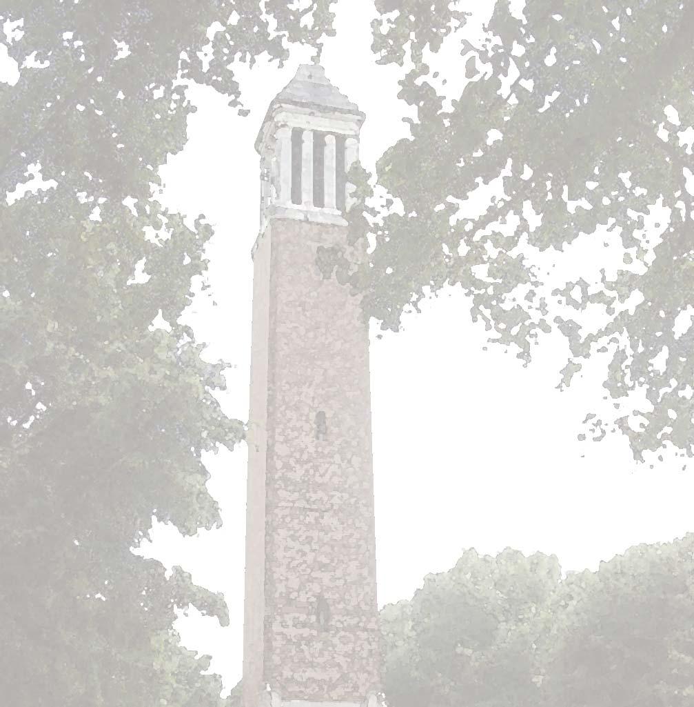
2 1 Introduction The University of Alabama Campus Master Plan was developed with a comprehensive open space, accessibility, and circulation system in mind, in order to promote the academic core of the campus as a pedestrian-oriented environment. To achieve this, all circulation systems and other modes of travel are planned and designed to serve and enhance the pedestrian experience. To minimize conflict between pedestrians and vehicles, the academic core of the campus is to be kept as vehicle-free as possible. New sidewalks and other walkways will be planned, designed and constructed to provide clearly defined routes that signal changes in use from solely pedestrian to a mix of pedestrians, bicycles and transit vehicles. Campus walkways and their immediate environs contribute to the character of the University as a hospitable, inspirational, and engaging traditional academic setting, steeped in the beauty and culture of the South. For example, one of the hallmark experiences of the University of Alabama campus is along the tree-lined walks surrounding the Quad, looking through the majestic oaks toward Denny Chimes and the Gorgas Library. Along the Quad, sidewalks are set back from the roadway, allowing ample space between vehicles and pedestrians. Large oaks provide shade, and decorative lamps provide evening light. Campus walkways provide comfortable, safe, and scenic paths of circulation, where students meet friends and classmates in passing, where informal gathering and conversation are happenstance, and where students, faculty and visitors participate in life outside of the classroom. Pedestrian System Plan 1

3 1.1 Implementing the Campus Master Plan The University is committed to the vision expressed in the Campus Master Plan. Implementation of this plan for campus sidewalks, paths and trails will help link critical functions of the University more closely together in a system that allows students, faculty, staff, and guests to safely and conveniently walk from one place to another. The University is also committed to enhancing its physical infrastructure to encourage pedestrian activity. By encouraging walking for general accessibility, the University supports active lifestyles for students, which is essential to their full intellectual and social growth. Following adoption of the Campus Master Plan, the campus rapidly converted from an automobile-dominated environment to one in which pedestrian accessibility and movement was granted primary importance. Removal of on-street parking and conversion of those spaces to bicycle and transit lanes and installation of a transit system occurred over a summer. Transition to a pedestrian-dominated environment placed great demand on the existing sidewalk system. Some walks are inadequately sized, while more need to be added in key locations. Others are in need of repair. Students cross streets in random locations, often impeding the flow of transit buses and other vehicles. Corner crossings are highly congested, especially 2 The University of Alabama


4 Introduction Students cross at mid-block, causing traffic to stall. Students need more standing room as they wait for crossing signals at highly congested corners. along University Boulevard. The time has come to upgrade and organize the campus Pedestrian System so that it meets the functional qualities and image that the University desires as a pedestrian-oriented campus. An improved pedestrian accessibility system will offer a denser network of routes across which pedestrian traffic may be more evenly distributed to ease congestion on heavily traveled routes. Certain walks will be widened, others repaired. Corner landings at intersections will be expanded to allow adequate space while waiting for crossing lights. Additional crosswalks also will be installed. Some campus sidewalks are undersized for increasing pedestrian volumes. Pedestrian System Plan 3


5 Right: This Campus Master Plan identified streets that would remain accessible to general vehicular traffic in the future. Below right: The Campus Master Plan expanded on the existing pedestrian network serving the campus. The Pedestrian System Plan provides guidance for design and construction of a unified pedestrian system that supports implementation of the Campus Master Plan in conformance with the University s mission. The Pedestrian System Plan includes photos and diagrams of various aspects of the pedestrian circulation system, plus design guidelines that supplement those in the overall Campus Design Guide. The plan will help guide phasing and prioritization of pedestrian system investment, inform specific plans for new construction, and provide consistency in the planning, design and construction, and routine maintenance of sidewalks and other pedestrian facilities. Campus bicycle network. On-street bicycle paths are shown in red. Shareduse paths are shown in blue. 4 The University of Alabama


6 Introduction 1.2 Complete Streets The campus pedestrian system is built on the premise that pedestrian ways are a critical component of a complete accessibility system. Consequently, pedestrian facilities along vehicular or transit streets should be designed and constructed as part of the total streetscape environment. A complete streetscape accommodates vehicular, transit, bicycle and pedestrian circulation. Complete streets also include landscaping, lighting, signage, transit stops, site furnishings, and other site elements. As an ensemble, a complete streetscape is visually compelling and environmentally comfortable for pedestrians. 1.3 Off-Street Paths Pedestrian paths located away from streets should also be planned and designed to include the immediate walking surface as well as the adjacent landscape and environmental surroundings. Regardless of setting, when planning, designing or building any part of the University of Alabama Pedestrian System, this plan and the following Design Guide must be considered carefully. Pedestrian System Plan 5

7 Designing the Pedestrian System The Pedestrian System is designed to support the University of Alabama as a pedestrian-oriented Campus. The plan identifies the campus elements, including major residential and academic buildings, parking structures, and major parking lots that generate the highest level of pedestrian traffic on a daily basis. These areas of highest use are linked with a primary walkway system that features sufficiently wide Primary Walks. Areas with less pedestrian traffic are linked by Secondary Walks; and the areas with the lowest levels of pedestrian traffic, are linked through Tertiary Walks. Shown in the diagrams at right is the layering of major pedestrian-generating facilities, Primary Walks, and Secondary Walks. Above Left: Major pedestrian traffic Generators Left: Generators and Primary Walks Below Left: Generators, Primary Walks, and Secondary Walks Academic and Residential Generators Parking Structure Parking Lot Primary Walks Secondary Walks 6 The University of Alabama


8 2 The Pedestrian System The University of Alabama Pedestrian System consists of several types of pedestrian facilities. Shown and described below, each calls for its own particular planning and design considerations. 1. Primary Walks carry the largest volume of traffic, and link the areas of highest use on the campus. A typical primary walk is approximately 12 feet wide, and can be as wide as 20 feet or even more. It is constructed of 6-inch thick reinforced concrete, with brick edging. 2. Secondary Walks generally serve medium traffic. The typical Secondary Walk is approximately 10 feet wide, and is constructed of 6-inch thick reinforced concrete, with brick edging. Primary Walk Detail A. For special effects in areas of primary interest, the primary walk can be modified by replacing the concrete panels with fields of brick herringbone pavers. A. B. Exact walkway widths should be determined on a case-by case basis. Specific conditions such as the width of adjacent walks, site constraints, and compatibility within the site context should inform the design of each segment of walkway. B. A primary walk that serves as a major concourse may need to be widened to as much as 20 feet. A simple variation of the primary walk allows for additional brick paving along each side to accommodate larger volumes of foot traffic. With this variation, the expanded edges may also allow for additional seating or other site furnishings. Secondary Walk Detail Pedestrian System Plan 7


9 The Pedestrian System Master Plan identifies the alignments of Primary, Secondary, and Tertiary Walks; intersections and crosswalks to be upgraded or installed, and frontages where improvements are needed to control pedestrian street crossings. Primary walks (red) and Secondary Walks (green) serve the major origins and destinations on campus. Tertiary walks support the major routes, connecting to individual buildings, between buildings, and to parking and service areas. 8 The University of Alabama


10 The Pedestrian System Tertiary Walks generally serve low traffic demand, provide important connections between buildings, open spaces, parking, and service areas. The typical tertiary walk is 6 feet wide minimum and constructed of 6-inch minimum thick concrete. See standard drawings. Shared-Use Paths are paved pathways that accommodate both bicycles and pedestrians. They serve as primary transportation corridors and provide an alternative to on-road facilities for less experienced cyclists. Often times, shared-use paths become favorite recreational trails. The shared-use path is at least 10 feet wide and may be constructed of concrete or asphalt. A. The shared-use path should have appropriate markings or signage to notify users that the facilities are shared between bicycles and pedestrians. The pathway may be marked with a solid or dashed centerline stripe or instead marked with a Shared-use Path Restriction (R9-7) Sign. It should be noted that when using the R9-7 sign, B. there is no pavement marking. The sign symbols may be switched as appropriate. When two-way shared use paths are located adjacent to a roadway, wide separation is desirable to demonstrate to pedestrians, bicyclists and motorists that the path is intended to function as an independent facility for bicyclists and others. When this is not possible, and the distance between the edge of the shoulder and the shared use path is less than 5 feet, a suitable physical barrier of minimum 42 inches in height, is recommended to prevent bicyclists from toppling into the roadway. Barriers also prevent path users from making unwanted movements between the path and the roadway and reinforce the concept that the path is an independent facility. Shared Use Path Detail Pedestrian System Plan 9


11 5. Walkways through Natural Settings are an appropriate response to the fact that the Campus Master Plan is organized around a central open space system that includes natural areas and drainage basins such as the Marr s Spring Preserve and the Crescent. These and other natural areas offer respite from the urban environment, with places for water recharge, wildlife habitat, and sustenance of natural ecological systems. A. B. Meandering paths should be placed carefully into campus natural areas to allow limited access while preserving natural beauty and drainage patterns. Paths should be constructed of porous paving materials, such as crushed limestone fines, mulch, or porous paving whenever possible. C. D. Paths through areas of regular flooding or inundation where washing or scouring may occur may be constructed of nonpermeable paving as appropriate. Drainage should be diverted naturally around sidewalks and trails using environmentally sensitive design solutions such as bio-swales, tree logs, or native stones. Footbridges should be considered in lieu of culverts and pipes. Wide swaths of mostly natural open spaces are to be maintained and enjoyed on campus. These are to the east and north edges of the campus around Marr s Spring and the Black Warrior River. 10 The University of Alabama
. 6.")


12 The Pedestrian System Existing crossings will be improved and new ones installed (orange). Some crossings will be raised as Pedestrian Tables to optimize pedestrian safety in key locations (purple). 6. Intersections and Crosswalks are another essential link in the pedestrian system. Existing intersections and crosswalks will be improved for safety and to provide adequate room for the queuing of pedestrians as they await crossing signals. Signals, special paving materials, raised pedestrian tables, and street markings improve safety by alerting motorists and by channeling pedestrians and bicyclists to safe crossing areas. Existing crosswalks in several locations will be retrofitted with ramps and other ADA accessibility features. Pedestrian Table Detail Crosswalk sign Pedestrian System Plan 11


13 Given the increasing rate of pedestrian traffic at several major intersections, corner landing areas, indicated at right in blue, will be expanded to provide more standing area. Colonial Drive University Blvd. Rose Administration Expanding standing space at the corner landings at the intersection of University Boulevard and Colonial Drive is a high priority for the University s pedestrian improvements program. Installation of post-and-chain bollards in several locations around the campus core, indicated at right in red, will deter pedestrians from crossing vehicular ways at unsafe points. 12 The University of Alabama

14 The Pedestrian System Implementation Priorities 1. Crosswalk and corner landing improvements, intersection-university Boulevard/Colonial Drive. 6. Installation of primary walk from parking south of Rose Administration to University Boulevard 2. Pedestrian table installation and corner landing improvements, intersection of McCorvey Drive/Campus Drive. 7. Closing of 7th Avenue and installation of primary and secondary walks, Woods Hall quad to Capstone Drive Installation of primary walk (west side) and secondary walk (east side), Colonial Drive. Extension of Crimson Promenade to Stadium Drive Pedestrian table installation and sidewalk upgrades on 6th Avenue Pedestrian table installation and sidewalk improvements on Colonial Drive 5. Crosswalk improvements and extension of secondary walks from Marrs Spring Road, along Stadium Drive, to the Crimson Promenade 10. Removal of parking and construction of pedestrian plaza, Capstone Drive from 6th Avenue to Colonial Drive Pedestrian System Plan 13

15 14 The University of Alabama

16 3 Design Guide This plan is an addendum to the University of Alabama Campus Master Plan, which sets overarching principles and recommendations for the ongoing physical development and improvement of the University. Likewise, this Design Guide supplements the Campus Design Guide in regard to the Campus Pedestrian System. The following are general guidelines for planning and design of walkways and their immediate surroundings. They should be supplemented by applicable guidelines from the Campus Design Guide. 3.1 General Guidelines Recognize and enhance natural features and character of the campus and area. Respond to the architectural and urban design framework of the area. Respond to the historical context of the surroundings. Provide environmental comforts that promote summer shading, summer breezes and other cooling effects. Provide areas for seating and informal gathering. Minimize earthwork, clearing, and tree removal. Divert stormwater runoff through environmentally sensitive practices. Minimize vehicular and bicycle conflicts with pedestrians. Meet ADA accessibility guidelines. Minimize slope or difficult terrain whenever possible. Provide clear visual zones to allow scanning for potential threats. Provide night lighting consistent with campus environmental safety and illumination standards. Provide safe access to emergency call boxes. Pedestrian System Plan 15

 Guidelines.")


17 3.2 Additional Guidelines 1. Paving Materials Sidewalk surfaces should be constructed of concrete and/or brick materials as appropriate to the context and sidewalk type. Concrete surfaces shall feature a light broom finish. 2. Crosswalks A. Primary Pedestrian Crossings. Where primary walks cross interior campus streets, crossings shall be raised, constructed as pedestrian tables. C. Ramps. All street crossings shall include handicap ramps at curbs in accordance with Americans with Disabilities Act (ADA) Guidelines. If project area includes curb ramps, the project shall include appropriate crossings and curb ramps on opposite corners to provide a complete, safe crossing. At curb ramps, brick pavers or other textured surfaces are used as detectable warnings for the visually impaired. B. University Boulevard. Crosswalks shall include skid-proof thermoplastic tape and shall meet applicable City and State requirements. 3. Shoulders Sidewalk edges shall include shoulders at least 2 feet wide, whenever possible, to allow additional room for passing. Maintain adequate separation between walks and retaining walls and steep slopes, or provide 42-inch height barriers. 4. Grades Sidewalk grades shall meet current ADA Guidelines regarding running slopes, cross-slopes, and other requirements for accessible routes. 16 The University of Alabama


18 Design Guide C. Handrails shall meet Universal Building Code height requirements and ADA requirements. When handrails are used along steps, rails shall fit integrally into the design of walls and columns, color black. 5. Fences, Rails and Barriers A. Ornamental Post-and-Chain Bollards may be used to control pedestrian movement in areas of open lawn, front lawns, or parks where a solid fence or ornamental rail would not be appropriate. A standard height post and chain type bollard shall be used. D. Ornamental Fencing. Shall be constructed of steel tube rail with 4 inch spacing between pickets, color black. 6. Drainage A. B. Drainage shall be diverted around or beneath walks. Curb Grates and Inlets shall be pedestrian- and bicycle-safe. Openings shall run perpendicular to the direction of bicycle traffic. B. Removable Bollards may be used in areas where vehicular access is limited. Bollards shall be lockable and easily removable, with sleeve coverings, rounded finial, color black. Pedestrian System Plan 17

19 18 The University of Alabama
20 4 Standard Specifications and Drawings Standard specifications and details for design and construction of sidewalks and supporting facilities are included in the University of Alabama Design and Construction Standards, including Section 4: Standard Drawings. These provide specific standards for construction of sidewalks and their immediate surroundings. They are to be coordinated with civil, lighting, and landscape design standards as appropriate. Primary Walk Expanded Primary Walk Secondary Walk Tertiary Walk Shared-Use Path Heavy-Duty Reinforced Concrete Walk Tooled Joints Sidewalk Radius Pedestrian Table Primary Crosswalk Standard Crosswalk Post and Chain Bollard Ornamental Fence Bench Pad Detail Bike Rack Pad Detail Trash Receptacle Pad Detail The Facilities Planning Department is responsible for developing and updating the University s Standard Specifications. Designers shall consult with the Department for information on standard specifications that may apply to each project. Pedestrian System Plan 19
21
22
23
24
25
26
27
28
29
30
31
32
33
34
35
36 ALL CONCRETE JOINTS SHALL BE TOOLED JOINTS. NO SAW-CUT JOINTS ALLOWED.
37 ALL CONCRETE JOINTS SHALL BE TOOLED JOINTS. NO SAW-CUT JOINTS ALLOWED.
38 ALL CONCRETE JOINTS SHALL BE TOOLED JOINTS. NO SAW-CUT JOINTS ALLOWED.
MAG Town of Cave Creek Bike Study Task 6 Executive Summary and Regional Significance Report
 Page 1 MAG Town of Cave Creek Bike Study Task 6 Executive Summary and Regional Significance Report August 1, 2012 MAG Project #481 Page 2 Task 6 Executive Summary and Regional Significance Report Introduction
Living Streets Policy
 Living Streets Policy Introduction Living streets balance the needs of motorists, bicyclists, pedestrians and transit riders in ways that promote safety and convenience, enhance community identity, create
Tonight is for you. Learn everything you can. Share all your ideas.
 Strathcona Neighbourhood Renewal Draft Concept Design Tonight is for you. Learn everything you can. Share all your ideas. What is Neighbourhood Renewal? Creating a design with you for your neighbourhood.
APPENDIX A: Complete Streets Checklist DRAFT NOVEMBER 2016
 APPENDIX A: Complete Streets Checklist DRAFT NOVEMBER 2016 Complete Streets Checklist MetroPlan Orlando s Complete Streets Checklist is an internal planning tool for staff to further implementation of
NJDOT Complete Streets Checklist
 Background The New Jersey Department of Transportation s Complete Streets Policy promotes a comprehensive, integrated, connected multi-modal network by providing connections to bicycling and walking trip
Off-road Trails. Guidance
 Off-road Trails Off-road trails are shared use paths located on an independent alignment that provide two-way travel for people walking, bicycling, and other non-motorized users. Trails specifically along
PUBLIC REALM MASTER PLAN
 WESTSHORE BUSINESS DISTRICT PUBLIC REALM MASTER PLAN MASTER PLAN COMMITTEE MEETING MARCH 20, 2013 WESTSHORE BUSINESS DISTRCT PUBLIC REALM MASTER PLAN MACRO-SCALE CONCEPT: A PUBLIC REALM FRAMEWORK DEFINED
Corpus Christi Metropolitan Transportation Plan Fiscal Year Introduction:
 Introduction: The Safe, Accountable, Flexible, Efficient Transportation Equity Act: A Legacy for Users (SAFETEA-LU) has continued the efforts started through the Intermodal Surface Transportation Efficiency
Cycle Track Design Best Practices Cycle Track Sections
 Design Best Practices Sections It is along street segments where the separation and protection methods of cycle tracks offer more comfort than conventional bicycle lanes, and are more attractive to a wide
Proposed. City of Grand Junction Complete Streets Policy. Exhibit 10
 Proposed City of Grand Junction Complete Streets Policy Exhibit 10 1 City of Grand Junction Complete Streets Policy Vision: The Complete Streets Vision is to develop a safe, efficient, and reliable travel
Appendix T CCMP TRAIL TRAFFIC & TRANSPORTATION DESIGN STANDARD
 Appendix T CCMP 3.3.4 TRAIL TRAFFIC & TRANSPORTATION DESIGN STANDARD 3.3.4 Trail Traffic and Transportation Design Multi-use trails have certain design standards, which vary depending on the agency that
INDOT Complete Streets Guideline & Policy
 INDOT Complete Streets Guideline & Policy INTRODUCTION The Complete Streets guidelines build upon multiple efforts and promote a multimodal transportation system that is integrated and sustains land use
Bicycle and Pedestrian Advisory Committee (BPAC) November 21, 2013
 November 21, 2013") Bicycle and Pedestrian Advisory Committee (BPAC) November 21, 2013 OVERALL LAND USE CONCEPT Overall Broadway Valdez District: 95.5 acres (35.1 acres right-of ways + 60.4 acres developable land) Plan Subareas:
Bicycle and Pedestrian Advisory Committee (BPAC) November 21, 2013 OVERALL LAND USE CONCEPT Overall Broadway Valdez District: 95.5 acres (35.1 acres right-of ways + 60.4 acres developable land) Plan Subareas:
Elm Street Business District: Streetscape and Signage Plan
 Winnetka Preliminary Streetscape & Signage Village Council Presentation 1 Elm Street Business District: Streetscape and Signage Plan VILLAGE OF WINNETKA DOWNTOWN MASTER PLAN VILLAGE COUNCIL PRESENTATION
Item to be Addressed Checklist Consideration YES NO N/A Required Description Complete Streets Guidelines
 Passaic County Complete Streets Checklist - Concept Development Project Name Item to be Addressed Checklist Consideration YES NO N/A Required Description Complete Streets Guidelines Existing Plans Have
TRANSPORTATION NEEDS ASSESSMENT
 TRANSPORTATION NEEDS ASSESSMENT A travel demand analysis was carried out to determine the operational issues and the potential benefit that adding traffic capacity would have on the road network. All the
WHEREAS delivery trucks also pass through the Narrows, into the northern parking lot, to loading docks in the back of the building.
 CEDAR-ISLES-DEAN NEIGHBORHOOD ASSOCIATION ( CIDNA ) RESOLUTION OPPOSING A DRUG STORE DRIVE THRU, AND COMMENDING DORAN COMPANIES FOR PROPOSING MITIGATING AMENITIES INCLUDING NEW LANDSCAPING AND A DEDICATED
RZC Appendix 8A Marymoor Subarea Street Requirements
 RZC Appendix 8A Marymoor Subarea Street Requirements For additional design details for Marymoor Subarea infrastructure, refer to the 2017 Marymoor Subarea Infrastructure Planning Report. STREET REQUIREMENTS
Safe Routes to School Action Plan Aberdeen, Idaho
 Background Aberdeen, Idaho is a largely agricultural community of nearly 2,000 people and is located in the southeast portion of the state on the western edge of American Falls Reservoir. The community
REGIONAL BICYCLE AND PEDESTRIAN DESIGN GUIDELINES
 REGIONAL BICYCLE AND PEDESTRIAN DESIGN GUIDELINES November 16, 2011 Deb Humphreys North Central Texas Council of Governments Bicycle and Pedestrian Advisory Committee Snapshot of the Guide 1. Introduction
ACTIVE TRANSPORTATION
 ACTIVE TRANSPORTATION Mobility 2040 Supported Goals Improve the availability of transportation options for people and goods. Support travel efficiency measures and system enhancements targeted at congestion
Appendix 3 Roadway and Bike/Ped Design Standards
 Appendix 3 Roadway and Bike/Ped Design Standards OTO Transportation Plan 2040 4/20/2017 Page A3-1 Adopted Standards The adopted OTO Design Standards and Major Thoroughfare Plan are contained herein.
Chapter 2: Standards for Access, Non-Motorized, and Transit
 Standards for Access, Non-Motorized, and Transit Chapter 2: Standards for Access, Non-Motorized, and Transit The Washtenaw County Access Management Plan was developed based on the analysis of existing
Streetscape: Core Shopping District
 Streetscape: Core Shopping District DRAFT DRAFT DRAFT May 00 Core Shopping District: Phase Blue Island s Core Shopping District is located along Western Avenue, between Grove and Union Streets. Streetscape
Observations and Ideas: Toomer s Corner Streetscape Improvements
 Observations and Ideas: Toomer s Corner Streetscape Improvements AUBURN DOWNTOWN MASTER PLAN planning downtown s future August 26, 2013 Observations: Vertical Clutter at Corners 6 3 7 5 9 2 8 4 1 Excess
Active Transportation Facility Glossary
 Active Transportation Facility Glossary This document defines different active transportation facilities and suggests appropriate corridor types. Click on a facility type to jump to its definition. Bike
CITY OF BLOOMINGTON COMPLETE STREETS POLICY
 CITY OF BLOOMINGTON COMPLETE STREETS POLICY POLICY OBJECTIVE: The City of Bloomington will enhance safety, mobility, accessibility and convenience for transportation network users of all ages and abilities,
MARTIN LUTHER KING JR. WAY
 OCTOBER 2011 40 Vision and Goals The Martin Luther King, Jr. Way Illustrative Master Plan that follows has been developed through a process of community involvement. It expresses a long term vision for
Complete Streets. Designing Streets for Everyone. Sarnia
 Complete Streets Designing Streets for Everyone Sarnia Complete Streets ~ Sarnia ~ 2018 Introduction Our City is made up of a network of streets that we use to go for a walk, cycle to work, drive to the
CITY OF COCOA BEACH 2025 COMPREHENSIVE PLAN. Section VIII Mobility Element Goals, Objectives, and Policies
 CITY OF COCOA BEACH 2025 COMPREHENSIVE PLAN Section VIII Mobility Element Goals, Objectives, and Policies Adopted August 6, 2015 by Ordinance No. 1591 VIII MOBILITY ELEMENT Table of Contents Page Number
PEDESTRIAN CIRCULATION & STREETSCAPE DESIGN
 CHAPTER 4 Chapter 4 Pedestrian Circulation & Trails PEDESTRIAN CIRCULATION & STREETSCAPE DESIGN In recent years, the City has constructed new sidewalks and enhanced existing ones in the downtown with brick
NM-POLICY 1: Improve service levels, participation, and options for non-motorized transportation modes throughout the County.
 Transportation PRINCE WILLIAM COUNTY 2008 COMPREHENSIVE PLAN NON-MOTORIZED PLAN CONTENTS Goals, Policies, and Action Strategies Table 4 (Bike Facility Classifications and Descriptions) Table 5 (Bike Facility
Exhibit 1 PLANNING COMMISSION AGENDA ITEM
 Exhibit 1 PLANNING COMMISSION AGENDA ITEM Project Name: Grand Junction Circulation Plan Grand Junction Complete Streets Policy Applicant: City of Grand Junction Representative: David Thornton Address:
TRAVEL PLAN: CENTRAL EUROPEAN UNIVERSITY CAMPUS REDEVELOPMENT PROJECT TRAVEL PLAN. Central European University Campus Redevelopment Project.
 TRAVEL PLAN Central European University Campus Redevelopment Project Page 1 Table of Contents Introduction... 3 Background... 7 Building Users... 7 Transportation in Community Consultation... 7 Summary
Morristown, NJ Complete Streets Policy
 Morristown, NJ Complete Streets Policy Introduction A Complete Street is defined as a means to provide safe access for all users by designing and operating a comprehensive, integrated, connected multi-modal
CHAPTER 16 PEDESTRIAN FACILITIES DESIGN AND TECHNICAL CRITERIA TABLE OF CONTENTS
 CHAPTER 16 PEDESTRIAN FACILITIES DESIGN AND TECHNICAL CRITERIA TABLE OF CONTENTS Section Title Page 16.1 General... 16-1 16.1.1 AASHTO Reference... 16-1 16.1.2 ADA Requirements... 16-1 16.2 Sidewalks...
Bicycle Facilities Planning
 Bicycle Facilities Planning Overview Types of Cyclists Purpose for Riding Types of Facilities Bike Lanes Bicycle Boulevards Cycle Tracks Intersections Signals Signing and Marking Discussion Types of Bicyclists
West Dimond Blvd Upgrade Jodhpur Street to Sand Lake Road
 West Dimond Blvd Jodhpur St to Sand Lake CSS Transportation Project Summary Municipality of Anchorage Project # 05 005 Project Manager: John Smith, P.E. (MOA PM&E) Project Administrator: Julie Makela,
DISTRIBUTION: Electronic Recipients List TRANSMITTAL LETTER NO. (17-01) MINNESOTA DEPARTMENT OF TRANSPORTATION. MANUAL: Road Design English Manual
 MINNESOTA DEPARTMENT OF TRANSPORTATION. MANUAL: Road Design English Manual") DISTRIBUTION: Electronic Recipients List MINNESOTA DEPARTMENT OF TRANSPORTATION DEVELOPED BY: Design Standards Unit ISSUED BY: Office of Project Management and Technical Support TRANSMITTAL LETTER NO.
DISTRIBUTION: Electronic Recipients List MINNESOTA DEPARTMENT OF TRANSPORTATION DEVELOPED BY: Design Standards Unit ISSUED BY: Office of Project Management and Technical Support TRANSMITTAL LETTER NO.
Non-Motorized Transportation 7-1
 Non-Motorized Transportation 7-1 Transportation facilities no longer mean just accommodating a vehicle powered by a combustion engine. Pedestrian and non-motorized facilities are important modes of travel
TRANSPORTATION STANDARDS
 INTRODUCTION LOCAL STREETS ON-STREET PARKING SIDEWALKS STREET LIGHTING STREET FURNISHINGS TRAFFIC CALMING STREET TREES MEDIAN PLANTING BOULEVARD LOCATIONS VILLAGE CENTER STREET LOCATIONS RESIDENTIAL STREET
S T A T I O N A R E A P L A N
 The Circulation and Access Plan describes vehicle, pedestrian, and transit improvements recommended within the Concept Plan. In order to create and sustain a vibrant business district that provides pedestrian-friendly
Agenda. Overview PRINCE GEORGE S PLAZA METRO AREA PEDESTRIAN PLAN
 PRINCE GEORGE S PLAZA METRO AREA PEDESTRIAN PLAN May 28, 2008 Agenda Welcome and introductions Project overview and issue identification Planning context and strengths Design challenges and initial recommendations
CONNECTIVITY PLAN. Adopted December 5, 2017 City of Virginia Beach
 CONNECTIVITY PLAN Adopted December 5, 2017 City of Virginia Beach CONTENTS 1.0 Background & Purpose... 2 2.0 Existing Inventory & Analysis... 3 ViBe District Existing Walking Conditions... 4 3.0 ViBe District
CURBSIDE ACTIVITY DESIGN
 5 CURBSIDE ACTIVITY DESIGN This chapter provides design guidance for separated bike lanes adjacent to curbside activities including parking, loading and bus stops. Typical configurations are presented
15 April CAMPUS MASTER PLAN UPATE F o c us G r o up M o b ility
 15 April 2016 CAMPUS MASTER PLAN UPATE F o c us G r o up M o b ility AGENDA What We Heard Campus Framework & Open Space Network Mobility Approach Supporting the Pedestrian Environment Mobility & Sustainability
Omaha s Complete Streets Policy
 Omaha s Complete Streets Policy (Adopted August 2015) VISION To create great places and enhance our quality of life, the City of Omaha will provide safe, accessible streets for all users. Complete Streets
Recommended Roadway Plan Section 2 - Land Development and Roadway Access
 Recommended Roadway Plan Section 2 - Land Development and Roadway Access SECTION 2 Land Development and Roadway Access 2.1 Land Use and Access Management The Federal Highway Administration (FHWA) defines
o n - m o t o r i z e d transportation is an overlooked element that can greatly enhance the overall quality of life for the community s residents.
 N o n - m o t o r i z e d transportation is an overlooked element that can greatly enhance the overall quality of life for the community s residents. 84 Transportation CHAPTER 11 INTRODUCTION Transportation
Arlington s Master Transportation Plan
 Arlington s Master Transportation Plan The Master Transportation Plan (MTP) Adopted in eight parts Goals & Policies element and MTP Map adopted in 2007 Bicycle, Pedestrian and Demand and Systems Management
Bikeway action plan. Bicycle Friendly Community Workshop March 5, 2007 Rochester, MN
 Bikeway action plan Summary The was held on March 5, 2007 at the Rochester Mayo Civic Center. The workshop was hosted by Rochester-Olmsted County Planning Department in collaboration with the League of
Multimodal Through Corridors and Placemaking Corridors
 68 Multimodal Through Corridors and Placemaking Corridors Corridors have different functions in a region. Some corridors are used to get smoothly and rapidly through a region or to get quickly to major
FOCUS AREA 1 - Alberta Avenue Pocket Park 3 (121 Ave and 92 St)
") FOCUS AREA 1 - Alberta Avenue Pocket Park 3 (121 Ave and 92 St) New benches Plant evergreen trees Widen existing sidewalk from 1.5m to 1.8m Marked crosswalk 1.8m wide sidewalk Add pedestrian oriented lights
FOCUS AREA 1 - Alberta Avenue Pocket Park 3 (121 Ave and 92 St) New benches Plant evergreen trees Widen existing sidewalk from 1.5m to 1.8m Marked crosswalk 1.8m wide sidewalk Add pedestrian oriented lights
Building Great Neighbourhoods BELLEVUE AND VIRGINIA PARK
 Building Great Neighbourhoods BELLEVUE AND VIRGINIA PARK This is Meeting 2 Unfortunately, some residents in Bellevue and Virginia Park received the wrong information for this public open house (Meeting
Watertown Complete Streets Prioritization Plan. Public Meeting #1 December 14, 2017
 Watertown Complete Streets Prioritization Plan Public Meeting #1 December 14, 2017 Goals for Public Meeting Overview of MassDOT Complete Streets Funding Program Educate the community on Complete Streets
Broad Street Bicycle Boulevard Design Guidelines
 Broad Street Bicycle Boulevard Design Guidelines Building from the strategies introduced in the 2013 Bicycle Transportation Plan and community input received thus far, City Transportation Staff have identified
ARLINGTON COUNTY, VIRGINIA
 ARLINGTON COUNTY, VIRGINIA County Board Agenda Item Meeting of October 15, 2016 DATE: October 7, 2016 SUBJECT: Adoption of amendments to the Master Transportation Plan (MTP) to create a new Pedestrian
On Road Bikeways Part 1: Bicycle Lane Design
 On Road Bikeways Part 1: Bicycle Lane Design Presentation by: Nick Jackson Bill Schultheiss, P.E. September 04, 2012 FOLLOW THE CONVERSATION ON TWITTER Toole Design Group is live tweeting this webinar
Perryville TOD and Greenway Plan
 Perryville TOD and Greenway Plan Greenway Glossary Pathway: A bicycle and pedestrian path separated from motorized vehicular traffic by an open space, barrier or curb. Multi-use paths may be within the
Chapter 3 DESIGN SPECIFICATIONS
 Brampton PathWays Planning and Design Guidelines 27 Chapter 3 DESIGN SPECIFICATIONS 3.1 CLASS 1 MULTI-USE PATH Off-road multi-use trails are the backbone of the Brampton PathWays Network. They are typically
Ballston Station Multimodal Study WMATA and Arlington County. Meeting Minutes
 Date of Meeting: June 10, 2010 Location: Ballston Metrorail Station and NRECA Building 4301 Wilson Blvd, Arlington, VA Subject: Ballston Station Multimodal Study Stakeholder Meeting #1 Summary: This first
CONNECTING PEOPLE TO PLACES
 CONNECTING PEOPLE TO PLACES 82 EAST BENCH MASTER PLAN 07 Introduction The East Bench transportation system is a collection of slow moving, treelined residential streets and major arteries that are the
14 TH STREET TRANSPORTATION & STREETSCAPE DESIGN STUDY PLAN B PLAN B TRANSPORTATION & STREETSCAPE RECOMMENDATIONS
 14 TH STREET TRANSPORTATION & STREETSCAPE DESIGN STUDY PLAN B PLAN B TRANSPORTATION & STREETSCAPE RECOMMENDATIONS 141 Symbols Recommendations - Southern End of 14th Street Study Area Streetscape Each icon
PROCEDURE FOR ACCOMMODATING PEDESTRIANS IN WORK ZONES FOR CONSTRUCTION AND MAINTENANCE
 PROCEDURE FOR ACCOMMODATING PEDESTRIANS IN WORK ZONES FOR CONSTRUCTION AND MAINTENANCE A.1 STANDARD Measures shall be taken to accommodate pedestrian traffic through and/or around Work Zones for Construction
STREETSCAPE CONCEPT PLAN
 03 STREETSCAPE CONCEPT PLAN Zone 1 This zone includes the gateway into both the downtown and the Village at Harlem. The gateway features are shown closer to the Harlem intersection to make them more prominent.
Transportation Planning Division
 Transportation Planning Division Presentation Outline Study Tasks Recap of Previous Meetings Data Collected Focus Areas within Study Limits Design Principles Tool Box Recommended Concepts Schedule Moving
Bicycle and Pedestrian Chapter TPP Update Overview. TAB September 20, 2017
 Bicycle and Pedestrian Chapter TPP Update Overview TAB September 20, 2017 Bicycling & Walking in the Twin Cities Where are we now? The Bike-Pedestrian system Current trends New developments Where are we
SR-203 Sidewalks and Town-Wide Mobility Improvements. Town Council Presentation September 7, 2016
 SR-203 Sidewalks and Town-Wide Mobility Improvements Town Council Presentation September 7, 2016 SR-203 Sidewalks and Town- Wide Mobility Improvements SR-203 Sidewalks and Appurtenances Town-Wide Mobility
Chapter 4 TOOLBOX AND SAMPLE BIKE BOULEVARD LAYOUT
 Chapter 4 TOOLBOX AND SAMPLE BIKE BOULEVARD LAYOUT OVERVIEW This chapter describes a cohesive set of strategies to create a bicycle boulevard, namely to make streets safer and more efficient for bicycle
Fitting Light Rail through Well-established Communities
 Fitting Light Rail through Well-established Communities San Francisco 2008 Michael D. Madden Chief, Project Development, Maryland Transit Administration Project Setting Located inside the Capital Beltway
Hennepin County Bicycle and Pedestrian Planning
 Hennepin County Bicycle and Pedestrian Planning 1 Value of bicycle and sidewalk systems Safety Livability Mobility Health Personal Finances Economic Sustainability Clean Air Recreation Parking and congestion
Figure 4-10: Pedestrian Improvements Types of Potential Station Area Improvements - Place-Making Improvements
 INCORPORATE FEATURE PAVIN IN CROSSWALK AND INTERSECTION FIELDS Identifies high-priority pedestrian areas and create a station identity through colorful and interesting patterns ADD CURB EXTENSIONS Extending
Site Improvements
 Sections Included In This Standard: 1.1 Bicycle Facilities 1.2 Guardrails 1.3 Parking Bumpers 1.4 Traffic Signage 1.5 Traffic Signals 1.6 Traffic Impact Studies 1.7 Vision Triangle 1.8 Bus Stop Shelters
PRINCE GEORGE S PLAZA METRO AREA PEDESTRIAN PLAN
 PRINCE GEORGE S PLAZA METRO AREA PEDESTRIAN PLAN May 28, 2008 Agenda Welcome and introductions Project overview and issue identification Planning context and strengths Design challenges and initial recommendations
New Measure A Expenditure Categories DEFINITIONS OF ELIGIBLE EXPENDITURES Adopted March 8, 2007
 New Measure A Expenditure Categories DEFINITIONS OF ELIGIBLE EXPENDITURES Adopted March 8, 2007 City Street and County Road Maintenance Program The preservation and keeping of public street and road rights-of-way
A CHANGING CITY. of Edmonton, it is essential that it reflects the long-term vision of the City.
 A CHANGING CITY By the year 2040, Edmonton will be home to more than 1 million people. To accommodate growth and support a healthy and compact city, we need a new approach to development/redevelopment
Michael Parmer, Management Aide, City Manager's Office
 P139 STAFF REPORT f CITY NL- NAGER' S OFFICE RANCHO Date: C;UCAMONGA To: From: Subject: Mayor and Members of the City Council John R. Gillison, City Manager Michael Parmer, Management Aide, City Manager's
East Burke Transportation, Safety and Capacity Improvements
 East Burke Transportation, Safety and Capacity Improvements The purpose of this project is to increase mobility and improve safety for pedestrians, cyclists, and motor vehicles along VT Route 114 in the
Steps to Conducting a Complete Streets Assessment
 Steps to Conducting a Complete Streets Assessment Familiarize yourself with Complete Streets Read through the Complete Streets Assessment Guidelines. This will give you an idea of what Complete Streets
Welcome! Public Open House on UBC s Transportation Plan
 1 Welcome! Public Open House on UBC s Transportation Plan Public open house hours: to When it comes to on-campus transportation, what do you think is working well and what are some opportunities for improvement?
5. Automobile Circulation, Wayfinding and Signage
 5. Automobile Circulation, Wayfinding and Signage Policy: The City Center should have a balanced, safe, and interconnected circulation system that provides expanded travel opportunities for transit, pedestrian,
TOWN OF PORTLAND, CONNECTICUT COMPLETE STREETS POLICY
 TOWN OF PORTLAND, CONNECTICUT COMPLETE STREETS POLICY I. VISION, GOALS & PRINCIPLES VISION To improve the streets of Portland making them safer and more accessible for all users including pedestrians,
Roads and Vehicular Traffic Design Principles. Roads and Vehicular Traffic Recommendations
 CIRCULATION AND PARKING roads and vehicular traffic The Campus Master Plan updates the campus transportation network through a multi-modal approach that encourages walking and biking while improving vehicular
ACTIVE TRANSPORTATION/NONMOTORIZED TRANSPORTATION
 ACTIVE TRANSPORTATION/NONMOTORIZED TRANSPORTATION BACKGROUND Active transportation, also known as nonmotorized transportation, is increasingly recognized as an important consideration when planning and
Brooklyn Boulevard (County Road 152) Reconstruction Project Phase I. OPEN HOUSE June 20, 2017
 Reconstruction Project Phase I. OPEN HOUSE June 20, 2017") Brooklyn Boulevard (County Road 152) Reconstruction Project Phase I OPEN HOUSE June 20, 2017 Brooklyn Boulevard (County Road 152) Phase I Project Partners Project Lead Other Project Partners include Brooklyn
Brooklyn Boulevard (County Road 152) Reconstruction Project Phase I OPEN HOUSE June 20, 2017 Brooklyn Boulevard (County Road 152) Phase I Project Partners Project Lead Other Project Partners include Brooklyn
Solana Beach Comprehensive Active Transportation Strategy (CATS)
") Solana Beach Comprehensive Active Transportation Strategy (CATS) 3.0 Goals & Policies The Solana Beach CATS goals and objectives outlined below were largely drawn from the Solana Beach Circulation Element
Solana Beach Comprehensive Active Transportation Strategy (CATS) 3.0 Goals & Policies The Solana Beach CATS goals and objectives outlined below were largely drawn from the Solana Beach Circulation Element
Ocean Park Boulevard Green Street Project Alternatives & Trade Offs
 Planning Commission March 4, 2009 Ocean Park Boulevard Green Street Project Alternatives & Trade Offs Purpose of Tonight s Meeting Review concept plans and options Provide input on alternatives and trade-offs
2.0 Existing Conditions
 20 2.0 Existing Conditions 2.1 Land Use, Future Growth Patterns, Physical Barriers Geographic Overview Sutter County s land use pattern is characterized by extensive agricultural areas, significant natural
Anne Arundel County BICYCLE, PEDESTRIAN, TRANSIT ASSESSMENT GUIDELINES
 Anne Arundel County BICYCLE, PEDESTRIAN, TRANSIT ASSESSMENT GUIDELINES December 2018 TABLE OF CONTENTS I. Executive Summary 3 II. When Is A Bicycle Pedestrian Transit Assessment (BPTA) Required? 4 III.
DEFINING THE STREETSCAPE DRAFT
 3 DEFINING THE STREETSCAPE Context Sensitive Design Context Sensitive Design The structuring elements of streetscapes for the City of Vaughan are road classifi cation, streetscape type and level of service.
University of Victoria Campus Cycling Plan Terms of Reference. 1.0 Project Description
 University of Victoria Campus Cycling Plan Terms of Reference 1.0 Project Description The Campus Cycling Plan, a first for the University, will provide a comprehensive and coordinated approach to support
Shared Use Path Design
 12B-2 Design Manual Chapter 12 - Sidewalks and Bicycle Facilities 12B - Bicycle Facilities Shared Use Path Design A. Accessible Shared Use Path Design 1. General: Applicable portions from the following
Aurora Urban Street Standards For Transit Oriented Developments and Urban Centers
 Aurora Urban Street Standards For Transit Oriented Developments and Urban Centers I. Purpose These standards will be applied to create a safe, comfortable, pleasant and pedestrian-friendly multi-modal
MASTER BICYCLE AND PEDESTRIAN PLAN
 VILLAGE OF NORTHBROOK MASTER BICYCLE AND PEDESTRIAN PLAN DRAFT PLAN OPEN HOUSE May 2, 2018 AGENDA 1. Community Engagement 2. Vision and Goals 3. General Structure of Plan 4. Recommendations Overview 5.
CITY OF ELKO BICYCLE AND PATHWAY PLAN
 CITY OF ELKO BICYCLE AND PATHWAY PLAN INTRODUCTION: The City of Elko is intended to provide the basic framework for the development of a functional bicycle and pathway system for the community with connections
Bases, Ballasts, and Paving
 Sections Included In This Standard: 1.1 Paving and Surfacing 1.2 Protection of the Work 1.3 Repair of Pavement 1.4 Pavement Marking 1.1 PAVING AND SURFACING A. DESIGN REQUIREMENTS 1. Applicable Design
Complete Streets Policy DAVID CRONIN, P.E., CITY ENGINEER
 Complete Streets Policy DAVID CRONIN, P.E., CITY ENGINEER Complete Streets City Commission adopted a Complete Streets policy in 2012 Complete Streets are road networks that are designed for all users:
Chapter 5 Future Transportation
 Chapter 5 Future Transportation The Future Land Use Plan identifies the desired land use designations. The land uses desired for Crozet depend, in large part, on the success of the transportation system,
5. RUNNINGWAY GUIDELINES
 5. RUNNINGWAY GUIDELINES These guidelines should be considered collectively when making runningway decisions. A runningway is the linear component of the transit system that forms the right-of-way reserved
Traffic Improvements for the Transit Oriented Development District (TODD) Meriden Public Library March 11, 2014
 Meriden Public Library March 11, 2014") Traffic Improvements for the Transit Oriented Development District (TODD) Meriden Public Library March 11, 2014 Project Overview Coordinate roadway improvements with other major projects HUB Flood Control
Traffic Improvements for the Transit Oriented Development District (TODD) Meriden Public Library March 11, 2014 Project Overview Coordinate roadway improvements with other major projects HUB Flood Control