REQUIREMENTS FOR TRAFFIC CONTROL PLAN SUBMISSION
|
|
|
- Letitia Welch
- 5 years ago
- Views:
Transcription
1 REQUIREMENTS FOR TRAFFIC CONTROL PLAN SUBMISSION A draft traffic control plan, consistent with the following applicable conditions, must be included in every permit application submitted to the City of Palo Alto Public Works Department for projects that involve work within the City right-of-way. The traffic control plan must approved prior to the start of work within the City right-of-way. The Public Works Department and the Planning and Community Environment Department - Transportation Division may require additional measures of traffic control or time-of-work restrictions on a case-by-case basis. Below are some guidelines for producing this required plan: General Traffic Control Plan Submission Requirements: The Applicant shall submit traffic control plans to the Public Works Department for approval at the time of the submission of the permit application. The Public Works Department may require approval from other departments depending on the location, duration, and type of work to be conducted. Additional requirements include, but may not be limited to the following: 1. Submitted traffic control plans shall include a schedule of construction showing each phase of the Project and the anticipated method of handling traffic for each phase. The plan shall include a to-scale drawing of the street, lane configuration (including all bicycle lanes), onstreet parking, and sidewalks relative to the Project area extended the furthest temporary traffic control device. The location of signs, barricades, cones, etc., to warn, direct, and guide the traffic shall be shown on the plan. The work shall not restrict visibility of any existing traffic control devices, including traffic signals, signs, etc. Otherwise, temporary installation of supplemental traffic control devices will be required. 2. The Applicant shall refer to the California Manual on Uniform Traffic Control Devices (CA- MUTCD) and/or the Work Area Traffic Control Handbook (WATCH) for traffic control planning. The plan shall meet the requirements for the speed limit of the street(s) affected, or post temporary, reduced construction zone speed limits. 3. An electronic arrow board warning device may be required for shifting of traffic to the wrong side of the road, merging of lanes on arterial roadways, and as otherwise required in the approved traffic control plan. 4. All signs at the Project site shall conform to the most recent Caltrans standards and be of the international symbol design whenever available. 5. The Applicant will be required to pay for any public off-street time-limited parking spaces, within the University Avenue and California Avenue business districts or Stanford University areas that will be rendered unusable to the public as a result of the Project. These permits are available from the Public Works Department. This includes spaces to maintain traffic lanes, for parking of construction vehicles during the work hours, or for issuing parking permits to the parked vehicles displaced from their private parking spaces, etc. The proposed use of parking spaces must be included in the draft traffic control plan. 6. The Applicant shall maintain one lane of traffic in each direction at all times on all streets. The clear width of the lane shall be a minimum of 10 feet per lane, or 12 feet, if only one lane is provided. Any required flagging operations shall conform to Caltrans standards for dress, equipment and execution of this operation. Rev 6/30/16
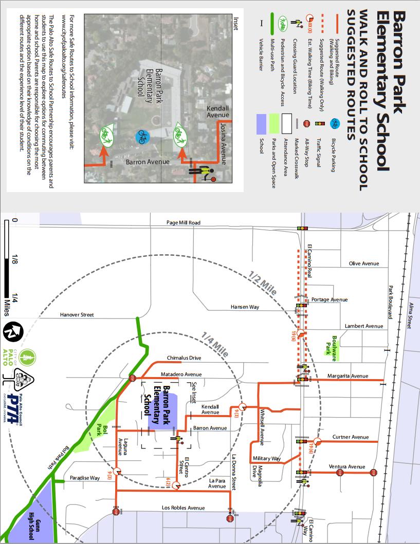
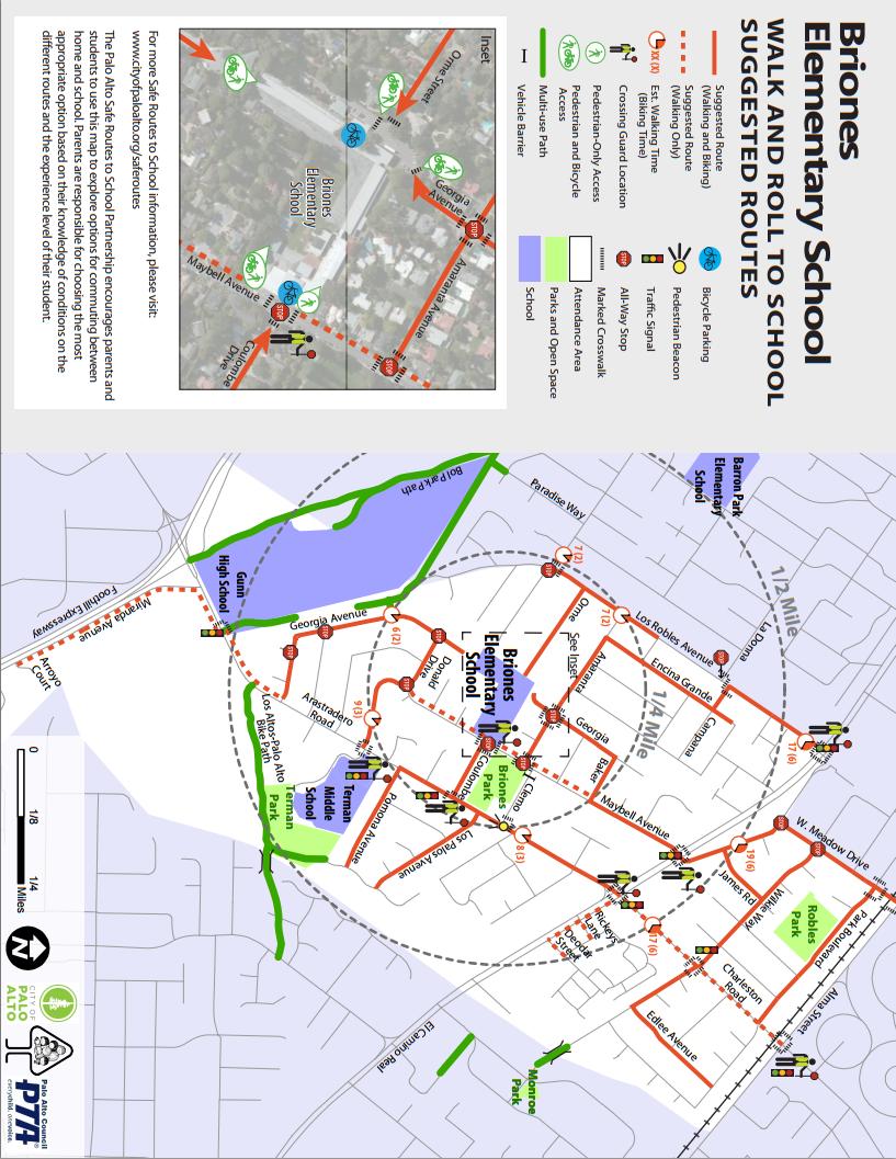
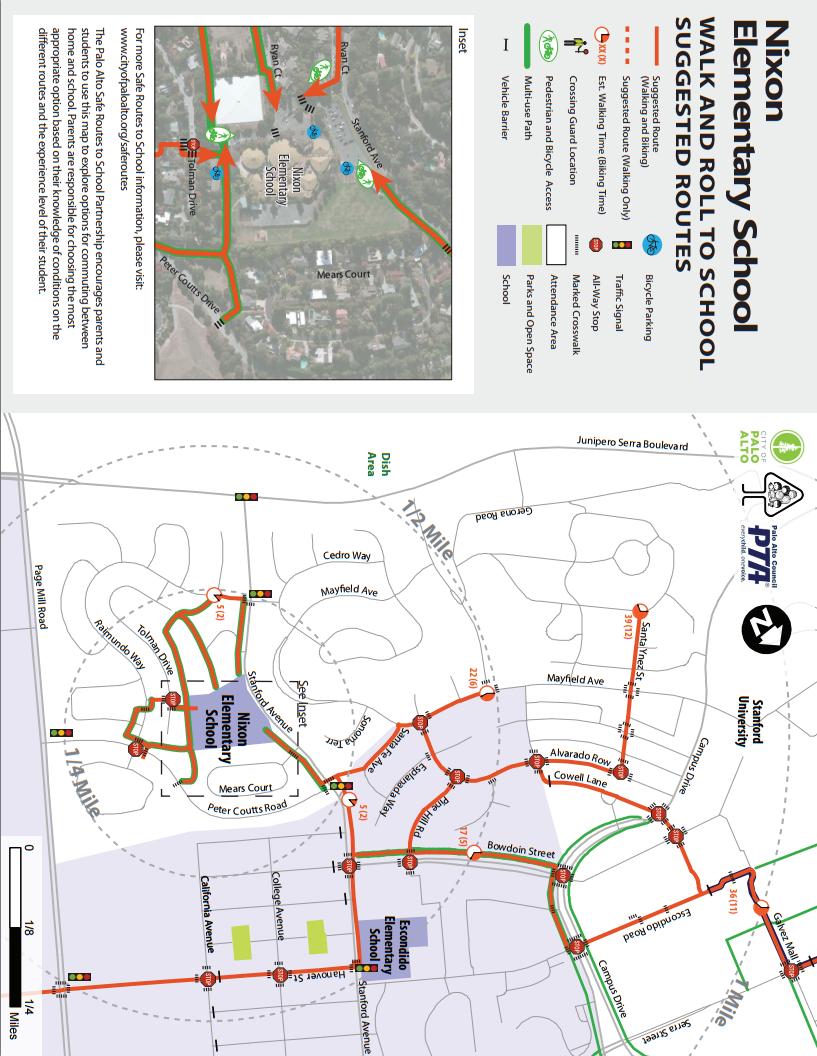
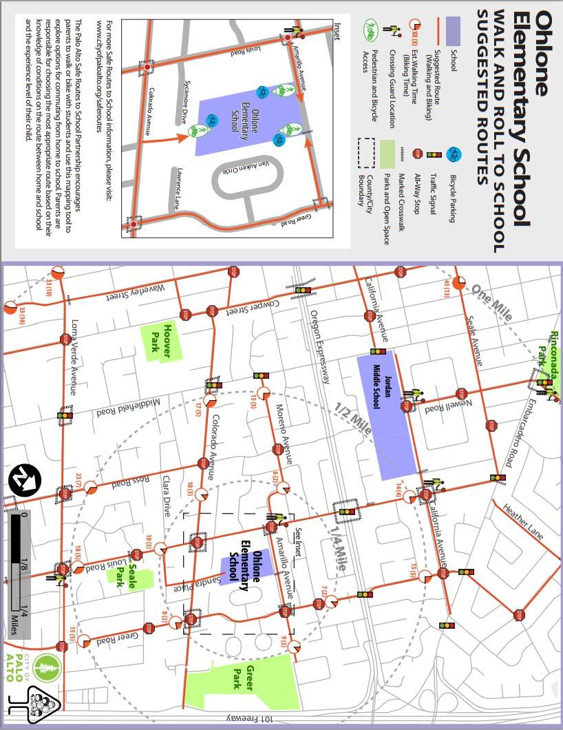
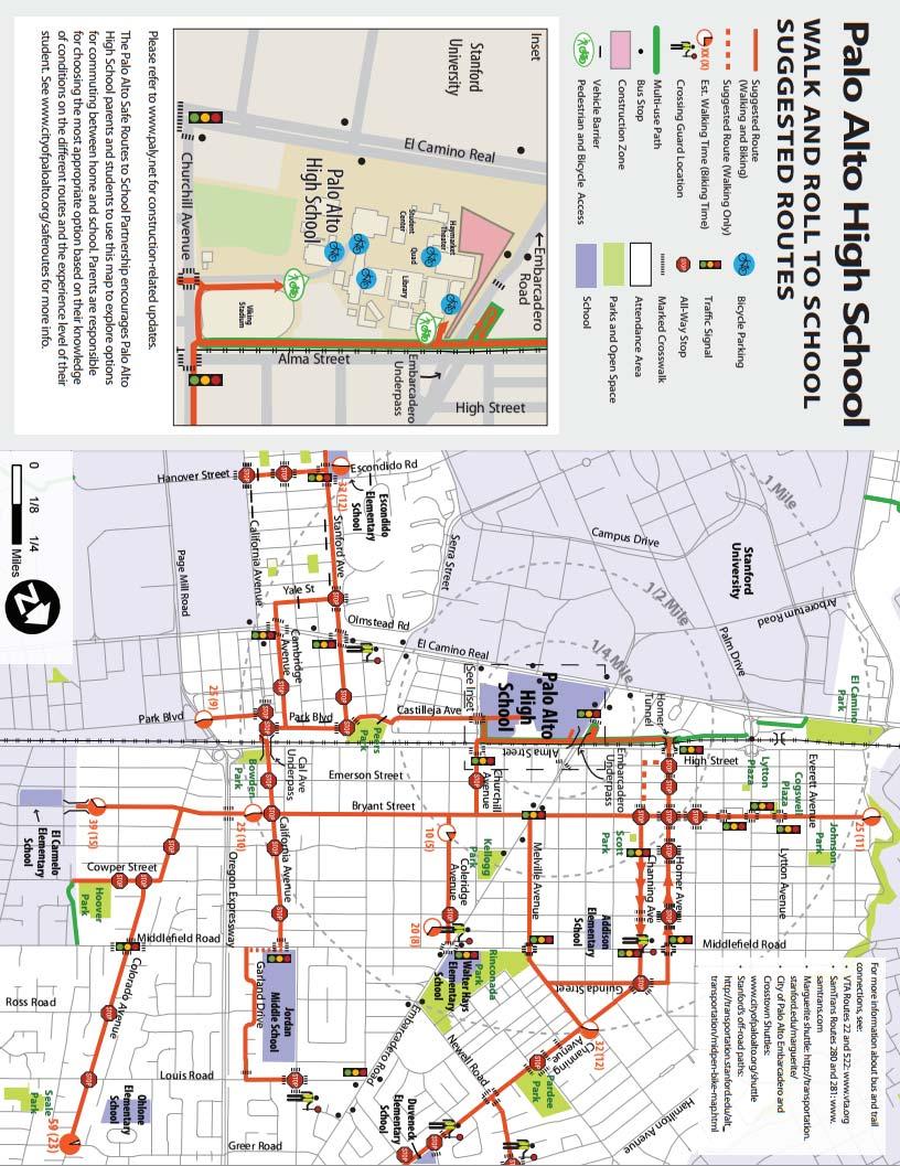
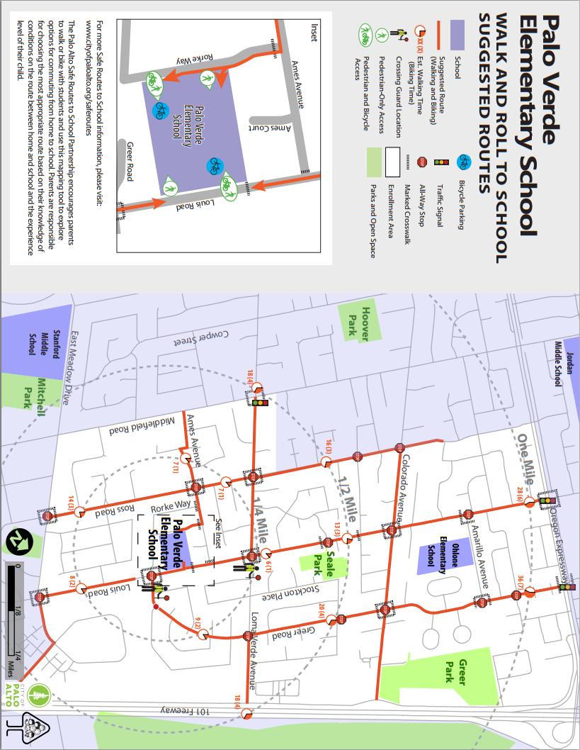
2 7. If the Project site does not conform to the approved traffic control plan at all times, the Police Department may take over the traffic control at the expense of the Applicant. The Public Works Department and the Planning and Community Environment Department - Transportation Division have the authority to issue a stop-work order if the Project site violates minimum traffic safety standards. Temporary Detours (Vehicle, Bicycle, and Pedestrian) In general, the Applicant shall maintain all motor vehicle, pedestrian, and bicycle movements. Total closures of arterials, collector streets, business district streets, driveways, or alleys will normally not be permitted. Closures of designated bicycle boulevards and school routes, as shown on adopted Walk and Roll Maps, will only be permitted on a case-by-case basis. Closure of local streets may be permitted; however, the Applicant shall always maintain access to abutting parcels and access for emergency vehicles. 8. A minimum four-foot-wide (4-foot-wide) clear sidewalk shall be maintained at all times, unless the Project makes closure unavoidable, in which case the sidewalk may be closed only while working, subject to permit approval. An alternate pedestrian route may be required for the duration of the closure. These alternate pedestrian routes shall conform to the requirements of the California Building Code (CBC) and the U.S. Access Board Guidelines for Public Rights-of-way. At intersections, work will be permitted on only one corner at a time in order to maintain safe pedestrian movements through the intersection. Each crosswalk and sidewalk, when interrupted by excavation, shall be provided with a safe pedestrian crossing platform with handrails. Any damaged pavement markings shall be temporarily restored prior to returning the area to the public use. Permanent restoration must be accomplished within seven (7) days of project completion. 9. Any Project that requires detouring bicycle traffic from bicycle boulevards and school routes, as shown on adopted Walk and Roll Maps, shall provide a continuously-signed bicycle detour route that does not require bicyclists to travel along a sidewalk, arterial, expressway, or highway (i.e. El Camino Real). Temporary two-way bicycle paths must be a minimum of eight (8) feet wide and approved by the Planning and Community Environment Department Transportation Division. Temporary one-way bicycle paths must be a minimum of six (6) feet wide and approved by the Planning and Community Environment Department Transportation Division. 10. If Project will impact transit stops or transit routes, the traffic control plan should indicate what actions will be taken to mitigate impacts on transit services such as providing alternative/temporary transit stop locations, temporary wayfinding signage, and alternative route locations suitable for oversized buses. General Time Restrictions for Construction Activities General work hours allowed are Monday through Friday, 8:00 AM to 6:00 PM, and Saturday 9:00 AM to 6:00 PM. Area specific time restrictions for temporary traffic control are considered on a case by case basis; however the following restrictions are typically followed: 11. Work on arterial and collector streets will not be permitted between the hours of 7:00 and 9:00 AM and 4:00 and 6:00 PM. The streets include: Alma St, Arastradero Rd, Arboretum Dr, California Ave, Channing Ave, Colorado Ave, E Bayshore Rd, E Charleston Rd, E Meadow Cir, E Meadow Dr, Embarcadero Rd, Fabian Wy, Louis Rd, Middlefield Rd, Palo Alto Ave Rev 6/30/16
3 (west of Alma St), San Antonio Rd, Sand Hill Rd, University Ave, Hansen Wy, Hillview Dr, Park Blvd, Stanford Ave, Quarry Rd, W Charleston Rd, Bayshore Rd W Meadow Dr, and Welch Rd. Any exceptions to these must be approved by both the Public Works Department and Planning and Community Environment Department Transportation Division. 12. Projects affecting motor vehicle, pedestrian or bicycle traffic in business districts is generally only permitted between the hours of 9:00 AM and 4:00 PM. Business Districts are generally considered to be the following areas: University Ave District (Downtown): bounded by Alma St, Webster Ave, Lytton Ave, Forest Ave California Ave District: bounded by El Camino Real, Caltrain corridor, Sherman Ave and Cambridge Ave 13. No work will be permitted within 1500 feet of school grounds or along school routes, as shown on adopted Walk and Roll Maps, until after 8:45 AM on school days (see current PAUSD School Year Calendar). Other special restrictions may be required at heavily used school crossings or on school routes beyond the 1500-foot distance, as deemed necessary for student safety. Public Notification The Applicant shall notify the abutting property owners and tenants at least 72 hours before commencing work on the project. If the driveway to any garage or parking area will need to be closed for permitted construction work, the affected property owner or tenant shall be served notice in writing regarding this necessary closure. Arrangements shall be made with this owner or tenant to provide mitigation measures that are acceptable to them. Evidence of these negotiated mitigation measures must be submitted with the draft traffic control plan. Additional notification may be required by the Public Works Department, depending on the location and scale of the project. 14. The Permittee is responsible for posting "No Parking-Tow Away" signs if temporarily restricted parking is necessary. A minimum of 72 hours advance notification is required for this posting. A sign must be placed at each affected parking space. A minimum of one inch printed letters shall be used on the sign and provide the following information: (1) complete date(s) and hours of parking closure, and (2) telephone number of Police Department for inquiry of towed vehicles. The Police Department must be notified at the time of posting. 15. If the Project will impact school routes, as shown on adopted Walk and Roll Maps, the Applicant will be required to contact school administrators and PTA officers to address student access prior to submittal and approval of the draft traffic control plan. 16. If the project will impact transit stops or transit routes, the Applicant will be required to contact AC Transit, Santa Clara Valley Transportation Authority, SamTrans, Stanford University Parking and Transportation Services, the Planning and Community Environment Department Transportation Division, and/or any other affected transit operators to address relocation of facilities or rerouting of buses prior to submittal and approval of the draft traffic control plan. The draft traffic control plan shall indicate what actions will be taken to mitigate impacts on transit services. 17. The Applicant may be required, at Applicant s cost, to hire Palo Alto police officers or a Certified Traffic Control Contractor to direct traffic when working at signalized intersections. A minimum of two police officers per intersection may be required. This requirement will Rev 6/30/16
4 primarily be enforced when: a) equipment is intermittently blocking or crossing a travel lane, b) only one travel lane is available for two-way traffic, c) multiple movements are temporarily required to share the same travel lane, d) working at multi-lane signalized intersections, and e) traffic signals are inoperable, unsafe conditions, or capacity is significantly reduced due to the project. 18. The above requirements are minimum, and do not limit the Applicant s responsibility and liability for doing all that is practical and necessary to ensure the safety of workers, pedestrians, bicyclists, and motorists. The Applicant shall conform to the required traffic control conditions which are generally applicable to most common situations. Based on the nature of a job, additional conditions or exceptions to the above conditions may be necessary. This publication is intended to be an informal means of informing the public about a City process. Although it is assumed that the information provided is accurate, the sheet is not intended to create any sort of legal obligation on the City s part. The actual process is governed by City code, regulations and procedures, and the reader should make specific inquiry to the City for specific cases. Rev 6/30/16
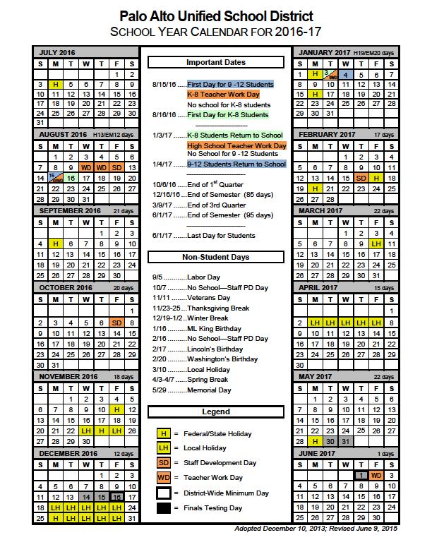
5 PAUSD BELL TIMES SCHOOL AM PM WEDS KINDER Elementary: Addison 8:15 2:55 1:15 12:00 Barron Park 8:15 2:45 1:30 11:50 J. Briones 8:15 2:40 1:30 11:50 Duveneck 8:05 2:35 1:05 11:45 El Carmelo 8:25 2:55 1:30 12:00 Escondido 8:10 2:45 1:30` 12:00 Fairmeadow 8:30 3:00 1:40 12:05 W. Hayes 8:25 2:55 1:30 12:00 Hoover 8:00 2:30 1:30 12:00 Nixon 8:00 2:30 1:20 11:40 Ohlone 8:15 2:45 1:30 11:55 Palo Verde 8:15 2:50 1:25 11:45 Greendell PS 8:45 11:45 Middle: Jordan 8:10 3:05 1:40 JLS 8:15 3:00 1:50 Terman 8:10 3:05 1:40 High School: M T W TH FRI Gunn 8:25 2:35 3:40 2:55 2:35 3:35 Paly 8:15 3:25 2:55 3:25 2:25 3:25 Late Kinders will begin in October 8/17/16
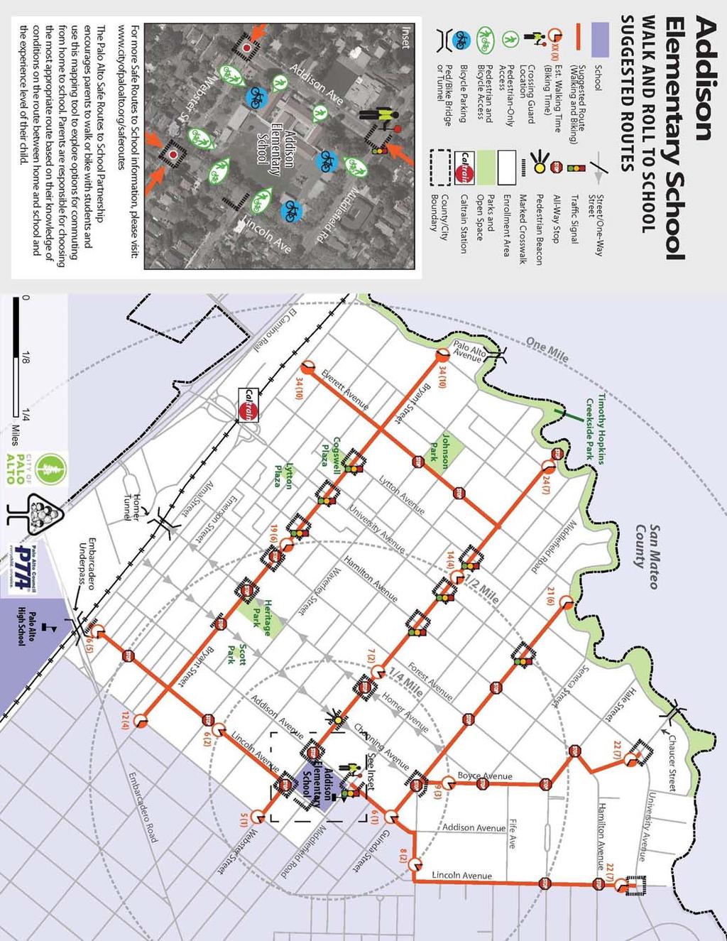
6
7
8
9
10
11
12
13
14
15
16
17

18
19
20
21
22
23
24
SECTION TRAFFIC REGULATIONS
 SECTION 01550 TRAFFIC REGULATIONS PART 1 - GENERAL 1.01 OBJECTIVES A. The Contractor shall provide for safe movement of vehicular, bicycle and pedestrian traffic, including persons with disabilities in
REVOCABLE PERMIT FOR STREET BANNER APPLICATION PACKAGE
 Development Engineering 300 Richards Blvd., 3rd Floor Sacramento, CA 95811 Engineering Services Division REVOCABLE PERMIT FOR STREET BANNER APPLICATION PACKAGE Phone: 916-808-8300 Fax: 916-808-1984 Preparation
TEMPORARY TRAFFIC CONTROL GUIDELINES FOR HIGHWAY-RAIL GRADE CROSSINGS
 TEMPORARY TRAFFIC CONTROL GUIDELINES FOR HIGHWAY-RAIL GRADE CROSSINGS 1.0 INTRODUCTION 1.1 Purpose The Southern California Regional Rail Authority (SCRRA) is the designated track owner of the Metrolink
FEDERAL HIGHWAY ADMINISTRATION APPLICATION
 FEDERAL HIGHWAY ADMINISTRATION APPLICATION REQUEST FOR PERMISSION TO EXPERIMENT WITH A BICYCLE BOX INTERSECTION TREATMENT Submitted by: City of Columbus Department of Public Service Date: June 26, 2009
Draft Final Report: South Palo Alto School Commute Safety Study
 Draft Final Report: South Palo Alto School Commute Safety Study Prepared for: The City of Palo Alto 1021-1839 F EHR & P EERS T R A N S P O R TAT I O N 3685 Mt. Diablo Blvd. #301 Lafayette, CA 94549 925-284-3200
0 CITY OF SANTA ANA 0
 : A traffic control plan (Plan) is required whenever work is to be performed within the public right-of-way and is deemed necessary by the City of Santa Ana's (City) Traffic Engineer. Work cannot start
Work Area Traffic Control Policies and Procedures
 Work Area Traffic Control Policies and Procedures August 2016 Traffic Operations 626 Linden Street P.O. Box 580 TABLE OF CONTENTS Introduction... 1 Applicability... 1 Goals... 1 Authority... 2 Planning...
Caltrans Sloat Boulevard Pedestrian Safety Project Response to Community Questions, Comments & Concerns
 Caltrans Sloat Boulevard Pedestrian Safety Project Response to Community Questions, Comments & Concerns Revised: May 10, 2016 The California Department of Transportation (Caltrans) is planning various
CONSTRUCTION ENCROACHMENT PERMIT APPLICATION AND PROCESSING INSTRUCTIONS
 'HYHORSPHQW (QJLQHHULQJ 5LFKDUGV %OYG UG )ORRU 6DFUDPHQWR &$ Phone: 916-808-8300 Fax: 916-808-1984 (QJLQHHULQJ 6HUYLFHV 'LYLVLRQ CONSTRUCTION ENCROACHMENT PERMIT APPLICATION AND PROCESSING INSTRUCTIONS
l Civil Engineering Group of PSRA Techn ical Plan Review Team. '\J \
 GOVERNMENT OF THE DISTRICT OF COLUMBIA District Department of Transportation Public Space Regulation Administration PSRA.. *.. d ~ oc == *. * GENERAL TRAFFIC CONTROL PLAN (TCP) SUBMITTAL GUIDELINES 18
TRANSPORTATION TRAINING TOPICS. April 6, 2010
 TRANSPORTATION TRAINING TOPICS April 6, 2010 Roles of Transportation Providers Context and Policy Makers Division of Transportation and Traffic Other City Operations Other Transportation Operators CMA
FROM: CITY MANAGER DEPARTMENT: PLANNING AND COMMUNITY ENVIRONMENT DATE: FEBRUARY 19, 2002 CMR:147:02 NEIGHBORHOOD TRAFFIC CALMING PROGRAM
 TO: HONORABLE CITY COUNCIL FROM: CITY MANAGER DEPARTMENT: PLANNING AND COMMUNITY ENVIRONMENT DATE: FEBRUARY 19, 2002 CMR:147:02 SUBJECT: NEIGHBORHOOD TRAFFIC CALMING PROGRAM This is an informational report
DRAFT - CITY OF MEDFORD TRANSPORTATION SYSTEM PLAN Roadway Cross-Sections
 Roadway Cross-Sections Medford s roadway cross-section standards apply to new and reconstructed roads. The crosssections take into consideration roadway function and operational characteristics, including
Temporary Traffic Control for Highway Work Zones
 Temporary Traffic Control for Highway Work Zones MONTHLY DELMARVA MISS UTILITY MEMBER MEETING MARCH 20, 2014 PRESENTED BY: Adam Weiser, P.E. PTOE Safety Programs Manager Delaware Department of Transportation
FROM: CITY MANAGER DEPARTMENT: PLANNING AND COMMUNITY ENVIRONMENT DATE: OCTOBER 4, 2004 CMR:432:04
 TO: HONORABLE CITY COUNCIL FROM: CITY MANAGER DEPARTMENT: PLANNING AND COMMUNITY ENVIRONMENT DATE: OCTOBER 4, 2004 CMR:432:04 SUBJECT: FINANCE COMMITTEE RECOMMENDATION TO ADOPT TRANSPORTATION STRATEGIC
TRAFFIC ACTION PLAN. Laurie Meadows Neighborhood CITY OF SAN MATEO
 TRAFFIC ACTION PLAN Laurie Meadows Neighborhood CITY OF SAN MATEO Draft January 2017 Table of Contents Introduction... 2 The Traffic Forum Process... 5 Neighborhood Traffic Issues... 7 Neighborhood Recommendations
Transportation Element
 Transportation Element Draft Comprehensive Plan 55 Draft Comprehensive Plan 56 Highlights of Change This Element will meet the State requirement for a Circulation Element of the Comprehensive Plan. The
PUBLIC COMMENTS ITEMS FOR CONSIDERATION/ACTION
 ATTACHMENT D Page 1 of 5 MINUTES OF THE COMPLETE STREETS COMMISSION (FORMERLY THE BICYCLE AND PEDESTRIAN ADVISORY COMMISSION) OF THE CITY OF LOS ALTOS, HELD ON WEDNESDAY, MAY 23, 2018 AT 7:00 P.M. AT THE
Bike San Mateo County San Mateo County Bicycle Plan Recommendations August 30, 2010
 Policy and Procedures Develop and Implement a Complete Streets Policy to comply with DD-64-R1 and AB1358 Commencing January 1, 2011, AB1358 requires that the legislative body of a city or county, upon
STANDARD SPECIFICATIONS FOR PUBLIC WORKS CONSTRUCTION CITY OF MANITOWOC, WISCONSIN SECTION 900 TRAFFIC CONTROL
 SECTION 900 TRAFFIC CONTROL STANDARD SPECIFICATIONS FOR PUBLIC WORKS CONSTRUCTION CITY OF MANITOWOC, WISCONSIN SECTION 900 TRAFFIC CONTROL Section Number Title 901 GENERAL 902 MATERIALS, EQUIPMENT, AND
AGENDA ITEM G-2 Public Works
 AGENDA ITEM G-2 Public Works STAFF REPORT City Council Meeting Date: 12/6/2016 Staff Report Number: 16-214-CC Regular Business: Approve the Oak Grove University Crane Bike Improvement Concept Plan, authorize
Work Area Traffic Control Policies and Procedures July 2017
 Work Area Traffic Control Policies and Procedures July 2017 Traffic Operations 626 Linden St, Fort Collins 80524 P.O. Box 580, Fort Collins, CO 80522 Phone: 970-221-6630 Fax: 970-221-6282 Email: FCWATC@fcgov.com
City of Elizabeth City Neighborhood Traffic Calming Policy and Guidelines
 City of Elizabeth City Neighborhood Traffic Calming Policy and Guidelines I. Purpose: The City of Elizabeth City is committed to ensure the overall safety and livability of residential neighborhoods. One
Appendix A. Knoxville TPO Greenway Signage Guidelines. Appendix A: Knoxville TPO Greenway Signage Guidelines Knox to Oak Ridge Greenway Master Plan
 Appendix A Knoxville TPO Greenway Signage Guidelines 75 Overview: Adequate signing and marking are essential on shared-use paths, especially to alert bicyclists to potential conflicts and to convey regulatory
Cycle Track Design Best Practices Cycle Track Sections
 Design Best Practices Sections It is along street segments where the separation and protection methods of cycle tracks offer more comfort than conventional bicycle lanes, and are more attractive to a wide
CITY OF KASSON TRANSPORTATION ALTERNATIVES KASSON SAFE ROUTES TO SCHOOL
 ve ha 8t G B A Mantorville Ave N 240th Ave 16th St NE 11th Ave NE K-M HIGH SCHOOL SUNRISE TRAIL TO MANTORVILLE MNTH 57 SUNSET TRAIL TO MANTORVILLE NE PARK 16TH ST NE TRAIL K-M ELEMENTARY SCHOOL K-M MIDDLE
CHAPTER 6H. TYPICAL APPLICATIONS
 2006 Edition Page 6H-1 CHAPTER 6H. TYPICAL APPLICATIONS Section 6H.01 Typical Applications Support: Whenever the acronym TTC is used in this Chapter, it refers to temporary traffic control. Standard: The
APPENDIX A: Complete Streets Checklist DRAFT NOVEMBER 2016
 APPENDIX A: Complete Streets Checklist DRAFT NOVEMBER 2016 Complete Streets Checklist MetroPlan Orlando s Complete Streets Checklist is an internal planning tool for staff to further implementation of
Hospital Link Project Project Update September 2017
 Hospital Link Project Project Update September 2017 General The project provides a link from Riverside Drive and the Transitway to the Hospital Link Road. Construction is well underway. Read on for important
Los Altos Hills Town Council - June 18, 2015 Palo Alto City Council June 22, AGENDA ITEM #2.B Presentation
 Los Altos Hills Town Council - June 18, 2015 Palo Alto City Council June 22, 2015 AGENDA ITEM #2.B Presentation Previous Presentations Los Altos Hills Town Council in May 2014 and February 2015 Palo Alto
City of Coronado Bicycle Map, Schools, Traffic Signals and Crossing Guard Locations
 City of Coronado Bicycle Map, Schools, Traffic Signals and Crossing Guard Locations Early Childhood Development Center Crossing Guard - AM Crossing Guard - PM Coronado Middle Village Elementary Coronado
Appendix C. Bicycle Route Signage
 Appendix C Bicycle Route Signage This page intentionally left blank. APPENDIX C - BICYCLE ROUTE AND WAYFINDING SIGNAGE Bicycle route signs are wayfinding signs that guide bicyclists along preferred, designated
TRAFFIC ACTION PLAN. North Central Neighborhood CITY OF SAN MATEO
 TRAFFIC ACTION PLAN North Central Neighborhood CITY OF SAN MATEO Draft February 2017 Table of Contents Introduction... 1 The Traffic Forum Process... 4 Neighborhood Traffic Issues... 6 Neighborhood Recommendations
California Department of Transportation, District 4. Sloat Boulevard Project Skyline Blvd. to 19 th Ave. Community Update January 13, 2016
 California Department of Transportation, District 4 Sloat Boulevard Project Skyline Blvd. to 19 th Ave. Community Update January 13, 2016 Agenda Welcome and introductions Project overview, history and
Appendix T CCMP TRAIL TRAFFIC & TRANSPORTATION DESIGN STANDARD
 Appendix T CCMP 3.3.4 TRAIL TRAFFIC & TRANSPORTATION DESIGN STANDARD 3.3.4 Trail Traffic and Transportation Design Multi-use trails have certain design standards, which vary depending on the agency that
MUTCD Part 6G: Type of Temporary Traffic Control Zone Activities
 MUTCD Part 6G: Type of Temporary Traffic Control Zone Activities 6G.01 Typical Applications Each temporary traffic control (TTC) zone is different. Many variables, such as location of work, highway type,
City of Albert Lea Policy and Procedure Manual 4.10 ALBERT LEA CROSSWALK POLICY
 4.10 ALBERT LEA CROSSWALK POLICY PURPOSE: Pedestrian crosswalks are an integral part of our transportation infrastructure. To be effective and promote safety, marked crosswalks must be installed after
4.11 Transportation and Traffic
 4.11.1 Introduction This section evaluates whether implementation of the Russian River Estuary Management Project (Estuary Management Project) would result in potential adverse impacts related to transportation
3.9 Recreational Trails and Natural Areas
 3.9 Recreational Trails and Natural Areas 3.9.1 Introduction Parks and other recreational facilities such as trails, bicycle routes, and open space are important community resources. This section discusses
MUNICIPALITY OF ANCHORAGE TRAFFIC CODE UPDATE MASTER RECOMMENDATION REPORT: 9.14, 9.16, 9.18
 MUNICIPALITY OF ANCHORAGE TRAFFIC CODE UPDATE MASTER RECOMMENDATION REPORT: 9.14, 9.16, 9.18 Report Date: Please send all recommendations for update to Shane Locke (343-8413, lockesr@muni.org) 8-Apr-09
Emergency Response Support Signage on Multi-Use Trails Plan
 DRAFT ( ) Emergency Response Support Signage on Multi-Use Trails Plan Prepared for: SATS Multi-Use Trails Jurisdictions Committee Table of Contents Introduction... 3 Mileage Markers... 4 Rest Stop Identifiers...
REVISION 2 VIRGINIA WORK AREA PROTECTION MANUAL. Ginger Quinn & Paul Kelley April 11, 2018
 REVISION 2 VIRGINIA WORK AREA PROTECTION MANUAL Ginger Quinn & Paul Kelley April 11, 2018 ADA & District Traffic Engineer Added in various sections Work Zone Pedestrian and Bicycle Guidance document VDOT
PROCEDURE FOR ACCOMMODATING PEDESTRIANS IN WORK ZONES FOR CONSTRUCTION AND MAINTENANCE
 PROCEDURE FOR ACCOMMODATING PEDESTRIANS IN WORK ZONES FOR CONSTRUCTION AND MAINTENANCE A.1 STANDARD Measures shall be taken to accommodate pedestrian traffic through and/or around Work Zones for Construction
COMMUNITY MEETING August 23, 2018
 COMMUNITY MEETING August 23, 2018.. 1 Agenda Welcome & Introduction Project Background & Purpose Project Overview Q & A Stations Charleston / Meadow Palo Alto City-Wide Tunnel Ideas No Longer Considered
COMPLETE STREETS DURING CONSTRUCTION
 COMPLETE STREETS DURING CONSTRUCTION MAINTAINING ACCESSIBILITY FOR ALL Presented by Robbie Burgess, P.E., PTOE Associate Principal Construction Services Manager Howard Stein Hudson rburgess@hshassoc.com
ATTACHMENT NO. 11. RRLRT No. 2. Railroad / Light Rail Transit Technical Committee TECHNICAL COMMITTEE: Busway Grade Crossings STATUS/DATE OF ACTION
 ATTACHMENT NO. 11 RRLRT No. 2 TECHNICAL COMMITTEE: TOPIC: Railroad / Light Rail Transit Technical Committee Busway Grade Crossings STATUS/DATE OF ACTION RRLRT TC Draft: 06/23/2011 RRLRT TC Approval: 06/27/2014
I will attend tonight's meeting to summarize this proposal during my public comment. Thank you.
 Grossman, Rachel M From: Andrew Boone Sent: Wednesday, January 11, 2012 2:29 PM To: thprop@earthlink.net; nate.menlopark@gmail.com; Bianca.walser@gmail.com; Mshiu147@gmail.com; menlo.commish.mueller@gmail.com;
ARLINGTON COUNTY PAVEMENT MARKING SPECIFICATIONS
 DEPARTMENT OF ENVIRONMENTAL SERVICES ARLINGTON COUNTY PAVEMENT MARKING SPECIFICATIONS MAY 2017 Table of Contents 1. General... 2 2. Design Criteria... 3 3. Marking Plan Preparation... 4 Exhibits... 5 MK
TOWN OF CHAPEL HILL POLICY AND PROCEDURES FOR TRAFFIC CALMING MEASURES
 TOWN OF CHAPEL HILL POLICY AND PROCEDURES FOR TRAFFIC CALMING MEASURES (Adopted by the Town Council on June 30, 2004) (Revised December 6, 2010) (Revised February 8, 2016) POLICY AND PROCEDURES FOR TRAFFIC
Double the amount of bicycle ridership while at the same time reducing the number of bicycle crashes by one-third.
 CHAPTER 6 Recommended Policies and Action Items To achieve the goals stated in Chapter 1 and guide implementation of the Bicycle Plan, policies and action items have been identified. They are presented
Bicycle. for parents and youth
 Bicycle & Pedestrian Safety for parents and youth A project of Traffic Safe Communities Network (TSCN) in Santa Clara County In collaboration with the Trauma Center at Stanford University Medical Center,
REGIONAL BICYCLE AND PEDESTRIAN DESIGN GUIDELINES
 REGIONAL BICYCLE AND PEDESTRIAN DESIGN GUIDELINES November 16, 2011 Deb Humphreys North Central Texas Council of Governments Bicycle and Pedestrian Advisory Committee Snapshot of the Guide 1. Introduction
Santa Clara I-280 CORRIDOR STUDY
 Santa Clara I-280 CORRIDOR STUDY OCTOBER 2017 PREPARED BY: 1.1 Background The I-280 Corridor Study within Santa Clara County is a high-level highway planning study led by the Santa Clara VTA, in partnership
CHAPTER 3. Transportation and Circulation
 CHAPTER 3 Transportation and Circulation 3.0 TRANSPORTATION AND CIRCULATION This chapter evaluates traffic circulation, transit, parking, pedestrian, bicycle, and rail operational conditions in the Project
DEFINITIONS Activity Area - Advance Warning Area Advance Warning Sign Spacing Advisory Speed Approach Sight Distance Attended Work Space
 DEFINITIONS Activity Area - that part of a TTC zone activity area where the work actually takes place. It consists of the work space, traffic space and one or more buffer spaces. Advance Warning Area -
ADA on Construction. Guidance for Section C Plan Preparers
 ADA on Construction Guidance for Section C Plan Preparers Some impacts cannot be avoided and those impacts apply to residents, businesses, motorists, and pedestrians alike. However, good planning can minimize
SAN FRANCISCO MUNICIPAL TRANSPORTATION AGENCY
 THIS PRINT COVERS CALENDAR ITEM NO. : 10.3 DIVISION: Sustainable Streets Division BRIEF DESCRIPTION: SAN FRANCISCO MUNICIPAL TRANSPORTATION AGENCY Approving traffic and parking modifications to install
Accommodating Pedestrians in the Work Zone
 Accommodating Pedestrians in the Work Zone Guidance for Section C Plan Preparers Some impacts cannot be avoided and those impacts apply to residents, businesses, motorists, and pedestrians alike. However,
122 Avenue: 107 Street to Fort Road
 : 107 Street to Fort Road November 24, 2015 4:30 8:00 p.m. Meeting Purpose Summarize project work completed to date Share results of public input from Phase 1 Share the draft concept plan and proposed
Traffic Control Inspection Checklist Segment:
 Traffic Control Inspection Checklist Segment: Simon Contractors Simon Contractors Originator: Description Reviewed by: Initials Date Distribution: Traffic Quality Manager, Site Assistant Traffic Manager
SAN FRANCISCO MUNICIPAL TRANSPORTATION AGENCY BOARD OF DIRECTORS. RESOLUTION No
 SAN FRANCISCO MUNICIPAL TRANSPORTATION AGENCY BOARD OF DIRECTORS RESOLUTION No. 15-031 WHEREAS, Transportation Code Division II, Section 909 authorizes the Director of Transportation to install and permit
TEMPORARY OCCUPANCY PERMITS. Street Space, Additional Street Space and Temporary Occupancy Permits PUBLIC WORKS CODE : ARTICLE 15, SEC.
 TEMPORARY OCCUPANCY PERMITS Street Space, Additional Street Space and Temporary Occupancy Permits PUBLIC WORKS CODE : ARTICLE 15, SEC. 724 Difference between the 3 permits. Who would apply for the permit?
Tom Brohard and Associates
 Tom Brohard and Associates Coalition for Safe and Sensible Zoning PO Box 60383 Palo Alto, CA 94306 SUBJECT: Review of the Proposed Development Project at 567-595 Maybell Avenue in the City of Palo Alto
TRAFFIC CALMING GUIDE FOR TORONTO CITY OF TORONTO TRANSPORTATION SERVICES DIVISION
 TRAFFIC CALMING GUIDE FOR TORONTO CITY OF TORONTO TRANSPORTATION SERVICES DIVISION CITY OF TORONTO TRANSPORTATION SERVICES DIVISION 2016 TRAFFIC CALMING GUIDE FOR TORONTO TABLE OF CONTENTS Introduction
Guide for Law Enforcement Personnel in Work Zones
 Guide for Law Enforcement Personnel in Work Zones Table of Contents Introduction........................... 3 Roles and Responsibilities................ 5 Most Common Law Enforcement Services in Work
TRAFFIC ACTION PLAN. Central Neighborhood CITY OF SAN MATEO
 TRAFFIC ACTION PLAN Central Neighborhood CITY OF SAN MATEO Draft January 2017 Table of Contents Introduction... 1 The Traffic Forum Process... 4 Neighborhood Traffic Issues... 7 Neighborhood Recommendations
Welcome and Purpose of Meeting
 Welcome and Purpose of Meeting Waterfront Trail Connection Lake Shore Cycling Improvements There is a gap in the Waterfront trail along Lake Shore Blvd West between Norris and First St We are looking at
2017 Temporary traffic control guidelines for pedestrians. v.2
 2017 Temporary traffic control guidelines for pedestrians v.2 Temporary Traffic Control Guidelines for Pedestrians (2017) The safety and mobility of pedestrians, cyclists and motorists must be considered
City and County of San Francisco. Regulations for Working in San Francisco Streets
 City and County of San Francisco Regulations for Working in San Francisco Streets January 2012 8 th Edition *Includes updated contact info as of 03/2016 PARKING AND TRAFFIC REGULATIONS FOR WORKING IN SAN
CHAPTER 6H. TYPICAL APPLICATIONS
 Section 6H.01 Typical Applications Support: CHAPTER 6H. TYPICAL APPLICATIONS Chapter 6G contains discussions of typical temporary traffic control activities. Chapter 6H presents typical applications for
CITY OF LOS ALTOS CITY COUNCIL MEETING May 10, 2016
 CITY OF LOS ALTOS CITY COUNCIL MEETING May 10, 2016 CONSENT CALENDAR Agenda Item # 6 SUBJECT: Adopt Resolution No. 2016-09, approving Engineering and Traffic Surveys at 26 street segments in Los Altos;
San Rafael School District. Task Force Meeting Notes. November 5, 2012
 San Rafael School District Task Force Meeting Notes November 5, 2012 Attendees (8) Wendi Kallins Program Director for Safe Routes to Schools; Laura Kelly Volunteer Liaison for Safe Routes to Schools; Leslie
Duwamish Way-finding and CTR Report
 V. North Tukwila When the North Tukwila Manufacturing and Industrial Center was designated in 1992 as part of the region s land use and transportation plan, the plan called for the area to set a light-rail
Lessons Learned from Cycle Tracks (Class IV Bikeways) Design Practice
 Design Practice") Lessons Learned from Cycle Tracks (Class IV Bikeways) Design Practice By: Min Zhou, P.E., Principal/Vice President KOA Corporation 1 What is a Cycle Track (Class IV) TYPICAL BIKEWAY CLASSIFICATION CLASS
Lessons Learned from Cycle Tracks (Class IV Bikeways) Design Practice By: Min Zhou, P.E., Principal/Vice President KOA Corporation 1 What is a Cycle Track (Class IV) TYPICAL BIKEWAY CLASSIFICATION CLASS
Crosswalk Policy Revisions & Pedestrian & Bicycle Connection Plans. Presentation to Sanibel City Council July 16, 2013
 Crosswalk Policy Revisions & Pedestrian & Bicycle Connection Plans Presentation to Sanibel City Council July 16, 2013 Outline Crosswalk Policy Revisions Minimum Standards Goals and Objectives Pedestrian
The Wiggle Route in Context
 The Wiggle Route in Context In a city of hills, the Wiggle is an important route because it winds its way along the flattest streets from Market to the Panhandle, bringing residents to local parks and
Transportation 6. A. Transit Center Circulation and Access. 1. Transit Center Circulation
 Transportation 6 This chapter describes the transportation system in and around the Hillsdale Station Area, with a focus on the Transit Center at the relocated Hillsdale Caltrain Station. The transportation
COUNCIL ACTION FORM SUBJECT: REQUESTS FROM AMES VELO FOR AMES GRAND PRIX
 ITEM # 11 a & b DATE: 04-10-18 COUNCIL ACTION FORM SUBJECT: REQUESTS FROM AMES VELO FOR AMES GRAND PRIX BACKGROUND: The Ames Velo organization has proposed hosting its second Annual Ames Grand Prix bicycle
Including Revision 1 dated May 2012 and Revision 2 dated May 2012
 Including Revision 1 dated May 2012 and Revision 2 dated May 2012 Page 634 2009 Edition Notes for Figure 6H-1 Typical pplication 1 Work eyond the Shoulder 1. If the work space is in the median of a divided
TABLE OF CONTENTS. Executive Summary
 Executive Summary Background... ES-1 Pedestrian Network... ES-2 Bikeway Network... ES-2 Collision History... ES-2 Public Input... ES-4 Conclusions and Recommendations... ES-4 1. Introduction and Setting
Richmond-Adelaide Cycle Tracks
 Public Drop-In Event Richmond-Adelaide Cycle Tracks June 25, 2018 12:00 p.m. 3:00 p.m. 4:30 p.m. 7:30 p.m. Metro Hall, Rotunda 55 John Street 1 Purpose of Event In Scope Communicate an update about the
NOTICE OF REVISED PROCEDURES FOR REVIEW OF TEMPORARY TRAFFIC CONTROL PLANS
 City of Santa Monica Planning and Community Development Department Transportation Engineering & Management Division NOTICE OF REVISED PROCEDURES FOR REVIEW OF TEMPORARY TRAFFIC CONTROL PLANS Effective
Multi-Modal Traffic Analysis. Parisi and Associates
 Mill Valley to Corte Madera Bicycle and Pedestrian Corridor Study Appendix D: Multi-Modal Traffic Analysis Prepared by Parisi and Associates August 2009 Appendix D - Multi-Modal Traffic Analysis Table
City of Turlock Traffic Calming Program
 Table of Contents Introduction... 3 Definitions... 3 Purpose... 3 Goals and Objectives... 3 Policy Statements... 4 Minimum Qualifying Criteria... 6 Traffic Calming Request Process... 7 Step No. 1: Complete
4.13 TRANSPORTATION AND CIRCULATION
 Ascent Environmental 4.13 TRANSPORTATION AND CIRCULATION 4.13.1 Introduction This section describes the existing transportation setting in the project area, including current levels of service, bicycle
STREET and UTILITY REPAIRS WORK AREA PROTECTION GUIDE
 STREET and UTILITY REPAIRS WORK AREA PROTECTION GUIDE May 2006 Street and Utility Repairs Work Area Protection Guide TABLE OF CONTENTS 1. Introduction... 1 2. Typical Applications... 11 2.1 Use of Hand-Signaling
SAN FRANCISCO MUNICIPAL TRANSPORTATION AGENCY
 THIS PRINT COVERS CALENDAR ITEM NO. : 10.2 DIVISION: Sustainable Streets BRIEF DESCRIPTION: SAN FRANCISCO MUNICIPAL TRANSPORTATION AGENCY Adopting Conceptual Proposal for Streetscape Improvements to Broadway,
4 DISRUPTION MANAGEMENT PLAN HIGHWAY 7 RAPIDWAY CONSTRUCTION BETWEEN BAYVIEW AVENUE AND WARDEN AVENUE TOWNS OF MARKHAM AND RICHMOND HILL
 4 DISRUPTION MANAGEMENT PLAN HIGHWAY 7 RAPIDWAY CONSTRUCTION BETWEEN BAYVIEW AVENUE AND WARDEN AVENUE TOWNS OF MARKHAM AND RICHMOND HILL The Transportation Services Committee recommends the adoption of
Draft North Industrial Area-Wide Traffic Plan
 Summary of North Industrial and Hudson Bay Industrial Recommended Improvements Table 1. Summary of s Item Location 1 2 3 4 5 6 7 8 9 10 11 12 Millar Ave north of 51st St Super 8 Motel back lane 400 Block
Bicyclist Signing Guidelines
 Bicyclist Signing Guidelines April, 2009 1 Introduction This paper describes the Montana Department of Transportation s (MDT) current practices related to bicyclist safety and signing issues and presents
TRAFFIC CALMING POLICY & PROCEDURES
 TRAFFIC CALMING POLICY & PROCEDURES AS ADOPTED BY MONTCLAIR TOWNSHIP COUNCIL AUGUST 4, 2009 TABLE OF CONTENTS 1. INTRODUCTION... 2 Purpose... 2 Traffic Calming Definition... 2 Statement Of Township Council
5. RUNNINGWAY GUIDELINES
 5. RUNNINGWAY GUIDELINES These guidelines should be considered collectively when making runningway decisions. A runningway is the linear component of the transit system that forms the right-of-way reserved
Temporary Traffic Control Manual. First Edition
 Temporary Traffic Control Manual First Edition Engineering Judgement The 2009 MUTCD (Arizona Supplement) states in Section 1A.13 (64), Engineering Judgement the evaluation of available pertinent information,
Chapter 2: Standards for Access, Non-Motorized, and Transit
 Standards for Access, Non-Motorized, and Transit Chapter 2: Standards for Access, Non-Motorized, and Transit The Washtenaw County Access Management Plan was developed based on the analysis of existing
Meadow Woods Elementary School
 Drag and drop pic and stretch/crop to the limits of the blue rectangle (delete this text box) Meadow Woods Elementary School Drag and drop pic and stretch/crop to the limits of the blue rectangle (delete
Traffic Circulation & Pedestrian Safety Study
 Lyons Township High School North Campus La Grange, Illinois Parking Lot Vaughan Building N Main Building Prepared for: Prepared by: July 23, 2015 Contents List of Figures, iii 1. Introduction...1 2. Existing
MANUAL OF TEMPORARY TRAFFIC CONTROL ON CITY STREETS
 MANUAL OF TEMPORARY TRAFFIC CONTROL ON CITY STREETS PUBLIC WORKS DEPARTMENT 2015 REVISION 1-2016 REVISION SUMMARY - MARCH 2016 Introduction 1.05 - Specifications for Traffic Control Devices Temporary Traffic
OneBayArea Grant Application
 OneBayArea Grant Application ER Taylor Elementary School Safe Routes to School Project Submitted by the San Francisco Department of Public Works To the San Francisco County Transportation Authority April
Residential Traffic Calming Program Guide. Town of Ashland, Virginia
 Residential Traffic Calming Program Guide Town of Ashland, Virginia August 1, 2006 TABLE OF CONTENTS A. INTRODUCTION... 1 B. GOALS... 1 C. CRITERIA... 1 D. IDENTIFYING NEIGHBORHOOD TRAFFIC CONCERNS...
Magnolia Place. Traffic Impact Analysis. Prepared for: City of San Mateo. Prepared by: Hexagon Transportation Consultants, Inc.
 Magnolia Place Traffic Impact Analysis Prepared for: City of San Mateo Prepared by: Hexagon Transportation Consultants, Inc. Updated January 4, 2010 Table of Contents 1. Introduction...1 2. Existing Conditions...6