BOARD OF ALDERMEN. Regular Meeting Tuesday, February 11, :00 p.m. Council Chambers Branson City Hall 110 W. Maddux
|
|
|
- Robyn McLaughlin
- 5 years ago
- Views:
Transcription

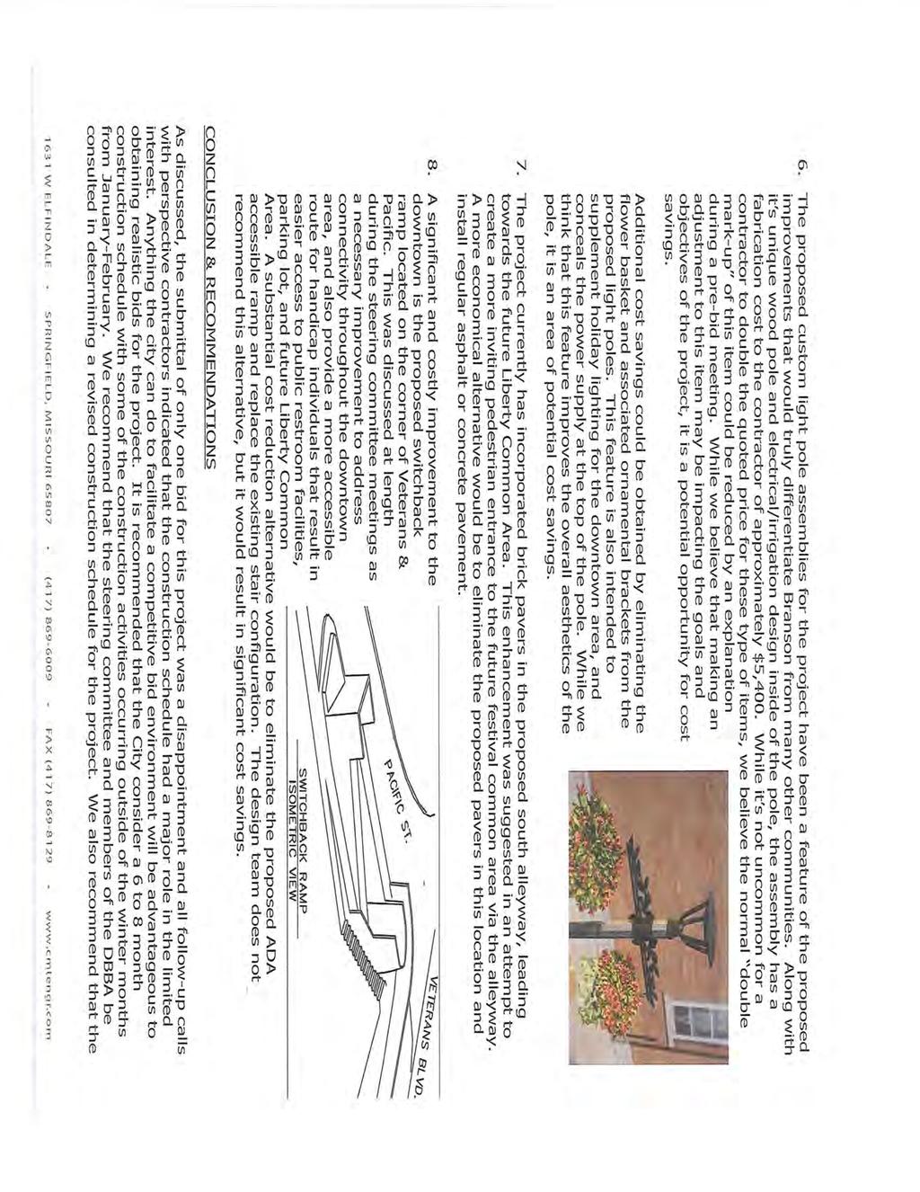
1 NOTICE OF MEETING CITY OF BRANSON BOARD OF ALDERMEN Regular Meeting Tuesday, February 11, :00 p.m. Council Chambers Branson City Hall 110 W. Maddux February 11, 2014 Board of Aldermen Agenda Page 1 of 4 Where Values are the Difference FEBRUARY: LEADERSHIP Exhibiting a positive example in leading others toward achievement
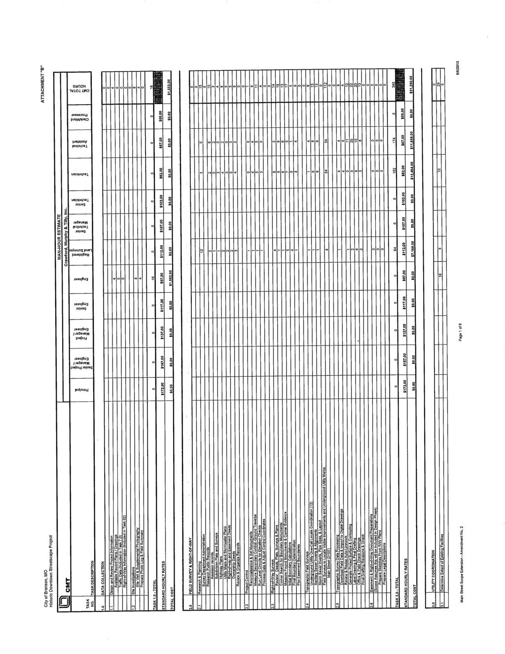
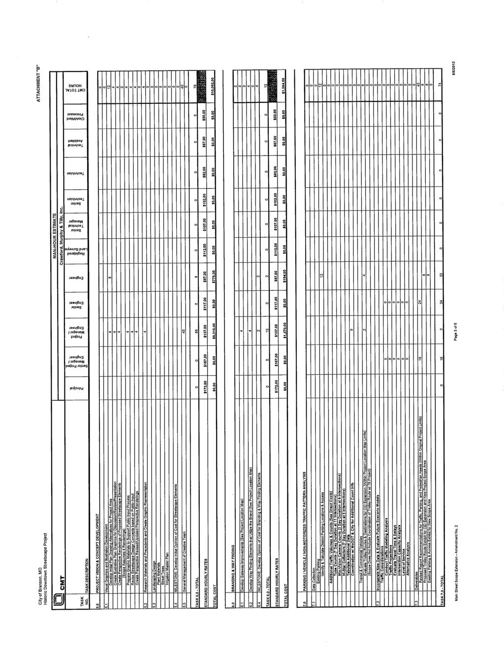
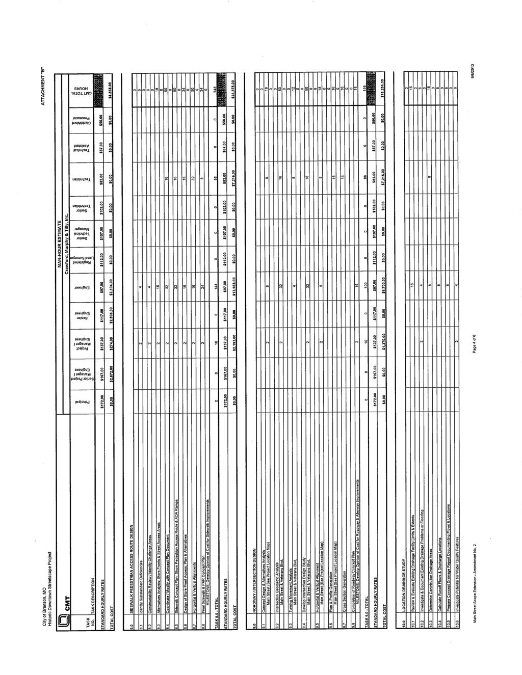
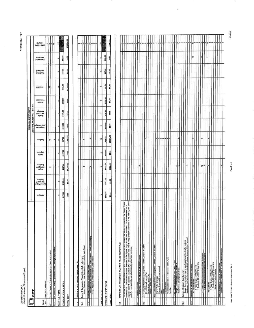
2 BRANSON BOARD OF ALDERMEN AGENDA February 11, :00 p.m. Meeting Called to Order Pledge of Allegiance Invocation Ted Martin Roll Call Employee of the Month Roger Hunzeker of the Parks and Recreation Department to be presented by Alderman Rick Davis. PUBLIC COMMENT: To speak during public comment, please sign the speaker sign-up sheet located at the front door of the council chambers prior to the start of the meeting. CONSENT AGENDA: 1) Approval of Board of Aldermen Minutes: a) January 23, 2014 Study Session b) January 28, 2014 Regular Meeting 2) Acknowledge Receipt of Minutes: a) Capital Improvement Committee meeting of January 13, 2014 b) Outside Agency Funding Committee meeting of January 29, ) Final Reading of Bill No approving Contract Amendment No. 3 to the agreement for professional consultant services between the City of Branson and Crawford, Murphy & Tilly, Inc. for the Historic Downtown Streetscape Project and authorizing the Mayor to execute the contract. 4) Final Reading of Bill No approving an amendment to the contract with World Wide Technology pertaining to the purchase of computer hardware and authorizing the Mayor to execute the contract. 5) Final Reading of Bill No accepting the proposal of Carson-Mitchell, Inc. pertaining to Historic Downtown Gateway Project and authorizing the Mayor to execute the contract. February 11, 2014 Board of Aldermen Agenda Page 2 of 4 Where Values are the Difference FEBRUARY: LEADERSHIP Exhibiting a positive example in leading others toward achievement
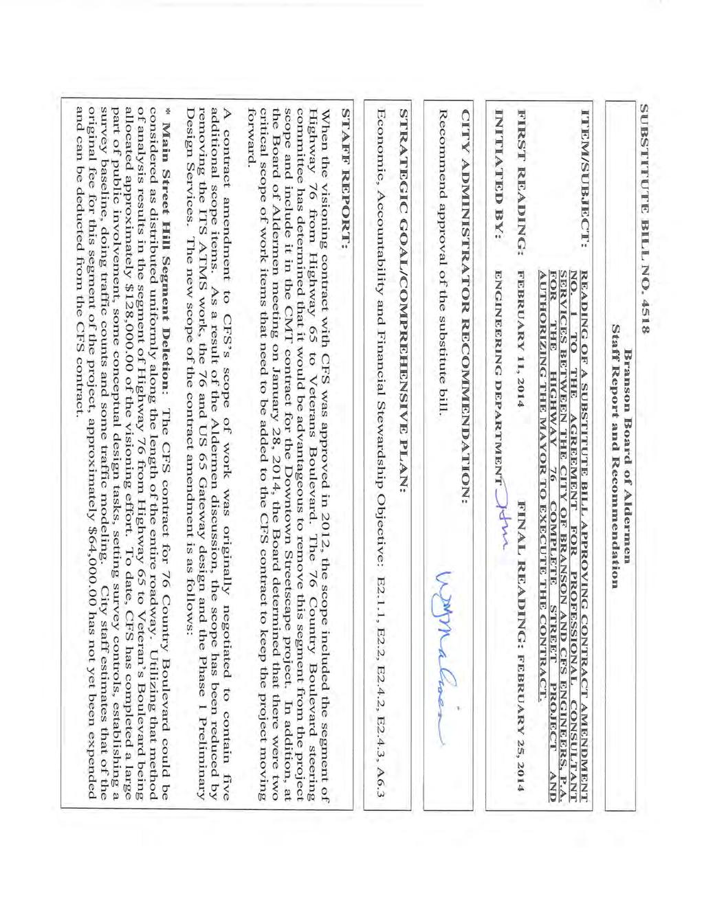
3 REGULAR: 6) First Reading of Bill No approving Contract Amendment No. 1 to the agreement for professional consultant services between the City of Branson and CFS Engineers, P.A. for the Highway 76 Complete Street Project and authorizing the Mayor to execute the contract. (Postponed from the January 28, 2014 meeting) 7) First Reading of Substitute Bill No approving Contract Amendment No. 1 to the agreement for professional consultant services between the City of Branson and CFS Engineers, P.A. for the Highway 76 Complete Street Project and authorizing the Mayor to execute the contract. 8) First Reading of Bill No approving the renewal of a contract with Ozarks Coca Cola/Dr. Pepper Bottling Company to provide drink items for vending and resale at the RecPlex and authorizing the Mayor to execute the contract. 9) First Reading of Bill No amending the contract with Radiophone Engineering, Inc. to provide communications maintenance and equipment and authorizing the Mayor to execute the contract. BID AWARDS: 10) First Reading of Bill No accepting the proposal of Ozarks Area Community Action Corporation (OACAC) pertaining to the provision of services to provide temporary emergency help for the needy and authorizing the Mayor to execute the contract. 11) First Reading of Bill No accepting the proposal of Faith Community Health Center, Inc. pertaining to the provision of services to provide temporary emergency help for the needy and authorizing the Mayor to execute the contract. 12) First Reading of Bill No accepting the proposal of The Women s Crisis Center of Taney County, Inc. pertaining to the provision of services to provide temporary emergency help for the needy and authorizing the Mayor to execute the contract. 13) First Reading of Bill No accepting the proposal of Christian Action Ministries (CAM) pertaining to the provision of services to provide temporary emergency help for the needy and authorizing the Mayor to execute the contract. 14) First Reading of Bill No accepting the proposal of Branson Arts Council pertaining to the provision of services for Community Arts and Cultural Activities and authorizing the Mayor to execute the contract. 15) First Reading of Bill No accepting the proposal of Mercy Occupational Health for annual firefighter physicals and immunizations and authorizing the Mayor to execute the contract. February 11, 2014 Board of Aldermen Agenda Page 3 of 4 Where Values are the Difference FEBRUARY: LEADERSHIP Exhibiting a positive example in leading others toward achievement
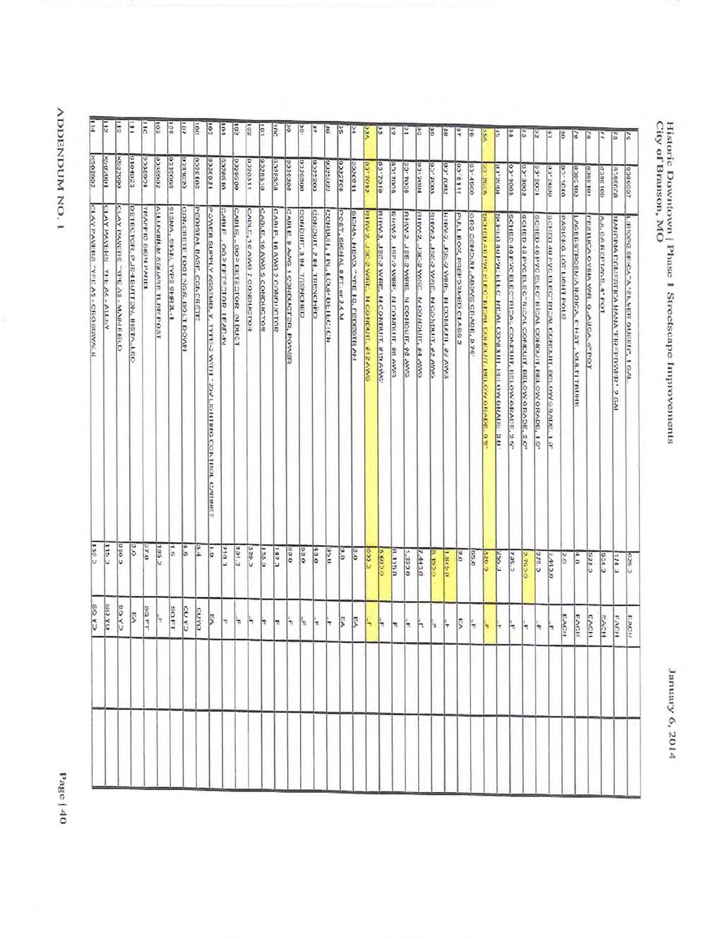
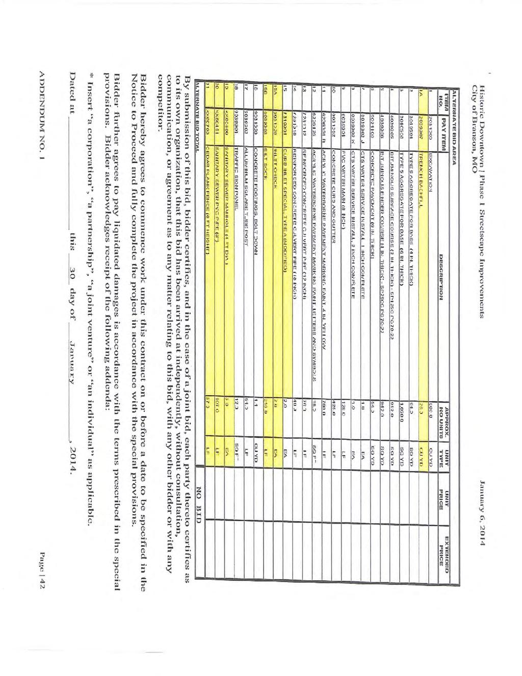
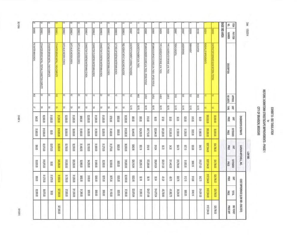
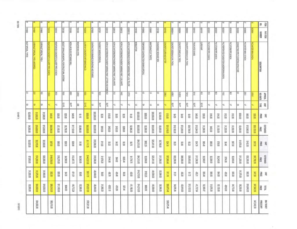
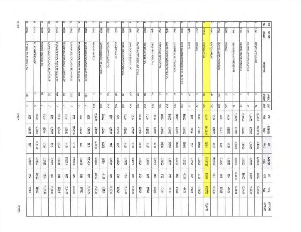
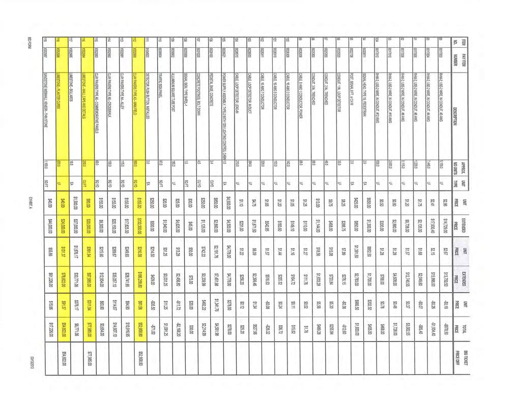
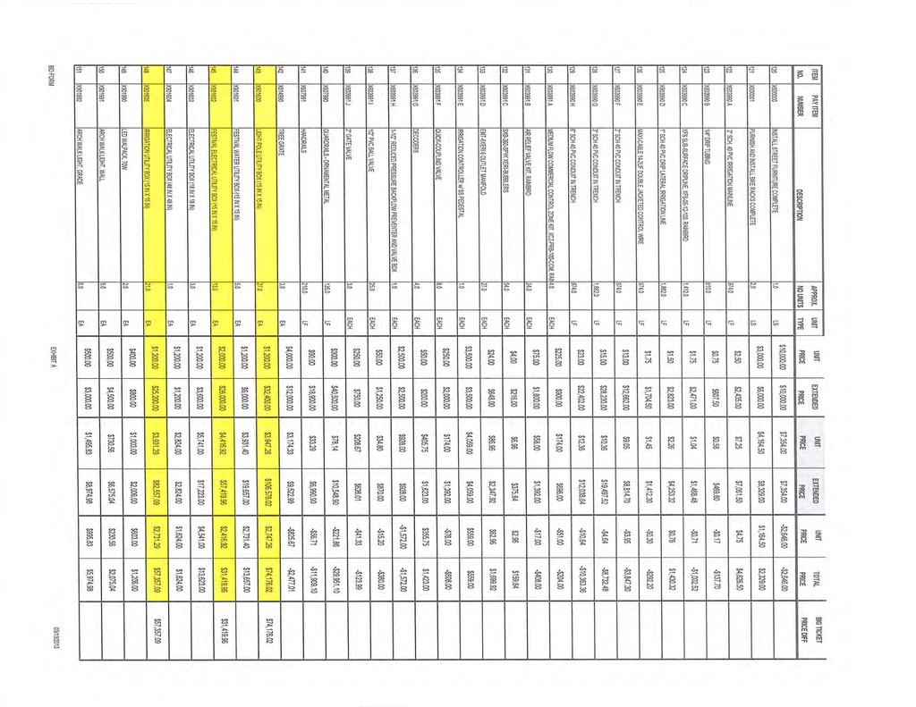
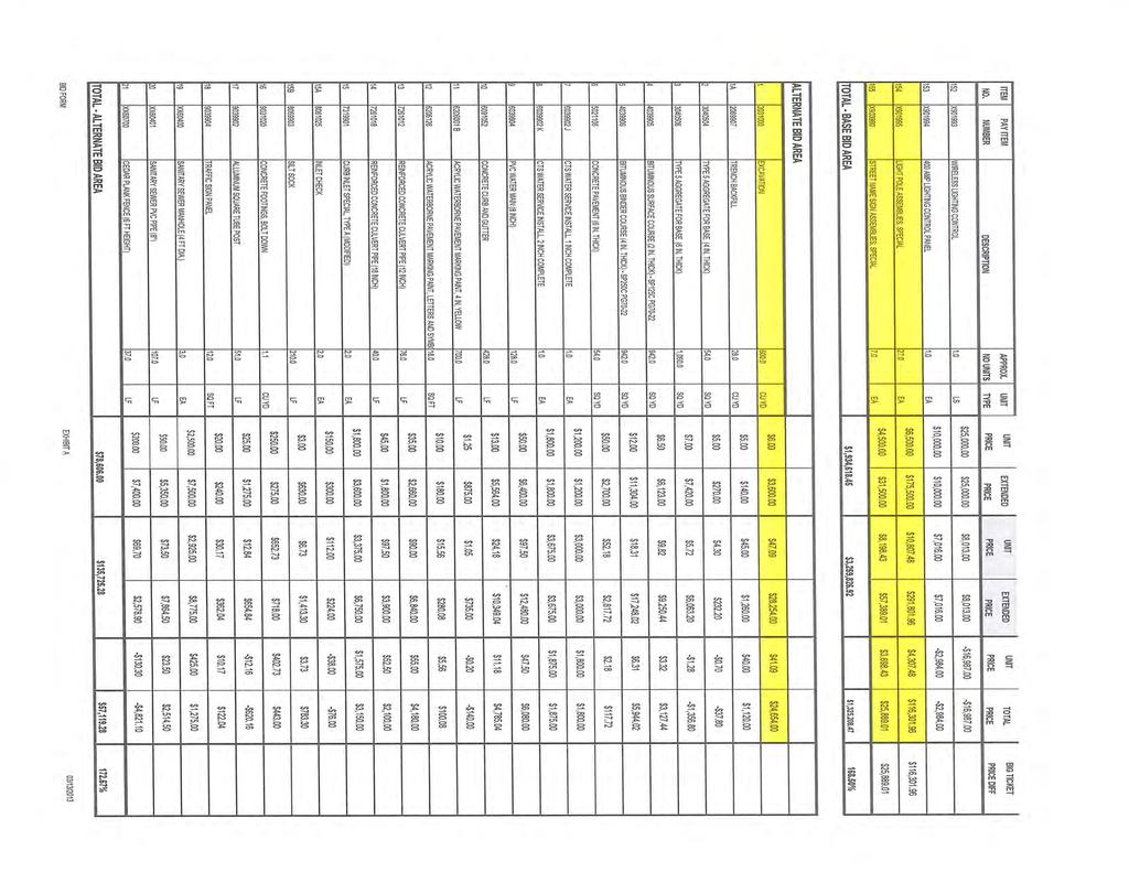
4 16) First Reading of Bill No accepting the proposal of Murphy Tractor & Equipment Co. pertaining to the purchase of a backhoe loader and authorizing the Mayor to execute the contract. APPOINTMENTS: 17) Appointments. [Biographies] OTHER BUSINESS: 18) Discussion of Cox Hospital and MoDOT land and easement transfers in connection with the expansion of the hospital. [Exhibit 1] [Exhibit A] [Exhibit B] [Exhibit C] [Exhibit D] 19) Update on Historic Downtown Streetscape. [Bid Tabulation] MAYOR/CITY ALDERMEN/CITY ADMINISTRATOR S REPORTS ADJOURN INTO EXECUTIVE SESSION Closed Executive Session pursuant to RSMo for litigation and RSMo for personnel. ADJOURN February 11, 2014 Board of Aldermen Agenda Page 4 of 4 Where Values are the Difference FEBRUARY: LEADERSHIP Exhibiting a positive example in leading others toward achievement
5
6
7
8

9
10
11
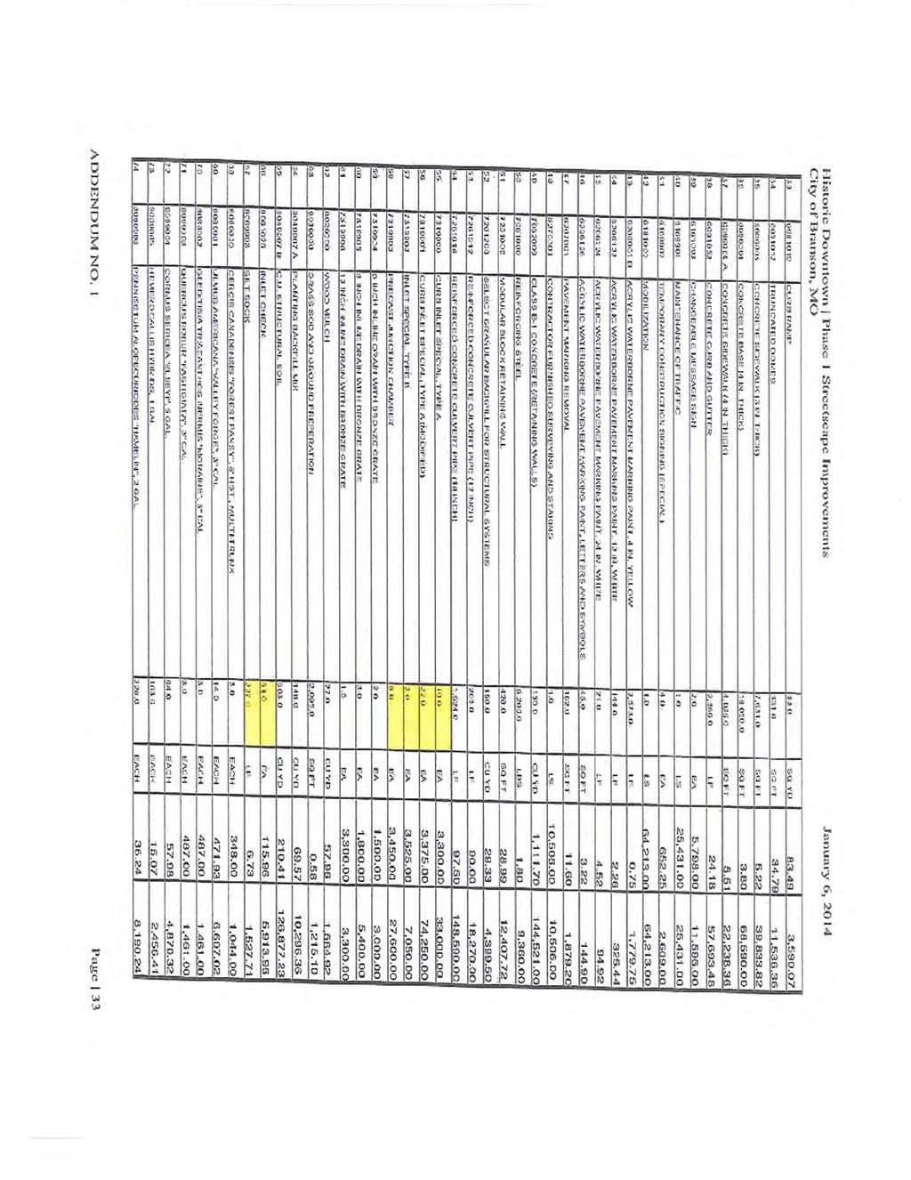
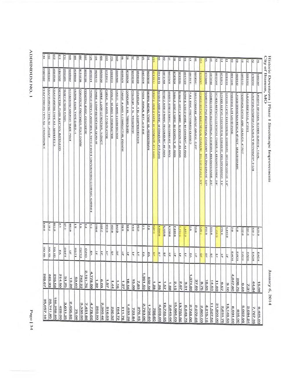
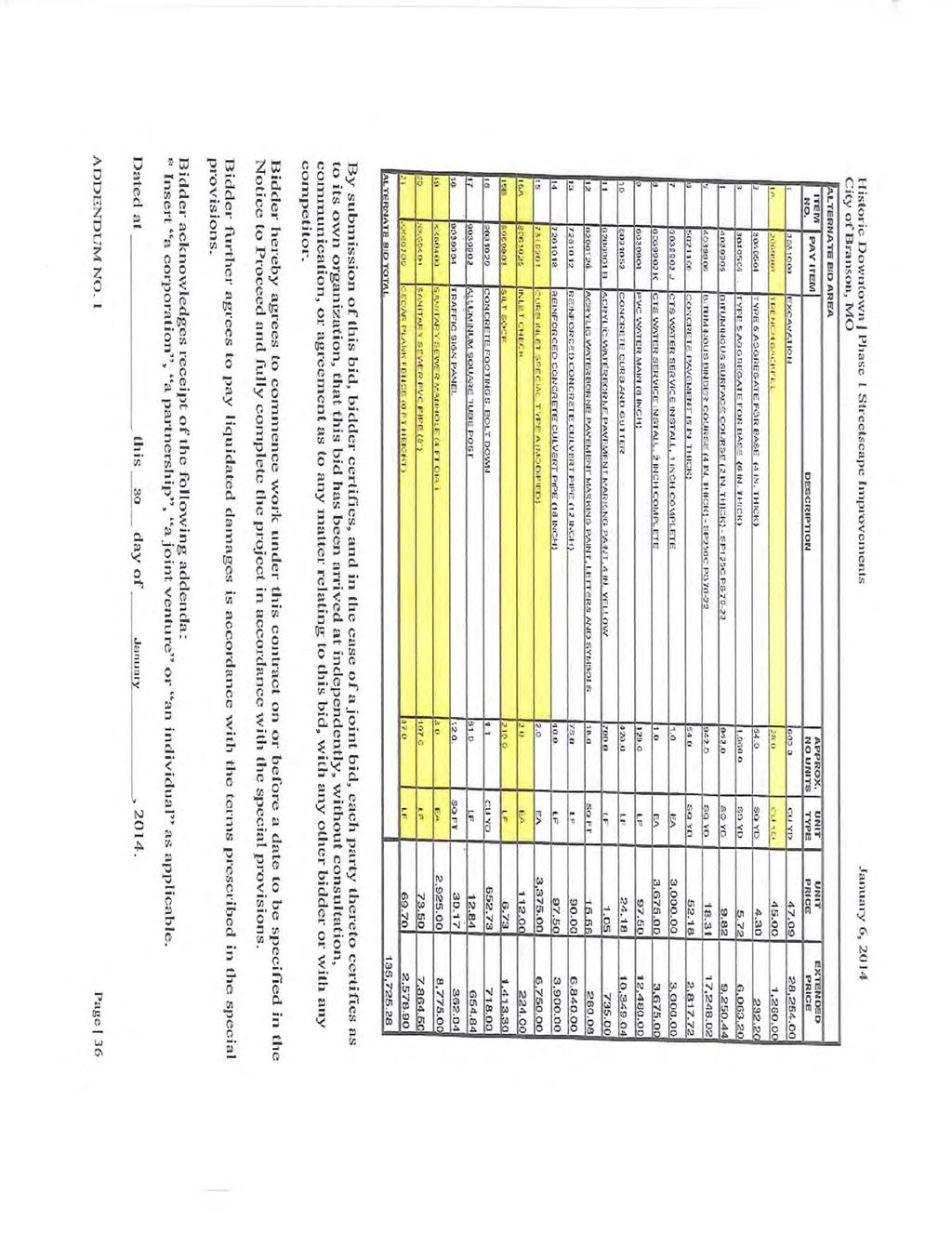
12 Capital Improvements Committee Minutes January 13, 2014 Item No. 1: In Mayor Presley s absence, Alderman Mike Booth called the meeting to order at 10:30 a.m. Item No. 2: Roll Call: Members present were City Administrator Bill Malinen, Alderman Mike Booth, and Doug Lay. Also present were City Engineer/Director Public Works David Miller, Finance Director Jamie Rouch, Assistant Finance Director Stacy McCallister, Utilities Director Mike Ray, Assistant Director of Public Works Keith Francis, and Loretta Bishop. Item No. 3: Review of Draft 20 Year Capital Improvement Plan. City Administrator Bill Malinen explained the reasoning for creation of a 20 Year Capital Improvement Plan. He stated that it is development of a process for demands and supply which might include adjusting for shortfalls and adjusting the operating budget for capital. He further stated that it might be beneficial to also create a 40 year capital plan for future improvements such as roof replacements and air conditioner replacements in city buildings. He stated that he would like the committee members to review along with staff so that we can vet and come up with a workable document that can be adopted by city council and revisit every two years. Alderman Booth stated that this is a work in progress. Some discussion ensued concerning some missing information for certain projects. Mr. Lay stated that the way it looks to him is that is based on perceived need and not perceived income. Mr. Malinen stated that the bottom line is the estimated $300 Million and the challenge will be how the city will finance the projects and using the correct revenue stream. He further stated that the needs will need to be prioritized so that we can ultimately have a sound approach to long term financing. Mr. Miller inquired if in other cities that Mr. Malinen created this document, if the need was based on department or priority. Mr. Malinen replied that some of them were based on level of service. Alderman Booth suggested highlighting the priority items and identifying the complete project including water, sewer, etc. Mr. Malinen suggested expanding the details for each line item and project. Further review will be undertaken and revisions will be made and discussion will occur at future meetings so that a complete capital improvement plan can be created. Mr. Malinen thanked staff for the diligent work and time in creating the plan. Item No. 4: Report on Construction Status. David Miller explained the spreadsheet line by line. Discussion ensued concerning bids for Downtown Gateway Improvements. David Miller stated that one bid came in at $524,000 but may have negotiated with contractor to $475,000. At this time, the consultant is recommending rejecting bids and rebid at a later date. David explained that in talking with other contractors that had picked up plans but not bid the profit margin for the project was not beneficial due to the fact that the subcontractors would be doing most of the work. David explained that he had received a phone call from a local sign contractor that stated that he did not have time to turn in a bid due to the holidays but suggested that his company could possibly construct the project under the budget parameters. There was some discussion concerning changes to the grout, aluminum to steel for lanterns, and quality of the sign structure if changes are made. Item No. 5: Change Order Update. David Miller explained that there are six change orders for review by the committee.
13 1. Change Order No. 1 Fuel Tank Replacement project in the amount of $62, approved by city council for the Tier 1 & 2 Risk Assessments due to contaminated soil. 2. Change Order No. 3 & 4 for the Fall Creek Valley WW Improvements project in the amount of $825 for additional manhole section and $11,339 for coring and installation of additional manholes. 3. Change Order No. 1 Dog Park Fence Installation project in the amount of $1,640 for removal and installation of new fencing at southeast corner of dog park. 4. Final Change Order for the Veterans Boulevard Bridge Rehabilitation project to close out the project. 5. Final Change Order for the Lift Station #9 project to close out the project. There being no further discussion, Bill Malinen made the motion to adjourn the meeting, seconded by Doug Lay. The meeting was adjourned at 11:30 a.m.
14
15
16
17
18
19
20
21

22
23
24
25
26
27
28
29
30
31
32
33
34
35
36
37
38
39
40
41
42
43
44
45
46
47
48
49
50
51
52
53
54
55
56
57
58
59
60
61
62
63
64
65
66
67
68
69
70
71

72
73

74
75

76
77
78
79
80
81
82
83
84
85
86
87
88
89
90
91
92
93
94
95
96
97
98
99
100
101
102
103
104
105
106
107
108
109
110
111
112
113
114
115
116
117
118
119
120
121
122
123
124
125
126
127
128
129
130
131
132
133
134
135
136
137
138
139
140
141
142
143
144
145
146
147
148
149 DEBORAH COHEN, CMP BIOGRAPHY Earned her bachelor s degree in Interior Design at Park University in Kansas City, Missouri. After spending a few years in the design field, she decided to pursue opportunities in the fields of sales and marketing and began her sales career at The Glen Campbell Goodtime Theater and The Grand Palace in Branson, MO. She later joined the Branson Chamber of Commerce/CVB as the Director of Tourism Development, overseeing many community-wide events and programs designed to increase tourism to the Branson/Lakes area. After a personal move took her to Memphis, Tennessee, Deborah spent five years at The Memphis Zoo where she produced special events, managed all sales efforts and handled all tourism marketing. Deborah then spent over five years at the Memphis Convention and Visitors Bureau, where she managed the international leisure group/fit markets, the incentive market and the convention market for the Western U.S. After moving back to her hometown of Branson, MO in 2010, Deborah joined the Branson Chamber of Commerce/CVB once again, but this time as Director of Meeting and Convention Sales. Deborah earned her CMP designation in September Deborah is married to Jeff Cohen and has a five year old son, Chase. MIKE COMBS BIOGRAPHY Certified Hotel Administrator and has been in the motel business for 16 years. He currently owns the La Quinta and Quality Inn & Suites and co-owns the Barrington Hotel & Suites. Mike previously served eight years on the BLACC/CVB Board of Directors and was chairman in FY and is currently on the BLACC/CVB s Finance Oversight Committee and the Membership & Funding Advisory Council. He also serves on the Branson/Lakes Area Lodging Association Board and was board president for three terms. In addition, he s on the Ozark Mountain Bank Board, the Alton Bank Board, the Fellowship of Christian Athletes Board and the Skaggs Board of Trustees. Mike is a member of the Woodland Hills Family Church.
150
151
152
153
154
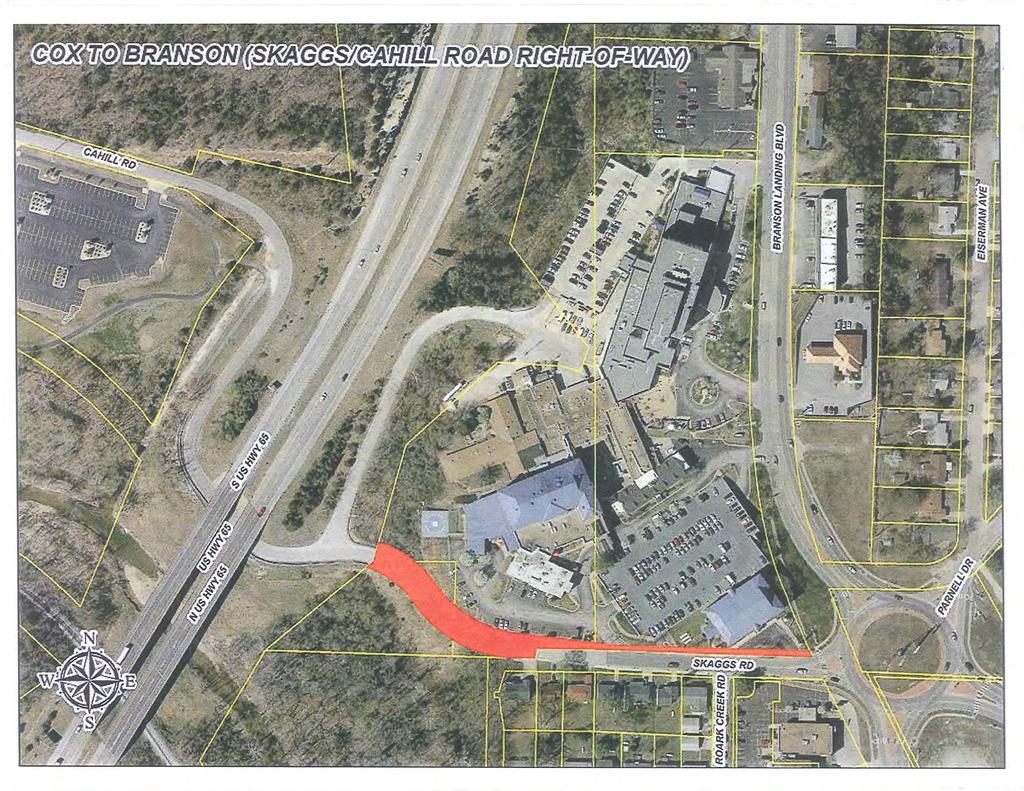
155 Exhibit 1 AGREEMENT This agreement is made and entered into by and between the City of Branson, Missouri, a Municipal Corporation, hereinafter referred to as City and Skaggs Community Hospital Association, d/b/a Cox Medical Center Branson, a Missouri Corporation, hereinafter referred to as Cox. WITNESSETH: Whereas, Cox is the owner of a hospital located within the city limits of City and with various assets located adjacent to what is generally referred to as Skaggs Road and west of what is generally referred to as Branson Landing Boulevard, and on both sides of U.S. Highway 65; and Whereas, within the real estate owned by Cox are various water and sewer lines which are operated by City, but to which City has no recorded easement; and, Whereas, Cox is the apparent owner of a portion of a roadway (Skaggs Road), located on its property which is currently used by the public and maintained by City; and Whereas, the state of Missouri, through the Missouri Highway and Transportation Commission (hereinafter MoDOT ) is the owner of portions of the land on both the east and west sides of U.S. Highway 65, with a large portion of MoDOT s excess property located on the east side of U.S. Highway 65 having potential benefits to the future use of Cox; and, Whereas, City and Cox desire to have all easements of City, to be so described and dedicated as to accurately reflect the true location of the utility or, alternatively, to relocate various utility lines to accommodate and better serve the improvements of Cox as located on its property; and, Whereas, City desires to own all of the publicly used roadway (Skaggs Road), which is partially located on Cox property, for the benefit of City and its citizens. NOW, THEREFORE, it is agreed by and between the parties as follows: Cox shall convey to City all of its interest in Skaggs Road, for the use and benefit of City and its citizens and to form a continuous roadway passing westwardly under U.S. Highway 65 and continuing west and north on the west side of U.S. Highway 65 to connect with and become Cahill Road, and eastwardly to connect with Branson Landing Boulevard all as set out and described in Paragraph 2 hereof. The parties mutually recognize and agree that the Missouri Highway And Transportation Commission (MoDOT) will not relinquish title and ownership of its excess rights of way on the east and west sides of U.S. Highway 65, as well as the roadways located therein, (known as Skaggs Road & Cahill Road) until such times as City can prove to MoDOT, by producing a recorded deed showing ownership of Skaggs Road, that it has title to all of Skaggs Road and can complete the connection thereof with the City s public road network. Therefore, a quit claim deed will need to be given, by Cox to City for that portion of Skaggs Road owned by Cox, and
156 Exhibit 1 presently used by the general public, with the mutual understanding and agreement that this consideration will precede all other exchanges of consideration contained in this Agreement and that should all other considerations flowing from one party to the other fail to come to fruition within one year after the delivery of a quit claim deed to City of the portion of Skaggs Road owned by Cox, that, at the option of Cox, the ownership of said property shall revert to Cox, and City shall, at the request of Cox, execute and deliver to Cox a quit claim deed, identical in description to the quit claim deed delivered by Cox to City described as: BEING A PART OF LOTS 1, 2 & 3 OF THE FINAL PLAT OF SKAGGS COMMUNITY HOSPITAL AND PART OF A TRACT OF LAND RECORDED IN BOOK 350 PAGE 6365 AND BOOK 239 PAGE 2154, LYING IN THE NORTHEAST QUARTER OF SECTION 32, TOWNSHIP 23 NORTH, RANGE 21 WEST, AND THE NORTHWEST QUARTER SECTION 33, TOWNSHIP 23 NORTH, RANGE 21 WEST, CITY OF BRANSON, TANEY COUNTY, MISSOURI, BEING MORE PARTICULARLY DESCRIBED AS FOLLOWS: COMMENCING AT THE SOUTHEAST CORNER OF SAID NORTHEAST QUARTER OF SECTION 32; THENCE N W, ALONG THE SOUTH LINE OF SAID NORTHEAST QUARTER, FEET FOR A POINT OF BEGINNING. THENCE CONTINUING N W, ALONG SAID SOUTH LINE, FEET; THENCE LEAVING SAID SOUTH LINE, NORTHWESTERLY THROUGH A CURVE TO THE RIGHT, HAVING A CENTRAL ANGLE OF , A RADIUS OF FEET, AN ARC LENGTH OF FEET, AND A CHORD BEARING AND DISTANCE OF N W, FEET; THENCE N W, FEET; THENCE NORTHWESTERLY, THROUGH A CURVE TO THE LEFT, HAVING A CENTRAL ANGLE OF , A RADIUS OF FEET, AN ARC LENGTH OF FEET, AND A CHORD BEARING AND DISTANCE OF N W, FEET; THENCE N W, FEET; THENCE NORTHWESTERLY THROUGH A CURVE TO THE LEFT, HAVING A CENTRAL ANGLE OF , A RADIUS OF FEET AN ARC LENGTH OF FEET, AND A CHORD BEARING AND DISTANCE OF N W, FEET TO A POINT ON THE EASTERLY RIGHT-OF- WAY LINE OF U.S. HIGHWAY 65; THENCE N E, ALONG SAID EASTERLY RIGHT-OF-WAY LINE, FEET TO STATION , FEET LEFT; THENCE N E, ALONG EASTERLY RIGHT- OF-WAY LINE, FEET; THENCE S E, LEAVING SAID EASTERLY RIGHT-OF-WAY LINE, FEET; THENCE SOUTHEASTERLY THROUGH A CURVE TO THE RIGHT, HAVING A CENTRAL ANGLE OF , A RADIUS OF FEET, AN ARC LENGTH OF FEET, AND A CHORD BEARING AND DISTANCE OF S E, FEET; THENCE S E, FEET; THENCE SOUTHEASTERLY THROUGH A CURVE TO THE LEFT, HAVING A CENTRAL ANGLE OF , A RADIUS OF FEET, AN ARC LENGTH OF FEET, AND A CHORD BEARING AND DISTANCE OF S E, FEET; THENCE S E, FEET; THENCE 1
157 Exhibit 1 S E, FEET; THENCE N E, 6.52 FEET TO A POINT ON THE WESTERLY RIGHT-OF-WAY LINE OF BRANSON LANDING BOULEVARD; THENCE SOUTHEASTERLY ALONG SAID WESTERLY RIGHT-OF-WAY LINE, THROUGH A NON-TANGENT CURVE TO THE LEFT, HAVING A CENTRAL ANGLE OF , A RADIUS OF FEET, AN ARC LENGTH OF FEET, AND A CHORD BEARING AND DISTANCE OF S E, FEET TO THE NORTH RIGHT-OF-WAY LINE OF SKAGGS ROAD; THENCE N W, ALONG SAID NORTH RIGHT-OF-WAY LINE, FEET; THENCE S W, FEET TO THE POINT OF BEGINNING. CONTAINING 24, SQUARE FEET OR 0.56 ACRES, MORE OR LESS. 1. Cox shall convey to City accurate easements for the present locations of all existing water and sewer lines on Cox s property and any water or sewer lines to be relocated at the sole expense of Cox all of which are legally described as follows: A 15 FOOT WIDE UTILITY EASEMENT BEING A PART OF A TRACT OF LAND LYING IN THE NORTHEAST QUARTER OF SECTION 32, TOWNSHIP 23 NORTH, RANGE 21 WEST, CITY OF BRANSON, TANEY COUNTY, MISSOURI, LYING 7.5 FEET EITHER SIDE OF THE FOLLOWING DESCRIBED CENTERLINE: I. A UTILITY EASEMENT BEING A PART OF A TRACT OF LAND LYING IN THE NORTHEAST QUARTER OF SECTION 32, TOWNSHIP 23 NORTH, RANGE 21 WEST, CITY OF BRANSON, TANEY COUNTY, MISSOURI, BEING DESCRIBED AS FOLLOWS: COMMENCING AT THE SOUTHEAST CORNER OF SAID NORTHEAST QUARTER; THENCE N W, ALONG THE SOUTH LINE OF SAID NORTHEAST QUARTER, FEET; THENCE N E, LEAVING SAID SOUTH LINE, FEET; THENCE N E, FEET; THENCE N E, FEET; THENCE N E, FEET; THENCE N E, FEET FOR A POINT OF BEGINNING (B). THENCE N E, FEET; THENCE S E, FEET; THENCE S W, FEET TO THE POINT OF BEGINNING (B); ALL CONTAINING 11, SQUARE FEET OR 0.26 ACRES MORE OR LESS. ALSO, II. COMMENCING AT THE SOUTHEAST CORNER OF SAID NORTHEAST QUARTER OF SECTION 32; THENCE N W, ALONG 2
158 Exhibit 1 THE SOUTH LINE OF SAID NORTHEAST QUARTER, FEET; THENCE N E, LEAVING SAID SOUTH LINE, FEET FOR A POINT OF BEGINNING (A). THENCE N E, FEET; THENCE S E, FEET; THENCE N W, FEET; THENCE N E, FEET; THENCE S W, FEET; THENCE S E, FEET; THENCE N W, FEET TO THE POINT OF BEGINNING (A); ALSO, III. COMMENCING AT THE SOUTHEAST CORNER OF SAID NORTHEAST QUARTER OF SECTION 32; THENCE N W, ALONG THE SOUTH LINE OF SAID NORTHEAST QUARTER, FEET; THENCE N E, LEAVING SAID SOUTH LINE, FEET; THENCE N E, FEET; THENCE N E, FEET; THENCE N E, FEET FOR A POINT OF BEGINNING (B). THENCE N E, FEET; THENCE N E, FEET; THENCE S E, FEET; THENCE S W, FEET; THENCE N W, FEET TO THE POINT OF BEGINNING (B); ALSO, IV. A 15 FOOT WIDE SANITARY SEWER EASEMENT BEING 7.5 FEET EITHER SIDE OF THE FOLLOWING DESCRIBED CENTERLINE: COMMENCING AT THE SOUTHEAST CORNER OF SAID NORTHEAST QUARTER OF SECTION 32; THENCE S E, ALONG THE SOUTH LINE OF SAID NORTHWEST QUARTER, FEET; THENCE N E, LEAVING SAID SOUTH LINE, FEET TO A POINT ON THE PROPOSED NORTH RIGHT-OF-WAY LINE OF SKAGGS ROAD FOR A POINT OF BEGINNING (C). THENCE N E, LEAVING SAID NORTH RIGHT-OF-WAY LINE, 4.58 FEET; THENCE N W, FEET FOR A POINT OF TERMINUS (C); ALSO, V. A 15 FOOT WIDE SANITARY SEWER EASEMENT BEING 7.5 FEET EITHER SIDE OF THE FOLLOWING DESCRIBED CENTERLINE: COMMENCING AT THE SOUTHEAST CORNER OF SAID NORTHEAST QUARTER OF SECTION 32; THENCE S E, ALONG THE SOUTH LINE OF SAID NORTHWEST QUARTER, FEET; THENCE N E, LEAVING SAID SOUTH LINE, FEET TO A POINT ON THE WEST RIGHT-OF-WAY LINE OF BRANSON LANDING BOULEVARD; THENCE NORTHWESTERLY ALONG SAID WEST RIGHT- OF-WAY LINE, THROUGH A NON-TANGENT CURVE TO THE RIGHT, 3
159 Exhibit 1 HAVING A CENTRAL ANGLE OF , A RADIUS OF FEET, AN ARC LENGTH OF FEET, AND A CHORD BEARING AND DISTANCE OF N W, FEET FOR A POINT OF BEGINNING (D); THENCE S W, LEAVING SAID WEST RIGHT-OF-WAY LINE, 4.47 FEET; THENCE N W, FEET; THENCE N W, FEET FOR A POINT OF TERMINUS (D); ALSO, VI. COMMENCING AT THE SOUTHEAST CORNER OF SAID NORTHEAST QUARTER OF SECTION 32; THENCE S E, ALONG THE SOUTH LINE OF SAID NORTHEAST QUARTER, FEET; THENCE N E, LEAVING SAID SOUTH LINE, FEET FOR A POINT OF BEGINNING (A); THENCE S W, FEET; THENCE SOUTHWESTERLY THROUGH A CURVE TO THE RIGHT, HAVING A CENTRAL ANGLE OF , A RADIUS OF FEET, AN ARC LENGTH OF FEET, AND A CHORD BEARING AND DISTANCE OF S W, FEET; THENCE N W, FEET; THENCE N W, FEET; THENCE N W, FEET; THENCE N E, FEET; THENCE N E, FEET; THENCE N W, FEET; THENCE N E, FEET; THENCE N E, FEET; THENCE N E, FEET; THENCE N E, FEET; THENCE N E, FEET; THENCE N E, FEET FOR A POINT OF TERMINUS (A); ALSO, VII. COMMENCING AT THE SOUTHEAST CORNER OF SAID NORTHEAST QUARTER OF SECTION 32; THENCE N W, ALONG THE SOUTH LINE OF SAID NORTHEAST QUARTER, FEET; THENCE N E, LEAVING SAID SOUTH LINE, FEET TO A POINT ON THE PROPOSED NORTH RIGHT-OF-WAY LINE OF SKAGGS ROAD FOR A POINT OF BEGINNING (B). THENCE N E, FEET FOR A POINT OF TERMINUS (B); ALSO, VIII. COMMENCING AT THE SOUTHEAST CORNER OF SAID NORTHEAST QUARTER OF SECTION 32; THENCE S E, ALONG THE SOUTH LINE OF SAID NORTHWEST QUARTER, FEET; THENCE N E, LEAVING SAID SOUTH LINE, FEET TO A POINT ON THE PROPOSED NORTH RIGHT-OF-WAY LINE OF SKAGGS ROAD FOR A POINT OF BEGINNING (C). THENCE N W, FEET; THENCE N W, FEET; THENCE N W, FEET; THENCE N W, FEET; THENCE N W, FEET FOR A POINT OF TERMINUS (C); 4
160 Exhibit 1 ALSO, IX. COMMENCING AT THE SOUTHEAST CORNER OF SAID NORTHEAST QUARTER OF SECTION 32; THENCE S E, ALONG THE SOUTH LINE OF SAID NORTHEAST QUARTER, FEET; THENCE N E, LEAVING SAID SOUTH LINE, FEET; THENCE S W, FEET; THENCE SOUTHWESTERLY THROUGH A CURVE TO THE RIGHT, HAVING A CENTRAL ANGLE OF , A RADIUS OF FEET, AN ARC LENGTH OF FEET, AND A CHORD BEARING AND DISTANCE OF S W, FEET; THENCE N W, FEET; THENCE N W, FEET; THENCE N W, FEET; THENCE N E, FEET; THENCE N E, FEET; THENCE N W, FEET; THENCE N E, FEET; THENCE N E, FEET; THENCE N E, FEET; THENCE N E, FEET; THENCE N E, FEET; THENCE N E, FEET; THENCE N E, FEET FOR A POINT OF BEGINNING (D); THENCE S E, FEET; THENCE N E, FEET; THENCE N W, FEET; THENCE S W, FEET FOR A POINT OF TERMINUS (D); ALSO, X. COMMENCING AT THE SOUTHEAST CORNER OF SAID NORTHEAST QUARTER OF SECTION 32; THENCE S E, ALONG THE SOUTH LINE OF SAID NORTHWEST QUARTER, FEET; THENCE N E, LEAVING SAID SOUTH LINE, FEET TO A POINT ON THE WEST RIGHT-OF-WAY LINE OF BRANSON LANDING BOULEVARD; THENCE NORTHWESTERLY ALONG SAID WEST RIGHT- OF-WAY LINE, THROUGH A NON-TANGENT CURVE TO THE RIGHT, HAVING A CENTRAL ANGLE OF , A RADIUS OF FEET, AN ARC LENGTH OF FEET, AND A CHORD BEARING AND DISTANCE OF N W, FEET FOR A POINT OF BEGINNING (E). THENCE S W, FEET; THENCE N W, FEET; THENCE N W, FEET; THENCE N W, FEET; THENCE S W, FEET; THENCE N W, FEET; THENCE N W, FEET; THENCE N W, FEET; THENCE N W, FEET; THENCE N E, FEET TO A POINT ON SAID WEST RIGHT-OF-WAY LINE OF BRANSON LANDING BOULEVARD FOR A POINT OF TERMINUS (E); ALSO, XI. COMMENCING AT THE SOUTHEAST CORNER OF SAID NORTHEAST QUARTER OF SECTION 32; THENCE S E, ALONG 5
161 Exhibit 1 THE SOUTH LINE OF SAID NORTHWEST QUARTER, FEET; THENCE N E, LEAVING SAID SOUTH LINE, FEET FOR A POINT OF BEGINNING (F). THENCE S W, FEET; THENCE S W, FEET; THENCE N W, FEET FOR A POINT OF TERMINUS (F); ALSO, XII. COMMENCING AT THE SOUTHEAST CORNER OF SAID NORTHEAST QUARTER OF SECTION 32; THENCE S E, ALONG THE SOUTH LINE OF SAID NORTHWEST QUARTER, FEET; THENCE N E, LEAVING SAID SOUTH LINE, FEET FOR A POINT OF BEGINNING (G). THENCE N E, FEET FOR A POINT OF TERMINUS (G); ALSO, XIII. COMMENCING AT THE SOUTHEAST CORNER OF SAID NORTHEAST QUARTER OF SECTION 32; THENCE S E, ALONG THE SOUTH LINE OF SAID NORTHWEST QUARTER, FEET; THENCE N E, LEAVING SAID SOUTH LINE, FEET FOR A POINT OF BEGINNING (H). THENCE N E, FEET FOR A POINT OF TERMINUS (H); ALSO, XIV. COMMENCING AT THE SOUTHEAST CORNER OF SAID NORTHEAST QUARTER OF SECTION 32; THENCE S E, ALONG THE SOUTH LINE OF SAID NORTHWEST QUARTER, FEET; THENCE N E, LEAVING SAID SOUTH LINE, FEET TO A POINT ON THE PROPOSED NORTH RIGHT-OF-WAY LINE OF SKAGGS ROAD FOR A POINT OF BEGINNING (I). THENCE N E, 6.45 FEET; THENCE N E, FEET TO A POINT ON THE WEST RIGHT-OF-WAY LINE OF BRANSON LANDING BOULEVARD FOR A POINT OF TERMINUS (I). 2. As further consideration for this agreement, City shall convey to Cox all property acquired from MoDOT lying on the east side of U.S. Highway 65 and hereinafter legally described in Paragraph 5: 3. Less and except that portion thereof, upon which Skaggs Road shall be continued in its present location, east and west, through said above described property and legally described as : BEING A PART OF A TRACT OF LAND LYING IN THE NORTHEAST QUARTER OF SECTION 32, TOWNSHIP 23 NORTH, RANGE 21 WEST, 6
162 Exhibit 1 CITY OF BRANSON, TANEY COUNTY, MISSOURI, BEING DESCRIBED AS FOLLOWS: COMMENCING AT THE SOUTHEAST CORNER OF SAID NORTHEAST QUARTER; THENCE N W, ALONG THE SOUTH LINE OF SAID NORTHEAST QUARTER, FEET; THENCE N E, LEAVING SAID SOUTH LINE, FEET FOR A POINT OF BEGINNING. THENCE NORTHWESTERLY THROUGH A NON-TANGENT CURVE TO THE LEFT, HAVING A CENTRAL ANGLE OF , A RADIUS OF FEET, AN ARC LENGTH OF FEET, AND A CHORD BEARING AND DISTANCE OF N W, FEET; THENCE S W, FEET; THENCE N E, FEET; THENCE N E, FEET; THENCE THROUGH A CURVE TO THE RIGHT, HAVING A CENTRAL ANGLE OF , A RADIUS OF FEET, AND A CHORD BEARING AND DISTANCE OF S E, FEET; THENCE S W, FEET; THENCE S W, FEET TO THE POINT OF BEGINNING. ALSO EXCEPTING, I. A 15 FOOT WIDE UTILITY EASEMENT BEING A PART OF A TRACT OF LAND LYING IN THE NORTHEAST QUARTER OF SECTION 32, TOWNSHIP 23 NORTH, RANGE 21 WEST, CITY OF BRANSON, TANEY COUNTY, MISSOURI, LYING 7.5 FEET EITHER SIDE OF THE FOLLOWING DESCRIBED CENTERLINE: COMMENCING AT THE SOUTHEAST CORNER OF SAID NORTHEAST QUARTER; THENCE N W, ALONG THE SOUTH LINE OF SAID NORTHEAST QUARTER, FEET; THENCE N E, LEAVING SAID SOUTH LINE, FEET FOR A POINT OF BEGINNING (A). THENCE N E, FEET; THENCE N E, FEET; THENCE NORTHEASTERLY THROUGH A CURVE TO THE RIGHT, HAVING A CENTRAL ANGLE OF , A RADIUS OF FEET, AN ARC LENGTH OF FEET, AND A CHORD BEARING AND DISTANCE OF N E, FEET; THENCE S E, FEET; THENCE N E, FEET FOR A POINT OF TERMINUS. SIDE LINES OF THE ABOVE UTILITY EASEMENT ARE TO BE LENGTHENED OR SHORTENED TO TERMINATE ON PROPERTY LINES, RIGHT OF WAY LINES OR EXISTING EASEMENT LINES, AS APPLICABLE. ALSO EXCEPTING, 7
163 Exhibit 1 II. A SANITARY SEWER EASEMENT COMMENCING AT THE SOUTHEAST CORNER OF SAID NORTHEAST QUARTER OF SECTION 32; THENCE N W, ALONG THE SOUTH LINE OF SAID NORTHEAST QUARTER, FEET; THENCE N E, LEAVING SAID SOUTH LINE, FEET FOR A POINT OF BEGINNING (A). THENCE N W, 3.06 FEET; THENCE NORTHWESTERLY THROUGH A NON-TANGENT CURVE TO THE RIGHT, HAVING A CENTRAL ANGLE OF , A RADIUS OF FEET, AN ARC LENGTH OF FEET, AND A CHORD BEARING AND DISTANCE OF N W, FEET; THENCE S W, FEET; THENCE N E, FEET; THENCE S E, FEET; THENCE S W, FEET TO THE POINT OF BEGINNING (A). ALSO EXCEPTING, III. A SANITARY SEWER EASEMENT COMMENCING AT THE SOUTHEAST CORNER OF SAID NORTHEAST QUARTER OF SECTION 32; THENCE N W, ALONG THE SOUTH LINE OF SAID NORTHEAST QUARTER, FEET; THENCE N E, LEAVING SAID SOUTH LINE, FEET FOR A POINT OF BEGINNING (B). THENCE N W, FEET; THENCE N E, FEET; THENCE N E, FEET; THENCE N E, FEET; THENCE N E, FEET; THENCE N E, FEET; THENCE S E, FEET; THENCE S E, FEET; THENCE S E, FEET; THENCE S W, FEET; THENCE S W, FEET; THENCE N W, FEET; THENCE N W, FEET; THENCE S W, FEET; THENCE S W, FEET; THENCE S E, FEET; THENCE S W, FEET; THENCE S W, FEET; THENCE S W, FEET; THENCE S W, FEET TO THE POINT OF BEGINNING (B). ALL CONTAINING 10, SQUARE FEET OR 0.23 ACRES MORE OR LESS. 4. It is specifically understood and agreed that all agreements and covenants contained herein are subject to : The initial conveyance by MODOT of excess right-of-way on the east and west sides of U.S. Highway 65, described as : Tract on east side of highway: 8
164 Exhibit 1 A TRACT OF LAND BEING A PART OF THE NORTHEAST QUARTER OF SECTION 32, TOWNSHIP 23 NORTH, RANGE 21 WEST, IN THE CITY OF BRANSON, TANEY COUNTY, MISSOURI BEING MORE PARTICULARLY DESCRIBED AS FOLLOWS: COMMENCING AT AN EXISTING 1/2" IRON PIN MARKING THE SOUTHEAST CORNER OF THE SOUTHEAST QUARTER OF THE NORTHEAST QUARTER OF SAID SECTION 32; THENCE N88 43'58"W, ALONG THE SOUTH LINE OF SAID SOUTHEAST QUARTER OF THE NORTHEAST QUARTER, FEET TO A POINT ON THE EASTERLY RIGHT-OF-WAY LINE AS IT NOW EXISTS OF U.S. HIGHWAY 65; THENCE N32 08'41"E, ALONG SAID EASTERLY RIGHT-OF-WAY LINE, FEET FOR A POINT OF BEGINNING "A". THENCE N20 33'12"W, LEAVING SAID EASTERLY RIGHT-OF-WAY LINE, 3.86 FEET TO A POINT FEET LEFT OF SAID U.S. HIGHWAY 65 CENTERLINE STATION ; THENCE N18 44'28"E, FEET TO A POINT FEET LEFT OF SAID U.S. HIGHWAY 65 CENTERLINE STATION ; THENCE N24 52'16"E, FEET TO A POINT FEET LEFT OF SAID U.S. HIGHWAY 65 CENTERLINE STATION ; THENCE N39 32'47"E, FEET TO A POINT FEET LEFT OF SAID U.S. HIGHWAY 65 CENTERLINE STATION SAID POINT BEING ON SAID EASTERLY RIGHT-OF-WAY LINE OF U.S. HIGHWAY 65 AS IT NOW EXISTS; THENCE ALONG SAID EASTERLY RIGHT-OF-WAY LINE THE FOLLOWING SIX COURSES: S35 13'16"E, FEET TO A POINT FEET LEFT OF SAID U.S. HIGHWAY 65 CENTERLINE STATION ; S21 26'04"W, FEET TO A POINT FEET LEFT OF SAID U.S. HIGHWAY 65 CENTERLINE STATION ; S88 56'49"W, FEET TO A POINT FEET LEFT OF SAID U.S. HIGHWAY 65 CENTERLINE STATION ; S46 14'43"W, FEET TO A POINT FEET LEFT OF SAID U.S. HIGHWAY 65 CENTERLINE STATION ; S21 20'12"W, FEET TO A POINT FEET LEFT OF SAID U.S. HIGHWAY 65 CENTERLINE STATION ; S46 55'41"W, FEET TO THE POINT OF BEGINNING "A". CONTAINING 2.66 ACRES. SUBJECT TO ALL EASEMENTS AND RESTRICTIONS OF RECORD. Tract on west side of highway: A TRACT OF LAND BEING A PART OF THE NORTHEAST QUARTER OF SECTION 32, TOWNSHIP 23 NORTH, RANGE 21 WEST, IN THE CITY OF BRANSON, TANEY COUNTY, MISSOURI BEING MORE PARTICULARLY DESCRIBED AS FOLLOWS: COMMENCING AT AN EXISTING 1/2" IRON PIN MARKING THE SOUTHEAST CORNER OF THE SOUTHEAST QUARTER OF THE 9
165 Exhibit 1 NORTHEAST QUARTER OF SAID SECTION 32; THENCE N88 43'58"W, ALONG THE SOUTH LINE OF SAID SOUTHEAST QUARTER OF THE NORTHEAST QUARTER, FEET TO A POINT ON THE WESTERLY RIGHT-OF-WAY LINE AS IT NOW EXISTS OF U.S. HIGHWAY 65; THENCE N31 19'21"E, ALONG SAID WESTERLY RIGHT-OF-WAY LINE, FEET TO A POINT FEET RIGHT OF SAID U.S. HIGHWAY 65 CENTERLINE STATION FOR A POINT OF BEGINNING "B". THENCE ALONG SAID WESTERLY RIGHT-OF-WAY LINE THE FOLLOWING SIX COURSES: N00 35'34"W, FEET TO A POINT FEET RIGHT OF SAID U.S. HIGHWAY 65 CENTERLINE STATION ; N31 42'28"E, FEET TO A POINT FEET RIGHT OF SAID U.S. HIGHWAY 65 CENTERLINE STATION ; N33 46'11"E, FEET TO A POINT FEET RIGHT OF SAID U.S. HIGHWAY 65 CENTERLINE STATION ; N51 47'06"W, FEET TO A POINT FEET RIGHT OF SAID U.S. HIGHWAY 65 CENTERLINE STATION ; N16 37'35"E, FEET TO A POINT FEET RIGHT OF SAID U.S. HIGHWAY 65 CENTERLINE STATION ; S82 16'17"E, FEET TO A POINT FEET RIGHT OF SAID U.S. HIGHWAY 65 CENTERLINE STATION ; THENCE S13 53'21"W, LEAVING SAID WESTERLY RIGHT-OF-WAY LINE, FEET TO A POINT FEET RIGHT OF SAID U.S. HIGHWAY 65 CENTERLINE STATION ; THENCE S32 27'33"W, FEET TO THE POINT OF BEGINNING "B". CONTAINING 2.42 ACRES. SUBJECT TO ALL EASEMENTS AND RESTRICTIONS OF RECORD. a. All utility locations and relocations on property owned by Cox being performed and completed at the sole cost and expense of Cox and with minimal disruption of such services to other citizens and customers of City as is reasonably possible, and under no circumstances, for a period greater than 12 hours. In addition, all of said relocated sewer lines and water lines shall be installed pursuant to the City s regulations and specifications and inspected by City as its ordinances and regulations may apply and require. b. The completion of all engineering and survey work required by MoDOT in its Missouri Highway and Transportation Commission Road Relinquishment Agreement, attached hereto, marked Exhibit 3 and incorporated herein referenced, which shall be the sole responsibility of Cox, with the exception of future maintenance requirements on the roads which are to become the exclusive property of City, for public use. 5. Each of the parties agree to execute any and all documents that may be required of either party, in the future, to carry out the intent of this particular Agreement and which are not contrary to or violate any of the terms of this Agreement nor are detrimental to either party or to any stated purpose set forth herein. 10
166 Exhibit 1 This agreement shall be binding upon any inure to the benefit of the respective parties hereto, their successors and assigns and shall be governed solely by the laws of the State of Missouri. IN WITNESS WHEREOF, the City of Branson has caused this Agreement to be executed by its Mayor, Reanne Presley, and attested by its City Clerk Lisa K Westfall, after passage and approval of same by the Board of Aldermen of the City of Branson, Missouri, executed by Skaggs Community Hospital Association, d/b/a/ Cox Medical Center Branson, by its president, all with the direction and authority granted to him by the Board of Directors of Skaggs Community Hospital Association, at a meeting, duly and properly called at which at a quorum was present and wherein a majority of the members of said Board authorized the execution of this agreement by said corporate officer. City of Branson Attest: Lisa K Westfall, City Clerk By: Raeanne Presley, Mayor Skaggs Community Hospital Association, d/b/a Cox Medical Center Branson By: William Mahoney, President 11
167
168
169
170
171
172
173

174
175 Exhibit C QUIT CLAIM DEED THIS INDENTURE is made this day of, 2014, by and between The City of Branson, Missouri, of the County of Taney, State of Missouri, Grantor, and Skaggs Community Hospital Association d/b/a Cox Medical Center Branson, A Missouri Corporation, of the County of Taney, State of Missouri, Grantee. Grantee s mailing address is. WITNESSETH, that the said Grantor, for and in consideration of the sum of and other good and valuable consideration, (the receipt of which is hereby acknowledged), does by these presents REMISE, RELEASE AND FOREVER QUIT CLAIM unto the said Grantee, the following described lots, tracts, or parcels of land, lying, being and situate in the County of Taney, State of Missouri, to-wit: Tract on east side of highway: A TRACT OF LAND BEING A PART OF THE NORTHEAST QUARTER OF SECTION 32, TOWNSHIP 23 NORTH, RANGE 21 WEST, IN THE CITY OF BRANSON, TANEY COUNTY, MISSOURI BEING MORE PARTICULARLY DESCRIBED AS FOLLOWS: COMMENCING AT AN EXISTING 1/2" IRON PIN MARKING THE SOUTHEAST CORNER OF THE SOUTHEAST QUARTER OF THE NORTHEAST QUARTER OF SAID SECTION 32; THENCE N88 43'58"W, ALONG THE SOUTH LINE OF SAID SOUTHEAST QUARTER OF THE NORTHEAST QUARTER, FEET TO A POINT ON THE EASTERLY RIGHT-OF-WAY LINE AS IT NOW EXISTS OF U.S. HIGHWAY 65; THENCE N32 08'41"E, ALONG SAID EASTERLY RIGHT-OF-WAY LINE, FEET FOR A POINT OF BEGINNING "A". THENCE N20 33'12"W, LEAVING SAID EASTERLY RIGHT-OF-WAY LINE, 3.86 FEET TO A POINT FEET LEFT OF SAID U.S. HIGHWAY 65 CENTERLINE STATION ; THENCE N18 44'28"E, FEET TO A POINT FEET LEFT OF SAID U.S. HIGHWAY 65 CENTERLINE STATION ; THENCE N24 52'16"E, FEET TO A POINT FEET LEFT OF SAID U.S. HIGHWAY 65 CENTERLINE STATION ; 1
176 THENCE N39 32'47"E, FEET TO A POINT FEET LEFT OF SAID U.S. HIGHWAY 65 CENTERLINE STATION SAID POINT BEING ON SAID EASTERLY RIGHT-OF-WAY LINE OF U.S. HIGHWAY 65 AS IT NOW EXISTS; THENCE ALONG SAID EASTERLY RIGHT-OF-WAY LINE THE FOLLOWING SIX COURSES: S35 13'16"E, FEET TO A POINT FEET LEFT OF SAID U.S. HIGHWAY 65 CENTERLINE STATION ; S21 26'04"W, FEET TO A POINT FEET LEFT OF SAID U.S. HIGHWAY 65 CENTERLINE STATION ; S88 56'49"W, FEET TO A POINT FEET LEFT OF SAID U.S. HIGHWAY 65 CENTERLINE STATION ; S46 14'43"W, FEET TO A POINT FEET LEFT OF SAID U.S. HIGHWAY 65 CENTERLINE STATION ; S21 20'12"W, FEET TO A POINT FEET LEFT OF SAID U.S. HIGHWAY 65 CENTERLINE STATION ; S46 55'41"W, FEET TO THE POINT OF BEGINNING "A"; CONTAINING 2.66 ACRES. SUBJECT TO ALL EASEMENTS AND RESTRICTIONS OF RECORD; LESS AND EXCEPT: BEING A PART OF A TRACT OF LAND LYING IN THE NORTHEAST QUARTER OF SECTION 32, TOWNSHIP 23 NORTH, RANGE 21 WEST, CITY OF BRANSON, TANEY COUNTY, MISSOURI, BEING DESCRIBED AS FOLLOWS: COMMENCING AT THE SOUTHEAST CORNER OF SAID NORTHEAST QUARTER; THENCE N W, ALONG THE SOUTH LINE OF SAID NORTHEAST QUARTER, FEET; THENCE N E, LEAVING SAID SOUTH LINE, FEET FOR A POINT OF BEGINNING. THENCE NORTHWESTERLY THROUGH A NON-TANGENT CURVE TO THE LEFT, HAVING A CENTRAL ANGLE OF , A RADIUS OF FEET, AN ARC LENGTH OF FEET, AND A CHORD BEARING AND DISTANCE OF N W, FEET; THENCE S W, FEET; THENCE N E, FEET; THENCE N E, FEET; THENCE THROUGH A CURVE TO THE RIGHT, HAVING A CENTRAL ANGLE OF , A RADIUS OF FEET, AND A CHORD BEARING AND DISTANCE OF S E, FEET; THENCE S W, FEET; THENCE S W, FEET TO THE POINT OF BEGINNING; Grantee, by acceptance of this conveyance, covenants and agrees for itself, its successors and assigns, to allow known or unknown utility facilities currently located on the property, whether of record or not, to remain on the property, and to grant to current subsequent owners of those facilities the right to maintain, construct and reconstruct the facilities and their appurtenances over, under, and across the land herein conveyed, along with the right of ingress 2
177 and egress across the land herein conveyed to and from those utilities, including, but not limited to, the following known easements: A 15 FOOT WIDE UTILITY EASEMENT BEING A PART OF A TRACT OF LAND LYING IN THE NORTHEAST QUARTER OF SECTION 32, TOWNSHIP 23 NORTH, RANGE 21 WEST, CITY OF BRANSON, TANEY COUNTY, MISSOURI, LYING 7.5 FEET EITHER SIDE OF THE FOLLOWING DESCRIBED CENTERLINE: COMMENCING AT THE SOUTHEAST CORNER OF SAID NORTHEAST QUARTER; THENCE N W, ALONG THE SOUTH LINE OF SAID NORTHEAST QUARTER, FEET; THENCE N E, LEAVING SAID SOUTH LINE, FEET FOR A POINT OF BEGINNING (A). THENCE N E, FEET; THENCE N E, FEET; THENCE NORTHEASTERLY THROUGH A CURVE TO THE RIGHT, HAVING A CENTRAL ANGLE OF , A RADIUS OF FEET, AN ARC LENGTH OF FEET, AND A CHORD BEARING AND DISTANCE OF N E, FEET; THENCE S E, FEET; THENCE N E, FEET FOR A POINT OF TERMINUS. SIDE LINES OF THE ABOVE UTILITY EASEMENT ARE TO BE LENGTHENED OR SHORTENED TO TERMINATE ON PROPERTY LINES, RIGHT OF WAY LINES OR EXISTING EASEMENT LINES, AS APPLICABLE. ALSO, A SANITARY SEWER EASEMENT COMMENCING AT THE SOUTHEAST CORNER OF SAID NORTHEAST QUARTER OF SECTION 32; THENCE N W, ALONG THE SOUTH LINE OF SAID NORTHEAST QUARTER, FEET; THENCE N E, LEAVING SAID SOUTH LINE, FEET FOR A POINT OF BEGINNING (A). THENCE N W, 3.06 FEET; THENCE NORTHWESTERLY THROUGH A NON-TANGENT CURVE TO THE RIGHT, HAVING A CENTRAL ANGLE OF , A RADIUS OF FEET, AN ARC LENGTH OF FEET, AND A CHORD BEARING AND DISTANCE OF N W, FEET; THENCE S W, FEET; THENCE N E, FEET; THENCE S E, FEET; THENCE S W, FEET TO THE POINT OF BEGINNING (A). ALSO, A SANITARY SEWER EASEMENT COMMENCING AT THE SOUTHEAST CORNER OF SAID NORTHEAST QUARTER OF SECTION 32; THENCE N W, ALONG THE SOUTH LINE OF SAID NORTHEAST QUARTER, FEET; THENCE N E, LEAVING SAID SOUTH LINE, FEET FOR A POINT OF BEGINNING (B). THENCE 3
178 N W, FEET; THENCE N E, FEET; THENCE N E, FEET; THENCE N E, FEET; THENCE N E, FEET; THENCE N E, FEET; THENCE S E, FEET; THENCE S E, FEET; THENCE S E, FEET; THENCE S W, FEET; THENCE S W, FEET; THENCE N W, FEET; THENCE N W, FEET; THENCE S W, FEET; THENCE S W, FEET; THENCE S E, FEET; THENCE S W, FEET; THENCE S W, FEET; THENCE S W, FEET; THENCE S W, FEET TO THE POINT OF BEGINNING (B). ALL CONTAINING 10, SQUARE FEET OR 0.23 ACRES MORE OR LESS. TO HAVE AND TO HOLD THE SAME, with all the rights, immunities, privileges and appurtenances thereto belonging unto the said Grantee, its successors and assigns forever; so that neither the said Grantor nor its successors or assigns nor any other person or entity, for it or in its name or behalf, shall or will hereafter claim or demand any right or title to the aforesaid premises, or any part thereof. IN WITNESS WHEREOF, the said Grantor has caused this deed to be executed by its authorized officer the day and year first above written. City of Branson By: Raeanne Presley, Mayor Attest: Approved as to Form: Lisa K Westfall, City Clerk William T. Duston, City Attorney 4
179 STATE OF MISSOURI ) ) ss. COUNTY OF TANEY ) On this day of, 2014, before me, personally appeared Reanne Presley, Mayor of The City of Branson, Missouri, to me known to be the person described in and who executed the foregoing instrument, and acknowledged that she executed the same in her capacity as Mayor of the City of Branson, by and with the authority of said Board of Aldermen of said municipality. IN TESTIMONY WHEREOF, I have hereunto set my hand and affixed my official seal the day and year last above written. Notary Public My Commission Expires: 5
180
181
182
183
184
185
186
187
188
189
190
191
192

193
194
195

196
197
198
199
200
201
202
203
204
205
206
207
208
BOARD OF ALDERMEN AGENDA
 NOTICE OF MEETING CITY OF BRANSON BOARD OF ALDERMEN Special Meeting Thursday, March 10, 2016 5:00 p.m. Council Chambers Branson City Hall 110 W. Maddux Meeting Called to Order Roll Call AGENDA REGULAR:
ORDINANCE NO. SB-3131
 ORDINANCE NO. SB-3131 AN ORDINANCE MAKING FINDINGS AND ESTABLISHING A STAR BOND PROJECT DISTRICT WITHIN THE CITY OF OVERLAND PARK, KANSAS PURSUANT TO K.S.A. 12-17,160 ET SEQ., AS AMENDED (BLUHAWK STAR
MEMORANDUM OF LEASE RECITALS
 MEMORANDUM OF LEASE THE STATE OF TEXAS COUNTY OF HARRIS THIS MEMORANDUM OF LEASE (this "Memorandum") is made and entered into effective as of the 17th day of May, 2001, by and between HARRIS COUNTY SPORTS
ORDINANCE NO AN ORDINANCE MAKING CERTAIN FINDINGS AND ESTABLISHING THE MALL REDEVELOPMENT DISTRICT
 Introduced: January 20, 2015 Passed: January 20, 2015 Published: January 23, 2015 ORDINANCE NO. 2015-2 AN ORDINANCE MAKING CERTAIN FINDINGS AND ESTABLISHING THE MALL REDEVELOPMENT DISTRICT WHEREAS, K.S.A.
COUNCIL COMMUNICATION
 Meeting Date: March 20, 2018 COUNCIL COMMUNICATION Agenda Item: Agenda Location: Action Items Work Plan # Legal Review: 1 st Reading 2 nd Reading Subject: A resolution approving the final design for the
Village of Bedford Park ) ) SS County of Cook ) REVISED NOTICE TO SOLICIT PROPOSALS
 ) SS County of Cook ) REVISED NOTICE TO SOLICIT PROPOSALS") Village of Bedford Park ) ) SS County of Cook ) REVISED NOTICE TO SOLICIT PROPOSALS Notice is hereby given the Village of Bedford Park, Cook County, Illinois is soliciting proposals for the sale of real
Village of Bedford Park ) ) SS County of Cook ) REVISED NOTICE TO SOLICIT PROPOSALS Notice is hereby given the Village of Bedford Park, Cook County, Illinois is soliciting proposals for the sale of real
SEWER CONNECTION FEES
 100.01 Connection Fees Required 100.04 Establishment of Sewer Districts 100.02 East Sanitary Sewer District 100.05 East Southside Drive Sewer Connection District 100.03 West Sanitary Sewer District 100.01
QUIT-CLAIM DEED. STONE CLIFF, LC, a Utah limited liability company, and TRAVELLER/STONE CLIFF,
 Recorded at Request of: Stone Cliff Owners Association c/o John D. Richards III Richards Kimble & Winn, PC 2040 E. Murray-Holladay Rd., Suite 102 Salt Lake City, UT 84117 Mail tax notice to: Stone Cliff
ORDINANCE NO CITY OF MONTICELLO ADOPTING TAX INCREMENT FINANCING TAX INCREMENT FINANCING DISTRICT II
 ORDINANCE NO. 2006-59 CITY OF MONTICELLO ADOPTING TAX INCREMENT FINANCING TAX INCREMENT FINANCING DISTRICT II WHEREAS, the City of Monticello, Illinois, desires to adopt tax increment financing pursuant
ORDINANCE NO. ASMT-3189
 ORDINANCE NO. ASMT-3189 AN ORDINANCE LEVYING ASSESSMENTS ON LOTS, PIECES AND PARCELS OF GROUND FOR THE PURPOSE OF PAYING THE COST FOR THE CONSTRUCTION OF A FLOOD CONTROL PROJECT ALONG NEGRO CREEK BETWEEN
ORDINANCE NO AMENDMENT TO THE CITATION ESTATES MPD DEVELOPMENT AGREEMENT
 ORDINANCE NO. 2015- AMENDMENT TO THE CITATION ESTATES MPD DEVELOPMENT AGREEMENT AN ORDINANCE OF THE CITY COUNCIL OF THE CITY OF PALM COAST, FLORIDA, PROVIDING FOR THE SECOND AMENDED AND RESTATED MASTER
CANADA PROVINCE OF BRITISH COLUMBIA
 Note: This supplementary Letters Patent has been consolidated from the Supplementary Letters Patents of the three Regional Districts of the Okanagan valley: North Okanagan Regional District; Central Okanagan
ORDINANCE NO
 ORDINANCE NO. 2008-0390 AN ORDINANCE OF THE CITY OF NEWCASTLE, WASHINGTON, DECLARING PUBLIC USE AND NECESSITY RELATED TO REAL PROPERTY TO BE CONDEMNED AS REQUIRED FOR A MUNICIPAL PROJECT KNOWN AS THE NEWCASTLE
ORDINANCE NO AMENDMENT TO ORDINANCE NO NASSAU COUNTY, norida. WHEREAS, on the 28th day of January, 1991, the Board of County
 ORDINANCE NO. 99-23 AMENDMENT TO ORDINANCE NO. 91-04 NASSAU COUNTY, norida WHEREAS, on the 28th day of January, 1991, the Board of County Commissioners, Nassau County, Florida (the "Board"), did adopt
SPECIAL USE PERMIT - SUP Metcalf Avenue
 NOTICE OF PUBLIC HEARING CITY PLANNING COMMISSION CITY OF OVERLAND PARK, KANSAS Notice is hereby given that the City Planning Commission of Overland Park, Kansas, will hold a public hearing Monday, March
RESOLUTION OF ADVISABILITY AND AUTHORIZATION NO. 7841
 1 2 3 4 5 6 7 8 9 10 11 12 13 14 15 16 17 18 19 20 21 22 23 24 25 26 27 28 29 30 31 32 33 34 35 (Published in the Topeka Metro News August 9, 2006) RESOLUTION OF ADVISABILITY AND AUTHORIZATION NO. 7841
Starting Bid: $15,000
 Starting Bid: $15,000 Parcel # 12.00593.00 Garage Legal Description Information Lot-005 Block-006 FOREST EDGE ADDITION Eckles Township 20 147 34 Forfeited: 06-222018 Deeded acres: 1.33 Appraised Value
Enclosed please find an executed and notarized Certificate of Completion regarding North Center Senior Housing at 2324 West Irving Park Road.
 May 14,2008 City of Chicago Richard M. Daley, Mayor Department of Planning and Developme.nt Arnold L. Randall Commissioner City Hall, Room 1000 121 North LaSalle Street Chicago, Illinois 60602 312 744-4190
PUBLIC NOTICE: TO ALL CONCERNED CITIZENS OF HIALEAH GARDENS, FLORIDA. NOTICE TO BE POSTED AT CITY HALL.
 Mayor Yioset De La Cruz City Council Members Chairman Luciano Lucky García Vice Chairman Rolando Roly Piña Council member Jorge A. Merida Council member Jorge Gutierrez Council member Elmo L. Urra PUBLIC
TULSA INTERNATIONAL AIRPORT ECONOMIC DEVELOPMENT PROJECT PLAN
 Adopted, 2016 TULSA INTERNATIONAL AIRPORT ECONOMIC DEVELOPMENT PROJECT PLAN A PROJECT OF: THE CITY OF TULSA IN COOPERATION WITH: TULSA COUNTY TULSA INTERNATIONAL AIRPORT DEVELOPMENT TRUST TULSA AIRPORTS
CHAPTER House Bill No. 1509
 CHAPTER 2006-358 House Bill No. 1509 An act relating to Flagler Estates Road and Water Control District, St. Johns County; amending chapter 98-529, Laws of Florida; providing additional powers of the district
All of Lot 5, Except the North 783 feet, Wolf Creek Acres, a subdivision of land in the City of Overland Park, Johnson County, Kansas.
 NOTICE OF PUBLIC HEARING CITY PLANNING COMMISSION CITY OF OVERLAND PARK, KANSAS Notice is hereby given that the City Planning Commission of Overland Park, Kansas, will hold a public hearing Monday, January
STATE OF ILLINOIS ) )SS COUNTY OF DEKALB ) ORDINANCE
 )SS COUNTY OF DEKALB ) ORDINANCE") STATE OF ILLINOIS ) )SS COUNTY OF DEKALB ) ORDINANCE 2008-15 AN ORDINANCE APPROVING AN AMENDMENT TO A SPECIAL USE PERMIT FOR AN RV CAMP AND LARGE-SCALE AGRITAINMENT USE ON PROPERTY COMMONLY KNOWN AS STONEHOUSE
STATE OF ILLINOIS ) )SS COUNTY OF DEKALB ) ORDINANCE 2008-15 AN ORDINANCE APPROVING AN AMENDMENT TO A SPECIAL USE PERMIT FOR AN RV CAMP AND LARGE-SCALE AGRITAINMENT USE ON PROPERTY COMMONLY KNOWN AS STONEHOUSE
City Council Meeting 8. B. Meeting Date: 09/08/2015. Agenda Category: New Business. Subject: Establishment of a STAR Bond Project District
 City Council Meeting 8. B. Meeting Date: 09/08/2015 Submitted By: Kathy Sexton, City Manager Agenda Category: New Business Subject: Establishment of a STAR Bond Project District Guests: Korb Maxwell, Attorney,
City of Chicago O Office of the City Clerk. Document Tracking Sheet
 City of Chicago Office of the City Clerk O2019-2185 Document Tracking Sheet Meeting Date: Sponsor(s): Type: Title: Committee(s) Assignment: 3/13/2019 Emanuel (Mayor) Ordinance Adoption of Tax Increment
CONTESTANT APPLICATION
 CONTESTANT APPLICATION NAME BIRTHDATE AGE ADDRESS CITY ZIP PHONE CELL PHONE E-MAIL ADDRESS EDUCATION HIGH SCHOOL COLLEGE / TECHNICAL SCHOOL / YEARS ATTENDED LIST MAJORS AND ANY DEGREES THAT YOU HOLD SCHOLASTIC
DANE COUNTY ORDINANCE AMENDMENT NO: Internal Tracking Number: RECU25760
 DANE COUNTY ORDINANCE AMENDMENT NO: 10246 Internal Tracking Number: RECU25760 Amending Section 10.03 relating to Zoning Districts in the Town of Vienna. The Dane County Board of Supervisors does ordain
WARRANTY DEED (Maine Statutory Short Form) KNOW ALL PERSONS BY THESE PRESENTS, that Winslow H. Pillsbury, of the Town of
 KNOW ALL PERSONS BY THESE PRESENTS, that Winslow H. Pillsbury, of the Town of") WARRANTY DEED (Maine Statutory Short Form) KNOW ALL PERSONS BY THESE PRESENTS, that Winslow H. Pillsbury, of the Town of Cape Elizabeth, County of Cumberland and State of Maine, for consideration paid,
WARRANTY DEED (Maine Statutory Short Form) KNOW ALL PERSONS BY THESE PRESENTS, that Winslow H. Pillsbury, of the Town of Cape Elizabeth, County of Cumberland and State of Maine, for consideration paid,
Public Comment Period/Council Comments. Public Hearing: FY 2016 Final Budget Hearing. Resolution No. 669, FY 2016 Mill Levy
 Public Comment Period/Council Comments Public Hearing: FY 2016 Final Budget Hearing Town of West Yellowstone Special Town Council Meeting Tuesday, September 8, 2015 West Yellowstone, Montana Town Hall,
when the following proceedings, among others were held and done, to-wit:
 STATE OF COLORADO ) COUNTY OF ADAMS ) At a regular meeting of the Board of County Commissioners for Adams County, Colorado, held at the Administration Building in Brighton, Colorado on the 22 nd day of
CHAPTER House Bill No. 1311
 CHAPTER 2017-216 House Bill No. 1311 An act relating to the Lehigh Acres Municipal Services Improvement District, Lee and Hendry Counties; amending chapter 2015-202, Laws of Florida; expanding the territorial
FIRST AMENDMENT TO METRO NORTH CROSSING TAX INCREMENT FINANCING PLAN
 FIRST AMENDMENT TO METRO NORTH CROSSING TAX INCREMENT FINANCING PLAN KANSAS CITY, MISSOURI TIF COMMISSION APPROVAL: 12/13/17 12-2-17 DATE RESOLUTION NO. CITY COUNCIL APPROVAL: 2/1/18 180020 DATE ORDINANCE
APPROVED BY REVIEW COMMITTEE April 13, 2015
 APPROVED BY REVIEW COMMITTEE April 13, 2015 CARLTON LANDING ECONOMIC DEVELOPMENT PROJECT PLAN PREPARED BY: THE TOWN OF CARLTON LANDING, OKLAHOMA JOANNE CHINNICI, MAYOR JEFF CLICK, TOWN TRUSTEE RICHARD
NOTICE IS HEREBY GIVEN
 NOTICE OF SPECIAL MEETING OF THE SUCCESSOR AGENCY TO THE REDEVELOPMENT AGENCY OF THE CITY OF SANTA ROSA MAYOR S CONFERENCE ROOM, CITY HALL 100 SANTA ROSA AVENUE, ROOM 10 TUESDAY, JULY 14, 2015 2:30 PM
Arthrex, Inc Creekside Boulevard Naples FL Creekside Commerce Park CPUD
 Arthrex, Inc. 1370 Creekside Boulevard Naples FL 34108 239.403.6804 dgenson@barroncollier.com 27 48S 25E Please see Exhibit 2 Please see Exhibit 3 X X Please see Exhibit 5 Exhibit 2 Legal Description
HAWKS LANDING GOLF CLUB MEMBERSHIP AGREEMENT
 Revised 11/16/2017 HAWKS LANDING GOLF CLUB MEMBERSHIP AGREEMENT THIS AGREEMENT (the Agreement ), by and between Hawks Landing Golf Corp. (the Golf Club ) and the adult person(s) executing this Agreement
Town of Holly Springs Town Council Meeting Agenda Cover Sheet
 Town Council Meeting Agenda Cover Sheet Meeting Date: Jan. 15, 2019 Agenda Item #: 7b Agenda Placement: Public Hearing (Recognitions (awards, proclamations), Requests & Communications (reports, information
CHAPTER House Bill No. 1213
 CHAPTER 2015-198 House Bill No. 1213 An act relating to the West Palm Beach Water Catchment Area, Palm Beach County; amending chapter 67-2169, Laws of Florida, as amended; revising boundaries; providing
Bill Ordinance 5824
 Bill 2014-18 Ordinance 5824 AN ORDINANCE AUTHORIZING A MANAGEMENT AGREEMENT FOR THE CAMERON AQUATIC FACILITY BY AND BETWEEN THE CITY OF CAMERON, CLINTON AND DeKALB COUNTIES, MISSOURI; THE CAMERON PARK
116TH STREET AND BROOKS SCHOOL ROAD ORDINANCE NO B
 116TH STREET AND BROOKS SCHOOL ROAD ORDINANCE NO. 031802B A Text Amendment to Ordinance No. 071000A - An Ordinance Establishing the 116th Street and Brooks School Road Planned Unit Development District
EXHIBIT A LEGAL DESCRIPTION OF AVIGATION EASEMENT Being that certain real property situate in the unincorporated area of the County of Monterey, State
 EXHIBIT A LEGAL DESCRIPTION OF AVIGATION EASEMENT Being that certain real property situate in the unincorporated area of the County of Monterey, State of California, described as follows: Being a portion
ORDINANCE NO WHEREAS, An Eighty (80) foot portion of Sheffield Avenue lies between the
 foot portion of Sheffield Avenue lies between the") SPONSOR: Councilman Mark Kalwinski 1 st District Councilman PETITIONED BY: Hammond Port Authority ORDINANCE NO. 9284 AN ORDINANCE VACATING AN EIGHTY (80) FOOT PORTION OF SHEFFIELD AVENUE LYING BETWEEN
SPONSOR: Councilman Mark Kalwinski 1 st District Councilman PETITIONED BY: Hammond Port Authority ORDINANCE NO. 9284 AN ORDINANCE VACATING AN EIGHTY (80) FOOT PORTION OF SHEFFIELD AVENUE LYING BETWEEN
CITY OF GAYLORD RESOLUTION NUMBER TOWN OF DRYDEN SIBLEY COUNTY, MINNESOTA CITY OF GAYLORD SIBLEY COUNTY, MINNESOTA
 CTY OF GAYLORD RESOLUTON NUMBER TOWN OF DRYDEN SBLEY COUNTY, MNNESOTA CTY OF GAYLORD SBLEY COUNTY, MNNESOTA N THE MATTER OF THE ORDERLY ANNEXATON BETWEEN THE CTY OF GAYLORD DRYDEN TOWNSHP PURSUANT TO MNNESOTA
FISHHAWK TENNIS CENTER RECREATION PROGRAM AND AMENITY MANAGEMENT AGREEMENT {Discussion Draft November 7, 2018} This Fishhawk Tennis Center Recreation
 FISHHAWK TENNIS CENTER RECREATION PROGRAM AND AMENITY MANAGEMENT AGREEMENT {Discussion Draft November 7, 2018} This Fishhawk Tennis Center Recreation Program and Amenity Management Agreement dated as of
City of East Moline Committee of the Whole
 City of East Moline Committee of the Whole City Council Chambers 915 16 th Avenue East Moline, IL 61244 DATE: Monday, May 5 th, 2014 TIME: Immediately Following the Regular Council Meeting 1 Enterprise
CB TO AUTHORIZE THE CHIEF TO PLACE PROPERTY IN BRYAN COUNTY IN TRUST STATUS WITH THE UNITED STATES OF AMERICA
 CB- 141-16 TO AUTHORIZE THE CHIEF TO PLACE PROPERTY IN BRYAN COUNTY IN TRUST STATUS WITH THE UNITED STATES OF AMERICA IN THE TRIBAL COUNCIL OF THE CHOCTAW NATION ANTHONY DILLARD INTRODUCED THE FOLLOWING
THIS ASSIGNMENT AND ASSUMPTION OF CONC in AGREEMENT (this
 TfflS DOCUMENT WAS PREPARED BY: Kirkland & Ellis LLP 300 North LaSalle Chicago, Illinois 60654 Attention: Andrew Small, Esq. AFTER RECORDING RETURN TO: Allen & Overy LLP 1221 Avenue of the Americas New
CITY OF HAYS COMMISSION MEETING CITY HALL, 1507 MAIN STREET, HAYS, KS THURSDAY, DECEMBER 13, :30 P.M. AGENDA
 CITY OF HAYS COMMISSION MEETING CITY HALL, 1507 MAIN STREET, HAYS, KS THURSDAY, DECEMBER 13, 2018 6:30 P.M. AGENDA 1. Call to order by Chairperson. 2. MINUTES: Consider approval of the minutes from the
IN THE CIRCUIT COURT OF PULASKI COUNTY, ARKANSAS FIFTH DIVISION. REGIONS BANK, an Alabama banking corporation
 IN THE CIRCUIT COURT OF PULASKI COUNTY, ARKANSAS FIFTH DIVISION REGIONS BANK, an Alabama banking corporation PLAINTIFF v. Case No. 60CV-2012-4668 ARRINGTON APTS II, LIMITED PARTNERSHIP, an Arkansas limited
Session of HOUSE BILL No By Committee on Commerce, Labor and Economic Development 2-12
 Session of 0 HOUSE BILL No. 0 By Committee on Commerce, Labor and Economic Development - 0 0 0 AN ACT concerning the Kansas expanded lottery act; relating to racetrack gaming facilities; relating to parimutuel
CHAPTER House Bill No. 1495
 CHAPTER 2000-419 House Bill No. 1495 An act relating to Acme Improvement District, Palm Beach County; amending chapter 28557, Laws of Florida, 1953, as amended; expanding the boundaries of said district,
AGENDA BILL. Beaverton City Council Beaverton, Oregon FOR AGENDA OF: ~1-8 BILL NO: BUDGET IMPACT
 AGENDA BILL SUBJECT: An Ordinance Withdrawing Territory From The Tualatin Valley Water District and Declaring An Emergency Beaverton City Council Beaverton, Oregon 3-27-18 FOR AGENDA OF: ~1-8 BILL NO:
PETE DYE GOLF CLUB MEMBERSHIP PLAN
 PETE DYE GOLF CLUB MEMBERSHIP PLAN PLAN OVERVIEW This Membership Plan describes the membership opportunities in Pete Dye Golf Club (the Club ). The Company (as defined hereinafter) is offering non-equity
Planning & Zoning Commission
 Preliminary Plat Westwood, Section 3 Planning & Zoning Commission Planning & Development Department March 21, 2016 Request Subdivide approximately 38.1 acres of previously unplatted property to create
Transportation & Environmental Services Committee Agenda
 1. Declaration of Pecuniary Interest 2. Action Items Transportation & Environmental Services Committee Agenda Thursday, September 6, 2018 9:30 a.m. Council Chambers County Administration Centre, Walkerton
ORDINANCE ORDINANCE ANNEXING PROPERTY TSM GREENBRIER LLC
 ORDINANCE 2018-7 ORDINANCE ANNEXING PROPERTY TSM GREENBRIER LLC RECITALS WHEREAS, the City ofbuffalo has received a Petition for Annexation by Ordinance from TSM Greenbrier LLC for the annexation of97
COOPERATIVE AGREEMENT RECITALS
 COOPERATIVE AGREEMENT This Cooperative Agreement ( Agreement ) is effective as of, 2011 by and between the County of Santa Barbara (the County ) and the Santa Ynez Band of Chumash Indians (the Tribe or
FEASIBILITY REPORT STORM DRAINAGE IMPROVEMENTS TERRACE AND METCALF CITY OF OVERLAND PARK JOHNSON COUNTY, KANSAS
 March 2, 2011 FEASIBILITY REPORT STORM DRAINAGE IMPROVEMENTS STANLEY STORM DRAINAGE IMPROVEMENTS, 151sT TERRACE AND METCALF CITY OF OVERLAND PARK JOHNSON COUNTY, KANSAS DESCRIPTION: This report relates
IN THE CIRCUIT COURT OF THE STATE OF OREGON FOR THE COUNTY OF MARION Civil Department ) ) ) ) ) ) ) ) ) ) ) ) ) ) ) ) )
 ) ) ) ) ) ) ) ) ) ) ) ) ) ) ) )") 1 2 3 4 5 6 IN THE CIRCUIT COURT OF THE STATE OF OREGON FOR THE COUNTY OF MARION Civil Department 7 8 9 10 11 12 13 14 15 CREEKSIDE HOMEOWNERS ASSOCIATION, INC., an Oregon non-profit corporation, v. Plaintiff,
1 2 3 4 5 6 IN THE CIRCUIT COURT OF THE STATE OF OREGON FOR THE COUNTY OF MARION Civil Department 7 8 9 10 11 12 13 14 15 CREEKSIDE HOMEOWNERS ASSOCIATION, INC., an Oregon non-profit corporation, v. Plaintiff,
EXHIBIT A LEGAL DESCRIPTION OF PROPERTY TO BE INCLUDED IN THE DISTRICT
 - - - - EXHIBIT A LEGAL DESCRIPTION OF PROPERTY TO BE INCLUDED IN THE DISTRICT COMMUNITY FACILITIES DISTRICT FOR QUAILWOOD AND ROUWENHORST LEGAL DESCRIPTION JULY 28, 2004 A PORTION OF LAND LYING WITHIN
CONTRACT FOR SERVICES AGREEMENT MANAGER OF MEADOWBROOK GOLF COURSE CLUBHOUSE AND PRO-SHOP
 / ' CONTRACT FOR SERVICES AGREEMENT MANAGER OF MEADOWBROOK GOLF COURSE CLUBHOUSE AND PRO-SHOP This agreement entered into this //// day of /"t'l/u^i'^. 2013 by and between the City of Rapid City, a municipal
PRELIMINARY POINT OF BEGINNING SEE DETAIL "A" ESCONDIDO PIPELINE MATCHLINE 30' P.R.W.E.
 MATCHLINE POINT OF BEGINNING SEE DETAIL "A" Notes: 1. This plat was prepared without the benefit of a current Title Report. All deeds were provided by the client and may not reflect current ownership.
United States Figure Skating Association Eligible Skater s Compensation Agreement Program (ESCA)
") United States Figure Skating Association Eligible Skater s Compensation Agreement Program (ESCA) ESCA Program Overview U.S. Figure Skating ( USFS ) is recognized by the United States Olympic Committee
United States Figure Skating Association Eligible Skater s Compensation Agreement Program (ESCA) ESCA Program Overview U.S. Figure Skating ( USFS ) is recognized by the United States Olympic Committee
1/9/2018. City Council City Hall Wilmington, North Carolina Dear Mayor and Councilmembers:
 ITEM O2 OFFICE OF THE CITY MANAGER (910) 341-7810 FAX (910)341-5839 TDD (910)341-7873 1/9/2018 City Council City Hall Wilmington, North Carolina 28401 Dear Mayor and Councilmembers: On March 21, 2017,
2018 REAL PROPERTY TAX FORECLOSURE ROLL
 ACCOUNT NUMBER: 032301-3-023-1004 TAXPAYER NAME: HARTSTROM GRETA F ET AL LEGAL DESCRIPTION: Section 03 Township 23 Range 1W THE SOUTH HALF OF THE NORTH HALF OF THE SOUTH HALF OF THE SOUTHEAST QUARTER OF
WESTERN HERITAGE RODEO DAYS ROYALTY CONTEST Expectations
 WESTERN HERITAGE RODEO DAYS ROYALTY CONTEST Expectations 1. Submit Western Heritage Rodeo Days Royalty Application & $15.00 Entry Fee by Deadline 2. Attendance at WHRDR Clinics 3. Western Heritage Rodeo
ORDINANCE NO. WHEREAS, Downtown Bellingham and the Fairhaven commercial core are places where people come to play, work, shop, and live;
 ORDINANCE NO. AN ORDINANCE OF THE CITY OF BELLINGHAM, WASHINGTON AMENDING BELLINGHAM MUNICIPAL CODE PROVISIONS 10.24.070, 11.48.140, 11.52.010, EXTENDING THE HOURS OF RESTRICTION FOR SITTING AND LYING
BEFORE THE BOARD OF COUNTY COMMISSIONERS FOR THE COUNTY OF TILLAMOOK IN THE STATE OF OREGON ) )
 )") COUN1Y COOID'JOlJIINAI_ AFTER RECORDING RETURN TO AND SEND ALL TAX STATEMENTS TO: Tillamook County 201 Laurel Avenue Tillamook, OR 97141 Tillamook County, Oreqon 2014 002077 051091201408:17:08AM - DEED-ORDER
COUN1Y COOID'JOlJIINAI_ AFTER RECORDING RETURN TO AND SEND ALL TAX STATEMENTS TO: Tillamook County 201 Laurel Avenue Tillamook, OR 97141 Tillamook County, Oreqon 2014 002077 051091201408:17:08AM - DEED-ORDER
NOTICE OF PUBLIC HEARING
 NOTICE OF PUBLIC HEARING Notice is hereby given that the first and second public hearing of a proposed annexation area described below will be held by the City Council of the City of Rockport, Texas, at
Grand National Curling Club of America, Inc. By-Laws
 Grand National Curling Club of America, Inc. By-Laws As Amended May 18, 2013 As Amended April 14, 2012 As Amended May 22, 2011 Table of Contents GNCC By-Laws ARTICLE I - Membership... 1 Section 1 Eligibility...
VICTORIAN COUNTRY FOOTBALL LEAGUE (INC.) PLAYING CONTRACT
 PLAYING CONTRACT") VICTORIAN COUNTRY FOOTBALL LEAGUE (INC.) PLAYING CONTRACT Player s Copy THIS CONTRACT is made the day of 20 BETWEEN ("the Player") of the first part - and - of ("the Club") of the second part RECITALS:
VICTORIAN COUNTRY FOOTBALL LEAGUE (INC.) PLAYING CONTRACT Player s Copy THIS CONTRACT is made the day of 20 BETWEEN ("the Player") of the first part - and - of ("the Club") of the second part RECITALS:
ITEM No. 20 g MOTION. PRESENTED BY: HERJLJ. WESSONyJr. Councilman, 10th District SECONDED BY
 ITEM No. 20 g MOTION I MOVE that the matter of the Continued Consideration of Ad Hoc Committee on the 2024 Summer Olympics Report and Resolution relative to approving a Joinder Agreement as a condition
Year GRANITE RIDGE. City of Fishers Planned Development Ordinance # v
 GRANITE RIDGE v.03.09.15 City of Fishers Planned Development Ordinance # 020215 1.01 Declaration, Purpose and Intent, and Permitted Uses Declaration Ordinance No. 020215 ("this Ordinance") Adopted: The
NOTICES OF SHERIFF'S SALE
 Updated: 05/03/18 at 1:27 AM NOTICES OF SHERIFF'S SALE Date & Time of Sale: Thu, Jun 14, 2018 at 10:00 am Sheriff Sale File number: 42-18-0030-SS Judgment to be Satisfied: $1,860,456.55 Cause Number: 42D01-1710-MF-000051
City of St. Robert Board of Aldermen Meeting St. Robert Municipal Chambers September 25, :00 pm
 City of St. Robert Board of Aldermen Meeting St. Robert Municipal Chambers September 25, 2018 5:00 pm Present: Mayor George A. Lauritson Alderman Theresa Cook Alderman Charles Slider Alderman Linda Daniels
BELIZE ELECTRICITY LIMITED. -and- [HERITAGE TRUST & FINANCIAL SERVICES LIMITED] SUPPLEMENTAL INDENTURE #5 made as of [April 28], 2014
![BELIZE ELECTRICITY LIMITED. -and- [HERITAGE TRUST & FINANCIAL SERVICES LIMITED] SUPPLEMENTAL INDENTURE #5 made as of [April 28], 2014](/thumbs/86/93962388.jpg "BELIZE ELECTRICITY LIMITED. -and- [HERITAGE TRUST & FINANCIAL SERVICES LIMITED] SUPPLEMENTAL INDENTURE #5 made as of [April 28], 2014") BELIZE ELECTRICITY LIMITED -and- [HERITAGE TRUST & FINANCIAL SERVICES LIMITED] SUPPLEMENTAL INDENTURE #5 made as of [April 28], 2014 Providing for the issue of up to $25,000,000 Debentures Series 6 Debentures
BELIZE ELECTRICITY LIMITED -and- [HERITAGE TRUST & FINANCIAL SERVICES LIMITED] SUPPLEMENTAL INDENTURE #5 made as of [April 28], 2014 Providing for the issue of up to $25,000,000 Debentures Series 6 Debentures
BE IT ORDAINED BY THE MAYOR AND COUNCIL OF THE CITY OF GROTON:
 BE IT ORDAINED BY THE MAYOR AND COUNCIL OF THE CITY OF GROTON: WHEREAS, Robert S. Porter of the Town of Groton has agreed to sell and convey a certain tract of land with the improvements thereon commonly
BICYCLE PEDESTRIAN ADVISORY COMMITTEE (BPAC)
") BICYCLE PEDESTRIAN ADVISORY COMMITTEE (BPAC) Position: BPAC Committee Member Purpose and Duties of BPAC Committee Member: The City of Rolla is in the process of forming a Bicycle Pedestrian Advisory Committee
BICYCLE PEDESTRIAN ADVISORY COMMITTEE (BPAC) Position: BPAC Committee Member Purpose and Duties of BPAC Committee Member: The City of Rolla is in the process of forming a Bicycle Pedestrian Advisory Committee
Grand National Curling Club of America, Inc. By-Laws
 Grand National Curling Club of America, Inc. By-Laws As Amended May 19, 2018 As Amended Dec. 5, 2017 As Amended May 18, 2013 As Amended April 14, 2012 As Amended May 22, 2011 Table of Contents GNCC By-Laws
"A By-Law Respectinq an Encroachment on Exmouth street" registered owner of Part Lot 4, Block "K" on the South side
 BY-LAW NUMBER ~ OF 1995 OF THE CITY OF SARNIA "A By-Law Respectinq an Encroachment on Exmouth street" WHEREAS JADALLY HOLDINGS LIMITED is the registered owner of Part Lot 4, Block "K" on the South side
City of Crowley Special Council Meeting Notice:
 CITY OF CROWLEY SPECIAL COUNCIL MEETING NOVEMBER 5, 2003 The Mayor and Board of Aldermen of the City of Crowley, Louisiana, the governing authority of the City of Crowley, met in a special session at 6:00
BALLANTRAE GOLF CLUB ANNUAL MEMBERSHIPS
 BALLANTRAE GOLF CLUB ANNUAL MEMBERSHIPS INDIVIDUAL MEMBERSHIP * One time application fee of $600, then $162.00 per month for (12) twelve months * Annual renewal fee of $100 billed each year on anniversary
RECIPROCAL ACCESS AGREEMENT WITNESSETH
 RECIPROCAL ACCESS AGREEMENT THIS AGREEMENT, entered into this 1st day of February, 2017 by and between (NAME AND ADDRESS OF THE PARTICIPATING CLUB/PROPERTY), (hereinafter referred to as The Club ), and
BETWEEN THE TOWN OF CLIFTON, NEW YORK, AND THE TOWN OF FINE, NEW YORK,
 BETWEEN THE TOWN OF CLIFTON, NEW YORK, AND THE TOWN OF FINE, NEW YORK, REGARDING OPERATION OF THE CLIFTON-FINE MUNICIPAL GOLF COURSE Enacted MARCH 14, 2012 Page 1 of 6 THIS INTERMUNICIPAL AGREEMENT ( Agreement
CITY OF LOS ANGELES I,"" ER-DEPARTMENTAL CORRESPONDE, 0:: Los Angeles Marathon - Assumption of Contract
 FORM GEN. 160 (Rev. 6-BO) CITY OF LOS ANGELES I,"" ER-DEPARTMENTAL CORRESPONDE, 0:: Septemher:l6, 2008 To: From: Subject: The Budget and Finance Committee Gerry F. Mille~ Chief Legislative Analyst Ray
FIELD USE AGREEMENT. DATE: This Agreement is made on the day of, 2016.
 FIELD USE AGREEMENT DATE: This Agreement is made on the day of, 2016. PARTIES: This Agreement is made between the following parties: SANDY CITY, a Utah municipal Corporation, 10000 South Centennial Parkway,
BELLALAGO CLUB MEMBERSHIP FEE SCHEDULE
 THIS INSTRUMENT PREPARED BY: DENNIS J. GETMAN, ESQ. Avatar Properties Inc. 201 Alhambra Circle, 12 th Floor Coral Gables, Florida 33134 LARRY WHALEY OSCEOLA COUNTY, FLORIDA CLERK OF CIRCUIT COURT DLB Date
USA WATER SKI U.S. TEAM AGREEMENT
 USA WATER SKI U.S. TEAM AGREEMENT EFFECTIVE JANUARY 2017 USA Water Ski THIS AGREEMENT ( Team Agreement ) is made the day of, 201 between USA Water Ski, a corporation incorporated under the laws of the
Intergovernmental Conveyance Agreement for Kline Creek Farm Draft Horses
 Agenda Item R-4 Intergovernmental Conveyance Agreement for Kline Creek Farm Draft Horses Planning Department Education Meeting Date October 14, 2014 Staff Recommendation Staff recommends approval of Resolution
M I N U T E S OKLAHOMA COUNTY PLANNING COMMISSION
 M I N U T E S OKLAHOMA COUNTY PLANNING COMMISSION September 21, 2000 1:30 P.M. The meeting of the Oklahoma County Planning Commission convened and was called to order by Ms. Cheryl Dorrance, at 1:30 P.M.,
Appendix A Canadian Football League Standard Player Contract
 Appendix A Canadian Football League Standard Player Contract BETWEEN:... a member of the Canadian Football League (hereinafter called the Club ) - and -... of the City/Town of... in the Province / State
POLK CITY. City Commission Meeting May 21, 2018 Polk City Government Center 7:00 P.M. 123 Broadway Blvd., SE
 POLK CITY City Commission Meeting May 21, 2018 Polk City Government Center 7:00 P.M. 123 Broadway Blvd., SE CALL TO ORDER Mayor Joe LaCascia INVOCATION Pastor Walter Lawlor, New Life Community Church PLEDGE
Contractor Compensation and Agreement Overview
 Contractor Compensation and Agreement Overview Compensation Information Relationship: Independent Contractor Compensation: 1) $2500 per month (1 st year contract) 2) 85% of lessons/instruction revenue
TASCOSA GOLF CLUB MEMBERSHIP PLAN
 Membership Plan TASCOSA GOLF CLUB MEMBERSHIP PLAN This Membership Plan offers you an opportunity to acquire a Membership in Tascosa Golf Club (the Club ), a private club located in Amarillo, Texas. The
Site Location Map and 4424 Excelsior Boulevard, and 3743 Monterey Drive
 Site Location Map 4400 and 4424 Excelsior Boulevard, and 3743 Monterey Drive www.bkvgroup.com EXCELSIOR AND MONTEREY DRIVE 10/20/2015 www.bkvgroup.com EXCELSIOR AND MONTEREY DRIVE 10/20/2015 SHEET 2 OF
ORDINANCE NO AN ORDINANCE OF THE CITY OF FOLSOM AMENDING CHAPTER OF THE FOLSOM MUNICIPAL CODE CONCERNING SWIMMING POOLS, SPAS AND HOT TUBS
 ORDINANCE NO. 1267 AN ORDINANCE OF THE CITY OF FOLSOM AMENDING CHAPTER 14.28 OF THE FOLSOM MUNICIPAL CODE CONCERNING SWIMMING POOLS, SPAS AND HOT TUBS THE CITY COUNCIL OF THE CITY OF FOLSOM HEREBY DOES
For mutual consideration received, which is hereby acknowledged, the parties agree as follows:
 [Date] [Golf Club Name] [Handicap Chair] [Club Address] [City, State Zip] Dear Handicap Chair: Pursuant to this letter agreement (this Agreement ) between the United States Golf Association ( USGA ) and
ORDINANCE NO. WHEREAS, the city council finds that it is in the public interest to amend Article 521 as
 Page 160135 1-13-16 ORDINANCE NO. 29989 An ordinance amending Article 521, PD 521, of Chapter 51P, Dallas Development Code: Planned Development District Regulations, of the Dallas City Code; amending the
Lewiston Roundup Pageant Sponsored by the Lewiston Roundup Lewiston Roundup Court for 2018
 Lewiston Roundup Pageant Sponsored by the Lewiston Roundup Lewiston Roundup Court for 2018 MUST BE RETURNED TO THE ROUNDUP OFFICE NO LATER THAN AUGUST 18 TH, 2017 BY 3PM. Full Name Date of Birth Mailing
IIIIIIIIIIIIII1I11 BK3074 1'< AMENDMENT TO RESTRICTIVE COVENANTS OF EVERETT'S CREEK SUBDIVISION
 D~~~ ~n~~ P~n~ 771 Filp. Number (Fags 1 of 9).: pm IIIIIIIIIIIIII1I11 Doc 10: 004405030009 Tvpe: CRP Recorded: 06/02/2008 at Ot:24:59 PM Fee Amt: $38.00 Page 1 of 9 Onslow County. NC Maryland K. washlnqton