Wave-dominated embayed beaches. Andrew D Short School of Geosciences University of Sydney
|
|
|
- Laurence Jenkins
- 6 years ago
- Views:
Transcription


1 Wave-dominated embayed beaches Andrew D Short School of Geosciences University of Sydney

2 Wave-dominated embayed beaches wave-dominated beaches embayed beaches morphodynamics of W-D embayed beaches circulation, inc megarips beach rotation headland bypassing headland overpassing
3 Comparison of size of South America vs Australia in relation to Latitude 0 Brazil: 8.5 M km 2 area 9000 km coast 15 S 1000 s? beaches 200 M people Australia: 7.7 M km 2 area km coast 30 S beaches 23 M people 45 S Mollweide Projection (Equal Area)
4 Beach types RTR = relative tide range = TR/H b (TR = spring tide tange, H b = wave height) RTR < ~3 = wave-dominated beaches RTR 3 ~ 10 = tide-modified beaches RTR 10 ~ 50 = tide-dominated beaches RTR >~50 = tidal flats
5 Beach type: Beach states: RTR Ω = H b /W s T

6 Beach type: Beach states: RTR Ω = H b /W s T (Klein & Menezes, 2001 exposed beaches semi-exposed sheltered
 TD = tide-dominated beaches (4 beach")
7 WD = wave-dominated beaches (6 beach sates) TM = tide-modified beaches (3 beach states) TD = tide-dominated beaches (4 beach states)
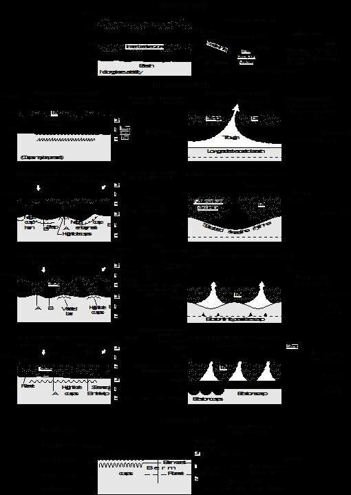
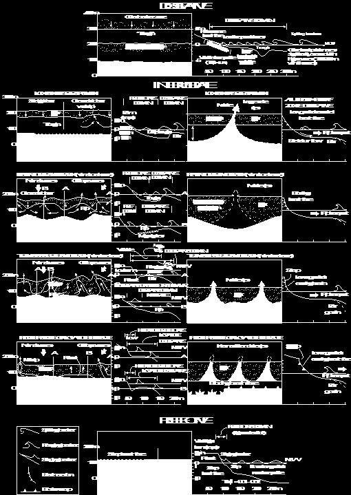
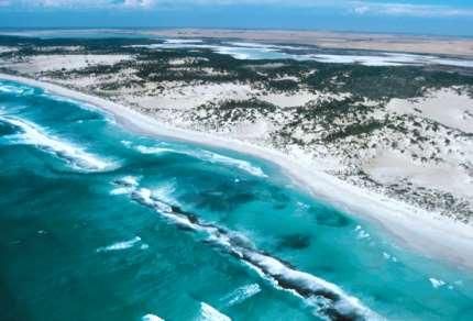
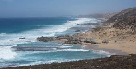
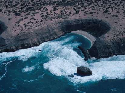
8 Wave-dominated type 6 beach states from Short, 1999


9 Wave dominated beach states dissipative intermediate a c c r e t i o n e r o s i o n reflective

10 Wave-dominated accretionary beach states rip circulation dominated the four intermediate states LBT RBB TBR LTT

 Permanent")
 LBT RBB TBR LTT")
11 Wave-dominated & some tide-modified 4 types of rips Rip Currents Beach (WD & TM) Topographic Accretion (fixed) Erosion (mobile) Permanent (structurally controlled) Mega (embayment controlled) LBT RBB TBR LTT LBT' RBB' TBR' LTT' (flash)


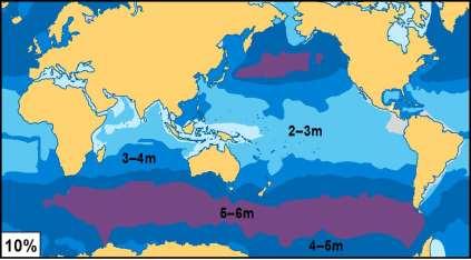
12 high waves + micro tides = +

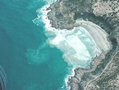
13 6m 11 m Likewise Brazil 6 m has a tropical 4 m high tide low waves 2 m north coast 2 m & low tide high waves south coast 1 m 1 m
14 Brazilian embayed (headland-bay beaches) Klein & Menezes, 2001 Klein, et al., 2010 Silveira, Klein & Tessler, 2010 Considerable research in SC & SP states on beach plan form stability rotation morphodynamics
15 Relative tide range Sand size (mm) Wave height (m) Wave-dom TM TD (a) Environmental characteristics of Australian beaches (Short, 2006) (b) Wave -dominated 1 = reflective 2 = LTT 3 = TBR 4 = RBB 5 = LBT 6 = Dissipative (c) Tide-modified Beach type Tide-dominated 10-13

16 Average beach length = 1.4 km
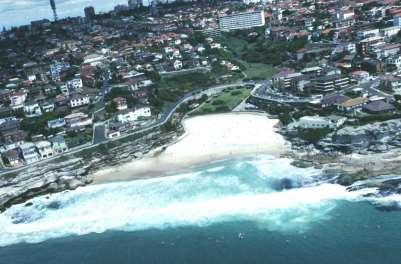
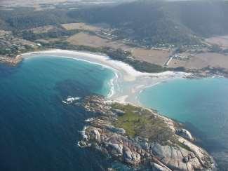
17 Embayed beaches role of geological inheritance/structures topographically and/or structurally-controlled beaches impact on beach morphodynamics Definitions: Embayed beaches are bounded by either headland and/or structures, which play a role in beach morphodynamics. Headland embayed beaches are characteristic of rocky shorelines associated with hilly and mountainous coastal topography. In Australia beaches average length of 1.4 km (s = 4.6), with most of them bounded by headlands at each end. Structurally embayed beaches are more common in groyne fields & adjacent to major coastal structures such as training walls and breakwaters.
 normally > ~200 m in length (embayed) Pocket")
 normally less than ~200 m in length")
18 Definitions Embayed beach structurally bound beach where part of the beach has normal circulation (under normal wave conditions) normally > ~200 m in length (embayed) Pocket beach small structurally bound beach where the circulation is always structurally-controlled (under normal wave conditions) normally less than ~200 m in length (ie one rip cell) embayed pocket


19 Embayed beaches, headland & structurally controlled beaches Australia: average beach length = 1.4 km

20 Pocket beaches

21 Other forms of topographic-control rocks, reefs, rock flats, islets, islands, etc Beachrock reefs


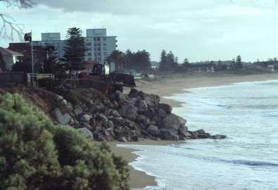
22 Forms of structural control groynes training walls/jetties seawall
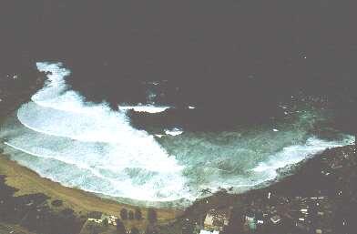
23 Embayed beach morphodynamics Headlands, rocks, reef and structures will all impact the beach and surf zone through their influence on wave refraction and attenuation, by impacting longshore currents, rips and rip feeder currents, and interrupting longshore sediment transport When deepwater waves (H o2 ) enter an embayment with a given width (C l ) then the wave energy will be redistributed along the embayment shoreline (S l ) Embayment scaling parameter ' where ' = S l2 /100 C l H b

24 role of embaymentisation in beach & topographic rips embaymentisation parameter = S 2 l / 100 C l H b > 19 normal beach circulation = 8-19 transitional < 8 cellular (modified from Short & Masselink, 1999)


25 Decreasing embayment length = S 2 l / 100 C l H b Normal Transitional Cellular

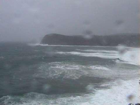
26 Increasing wave height = S 2 l / 100 C l H b Transitional Megarip
27 Topographic-rip topographically-controlled rip Mega-rip large scale (high energy) topographically controlled rip Rip Currents Beach (WD & TM) Topographic Accretion (fixed) Erosion (mobile) Permanent (structurally controlled) Mega (embayment controlled) LBT RBB TBR LTT LBT' RBB' TBR' LTT' (flash)
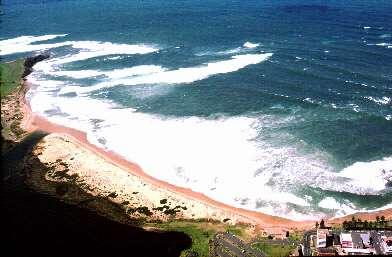
28 topographic & megarips


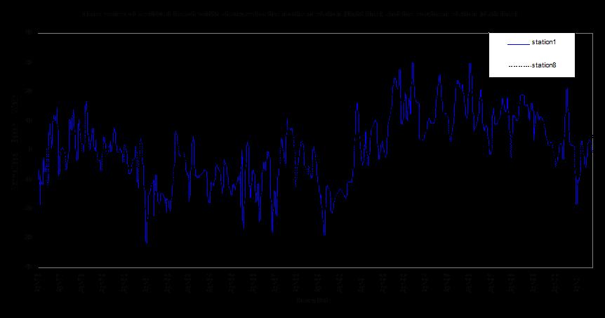
29 0 s 60 s Megarip pulsing 120 s 150 s
30 Megarip H b 4-5m, 150 s broken waves megarip head
31 Megarips: large scale topographically controlled cellular circulation Velocities up to 3 m/sec Transport more sand Transport coarser sand Transport sand further seaward (~1-2 km) Transport sand to great depths Result in rapid & severe beach erosion Greatest erosion in lee of rip Slower beach recovery (2-5 years) Some sand may be lost permanently offshore &/or longshore
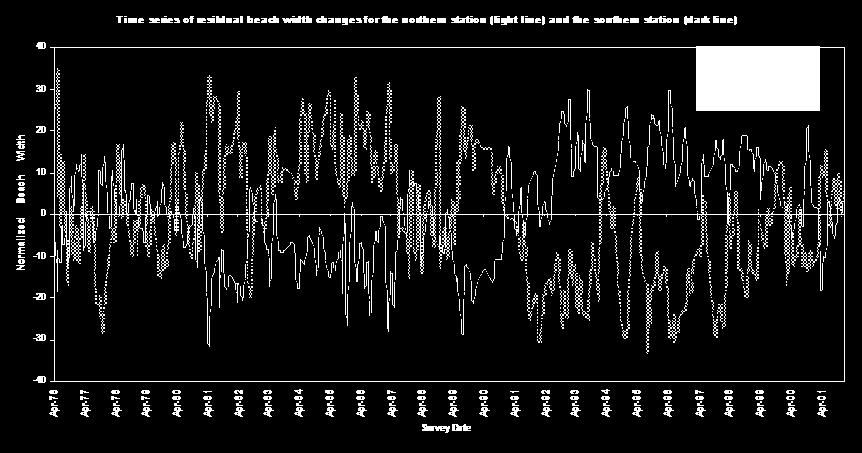
32 Global rip current spacing (Short & Brander, 1999) Spacing Seas 80 m East coast swell 200 m West coast swell 500 m Muriwai, NZ 760 m

33 m m


34 short period sea coast long period swell coast ~100 m spacing ~400 m spacing

35 ~250 m spacing, south eastern Australia
36 Topographic effects on sediment transport, with a variable directional wave climate Embayment beaches = beach rotation Longer beaches with headland = headland bypassing
37 Beach rotation periodic accumulation of sand towards at alternating ends of an embayed beach manifest by the rotation in the beach plan form

38 Beach rotation owing to changes in wave direction
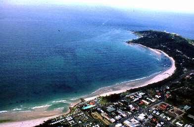
 North Narrabeen")
39 Narrabeen beach: site of monthly beach surveys since 1976 (37 yr) North Narrabeen surf
40
41 Correlation between Narrabeen beach profiles north end (profile 1) south end (profile 8) Note: Beach rotation accounts for 30% of profile changes Beach oscillation however dominates and accounts for 70%
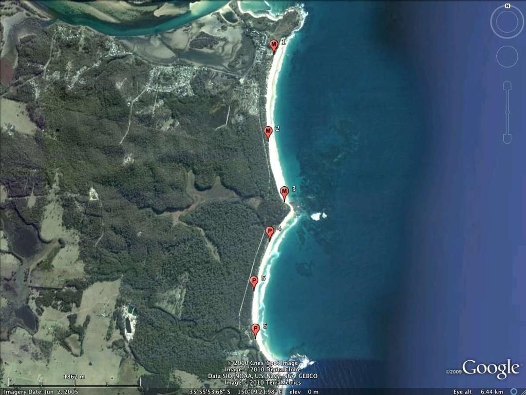
42 Moruya-Pedro beaches

43 Moruya Série1 Série2 Série3 Série4 Série5 Série6 Série7 40m Moruya Série1 Série2 Série3 Série4 Hb ~0.5-1 m R-LTT 200 Série5 100 Série Série7 Série8 50m Moruya Série1 Série2 Série3 200 Série Série5 Série6 Série7
44 Residuals Moruya 1, 2 & Moruya 1 (N) Moruya 2 (C) Moruya 3 (S) Residuals Moruya 1 & Moruya 1 (N) Moruya 3 (S)

45 Pedro 4 60m Série1 Série2 Série3 Série4 Série5 Série6 Série7 Pedro 5 40m Hb~1.5 m TBR-RBB Pedro 6 Série1 Série2 Série3 Série4 Série5 Série6 Série
46 40 Residuals Pedro 4, 5 & Pedro 4 (N) Pedro 5 (C) Pedro 6 (S) Residuals Pedro 4 & Pedro 4 (N) Pedro 6 (S)
 -20-30 -40-50 40 30 20 10 0-10 1 3 5 7 9 11 13 15 17 19 21 23 25 27 Pedro 4 (N) Pedro 6 (S)")
47 Moruya 1 (N) Moruya 3 (S) Pedro 4 (N) Pedro 6 (S)
48 Beach rotation role of wave direction in beach change a major component of change in affected beaches explains variable accretion-erosion along beaches relation to climate indices (inc. SOI/ENSO) Circum-Pacific wave-beach study
49 Headland (sand) bypassing Refers to the subaqueous transport of sand around headlands to the downdrift beach system Tends to occur on longer headland bound beaches Periodic pulses of sand move sub-aqueously around the headland Manifest on downdrift side as subaerial sand spits


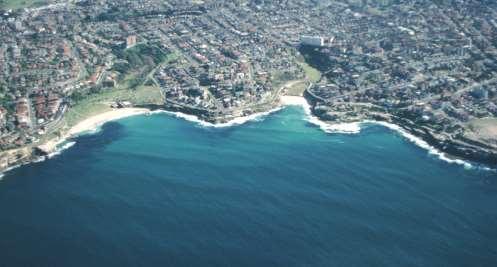
50 Headland sand bypassing Cape Byron Byron Bay Double Is Pt


51 Brunswick Heads, NSW note updrift accumulation downdrift erosion rip sand wave Kingscliff, NSW sand wave


52 Sand wave & topographic rip Sand wave Topographic rip & beach erosion


53 topo rip sand wave Beach erosion caused by migrating topographic rip in front of sand wave
54 Headland (sand) bypassing Implications: The more sheltered southern end of beaches can undergo severe erosion during calm conditions as the topographic rip precedes the sand wave


55 sand wave Headland bypassing appears common on a number of embayed Brazilian beaches Forte & Enseada, SC sand wave

56 Tourism image of Touros, RN showing attached sand wave & backing lagoon sand wave lagoon

57 Headland (sand) overpassing aeolian transport of sand across a headland to the downdrift beach system very common in Brazil and South Africa occurs in parts of southern Australia

58 Ingleses, SC


59 Groynes shore perpendicular structures across beach &/or surf zone deflect longshore current seaward topographic rip hinder longshore transport- updrift accretion, downdrift erosion more cellular circulation greater seaward transport greater beach erosion cellular topo-rips
60 Impact of groynes on beach morphodynamics induces more topographically (groyne) controlled rip currents therefore greater offshore flow, sand transport & beach erosion no groynes groynes

61 groynes at Imbituba, SC
62 Wave-dominated embayed beaches Summary All beaches crossed or bordered by headlands and structures are directly impacted by the nature and scale of the boundary Greater wave refraction = greater beach curvature Greater wave attenuation = lower energy beaches & beach state The degree of impact increases with decreasing spacing between embayment ends, and increasing seaward protrusion of the ends.
63 Summary 1 wave refraction modifies wave direction at the shoreline leading to greater beach curvature 2 modification of breaker wave height owing to wave refraction, diffraction and attenuation, will in turn lead to a longshore variation in breaker height and thereby beach type 3 increasing embaymentization will progressively shift in beach type from normal to transitional to cellular circulation, whereby the structure/s may totally dominates the circulation. 4 they will usually realign of the shoreline by processes of wave refraction, increased rip-cellular circulation and updrift accumulation & downdrift erosion 5 any structures located across the beach and surf zone, will stop &/or interrupt longshore sand transport (rotation, bypassing, overpassing) & may generate greater offshore transport

64 Thank you - obrigado
Nearshore Morphodynamics. Bars and Nearshore Bathymetry. Sediment packages parallel to shore, that store beach sediment
 Nearshore Morphodynamics http://coastal.er.usgs.gov/bier/images/chandeleur-xbeach-lg.jpg Bars and Nearshore Bathymetry Sediment packages parallel to shore, that store beach sediment Can be up to 50 km
OECS Regional Engineering Workshop September 29 October 3, 2014
 B E A C H E S. M A R I N A S. D E S I G N. C O N S T R U C T I O N. OECS Regional Engineering Workshop September 29 October 3, 2014 Coastal Erosion and Sea Defense: Introduction to Coastal Dynamics David
Australian Beach Systems Nature and Distribution
 Journal of Coastal Research 22 1 11 27 West Palm Beach, Florida January 26 Australian Beach Systems Nature and Distribution Andrew D. Short Coastal Studies Unit School of Geosciences University of Sydney
Marginal Marine Environments
 Marginal Marine Environments Delta: discrete shoreline protuberances formed where rivers enter oceans, semi-enclosed seas, lakes or lagoons and supply sediment more rapidly than it can be redistributed
Implications of changes to El Niño Southern Oscillation for coastal vulnerability in NSW
 Implications of changes to El Niño Southern Oscillation for coastal vulnerability in NSW By Thomas Mortlock (Thomas.mortlock@mq.edu.au) El Niño Southern Oscillation (ENSO) has a strong impact on weather
Chapter 10 Lecture Outline. The Restless Oceans
 Chapter 10 Lecture Outline The Restless Oceans Focus Question 10.1 How does the Coriolis effect influence ocean currents? The Ocean s Surface Circulation Ocean currents Masses of water that flow from one
There are many different kinds of beaches which are generally characterized by the dominance of waves, tides, rivers and currents, and in particular
 Fig. 11-11, p. 253 There are many different kinds of beaches which are generally characterized by the dominance of waves, tides, rivers and currents, and in particular differ by the amount of energy, which
LAB: WHERE S THE BEACH
 Name: LAB: WHERE S THE BEACH Introduction When you build a sandcastle on the beach, you don't expect it to last forever. You spread out your towel to sunbathe, but you know you can't stay in the same spot
Beach Nourishment Impact on Beach Safety and Surfing in the North Reach of Brevard County, Florida
 Beach Nourishment Impact on Beach Safety and Surfing in the North Reach of Brevard County, Florida Prepared by John Hearin, Ph.D. Coastal Engineering Vice Chairman Cocoa Beach Chapter Port Canaveral Patrick
Earth Science Chapter 16 Section 3 Review
 Name: Class: Date: Earth Science Chapter 16 Section 3 Review Multiple Choice Identify the choice that best completes the statement or answers the question. 1. The movement of water that parallels the shore
Undertow - Zonation of Flow in Broken Wave Bores
 Nearshore Circulation Undertow and Rip Cells Undertow - Zonation of Flow in Broken Wave Bores In the wave breaking process, the landward transfer of water, associated with bore and surface roller decay
Lecture Outlines PowerPoint. Chapter 15 Earth Science, 12e Tarbuck/Lutgens
 Lecture Outlines PowerPoint Chapter 15 Earth Science, 12e Tarbuck/Lutgens 2009 Pearson Prentice Hall This work is protected by United States copyright laws and is provided solely for the use of instructors
Reading Material. Inshore oceanography, Anikouchine and Sternberg The World Ocean, Prentice-Hall
 Reading Material Inshore oceanography, Anikouchine and Sternberg The World Ocean, Prentice-Hall BEACH PROCESSES AND COASTAL ENVIRONMENTS COASTAL FEATURES Cross section Map view Terminology for Coastal
Deep-water orbital waves
 What happens when waves approach shore? Deep-water orbital waves Fig. 9.16, p. 211 Wave motion is influenced by water depth and shape of the shoreline wave buildup zone surf zone beach Wave base deepwater
Chapter. The Dynamic Ocean
 Chapter The Dynamic Ocean An ocean current is the mass of ocean water that flows from one place to another. 16.1 The Composition of Seawater Surface Circulation Surface Currents Surface currents are movements
Oceans and Coasts. Chapter 18
 Oceans and Coasts Chapter 18 Exploring the oceans The ocean floor Sediments thicken and the age of the seafloor increases from ridge to shore The continental shelf off the northeast United States Constituent
Shoreline Response to an Offshore Wave Screen, Blairgowrie Safe Boat Harbour, Victoria, Australia
 Shoreline Response to an Offshore Wave Screen, Blairgowrie Safe Boat Harbour, Victoria, Australia T.R. Atkins and R. Mocke Maritime Group, Sinclair Knight Merz, P.O. Box H615, Perth 6001, Australia ABSTRACT
Shorelines Earth - Chapter 20 Stan Hatfield Southwestern Illinois College
 Shorelines Earth - Chapter 20 Stan Hatfield Southwestern Illinois College The Shoreline A Dynamic Interface The shoreline is a dynamic interface (common boundary) among air, land, and the ocean. The shoreline
Australian Coastal Councils Conference
 Australian Coastal Councils Conference Kiama March 2019 Where Has My Beach Gone? (and what can I do about it?) Dr Andrew McCowan Water Technology Where Has My Beach Gone? Where Has My Beach Gone? Where
Improving predictions of nearshore processes and shoreline dynamics for beaches along Australia s rocky and coral reef coasts
 Improving predictions of nearshore processes and shoreline dynamics for beaches along Australia s rocky and coral reef coasts Ryan Lowe Jeff Hansen, Graham Symonds, Mark Buckley, Andrew Pomeroy, Gundula
COASTAL ENVIRONMENTS. 454 lecture 12
 COASTAL ENVIRONMENTS Repeated movement of sediment & water constructs a beach profile reflecting the balance between average daily or seasonal wave forces and resistance of landmass to wave action Coasts
Coastal waves, water levels, beach dynamics and climate change
 Coastal waves, water levels, beach dynamics and climate change Michael Hughes, University of Sydney Wave generation in the ocean The waves most readily observed at the coast are those generated by the
Undertow - Zonation of Flow in Broken Wave Bores
 Lecture 22 Nearshore Circulation Undertow - Zonation of Flow in Broken Wave Bores In the wave breaking process, the landward transfer of water, associated with bore and surface roller decay within the
Chapter - Oceans and Coasts
 Chapter - Oceans and Coasts Discussion: What do oceans contribute to the environment of Earth? How do Earth s major systems relate to the oceans? Oceans and Coasts Oceans are important - Thermal regulation
MIAMI BEACH 32ND STREET HOT SPOT: NUMERICAL MODELING AND DESIGN OPTIMIZATION. Adam Shah - Coastal Engineer Harvey Sasso P.E.
 ABSTRACT MIAMI BEACH 32ND STREET HOT SPOT: NUMERICAL MODELING AND DESIGN OPTIMIZATION Adam Shah - Coastal Engineer Harvey Sasso P.E. - Principal Coastal Systems International, Inc. 464 South Dixie Highway
ALTERNATIVES FOR COASTAL STORM DAMAGE MITIGATION
 ALTERNATIVES FOR COASTAL STORM DAMAGE MITIGATION Dave Basco Old Dominion University, Norfolk, Virginia, USA National Park Service Photo STRUCTURAL (changes to natural, physical system) hardening (seawalls,
Variation in Beach Profile and Sediment Characteristics at Popham Beach, Phippsburg, ME
 Colby College Digital Commons @ Colby Undergraduate Research Symposium Student Research 2006 Variation in Beach Profile and Sediment Characteristics at Popham Beach, Phippsburg, ME Kathryn Lidington Colby
USE OF SEGMENTED OFFSHORE BREAKWATERS FOR BEACH EROSION CONTROL
 .. CETN-III-22 4/84 PURPOSE: USE OF SEGMENTED OFFSHORE BREAKWATERS FOR BEACH EROSION CONTROL To provide information on the functional application of and general design considerations for using offshore
HIGH VOLUME SEDIMENT TRANSPORT AND ITS IMPLICATIONS FOR RECREATIONAL BEACH RISK
 HIGH VOLUME SEDIMENT TRANSPORT AND ITS IMPLICATIONS FOR RECREATIONAL BEACH RISK Tim Scott 1, Paul Russell 1, Gerhard Masselink 1, Adam Wooler 2 and Andrew Short 3 In a coastal region where there are large
BEACH PROCESSES AND COASTAL ENVIRONMENTS
 BEACH PROCESSES AND COASTAL ENVIRONMENTS COASTAL FEATURES Cross section Map view TOPICS: Terminology Waves Beach Morphology Barriers Coastal Migration Tides Tidal Flats and Marshes Sediment Budgets Human
Nearshore Sediment Transport What influences the loss of sediment on Beaches? - Waves - Winds - Tidal Currents - River discharge - Runoff
 Tides & Beaches Nearshore Sediment Transport What influences the loss of sediment on Beaches? - Waves - Winds - Tidal Currents - River discharge - Runoff Oceans Ocean Topography Physical Structure of the
CHAPTER 134 INTRODUCTION
 CHAPTER 134 NEW JETTIES FOR TUNG-KANG FISHING HARBOR, TAIWAN Chi-Fu Su Manager Engineering Department Taiwan Fisheries Consultants, Inc. Taipei, Taiwan INTRODUCTION Tung-Kang Fishing Harbor, which is about
Low-crested offshore breakwaters: a functional tool for beach management
 Environmental Problems in Coastal Regions VI 237 Low-crested offshore breakwaters: a functional tool for beach management K. Spyropoulos & E. Andrianis TRITON Consulting Engineers, Greece Abstract Beach
Q1. What are the primary causes/contributors to coastal erosion at Westshore and the concept of longshore / littoral drift.
 Q1. What are the primary causes/contributors to coastal erosion at Westshore and the concept of longshore / littoral drift. In order of (timing related) contribution to present problem 1. Beach is too
3/9/2013. Build house on cliff for a view of the ocean - be one with said view Pearson Education, Inc. Shorelines: summary in haiku form
 Introduction to Environmental Geology, 5e Edward A. Keller Shorelines: summary in haiku form Chapter 11 Coastal Processes Lecture Presentation prepared by X. Mara Chen, Salisbury University Build house
page - Laboratory Exercise #5 Shoreline Processes
 page - Laboratory Exercise #5 Shoreline Processes Section A Shoreline Processes: Overview of Waves The ocean s surface is influenced by three types of motion (waves, tides and surface currents). Shorelines
ALTERNATIVES FOR COASTAL STORM DAMAGE MITIGATION AND FUNCTIONAL DESIGN OF COASTAL STRUCTURES
 The University of the West Indies Organization of American States PROFESSIONAL DEVELOPMENT PROGRAMME: COASTAL INFRASTRUCTURE DESIGN, CONSTRUCTION AND MAINTENANCE A COURSE IN COASTAL DEFENSE SYSTEMS I CHAPTER
IMPACTS OF COASTAL PROTECTION STRATEGIES ON THE COASTS OF CRETE: NUMERICAL EXPERIMENTS
 IMPACTS OF COASTAL PROTECTION STRATEGIES ON THE COASTS OF CRETE: NUMERICAL EXPERIMENTS Tsanis, I.K., Saied, U.M., Valavanis V. Department of Environmental Engineering, Technical University of Crete, Chania,
Volume and Shoreline Changes along Pinellas County Beaches during Tropical Storm Debby
 Volume and Shoreline Changes along Pinellas County Beaches during Tropical Storm Debby Ping Wang and Tiffany M. Roberts Coastal Research Laboratory University of South Florida July 24, 2012 Introduction
Overview. Beach Features. Coastal Regions. Other Beach Profile Features. CHAPTER 10 The Coast: Beaches and Shoreline Processes.
 Overview CHAPTER 10 The Coast: Beaches and Shoreline Processes Coastal regions constantly change. The beach is a dominant coastal feature. Wave activity continually modifies the beach and coastal areas.
Anatomy of Coastal Regions
 The Coast I. BEACH ANATOMY Anatomy of Coastal Regions Terms for different parts of beaches and coastal regions Are all about ENERGY- ie, where the ocean s energy Mostly through tides and waves, and shape
CHAPTER 281 INFLUENCE OF NEARSHORE HARDBOTTOM ON REGIONAL SEDIMENT TRANSPORT
 CHAPTER 281 INFLUENCE OF NEARSHORE HARDBOTTOM ON REGIONAL SEDIMENT TRANSPORT Paul C.-P. Lin, Ph.D., P.E. 1 and R. Harvey Sasso, P.E. 2 ABSTRACT The influence of nearshore hardbottom on longshore and cross-shore
Beach profile surveys and morphological change, Otago Harbour entrance to Karitane May 2014 to June 2015
 Beach profile surveys and morphological change, Otago Harbour entrance to Karitane May 2014 to June 2015 Prepared for Port Otago Ltd Martin Single September 2015 Shore Processes and Management Ltd Contact
/50. Physical Geology Shorelines
 Physical Geology Shorelines Multiple Guess: (You know the drill 2 points each) 1. The path of movement of a water particle in a wave at sea is 1. circular 2. horizontal 3. vertical 4. elliptical 5. none
Chapter 12: Coasts (after a brief review of Tides)
") Chapter 12: Coasts (after a brief review of Tides) 1 Questions from previous classes: What happens when a wave meets a current? wave = people walking current = bus If wave goes with the current, the wave
Chapter 12: Coasts (after a brief review of Tides) 1 Questions from previous classes: What happens when a wave meets a current? wave = people walking current = bus If wave goes with the current, the wave
CROSS-SHORE SEDIMENT PROCESSES
 The University of the West Indies Organization of American States PROFESSIONAL DEVELOPMENT PROGRAMME: COASTAL INFRASTRUCTURE DESIGN, CONSTRUCTION AND MAINTENANCE A COURSE IN COASTAL DEFENSE SYSTEMS I CHAPTER
Ocean Waves. Capillary. Gravity. Wind generated. Tides Tsunamis Seiches
 Ocean Waves Capillary Wind generated Gravity Tides Tsunamis Seiches Capillary waves are driven by the surface tension produced by electrically polarized water molecule San Pedro Lighthouse Waves are alternate
STATUS REPORT FOR THE SUBMERGED REEF BALL TM ARTIFICIAL REEF SUBMERGED BREAKWATER BEACH STABILIZATION PROJECT FOR THE GRAND CAYMAN MARRIOTT HOTEL
 August 23 STATUS REPORT FOR THE SUBMERGED REEF BALL TM ARTIFICIAL REEF SUBMERGED BREAKWATER BEACH STABILIZATION PROJECT FOR THE GRAND CAYMAN MARRIOTT HOTEL performed by Lee E. Harris, Ph.D., P.E. Consulting
Impacts of breakwaters and training walls
 Across the eastern seaboard of Australia, breakwaters and training walls have instigated fundamental perturbations to coastal and estuary processes. This has induced long-term changes to foreshore alignments,
New Jersey Coastal Zone Overview. The New Jersey Beach Profile Network (NJBPN) 3 Dimensional Assessments. Quantifying Shoreline Migration
 3 Dimensional Assessments. Quantifying Shoreline Migration") New Jersey Coastal Zone Overview The New Jersey Beach Profile Network (NJBPN) Objectives Profile Locations Data Collection Analyzing NJBPN Data Examples 3 Dimensional Assessments Methodology Examples Quantifying
New Jersey Coastal Zone Overview The New Jersey Beach Profile Network (NJBPN) Objectives Profile Locations Data Collection Analyzing NJBPN Data Examples 3 Dimensional Assessments Methodology Examples Quantifying
NORTHERN CELL OPTIONS SHORTLIST RECOMMENDATIONS
 OPTIONS SHORTLIST RECOMMENDATIONS Coastal Unit C: Bayview Options recommended for MCDA scoring. Status quo. Planting 3. Renourishment (gravel) 6. Beach-scraping 7. Restore shingle crest. Inundation accommodation
SELECTION OF THE PREFERRED MANAGEMENT OPTION FOR STOCKTON BEACH APPLICATION OF 2D COASTAL PROCESSES MODELLING
 SELECTION OF THE PREFERRED MANAGEMENT OPTION FOR STOCKTON BEACH APPLICATION OF 2D COASTAL PROCESSES MODELLING C Allery 1 1 DHI Water and Environment, Sydney, NSW Abstract This paper presents an approach
The evolution of beachrock morphology and its influence on beach morphodynamics
 The evolution of beachrock morphology and its influence on beach morphodynamics Robert J. Turner Division of Natural Sciences, Southampton College, 239 Montauk Highway, Southampton, NY 11968, U.S.A. email:
Artificial headlands for coastal restoration
 Artificial headlands for coastal restoration J. S. Mani Professor, Department of Ocean Engineering, Indian Institute of Technology Madras, Chennai 636, India Abstract Construction of a satellite harbour
ACOUSTIC DOPPLER CURRENT PROFILING FROM KIRRA BEACH TO COOK ISLAND FIELD EXERCISES UNDERTAKEN BY THE TWEED RIVER ENTRANCE SAND BYPASSING PROJECT
 ACOUSTIC DOPPLER CURRENT PROFILING FROM KIRRA BEACH TO COOK ISLAND FIELD EXERCISES UNDERTAKEN BY THE TWEED RIVER ENTRANCE SAND BYPASSING PROJECT Z Helyer 1, C Acworth 1, K Nielsen 1, 1 Coastal Impacts
The Composition of Seawater
 The Composition of Seawater Salinity Salinity is the total amount of solid material dissolved in water. Most of the salt in seawater is sodium chloride, common table salt. Element Percent Element Percent
To: William Woods, Jenni Austin Job No: CentrePort Harbour Deepening Project - Comments on community queries
 Memo To: William Woods, Jenni Austin From: Richard Reinen-Hamill Date: Subject: cc: 1 Purpose This memo sets out our response to issues raised at and after Seatoun community consultation sessions held
The Dynamic Coast. Right Place Resources. A presentation about the interaction between the dynamic coast and people
 The Dynamic Coast Houses threatened by coastal erosion in California Right Place Resources A presentation about the interaction between the dynamic coast and people For the rest of the presentations in
Advanced Series on Ocean Engineering - Volume 14 COASTAL STABILIZATION. Richard Silvester John R C Hsu. \v? World Scientific
 Advanced Series on Ocean Engineering - Volume 14 COASTAL STABILIZATION Richard Silvester John R C Hsu \v? World Scientific Contents PREFACE xv 1 INTRODUCTION 1 /. / Coastal Environment 2 J.2 State of Beach
Essentials of Oceanography Eleventh Edition
 Chapter Chapter 1 10 Clickers Lecture Essentials of Oceanography Eleventh Edition The Coast: Beaches and Shoreline Processes Alan P. Trujillo Harold V. Thurman Chapter Overview Coastal regions have distinct
Chapter 11. Beach Fill and Soft Engineering Structures
 Chapter 11 Beach Fill and Soft Engineering Structures Solutions to Coastal Erosion Soft Structures Hard Structures Retreat No such thing as low cost coastal protection Beach Nourishment Beach Filling Beach
Chapter 20 Lecture. Earth: An Introduction to Physical Geology. Eleventh Edition. Shorelines. Tarbuck and Lutgens Pearson Education, Inc.
 Chapter 20 Lecture Earth: An Introduction to Physical Geology Eleventh Edition Shorelines Tarbuck and Lutgens The Shoreline: A Dynamic Interface The Coastal Zone The shoreline is constantly modified by
NORTH HAVEN NORTH HAVEN SLSC
 NORTH HAVEN NORTH HAVEN SLSC Patrols: November to March, weekends and public holidays North Haven beach is the product of a major redevelopment of the northern part of the Adelaide coast. In the 1980s,
DUXBURY WAVE MODELING STUDY
 DUXBURY WAVE MODELING STUDY 2008 Status Report Duncan M. FitzGerald Peter S. Rosen Boston University Northeaster University Boston, MA 02215 Boston, MA 02115 Submitted to: DUXBURY BEACH RESERVATION November
COFFS HARBOUR SEDIMENT MODELLING AND INVESTIGATION
 COFFS HARBOUR SEDIMENT MODELLING AND INVESTIGATION Luke McAvoy Undergraduate Engineer (Civil) Griffith School of Engineering, Griffith University, Gold Coast, Australia Daniel Rodger Senior Engineer Water
Environmental Geology Chapter 11 COASTAL PROCESSES and RELATED HAZARDS
 Environmental Geology Chapter 11 COASTAL PROCESSES and RELATED HAZARDS Introduction >50% of world population concentrated in the coastal zones ~75% of U.S. population living in coastal states Coastal hazard
Shore - place where ocean meets land Coast - refers to the larger zone affected by the processes that occur at this boundary.
 Waves, Beaches, and Coasts Shore - place where ocean meets land Coast - refers to the larger zone affected by the processes that occur at this boundary. Waves: energy moving through water The height of
Technical Note AN EMPIRICAL. METHOD FOR DESIGN OF BREAKWATERS AS SHORE PROTECTION STRUCTURES
 CETN III-23 (Rev 3/95) Coastal Engineering Technical Note AN EMPIRICAL. METHOD FOR DESIGN OF BREAKWATERS AS SHORE PROTECTION STRUCTURES PURPOSE: To present an empirical method that can be used for preliminary
LITTLE LAGOON & LITTLE LAGOON PASS: RESEARCH UPDATES & DIRECTIONS
 LITTLE LAGOON & LITTLE LAGOON PASS: RESEARCH UPDATES & DIRECTIONS Bret M. Webb, PhD, PE, DCE Professor Department of Civil, Coastal, and Environmental Engineering October 19, 2017 LLPS Meeting Acknowledgments
Coastal management has lagged behind the growth in population leading to problems with pollution
 Fifty percent of the population of the industrialized world lives within 100 km of a coast. Coastal management has lagged behind the growth in population leading to problems with pollution and natural
BYPASS HARBOURS AT LITTORAL TRANSPORT COASTS
 BYPASS HARBOURS AT LITTORAL TRANSPORT COASTS by K. Mangor 1, I. Brøker 2, R. Deigaard 3 and N. Grunnet 4 ABSTRACT Maintaining sufficient navigation depth in front of the entrance at harbours on littoral
4/20/17. #30 - Coastlines - General Principles Coastlines - Overview
 Writing Assignment Due one week from today by 11:59 pm See main class web pages for detailed instructions Essays will be submitted in Illinois Compass (instructions later) Pick one: Earthquakes, tsunamis,
Coasts. 1. Coastal Processes. 1.1 Coastal erosion. 1.2 Sediment transport. Coastal Processes and Landforms. i. Hydraulic action
 Coasts Coastal Processes and Landforms 1. Coastal Processes 1.1 Coastal erosion i. Hydraulic action When waves strike against a rock surface, the waves trap air in the rock joints. This air is compressed
INTRODUCTION TO COASTAL ENGINEERING AND MANAGEMENT
 Advanced Series on Ocean Engineering Volume 16 INTRODUCTION TO COASTAL ENGINEERING AND MANAGEMENT J. William Kamphuis Queen's University, Canada World Scientific Singapore New Jersey London Hong Kong Contents
G. Meadows, H. Purcell and L. Meadows University of Michigan
 www.coj.net/departments/fire+and+rescue/emergency+preparedness/rip+current.htm G. Meadows, H. Purcell and L. Meadows Over 80% of all surf related rescues are attributable to Rip Currents According to the
The Physical and Human Causes of Erosion. The Holderness Coast
 The Physical and Human Causes of Erosion The Holderness Coast By The British Geographer Situation The Holderness coast is located on the east coast of England and is part of the East Riding of Yorkshire;
Dynamic Shoreline. Why do we care? Loss of land Damage to structures Recreation
 Dynamic Shoreline Why do we care? Loss of land Damage to structures Recreation Coastal Water Movement Waves provide the energy Through breaking As waves shoal Speed decreases Height increases Wavelength
Julebæk Strand. Effect full beach nourishment
 Julebæk Strand Effect full beach nourishment Aim of Study This study is a part of the COADAPT funding and the aim of the study is to analyze the effect of beach nourishment. In order to investigate the
Coastal Zones. Coastal Zones
 Page 1 of 15 EENS 3050 Tulane University Natural Disasters Prof. Stephen A. Nelson Coastal Zones Coastal Zones A coastal zone is the interface between the land and water. These zones are important because
MESSOLOGI LAGOON AREA (GREECE)
") MESSOLOGI LAGOON AREA (GREECE) 20 Contact: Kyriakos SPYROPOULOS TRITON Consulting Engineers 90 Pratinou Str. 11634 Athens (GREECE) Tel: +32 10 729 57 61 Fax: +32 10 724 33 58 e-mail: kspyropoulos@tritonsa.gr
MESSOLOGI LAGOON AREA (GREECE) 20 Contact: Kyriakos SPYROPOULOS TRITON Consulting Engineers 90 Pratinou Str. 11634 Athens (GREECE) Tel: +32 10 729 57 61 Fax: +32 10 724 33 58 e-mail: kspyropoulos@tritonsa.gr
MODELLING THE SHORELINE IMPACTS OF RICHMOND RIVER TRAINING WALLS
 MODELLING THE SHORELINE IMPACTS OF RICHMOND RIVER TRAINING WALLS D Patterson 1 1 BMT WBM / University Of Qld, Brisbane, QLD Introduction The construction of river entrance training walls is generally aimed
Nearshore Placed Mound Physical Model Experiment
 Nearshore Placed Mound Physical Model Experiment PURPOSE: This technical note describes the migration and dispersion of a nearshore mound subjected to waves in a physical model. The summary includes recommendations
HURRICANE SANDY LIMITED REEVALUATION REPORT UNION BEACH, NEW JERSEY DRAFT ENGINEERING APPENDIX SUB APPENDIX D SBEACH MODELING
 HURRICANE SANDY LIMITED REEVALUATION REPORT UNION BEACH, NEW JERSEY DRAFT ENGINEERING APPENDIX SUB APPENDIX D SBEACH MODELING Rev. 18 Feb 2015 1 SBEACH Modeling 1.0 Introduction Following the methodology
Modeling Beach Erosion
 Ocean Lecture & Educator s Night May 16, 2012 Modeling Beach Erosion Below is an overview of the activity Modeling Beach Erosion (New Jersey Sea Grant Consortium, Education Program) to incorporate information
RIP CHANNEL MORPHODYNAMICS AT PENSACOLA BEACH, FLORIDA. A Thesis DANIEL R. LABUDE
 RIP CHANNEL MORPHODYNAMICS AT PENSACOLA BEACH, FLORIDA A Thesis by DANIEL R. LABUDE Submitted to the Office of Graduate Studies of Texas A&M University in partial fulfillment of the requirements for the
General Coastal Notes + Landforms! 1
 General Coastal Notes + Landforms! 1 Types of Coastlines: Type Description Primary Coast which is essentially in the same condition when sea level stabilized Coastline after the last ice age, younger.
Inlet Management Study for Pass-A-Grille and Bunces Pass, Pinellas County, Florida
 Inlet Management Study for Pass-A-Grille and Bunces Pass, Pinellas County, Florida Final Report Submitted By Ping Wang, Ph.D., Jun Cheng Ph.D., Zachary Westfall, and Mathieu Vallee Coastal Research Laboratory
Imagine that you can see a side view of a wave as it approaches a beach. Describe how the wave changes as the wave approaches the beach.
 Geology 101 Name Reading Guide for Ch. 19: Shores and Coastal Processes (p. 612) Waves, Currents, and Tides (p. 614) Waves and Currents (p. 614) Imagine that you can see a side view of a wave as it approaches
Performance of Upham Beach T-Groin Project and Its Impact to the Downdrift Beach
 Performance of Upham Beach T-Groin Project and Its Impact to the Downdrift Beach Progress Report for the Period of October 2008 to April 2009 Submitted by Ping Wang, Ph.D., and Tiffany M. Roberts Department
Dune Monitoring Data Update Summary: 2013
 Dune Monitoring Data Update Summary: 13 Shoreline Studies Program Virginia Institute of Marine Science College of William & Mary Gloucester Point, Virginia September 13 Dune Monitoring Data Update Summary:
Beach Rescue Statistics and their Relation to Nearshore Morphology and Hazards: A Case Study for Southwest England
 Journal of Coastal Research SI 50 1-6 ICS2007 (Proceedings) Australia ISSN 0749.0208 Beach Rescue Statistics and their Relation to Nearshore Morphology and Hazards: A Case Study for Southwest England T.
Name Class Date. Use the terms from the following list to complete the sentences below. Each term may be used only once. Some terms may not be used.
 Assessment Chapter Test B The Movement of Ocean Water USING KEY TERMS Use the terms from the following list to complete the sentences below. Each term may be used only once. Some terms may not be used.
A process based approach to understand WA s complex coastline Jeff Hansen Ryan Lowe Graham Symonds Laura Segura Gundula Winter
 A process based approach to understand WA s complex coastline Jeff Hansen Ryan Lowe Graham Symonds Laura Segura Gundula Winter WA s coastline is highly variable due to offshore and shore-attached coral
Ch 9: Waves. Wind waves. Formation of a wind wave
 Ch 9: Waves 1. Features of Waves 2. Deep-water, shallow water and transitional waves 3. Breaking Waves 4. Wind Waves 5. Tsunamis Cf. Fig. 9-2 Waves are created by a disturbance. * wind (wind waves, L=
July 14, The Beaches Conference Greg Berman (WHOI Sea Grant & Cape Cod Cooperative Extension)
") July 14, 2017 The Beaches Conference 2017 Greg Berman (WHOI Sea Grant & Cape Cod Cooperative Extension) Annual downscaled global tropical cyclones, averaged over the six models. Uses data from IPCC Fifth
July 14, 2017 The Beaches Conference 2017 Greg Berman (WHOI Sea Grant & Cape Cod Cooperative Extension) Annual downscaled global tropical cyclones, averaged over the six models. Uses data from IPCC Fifth
Understanding the Tsunami Wave
 The First Tsunami attack on Sri Lanka Krakatoa Island 27 th August 1883 Understanding the Tsunami Wave Generation Propagation Nearshore Transformation Shoreline Entry Inland Dissipation 1 Generation and
OECS Regional Engineering Workshop September 29 October 3, 2014
 B E A C H E S. M A R I N A S. D E S I G N. C O N S T R U C T I O N. OECS Regional Engineering Workshop September 29 October 3, 2014 Coastal Erosion and Sea Defense: Introduction to Coastal/Marine Structures
HARBOUR SEDIMENTATION - COMPARISON WITH MODEL
 HARBOUR SEDIMENTATION - COMPARISON WITH MODEL ABSTRACT A mobile-bed model study of Pointe Sapin Harbour, in the Gulf of St. Lawrence, resulted in construction of a detached breakwater and sand trap to
CHAPTER 8 ASSESSMENT OF COASTAL VULNERABILITY INDEX
 124 CHAPTER 8 ASSESSMENT OF COASTAL VULNERABILITY INDEX 8.1 INTRODUCTION In order to assess the vulnerability of the shoreline considered under this study against the changing environmental conditions,
OCEANS. Main Ideas. Lesson 2: Ocean Currents Ocean Currents help distribute heat around Earth.
 Oceans Chapter 10 OCEANS Main Ideas Lesson 2: Ocean Currents Ocean Currents help distribute heat around Earth. Lesson 3: The Ocean Shore The shore is shaped by the movement of water and sand. OCEANS SO