Total Reported Incidents By Year: Total Reported Incidents :
|
|
|
- Melvin Johns
- 6 years ago
- Views:
Transcription

1 ! City of Sanibel MEMORANDUM May 29, 2012 TO: Judie Zimomra, City Manager FROM: Kimberly Greenplate, City Administrative Intern RE: Analysis of the Reported Bicycle and Pedestrian Incidents Background: This report is an analysis of the safety issues on the Shared Use Path, as called for the in Shared Use Path Master Plan. This analysis is based upon the bicycle and pedestrian incidents reported to the Sanibel Police Department between 2006 and For the purpose of this analysis, the types of incidents have been divided into three types of locations: on the Shared Use Path, at crosswalks and in parking lots. These reports have been analyzed based on total incident volume, incident type, location type, date of incident, time of incident, the age, residency and injuries of involved parties. Total Reported Incidents By Total Reported Incidents : Year Number of Reported Incidents !! 1


2 Specific Reported Incident Type Totals By Incident Type: Fell Off Bike Bike/ Car Bike/ Bike Ped./ Car Bike/ Sign Ped./ Bike Bike/ Dog Bike/ Tree Total Per Year Incident Total Specific Reported Incident Type Totals :! 12% 3% 4% 1% 1% 1% 30% 48% Fell Off Bike: 61 Bike/Car: 38 Bike/Bike: 16 Pedestrian/Car: 4 Bike/Sign: 5 Pedestrian/Bicycle: 2 Bike/Dog: 1 Bike/Tree: 1! 2


3 Locations of Reported Incidents by Where: Shared Use Path Crosswalks Parking Lots Total Locations of Reported Incidents : 13% 12% Shared Use Path: 96 73% Crosswalks: 17 Parking Lots: 15! 3
")


: 15 6% 22% 20% 18 -- 50: 39 51 --")

4 Ages of Involved Parties in Total Reported Incidents by Age Range: Under 18 (Juvenile) Over 80 Not Recorded Total Ages of Involved Parties in Total Reported Incidents : 13% 8% Under 18 (Juvenile): 15 6% 22% 20% : : : 42 31% Over 80: 12 Not Recorded: 25! 4


5 Residency of Involved Parties in Total Reported Incidents by Residency: Sanibel Lee County Florida Out of State Not Recorded Total Residency of Involved Parties in Total Reported Incidents : 16% 29% Sanibel: 55 Lee County: 22 Florida: 5 41% 11% 3% Out of State: 80 Not Given: 31! 5
6 Injuries of Involved Parties in Total Reported Incidents by Injuries: Yes No Transported to Hospital (if Yes or Injuries Not Recorded) Specific Injuries Not Recorded Total Note: Not every reported incident listed whether the involved parties were transported to the hospital after the Sanibel Police Department left the scene. Dates of Reported Incidents by Month : Number of Incidents 0! 6
7 Times of Reported Incidents by Hour : a.m. 1 a.m. 2 a.m. 3 a.m. 4 a.m. 5 a.m. 6 a.m. 7 a.m. 8 a.m. 9 a.m. 10 a.m. 11 a.m. 12 a.m. 1 p.m. 2 p.m. 3 p.m. 4 p.m. 5 p.m. 6 p.m. 7 p.m. 8 p.m. 9 p.m. 10 p.m. 11 p.m. Time of Day (the hour of) Tickets Issued for Reported Incidents : Number of Tickets Issued for Incidents: Total 15! 7
8 Conclusions: The Shared Use Path Survey Results, completed in May 2012, recorded a 56.1% increase in the overall bicycle traffic and a 76.5% increase in the overall pedestrian traffic between 2006 and 2012 (Shared Use Path Survey Results Memorandum attached as Appendix A). Over the period of increased usage of the Shared Use Paths, 130 reported bicycle and pedestrian incidents occurred. 73% of incidents occurred between 2006 and 2012 on the Shared Use Path, as opposed to crosswalks (13%) and parking lots (12%) The most common reported incident over the six-year study period was fell off bike representing 48% (61 incidents) The highest incident-intensity area was along Periwinkle Way between Casa Ybel Road and Donax Street, where almost 20% of incidents occurred Out-of state-residents made up the single largest demographic (41%) of those involved in reported incidents The age range from was most involved in reported incidents and accounted for 31% of the six-year total 89 out of 128 (70%) of reported incidents resulted in injuries, including minor injuries which required no medical attention 37 out of 128 (29%) reported incidents had injuries where at least one party was transported to the hospital from the scene of the incident Accumulative over the six-year period, March (20 incidents), followed by January and February (18 incidents each), was the most frequent month for reported incidents Most reported incidents (16) occurred between 9 and 10 a.m. during the sixyear period A total of 130 incidents were reported to the Sanibel Police Department from , and 128 were used in this analysis. Of the other two reported incidents: One did not occur on Sanibel (but Captiva) and was responded to via mutual aid agreement. The other involved a bicycle as the indirect cause of an incident (the bicycle was a distraction of motorists).! 8

9 The Next Steps: Continue to educate all Shared Use Path users and motorists on proper path usage and courtesy. Continue to enforce traffic laws to ensure the safety of residents and visitors on the Shared Use Path system and Sanibel at large. Continue to evaluate the reported incidents for vehicle, bicycle and pedestrian safety improvement. Maps of Incident Locations: Key Red Pin = 2006 Pink Pin = 2007 Purple Pin = 2008 Yellow Pin = 2009 Green Pin = 2010 Orange Pin = 2011 Teal Pin = 2012 Total Incidents Zoomed-Out! 9

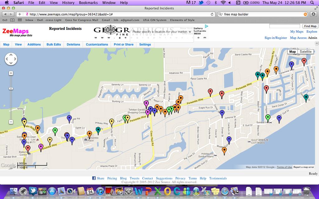
10 Total Incidents Zoomed-In Periwinkle Total Incidents Zoomed-In! 10

11 Crosswalk Incidents Parking Lot Incidents! 11
Crosswalk Policy Revisions & Pedestrian & Bicycle Connection Plans. Presentation to Sanibel City Council July 16, 2013
 Crosswalk Policy Revisions & Pedestrian & Bicycle Connection Plans Presentation to Sanibel City Council July 16, 2013 Outline Crosswalk Policy Revisions Minimum Standards Goals and Objectives Pedestrian
Do As I Say Not As I Do: Observed Compliance vs. Stated Understanding of Pedestrian Crossing Laws in Florida
 Do As I Say Not As I Do: Observed Compliance vs. Stated Understanding of Pedestrian Crossing Laws in Florida Achilleas Kourtellis, Ph.D. July 9, 2015 CUTR Webcast Series Center for Urban Transportation
Southern California Walking/Biking Research And Creative Evaluation
 Southern California Walking/Biking Research And Creative Evaluation Quantitative Research Topline Report December 7, 2015 Background & Objectives The Southern California Association of Governments (SCAG)
Effective Pedestrian & Bicycle Safety Enforcement
 Effective Pedestrian & Bicycle Safety Enforcement August 29, 2013 George Branyan Pedestrian Program Coordinator District Department of Transportation Sgt. Terry Thorne Special Operations Division Metropolitan
FLETCHER AVENUE PEDESTRIAN AND BICYCLIST BEHAVIOR CHANGE FORMATIVE RESEARCH PROJECT
 FLETCHER AVENUE PEDESTRIAN AND BICYCLIST BEHAVIOR CHANGE FORMATIVE RESEARCH PROJECT EXTENT OF CHANGES IN PEDESTRIAN AND BICYCLIST ATTITUDES AND BEHAVIORS DIRECTLY AFTER A COMPLETE STREETS PROJECT IN FLORIDA
TABLE OF CONTENTS. Executive Summary
 Executive Summary Background... ES-1 Pedestrian Network... ES-2 Bikeway Network... ES-2 Collision History... ES-2 Public Input... ES-4 Conclusions and Recommendations... ES-4 1. Introduction and Setting
Prepare the Mock Street Set-Up with masking tape on the floor of the training space.
 Pedestrian Safety 25 minutes Objectives Participants will be able to: understand basic elements of pedestrian safety understand that a police officer s role is to be helpful Materials A hat representing
WalkSafe Vocabulary Matching. 1 pedestrian A marked place to cross the street. 2 intersection A person who is walking. 3 crosswalk. 4 curb.
 WalkSafe Vocabulary Matching Name Directions: Draw a line from the vocabulary word to its definition. 1 pedestrian A marked place to cross the street. 2 intersection A person who is walking. 3 crosswalk
FELL STREET AND MASONIC AVENUE INTERSECTION SURVEY REPORT
 FELL STREET AND MASONIC AVENUE INTERSECTION SURVEY REPORT City and County of San Francisco Municipal Transportation Agency Bicycle Program October 2005 Background The intersection of Fell Street with Masonic
Video Review: Signs, Signals and Markings Video Review 4.1
 Video Review: Signs, Signals and Markings Video Review 4.1 Video 4.1 Review: 1. What must you do before turning left at an intersection with a green light? 2. What do flashing yellow lights mean? 3. At
Pedestrian-Bicycle Emphasis Area Breakout Session. Highway Safety Summit April 26, 2016
 5/20/2016 Pedestrian-Bicycle Emphasis Area Breakout Session Highway Safety Summit April 26, 2016 Fatality and Serious Injury Averages (2008-2013) by Emphasis Area Where We ve Been: February 2014 Highway
Effective Pedestrian & Bicycle Safety Enforcement
 Effective Pedestrian & Bicycle Safety Enforcement October 20, 2011 George Branyan Pedestrian Program Coordinator District Department of Transportation Increasingly multi-modal region Change in Daily Trip
CITY OF SAINT JOHN TRAFFIC CALMING POLICY
 CITY OF SAINT JOHN TRAFFIC CALMING POLICY VERSION: 1.0 April 10, 2012 Pedestrians, Cyclists and Motorists Sharing Street Spaces CONTENTS INTRODUCTION... 3 POLICY GOAL... 3 POLICY OBJECTIVES... 3 GUIDING
Welcome and Introductions Overview of the Study to Date Community Involvement Intersection Improvement Concepts Bike-Ped Recommendations ITS
 Welcome and Introductions Overview of the Study to Date Community Involvement Intersection Improvement Concepts Bike-Ped Recommendations ITS Recommendations Transit Recommendations Next Steps Inventoried
Transportation Issues Poll for New York City
 2016-17 Transportation Issues Poll for New York City 82% support Vision Zero and reducing traffic deaths 72% on average, support more street space for children to play, protected bike lanes and other safety
Getting Your SRTS Project Funded. Ryan Snyder
 Getting Your SRTS Project Funded Ryan Snyder Steps in Submitting a Successful Application 1. Stakeholder outreach: create a SRTS coalition 2. Develop a comprehensive plan and program with all 5 Es 3. Conceive
Bicyclist Signing Guidelines
 Bicyclist Signing Guidelines April, 2009 1 Introduction This paper describes the Montana Department of Transportation s (MDT) current practices related to bicyclist safety and signing issues and presents
The Wiggle Route in Context
 The Wiggle Route in Context In a city of hills, the Wiggle is an important route because it winds its way along the flattest streets from Market to the Panhandle, bringing residents to local parks and
Pine Hills Road Pedestrian/Bicycle Safety Study Board of County Commissioners Work Session
 Pine Hills Road Pedestrian/Bicycle Safety Study Board of County Commissioners Work Session February 20, 2018 Meeting Agenda Study Overview Existing Conditions Access Management Potential Gateway Features
tet c.., I I I TRAFFIC CIRCULATION ELEMENT TASK 3 & 4 - ALTERNATIVES EVALUATION/ FINANCIAL RESOURCES/POLICIES
 tet i- CTY OF SANBEL TRAFFC CRCULATON ELEMENT TASK 3 & 4 - ALTERNATVES EVALUATON/ FNANCAL RESOURCES/POLCES t c.., t Project 17518 May, 1988 Prepared by: David Plummer & Associates, nc. 2267 Main Street
Eliminate on-street parking where it will allow for a dedicated bus only lane %
 Traffic Dashboard Priorities Survey Responses Introduction 1) Are you familiar with bus rapid transit (BRT)? a. No, BRT is new to me. 597 23.5% b. I ve heard of BRT, but I don t know much about it. 1,136
Developing a Safer Cycling Strategy for the ACT ACRS Conference August 2012
 Developing a Safer Cycling Strategy for the ACT ACRS Conference 2012 Peter Strang Canberra Manager Sarah Court Transport Consultant 10 August 2012 Presentation Outline Background Data Analysis (Stage 1)
What if there were no signs, signals or markings?? Throughout Ch 2 you will learn how signs, signals, and markings help regulate traffic flow.
 What if there were no signs, signals or markings?? Throughout Ch 2 you will learn how signs, signals, and markings help regulate traffic flow. Signs, Signals and Road Markings Purpose: To become acquainted
Sistrunk Corridor DOTMOCRACY SUMMARY
 DOTMOCRACY SUMMARY The TOUCH initiative is a true collaborative working with multi- sector community organizations and agencies to reduce tobacco use and exposure to secondhand smoke, improve access to
LAGUNA BEACH POLICE DEPARTMENT MEMORANDUM
 LAGUNA BEACH POLICE DEPARTMENT MEMORANDUM TO: FROM: Christa Johnson, Assistant City Manager Jason C. Kravetz, Captain DATE: January 16, 2015 SUBJECT: Laguna Canyon Road Collision Analysis Within the last
3.1 TRAFFIC CALMING PROCESS SUMMARY
 SECTION 3 3.0 TRAFFIC CALMING 3.1 TRAFFIC CALMING PROCESS SUMMARY Traffic calming is a means in which to reduce speeds and minimize vehicular traffic on local neighborhood streets. Citizen involvement
Controlled. Semi-Controlled PAGE 01 CHAPTER 12 INTERSECTIONS
 PAGE 01 CHAPTER 12 INTERSECTIONS You will cross many intersections while driving. Intersections are especially dangerous because vehicles are crossing each other s driving path. Many crashes happen at
FLORIDA STRATEGIC HIGHWAY SAFETY PLAN
 FLORIDA STRATEGIC HIGHWAY SAFETY PLAN 1 FLORIDA STRATEGIC HIGHWAY SAFETY PLAN Presenter: Joe Santos State Safety Engineer FDOT State Safety Office 2 Presentation 3/28/2017 3 FLORIDA STRATEGIC HIGHWAY SAFETY
Appendix A. Knoxville TPO Greenway Signage Guidelines. Appendix A: Knoxville TPO Greenway Signage Guidelines Knox to Oak Ridge Greenway Master Plan
 Appendix A Knoxville TPO Greenway Signage Guidelines 75 Overview: Adequate signing and marking are essential on shared-use paths, especially to alert bicyclists to potential conflicts and to convey regulatory
Minor Amendments to the Street and Traffic By-law 2849 and Skateboards in Protected Bike Lanes
 ADMINISTRATIVE REPORT Report Date: October 31, 2017 Contact: Lon LaClaire Contact No.: 604.873.7336 RTS No.: 12241 VanRIMS No.: 08-2000-20 Meeting Date: November 15, 2017 TO: FROM: SUBJECT: Standing Committee
NEIGHBORHOOD TRAFFIC CALMING PROGRAM. Policy and Procedure. Roswell Department of Transportation (770)
") NEIGHBORHOOD TRAFFIC CALMING PROGRAM Policy and Procedure Roswell Department of Transportation (770) 594 6420 Approved by M&CC on December 19, 2011 Table of Contents 1. Application and Intent 2. Program
NEIGHBORHOOD TRAFFIC CALMING PROGRAM Policy and Procedure Roswell Department of Transportation (770) 594 6420 Approved by M&CC on December 19, 2011 Table of Contents 1. Application and Intent 2. Program
Appendix C. TRAFFIC CALMING PROGRAM TOOLBOX
 Appendix C. TRAFFIC CALMING PROGRAM TOOLBOX PHASE I...2 Do Not Enter Sign...3 One-Way Sign...4 Turn Prohibition...5 Pavement Markings...6 Speed Monitoring Trailer...7 Neighborhood Speed Watch...8 Police
Downtown Davidson Pedestrian and Bicycle Safety Plan
 Downtown Davidson Pedestrian and Bicycle Safety Plan Enhancement Funds Application Submitted by the Town of Davidson June 2002 Downtown Davidson Pedestrian and Bicycle Safety Plan Project Description At
NJDOT Complete Streets Checklist
 Background The New Jersey Department of Transportation s Complete Streets Policy promotes a comprehensive, integrated, connected multi-modal network by providing connections to bicycling and walking trip
VI-7. TRAFFIC CALMING
 VI-7. TRAFFIC CALMING Calm vehicle traffic to enhance livability and improve safety in all areas of the City. Traffic calming in neighborhoods has been a major focus of the Traffic Division of the Public
Passing Emergency Vehicles and School Speed Zones
 RAA Member Panel Passing Emergency Vehicles and School Speed Zones The State Government is currently reviewing the speed limits in place when passing emergency vehicles with blue and red flashing lights.
SCHOOL CROSSING PROTECTION CRITERIA
 CITY OF MADISON TRAFFIC ENGINEERING SCHOOL CROSSING PROTECTION CRITERIA January 2016 Adopted as Policy on August 31, 1976, by Common Council by Amended Resolution #29,540 Amended on September 14, 1976,
Residential Traffic Calming Program Guide. Town of Ashland, Virginia
 Residential Traffic Calming Program Guide Town of Ashland, Virginia August 1, 2006 TABLE OF CONTENTS A. INTRODUCTION... 1 B. GOALS... 1 C. CRITERIA... 1 D. IDENTIFYING NEIGHBORHOOD TRAFFIC CONCERNS...
Speed Limits Study and Proposal. Public Input Session: 8/14/13
 Speed Limits Study and Proposal Public Input Session: 8/14/13 Why is Decatur a unique place for this project? First Community Transportation Plan in the nation with a Health Impact Assessment. Strong sense
FEDERAL HIGHWAY ADMINISTRATION APPLICATION
 FEDERAL HIGHWAY ADMINISTRATION APPLICATION REQUEST FOR PERMISSION TO EXPERIMENT WITH A BICYCLE BOX INTERSECTION TREATMENT Submitted by: City of Columbus Department of Public Service Date: June 26, 2009
Pine Hills Road Pedestrian/Bicycle Safety Study Community Meeting #1
 Pine Hills Road Pedestrian/Bicycle Safety Study Community Meeting #1 June 8, 2017 Meeting Agenda Study Overview Community Survey Existing Conditions Access Management Potential Safety Countermeasures Potential
San Ramon Elementary School. Travel Plan
 San Ramon Elementary School Travel Plan TABLE OF CONTENTS 1. PURPOSE... 1 1.1. SR2S PLANNING, IMPLEMENTATION AND MONITORING... 1 1.2. MARIN COUNTY MEASURE A... 1 2. SAN RAMON ELEMENTARY SCHOOL PROFILE...
US 41 COMPLETE STREETS CORRIDOR PLANNING STUDY from University Parkway to Whitfield Avenue
 41 US 41 COMPLETE STREETS CORRIDOR PLANNING STUDY from University Parkway to Whitfield Avenue EXECUTIVE SUMMARY DRAFT FEBRUARY 2019 Project Overview The US 41 Complete Streets Corridor Planning Study,
APPENDIX A: Complete Streets Checklist DRAFT NOVEMBER 2016
 APPENDIX A: Complete Streets Checklist DRAFT NOVEMBER 2016 Complete Streets Checklist MetroPlan Orlando s Complete Streets Checklist is an internal planning tool for staff to further implementation of
SAFE ROUTES TO SCHOOL (SR2S)
") SAFE ROUTES TO SCHOOL (SR2S) In partnership with Burbank Unified School District (BUSD) & City of Burbank George Washington Elementary School Thomas Jefferson Elementary School John Muir Middle School
SAFE ROUTES TO SCHOOL (SR2S) In partnership with Burbank Unified School District (BUSD) & City of Burbank George Washington Elementary School Thomas Jefferson Elementary School John Muir Middle School
8. Collisions INTRODUCTION
 8. Collisions INTRODUCTION While traffic collisions can affect anyone, they have a disproportionate impact on bicyclists, who along with pedestrians are the most vulnerable users of the transportation
Why Zone In on Speed Reduction?
 Learn it. Do it. Live it! SPEED REDUCTION IN THE ZONE Why Zone In on Speed Reduction? Speeding is a serious issue that plays a major role in the risk of serious injury and pedestrian fatality in a crash.
Transportation Planning Division
 Transportation Planning Division Presentation Outline Study Tasks Recap of Previous Meeting Stakeholder Interviews Data Collection Design Principles Tool Box Recommendations Schedule Moving Forward North
Traffic Safety Plan Traffic Safety Plan 2015
 Traffic Safety Plan 2015 Purpose Airdrie s last Traffic Safety Plan was created in 2011. The 2015 Traffic Safety Plan is a revised model of the traffic operations for the City of Airdrie. The purpose of
Riverside Drive Complete Streets Project 3 rd Community Meeting. March 26, 2015
 Riverside Drive Complete Streets Project 3 rd Community Meeting March 26, 2015 Providing Feedback Sign-In with contact information for future updates Complete questionnaire provided tonight Complete comment
Halifax Regional Municipality 2016 Heads Up Halifax Post-Campaign Study Final Report
 Halifax Regional Municipality 2016 Heads Up Halifax Post-Campaign Study Final Report March 2017 Prepared for Halifax Regional Municipality by: Background & Objectives The Halifax Regional Municipality
APPENDIX 4 PEDESTRIAN FACILITY DESIGN INFORMATION
 APPENDIX 4 PEDESTRIAN FACILITY DESIGN INFORMATION 96 EXHIBIT 1 97 EXHIBIT 2 Guidelines for Installing Sidewalks Source: Design and Safety of Pedestrian Facilities, Institute of Transportation Engineers,
Implementing the Three Es of School Zone Traffic Calming
 Implementing the Three Es of School Zone Traffic Calming Use this evaluation tool as a guide to analyze the specific safety needs of your school. SCHOOL PROFILE School Name: School District: Address: Phone
Adult School Crossing Guard Guidelines
 The Role of the Adult school crossing guards play an important role in the lives of children who walk or bicycle to school. They help children safely cross the street at key locations. They also remind
TRAFFIC CALMING TOOLBOX. For the residents of the City of Decatur, Georgia
 TRAFFIC CALMING TOOLBOX For the residents of the City of Decatur, Georgia 2 City of Decatur Traffic Calming Toolbox Public Works Department 2635 Talley Street Decatur, GA 30030 404.377.5571 3 Welcome to
BICYCLE RULES OF THE ROAD
 ILLINOIS ILLINOIS ILLINOIS ILLINOIS ILLINOIS ILLINOIS ILLINOIS ILLINOIS BICYCLE RULES OF THE ROAD Jesse White Secretary of State Bicycle riding is a great way to get into shape and enjoy the outdoors.
Presentation Starts at 5:30 PM
 Presentation Starts at 5:30 PM Public Meeting #1 September 22, 2016 Purpose of Study Conceptual Complete Streets Study on South Carson Street 5 th Street to Roland Drive Approximately 2.5 miles Consider
Appendix E: Bike Crash Analysis ( )
") Appendix E: Bike Crash Analysis (2009-2012) Davis Bicycle Crashes Analysis 2009-2012 December 2013 Ride Walk Davis Active Transportation Program City of Davis December 2013 Prepared by: Jimmy Fong Active
Appendix E: Bike Crash Analysis (2009-2012) Davis Bicycle Crashes Analysis 2009-2012 December 2013 Ride Walk Davis Active Transportation Program City of Davis December 2013 Prepared by: Jimmy Fong Active
Microscale Audit of Pedestrian Streetscapes (MAPS), Mini Version
, Mini Version") Microscale Audit of Pedestrian Streetscapes (MAPS), Mini Version Training Manual & Picture Guide Developed by: Carrie Geremia Kelli Cain Revised February 11, 2014 Tool and protocol developed by: James
Microscale Audit of Pedestrian Streetscapes (MAPS), Mini Version Training Manual & Picture Guide Developed by: Carrie Geremia Kelli Cain Revised February 11, 2014 Tool and protocol developed by: James
MEET IN THE STREET MOVING TO ZERO
 WE MEET IN THE STREET MOVING TO ZERO Tips for sharing the street Traffic deaths are preventable. We need your help getting the message out. 2 A NEW PLAN A NEW PLAN Philadelphia is proud to adopt Vision
Watson Chapel School District. School Bus Safety Plan
 Watson Chapel School District School Bus Safety Plan Table of Contents I. Plan Authorization A. Statutory Authority B. Applicable Participants C. Initial Plan and Updates II. School District Responsibilities
AGENDA REPORT. Issue: Discussion of potential improvements on Barnwell Road at Niblick Drive
 AGENDA REPORT To: From: By: Honorable Mayor and City Council Members Warren Hutmacher, City Manager Tom Black, Public Works Director Date: March 23, 2016 Agenda: March 28, 2016 WORK SESSION AGENDA: Barnwell
T I M TEAMT. Collier-Lee-Charlotte County Traffic Incident Management
 30 th Edition T I M TEAMT Collier-Lee-Charlotte County Traffic Incident Management TIMES January 2010 Federal Highway Administration Revises Rules to Make Highways Safer INSIDE THIS ISSUE: FHWA Revises
Pedestrian Safety Campaign
 Pedestrian Safety Campaign 2017-18 Traffic Safety Plan PART OF THE DRIVE FOCUS LIVE TRAFFIC SAFETY PLAN Table of Contents Background. 1 Pedestrian Collision Stats.... 2-3 Goals.. 4 Objectives.. 5 Implementation
Existing Pedestrian Conditions. PSAC February 8, 2011
 Existing Pedestrian Conditions PSAC February 8, 2011 Contents 1. Project Background & Goals 2. Pedestrian Activity: Where people walk 3. Pedestrian Safety: The conditions people face Project Background
CLOSED. Highlights of the Final Concept Design:
 The final Concept Design is the result of many months of listening, learning, creating, balancing, and understanding different needs and viewpoints, as well as incorporating technical requirements and
Pedestrian Safety HANDBOOK
 City & County of San Francisco Department of Public Health Community Health Programs International Institute of San Francisco Immigration & Citizenship Program Find out more about our injury data, community-based
SANTA CLARA COUNTY I-280 CORRIDOR STUDY
 SANTA CLARA COUNTY I-280 CORRIDOR STUDY Appendix D CrowdSpot Outreach Summary SANTA CLARA VALLEY TRANSPORTATION AUTHORITY (VTA) 1-1 Introduction Background I-280 Corridor Study project used Crowdspot mapping
DENVER PUBLIC SCHOOLS DISTRICT DEPARTMENT OF SAFETY
 DENVER PUBLIC SCHOOLS DISTRICT DEPARTMENT OF SAFETY 2018-2019 SCHOOL CROSSING GUARD INFORMATION AND INSTRUCTION MANUAL FOR VOLUNTEER EMPLOYEES SCHOOL CROSSING GUARD INFORMATION AND INSTRUCTION MANUAL The
Strategies. How to Develop a Pedestrian Safety Action Plan Enforcement 6-1
 How to Develop a Pedestrian Safety Action Plan Enforcement Strategies 6-1 Learning Objectives At the end of this module, you should be able to: Describe WHAT and HOW to integrate enforcement strategies
DENTON BIKE AND PEDESTRIAN COUNT VOLUNTEER TRAINING
 DENTON BIKE AND PEDESTRIAN COUNT VOLUNTEER TRAINING WHY ARE WE DOING THIS? Part of the National Bicycle and Pedestrian Documentation Project Direct response to lack of data for non-motorized transportation
Capital Beltway HOT Lanes - Frequently Asked Questions
 Capital Beltway HOT Lanes - Frequently Asked Questions December 20, 2007 1. What is the cost of the project? The fixed-price design-build cost is approximately $1.4 billion. 2. Why have the project costs
Committed to Service
 Committed to Service Paul Woods, President Rebecca W. Arnold, Vice President Sara M. Baker, Commissioner Jim D. Hansen, Commissioner Kent Goldthorpe, Commissioner March 14, 2017 Planning and Programming
PROJECT OVERVIEW & WORK COMPLETED
 CR/SR A1A PEDESTRIAN SAFETY & MOBILITY STUDY RIVER TO SEA TRANSPORTATION PLANNING ORGANIZATION TPO Board Meeting April 27, 2016 PROJECT OVERVIEW & WORK COMPLETED 1 Project Overview Study Limits Bethune
Improvements Infrastructure Gap Assessment and Improvements Street Striping
 Infrastructure Project Proposal The federal-aid Safe Routes to School program funds infrastructure/engineering projects that fall into two categories: Design (available only to School Development Authority
Unit Six: Driving Faster with More Risk URBAN, SUBURBAN, AND RURAL DRIVING
 Unit Six: Driving Faster with More Risk URBAN, SUBURBAN, AND RURAL DRIVING What Is The Impact Of Distraction? Objectives For Unit Six Students will be able to describe the skills necessary to What safely
RM 620 FEASIBILITY STUDY
 RM 620 FEASIBILITY STUDY Sections 5 & 6 December 7, 2015 STUDY PROCESS Study Purpose and Goals The RM 620 Feasibility Study was launched by the Texas Department of Transportation (TxDOT) to analyze transportation
Student Pedestrian Safety Fiddlers Canyon Elementary Community Council 2012
 Student Pedestrian Safety Fiddlers Canyon Elementary Community Council 2012 Introduction Fiddlers Canyon Elementary students must cross North Wedgewood Lane and Fiddlers Canyon Drive in order to come to
NM-POLICY 1: Improve service levels, participation, and options for non-motorized transportation modes throughout the County.
 Transportation PRINCE WILLIAM COUNTY 2008 COMPREHENSIVE PLAN NON-MOTORIZED PLAN CONTENTS Goals, Policies, and Action Strategies Table 4 (Bike Facility Classifications and Descriptions) Table 5 (Bike Facility
GUIDELINES FOR EMERGENCY TRAFFIC CONTROL
 GUIDELINES FOR EMERGENCY TRAFFIC CONTROL TABLE OF Contents Page Introduction...1 Chapter 6I of the 2009 MUTCD...2 Reason for Control...6 Components of Incident Management Area...7 Traffic Control Devices
ORANGE COUNTY SHERIFF S OFFICE Traffic Section. Crash Data Analytics Vehicle vs Pedestrian/Cyclist For the INTERNATIONAL DRIVE DISTRICT
 ORANGE COUNTY SHERIFF S OFFICE Traffic Section Crash Data Analytics Vehicle vs Pedestrian/Cyclist For the INTERNATIONAL DRIVE DISTRICT Selected Data Criteria: DATE Range: 2 ½ years January 01, 2015 July
Fiscal Year 2017 Bicycle and Pedestrian Metric Report
 Fiscal Year 2017 Bicycle and Pedestrian Metric Report November 2017 In 2015, the Virginia Department of Transportation s (VDOT) implementation of the 2004 Commonwealth Transportation Board s (CTB) Policy
This page intentionally left blank.
 This page intentionally left blank. COMMUNITY Glenpool Community Overview Glenpool Glenpool is a city of nearly 12,000 residents located in Tulsa County southwest of Tulsa and Jenks. The city is growing
Evaluation of Pedestrian and Cyclist Warning Systems for Trucks
 ROAD SAFETY AND MOTOR VEHICLE REGULATIONS Evaluation of Pedestrian and Cyclist Warning Systems for Trucks Peter Burns, peter.burns@tc.gc.ca June 20, 2018 Outline Background and updated collision data Track
West Capitol Avenue Road Rehabilitation and Safety Enhancement Project
 West Capitol Avenue Road Rehabilitation and Safety Enhancement Project Stakeholder Focus Group Meeting #2 Tuesday, August 28, 2018 7:00 8:00 a.m. West Sacramento City Hall 1110 West Capitol Avenue, West
and older adults and people with disabilities still face barriers when using the pedestrian network and public transportation.
 Background Afterthe1980Olympics,theLakePlacid/NorthElbacommunityadoptedaneconomicstrategy ofdevelopingandmarketingeventstoincreaseareatourism.thisstrategyhasbeenvery successful.overrecentyearsthevolumeofvisitorshasincreased,andthelengthofthe
About the Studio. Edward J. Bloustein School of Planning and Public Policy - Rutgers University
 About the Studio Edward J. Bloustein School of Planning and Public Policy - Rutgers University Purpose of studio: Help City of Bayonne apply for Safe Routes to School (SRTS) funding by producing a School
Scope: Stakeholder and Staff Training Bicycle and Pedestrian Crash Data Analysis Stakeholder and Public Workshops Development of Infrastructure,
 Scope: Stakeholder and Staff Training Bicycle and Pedestrian Crash Data Analysis Stakeholder and Public Workshops Development of Infrastructure, Outreach and Coordination Strategies Documentation and Presentations
Proposed Bicycle Ambassador Program. Transportation Enhancement Funding Application
 Proposed Bicycle Ambassador Program Transportation Enhancement Funding Application 1 Alternative Transportation Goals Resolution 944 By 2012, as a community, increase the percentage of residents walking,
V2X Bicycle and Pedestrian Detection. ITS Wisconsin Annual Conference October 23, 2018
 V2X Bicycle and Pedestrian Detection ITS Wisconsin Annual Conference October 23, 2018 Adam Lyons Iteris, Inc. Denver, CO Adam Lyons Iteris, Inc. Denver, CO WisDOT Funded Bike/Ped Projects 1993 2014 ~700
INCREASING SCHOOL-YEAR ROAD SAFETY: PROVEN STRATEGIES YOU CAN USE NOW
 INCREASING SCHOOL-YEAR ROAD SAFETY: PROVEN STRATEGIES YOU CAN USE NOW Presenter Cam Reed Territory Manager All Traffic Solutions ABOUT CAM REED Cam spent 15 years in law enforcement, most of those years
Road Improvement Consultations Huntingdon Road
 Road Improvement Consultations Huntingdon Road General Summary: About You In total, 828 people responded to this consultation. 33.1% indicated they were a resident of Girton. 18.6% stated they were a resident
Parental Responsibilities
 Bicycle riding is a fun way to exercise and enjoy the outdoors. To remain safe on Illinois roads, bicyclists must obey the same traffic safety laws that govern vehicle drivers. No amount of bicycle safety
Traffic Signs and Signals
 CHAPTER FOUR Traffic Signs and Signals Traffic signs control traffic flow, making streets and highways safer for drivers, bicyclists and pedestrians. These signs, which are posted by the Indiana Department
Captain Cook Elementary. Action Details Start Complete Notes
 City of Vancouver Complete School Travel Plan Report Crosswalk improvements on E 55 th Avenue Track progress and collect all relevant ATP information into a School Travel Plan submitted to Captain Cook,
Emergency Response Support Signage on Multi-Use Trails Plan
 DRAFT ( ) Emergency Response Support Signage on Multi-Use Trails Plan Prepared for: SATS Multi-Use Trails Jurisdictions Committee Table of Contents Introduction... 3 Mileage Markers... 4 Rest Stop Identifiers...
APPENDIX D. May 22, 2002 Open House Summary and Materials
 APPENDIX D May 22, 2002 Open House Summary and Materials TH 36 Partnership Study Open House May 22, 2002 Summary of Survey Responses 1. If no new crossing of the St. Croix River is built (e.g. the existing
WEST CAMPUS COGENERATION FACILITY CONSTRUCTION TRAFFIC PLAN. Madison, Wisconsin 53726
 WEST CAMPUS COGENERATION FACILITY CONSTRUCTION TRAFFIC PLAN The West Campus Cogeneration Facility (WCCF) Construction Traffic Plan covers work associated with the WCCF project. This work includes: WCCF
CONTENTS EXECUTIVE SUMMARY 1
 CONTENTS CHAPTER PAGE EXECUTIVE SUMMARY 1 1 ISSUES AND PURPOSE OF THE ANALYSIS 2 1.1 Background 2 1.2 Analysis Area 2 1.3 Issues and Observations 3 1.4 Project and Public Meetings 3 2 LIST OF PREFERRED
Coeur d Alene Police Submitted by: Crime Analysis 3818 Schreiber Way, Coeur d Alene, ID June 14, 2017
 Monthly Crime Report May 2017 Coeur d Alene Police Submitted by: Crime Analysis 3818 Schreiber Way, Coeur d Alene, ID 83815 June 14, 2017 May Crime Report 2017 PURPOSE: The purpose of this report is to