James Telford Brantford, Ontario Grew up on the Grand River and Great Lakes, Southern Ontario. Brother. Graduate Student Researcher Wapusk National
|
|
|
- Karin Clarke
- 6 years ago
- Views:
Transcription


1 James Telford Brantford, Ontario Grew up on the Grand River and Great Lakes, Southern Ontario. Brother. Graduate Student Researcher Wapusk National Park, Manitoba Peace-Athabasca Delta, Alberta Marian Watershed, Tłı cho Lands, NWT. Academic Partner on Marian Watershed Stewardship Program

2 Establishing a metals and hydroecologic baseline to support the Marian Watershed Stewardship Program James Telford MSc Candidate Brent Wolfe - Wilfrid Laurier University Roland Hall - University of Waterloo Sjoerd van der Wielen Tłı cho Government, Lands Protection Department


3 Concerns Climate Change Lower water levels Less Snow, Higher Temperatures More forest fires? Metals Pollution Pollution from mining and industry Mining begins in 1933 Ray Rock mine Giant/Con Mine Future NICO mine? How do we track pollution from mines? Atmospheric transport, through the air. River Transport.


4 Natural Sources of Metals Catchment Erosion Forest Fires can cause rapid erosion Bedrock Weathering

5 Objectives Establish a baseline of sediment metals concentrations from sediment cores at various locations, which can then be used for continued monitoring of surface sediment concentrations to identify potential pollution. Track long term changes in hydroecological conditions to identify natural changes and those changes, which are a result of climate warming Give context to current observation of low water levels.
6 2016 Water Sampling Water- Very low metals, except Al, likely natural Total Metals (Water) mg/l Aluminum (Al) Arsenic (As) Chromium (Cr) Iron (Fe) Lead (Pb) Mercury (Hg) Uranium CCME FAL /15 Marian < < Marian < Marian < Marian < Marian < Marian < < Marian < Marian < < Marian < < Marian < < Marian < Marian < < Marian < Le Martre < < Le Martre <
7 2016 Sediment Sampling Minor elevation in Arsenic, Chromium, Copper, Zinc Natural, Geogenic vs anthropogenic? Metals (Soil) mg/kg Aluminum Arsenic Cadmium Chromium Copper Iron Lead Manganese Mercury Uranium Zinc ISQG/PEL 5.9/17 0.6/ / /197 35/ / Marian Marian Marian Marian Marian Marian Marian Marian Marian Marian Marian Marian / Le Martre Le Martre

8 What is a Baseline? Need something to compare contemporary data to. There is an absence of long term records. What was the environment like before mining and climate change? Need to separate the natural variations from industrial activities. Mining began in 1933, therefor our baseline is pre-1933


9 Tondu 2012 Paleolimnology Lake History Sediment Cores Establish long-term records of environmental history from the watershed. Sediment material comes into the lake from the land, from streams and from the air, accumulating over time. Youngest Metals Oldest


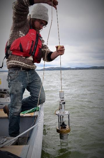

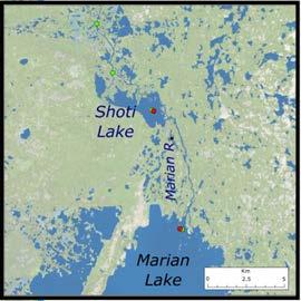
10 Sediment Cores Sediment cores have been collected from 8 lakes throughout the Marian Watershed in 2015 and 2016.


11 Initial Sediment Core Results Nico Lake , Signing of the Tlicho Agreement 1921 Chief Monfwi Signs Treaty Canada Confederation Located beside the NICO deposit. Naturally high in metals. Very little stream inflow. Higher elevation. 2 Sediment Cores ~ ~500+ year record 1763 Royal Proclamation ~1700 ~1600 ~1498

12 Nico Lake Metals Baselines Established, Sediment Chromium Concentration ug/g 2020 Sediment Chromium Normalized to Lithium 2020 Sediment Copper Concentration ug/g 2020 Sediment Copper Normalized to Li Cr Pre-1933 Baseline Cr/Li Pre-1933 Baseline Cu Pre-1933 Baseline Cu/Li Pre-1933 Baseline ug/g Metals concentrations are normalized to lithium to distinguishing natural sources from pollution. ug/g
13 Sediment Arsenic Concentration ug/g Arsenic Normalized to Lithium Sediment Cores: Initial Metals Results from Nico Lake As Pre-1933 Baseline 112ug/g As/Li As/Li Basline Major increase at 1948 corresponding to Giant Mine operation ~185km SE Decrease in early 60s with pollution controls. Potential for metals pollution runoff from the surrounding land. Major decline late 90s early 2000 s corresponding to end of Giant, Con mines ug/g
14 100+ Years of Monitoring Data 1.8 Temporal Trends in Normalized Arsenic to Statistical Baseline COV Enrichment Factor Pre-1933 Baseline Pollution (COV) Lower COV Normalized Arsenic Value Date Powerful tool for continued monitoring.

15 Conclusion Paleolimnological methods provide means to establish metals concentrations baselines. Identifies evidence of arsenic pollution during latter half of 20 th century. Next Steps Establish metals concentrations baselines for Shoti or Marian Lake to compare to contemporary sediment data for use in monitoring downstream locations. Continue with geochemical and biological analysis to assess the influence of climate change on recent observations of lake levels. Incorporate results to Tłı cho Government monitoring initiatives.


16 Masi Cho!
17 Sediment Fe Concentration ug/g Sediment Fe Normalized to Li and Al 0.0 OM Year (CRS Model) Year (CRS Model) Nico C1 Nico C Fe Pre 1933 Baseline Fe/Li Pres 33 Baseline
18 As to Li R² = Surface sediment from M!to M13
Flambeau River Monitoring at the Flambeau Mine Rusk County, Wisconsin
 1 Flambeau River Monitoring at the Flambeau Mine Rusk County, Wisconsin 4. WALLEYE TISSUE MONITORING Analysis, Comments and Recommendations prepared for Wisconsin Resources Protection Council Dr. Ken Parejko
NC DIVISION OF WATER RESOURCES (NCDWR) THIRD ROUND OF DAN RIVER FISH TISSUE METALS FOLLOWING
 THIRD ROUND OF DAN RIVER FISH TISSUE METALS FOLLOWING") NC DIVISION OF WATER RESOURCES (NCDWR) THIRD ROUND OF DAN RIVER FISH TISSUE METALS FOLLOWING THE EDEN COAL ASH SPILL (10 MONTH POST-SPILL ASSESSMENT), MAY 18, 2015. Key Findings Results for the NCDWR s
NC DIVISION OF WATER RESOURCES (NCDWR) THIRD ROUND OF DAN RIVER FISH TISSUE METALS FOLLOWING THE EDEN COAL ASH SPILL (10 MONTH POST-SPILL ASSESSMENT), MAY 18, 2015. Key Findings Results for the NCDWR s
APPENDIX A: Sources of Pollutants in Urban Areas.
 APPENDIX A: Sources of Pollutants in Urban Areas. Robert Pitt, Roger Bannerman, Shirley Clark and Derek Williamson Oversize tables from Chapters 23 and 24. 507 508 Oversize table from Chapter 23. Table
Climate Change and Hydrology in the Sierra Nevada. Lorrie Flint U.S. Geological Survey Sacramento CA
 Climate Change and Hydrology in the Sierra Nevada Lorrie Flint U.S. Geological Survey Sacramento CA Discussion Topics Climate change for California Methods to evaluate hydrologic impacts Water balance
RAMP Objectives. RAMP Studies
 2008 Monitoring Results Fort Chipewyan, June 9, 2009 Presented by: Fred Kuzmic Wade Gibbons Martin Davies Heather Keith Hatfield Consultants. All Rights Reserved. 8/12/2009 SLIDE 1 What is RAMP? Initiated
Manitoba Water Stewardship. Coping with Drought. Drought Research Initiative Workshop. Inn at the Forks, Winnipeg. A.A. Warkentin. January 11-13, 2007
 Manitoba Water Stewardship Coping with Drought Drought Research Initiative Workshop Inn at the Forks, Winnipeg A.A. Warkentin January 11-13, 2007 Annual Renewal of Water Supplies Important Precipitation-based
1.Mill Creek Watershed Summary Description and Land Use
 1.Mill Creek Watershed Summary Description and Land Use Table xxx: Mill Creek Watershed Overview Watershed Size 31,435 acres/49.1 sq miles/ 127.1 sq km Elevation Range 5,594 feet [4,967-10,561] Stream
Test Report. No.: EM CE003 Date:Sep.22,2016 Page 1 of 9. : Sep.21,2016 ~ Sep.22,2016
 No.: EM160921023CE003 Date:Sep.22,2016 Page 1 of 9 Applicant Address : CNEX AIE SL : C/ Mendez Nuñez,4908302 Mataró - Barcelona Spain Sample Name Model Labeled Age Grading : Massager : 30014(main test),20537,20519,20529,20469
First Nations Fish Habitat Program Discussion Workbook
 First Nations Fish Habitat Program Discussion Workbook The First Nations Fish Habitat Program is a joint initiative of the Centre for Indigenous Environmental Resources (CIER) and The Southern Chiefs Organization
NRCan Exploration & Deposit Appraisal Statistics for Northern Canada
 NRCan Exploration & Deposit Appraisal Statistics for Northern Canada NRCan Data as of February 2018 is sourced here: http://sead.nrcan.gc.ca/expl-expl/annual-eng.aspx Northern Canada Mineral Exploration
Fish were collected in April September 2013 by the Fisheries and Wildlife Division staff at DOEE.
 Fish were collected in April September 2013 by the Fisheries and Wildlife Division staff at DOEE. US EPA Guidance for Assessing Chemical Contaminant Data for Use in Fish Advisories Volume 1: Fish Sampling
Allegheny River Stewardship Project
 Allegheny River Stewardship Project Volunteer Newsletter Volume Issue 4 August 008 www.chec.pitt.edu chec@pitt.edu PARTNERS Alle-Kiski Health Foundation Rachel Carson Homestead RiverQuest Venture Outdoors
Name: Date: Day/Period: CGC1P1: Interactions in the Physical Environment. Factors that Affect Climate
 Name: Date: Day/Period: CGC1P1: Interactions in the Physical Environment PART A: Weather and Climate Factors that Affect Climate 1. The words weather and climate are often incorrectly used interchangeably.
@farmtested. Research and Evaluation Results
 @farmtested Research and Evaluation Results W olf Trax Innovative Micronutrients Table of Contents The Wolf Trax approach to research 2 When you correct a deficiency, you unlock yield potential 5 Wolf
APPENDIX A PHOTOGRAPHIC SUMMARY. RAINY RIVER PROJECT Final Environmental Assessment Report
 APPENDIX A PHOTOGRAPHIC SUMMARY RAINY RIVER PROJECT APPENDIX A: PHOTOGRAPHIC SUMMARY LIST OF PHOTOGRAPHS PAGE Plate 1: (RRP) core processing facility... 1 Plate 2: Typical exploration drilling operations...
Canada s Natural Systems. Canadian Geography 1202
 Canada s Natural Systems Canadian Geography 1202 Canada s Natural Systems Natural System: A system found in nature Here are the four natural systems that we will explore in the next few weeks 1. Canada
Do upstream mining activities alter fish communities beyond a reference condition defined for the South Nahanni River and Nahanni National Park?
 Do upstream mining activities alter fish communities beyond a reference condition defined for the South Nahanni River and Nahanni National Park? David West 1, Paula Spencer 1,2, Troy Searson 2, Monique
Hydrological Condition Report including the issues of High Flow Fluctuation in Chiang Saen
 Hydrological Condition Report including the issues of High Flow Fluctuation in Chiang Saen Technical Symposium for ESCIR and MRC on Social Impact Assessment in River Basin Management Sothea KHEM, HENG
Seawater. Earth is an Ocean Planet
 Seawater Earth is an Ocean Planet Topics Origin of the Ocean and Atmosphere Hydrologic Cycle Biogeochemical Cycle Seawater Salinity Variations in Seawater Chemistry Carbonic Acid System Topics Origin of
Table xxx: Listed and Suspected Impairments for Willow Creek 2010 Reach Impairment Pollutant Impaired Uses
 1. (Fairmont) Watershed Summary Description and Land Use Table xxx: (Fairmont) Watershed Overview Watershed Size 18,331 acres/28.7 sq miles/74.3 sq km Elevation Range 2,615 feet [4,980-7,595] Stream Miles
Climate change impacts on water availability in three Mediterranean watersheds of Catalonia (NE Spain) Diana Pascual, Eduard Pla (CREAF)
 Diana Pascual, Eduard Pla (CREAF)") Climate change impacts on water availability in three Mediterranean watersheds of Catalonia (NE Spain) Diana Pascual, Eduard Pla (CREAF) 2011 International SWAT Conference INDEX 1.The project 2.Background
Climate change impacts on water availability in three Mediterranean watersheds of Catalonia (NE Spain) Diana Pascual, Eduard Pla (CREAF) 2011 International SWAT Conference INDEX 1.The project 2.Background
An Educator s Guide to Wild Caribou of North America. Case Study: Bathurst Herd
 An Educator s Guide to Wild Caribou of North America Case Study: Bathurst Herd Copyright 2018 This book may be reproduced for educational purposes only. The illustrations may be duplicated solely for instructional
Richards Bay Coal Terminal
 Text Leon Goussard Manager Port Infrastructure Transnet National Ports Authority Port of Richards Bay leon.goussard@transnet.net Railway and harbour engineering New berth 306 expands capacity of Richards
Chemical and Biological Recovery from Acidic Deposition in the Honnedaga Lake Watershed
 Chemical and Biological Recovery from Acidic Deposition in the Honnedaga Lake Watershed Abstract Honnedaga Lake supports one of seven remaining heritage strains of brook trout designated by the State of
TROUT CREEK WATERSHED (Second Year of Snowline Data)
") Extent of Snow Cover During the 2002 Spring Freshet For the TROUT CREEK WATERSHED (Second Year of Snowline Data) (Penticton Forest District) 1.0 INTRODUCTION The extent of snow cover over a watershed basin
Extent of Snow Cover During the 2002 Spring Freshet For the TROUT CREEK WATERSHED (Second Year of Snowline Data) (Penticton Forest District) 1.0 INTRODUCTION The extent of snow cover over a watershed basin
Mecklenburg County. Fish Consumption Advisories A Local Government Perspective
 Mecklenburg County Fish Consumption Advisories A Local Government Perspective David Caldwell Charlotte-Mecklenburg Storm Water Services Water Quality Program NCLMS October 4, 2012 Lake monitoring program
Eastern Brook Trout Joint Venture. Update
 Eastern Brook Trout Joint Venture (EBTJV) Update Mark Hudy USDA Forest Service, Fish and Aquatic Ecology Unit NFHAB Board Meeting April 17, 2012 Introduction Assessment Case History 1. Evaluate the distribution
2013/14. Annual Report
 2013/14 Annual Report Who we are The Northwest Territories Cumulative Impact Monitoring Program (NWT CIMP) is a source of cumulative environmental impact information for decision-makers and communities
Sustaining the Raritan River Watershed
 Sustaining the Raritan River Watershed 8 th Annual Sustainable Raritan River Conference June 10, 2016 Rick Lathrop Department of Ecology, Evolution & Natural Resources Rutgers School of Environmental and
MBMG Butte Mine Flooding Monthly Report BMFOU Consent Decree BU-SEH Remedial Action Monitoring Program Contract No TO-35 September 2013
 MBMG Monthly Report BMFOU Consent Decree 02-35-BU-SEH Remedial Action Monitoring Program Contract No. 400022-TO-35 September 20 The Montana Bureau of Mines and Geology (MBMG) continued to perform monitoring
Steelhead natal source inferences using otolith microchemistry
 Steelhead natal source inferences using otolith microchemistry Carson G. Prichard 1, Nicole M. Watson 1, Kevin L. Pangle 1, Jory L. Jonas 2, James J. Student 3 1 Central Michigan University, Department
Real Time Water Quality Report Main River at Paradise Pool
 Real Time Water Quality Report Main River at Paradise Pool Deployment Period 2010-08-24 to 2010-11-03 2011-01-05 Government of Newfoundland & Labrador Department of Environment and Conservation Water Resources
Jason Blackburn, Paul Hvenegaard, Dave Jackson, Tyler Johns, Chad Judd, Scott Seward and Juanna Thompson
 Alberta Conservation Association (ACA) Date: 2014-2015 Project Name: Owl River Walleye and Aquatic Habitat Assessment Fisheries Program Manager: Peter Aku Project Leader: Tyler Johns Primary ACA staff
EVALUATING THE EFFECTS OF BIVALVE SHELLFISH AQUACULTURE AND ITS ECOLOGICAL ROLE IN THE ESTUARINE ENVIRONMENT IN THE UNITED STATES
 EVALUATING THE EFFECTS OF BIVALVE SHELLFISH AQUACULTURE AND ITS ECOLOGICAL ROLE IN THE ESTUARINE ENVIRONMENT IN THE UNITED STATES Brett Dumbauld USDA Agricultural Research Service, Hatfield Marine Science
Trust in Canada: Its evolution through time, space and age groups
 Trust in Canada: Its evolution through time, space and age groups Presented by Isabelle Valois, Département de sociologie, Université de Montréal, at the 2010 Annual Conference of the Canadian Sociological
Drinking-Water Systems Regulation O. Reg. 170/03
 2017 ANNUAL REPORT FOR WATER WORKS (R. 170/03, Sec. 11) Drinking-Water System Number: 220008523 Drinking-Water System Name: Island Lake Drinking Water System Drinking-Water System Owner: The Corporation
Temperature Profiling Within the Trout Creek Sub-Watershed 2013 Prepared by the Kennebecasis Watershed Restoration Committee January 2014
 Temperature Profiling Within the Trout Creek Sub-Watershed 2013 Prepared by the Kennebecasis Watershed Restoration Committee January 2014 A partnership project between the KWRC and Agriculture and Agri-Foods
Know Your River Conwy Salmon & Sea Trout Catchment Summary
 Know Your River Conwy Salmon & Sea Trout Catchment Summary Introduction This report describes the status of the salmon and sea trout populations in the Conwy catchment. Bringing together data from rod
HEAVY METALS IN SUSPENDED SEDIMENTS IN RIVERS FLOWING THROUGH MEGACITIES IN SOUTHEAST ASIA
 HEAVY METALS IN SUSPEED SEDIMENTS IN RIVERS FLOWING THROUGH MEGACITIES IN SOUTHEAST ASIA Chihiro Yoshimura, Chikako Yamanaka 2, Manabu Fujii 3, Suchat Leungprasert 4, Maria Antonia N. Tanchuling 5 Tokyo
PRELIMINARY ASSESSMENT OF FISH IN MELIAU RIVER, ULU TUNGUD, SABAH. by Azli Abu Bakar & David Lee Global Environment Centre
 PRELIMINARY ASSESSMENT OF FISH IN MELIAU RIVER, ULU TUNGUD, SABAH by Azli Abu Bakar & David Lee Global Environment Centre OBJECTIVES To assess fish species diversity and distribution of Meliau river To
N ORTHWEST T ERRITORY M ÉTIS N ATION Box 720 Fort Smith, NT Canada X0E 0P0. 1. An Overview of the NWTMN Historical Context
 1. An Overview of the NWTMN Historical Context The Northwest Territory Métis Nation (NWTMN) is comprised of the Indigenous Métis from the South Slave region in the Northwest Territories. The NWTMN is comprised
TRANSPORTATION TOMORROW SURVEY
 Clause No. 15 in Report No. 7 of was adopted, without amendment, by the Council of The Regional Municipality of York at its meeting held on April 17, 2014. 15 2011 TRANSPORTATION TOMORROW SURVEY recommends
GNWT Responses to WRRB September 8 th TASR Questions. Topic: Fisheries Yield & Harvest Pressure Question 1
 s to WRRB September 8 th TASR Questions Topic: Fisheries Yield & Harvest Pressure Question 1 In the Adequacy Statement, walleye is identified as a species present in Lac La Martre. Is there a yield model
FISHERIES BLUE MOUNTAINS ADAPTATION PARTNERSHIP
 FISHERIES A warming climate, by itself, substantially affects the hydrology of watersheds in the Blue Mountains. Among the key hydrologic changes projected under all scenarios for the 2040s and beyond
1.Warm Springs Creek (Anaconda) Watershed Description and Land Use
 Watershed Description and Land Use") 1.Warm Springs (Anaconda) Watershed Description and Land Use Table xxx: Warm Springs Watershed Overview Watershed Size 92,288 acres/144.2 sq miles/373.6 sq km Elevation Range 5,781 feet [4,800-10,581]
1.Warm Springs (Anaconda) Watershed Description and Land Use Table xxx: Warm Springs Watershed Overview Watershed Size 92,288 acres/144.2 sq miles/373.6 sq km Elevation Range 5,781 feet [4,800-10,581]
SECTION 2 HYDROLOGY AND FLOW REGIMES
 SECTION 2 HYDROLOGY AND FLOW REGIMES In this section historical streamflow data from permanent USGS gaging stations will be presented and discussed to document long-term flow regime trends within the Cache-Bayou
Chapter 1: Introduction
 Chapter 1: Introduction 1.0 The Report Card 1.0.1 Background People are becoming more aware of environmental issues locally and globally and want to know what they can do to improve their local watersheds.
The Beverly Caribou Herd Continental Wilderness Travelers by Leslie Wakelyn
 The Beverly Caribou Herd Continental Wilderness Travelers by Leslie Wakelyn Range location and use: November 1999 Beverly caribou have migrated across the northern Canadian landscape for thousands of years,
Notice of Intent to Prepare an Environmental Impact Statement and Management
 This document is scheduled to be published in the Federal Register on 07/10/2015 and available online at http://federalregister.gov/a/2015-16851, and on FDsys.gov 4310-MA DEPARTMENT OF THE INTERIOR National
Today: Coastal Issues and Estuaries
 Today: Coastal Issues and Estuaries Coastal issues Human effect on coastlines What is an estuary Why are they so important? Circulation of water in estuary Environmental issues Coastal Issues: Problem
The Composition of Seawater
 The Composition of Seawater Salinity Salinity is the total amount of solid material dissolved in water. Most of the salt in seawater is sodium chloride, common table salt. Element Percent Element Percent
Morphological change on Cua Dai Beach, Vietnam: Part I image analysis
 Morphological change on Cua Dai Beach, Vietnam: Part I image analysis Nguyen Trung Viet 1, Vo Cong Hoang 2,3 and Hitoshi Tanaka 4 Abstract Severe erosion has been occurred on Cua Dai Beach, Hoi An City,
Example Applications
 Example Applications The following example applications are intended to present how the tools developed for Trout Unlimited s Brook Trout Conservation Portfolio and Range-wide Assessment of Habitat Condition
MEXICAN MINING INDUSTRY RECENT DEVELOPMENT. Toronto, Canada March, 2016
 MEXICAN MINING INDUSTRY RECENT DEVELOPMENT Toronto, Canada March, 2016 1. Mexican Mining Industry 2015 2. Mineral Market Outlook 3. Mexican Mining Advantages 4. Mexican Mining Competitiveness 2 MEXICAN
EPA/625/R - 92 /013/Appendix D
 EPA/625/R - 92 /013/Appendix D EPA/625/r - 92 /013 Appendix F Appendix D: Sample Results and Agronomic Rate Calculation Appendix E: Public Notification Documents Letter to Neighbors Dear
CATCHMENT HYDROLOGICAL RESPONSE TO CHANGING LAND SYSTEM IN KASHMIR HIMALAYA
 IGC, 2012 28 August, 2012 CATCHMENT HYDROLOGICAL RESPONSE TO CHANGING LAND SYSTEM IN KASHMIR HIMALAYA Prof. SHAKIL A ROMSHOO HEAD, DEPT OF EARTH SCIENCES KASHMIR UNIVERSITY PRESENTATION OVERVIEW KASHMIR
The NWT economy is in decline The mineral industry is key to its revival
 Note: Several additional slides have been appended following the presentation to provide Councillors with additional information to help respond to some of their questions. The NWT economy is in decline
Physical Geography. Physical Geography III of the United States and Canada. Formation of Great Lakes. Climates of North America. Definitions 2/21/2013
 Physical Geography III of the United States and Canada Ancient Glacial Lakes As the Ice Age ended, areas of North America beyond the terminal moraine were flooded with melt water Prof Anthony Grande AFG
Modelling Near-Surface Processes
 Modelling Near-Surface Processes Katherine Romanak, Changbing Yang, JP Nicot The University of Texas at Austin Bureau of Economic Geology Gulf Coast Carbon Center DOE, 1999 IEAGHG 2nd Combined Meeting
THE UC DAVIS BIOSENTINEL MERCURY MONITORING PROGRAM: Feedback Tool for Watershed Management
 THE UC DAVIS BIOSENTINEL MERCURY MONITORING PROGRAM: Feedback Tool for Watershed Management Darell G. Slotton Shaun M. Ayers Ronald D. Weyand Department of Environmental Science and Policy University of
Lake Shoreline Habitat and Bathymetry
 Lake Shoreline Habitat and Bathymetry May 2011 181 Bathymetry of the bay is provided in Figure 2.8-23. The maximum depth to the limits of the survey was 24 m. The drop-off from the shoreline is relatively
Assessment of Baseline Geomorphic Features at. Proposed Stream Crossings On The Proposed County Road 595. Marquette County, Michigan
 Assessment of Baseline Geomorphic Features at Proposed Stream Crossings On The Proposed County Road 595 Marquette County, Michigan Prepared for: Kennecott Eagle Minerals Company Marquette, Michigan Prepared
Joe Rathbun Michigan DEQ Water Resources Division Nonpoint Source Unit * Thanks to The Nature Conservancy
 Joe Rathbun Michigan DEQ Water Resources Division Nonpoint Source Unit rathbunj@mi.gov * Thanks to The Nature Conservancy Road-stream intersections = 67,511 Culverts = 60,700 Bridges = 6,811 Perched Piping
Population Ecology Yellowstone Elk by C. John Graves
 Population Ecology Yellowstone Elk by C. John Graves Group Names: Hour Date: Date Assignment is due: end of class Score: + - Day of Week Date Rocky Mountain elk (Cervus elaphus) living in Yellowstone National
ST LEONARDS COASTAL HAZARD VULNERABILITY ASSESSMENT
 Level 12, 333 Collins Street Melbourne VIC 3000 Australia Telephone: +61 3 8676 3500 Facsimile: +61 3 8676 3505 www.worleyparsons.com WorleyParsons Services Pty Ltd ABN 61 001 279 812 23 November 2011
Five Ways the 2016 Census Affects Marketers
 Five Ways the 2016 Census Affects Marketers February 15, 2018 Dr. Doug Norris Senior Vice President and Chief Demographer Rupen Seoni Senior Vice President and Practice Leader Today s presenters Dr. Doug
APPENDIX 2.1 Lake Sturgeon - Mitigation and Enhancement
 APPENDIX 2.1 Lake Sturgeon - Mitigation and This page is intentionally left blank. Lake Sturgeon Mitigation and As a provincial crown corporation providing electric energy and natural gas service, Manitoba
Aspects and Case Studies of the Effects of Climate Change on Water Resources. Part II (Case Studies)
") Aspects and Case Studies of the Effects of Climate Change on Water Resources Part II (Case Studies) Manfred Koch Department of Geohydraulics and Engineering Hydrology, University of Kassel, Germany Email:
Aspects and Case Studies of the Effects of Climate Change on Water Resources Part II (Case Studies) Manfred Koch Department of Geohydraulics and Engineering Hydrology, University of Kassel, Germany Email:
Water stage dynamics in Lake Wielki Staw in the Valley of Five Polish Lakes
 Limnol. Rev. (2016) Water 16, stage 1: 27-31 dynamics in Lake Wielki Staw in the Valley of Five Polish Lakes DOI 10.2478/limre-2016-0003 27 Water stage dynamics in Lake Wielki Staw in the Valley of Five
Importance of un-named tributary streams to Brook Trout populations. Dr. Jonathan M. Niles Dr. Dan Ressler
 Importance of un-named tributary streams to Brook Trout populations. Dr. Jonathan M. Niles Dr. Dan Ressler Pennsylvania Streams All streams of PA have a designated use - Huge resource - 8,011 named tributaries:
San Francisco Sewer. Water. October 3, 2011
 San Francisco Sewer Water Services of the San Francisco Public Utilities Commission October 3, 2011 Wastewater Enterprise Collection System Division 3801 third Street, Suite 600 San Francisco, CA 94124
Grade 6 Math Circles Fall October 7/8 Statistics
 Faculty of Mathematics Waterloo, Ontario Centre for Education in Mathematics and Computing Grade 6 Math Circles Fall 2014 - October 7/8 Statistics Statistics (or Stats) is a branch of math that deals with
Schedule of Accreditation issued by United Kingdom Accreditation Service 2 Pine Trees, Chertsey Lane, Staines-upon-Thames, TW18 3HR, UK
 2 Pine Trees, Chertsey Lane, Staines-upon-Thames, TW18 3HR, UK Mohammed Abdulmohsin Al-Kharafi & Sons for General Trading, General Contracting & Industrial Structures W.L.L. trading as MAK Sulaibiya Testing
POTHOLES IN EDMONTON. Updated: April 4, 2013
 Updated: April 4, 2013 Abstract Every year the City of Edmonton spends a few million dollars to fill a few hundred thousand potholes. Are potholes just a fact of life, or can we do something about them?
Studies on Heavy Metal Ion Pollution of Ground Water Sources as an Effect of Municipal Solid Waste Dumping
 African Journal of Basic & Applied Sciences 1 (5-6): 117-122, 2009 ISSN 2079-2034 IDOSI Publications, 2009 Studies on Heavy Metal Ion Pollution of Ground Water Sources as an Effect of Municipal Solid Waste
ICE-INDUCED DAMAGE TO SHORELINE PROPERTIES ON ROUND AND GOLDEN LAKES
 ICE-INDUCED DAMAGE TO SHORELINE PROPERTIES ON ROUND AND GOLDEN LAKES G. Comfort 1 and A. Liddiard 1 1 BMT Fleet Technology Ltd., Kanata, Canada ABSTRACT Ice-induced damage has occurred in 3 of the past
Fish Habitat Restoration and Monitoring in Southeast Washington. Andy Hill Eco Logical Research, Inc.
 Fish Habitat Restoration and Monitoring in Southeast Washington Andy Hill Eco Logical Research, Inc. Fish Habitat Restoration and Monitoring in Southeast Washington Talk overview: Restoration projects
Dams: costs/benefits. Positive. Negative. economic growth food production surface water enhancement recreation enhancement
 Dams Dams: costs/benefits Positive economic growth food production surface water enhancement recreation enhancement Negative loss of wildlife habitat destruction of river corridors displaced peoples methyl
Restoring the Kootenai: A Tribal Approach to Restoration of a Large River in Idaho
 Restoring the Kootenai: A Tribal Approach to Restoration of a Large River in Idaho Susan Ireland, Kootenai Tribe of Idaho Future of our Salmon Conference Technical Session August 2016 Healthy Floodplains,
Isar Plan in Munich,Bavaria Flood Protection, Restoration, Recreation
 Isar Plan in Munich,Bavaria Flood Protection, Restoration, Recreation Dr. Klaus Arzet AGENDA Isar-Plan: history and concept Principle approach and measures: Learning by doing and lessons learnt Conclusions
by John McGoran B. Sc. G eology GEOCHEMICAL REPORT AU 1 - AU 5 Mineral Claims Record NO'S 462(4) - 465(4) Aspen Grove Area Nicola Mining Division
 - 465(4) Aspen Grove Area Nicola Mining Division") GEOCHEMCAL REPORT AU - AU 5 Mineral Claims Record NO'S 462(4) - 465(4) Aspen Grove Area Nicola Mining Division Map 92H 5E by John McGoran B. Sc. G eology 734 TABLE OF CONTENTS ndex Map - Location and Access
GEOCHEMCAL REPORT AU - AU 5 Mineral Claims Record NO'S 462(4) - 465(4) Aspen Grove Area Nicola Mining Division Map 92H 5E by John McGoran B. Sc. G eology 734 TABLE OF CONTENTS ndex Map - Location and Access
A World of opportunity through Investment, Acquisitions and Discovery BTC.V
 During the course of this presentation, Benton Resources Corp. may make forward-looking statements with regard to the company s s projects and or business plans. Statements may also be made with regard
Dolly Varden intercepts 31 metres grading 302 g/t Silver in the Kitsol Zone, including 10 metres grading 432 g/t Silver
 Dolly Varden intercepts 31 metres grading 302 g/t Silver in the Kitsol Zone, including 10 metres grading 432 g/t Silver November 19, 2018 Vancouver, BC: Dolly Varden Silver Corporation (TSXV: DV OTCBB:
Managing Chesapeake Bay s Land Use, Fish Habitat, and Fisheries: Studies. Jim Uphoff & Margaret McGinty, Fisheries Service
 Managing Chesapeake Bay s Land Use, Fish Habitat, and Fisheries: Positive Image and or Negative Graphic Case Studies Jim Uphoff & Margaret McGinty, Fisheries Service Maryland Fisheries Service has been
Aluminum Mechanical Lugs Dual Rated - One Conductor
 Dual Rated - One Conductor TA Chamfered wire entry Fig. 1 Fig. 2 Fig. 3 Fig. 4 Fig. 5 Fig. 6 TA-6-S 1 4-14 1/4 17/64 11/16 1-1/16 1/4 1/2 3/32 1/2 41/64 S TA-2 1 One: 2-14 1/4 17/64 11/16 1-5/32 5/16 1/2
Multi-Layer PGE Mineralization in the Nipigon Reefs Complex MFX: TSXV NORTHWEST ONTARIO. November 2012
 Multi-Layer PGE Mineralization in the Nipigon Reefs Complex NORTHWEST ONTARIO November 2012 MFX: TSXV 1 Disclaimer This presentation may contain forward-looking statements including, but not limited to,
Answers to Ontario Quiz
 Answers to Ontario Quiz Test Your Knowledge What do you remember from your review of the Ontario section of the E-Atlas? 1. Ontario is one of the biggest contributors to Canada s gross domestic product
Eastern Brook Trout. Roadmap to
 Eastern Brook Trout Roadmap to CONSERVATION Our Brook Trout heritage he wild Brook Trout is an American symbol of persistence, adaptability, and the pristine wilderness that covered North America prior
QUEBEC REGULATION DRINKING WATER QUALITY (Q-2,r.40)
") MUNICIPAL PRODUCED BY ATWATER AND CHARLES-J. DES BAILLETS TREATMENT CONCENTRATION MIN. AVE. MAX. Physical Properties Conductivity (µs/cm) ** -- -- 287 313 331 Color (T.C.U.) ** 15 1 -- 1 1.42 4.00 Agressivity
MUNICIPAL PRODUCED BY ATWATER AND CHARLES-J. DES BAILLETS TREATMENT CONCENTRATION MIN. AVE. MAX. Physical Properties Conductivity (µs/cm) ** -- -- 287 313 331 Color (T.C.U.) ** 15 1 -- 1 1.42 4.00 Agressivity
Rokjin J. Park, Jaein I. Jeong, Minjoong Kim
 1. Jeong, J. I. and R. J. Park (2017), Winter monsoon variability and its impact on aerosol concentrations in East Asia, Environmental Pollution, 211, 285-292. 2. Kim, M. J., S. -W. Yeh, and R. J. Park
Craig P. Seltenrich Pacific Gas & Electric Company 3400 Crow Canyon Road San Ramon, California Introduction
 THE USE OF LONG-TERM CHRONIC BIOASSAYS AND BIOMONITORING IN EVALUATING THE ENVIRONMENTAL IMPACT OF A COPPER-BASED ALGAECIDE USED FOR CONTROLLING ALGAL GROWTHS IN A HYDROELECTRIC WATER CONVEYANCE SYSTEM
Analysis of metals profiles in sediment cores from Flathead Lake, Montana The importance of multiple controlling factors
 University of Montana ScholarWorks at University of Montana Graduate Student Theses, Dissertations, & Professional Papers Graduate School 2002 Analysis of metals profiles in sediment cores from Flathead
Suitable Applications Check dams may be appropriate in the following situations: To promote sedimentation behind the dam.
 Categories EC Erosion Control SE Sediment Control TC Tracking Control WE Wind Erosion Control Non-Stormwater NS Management Control Waste Management and WM Materials Pollution Control Legend: Primary Category
Diminished Windstorm Frequency in Southwest British Columbia and a Possible Association With the Pacific Decadal Oscillation Regime Shift of
 Diminished Windstorm Frequency in Southwest British Columbia and a Possible Association With the Pacific Decadal Oscillation Regime Shift of 1976-77 Mantua, N. M. Wolf Read PhD Program Forest Science University
021 Deer Management Unit
 021 Deer Management Unit Geographic Location: Deer Management Unit (DMU) 021 is 1,464 square miles in size and is located in the central Upper Peninsula (UP). This DMU is dominated by publicly owned land
1213B2 Service Regulators Maximum Inlet Pressure 125 PSIG
 SB-8506. B Service Regulators Maximum Inlet Pressure 5 PSIG Measurement Engineers Since 86 www.americanmeter.com B Service Regulators General Information The American Meter Series B pressure regulator
Chadbourne Dam Repair and Fish Barrier
 Chadbourne Dam Repair and Fish Barrier Final Report for the Western Native Trout Initiative Prepared by: Carol Endicott Yellowstone Cutthroat Trout Conservation Biologist Montana Fish, Wildlife & Parks
Government of Newfoundland and Labrador Department of Environment and Conservation Water Resources Management Division
 Government of Newfoundland and Labrador Department of Environment and Conservation Water Resources Management Division Real Time Water Quality Monthly Report Leary s Brook- St. John s NL April 2009 General
Are human consumers potentially at risk from toxic chemicals in Casco Bay fish and shellfish?
 8 Are human consumers potentially at risk from toxic chemicals in Casco Bay fish and shellfish? Background Through the process of bioaccumulation (see Chapter 1) toxic metals and organic chemicals present
Know Your River Conwy Salmon & Sea Trout Catchment Summary
 Know Your River Conwy Salmon & Sea Trout Catchment Summary Introduction This report describes the status of the salmon and sea trout populations in the Conwy catchment. Bringing together data from rod