STATE ST N FAIRCHILD ST S FAIRCHILD ST N. PINCKNEY S HAMILTON ST N HAMILTON ST. 16-block focus area
|
|
|
- Cody Marshall
- 6 years ago
- Views:
Transcription


 2 1 way southbound 2 syringa, fraxinus")


1 Street Analysis 1 N-S & E-W Axes 2 Capitol Square # of Driving Traffic # of Parking ROW Street tree species lanes Direction aisles width Martin Luther King Blvd. 2 2 way 2 40' Ginko, Tilia East Washington Ave. 2 2 way 2 35' 43' Acer, Quercus West Washinton Ave. Wisconsin Ave. # of Driving # of Parking ROW Traffic Direction lanes aisles width Street tree species Pinckney St. 2 1 way northbound 2 Main St. W. Mifflin St. Carroll St. # of Driving Traffic # of Parking ROW lanes Direction aisles width Street tree species Doty St. 2 to 4 both 2?? Webster St. Dayton St. Fairchild St. 3 Outer Loop # of Driving Traffic # of Parking ROW lanes Direction aisles width Street tree species King St. 2 2 way 2 Gleditsia S. Hamilton St. State St. N. Hamilton St. 4 NW-SE & NE-SW Diagonals 5 Capitol Square Extended # of Driving # of Parking ROW Traffic Direction Street tree species lanes aisles width Pinckney St. (@ Square) 2 1 way northbound 2 Pinckney St. (btw Square and Loop) 2 1 way southbound 2 syringa, fraxinus Pinckney St. (outside of Loop) 2 2 way 2 Main St. W. Mifflin St. Carroll St. 16-block focus area Madison s downtown street pattern is a product of the original James D. Doty Plat of 1836, and was as much a marketing strategy to establish Madison as the capital city for the future state. One enduring characteristic of the Plat and today s Madison is the baroque radial street concept modeled after L Enfant s Washington, D.C. plan. The Plat also attempted to establish a hierarchy of streets by right of way width. The intent of the Plat was reinforced by John Nolen s City Plan from 1910, establishing today s Martin Luther King Jr. Blvd. as a civic street. Intersections Project Site N PAGE 1 of 8


2 1. N-S & E-W Axes The Doty Plat created main axial street approaches to the Capitol Square on Washington Ave. and what is now Wisconsin Ave. and Martin Luther King Jr. Blvd. The rights of way for these streets are twice as wide as other downtown streets. The emphasis on these streets is mostly ceremonial, although East Washington Ave. is a major vehicular artery. The naming of these and other downtown streets has created the very general use of cardinal direction in street nomenclature and contributes to wayfi nding complications in the downtown. EAST WASHINGTON NUE WISCONSIN NUE MARTIN LUTHER KING BOULEVARD WEST WASHINGTON NUE PAGE 2 of 8


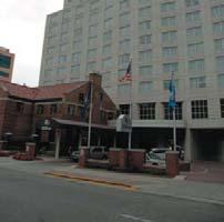
3 2. Capitol Square MIFFLIN STREET The Capitol Square continues to evolve as the center of Madison. Today, it is a central gathering space and event venue, particularly on the weekends. Recently planned as a transit hub, that use is becoming less prevalent as events often push transit routes to the outer loop. The Capitol Square streets often act as event stages. Bicycle use on the Capitol Square is also reduced, primarily because of topography and traffi c signal timing. The inner streetscape is controlled by the State of Wisconsin, the outer by the City of Madison. There are signifi cant pedestrian enhancements. CARROLL STREET MAIN STREET PINCKNEY STREET PAGE 3 of 8


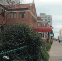
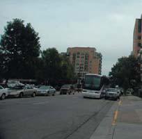
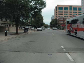
4 3. Outer Loop DAYTON STREET FAIRCHILD STREET The one way, outer loop is the primary vehicular circulation route for downtown Madison. Public parking resources are distributed along the outer loop. Signal timing and spacing and overall capacity make for more effi cient movement than on the Capitol Square. Restricted parking during the a.m. and p.m. peak hours increases capacity on these streets. Bicycle activity on the outer loop is limited; no separate bike lanes are provided. Streetscape treatments vary signifi cantly from street to street. An ineffectual wayfi nding system on the outer loop should be reevaluated. DOTY STREET WEBSTER STREET PAGE 4 of 8


5 N CARROLL ST N FAIRCHILD ST 4. NW-SE & NE-SW Diagonals S CARROLL ST S FAIRCHILD ST Diagonal streets have different accompanying land uses, but are much more pedestrian focused than other downtown streets. The scale of buildings and land use, traffi c volumes, access restrictions in some areas all contribute to the pedestrian quality. PAGE 5 of 8 REET SOUTH HAMILTON STREET NORTH HAMILTON STREET REET


6 5. Extended Capitol Loop These streets provide tertiary or no vehicular circulation and limited on-street parking support for downtown activities. Land uses are varied but tend to be less intensive. Streetscape enhancements are varied. S. Pinckney St. between blocks 88 and 105 is likely needed for vehicular circulation at a minor scale. CARROLL STREET MAIN STREET PINCKNEY STREET MIFFLIN STREET PAGE 6 of 8


7 N CARROLL ST N CARROLL ST N FAIRCHILD ST N FAIRCHILD ST WILSON STREET S CARROLL ST S CARROLL ST S FAIRCHILD ST S FAIRCHILD ST Wilson Street PAGE 7 of 8


8 Project Site E. DOTY ST g y y MLK BLVD. MADISON MUNICIPAL BUILDING S. PINCKNEY ST. BLOCK 88 BLOCK 105 g y y E. WILSON ST Sout a o g c ey o te sect o o oty & c ey Block 105 Government East Redevelopment Area + XXX Approximate elevation- based on 2 contours available at N Bird s-eye-view g Southeast towards Municipal bldg. South along Pinckney Street Southwest towards existing parking West along Wilson Street PAGE 8 of 8
Hennepin Avenue Reconstruction Washington Avenue to 12 th Street
 CITY OF MINNEAPOLIS Hennepin Avenue Reconstruction Washington Avenue to 12 th Street April 2016 1 Upcoming Opportunities Public Meeting #2 April 25, 2016 Minneapolis Central Library Doty Board Room Repeat
El Camino Real Specific Plan. TAC/CAC Meeting #2 Aug 1, 2018
 El Camino Real Specific Plan TAC/CAC Meeting #2 Aug 1, 2018 Land Use Alternatives Goals and Tradeoffs Parks & open space Housing Retail & services Civic spaces Parking Community gathering spaces 3 Alternatives
Blair/Williamson Intersection Expressed Needs
 Blair/Williamson Intersection Expressed Needs NORTH Blair Street is a barrier for pedestrians and bicycles Relocate Capitol City Trail crossing from Blair Street and John Nolen Drive intersection to Williamson
Welcome. If you have any questions or comments on the project, please contact:
 Welcome This drop-in public open house is intended to provide information about the Bay Street bike lanes project. This project proposes a dedicated cycling facility along Bay Street between Aberdeen Avenue
2. TRANSPORTATION ELEMENT.
 2. TRANSPORTATION ELEMENT. The purpose of this element is to assist in establishing an adequate transportation system within the City and to plan for future motorized and non-motorized traffic circulation
CONNECTIVITY PLAN. Adopted December 5, 2017 City of Virginia Beach
 CONNECTIVITY PLAN Adopted December 5, 2017 City of Virginia Beach CONTENTS 1.0 Background & Purpose... 2 2.0 Existing Inventory & Analysis... 3 ViBe District Existing Walking Conditions... 4 3.0 ViBe District
Princeton Avenue and Spruce Street Transportation and Site Access Enhancements Project
 Princeton Avenue and Spruce Street Transportation and Site Access Enhancements Project Mercer County Planning Division AECOM Transportation (formerly DMJM Harris) January 29, 2009 Agenda Project Status
Kansas City Area Transportation Authority. Downtown Transit Improvement Vision 2/11/15
 Kansas City Area Transportation Authority Downtown Transit Improvement Vision 2/11/15 Today s Meetings Downtown Transit Vision Long Term Vision for Downtown Bus Service Priorities for Short Term Implementation
Northbound San Jose Avenue & I-280 Off-Ramp Road Diet Pilot Project
 Project Overview Fed by a two-lane Interstate-280 (I-280) off-ramp, high vehicular volumes and speeds are longstanding issues along San Jose Avenue. Residents in the surrounding neighborhoods have expressed
GOAL 2A: ESTABLISH AND MAINTAIN A SAFE, CONVENIENT, AND EFFICIENT MULTI-MODAL TRANSPORTATION SYSTEM TO MOVE PEOPLE AND GOODS THROUGHOUT THE CITY.
 2. TRANSPORTATION ELEMENT The purpose of this element is to assist in establishing an adequate transportation system within the City and to plan for future motorized and non-motorized traffic circulation
COWETA HIGH SCHOOL AND EAST HIGHWAY 51
 COWETA HIGH SCHOOL AND EAST HIGHWAY 51 Lack of sidewalks along Ben Lumpkin Rd. Lack of crosswalks and ramps at intersection. Hwy 51 is wide to cross as a pedestrian. No ADA compliance or connection to
CHAPTER 1: INTRODUCTION
 CHAPTER 1: INTRODUCTION 7 8 UNION STATION GEORGETOWN: ALTERNATIVES ANALYSIS for PREMIUM TRANSIT SERVICE Premium transit is high-quality transit that offers improved reliability and speed, and includes
Comments EXECUTIVE SUMMARY
 Comments 1. Under any Alternatives, MCDOT should provide better at-grade pedestrian crossing of Georgia Avenue and Forest Glen Road, including improved crosswalks with wider medians and adequate signal
Miami Health District
 Miami Health District Streetscapes, Gateways, and Signage Basis of Design Report Study Miami Partnership Meeting July 21, 2008 Gannett Fleming EDAW The Corradino Group Sponsored by the Miami Partnership:
About the Wilmington Downtown Circulation Study
 About the Wilmington Downtown Circulation Study Part of the Wilmington i Initiatives partnership Wilmington Area Planning Council City of Wilmington Delaware Department of Transportation Delaware Transit
City of Madison, East Johnson Street North Baldwin Street to First Street Local Street Dane County
 City of Madison, East Johnson Street North Baldwin Street to First Street Local Street Dane County Public Involvement Meeting Thursday, April 28, 2016 6 to 8 P.M. Lapham Elementary School 1045 E. Dayton
Foothill Expressway Improvements Between El Monte and San Antonio
 Foothill Expressway Improvements Between El Monte and San Antonio June 29, 2017 - Los Altos Community Meeting Introduction Project Background Agenda Visit Stations: Provide Input and Ask Questions Reconvene:
City of Gainesville Transportation/Roadway Needs PROJECT SUMMARY
 A1 Roadway Resurfacing $23,846,000 TYPE: Preservation of existing system Roadway resurfacing A2 Signal Replacement $6,000,000 TYPE: Preservation of existing system Replace traffic signals. B1 W 6th St
Lessons Learned from Cycle Tracks (Class IV Bikeways) Design Practice
 Design Practice") Lessons Learned from Cycle Tracks (Class IV Bikeways) Design Practice By: Min Zhou, P.E., Principal/Vice President KOA Corporation 1 What is a Cycle Track (Class IV) TYPICAL BIKEWAY CLASSIFICATION CLASS
Lessons Learned from Cycle Tracks (Class IV Bikeways) Design Practice By: Min Zhou, P.E., Principal/Vice President KOA Corporation 1 What is a Cycle Track (Class IV) TYPICAL BIKEWAY CLASSIFICATION CLASS
Orange Center Elementary School
 Drag and drop pic and stretch/crop to the limits of the blue rectangle (delete this text box) Orange Center Elementary School Drag and drop pic and stretch/crop to the limits of the blue rectangle (delete
Richmond-Adelaide Cycle Tracks
 Public Drop-In Event Richmond-Adelaide Cycle Tracks June 25, 2018 12:00 p.m. 3:00 p.m. 4:30 p.m. 7:30 p.m. Metro Hall, Rotunda 55 John Street 1 Purpose of Event In Scope Communicate an update about the
Classification Criteria
 SCHEDULE D TO RECOMMENDED OFFICIAL PLAN AMENDMENT NO. 40 SCHEDULE C-4 Road Criteria Criteria Traffic Service Objective Land Service/Access Typical Daily Traffic Volume Flow characteristics Travel Speed
DEFINING THE STREETSCAPE DRAFT
 3 DEFINING THE STREETSCAPE Context Sensitive Design Context Sensitive Design The structuring elements of streetscapes for the City of Vaughan are road classifi cation, streetscape type and level of service.
Completing the Vision
 Villas of Positano Completing the Vision North A1A Lane Reconfiguration N. Surf Rd. Redirection of Traffic Margaritaville Resort March 4, 2014 1 Completing The Vision Project Limits Hollywood Blvd. to
CITY OF COCOA BEACH 2025 COMPREHENSIVE PLAN. Section VIII Mobility Element Goals, Objectives, and Policies
 CITY OF COCOA BEACH 2025 COMPREHENSIVE PLAN Section VIII Mobility Element Goals, Objectives, and Policies Adopted August 6, 2015 by Ordinance No. 1591 VIII MOBILITY ELEMENT Table of Contents Page Number
North Shore Transportation Improvement Strategy
 North Shore Transportation Improvement Strategy Preliminary, Near-term Recommendation 2016 April Transportation Improvement Strategy (TIS) Comprehensive and Analytical A multi-modal transportation strategy
Bicycle Corrals Portland Designing Streets NYC October 25, 2012 Roger Geller, Bicycle Coordinator Portland, OR
 Bicycle Corrals Portland 8-80 Designing Streets NYC October 25, 2012 Roger Geller, Bicycle Coordinator Portland, OR Build it and they will come 1990 2012 Build it better 2012 background With bike boxes
CAPITOL DRIVE & FOND DU LAC AVENUE INTERSECTION ANALYSIS. Urban Planning 772 SARAH BREGANT, RYAN PETERSON, & MATT WERDERITCH
 CAPITOL DRIVE & FOND DU LAC AVENUE INTERSECTION ANALYSIS Urban Planning 772 SARAH BREGANT, RYAN PETERSON, & MATT WERDERITCH OVERVIEW N 51 ST BOULEVARD N 51 ST BOULEVARD 12,100 44,700 W CAPITOL DRIVE 52,600
Summary: Mercer County Princeton Avenue & Spruce Street Study January 2009
 Summary: Several recent studies have assessed potential development and redevelopment opportunities in the Mercer Crossing area of Trenton, Ewing, and Lawrence. This Princeton Avenue and Spruce Street
FINAL REPORT EXECUTIVE SUMMARY: REPORT OF THE SOUTH CAPITOL DISTRICT PLANNING COMMITTEE
 FINAL REPORT EXECUTIVE SUMMARY: REPORT OF THE SOUTH CAPITOL DISTRICT PLANNING COMMITTEE Prepared for: SOUTH CAPITOL TRANSIT ORIENTED DEVELOPMENT (TOD) CITY OF MADISON, WI August 2014 Prepared by: CITY
City of Wausau Wausau Center Urban Design and Transportation Master Plan. Design Workshop // October 18, 2018
 City of Wausau Wausau Center Urban Design and Transportation Master Plan Design Workshop // October 18, 2018 Design Workshops // October 15-18 Workshop Study Evaluate circulation and parking patterns around
MARKET/JFK VISION ZERO PILOT PROJECT FEBRUARY 2019 EVALUATION REPORT
 MARKET/JFK VISION ZERO PILOT PROJECT FEBRUARY 2019 EVALUATION REPORT WHY IS THIS PROJECT IMPORTANT? Market Street and JFK Boulevard in Center City are key east-west corridors in the core business district.
Public Open House #2. THE CITY OF NORTH VANCOUVER CHESTERFIELD AVENUE CYCLING IMPROVEMENTS (4th - 13th STREET) JULY 2013
 JULY 2013") CHESTERFIELD AVENUE CYCLING IMPROVEMENTS (4th - 13th Street) Public Open House #2 1 Chesterfield Avenue provides an important north/south connection between Lonsdale Quay and West 23rd Street Purpose of
CHESTERFIELD AVENUE CYCLING IMPROVEMENTS (4th - 13th Street) Public Open House #2 1 Chesterfield Avenue provides an important north/south connection between Lonsdale Quay and West 23rd Street Purpose of
Complete Streets in Constrained Corridors: Chicago s Central Loop BRT
 Complete Streets in Constrained Corridors: Chicago s Central Loop BRT NACTO Designing Cities Conference October 24, 2012 Luann Hamilton, Deputy Commissioner What is BRT? Bus-based system that improves
Board-Approved Funding Awards for Cycle 4 Active Transportation Grant Program Projects (in Order of Project Rankings) Approved on
 Approved on") CAPITAL Large Category Projects Board-Approved Funding Awards for Cycle 4 Active Transportation Grant Program Projects (in Order of Project Rankings) Approved on 07-27-18 1 La Mesa University Ave Pedestrian
CAPITAL Large Category Projects Board-Approved Funding Awards for Cycle 4 Active Transportation Grant Program Projects (in Order of Project Rankings) Approved on 07-27-18 1 La Mesa University Ave Pedestrian
Recommendations. Central Salem Mobility Study
 Central Salem Mobility Study The Central Salem Mobility Study evaluated a range of multimodal transportation issues affecting downtown Salem, including circulation, access, and safety for people traveling
STONY PLAIN ROAD STREETSCAPE
 Jasper Place Revitalization Strategy: Vision The people involved in the Jasper Place Revitalization Strategy envision: Goal 1: Feeling safe in our community Create a community where feeling safe is common--where
TRANSPORTATION STANDARDS
 INTRODUCTION LOCAL STREETS ON-STREET PARKING SIDEWALKS STREET LIGHTING STREET FURNISHINGS TRAFFIC CALMING STREET TREES MEDIAN PLANTING BOULEVARD LOCATIONS VILLAGE CENTER STREET LOCATIONS RESIDENTIAL STREET
Bikeway action plan. Bicycle Friendly Community Workshop March 5, 2007 Rochester, MN
 Bikeway action plan Summary The was held on March 5, 2007 at the Rochester Mayo Civic Center. The workshop was hosted by Rochester-Olmsted County Planning Department in collaboration with the League of
Approaches. Livable Neighborhood Design. Examples. Traditional neighborhood development. CE 594 University of Wisconsin- Milwaukee
 Approaches Livable Neighborhood Design CE 594 University of Wisconsin- Milwaukee Traditional neighborhood design (TND), new urbanism, transit friendly design, transit oriented development and walkable
THE ALAMEDA CONCEPT DESIGN COMMUNITY MEETING 3. A Plan for The Beautiful Way JANUARY 28, 2010
 CONCEPT DESIGN COMMUNITY MEETING 3 JANUARY 28, 2010 AGENDA INTRODUCTION COMMUNITY INPUT ROADWAY STUDIES STREETSCAPE DESIGN STATIONS DISCUSSION SUMMARY AND DISCUSSION NEXT STEPS CLOSE INTRODUCTION SCHEDULE
Southwest Bus Rapid Transit (SW BRT) Functional Planning Study - Executive Summary January 19 LPT ATTACHMENT 2.
 Functional Planning Study - Executive Summary January 19 LPT ATTACHMENT 2.") Southwest Bus Rapid Transit (SW BRT) Functional Planning Study - Executive Summary 2011 January 19 1 of 19 Introduction This executive summary presents the results of the Southwest Bus Rapid Transit (SW
Southwest Bus Rapid Transit (SW BRT) Functional Planning Study - Executive Summary 2011 January 19 1 of 19 Introduction This executive summary presents the results of the Southwest Bus Rapid Transit (SW
Bridges and Arizona Crossings
 Circulation and Transportation 5-11 Discovery Street/Barham Drive. Discovery Street is planned 5.4.3 Specific Plan Circulation Improvements to be extended eastward from its terminus at Craven Road Circulation
Project Description Form 8EE
 Project Description Form 8EE Basic Project Information Submitting Jurisdiction/Agency: Town of Dumfries Project Title: Route 1 (Fraley Blvd) Widening: Brady's Hill Road to Dumfries Road Project Location:
Central Avenue Corridor Study FPID Number:
 Central Avenue Corridor Study FPID Number: 437932-1-18-01 City Commission Presentation 1 March 27, 2018 Meeting Agenda 1. Introductions 2. Project Overview 3. Opportunity for Economic Development 4. Healthy
Capital Metro Downtown Multimodal Station
 Capital Metro Downtown Multimodal Station Open House December 11, 2015 Project Goals & Objectives 1 2 3 4 Address near- and long- term MetroRail operational needs Address existing safety issues and modal
DEPARTMENT OF ENVIRONMENTAL SERVICES. North Harrison Street (Lee Highway to Little Falls Road) Comparative Analysis. Prepared for:
 Comparative Analysis. Prepared for:") DEPARTMENT OF ENVIRONMENTAL SERVICES North Harrison Street (Lee Highway to Little Falls Road) Comparative Analysis Prepared for: Arlington County Department of Environmental Services 2100 Clarendon Boulevard,
DEPARTMENT OF ENVIRONMENTAL SERVICES North Harrison Street (Lee Highway to Little Falls Road) Comparative Analysis Prepared for: Arlington County Department of Environmental Services 2100 Clarendon Boulevard,
Traffic Improvements for the Transit Oriented Development District (TODD) Meriden Public Library March 11, 2014
 Meriden Public Library March 11, 2014") Traffic Improvements for the Transit Oriented Development District (TODD) Meriden Public Library March 11, 2014 Project Overview Coordinate roadway improvements with other major projects HUB Flood Control
Traffic Improvements for the Transit Oriented Development District (TODD) Meriden Public Library March 11, 2014 Project Overview Coordinate roadway improvements with other major projects HUB Flood Control
5858 N COLLEGE, LLC N College Avenue Traffic Impact Study
 5858 N COLLEGE, LLC nue Traffic Impact Study August 22, 2016 Contents Traffic Impact Study Page Preparer Qualifications... 1 Introduction... 2 Existing Roadway Conditions... 5 Existing Traffic Conditions...
2.0 Existing Conditions
 20 2.0 Existing Conditions 2.1 Land Use, Future Growth Patterns, Physical Barriers Geographic Overview Sutter County s land use pattern is characterized by extensive agricultural areas, significant natural
Transforming Traffic Signals to Support Sustainability: Applications, Ideas, & Research
 Transforming Traffic Signals to Support Sustainability: Applications, Ideas, & Research MARCH 4, 2011 Presented by: Peter Koonce, PE Division Manager, City of Portland Signals, Street Lighting, & ITS Overview
KEARNY MESA COMMUNITY PLAN UPDATE
 KEARNY MESA COMMUNITY PLAN UPDATE January 18, 2018 SUBCOMMITTEE MEETING Mobility Concepts and Urban Design Presentation Outline Mobility Concepts: Multimodal Planning Toolbox Presentation and Activities
City of Madison, East Johnson Street North Baldwin Street to First Street Local Street Dane County
 City of Madison, East Johnson Street North Baldwin Street to First Street Local Street Dane County Public Involvement Meeting Thursday, November 10, 2016 5:30 to 7 P.M. Festival Foods 810 E. Washington
Short-Term Enhancements Improvements to keep Austin moving. MetroRapid
 Short-Term Enhancements Improvements to keep Austin moving Long-Term Investments Projects to support our future Mobility Hubs MetroRapid MetroRail MetroExpress Commuters Connectors Circulators Project
TECHNICAL MEMORANDUM. Introduction
 TECHNICAL MEMORANDUM To: From: John M. Welsh Chris Furlong AHC, Inc. Andrew T. Smith, P.E. Edward Y. Papazian, P.E. Kimley-Horn and Associates, Inc. Date: July 6, 2017 Subject: 200 9 th reet South Redevelopment
A Step-by-Step Guide to Complete Streets Implementation. Mark A. Cole, PE Charlotte Department of Transportation
 A Step-by-Step Guide to Complete Streets Implementation Mark A. Cole, PE Charlotte Department of Transportation tcat Complete Streets Forum April 23, 2010 Speaking Points Complete Streets Implementation
Construction Staging Area Vaughan Road
 REPORT FOR ACTION Construction Staging Area - 109 Vaughan Road Date: May 25, 2017 To: Toronto and East York Community Council From: Acting Director, Transportation Services, Toronto and East York District
OCALA/MARION TPO CITY OF BELLEVIEW CORRIDOR PLAN STUDY PRESENTATION TO THE BELLEVIEW CITY COMMISSION JANUARY 25, :00 PM
 OCALA/MARION TPO CITY OF BELLEVIEW CORRIDOR PLAN STUDY PRESENTATION TO THE BELLEVIEW CITY COMMISSION JANUARY 25, 2016 6:00 PM STUDY AREA Ocala/Marion TPO US-441 Corridor Study 2 Ocala/Marion TPO US-441
Downtown Naples Mobility and Connectivity Study. Naples City Council Presentation January 2017
 Downtown Naples Mobility and Connectivity Study Naples City Council Presentation January 2017 Agenda 1. Introduction 2. Scope Review 3. Project Schedule 4. Existing Conditions 5. Public Charrette 6. Mobility
Outreach Approach RENEW SF served as the primary liaison with the North Beach community; the Chinatown. Executive Summary
 Executive Summary Executive Summary The Columbus Avenue Neighborhood Transportation Study s objective is to identify changes to transportation infrastructure and policies that could enhance the livability
STADIUM DISTRICT CENTER PLATFORM TACOMA LINK EXPANSION. Existing bus stop remains. Existing parallel parking removed for bus access.
 STADIUM DISTRICT CENTER PLATFORM Inbound to Tacoma Dome Redevelopment increases parking on Division Ave Existing bus stop remains TULLY S Existing parallel parking removed for bus access Ped plaza or landscaping
Blackfalds Downtown. Architectural Guidelines: Streetscape
 Blackfalds Downtown Architectural Guidelines: Streetscape Streetscape INTRODUCTION A variety of street furniture has been chosen for locations within the Town of Blackfalds Downtown and highway commercial
100% All Bike DC Loop Ride!
 100% All Bike DC Loop Ride! Ride Leader: Chris Roell Cell Number: 202-607-5565 Ride Social Media Hashtags: #bikedcloop #dcloop #bikedc #exploredc #washingtondc #thedistrict #dc #4thofjulybikeride #4thofjuly
Typical Cross Section: DOWNTOWN (Observer Highway - 8th Street)
") Typical Cross Section: DOWNTOWN (Observer Highway - 8th Street) DRAFT SEPTEMBER 23, 14 1 Washington Street Typical Block Downtown Typical Block: DOWNTOWN (Observer Highway - 8th Street) New crosswalks
Typical Cross Section: DOWNTOWN (Observer Highway - 8th Street) DRAFT SEPTEMBER 23, 14 1 Washington Street Typical Block Downtown Typical Block: DOWNTOWN (Observer Highway - 8th Street) New crosswalks
City of El Cerrito San Pablo Avenue Specific Plan. Capital Improvement Program
 City of El Cerrito San Pablo Avenue Specific Plan Capital Improvement Program May 2015 San Pablo Avenue Intersection Improvements San Pablo Avenue and Hill Street/Eastshore Boulevard Background Existing
Complete Streets Process and Case Study: Taft / McMillian Two-Way Street Conversion Cincinnati, Ohio. Traffic Engineering Workshop June 4, 2014
 Complete Streets Process and Case Study: Taft / McMillian Two-Way Street Conversion Cincinnati, Ohio Traffic Engineering Workshop June 4, 2014 Complete Streets Streets that enable safe access for users
West Capitol Avenue Road Rehabilitation and Safety Enhancement Project
 West Capitol Avenue Road Rehabilitation and Safety Enhancement Project Stakeholder Focus Group Meeting #2 Tuesday, August 28, 2018 7:00 8:00 a.m. West Sacramento City Hall 1110 West Capitol Avenue, West
C C C
 C-012-001 Thank you for your support for the creation of new public space and nonmotorized access between downtown and the waterfront through the Overlook Walk, the East-West Connections, and the Promenade.
CLINT THAYER, FOCAL FLAME PHOTOGRAPHY SPECTATOR GUIDE SUNDAY, NOVEMBER 11, 2018 MADISONMARATHON.ORG
 SPECTATOR GUIDE SUNDAY, NOVEMBER 11, 2018 MADISONMARATHON.ORG CLINT THAYER, FOCAL FLAME PHOTOGRAPHY WELCOME TO THE MADISON MARATHON TABLE OF CONTENTS 2018 SCHEDULE 3 FAQs & EXPO 4 RACEYJOY & RUNNER TRACKING
Observations and Ideas: Toomer s Corner Streetscape Improvements
 Observations and Ideas: Toomer s Corner Streetscape Improvements AUBURN DOWNTOWN MASTER PLAN planning downtown s future August 26, 2013 Observations: Vertical Clutter at Corners 6 3 7 5 9 2 8 4 1 Excess
ALLEY 24 TRAFFIC STUDY
 ALLEY 24 TRAFFIC STUDY in City of Frostburg, Maryland January 2013 3566 Teays Valley Road Hurricane, WV Office: (304) 397-5508 www.denniscorporation.com Alley 24 Traffic Study January 2013 Frostburg, Maryland
ROAD SAFETY AUDIT (RSA) Barbur Blvd: SW Capitol Hwy to SW Naito Parkway (M.P to M.P. 1.95)
 Barbur Blvd: SW Capitol Hwy to SW Naito Parkway (M.P to M.P. 1.95)") ROAD SAFETY AUDIT (RSA) Barbur Blvd: SW Capitol Hwy to SW Naito Parkway (M.P. 6.30 to M.P. 1.95) SWNI Meeting November July 18, 2016 19, 2015 Portland, Oregon BARBUR ROAD SAFETY AUDIT FHWA RSA Process
ROAD SAFETY AUDIT (RSA) Barbur Blvd: SW Capitol Hwy to SW Naito Parkway (M.P. 6.30 to M.P. 1.95) SWNI Meeting November July 18, 2016 19, 2015 Portland, Oregon BARBUR ROAD SAFETY AUDIT FHWA RSA Process
CONTEXT SENSITIVE STREETS STANDARDS COMMITTEE
 CONTEXT SENSITIVE STREETS STANDARDS COMMITTEE February 23, 2015 Prepared by: Denise Chaplick, AICP City Jacksonville Bicycle and Pedestrian Coordinator Source: NCDOT Complete Streets Planning and Design
LeBreton Flats. National Capital Commission. Pedestrian and Cyclist Plan. Prepared for: By:
 LeBreton Flats Pedestrian and Cyclist Plan Prepared for: National Capital Commission By: July 2002 TABLE OF CONTENTS 1.0 INTRODUCTION...1 1.1 Background...1 1.2 Study Objectives...2 2.0 POLICY REVIEW...2
Conversion of One-Way Couplet Streets to Two-Way
 Conversion of One-Way Couplet Streets to Two-Way May 5, 2016 Oklahoma Traffic Engineers Association 2016 Spring Meeting, Tulsa, OK Kevin St. Jacques, P.E., PTOE, PTP Freese and Nichols Overview Initial
BRIEFING ON PROPOSED ADDITIONS AND CHANGES Additions and Changes to Projects Proposed for Inclusion in the 2015 CLRP Update
 BRIEFING ON PROPOSED ADDITIONS AND CHANGES Additions and Changes to Projects Proposed for Inclusion in the 2015 CLRP Update January 23, 2015 Travel Forecasting Subcommittee What is the CLRP? Federally
5/31/2016 VIA . Arwen Wacht City of Sacramento Community Development Department 300 Richards Blvd., 3 rd Floor Sacramento, CA 95811
 5/31/2016 VIA EMAIL Arwen Wacht City of Sacramento Community Development Department 300 Richards Blvd., 3 rd Floor Sacramento, CA 95811 RE: El Pollo Loco (P16-028) Dear Ms. Wacht: WALKSacramento has reviewed
Austin Avenue Bridges Project. Public Meeting Summary
 Austin Avenue Bridges Project Public Meeting Summary June 29, 2016 Red Table Safety and Connectivity Notes: 1. Would like to see forensic report evaluations 2. What is the lifespan? 3. Extend safety considerations
REVIEW OF LOCAL TRAFFIC FLOW / LONG RANGE PLANNING SOLUTIONS STUDY
 ITEM Town of Atherton TRANSPORTATION COMMITTEE STAFF REPORT TO: FROM: MEMBERS OF THE COMMITTEE ROBERT OVADIA, PUBLIC WORKS DIRECTOR DATE: FEBRUARY 12, 2019 SUBJECT: REVIEW OF LOCAL TRAFFIC FLOW / LONG
Traffic and Flood Control Improvements in the Transit Oriented Development District Project Updates Tuesday, November 29, 2016 Meriden Public Library
 Traffic and Flood Control Improvements in the Transit Oriented Development District Project Updates Tuesday, November 29, 2016 Meriden Public Library Presentation Format Project Goals and Overview Sidewalk
5. Automobile Circulation, Wayfinding and Signage
 5. Automobile Circulation, Wayfinding and Signage Policy: The City Center should have a balanced, safe, and interconnected circulation system that provides expanded travel opportunities for transit, pedestrian,
Chicago Safe Routes to School Safe Routes to High School (SRTS/SRTHS)
") Chicago Safe Routes to School Safe Routes to High School (SRTS/SRTHS) Marshall Community High School and Faraday Elementary School Recommended Improvements Agenda Goals Related Programs Project Location/Area
Chicago Safe Routes to School Safe Routes to High School (SRTS/SRTHS) Marshall Community High School and Faraday Elementary School Recommended Improvements Agenda Goals Related Programs Project Location/Area
o n - m o t o r i z e d transportation is an overlooked element that can greatly enhance the overall quality of life for the community s residents.
 N o n - m o t o r i z e d transportation is an overlooked element that can greatly enhance the overall quality of life for the community s residents. 84 Transportation CHAPTER 11 INTRODUCTION Transportation
Ada County Highway District
 Ada County Highway District LIVABLE STREET DESIGN GUIDE ADOPTED D MAY 27, 2009 0 Committed to Service This page is intentionally left blank. TABLE OF CONTENTS 1.0 Basics of the Livable Street Design Guide
PEDESTRIAN ACTION PLAN
 CITY OF SANTA MONICA PEDESTRIAN ACTION PLAN DRAFT OCTOBER 2015 Safe Streets Santa Monica, December 3, 2015 Beth Rolandson, AICP Principal Transportation Planner Strategic + Transportation Planning, Planning
City of Los Angeles CALIFORNIA
 DEPARTMENT OF CITY PLANNING 00 N. SPRING STREET, ROOM 55 LOS ANGELES, CA 9001-4801 AND 66 VAN NUYS BLVD., SUITE 351 VAN NUYS, CA 91401 C CITY PLANNING COMMISSION WILLIAM ROSCHEN PRESIDENT REGINA M. FREER
Draft MOBILITY ELEMENET. Community Meeting May 22, 2013
 Draft MOBILITY ELEMENET Community Meeting May 22, 2013 Agenda Presentation Ira Brown New Mobility Paradigm Movement of People Implementation Q&A Ira Brown and Dave Roseman Small Group Discussion at Each
Public Information Meeting. Orange Camp Road. Dr. Martin Luther King Jr. Beltway to I-4. Presented by: Volusia County August 2, 2018
 Public Information Meeting Orange Camp Road Dr. Martin Luther King Jr. Beltway to I-4 Presented by: Volusia County August 2, 2018 1 Project Goals To improve the operations and safety for Orange Camp Road
5 CIRCULATION AND STREET DESIGN
 5 CIRCULATION AND STREET DESIGN This chapter describes circulation and streetscape improvements proposed for the Northwest Chico Specific Plan Area. It includes detailed design specifications for existing
Completing the Street: Denning Drive
 Completing the Street: Denning Drive Public Workshop and Walking Audit Winter Park Civic Center May 12, 2016 Completing the Street What Makes This a Complete Street? Completing the Street Complete Streets
Bicycle and Pedestrian Advisory Committee (BPAC) November 21, 2013
 November 21, 2013") Bicycle and Pedestrian Advisory Committee (BPAC) November 21, 2013 OVERALL LAND USE CONCEPT Overall Broadway Valdez District: 95.5 acres (35.1 acres right-of ways + 60.4 acres developable land) Plan Subareas:
Bicycle and Pedestrian Advisory Committee (BPAC) November 21, 2013 OVERALL LAND USE CONCEPT Overall Broadway Valdez District: 95.5 acres (35.1 acres right-of ways + 60.4 acres developable land) Plan Subareas:
M-58 HIGHWAY ACCESS MANAGEMENT STUDY Mullen Road to Bel-Ray Boulevard. Prepared for CITY OF BELTON. May 2016
 M-58 HIGHWAY ACCESS MANAGEMENT STUDY Prepared for CITY OF BELTON By May 2016 Introduction Missouri State Highway 58 (M-58 Highway) is a major commercial corridor in the City of Belton. As development has
Ajax: The Road to Complete Streets
 Ajax: The Road to Complete Streets Hubert Ng, Senior Transportation Planner Elysia Leung, Transportation Demand Management Coordinator Complete Streets Forum October 1, 2015 Overview 1 2 Introduction to
Joe Routt Boulevard. Access Design Options
 Access Design Options Impacted area highlighted in yellow. Access Design Option 1 This option would involve closing Joe Routt between Gene Stallings Blvd. and Houston St. to car and bus traffic, creating
NJDOT Complete Streets Checklist
 Background The New Jersey Department of Transportation s Complete Streets Policy promotes a comprehensive, integrated, connected multi-modal network by providing connections to bicycling and walking trip
If a person walks within this focus area, these are examples of the places he or she could walk to or from:
 Portland Hillsdale Hillsdale Portland The Hillsdale focus area is located in the City of Portland. It is situated approximately three miles from the City of Portland s downtown, 5.5 miles from the City
Appendix C. NORTH METRO STATION AREA TRAFFIC IMPACT STATEMENT 88th Avenue Station
 Appendix C NORTH METRO STATION AREA TRAFFIC IMPACT STATEMENT 88th Avenue Station Prepared for: Regional Transportation Department and URS Corporation as part of the North Metro EIS David Evans and Associates,
Toronto and East York Community Council. Director, Transportation Services, Toronto and East York District
 No Turn on Red Regulations STAFF REPORT ACTION REQUIRED Date: June 1, 2010 To: From: Toronto and East York Community Council Director, Transportation Services, Toronto and East York District Wards: Trinity
Ownership Lots 17 & 18 (Part of Lot 14), Montgomery Auto Sales Park
, Montgomery Auto Sales Park") Traffic Impact Analysis Ownership Lots 17 & 18 (Part of Lot 14), Montgomery Auto Sales Park Silver Spring, MD Lot 17: Site Plan No. 821413 Lot 18: Site Plan No. 821414 Filing Number: 13-TS-1198527A Prepared
Traffic Impact Analysis Ownership Lots 17 & 18 (Part of Lot 14), Montgomery Auto Sales Park Silver Spring, MD Lot 17: Site Plan No. 821413 Lot 18: Site Plan No. 821414 Filing Number: 13-TS-1198527A Prepared
Planning Study SR 976. Project Advisory Team Meeting May 24, 2017
 ` SR 976 BIRD ROAD/SW 40TH STREET FROM SR 821/HEFT TO SR 5/US-1 Miami-Dade County, Florida FPID No.: 434845-4-22-01 Planning Study Project Advisory Team Meeting May 24, 2017 1 Agenda Introductions Project