Upper Market Street Bike Lane Project
|
|
|
- Spencer Morgan
- 6 years ago
- Views:
Transcription

1 Upper Market Street Bike Lane Project 17th Street to Octavia Boulevard SAN FRANCISCO, CALIFORNIA
2 Agenda San Francisco & Sustainable Transportation Project Goals Outreach & Coordination Project Overview Discussion Next Steps
3 Policy and Planning for Sustainable Transportation in San Francisco 1973 Transit First Policy (City Charter) Within San Francisco, travel by public transit, by bicycle and on foot must be an attractive alternative to travel by private automobile Bicycling shall be promoted by encouraging safe streets for riding, convenient access to transit, bicycle lanes and secure bicycle parking 2006 Better Streets Policy Decisions regarding the design and use of the City s limited public street space shall prioritize space for pedestrians, bicycles, and public transit over space for automobiles Climate Action Plan Increase bicycling and walking as alternatives to driving 2009 Adopted Bicycle Plan
4 Bicycle Plan Goals Overall Goal: Increase safe bicycle use Refine & expand the existing bicycle route network Ensure plentiful, high-quality bicycle parking Educate the public about bicycle safety Improve bicycle safety through targeted enforcement Promote & encourage safe bicycling

5 Bicycle Plan EIR and Proposed Improvements Near-term improvements include on-street projects - Bicycle lanes - Shared roadway markings - Bicycle parking - Signage improvements

6 2007 Census: Bicycling Continues to Grow 2.7% bicycle to work in SF US average = 0.5% CA average = 0.9% Citywide Bicycle Count : 54% increase in bicycling SFMTA Survey Results: 6% of all trips by residents in San Francisco made by bicycle 75-80% people surveyed feel there are not enough bicycle lanes in San Francisco

7 Customers come in many ways
8 Existing Bicycle Route Network 45 miles of bicycle lanes 23 miles of streets with Sharrows 6 % of SF Streets
9 Proposed Near-Term Projects Proposed increase to 79 miles of bike lanes Proposed increase to 98 miles of streets with Sharrows

10 Project Area Map Market Street, 17th to Valencia Streets
11 Project Goal Create continuous bike lanes on both sides of Market Street between 17th Street and Octavia Boulevard Improve bicycle travel while enhancing safety for motorists, pedestrians and bicyclists Better bike facilities for bicyclists of all skill levels Make traffic more predictable at intersections Slower speeds
12 Outreach and Coordination Meetings with neighborhood groups: MUMC, Castro CBD, DTNA and SFBC Planned meeting with Castro/EVNA Meetings with Individual merchants and residents Coordination with other plans: Upper Market Design Guidelines and Community Vision and Recommendations Neighborhood Beatification and Safety Plan Better Streets Plan San Francisco 2009 Bicycle Plan


13 Proposal Create continuous bike lanes on both sides of Market Street between 17 th Street and Octavia Boulevard

14 Existing Conditions Looking southwest on Market St. bicyclist heading towards Buchanan St.
15 Market at Noe Example
16 Remove Right Turn Lanes Eastbound: Market at Noe Sanchez and Dolores Westbound: Market at Sanchez Approaching intersections, bike lanes serve as the right-turn lane for all vehicles by definition
17
18 Parking Removal Installation of bike lanes removes 15 parking spaces Parking recouped at nearby areas by reconfiguring existing parking Converting parallel parking on Noe Street between Market and Beaver to 45 degree, angled parking to offset parking lost on Market Street at Noe Street Modifying metered parking spaces on Market Street
19 Market Street at Noe Street Parking Removal
20 Market Street at Noe Street Angled Parking
21 Relocate & Add Motorcycle Parking Noe Street at Market move across Noe Street to accommodate northbound turns from Market onto Noe Added 8 new metered motorcycle parking spaces
22 Proposed Motorcycle Parking Spaces at Noe
23 Trader Joe s Transportation Impact Study has been delayed Needs a conditional use permit to use the former Tower Records site Upper Market Bike Lane Project included in the study SFMTA recommends active loading in the bicycle lane only during off-peak hours as part of the conditional use permit During TIS review stages we will request that this project be coordinated Develop mitigation/improvement measures, if necessary, to improve transportation operations
24 Parking Improvement Opportunities Increase bike parking Sidewalk racks Bike corrals Reconfigure commercial loading zones (yellow zones)
25 Bicycle Parking Why On-Street Bike Parking? Sidewalks can t absorb more bicycle racks Reduce clutter increase sidewalk space for pedestrians Cyclists are a large or growing number of your customers and have no place to lock their bikes It s Good for Business Up to 8 customers can park in one parking space instead of 1 or 2 customers in an automobile. It s Good for the Environment Each 4 mile round trip by bicycle replacing a trip by car eliminates 15 lbs of particulate pollution
26 Bike Parking continued Identify new locations for bike parking on Market Street sidewalk Bike corrals recently installed on Valencia with favorable results Heavy bike parking demand at the intersections of Market and Noe streets and near the Market Street boarding island at Duboce Street Addition of bike corrals could add dozens of parking spaces to the area where should they go?
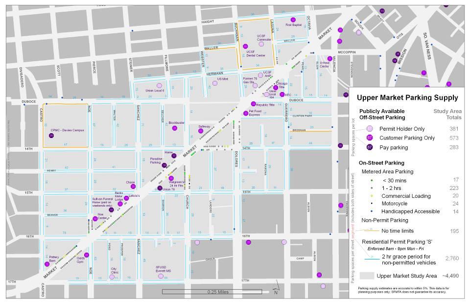
27 Commercial Loading Zone Assessment Locations are being assessed for effectiveness Zones can be moved to block ends to make it easier for trucks to pull in and out of the space New loading zones in project area (yellow, green, Market Street, Noe Street, Castro Street) Upper Market Parking Supply Map Merchants can direct customers to locations with additional public parking Identifies opportunities for coordination among business (maximize parking availability by time of day)
28
29 Discussion Bicycle parking Recouping parking loss Angled parking on Noe Street Meter changes on Market Street Other
30 Next Steps Final project modifications Environmental review Legislative approval process Public hearing 7/30/2010 SFMTA Board meeting 9/7/2010 Project Implementation ~ Winter 2010
31 Contact Us Adam Gubser (415) SFMTA Bicycle Program
32 Project-Related Images

33 San Francisco, 14th Street at Market Street 14th Street looking west towards Market Street where median and sidewalk will become connected
 and west towards 14th Street (on right) where median and sidewalk will become")
34 San Francisco, 14th Street at Market Street Looking northeast towards Market Street (on left) and west towards 14th Street (on right) where median and sidewalk will become connected.

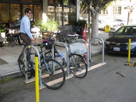
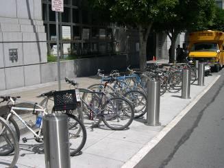
35 Bike Parking Examples

36 8 th Avenue & Clement Street Angled Parking Example
SAN FRANCISCO MUNICIPAL TRANSPORTATION AGENCY
 THIS PRINT COVERS CALENDAR ITEM NO.: 10.3 DIVISION: Sustainable Streets BRIEF DESCRIPTION: SAN FRANCISCO MUNICIPAL TRANSPORTATION AGENCY Approving various traffic and parking modifications on Bay Street
Data Analysis February to March Identified safety needs from reported collisions and existing travel patterns.
 Welcome! Thank you for participating in today s Valencia Bikeway Improvements workshop. Data Analysis February to March Identified safety needs from reported collisions and existing travel patterns. Initial
SAN FRANCISCO MUNICIPAL TRANSPORTATION AGENCY
 THIS PRINT COVERS CALENDAR ITEM NO: 10.2 DIVISION: Sustainable Streets BRIEF DESCRIPTION: SAN FRANCISCO MUNICIPAL TRANSPORTATION AGENCY Approving various routine parking and traffic modifications. SUMMARY:
Protected Bike Lanes in San Francisco Mike Sallaberry SFMTA NACTO Workshop - Chicago IL
 Protected Bike Lanes in San Francisco Mike Sallaberry SFMTA 10 14 2011 NACTO Workshop - Chicago IL San Francisco 2 nd Highest Density in the U.S. 47 square miles Mild Climate Market Population ~810,000
Data Analysis February to March Identified safety needs from reported collisions and existing travel patterns.
 Welcome! Thank you for participating in today s Valencia Bikeway Improvements workshop. Data Analysis February to March Identified safety needs from reported collisions and existing travel patterns. Initial
SAN FRANCISCO MUNICIPAL TRANSPORTATION AGENCY
 THIS PRINT COVERS CALENDAR ITEM NO.: 10.2 DIVISION: Sustainable Streets BRIEF DESCRIPTION: SAN FRANCISCO MUNICIPAL TRANSPORTATION AGENCY Approving various routine parking and traffic modifications. SUMMARY:
SAN FRANCISCO MUNICIPAL TRANSPORTATION AGENCY
 THIS PRINT COVERS CALENDAR ITEM NO. : 12 DIVISION: Sustainable Streets BRIEF DESCRIPTION: SAN FRANCISCO MUNICIPAL TRANSPORTATION AGENCY Approving various bicycle improvements and traffic modifications
SAN FRANCISCO MUNICIPAL TRANSPORTATION AGENCY BOARD OF DIRECTORS. RESOLUTION No
 SAN FRANCISCO MUNICIPAL TRANSPORTATION AGENCY BOARD OF DIRECTORS RESOLUTION No. 15-031 WHEREAS, Transportation Code Division II, Section 909 authorizes the Director of Transportation to install and permit
Bicycle Master Plan Goals, Strategies, and Policies
 Bicycle Master Plan Goals, Strategies, and Policies Mobilizing 5 This chapter outlines the overarching goals, action statements, and action items Long Beach will take in order to achieve its vision of
2014/2015 BIKE ROUTE PLAN 83 AVENUE PROTECTED BIKE LANE
 About the Project 2014/2015 BIKE ROUTE PLAN The City of Edmonton is planning a major bike route on the south side of Edmonton. This bike route is one part of a plan to provide citizens with transportation
2014/2015 BIKE ROUTE PLAN 83 AVENUE PROTECTED BIKE LANE
 About the Project The City of Edmonton is planning a major bike route on the southside of Edmonton. The Strathcona Bike Route will connect the communities of Strathcona, Garneau and the University area,
Welcome! San Jose Avenue Open House August 25, 2015
 Welcome! San Jose Avenue Open House August 25, 2015 Vision Zero The City and County of San Francisco adopted Vision Zero San Francisco Vision Zero High Injury Network as a policy in 2014, committing an
Bicycle Network. Vision Zero San Francisco The City and County of San
 PROJECT BACKGROUND Project Needs 1. 17th between Church and Sanchez is identified as a location where there is a disproportionate number of crashes involving people riding bikes. 2. There is currently
Project Goal and Description. Why Broadway? Broadway SFMTA.COM/BROADWAY. The goal of the Broadway Safety Improvement
 PROJECT OVERVIEW Project Goal and Description The goal of the Broadway Safety Improvement d St Van Ness Ave Project is to improve safety and comfort for all who Franklin St Hyde St Octavia St Gough St
Station 1: Street & Sidewalk Upgrades
 Station 1: Street & Sidewalk Upgrades Existing no left turn; Potential left turn arrow, see Circulation Study boards for more information Thru-lane guidance Improved lead-in green bike lane 17TH ST CASTRO
SAN FRANCISCO MUNICIPAL TRANSPORTATION AGENCY
 THIS PRINT COVERS CALENDAR ITEM NO. : 10.2 DIVISION: Sustainable Streets BRIEF DESCRIPTION: SAN FRANCISCO MUNICIPAL TRANSPORTATION AGENCY Adopting Conceptual Proposal for Streetscape Improvements to Broadway,
CITY OF OTTAWA ROADWAY MODIFICATION APPROVAL UNDER DELEGATED AUTHORITY
 RMA-2015-ATM-038 CITY OF OTTAWA ROADWAY MODIFICATION APPROVAL UNDER DELEGATED AUTHORITY DATE: April 22, 2015 SUBJECT Approval of Roadway Modifications Recommended through an Area Traffic Management Study
PROJECT OVERVIEW. 20th Avenue Project Limits (Lincoln Way to Wawona St)
") PROJECT OVERVIEW In 2014, San Francisco adopted Vision Zero as City policy, with a commitment to eliminate all traffic deaths in the City by 2024. nue Project Limits (Lincoln Way to St) Collision data
PROJECT OVERVIEW In 2014, San Francisco adopted Vision Zero as City policy, with a commitment to eliminate all traffic deaths in the City by 2024. nue Project Limits (Lincoln Way to St) Collision data
MASTER BICYCLE AND PEDESTRIAN PLAN
 VILLAGE OF NORTHBROOK MASTER BICYCLE AND PEDESTRIAN PLAN DRAFT PLAN OPEN HOUSE May 2, 2018 AGENDA 1. Community Engagement 2. Vision and Goals 3. General Structure of Plan 4. Recommendations Overview 5.
Arlington s Master Transportation Plan
 Arlington s Master Transportation Plan The Master Transportation Plan (MTP) Adopted in eight parts Goals & Policies element and MTP Map adopted in 2007 Bicycle, Pedestrian and Demand and Systems Management
SAN FRANCISCO MUNICIPAL TRANSPORTATION AGENCY
 THIS PRINT COVERS CALENDAR ITEM NO. : 10.5 DIVISION: Sustainable Streets BRIEF DESCRIPTION: SAN FRANCISCO MUNICIPAL TRANSPORTATION AGENCY SUMMARY: The South Van Ness and Mission Intersection Improvements
SAN FRANCISCO MUNICIPAL TRANSPORTATION AGENCY Order # 5883 FOR PUBLIC HEARING
 The Sustainable Streets Division of the San Francisco Municipal Transportation Agency will hold a public hearing on Friday, March 2, 2018, at 10:00 AM, in Room 416 (Hearing Room 4), City Hall, 1 Dr. Carlton
SAN FRANCISCO MUNICIPAL TRANSPORTATION AGENCY
 THIS PRINT COVERS CALENDAR ITEM NO.: 10.2 SAN FRANCISCO MUNICIPAL TRANSPORTATION AGENCY DIVISION: Sustainable Streets BRIEF DESCRIPTION: Approving various routine parking and traffic modifications. SUMMARY:
Welcome to the Quebec Alternatives Analysis Public Meeting
 Welcome to the Public Meeting Please sign in. Public Comment Please fill out a comment card and tell us what you think. Check back or comment any time at: www.quebecalternatives.com Project Area Technical
Caltrans Sloat Boulevard Pedestrian Safety Project Response to Community Questions, Comments & Concerns
 Caltrans Sloat Boulevard Pedestrian Safety Project Response to Community Questions, Comments & Concerns Revised: May 10, 2016 The California Department of Transportation (Caltrans) is planning various
Dowling/Beaty Cycling Route
 Public Meeting #2 Dowling/Beaty Cycling Route May 17, 2017 6:00 p.m. 8:00 p.m. Parkdale Public Library - Auditorium 1303 Queen Street West How to Participate Share your questions, ideas and concerns We
SAN FRANCISCO MUNICIPAL TRANSPORTATION AGENCY
 THIS PRINT COVERS CALENDAR ITEM NO. : 10.3 DIVISION: Sustainable Streets Division BRIEF DESCRIPTION: SAN FRANCISCO MUNICIPAL TRANSPORTATION AGENCY Approving traffic and parking modifications to install
Board-Approved Funding Awards for Cycle 4 Active Transportation Grant Program Projects (in Order of Project Rankings) Approved on
 Approved on") CAPITAL Large Category Projects Board-Approved Funding Awards for Cycle 4 Active Transportation Grant Program Projects (in Order of Project Rankings) Approved on 07-27-18 1 La Mesa University Ave Pedestrian
CAPITAL Large Category Projects Board-Approved Funding Awards for Cycle 4 Active Transportation Grant Program Projects (in Order of Project Rankings) Approved on 07-27-18 1 La Mesa University Ave Pedestrian
SAN FRANCISCO MUNICIPAL TRANSPORTATION AGENCY
 THIS PRINT COVERS CALENDAR ITEM NO. : SAN FRANCISCO MUNICIPAL TRANSPORTATION AGENCY DIVISION: Sustainable Streets Transportation Engineering BRIEF DESCRIPTION: Requesting that the San Francisco Municipal
FOLSOM-HOWARD STREETSCAPE OVERVIEW
 FOLSOM-HOWARD STREETSCAPE OVERVIEW SoMa residents should have the same kinds of amenities that other neighborhoods have. The Folsom- Howard Streetscape Project will make SoMa more livable by making it
Appendix C 3. Bicycle / Pedestrian Planning
 Appendix C 3. Bicycle / Pedestrian Planning BICYCLE/PEDESTRIAN PLANNING 2005 Master Plan GOAL: Provide for safe and convenient bicycle and pedestrian circulation throughout the City. Develop a city-wide
Mission Bay Loop (MBL) Public Meeting
 Public Meeting") Mission Bay Loop (MBL) Public Meeting La Scuola Internazionale di San Francisco, November 18, 2014 Frequently Asked Questions 1. When would construction have to start before the SFMTA loses TIGER funds?
Mission Bay Loop (MBL) Public Meeting La Scuola Internazionale di San Francisco, November 18, 2014 Frequently Asked Questions 1. When would construction have to start before the SFMTA loses TIGER funds?
SAN FRANCISCO MUNICIPAL TRANSPORTATION AGENCY
 THIS PRINT COVERS CALENDAR ITEM NO. : 11 DIVISION: Sustainable Streets BRIEF DESCRIPTION: SAN FRANCISCO MUNICIPAL TRANSPORTATION AGENCY Approving traffic modifications on Twin Peaks Boulevard between Christmas
The Wiggle Route in Context
 The Wiggle Route in Context In a city of hills, the Wiggle is an important route because it winds its way along the flattest streets from Market to the Panhandle, bringing residents to local parks and
San Francisco County Transportation Authority Proposition K Sales Tax Program Allocation Request Form
 FY of Allocation Action: 2006/07 Project Name: Implementing Agency: Market Street Bike Lane, Octavia Boulevard to 17th Street Department of Parking and Traffic Category: Subcategory: EXPENDITURE PLAN INFORMATION
Addendum to Mitigated Negative Declaration
 Addendum Date: Case No.: 2014.1499E Project Title: (MDSP) - Mission Valencia Green Gateway Streetscape Project Original: 2008.1075, MDSP Mitigated Negative Declaration Project Sponsor: Charlie Ream, San
PEDALING FORWARD. A Glance at the SFMTA s Bike Program for SFMTA.COM
 PEDALING FORWARD A Glance at the SFMTA s Bike Program for 2017-2021 SFMTA.COM INTRODUCTION About This Booklet More people from all walks of life see their bicycle as a more convenient way to get where
Bikeway action plan. Bicycle Friendly Community Workshop March 5, 2007 Rochester, MN
 Bikeway action plan Summary The was held on March 5, 2007 at the Rochester Mayo Civic Center. The workshop was hosted by Rochester-Olmsted County Planning Department in collaboration with the League of
General Plan Circulation Element Update Scoping Meeting April 16, 2014 Santa Ana Senior Center, 424 W. 3rd Street, Santa Ana, CA 92701
 General Plan Circulation Element Update Scoping Meeting April 16, 2014 Santa Ana Senior Center, 424 W. 3rd Street, Santa Ana, CA 92701 Meeting Agenda 1. Purpose of Scoping Meeting 2. Project Overview 3.
California Department of Transportation, District 4. Sloat Boulevard Project Skyline Blvd. to 19 th Ave. Community Update January 13, 2016
 California Department of Transportation, District 4 Sloat Boulevard Project Skyline Blvd. to 19 th Ave. Community Update January 13, 2016 Agenda Welcome and introductions Project overview, history and
North Shore Transportation Improvement Strategy
 North Shore Transportation Improvement Strategy Preliminary, Near-term Recommendation 2016 April Transportation Improvement Strategy (TIS) Comprehensive and Analytical A multi-modal transportation strategy
Better Market Street Project Update. Urban Forestry Council September 17, 2014
 Better Market Street Project Update Urban Forestry Council September 17, 2014 Project Area Limits Better Market Street Schedule Market Street City s busiest transit corridor Over 85 buses per hour 14 surface
Compiled by the SFMTA Livable Streets Subdivision Staff
 March 2012 SFMTA Livable Streets Report to the San Francisco Bicycle Advisory Committee (BAC) See www.sfgov.org/bac for more information. Compiled by the SFMTA Livable Streets Subdivision Staff A. BICYCLE
Northbound San Jose Avenue & I-280 Off-Ramp Road Diet Pilot Project
 Project Overview Fed by a two-lane Interstate-280 (I-280) off-ramp, high vehicular volumes and speeds are longstanding issues along San Jose Avenue. Residents in the surrounding neighborhoods have expressed
TABLE OF CONTENTS. Executive Summary
 Executive Summary Background... ES-1 Pedestrian Network... ES-2 Bikeway Network... ES-2 Collision History... ES-2 Public Input... ES-4 Conclusions and Recommendations... ES-4 1. Introduction and Setting
Tonight is for you. Learn everything you can. Share all your ideas.
 Strathcona Neighbourhood Renewal Draft Concept Design Tonight is for you. Learn everything you can. Share all your ideas. What is Neighbourhood Renewal? Creating a design with you for your neighbourhood.
Central Freeway and Octavia Circulation Study
 Central Freeway and Octavia Circulation Study Final Report Plans and Programs Committee San Francisco County Transportation Authority September 18, 2012 Presentation Outline Background and Study Purpose
25th Avenue Road Diet Project A One Year Evaluation. Transportation Fund for Clean Air Project #05R07
 25th Avenue Road Diet Project A One Year Evaluation Transportation Fund for Clean Air Project #05R07 Submitted by: The San Francisco Municipal Transportation Agency Dan Provence May 22, 2009 EXECUTIVE
FINAL PLAN APPENDIX D CITY OF BERKELEY BIKE PLAN D-1
 CITY OF BERKELEY BIKE PLAN D-1 . Proposed Programs D.1. EDUCATION This appendix presents the recommended bicycle-related programs for the City of Berkeley. The recommendations are organized in four E s:
CITY OF LOS ANGELES INTER-DEPARTMENTAL MEMORANDUM
 CITY OF LOS ANGELES INTER-DEPARTMENTAL MEMORANDUM Date: April 1, 219 To: Honorable City Council c/o City Clerk, Room 395, City Hall Attention: Honorable Mike Bonin, Chair, Transportation Committee From:
CITY OF SIGNAL HILL Cherry Avenue Signal Hill, CA
 CITY OF SIGNAL HILL 2175 Cherry Avenue Signal Hill, CA 90755-3799 AGENDA ITEM TO: HONORABLE MAYOR AND MEMBERS OF THE CITY COUNCIL FROM: STEVE MYRTER, P. E. DIRECTOR OF PUBLIC WORKS SUBJECT: SPRING STREET
NM-POLICY 1: Improve service levels, participation, and options for non-motorized transportation modes throughout the County.
 Transportation PRINCE WILLIAM COUNTY 2008 COMPREHENSIVE PLAN NON-MOTORIZED PLAN CONTENTS Goals, Policies, and Action Strategies Table 4 (Bike Facility Classifications and Descriptions) Table 5 (Bike Facility
SAN FRANCISCO MUNICIPAL TRANSPORTATION AGENCY
 THIS PRINT COVERS CALENDAR ITEM NO. : 11 DIVISION: Transit BRIEF DESCRIPTION: SAN FRANCISCO MUNICIPAL TRANSPORTATION AGENCY Approving parking and traffic modifications on San Bruno Avenue included in the
SAN FRANCISCO MUNICIPAL TRANSPORTATION AGENCY
 THIS PRINT COVERS CALENDAR ITEM NO. : 10.2 DIVISION: Sustainable Streets BRIEF DESCRIPTION: SAN FRANCISCO MUNICIPAL TRANSPORTATION AGENCY Approving various parking and traffic modifications on Herbst Road
BALBOA AREA: TRANSPORTATION PROJECTS & PLANNING
 BALBOA AREA: TRANSPORTATION PROJECTS & PLANNING TRANSPORTATION FOR ALL AGES, ABILITIES & MEANS CHANGING PATTERNS: TRENDING TO WALKING, BIKING, TRANSIT San Francisco s Change in Number of Commuters by Mode
FEDERAL HIGHWAY ADMINISTRATION APPLICATION
 FEDERAL HIGHWAY ADMINISTRATION APPLICATION REQUEST FOR PERMISSION TO EXPERIMENT WITH A BICYCLE BOX INTERSECTION TREATMENT Submitted by: City of Columbus Department of Public Service Date: June 26, 2009
Compiled by the SFMTA Livable Streets Subdivision Staff
 January 2012 SFMTA Livable Streets Report to the San Francisco Bicycle Advisory Committee (BAC) See www.sfgov.org/bac for more information. Compiled by the SFMTA Livable Streets Subdivision Staff A. BICYCLE
Data Analysis February to March 2018 Identified safety needs from reported collisions and existing travel patterns. SFMTA Board of
 Welcome! Thank you for participating in today s Valencia Data Analysis February to March 2018 Identified safety needs from reported collisions and existing travel patterns. First Community Event(s) July
City of Novi Non-Motorized Master Plan 2011 Executive Summary
 City of Novi Non-Motorized Master Plan 2011 Executive Summary Prepared by: February 28, 2011 Why Plan? Encouraging healthy, active lifestyles through pathway and sidewalk connectivity has been a focus
Southview Blvd & 3 rd Avenue Improvement Project. Public Open House December 4, to 7pm
 Southview Blvd & 3 rd Avenue Improvement Project Public Open House December 4, 2014 5 to 7pm Southview Blvd & 3 rd Avenue Public Information Meeting Agenda Presentation 5:30 to 6:15 pm Purpose of Project
Solana Beach Comprehensive Active Transportation Strategy (CATS)
") Solana Beach Comprehensive Active Transportation Strategy (CATS) 3.0 Goals & Policies The Solana Beach CATS goals and objectives outlined below were largely drawn from the Solana Beach Circulation Element
Solana Beach Comprehensive Active Transportation Strategy (CATS) 3.0 Goals & Policies The Solana Beach CATS goals and objectives outlined below were largely drawn from the Solana Beach Circulation Element
J Street and Folsom Boulevard Lane Conversion Project (T ) Before and After Traffic Evaluation
 Before and After Traffic Evaluation") J Street and Folsom Boulevard Lane Conversion Project (T15125400) Before and After Traffic Evaluation Prepared by Transportation Division June 2014 Executive Summary On February 12, 2013, the City of Sacramento
J Street and Folsom Boulevard Lane Conversion Project (T15125400) Before and After Traffic Evaluation Prepared by Transportation Division June 2014 Executive Summary On February 12, 2013, the City of Sacramento
Multi-Modal Traffic Analysis. Parisi and Associates
 Mill Valley to Corte Madera Bicycle and Pedestrian Corridor Study Appendix D: Multi-Modal Traffic Analysis Prepared by Parisi and Associates August 2009 Appendix D - Multi-Modal Traffic Analysis Table
Chapter 2. Bellingham Bicycle Master Plan Chapter 2: Policies and Actions
 Chapter 2 Bellingham Bicycle Master Plan Chapter 2: Policies and Actions Chapter 2: Policies and Actions The Bicycle Master Plan provides a road map for making bicycling in Bellingham a viable transportation
Bicycle Facilities Planning
 Bicycle Facilities Planning Overview Types of Cyclists Purpose for Riding Types of Facilities Bike Lanes Bicycle Boulevards Cycle Tracks Intersections Signals Signing and Marking Discussion Types of Bicyclists
Welcome. If you have any questions or comments on the project, please contact:
 Welcome This drop-in public open house is intended to provide information about the Bay Street bike lanes project. This project proposes a dedicated cycling facility along Bay Street between Aberdeen Avenue
November 2011 SFMTA Livable Streets Report to the San Francisco Bicycle Advisory Committee (BAC)
") November 2011 SFMTA Livable Streets Report to the San Francisco Bicycle Advisory Committee (BAC) See www.sfgov.org/bac for more information. Compiled by the SFMTA Livable Streets Subdivision Staff A. BICYCLE
November 2011 SFMTA Livable Streets Report to the San Francisco Bicycle Advisory Committee (BAC) See www.sfgov.org/bac for more information. Compiled by the SFMTA Livable Streets Subdivision Staff A. BICYCLE
EXECUTIVE SUMMARY. Vision
 Vision Walking and bicycling in Salt Lake City will be safe, convenient, comfortable, and viable transportation options that connect people to places, foster recreational and economic development opportunities,
I-215 / NEWPORT ROAD INTERCHANGE PROJECT PRESS KIT
 I-215 / NEWPORT ROAD INTERCHANGE PROJECT PRESS KIT March I-215 / NEWPORT ROAD INTERCHANGE PROJECT Fact Sheet Project Overview This project will reconstruct the existing interchange located on Interstate
3.0 PROJECT DESCRIPTION
 The following section of the Draft EIR contains a description of the proposed Elk Grove Boulevard/SR 99 Interchange Modification project, consistent with the requirements of CEQA Guidelines Section 15124.
Monterey Road Complete Streets
 Monterey Road Complete Streets Complete Street Objectives Improve livability and economic vitality Enhance pedestrian environment Accommodate bicyclists safely Reduce noise and air pollution Create attractive,
Castro Valley Municipal Advisory Council March 19, 2018
 Castro Valley Municipal Advisory Council March 19, 2018 1 Background 2 Draft Bicycle Vision and Pedestrian Networks 3 Next Steps 4 Updates Agenda 2 PROJECT AREA: Unincorporated Areas of Alameda County
4. ENVIRONMENTAL IMPACT ANALYSIS 9. TRANSPORTATION AND TRAFFIC
 4. ENVIRONMENTAL IMPACT ANALYSIS 9. TRANSPORTATION AND TRAFFIC 4.9.1 INTRODUCTION The following section addresses the Proposed Project s impact on transportation and traffic based on the Traffic Study
US 41 COMPLETE STREETS CORRIDOR PLANNING STUDY from University Parkway to Whitfield Avenue
 41 US 41 COMPLETE STREETS CORRIDOR PLANNING STUDY from University Parkway to Whitfield Avenue EXECUTIVE SUMMARY DRAFT FEBRUARY 2019 Project Overview The US 41 Complete Streets Corridor Planning Study,
Clybourn Ave. Protected Bike Lane Study Halsted St. to Division St.
 Clybourn Ave. Protected Bike Lane Study Halsted St. to Division St. Nathan Roseberry, Senior Engineer Pam Broviak, Project Manager July 24, 2014 Agenda Project Goals Existing Roadway Conditions Traffic
SAN FRANCISCO MUNICIPAL TRANSPORTATION AGENCY
 THIS PRINT COVERS CALENDAR ITEM NO. : 12 DIVISION: Sustainable Streets BRIEF DESCRIPTION: SAN FRANCISCO MUNICIPAL TRANSPORTATION AGENCY Approving the traffic modifications associated with the Dolores Street
Safe Streets. City of Lake Forest Park. March 21, 2017
 Safe Streets City of Lake Forest Park March 21, 2017 1 01 WELCOME 2 Agenda WELCOME WHAT IS THIS PROJECT? CONTEXT DRAFT CITYWIDE PROJECTS EXERCISE INTRODUCTION 3 02 WHAT IS THIS PROJECT? 4 WHAT IS THIS
11/28/2016 VIA
 11/28/2016 VIA EMAIL Ethan Meltzer, Assistant Planner City of Sacramento Community Development Department 300 Richards Blvd., 3 rd Floor Sacramento, Ca 95811 RE: Natomas Corporate Center Commercial Building
9/21/2016 VIA . RE: The Knot (DR16-270)
") 9/21/2016 VIA EMAIL Garrett Norman, Assistant Planner City of Sacramento Community Development Department 300 Richards Boulevard, 3 rd Floor Sacramento, CA 95811 RE: The Knot (DR16-270) Dear Mr. Norman:
9/21/2016 VIA EMAIL Garrett Norman, Assistant Planner City of Sacramento Community Development Department 300 Richards Boulevard, 3 rd Floor Sacramento, CA 95811 RE: The Knot (DR16-270) Dear Mr. Norman:
» Draft Recommendations» Discussion» Next Steps. Plan for Walking and Biking
 SAC Meeting Plan #3 for September Walking and 12, Biking 2018 » Draft Recommendations» Discussion» Next Steps Plan for Walking and Biking » Stakeholder and Public Outreach» Background data collection and
Living Streets Policy
 Living Streets Policy Introduction Living streets balance the needs of motorists, bicyclists, pedestrians and transit riders in ways that promote safety and convenience, enhance community identity, create
C C C
 C-012-001 Thank you for your support for the creation of new public space and nonmotorized access between downtown and the waterfront through the Overlook Walk, the East-West Connections, and the Promenade.
Golden Gate Park. Project Goal and Description. Lower Great Highway Facts
 PROJECT OVERVIEW Project Goal and Description The goal of the is to increase pedestrian safety and comfort along Lower Great Highway by evaluating and implementing near- and medium-term pedestrian improvements
Summary: Mercer County Princeton Avenue & Spruce Street Study January 2009
 Summary: Several recent studies have assessed potential development and redevelopment opportunities in the Mercer Crossing area of Trenton, Ewing, and Lawrence. This Princeton Avenue and Spruce Street
CITY OF ALBANY TRAFFIC AND SAFETY COMMISSION
 CITY OF ALBANY TRAFFIC AND SAFETY COMMISSION City Hall - Council Chambers 1000 San Pablo Avenue, Albany, CA 94706 Wednesday, November 30, 2016, 7:00 PM 1. CALL TO ORDER The meeting was called to order
February 2018 HIGHWAY 316 IMPROVEMENTS PROJECT
 February 2018 HIGHWAY 316 IMPROVEMENTS PROJECT Agenda 1 2 3 4 5 A Message from the City Project Area Traffic Conditions Pedestrian/Bicycle Comfort & Safety Next Steps Q&A City of Hastings Supports a study
Public Works and Infrastructure Committee. General Manager, Transportation Services
 STAFF REPORT ACTION REQUIRED Extending the Bay Street Bicycle Lanes Date: May 16, 2013 To: From: Public Works and Infrastructure Committee General Manager, Transportation Services Wards: Toronto Centre
Outreach Approach RENEW SF served as the primary liaison with the North Beach community; the Chinatown. Executive Summary
 Executive Summary Executive Summary The Columbus Avenue Neighborhood Transportation Study s objective is to identify changes to transportation infrastructure and policies that could enhance the livability
Public Information Centre
 WELCOME Public Information Centre Father Tobin Road Lougheed Middle School - Library Wednesday November 7, 2012 7:00 p.m.to 9:00 p.m. Please sign in Neighbourhood Traffic Calming Guide Background The City
122 Avenue: 107 Street to Fort Road
 : 107 Street to Fort Road November 24, 2015 4:30 8:00 p.m. Meeting Purpose Summarize project work completed to date Share results of public input from Phase 1 Share the draft concept plan and proposed
Intro Strategic Plan SFTP TDM Facilities Transit Bicycle Pedestrian Taxi BICYCLE UPDATE. Presented by Timothy Papandreou, Strategic Planning & Policy
 BICYCLE UPDATE Presented by Timothy Papandreou, Strategic Planning & Policy 114 Strategic Goals & Objectives Goal 1: Create a safer transportation experience for everyone Objective 1.3: Improve the safety
MEMORANDUM. Sutter Street Bicycle Lanes, Stockton, CA SF
 MEMORANDUM Date: To: From: Subject: PURPOSE Anthony J. Lopes, Siegfried Engineering Christine Carey & Matthew Ridgway, Fehr & Peers Sutter Street Bicycle Lanes, Stockton, CA SF09-0468 The City of Stockton
A Survey of Planning, Design, and Education for Bikeways and Bus Routes on Urban Streets
 A Survey of Planning, Design, and Education for Bikeways and Bus Routes on Urban Streets, Community & Economic Development Agency, Transportation Services Division (510) 238-3983 bikeped@oaklandnet.com
12/4/2016 VIA . RE: Grocery Outlet Del Paso (DR16-328)
") 12/4/2016 VIA EMAIL Ethan Meltzer, Assistant Planner City of Sacramento Community Development Department 300 Richards Blvd, 3 rd Floor Sacramento, CA 95811 RE: Grocery Outlet Del Paso (DR16-328) Dear Mr.
12/4/2016 VIA EMAIL Ethan Meltzer, Assistant Planner City of Sacramento Community Development Department 300 Richards Blvd, 3 rd Floor Sacramento, CA 95811 RE: Grocery Outlet Del Paso (DR16-328) Dear Mr.
SAN FRANCISCO MUNICIPAL TRANSPORTATION AGENCY Order # 5194 FOR PUBLIC HEARING
 The Sustainable Streets Division of the San Francisco Municipal Transportation Agency will hold a public hearing on Friday, December 6, 2013, at 10:00 AM, in Room 416 (Hearing Room 4), City Hall, 1 Dr.
TOWN OF IRONDEQUOIT ACTIVE TRANSPORTATION PLAN
 TOWN OF IRONDEQUOIT March 2017 FINAL DRAFT: EXECUTIVE SUMMARY PREPARED FOR SUBMITTED BY IN ASSOCIATION WITH Town of Barton & Loguidice, DPC Sprinkle Consulting, Inc. 1280 Titus Avenue Rochester, New York
Sandwich Pedestrian/Bicycle Planning
 Sandwich Pedestrian/Bicycle Planning Improved Pedestrian and Bicycle Connections with the Cape Cod Canal Multi-use Path February 2014 Table of Contents Introduction... 1 Background... 1 Study Goals...
FOCUS AREA 1 - Alberta Avenue Pocket Park 3 (121 Ave and 92 St)
") FOCUS AREA 1 - Alberta Avenue Pocket Park 3 (121 Ave and 92 St) New benches Plant evergreen trees Widen existing sidewalk from 1.5m to 1.8m Marked crosswalk 1.8m wide sidewalk Add pedestrian oriented lights
FOCUS AREA 1 - Alberta Avenue Pocket Park 3 (121 Ave and 92 St) New benches Plant evergreen trees Widen existing sidewalk from 1.5m to 1.8m Marked crosswalk 1.8m wide sidewalk Add pedestrian oriented lights
COMMUNITY MEETING AGENDA
 COMMUNITY MEETING AGENDA Welcome and Introductions SAFE Presentation Project Presentation Priorities Feedback Next Steps Q&A Santa Cruz Avenue Corridor Study 1 Santa Cruz Avenue Corridor Study Community
BIKE PLAN CONTENTS GATEWAY
 CONTENTS Acknowledgments...vii Great Rivers Greenway District Board of Directors... vii Great Rivers Greenway District Staff... vii Project Consultants... vii Committees... viii Citizens Advisory Committee