GIS Based Non-Signalized Intersection Data Inventory Tool To Improve Traffic Safety
|
|
|
- Dwayne Ball
- 5 years ago
- Views:
Transcription


1 GIS Based Non-Signalized Intersection Data Inventory Tool To Improve Traffic Safety UNIVERSITY OF ALABAMA JENNA SIMANDL JENNY BLEIHOLDER ANDREW GRAETTINGER TIM BARNETT LUKE TAYLOR RANDY SMITH
2 Introduction According to the National Highway Traffic Safety Administration, in 2011: 9,412,000 total crashes across the US 47.6% of those crashes were at intersections or intersection related Improve roadway safety Better understand intersection characteristics Analyze data inventory for intersection statistics Correlate existing crash data to intersection roadway parameters 2
3 Project Goal and Objectives Goal: Collect geo-referenced roadway data associated with non-signalized intersections along state routes in Alabama Develop: o o o o a data collection methodology an online GIS tool pilot study for statistical representation level of effort for statewide implementation Application: Correlations with existing crash data 3
4 Project Approach Non-signalized intersections along state routes in Alabama Roughly 30,000 intersections along state routes 4 Signalized intersections are being handled in a separate project Limited to 3-leg and 4-leg intersections Utilize GIS link-node linear referencing system and remote sensing from existing aerial and street view imagery
5 Intersections of Interest 9 Non-Signalized Intersection Types: Number of Legs lanes, 3 legs 2 lanes, 4 legs Rural Number of Lanes 2 lanes Multilane And Crossroad Ramp Terminals Collect data from 30 random intersections of each type Totaling 270 intersections 5 Multilane, 3 legs Multilane, 4 legs Urban Number of Lanes 2 lanes Multilane 2 lanes, 3 legs 2 lanes, 4 legs Multilane, 3 legs Multilane, 4 legs

6 270 Random Intersections 6 Spatial Analysis of Municipalities Census Data Rural: population < 5,000 Urban: population > 5,000 Randomly selected 135 rural and 135 urban Covering 42 Counties and 90 Municipalities


7 Developing a Data Collection Methodology 7 Two levels of data Intersection level Leg level Standardizing a leg numbering convention Major road first, followed by minor road North to South, West to East Example: Node 7606, Rural Hale, Hale County and Node 138, Greensboro, Hale County 4


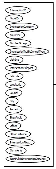
8 Intersection Attributes Intersection ID Node ID Intersection Category Area Type Number of Legs Traffic Control Type Lighting Milepost Latitude Longitude County City Ecoregion Terrain Skew Angle Offset & Offset Distance Distance to Next Public Intersection Data Parameters Leg Attributes 8 Leg ID SWLinkID Link ID Leg Number Intersection ID Leg Type Leg Route Type Leg Speed Leg Width Number of Lanes Number of Merge Lanes Pavement Type Orientation Median Type Median Width Leg Traffic Control Type Number of Left Turn Lanes Left Turn Lane Width Number of Right Turn Lanes Right Turn Lane Width Channelized Right Turn Right Turn Lane Movement Control Pedestrian Crossing Control One Way Turn Prohibitions Limited Sight Distance AADT PHV Ramp Terminal Attributes Intersection ID Ramp Speed Approaches within 250 ft Distance to Adjacent Ramp


9 Prototype Prototyped collection methodology on Desktop with Excel Collection Method: Pull from existing datasets Record descriptive data Measure Investigate using Street View 9
 Record skew to nearest whole degree Example: Skew Angle = 35 Θ Example: Node 12, McMullen, Pickens")
10 Intersection Skew Angle 10 1) Draw a triangle with legs of a representative length, following imagery of the road 2) Measure lengths of triangle legs 3) Calculate intersection angle using Law of Cosines 4) Record skew to nearest whole degree Example: Skew Angle = 35 Θ Example: Node 12, McMullen, Pickens County Θ=55
 Use the measure tool to record the offset distance Example: 11 Offset Distance= 19 feet Example: Node 180, Fayette, Fayette")
11 Intersection Offset and Offset Distance 1) Draw centerlines out from the middle of offset lanes 2) Draw a line to measure their distance apart 3) Use the measure tool to record the offset distance Example: 11 Offset Distance= 19 feet Example: Node 180, Fayette, Fayette County


12 Limited Sight Distance 12 Record left and right view obscurity for each possible turn maneuver Leg 3, Left, Not Limited Leg 4, Right, Limited Node 715, Cullman Co, Cullman Node 306, Jefferson Co, Leeds


13 Database Model Table Schema 13
14 GIS-Based Intersection Data Inventory Web Portal 14 Download to shapefile

15 GIS-Based Intersection Data Inventory Web Portal 15

16 Intersection Level Data 16


17 Draw and Measure Tools 17


18 Leg Level Data 18
19 Google Street View 19
20 Data Inventory Summary intersections of each type 270 intersections total 955 legs 20 minutes per intersection Data can be used for: Intersection statistics Correlations to crash data to identify possible locations for remediation


21 Data Inventory Statistics Frequency of Intersection Skew Angle in Ranges >=41 8% 9% 13% 16% 54% >=41 Presence of Lighting at Intersection and Area Type Number of Intersections % 73% 75% 25% 0 Rural Urban Lighting Present No Lighting 98 34


22 Data Inventory Statistics 22 Painted Lines 3% Grass 13% 2-way Left-turn Lane 6% Frequency of Median Types Other Divided 2% Undivided 76% Undivided Grass Painted Lines 2-way Leftturn Lane Other Divided Median Widths Std. Average Dev. Undivided 0 ft 0 ft Grass 43 ft 23 ft Painted Lines 15 ft 7 ft 2-way Leftturn Lane 15 ft 2 ft Other Divided 14 ft 5 ft
23 CARE Crash Dataset CARE: Critical Analysis Reporting Environment Center for Advanced Public Safety (CAPS) Dataset from Along mileposted routes (state, federal, interstate) 286,475 crashes Of those: 60.2% occur at intersection or are intersection related 23
24 Crash Data With a 600 foot buffer: 2,127 crash events near investigated intersections Spatial join to the 270 intersections Normalized number of crashes at each intersection by AADT Number of Crashes/1,000,000 vehicles 24
25 Number of Normalized Crashes/1,000,000 vehicles Skew Angle Analysis 25 Effect of Skew Angle on Crash Frequency Skew Angle


26 Number of Normalized Crashes/1,000,000 vehicles per Intersection Turn Lane Analysis No Turn Lanes Right Turn Lane Only Left Turn Lane Only Both Right and Left Turn Lanes Normalized Crashes Effect of Turn Lanes on Crash Frequency per Intersection
27 Conclusion 270 intersections in the data inventory 30 replicas of each intersection type for statistical representation Statewide Implementation level of effort is large Systematic approach for additional data 27 Starting with 100 worst intersections along state routes in the state Early stages of correlations with crash events We are seeing relationships with intersection characteristics and crashes Online GIS Based Intersection Data Inventory Web Portal Extensible to other states with transportation linear referencing systems
IHSDM- HSM Predictive Methods. Slide 1
 IHSDM- HSM Predictive Methods Slide 1 Presentation Outline IHSDM Overview Relationship between HSM and IHSDM Crash Prediction Models and Data Needs IHSDM HSM Predictive Method 2011 Release Preview Questions
Safety Assessment of Installing Traffic Signals at High-Speed Expressway Intersections
 Safety Assessment of Installing Traffic Signals at High-Speed Expressway Intersections Todd Knox Center for Transportation Research and Education Iowa State University 2901 South Loop Drive, Suite 3100
Vision Zero High Injury Network Methodology
 Vision Zero High Injury Network Methodology DATA SETS USED: 1. Reportable crashes in Philadelphia from 2012-2016, available as open data through PennDOT 2. Street Centerline geographic layer, maintained
General References Definitions. (1) Design Guidance. (2) Supporting Information
 Design Guidance. (2) Supporting Information") Chapter 1240 Turning Roadways 1240.01 General 1240.02 References 1240.03 Definitions 1240.04 Turning Roadway Widths 1240.05 Documentation 1240.01 General The roadway on a curve may need to be widened to
Chapter 1240 Turning Roadways 1240.01 General 1240.02 References 1240.03 Definitions 1240.04 Turning Roadway Widths 1240.05 Documentation 1240.01 General The roadway on a curve may need to be widened to
PERFORMANCE ACTIVITY 613 IMPACT ATTENUATOR WORK DESCRIPTION 3
 PERFORMANCE ACTIVITY 613 IMPACT ATTENUATOR WORK DESCRIPTION 1 WORK DESCRIPTION 2 WORK DESCRIPTION 3 Install Remove Repair 613 IMPACT ATTENUATOR ACTIVITY DESCRIPTION Repair, install, remove and maintain
Phase I-II of the Minnesota Highway Safety Manual Calibration. 1. Scope of Calibration
 TECHNICAL MEMORANDUM Phase I-II of the Minnesota Highway Safety Manual Calibration PREPARED FOR: PREPARED BY: Minnesota Department of Transportation Richard Storm, CH2M HILL Veronica Richfield, CH2M HILL
The major street is typically the intersecting street with greater traffic volume, larger cross-section, and higher functional class.
 INTERSECTIONS DESIGN Definitions and key elements An intersection is defined as an area where two or more roadways join or cross. Each roadway extending from the intersection is referred to as a leg. The
Geometric Categories as Intersection Safety Evaluation Tools
 Geometric Categories as Intersection Safety Evaluation Tools John R. Campbell Ayres Associates N19 W24075 Riverwood Drive, Suite 300 Waukesha, WI 53188 campbellj@ayresassociates.com Keith K. Knapp Engineering
Chapter 5 DATA COLLECTION FOR TRANSPORTATION SAFETY STUDIES
 Chapter 5 DATA COLLECTION FOR TRANSPORTATION SAFETY STUDIES 5.1 PURPOSE (1) The purpose of the Traffic Safety Studies chapter is to provide guidance on the data collection requirements for conducting a
PERFORMANCE ACTIVITY 306 DRAINAGE PIPE WORK DESCRIPTION 4
 PERFORMANCE ACTIVITY 306 DRAINAGE PIPE WORK DESCRIPTION 1 WORK DESCRIPTION 2 WORK DESCRIPTION 3 WORK DESCRIPTION 4 Repair Install Remove Clean 306 DRAINAGE PIPE ACTIVITY DESCRIPTION Install, repair, clean,
Access Management in the Vicinity of Intersections
 Access Management in the Vicinity of Intersections FHWA-SA-10-002 Technical Summary Photo: Ralph Bentley (used with permission) 0 Access Management is: The design, implementation and management of entry
PERFORMANCE ACTIVITY 405 LIMB MANAGEMENT
 PERFORMANCE ACTIVITY 405 LIMB MANAGEMENT 405 LIMB MANAGEMENT ACTIVITY DESCRIPTION Cut and/or remove and/or grind tree limbs from the right-of-way. TRAFFIC CONTROL Utilize intermittent mobile operations
PEDESTRIAN SAFETY IMPROVEMENT EVALUATION GUIDELINE FOR UNCONTROLLED CROSSINGS
 PEDESTRIAN SAFETY IMPROVEMENT EVALUATION GUIDELINE FOR UNCONTROLLED CROSSINGS Traffic Safety Engineering Division Updated: April 2018 EXECUTIVE SUMMARY NDOT Traffic Safety Engineering Division developed
1.3.4 CHARACTERISTICS OF CLASSIFICATIONS
 Geometric Design Guide for Canadian Roads 1.3.4 CHARACTERISTICS OF CLASSIFICATIONS The principal characteristics of each of the six groups of road classifications are described by the following figure
Safety Effectiveness of Pedestrian Crossing Treatments
 Portland State University PDXScholar TREC Friday Seminar Series Transportation Research and Education Center (TREC) 10-13-2017 Safety Effectiveness of Pedestrian Crossing Treatments Christopher Monsere
Performance-Based Approaches for Geometric Design of Roads. Douglas W. Harwood MRIGlobal 3 November 2014
 Performance-Based Approaches for Geometric Design of Roads Douglas W. Harwood MRIGlobal 3 November 2014 Traditional Approaches to Highway Geometric Design Based on established geometric design criteria
Bicycle - Motor Vehicle Collisions on Controlled Access Highways in Arizona
 Bicycle - Motor Vehicle Collisions on Controlled Access Highways in Arizona Analysis from January 1, 1991 to June 30, 2002 Richard C. Moeur, PE Traffic Design Manager, Northern Region Michelle N. Bina
FHWA Safety Performance for Intersection Control Evaluation (SPICE) Tool
 Tool") FHWA Safety Performance for Intersection Control Evaluation (SPICE) Tool Virginia Section ITE Annual Meeting Virginia Beach June 217 Pete Jenior Kittelson & Associates, Inc. 1 Intersection Control Evaluation
FHWA Safety Performance for Intersection Control Evaluation (SPICE) Tool Virginia Section ITE Annual Meeting Virginia Beach June 217 Pete Jenior Kittelson & Associates, Inc. 1 Intersection Control Evaluation
PERFORMANCE ACTIVITY 401 MOWING WORK DESCRIPTION 5
 PERFORMANCE ACTIVITY 401 MOWING WORK DESCRIPTION 1 WORK DESCRIPTION 2 WORK DESCRIPTION 3 WORK DESCRIPTION 4 WORK DESCRIPTION 5 Brush Management Hand Trimming Outdoor Advertising Window Routine Safety 401
INTERSECTIONS AT GRADE INTERSECTIONS
 INTERSECTIONS 1 AT GRADE INTERSECTIONS INTERSECTIONS INTERSECTIONS = INTERRUPTED FACILITIES Definitions and key elements An intersection is defined as an area where two or more roadways join or cross.
Highway Project Scoring Worksheet Project Name: Ike Brooks Rd/Rives Chapel Church Rd Improvements (SPOT ID: H090571)
") Highway Project Scoring Worksheet Project Name: Ike Brooks Rd/Rives Chapel Church Rd Improvements (SPOT ID: H9571) COUNTY RANK SCORING (5% of total) Countywide Ranking (1 points maximum) Enter ranking
Highway Project Scoring Worksheet Project Name: Ike Brooks Rd/Rives Chapel Church Rd Improvements (SPOT ID: H9571) COUNTY RANK SCORING (5% of total) Countywide Ranking (1 points maximum) Enter ranking
Analysis of Run-Off-Road Crashes in Relation to Roadway Features and Driver Behavior
 Analysis of Run-Off-Road Crashes in Relation to Roadway Features and Driver Behavior Ertan Örnek University of Wisconsin, Madison Traffic Operations Lab 141 NW Barstow Street Waukesha, WI 53187 ornek@wisc.edu
MONROE COUNTY NEW YORK
 MONROE COUNTY NEW YORK Intersection Accident Database Enhancement Project (UPWP 4380) FINAL January 2008 Prepared By: Prepared For: Bergmann Associates 200 First Federal Plaza 28 East Main Street Rochester,
Safety at Unsignalized Intersections. Unsignalized Intersections
 Safety at FHWA Safety Focus Areas 2 National Statistics 3 National Statistics There were 41,059 highway fatalities in 2007. Where did they occur? Non-Intersections 79% About half of all crashes and half
Development of Criteria to Identify Pedestrian High Crash Locations in Nevada. Quarterly Progress Report. Submitted to
 Development of Criteria to Identify Pedestrian High Crash Locations in Nevada Submitted to Nevada Department of Transportation (NDOT) Research Division 1263 South Stewart Street Carson City, NV 89712 Krishna
TRAFFIC AND SAFETY NOTE 608A. Spacing for Commercial Drives and Streets. To Promote a Uniform Practice in Determining Access Spacing
 TRAFFIC AND SAFETY NOTE 608A SUBJECT: PURPOSE: Spacing for Commercial Drives and Streets To Promote a Uniform Practice in Determining Access Spacing COORDINATING UNIT: Geometric Design Unit INFORMATION:
Statewide Access Management Coordination GoToWebinar
 Statewide Access Management Coordination GoToWebinar Promoting innovative, efficient, and exceptional work since 1988 April 26, 2017 ( 2:30 EST, 1:30 CST) Answers to Common Questions Yes we will provide
Crash Data Analysis for Converting 4-lane Roadway to 5-lane Roadway in Urban Areas
 Crash Data Analysis for Converting 4-lane Roadway to 5-lane Roadway in Urban Areas Xiaoduan Sun, University of Louisiana at Lafayette Nicholas P. Fruge, LADOTD District 3 Subasish Das, University of Louisiana
Background on the Revisions to VDOT s Access Management Spacing Standards
 December 2011 Background on the Revisions to VDOT s Access Management Spacing Standards Spacing Standards for Commercial Entrances, Signals, Intersections, and Crossovers The spacing standards were located
Topic No January 2000 Manual on Uniform Traffic Studies Revised July Chapter 8 GAP STUDY
 Chapter 8 8.1 PURPOSE GAP STUDY (1) The Gap Study is used to determine the size and the number of gaps in the vehicular traffic stream for unsignalized intersections and access points, pedestrian studies,
Florida s Intersection Safety Implementation Plan (ISIP)
") Florida Department of TRANSPORTATION Florida s Intersection Safety Implementation Plan (ISIP) Alan El-Urfali, PE State Traffic Engineering and Operations Office March 28, 2017 Intersection Safety Implementation
Florida Department of TRANSPORTATION Florida s Intersection Safety Implementation Plan (ISIP) Alan El-Urfali, PE State Traffic Engineering and Operations Office March 28, 2017 Intersection Safety Implementation
DEFINITIONS Activity Area - Advance Warning Area Advance Warning Sign Spacing Advisory Speed Approach Sight Distance Attended Work Space
 DEFINITIONS Activity Area - that part of a TTC zone activity area where the work actually takes place. It consists of the work space, traffic space and one or more buffer spaces. Advance Warning Area -
RURAL HIGHWAY SHOULDERS THAT ACCOMMODATE BICYCLE AND PEDESTRIAN USE (TxDOT Project ) June 7, Presented by: Karen Dixon, Ph.D., P.E.
 June 7, Presented by: Karen Dixon, Ph.D., P.E.") RURAL HIGHWAY SHOULDERS THAT ACCOMMODATE BICYCLE AND PEDESTRIAN USE (TxDOT Project 0-6840) June 7, 2016 Presented by: Karen Dixon, Ph.D., P.E., TTI Team: Kay Fitzpatrick, Raul Avelar, & Subasish Das Project
RURAL HIGHWAY SHOULDERS THAT ACCOMMODATE BICYCLE AND PEDESTRIAN USE (TxDOT Project 0-6840) June 7, 2016 Presented by: Karen Dixon, Ph.D., P.E., TTI Team: Kay Fitzpatrick, Raul Avelar, & Subasish Das Project
Safety Impacts: Presentation Overview
 Safety Impacts: Presentation Overview The #1 Theme How Access Management Improves Safety Conflict Points The Science of Access Management By Treatment Studies Themes for Texas Access Management Improve
CE576: Highway Design and Traffic Safety
 CE576: Highway Design and Traffic Safety Predicting Crash Frequency for Two-Lane Rural Highway Segments Cross Sectional Elements Ahmed Abdel-Rahim, Ph.D., P.E. Civil Engineering Department University of
HSM Practitioners Guide to Urban and Suburban Streets. Prediction of Crash Frequency for Suburban/Urban Streets
 HSM Practitioners Guide to Urban and Suburban Streets Prediction of Crash Frequency for Suburban/Urban Streets Predicting Crash Frequency of Suburban/Urban Multilane Streets Learning Outcomes: Describe
Basic Freeways and Multilane Highways (LOS) CIVL 4162/6162
 CIVL 4162/6162") Basic Freeways and Multilane Highways (LOS) CIVL 4162/6162 Learning Objectives Define uninterrupted facilities Determine LOS of Basic freeway segments Multilane highways Uninterrupted Flow Facilities Pure
Basic Freeways and Multilane Highways (LOS) CIVL 4162/6162 Learning Objectives Define uninterrupted facilities Determine LOS of Basic freeway segments Multilane highways Uninterrupted Flow Facilities Pure
VDOT Crash Analysis Procedures for Roadway Safety Assessments
 Crash analysis is a critical component of road safety analysis. The crash analysis procedures defined in this document will help: Identify where to target resources for detailed crash analysis Assess the
Preliminary Findings for Texas s North Central Texas Council of Governments Region
 Texas Intersection Safety Implementation Plan Preliminary Findings for Texas s North Central Texas Council of Governments Region March 30, 2016 Revised June 15, 2016 Introduction The overall objective
Chapter 4 Traffic Analysis
 Chapter 4 Traffic Analysis PURPOSE The traffic analysis component of the K-68 Corridor Management Plan incorporates information on the existing transportation network, such as traffic volumes and intersection
WYDOT DESIGN GUIDES. Guide for. Non-NHS State Highways
 WYDOT DESIGN GUIDES Guide for Non-NHS State Highways 2014 GUIDE FOR Non-NATIONAL HIGHWAY SYSTEM (Non-NHS) STATE HIGHWAYS PRESERVATION REHABILITATION RECONSTRUCTION INTRODUCTION This Guide is directed to
SAFETY ANALYSIS OF DRIVEWAY CHARACTERISTICS IN SOUTH CAROLINA USING GIS. Wayne A. Sarasua Kweku Brown
 SAFETY ANALYSIS OF DRIVEWAY CHARACTERISTICS IN SOUTH CAROLINA USING GIS Wayne A. Sarasua Kweku Brown Overall Goal The overall goal of this project is to enhance SCDOT s current access management practices
Intersection Safety 6/7/2015 INTERSECTIONS. Five basic elements should be considered in intersection design. Intersection Safety (continued)
") Intersection Safety S. M. SOHEL MAHMUD Assistant Professor Accident Research Institute (ARI), Bangladesh University of Engineering and Technology (BUET) Dhaka-1000, Bangladesh 1 Outline of the Presentation
Intersection Safety S. M. SOHEL MAHMUD Assistant Professor Accident Research Institute (ARI), Bangladesh University of Engineering and Technology (BUET) Dhaka-1000, Bangladesh 1 Outline of the Presentation
Analyzing Spatial Patterns, Statistics Based on FAST Act Safety Performance Measures
 Analyzing Spatial Patterns, Statistics Based on FAST Act Safety Performance Measures Abhishek Bhargava, PhD April 13, 2017 Agenda Objective Highway Safety Improvement Program (HSIP) & FAST Act Performance
Figure 3B-1. Examples of Two-Lane, Two-Way Marking Applications
 Figure 3B-1. Examples of Two-Lane, Two-Way Marking Applications A - Typical two-lane, two-way marking with passing permitted in both directions B - Typical two-lane, two-way marking with no-passing zones
Texas Intersection Safety Implementation Plan Workshop JUNE 2, 2016
 Texas Intersection Safety Implementation Plan Workshop JUNE 2, 2016 Why Intersection Safety? A small part of overall highway system, but Each year roughly 50% of all crashes estimated 3 million involve
CHAPTER 1 STANDARD PRACTICES
 CHAPTER 1 STANDARD PRACTICES OBJECTIVES 1) Functions and Limitations 2) Standardization of Application 3) Materials 4) Colors 5) Widths and Patterns of Longitudinal Pavement Marking Lines 6) General Principles
CHAPTER 6H. TYPICAL APPLICATIONS
 Section 6H.01 Typical Applications Support: CHAPTER 6H. TYPICAL APPLICATIONS Chapter 6G contains discussions of typical temporary traffic control activities. Chapter 6H presents typical applications for
CROSSING GUARD PLACEMENT CONSIDERATIONS AND GAP ASSESSMENT
 CROSSING GUARD PLACEMENT CONSIDERATIONS AND GAP ASSESSMENT Many factors contribute to the need for a Crossing Guard. General federal guidance, provided by the FHWA MUTCD, states that adult crossing guards
Guidelines for Integrating Safety and Cost-Effectiveness into Resurfacing, Restoration, and Rehabilitation Projects
 Guidelines for Integrating Safety and Cost-Effectiveness into Resurfacing, Restoration, and Rehabilitation Projects NCHRP Project 15-50 July 2017 1 Research Objective Develop guidelines for safe and cost-effective
Relationship of Road Lane Width to Safety for Urban and Suburban Arterials
 Relationship of Road Lane Width to Safety for Urban and Suburban Arterials Phd. Alma AFEZOLLI Polytechnic University of Tirana Construction and Infrastructure Department of Civil Engineering Faculty Tirana,
Evaluating Road Departure Crashes Using Naturalistic Driving Study Data
 Evaluating Road Departure Crashes Using Naturalistic Driving Study Data Strategic Highway Research Program 2 Transportation Research Board Third Safety Research Symposium July 17 & 18, 2008 Research Team:
Designing for Pedestrians: An Engineering Symposium. Rutgers University March 21, 2013
 Designing for Pedestrians: An Engineering Symposium Rutgers University March 21, 2013 The Problem 2 Pedestrian Fatalities Pedestrian Fatalities by Year in US (1994-2010) 6000 5000 4000 3000 2000 1000 0
Traffic Records Forum Noteworthy State Safety Roadway Data Programs
 Traffic Records Forum Noteworthy State Safety Roadway Data Programs 1 WISCONSIN INFORMATION SYSTEMS FOR LOCAL ROADS THE EVOLUTION OF WISCONSIN LOCAL ROADS SYSTEM TO SUPPORT SAFETY DATA DRIVEN DECISION-MAKING
Lessons Learned from the Minnesota County Road Safety Plans. Richard Storm CH2M HILL
 Lessons Learned from the Minnesota County Road Safety Plans Richard Storm CH2M HILL May 21, 2014 Overview of the MN CRSP: Why Prepare Safety Plans for Local Systems? MAP-21: Requires states to address
Evaluation of Interactive Highway Safety Design Model Crash Prediction Tools for Two-Lane Rural Roads on Kansas Department of Transportation Projects
 Report No. K-TRAN: KU-10-1 FINAL REPORT November 2013 Evaluation of Interactive Highway Safety Design Model Crash Prediction Tools for Two-Lane Rural Roads on Kansas Department of Transportation Projects
ENHANCED PARKWAY STUDY: PHASE 2 CONTINUOUS FLOW INTERSECTIONS. Final Report
 Preparedby: ENHANCED PARKWAY STUDY: PHASE 2 CONTINUOUS FLOW INTERSECTIONS Final Report Prepared for Maricopa County Department of Transportation Prepared by TABLE OF CONTENTS Page EXECUTIVE SUMMARY ES-1
Safety of U-Turns at Unsignalized Median Openings on Urban and Suburban Arterials
 Safety of U-Turns at Unsignalized Median Openings on Urban and Suburban Arterials Ingrid B. Potts Herbert S. Levinson Senior Traffic Engineer Transportation Consultant Midwest Research Institute 40 Hemlock
ALLEY 24 TRAFFIC STUDY
 ALLEY 24 TRAFFIC STUDY in City of Frostburg, Maryland January 2013 3566 Teays Valley Road Hurricane, WV Office: (304) 397-5508 www.denniscorporation.com Alley 24 Traffic Study January 2013 Frostburg, Maryland
An Investigation of Longitudinal Pavement Marking Retroreflectivity and Safety
 An Investigation of Longitudinal Pavement Marking Retroreflectivity and Safety FHWA Final Report Paul J. Carlson Eun Sug Park Dong Hun Kang Texas Transportation Institute March 18, 2014 1 INTRODUCTION
Access Management Regulations and Standards
 Access Management Regulations and Standards January 2014 Efficient highway operation Reasonable property access Concept of Access Management The way to manage access to land development while preserving
Crash Reduction Factors. Desktop Reference. for. Federal Highway Administration. U.S. Department of Transportation. Publication No.
 Desktop Reference for Reduction Factors U.S. Department of Transportation Federal Highway Administration Publication No. FHWA-SA-07-015 September 2007 THIS PAGE LEFT INTENTIONALLY BLANK Notice This document
Multimodal Design Guidance. October 23, 2018 ITE Fall Meeting
 Multimodal Design Guidance October 23, 2018 ITE Fall Meeting Introductions Jessica Wilson TDOT Multimodal Division Office of Multimodal Planning Program Supervisor Jessica.L.Wilson@tn.gov Ali Hangul TDOT
Title of the proposed project Development of a Toolbox for Evaluation and Identification of Urban Road Safety Improvement Measures
 Centre of Excellence (CoE) in Urban Transport Department of Civil Engineering, IIT Madras Title of the proposed project Development of a Toolbox for Evaluation and Identification of Urban Road Safety Improvement
Chapter Twenty-eight SIGHT DISTANCE BUREAU OF LOCAL ROADS AND STREETS MANUAL
 Chapter Twenty-eight SIGHT DISTANCE BUREAU OF LOCAL ROADS AND STREETS MANUAL Jan 2006 SIGHT DISTANCE 28(i) Chapter Twenty-eight SIGHT DISTANCE Table of Contents Section Page 28-1 STOPPING SIGHT DISTANCE
Traffic Accident Data Processing
 Traffic Accident Data Processing D o n a l d F. P e t t y Engineer of Traffic Research and Surveys Indiana State Highway Commission The following is a portion of the Highway Safety Program Standards developed
J-Turn An Intersection Safety Improvement Purdue Road School 2016 Tuesday, March 8, 2016 Brian Malone, INDOT & Josh Cook, HNTB
 J-Turn An Intersection Safety Improvement Purdue Road School 2016 Tuesday, March 8, 2016 Brian Malone, INDOT & Josh Cook, HNTB US 231 and SR 62 and SR 68 US 231 and SR 62 Intersection Traffic Data Traffic
Chapter 8 Chapter 8 VEHICLE GAP STUDY PURPOSE VEHICLE GAP STUDY (FIGURE 8-1)
") Chapter 8 Chapter 8 Formatted: Heading 1 VEHICLE GAP STUDY 5.48.18.1 PURPOSE (1) The Vehicle Gap Study (Form No. 750-020-08) is used to determine the size and the number of gaps in the vehicular traffic
Chapter 8 Chapter 8 Formatted: Heading 1 VEHICLE GAP STUDY 5.48.18.1 PURPOSE (1) The Vehicle Gap Study (Form No. 750-020-08) is used to determine the size and the number of gaps in the vehicular traffic
CHAPTER 6H. TYPICAL APPLICATIONS
 2006 Edition Page 6H-1 CHAPTER 6H. TYPICAL APPLICATIONS Section 6H.01 Typical Applications Support: Whenever the acronym TTC is used in this Chapter, it refers to temporary traffic control. Standard: The
4/27/2016. Introduction
 EVALUATING THE SAFETY EFFECTS OF INTERSECTION SAFETY DEVICES AND MOBILE PHOTO ENFORCEMENT AT THE CITY OF EDMONTON Karim El Basyouny PhD., Laura Contini M.Sc. & Ran Li, M.Sc. City of Edmonton Office of
TRAFFIC SIGNAL WARRANT SUMMARY
 Level 1. Is the critical speed of major street traffic > 7 km/h (4 mph)? Yes No 2. Is the intersection in a built-up area of isolated community of
FINAL REPORT - Revised from original submittal -
 FINAL REPORT - Revised from original submittal - Comparing Street Lighting Levels with Nighttime Crash Histories -VOLUME I- Submitted to: Florida Department of Transportation District 7 11201 N Malcolm
1 VicRoads Access Management Policies May 2006 Ver VicRoads Access Management Policies May 2006 Version 1.02
 1 VicRoads Access Management Policies May 2006 Ver 1.02 VicRoads Access Management Policies May 2006 Version 1.02 2 VicRoads Access Management Policies May 2006 Ver 1.02 FOREWORD FOR ACCESS MANAGEMENT
Recently Developed Intersection CMFs. Nancy Lefler, VHB ATSIP Traffic Records Forum, 2014
 Recently Developed Intersection CMFs Nancy Lefler, VHB ATSIP Traffic Records Forum, 2014 Overview General Methodology Treatments Installation of traffic signals - with and without left-turn lanes (NCDOT)
Chapter 7 Intersection Design
 hapter 7 Dr. Yahya Sarraj Faculty of Engineering The Islamic University of Gaza An intersection is an area, shared by two or more roads, whose main function is to provide for the change of route directions.
Missouri Highway Safety Manual Recalibration
 Missouri Highway Safety Manual Recalibration Final Report May 2018 Sponsored by Missouri Department of Transportation Midwest Transportation Center U.S. Department of Transportation Office of the Assistant
Road Surface Characteristics and Accidents. Mike Mamlouk, Ph.D., P.E. Arizona State University
 Road Surface Characteristics and Accidents Mike Mamlouk, Ph.D., P.E. Arizona State University Factors Affecting Accident Rate Human factors Vehicular causes Environmental conditions Roadway geometry Traffic
Chapter 2B. REGULATORY SIGNS
 Chapter 2B. REGULATORY SIGNS TABLE OF CONTENTS Chapter 2B. Regulatory Signs Page Section 2B.1 Application of Regulatory Signs............................................ 2B-1 2B.2 Design of Regulatory
Safety Evaluation at Innovative Geometric Designs Gilbert Chlewicki, PE Advanced Transportation Solutions
 2016 ITE Mid-Colonial District Annual Conference Wilmington, Delaware Safety Evaluation at Innovative Geometric Designs Gilbert Chlewicki, PE Advanced Transportation Solutions April 18, 2016 WHY INNOVATIVE
Intersection Traffic Control Feasibility Study
 Intersection Traffic Control Feasibility Study CSAH 9 at CSAH 60 (185th Avenue) Prepared For: Dakota County Transportation Department Western Service Center 14955 Galaxie Avenue, 3rd Floor Apple Valley,
Pavement Markings (1 of 3)
") Pavement Markings (1 of 3) DESCRIPTION AND DEFINITION Disadvantages Relatively high cost (over typical Crash reduction as yet unknown painted edge line) No tactile effect The STOP AHEAD pavement marking
Pavement Markings (1 of 3) DESCRIPTION AND DEFINITION Disadvantages Relatively high cost (over typical Crash reduction as yet unknown painted edge line) No tactile effect The STOP AHEAD pavement marking
To Illuminate or Not to Illuminate: Roadway Lighting as It Affects Traffic Safety at Intersections
 To Illuminate or Not to Illuminate: Roadway Lighting as It Affects Traffic Safety at Intersections Mark Rea Lighting Research Center Rensselaer Polytechnic Institute Eric Donnell Dept. of Civil and Environmental
Access Management Regulations and Standards
 Access Management Regulations and Standards Efficient highway operation Reasonable property access Concept of Access Management The way to manage access to land development while simultaneously preserving
Traffic Engineering and Highway Safety Bulletin June Overview
 Traffic Engineering and Highway Safety Bulletin 18-03 June 2018 INTERSECTION GEOMETRIC DESIGN In This Issue Overview... 1 Intersection Types... 2 Traffic Control Selection... 3 Capacity Analysis... 6 Design
NCHRP Improved Prediction Models for Crash Types and Crash Severities. Raghavan Srinivasan UNC Highway Safety Research Center
 1 NCHRP 17-62 Improved Prediction Models for Crash Types and Crash Severities Raghavan Srinivasan UNC Highway Safety Research Center 2 The Project Team University of Connecticut Persaud & Lyon, Inc. University
Highway 49, Highway 351 and Highway 91 Improvements Feasibility Study Craighead County
 Highway 49, Highway 351 and Highway 91 Improvements Feasibility Study Craighead County Executive Summary March 2015 Highway 49, Highway 351 and Highway 91 Improvements Feasibility Study Craighead County
Desktop Reference for Crash Reduction Factors
 Page 68 Desktop Reference for Crash Reduction Factors Report No. FHWA-SA-07-015 U.S. Department of Transportation Federal Highway Administration September 2007 Page 69 THIS PAGE LEFT INTENTIONALLY BLANK
SHRP 2. Strategic Highway Research Program. Accelerating solutions for highway safety and performance. Charles Fay, Sr.
 Strategic Highway Research Program SHRP 2 Accelerating solutions for highway safety and performance Charles Fay, Sr. Program Officer GIS-T Boise, ID 2013 Second Strategic Highway Research Program ( SHRP
Figure 1: Graphical definitions of superelevation in terms for a two lane roadway.
 Iowa Department of Transportation Office of Design Superelevation 2A-2 Design Manual Chapter 2 Alignments Originally Issued: 12-31-97 Revised: 12-10-10 Superelevation is the banking of the roadway along
Access Location, Spacing, Turn Lanes, and Medians
 Design Manual Chapter 5 - Roadway Design 5L - Access Management 5L-3 Access Location, Spacing, Turn Lanes, and Medians This section addresses access location, spacing, turn lane and median needs, including
Desktop Reference for Crash Reduction Factors
 Desktop Reference for Reduction Factors Report No. FHWA-SA-08-011 U.S. Department of Transportation Federal Highway Administration September 2008 THIS PAGE LEFT INTENTIONALLY BLANK Notice This document
CURRENT ORIGINAL REFERENCE SECTIONS. (Typical Section) (Typical Section) The Parade Island Bay : Concept Option Summary Sheets.
 (Typical Section) The Parade Island Bay : Concept Option Summary Sheets.") ORIGINAL (Typical Section) CURRENT (Typical Section) 3,900 3,000 2,000 1,500 3,100 1,600 3,100 1,500 2,000 2,500 3,900 3,000 1,800 600 2,000 3,000 3,000 2,000 600 1,800 2,500 Existing Planting Traffic
ORIGINAL (Typical Section) CURRENT (Typical Section) 3,900 3,000 2,000 1,500 3,100 1,600 3,100 1,500 2,000 2,500 3,900 3,000 1,800 600 2,000 3,000 3,000 2,000 600 1,800 2,500 Existing Planting Traffic
Multilane Roundabouts
 Multilane Roundabouts Supplement to Synchro 7 Studio Users Guide Discussion SimTraffic 7 has been updated to better model multilane roundabouts. With the new logic it is possible to model a two-lane arterial
Safety of U-turns at Unsignalized Median Openings
 Safety of U-turns at Unsignalized Median Openings Ingrid Potts Midwest Research Institute Kansas City, MO August 31, 2004 Douglas W. Harwood Co-Authors Midwest Research Institute Herbert S. Levinson Transportation
WYDOT DESIGN GUIDES. Guide for. NHS Arterial (Non-Interstate)
") WYDOT DESIGN GUIDES Guide for NHS Arterial (Non-Interstate) 2014 GUIDE FOR NATIONAL HIGHWAY SYSTEM (NHS) HIGHWAYS (NHS ARTERIALS, Non-Interstate) PRESERVATION REHABILITATION RECONSTRUCTION INTRODUCTION
WYDOT DESIGN GUIDES Guide for NHS Arterial (Non-Interstate) 2014 GUIDE FOR NATIONAL HIGHWAY SYSTEM (NHS) HIGHWAYS (NHS ARTERIALS, Non-Interstate) PRESERVATION REHABILITATION RECONSTRUCTION INTRODUCTION
Closing Plenary Session
 TRAFFIC SAFETY CONFERENCE Closing Plenary Session June 9, 2017 Las Colinas, TX Order of Report Out June 9, 2017 Las Colinas, TX Distracted Driving Prioritized Countermeasures Countermeasure 4a Systemically
Management of Multi-Lane Highways in Jordan (Case Study)
") Management of Multi-Lane Highways in Jordan (Case Study) Basim Jrew 1), Nidal Hussein 2) and Rami Al-Kouz 3) 1) Isra University, Jordan. E-Mail: basim.jrew@iu.edu.jo 2) Isra University, Jordan. E-Mail:
Management of Multi-Lane Highways in Jordan (Case Study) Basim Jrew 1), Nidal Hussein 2) and Rami Al-Kouz 3) 1) Isra University, Jordan. E-Mail: basim.jrew@iu.edu.jo 2) Isra University, Jordan. E-Mail:
CHAPTER 2 LITERATURE REVIEW
 CHAPTER 2 LITERATURE REVIEW 2.1 Introduction This chapter presents some background information of the available literature related to the development of accident rates, accident models and accident statistic
Defining Purpose and Need
 Advanced Design Flexibility Pilot Workshop Session 4 Jack Broz, PE, HR Green May 5-6, 2010 Defining Purpose and Need In your agency s project development process, when do design engineers typically get
A Diet that Works AMATS Road Diet Analysis
 A Diet that Works AMATS Road Diet Analysis Curtis Baker, Planning Administrator David Pulay, Transportation Engineer October 2015 Overview What is a Road Diet? The Big Picture Why does an MPO care about