CONCEPTUAL PLANNING REPORT CONCEPTUAL MASTER PLAN WHITEWATER COURSE BARREN RIVER BOWLING GREEN, KENTUCKY
|
|
|
- Merry Ryan
- 5 years ago
- Views:
Transcription

1 CONCEPTUAL PLANNING REPORT CONCEPTUAL MASTER PLAN WHITEWATER COURSE BARREN RIVER BOWLING GREEN, KENTUCKY PREPARED BY: RECREATION ENGINEERING AND PLANNING 485 ARAPAHOE AVE. BOULDER, CO
 a brief site profile that includes a synopsis of the current site status, flows and hydraulic issues in the Barren River as well as planning and safety issues.")
2 Abstract This report evaluates opportunities for a whitewater park in Bowling Green, Kentucky on the Barren River. The report includes a) a brief site profile that includes a synopsis of the current site status, flows and hydraulic issues in the Barren River as well as planning and safety issues. The report also includes b) a brief overview of uses and users of the whitewater park and the constraints associated with these users as they apply to the plan of a whitewater park. Finally, this report includes c) a conceptual plan and cost estimate that represents a feasible solution for the Bowling Green Whitewater Park as defined by the constraints identified in a and b above. Introduction Whitewater sports are among the fastest growing recreational activities in North America. The recent trend among some cities to create whitewater parks has brought this sport from its traditional remote location to a more urban environment. Numerous whitewater parks have been constructed in North America and these parks, surrounded by trails, picnicking and recreational areas, have surpassed their original objective of attracting paddle sports enthusiasts and have become focal points for their communities. These parks attract visitors and locals alike and often play host to major events centered around slalom or freestyle kayaking competitions. Some towns, like the City of Golden, Colorado, have reported millions of dollars worth in impact on the local economy due to tourist activity attracted by their whitewater park. The purpose of this project is to develop a for a whitewater park along the waterfront development of the Barren River in Bowling Green, Kentucky. 3

3 This whitewater park would take advantage of the head and flows available at the Bowling Green Municipal Utilities (BGMU) Dam at the waterworks facility. The Conceptual Master Plan would integrate the Barren River with the city s waterfront by making a strong connection between people, the city neighborhoods and the downtown waterfront. The Barren River whitewater park would be an integral part of the fabric of the community and would become a citywide resource and attraction that is linked to the daily work, recreation and leisure life of both the inhabitants and visitors to Bowling Green. The primary vision is that the river would become an important asset and shared recreational, economic and environmental resource to the fullest extent possible. The planning process is then tasked with three primary objectives during this conceptual phase. The first objective is to gather sufficient information to understand site constraints associated with a whitewater park at this location. These constraints include access, hydrology, layout, and other physical constraints associated with the site. Also included in this task will be any constraints associated with other current uses of the river. The second phase involves identifying community constraints associated with this project. These include a complete understanding of the potential users and uses of the proposed whitewater park. Finally, the third objective of this document is to propose a conceptual planning solution that best provides for the constraints identified in this report. Site Profile: Bowling Green Municipal Utilities Waterworks Dam Site Bowling Green is located in South Central Warren County, Kentucky. The area of study is located along the Barren River at River Mile 37.6 from its confluence with the Green River. The importance of this corridor as a recreational and natural resource has been enhanced with the establishment of the River Walk at Mitch McConnell Park, which parallels a majority of the corridor length. 4


4 The river channel at this location features high banks with selected access points and, at some levels, trail access along the river by way of a trail on river right. The river channel features earthen and loose sandstone banks that are, for a large part of the reach, armored with small riprap at lower levels and are largely eroded above the low water line. The upper banks of the river feature regions that are steep embankments as well as other regions that are thickly forested. The streambed is sandy with some rocks and downed trees as well as numerous remnants of past in-stream development. The most prevalent of these remnants is the Waterworks Weir Structure at the head of the reach. This Structure is constructed of loose rock with an apparent (by inspection) d 50 of roughly ft. The dam features a static drop of approximately 10 feet. Upstream of this Structure is the City s municipal intake which, presumably, suffers from the decreased head caused by the erosion of the current dam structure. The reach also features three bridges of significance. Two hundred fifty feet downstream of the dam is the KY 3225 Old Louisville Road Bridge. This bridge rests on three pylons that are in the river channel. Eight hundred feet downstream of the dam, the second bridge is the Historic College Street Bridge that has now been converted into a pedestrian crossing. The bridge sits on a single mid-stream pylon and provides direct trail access to Mitch McConnell Park. Fifteen hundred feet downstream of the waterworks dam is the US 68 Louisville Road/ N/X Corridor Bridge, which sits on 5
5 two pylons. The last bridge is 1,650 feet downstream of the dam. This is a single track CSX Railroad bridge. Access to the site is prevalent, but is made difficult by the elevation difference between the river and the City, which sits high on the Barren River s steep banks. At present, there is a greenway and the aforementioned park directly adjacent to the selected reach of the river. Additionally, current master plans call for dramatic enhancement of the river s banks on the river right side. This enhancement would create open access directly to the water s edge. One of the key elements of the proposed whitewater course would need to be integration of the proposed whitewater park with the current master plan for this property. There are several physical constraints associated with this reach of the river. The existing dam provides head for the City s water works. This head elevation would need to be maintained at all flows in order to ensure ample flow depth for this facility. Additionally, there are, as mentioned above, several bridge pylons within this reach. Planning of the water park would need to include scour analysis of the final plan in order to ensure the continued stability of these pylons. Additionally, the shape of the pylons and the direction of the flow would need to be tailored such that the pylons do not create an in-stream hazard to the boaters who visit the park. Flow Characteristics Peak flows for the Barren River in Bowling Green, Kentucky are shown in Figure 1. Analysis of available peak streamflows, shown in Figure 1, suggests that peak flows in the Barren River are extremely high. While an upstream dam acts to somewhat dampen flooding, the estimated 100 year flood level for this reach is 62,300 cfs 1. This is an extremely high flood flow. Planning and modeling would need to account for both flood elevations and flood power. 1 Source: Jamie Blanton, USACE, Louisville District. Study dated 1994 based on flows from Estimated flood discharge adjusted to include effects of dam. 6
6 Figure 1. Peak stream flows for the Barren River in Bowling Green (Source, usgs.gov) Average flows, however, are much more manageable. Peak average flows occur in the winter months and can reach, on average, levels in the cfs range. Low average flows occur in the summer and can be as low as cfs on average. Figure 2 shows the average mean of monthly streamflows for the Barren River in Bowling Green, Kentucky (source: USGS gauge ). 7
7 Average Mean of Monthly Streamflows cfs Jan Feb Mar Apr May Jun Jul Aug Sep Oct Nov Dec Figure 2. Average Mean of Monthly Stream flows for Barren River in Bowling Green. Figure 2 illustrates the average mean of monthly streamflows. It should be noted that these flows are substantial and, in combination with the gradient seen at the sites listed above, can be used to create a very attractive whitewater park. Minimum flows commensurate with the summer levels should be used to tailor the width and depth of low flow channels. The summer season can be expected to be the height of the tourist season so special consideration should be given to tailoring attractive whitewater features to these levels. Ideal levels are difficult to target given the large month to month variability of flow levels. Plans should be created that are extremely versatile with respect to flow rates, thus taking advantage of the low summer flows while still providing play attractive play features during the winter months. 8

8 Project Planning Project planning for this type of whitewater park is a key element of the planning process. It is necessary to have a complete understanding of the project, its users, and the city s intended objectives before planning begins. The park is intended to be an open access facility that is integrated with the River Walk and Mitch McConnell Park expansion. The whitewater improvements are tasked with providing a downtown in-stream recreational amenity that is an attraction to local users as well as visitors and destination paddlers. The plan is further tasked with creating a facility that can host competitive and recreational events at a national level while still providing unintimidating recreation for all levels of boaters. The park should also serve as an aesthetic attraction and should provide streamside recreation, seating, and shade for non-boating visitors. A user analysis has been prepared in order to gain insight into the constraints associated with each of these types of users. A summary of these typical users is listed below: 2 2 This summary of users represents assumptions made with regard to a spectrum of typical users for whitewater parks throughout the world and was not created from a public process survey. Such a survey is not in the purview of this study. 9
9 Whitewater Park User Groups From a planning standpoint, the User Groups include all of the entities that are involved in successfully implementing the operational model for the park. The following groups have been identified as likely users of the whitewater course: The City of Bowling Green; Local whitewater clubs; Rafters; Recreational boaters; Top-level boaters; and Spectators. Amplifying information on these groups is presented below. The City of Bowling Green, Kentucky The City represents the initial owner and operators of the Barren River whitewater park. The City is seeking both a recreational amenity as well as a tourist attraction that would help drive the local economy. On the flip side, the City is seeking a facility that is both easy and cheap to maintain and does not create an increased flood risk. The City is very interested in seeing the plan of the park mesh seamlessly with the River Walk expansion in order to maximize their investment. Additionally, the City does not want to see any effect on their municipal operations. Associated Planning Criteria: The whitewater park should serve as an amenity for both local and visiting users. Maintenance costs should be minimized. The whitewater improvements must not affect the City s municipal operations. The site should be appropriate for competitive events that showcase the water park to the community on a local basis and the community to the Nation in the media and press. 10
10 Local Whitewater Clubs The local whitewater clubs and specialty shops (which include West Kentucky University s Physical Education and Recreation Department and Outdoor Recreation Adventure Center) also have an interest in the whitewater park. Perhaps the central and primary purpose of the park would be to provide an easy access centrally located park and play destination that can be accessed quickly from the town and provide top quality recreation with very little time commitment. These users are looking for a local recreational amenity as well as a venue to host competitive events. Furthermore, the park should help grow the sport in the local region by providing instructional facilities for beginners, clubs and classes as well as training facilities for developing athletes who wish to practice and compete at the site. Perhaps the central and primary purpose of the park would be to provide an easy access centrally located park and play destination that can be accessed quickly from the town and provide top quality recreation with very little time commitment. Associated Planning Criteria: The course must provide world-class whitewater in an attractive setting. The course must provide a quality experience to as many users as possible. The course must accommodate informed as well as uninformed users through planning, operations, signage, and control. The course must have the ability to host large events. The course should promote whitewater boating in Bowling Green Rafter The moniker rafter is intended to describe all inexperienced inflatable traffic on the whitewater course. These users are composed of a large cross-section of the general community and can be characterized as such. This group is largely inexperienced in whitewater, knows little about the use of watercraft, is generally not knowledgeable in how to swim or self-rescue in whitewater, and needs instruction in every facet of equipping themselves and navigating a turbulent river. These users can also be considered to be not physically fit with respect to whitewater boating and as such not overly mobile on the water, not adept at ingress and egress, and needful of periodic rest points. 11
11 Associated Planning Criteria: Recreation Engineering and Planning The user must be provided with an open access type of park that is appropriate for general use. Must be able to easily enter and exit the river at any point in case of panic or emergency Must be able to take-out at the appropriate stopping point regardless of ability. May require signage about appropriate usage and may require direct communication with regard to appropriate flows. Must be required to wear appropriate safety gear. Recreational Boater There would be a significant flow of knowledgeable boaters to the course. These people are generally experienced enough to manage for themselves once they reach the river but would still require rescue and safety at times. These users would typically transport a large amount of equipment to and from the course on a daily basis in the form of kayaks and gear. Users would stay at the course for extended periods of time and would use all available rapids. These users would dabble in slalom, freestyle and general recreational paddling and tend to arrive and paddle in groups. Users either are familiar, or quickly become familiar, with the tradition of providing right-of-way to less experienced and oncoming traffic. These users crave a variety of whitewater but also crave places to pull off the river and enjoy the experience, rest, and recuperate. Active and crowded eddies can cause significant agitation for this user group. Associated Planning Criteria: Must have a variety of whitewater activities. Should have non-intimidating options for those users who are not interested in an extreme experience. Desires an uncrowded river environment. Requires functional access for getting equipment to and from the course. 12

12 Requires numerous eddies, pools and velocity breaks in order to rest, avoid impacts with other boaters, and get in and out of the boat. Requires access and ingress from any point on the river for safety and rescue reasons. Top-Level Boater This user group would quickly acquire expert knowledge of the course and its features. These users would typically not need rescue on the water nor guidance off the water. However, these users have high expectations for the whitewater that they paddle in. In order to host large competitive events these users need to have challenging and spectacular class 3-4 whitewater that is both unique, changeable, and provides a variety of options for differing experiences (changes in slalom features, a variety of play waves, and a variety of challenging maneuvers on the course). Associated Planning Criteria: Must have quality whitewater that is appropriate for surfing, challenging boating and competitive events. Would like to have changeability of whitewater obstacles. Must have great play spots. Must have variety of paddling experiences to choose from. Must have a facility that contributes to the objectives of these users whether it is training for competition, recreational usage, or preparation for more difficult river running outside of the park. 13

13 Spectators Spectators particularly at a site like the Barren River whitewater park, which is located next to a major city would typically be the largest user group at a particular site. This user group would arrive on-site with little to no plans to take part in specific activities. This user constitutes a large cross-section of the general community and would have little or no understanding of the basics of turbulent whitewater. This user desires varying views of the course that are shaded from the hot sun and accommodate warm seating on cold days. Users would typically mix eating with the day s outing and are expected to stroll and inspect the entire facilities in a day s excursion. These users would arrive and depart en-masse on event days. Associated Planning Criteria: The site must have comfortable shaded seating. The site must provide alternative activities. The site must have adequate parking, strolling and seating amenities. These users desire complete trail access to the entire site. In summary, the expected users associated with the park are varied and have varying priorities, needs, and wishes. The plan of the park must be tailored to best fit these desires as well as the physical constraints of the site. Economic Impact The City already possesses the infrastructure in the form of hotels, restaurants, and entertainment necessary to capitalize on the expected increase in whitewater visitors. Similar Cities, such as Vail, Breckenridge, and Vail have noted significant increases in local 14
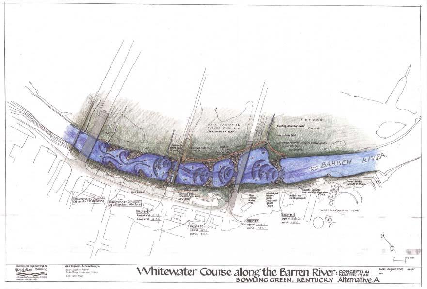
14 economies due to these visitors. Economic impact studies show that whitewater parks in these towns have brought between one and two million dollars a year into the local economy. Bowling Green, which is located in a region that is relatively devoid of whitewater boating, stands to be a tremendous attraction to boaters who would otherwise have to travel great distances for reliable boating and large competitions. Alternatives Considered Alternative A Based on the constraints identified above it can be concluded that the park should seamlessly mesh with the River Walk improvements while providing an easy access recreational amenity to all levels of users from those who wish to simply watch from the shore to those who are seeking top level whitewater competition. The whitewater plan should provide top level boating for expert users while maintaining navigability for all levels of users and providing recreational and instruction paddling opportunities throughout its length. Improvements should be low maintenance and should not affect the City s utility operations or create a flood risk. Furthermore, the facility should function to tie the downtown together with the river as well as create a recreational tourist attraction. The proposed plan features four drop structures that would distribute the head of the existing Waterworks Dam. Each of the drop structures would drop between 1.5 and 2 feet and would create a surfable hydraulic at its base. These structures would operate at a variety of flows, allowing for freestyle kayaking throughout the year even during the lower flow summer months. The drops structures would also control the depth and character of flow and to divert the faster flows away from the bridge abutments that line the river throughout this reach. Additionally, four offset single rock deflectors have been added at the bottom of the reach. These deflectors would create eddy features, to deflect the flow, and, at higher flows, to create series of waves. This area is ideal for beginner instruction and for recreational kayaking. 15
15 Alternative B The second alternative is similar to the first but features six separate drop structures. Drop number four is, again, a split structure. The advantage of this plan is that it features our signature drop structure. This structure is our most popular and has been favored at other sites. This park has many advantages including: Pool and drop whitewater that provides dynamic surfing while also allowing for easy recovery. A large variety of surf waves that can be tailored to specific flow rates providing ideal playspots over a larger spectrum of flows. The ability to create varying difficulty at drops allowing developing boaters to step up through the varying features. In addition to the whitewater, both alternatives mesh with the current development master plan on the parks banks. The park features trail connections to several parts of the existing and planned park. The primary river trail parallels the river along the North bank. This trail extends throughout the reach of the park. Access from this trail is available to all of the drop structures, to the pedestrian bridge/mitch McConnel Park and to the proposed River Walk improvements area. The upper structure would be hydraulically planned to provide a low and high flow chute that channels the water to create a hydraulic while, at the same time, maintaining current low and high water head levels for the City s utilities. No pedestrian access would be provided to this area from the park area. Preferred Alternative The preferred alternative is similar to the first alternative. It consists of four drop structures and two offset connected double deflectors that create six pools. These structures would be constructed in a similar fashion to those in the first alternative. The structures would be composed primarily of large to medium sized grouted rock. The center of the structure would 16
16 be lined with smooth grout. This grouted area is planned to be submerged even during low flow events. From the center of these low flow channels stepped wings (with no exposed grout) would extend to the banks. The stepped wings would be anchored into existing bedrock at the riverbank. As stated above, the drop structures would distribute the head of the BGMU dam. Each drop structure would drop feet to create a surfable hydraulic at the drop base. The structures would operate at a variety of flows, allowing freestyle kayaking throughout the year, including summer and fall months when streamflow levels are low. The drop structures would also control the depth and character of flow and would divert faster flows away from bridge abutments located within the project corridor. Drop number one, the easternmost drop structure, would utilize the remnants of the breached BGMU dam and would include a boat landing on the north bank of the river. Drop number four, the westernmost drop structure, would be connected to the existing pedestrian bridge. This drop structure would differ from the others in that a rock island would be constructed in the channel center; a smooth grouted high flow area would connect the island to the southern stepped wing, and a smooth grouted low flow area would connect the island to the northern stepped wing. A portage trail would begin at the boat landing on the north side of Drop number one and would proceed west along the riverbank to the proposed boat landing at the foot of the pedestrian bridge. A stepped access trail on the south riverbank would provide access to the southern stepped wing of Drop number two. Structures five and six are offset connected double deflectors. As in the first alternative, the deflectors would also be constructed of grouted rock. The deflectors would create eddy features and pools, to deflect flow, and at high streamflow levels, to create series of waves. Unlike the first alternative, however, these deflectors would be connected and slightly elevated. The primary difference between the Preferred Alternative and the first alternative is the elevations of each drop. A detailed conceptual plan has been included in Appendix 1. 17
17 Appendix 1 Barren River Whitewater Park Conceptual Plans 18
18 19

19 20

20 21
21 Table of Contents Abstract...3 Introduction...3 Site Profile: Bowling Green Municipal Utilities Waterworks Dam Site...4 Flow Characteristics...6 Project Planning...9 Whitewater Park User Groups...10 The City of Bowling Green, Kentucky...10 Local Whitewater Club...11 Rafter...11 Recreational Boater...12 Top-Level Boater...13 Spectators...14 Economic Impact...14 Alternatives Considered...15 Alternative A...15 Alternative B...16 Preferred Alternative...16 APPENDIX 1 Barren River Whitewater Park Conceptual Plans
Conceptual Design Report for the Fabri Dam Modifications Project
 Conceptual Design Report for the Fabri Dam Modifications Project Flint, Michigan Prepared For: City of Flint P.O. Box 99 Flint, MI 48501-0099 Flint River Watershed Coalition 432 N. Saginaw St. Suite 1001
Conceptual Design Report for the Hamilton Dam Modifications Project. Flint, Michigan. Prepared For: City of Flint P.O. Box 99 Flint, MI
 Conceptual Design Report for the Hamilton Dam Modifications Project Flint, Michigan Prepared For: City of Flint P.O. Box 99 Flint, MI 48501-0099 Flint River Watershed Coalition 432 N. Saginaw St. Suite
Appendix G Whitewater Recreation Flow Study Plan
 Appendix G Whitewater Recreation Flow Study Plan Study Plan Whitewater Recreation Flow Study Grandfather Falls Hydroelectric Project FERC Project No. 1966 March 2013 An Integrys Energy Group Company Section
JAP Additional Information Sheet
 JAP Additional Information Sheet Block 15: Purpose and Need The USACE purpose of the project is to provide a safe and reliable whitewater park for the recreational public in a city park, which will provide
Focus. Cumberland Whitewater Park. Cumberland Whitewater Park. Read 20 point Comic Sans MS from rear of room. A free flowing natural artificial course
 Cumberland Whitewater Park Cumberland Whitewater Park Focus Read 20 point Comic Sans MS from rear of room 1 Cumberland Whitewater Park by Robert B. Kauffman, Ph.D. Proposed site A free flowing natural
Initial Study Report Whitewater Boating
 Initial Study Report Whitewater Boating Prospect No. 3 Hydroelectric Project FERC Project No. P-2337 PacifiCorp May 2015 South Fork of the Rogue River, 2007 Reproduced with permission from Peter Gandesbery,
Of the following, which best describes you?
 Summary of Downtown Des Moines Dam Debate April 26 th, 2016 The following are the responses we heard from participants in the Dam Debate cohosted by the Register and the Des Moines Area Metropolitan Planning
STATUS REPORT FOR THE SUBMERGED REEF BALL TM ARTIFICIAL REEF SUBMERGED BREAKWATER BEACH STABILIZATION PROJECT FOR THE GRAND CAYMAN MARRIOTT HOTEL
 August 23 STATUS REPORT FOR THE SUBMERGED REEF BALL TM ARTIFICIAL REEF SUBMERGED BREAKWATER BEACH STABILIZATION PROJECT FOR THE GRAND CAYMAN MARRIOTT HOTEL performed by Lee E. Harris, Ph.D., P.E. Consulting
CHAPTER X: PORTAGES AROUND DAMS
 CHAPTER X: PORTAGES AROUND DAMS A. General Description Portages are land routes used by paddlers to transport their boats to and from a launch area or between access sites. Often located along water bodies
DESCRIPTION OF THE CHELAN RIVER
 DESCRIPTION OF THE CHELAN RIVER The following information contains excerpts from the Whitewater Boating Feasibility Study conducted on the Chelan River in July, 2000. The Chelan River begins below the
MnPASS System Today and the Future
 MnPASS System Today and the Future April 2010 By Nick Thompson Minnesota Department of Transportation Topics Minnesota s Current and Future MnPASS High Occupancy Toll Systems Overview of the MnPASS System
Comal River. Improvements Project Existing Conditions Assessment
 Comal River Improvements Project Existing Conditions Assessment Prince Solms Park Hinman Island Park Tube Chute Park Mill St. Property Stinky Falls Weir Focus Areas Focus Areas Last Public Exit Assessment
IP SH R SO N O Royal Gorge Whitewater Festival June 26-27, 2015 SP
 SPONSORSHIP Royal Gorge Whitewater Festival June 26-27, 2015 The Whitewater Kayak Recreation Park (WKRP), Cañon City Recreation and Park District, the Fremont Community Foundation, and Fremont Adventure
The Economic Importance of Recreational River Use to the City of Calgary
 The Economic Importance of Recreational River Use to the City of Calgary Prepared by: Calgary River Users Alliance May 20, 2016 The Economic Importance of Recreational River Use to the City of Calgary
APPENDIX C BLUEWAYS ASSESSMENT
 APPENDIX C Blueways Assessment Poor Fork of Cumberland River Section above Kingdom Come State Park and Cumberland, KY By Steve Spencer, Ed.D. Western Kentucky University The author is an American Canoe
TAPOCO PROJECT FERC NO CHEOAH RIVER RECREATION STUDY FINAL REPORT
 TAPOCO PROJECT FERC NO. 2169 Prepared by Kleinschmidt Associates January 2002 TABLE OF CONTENTS EXECUTIVE SUMMARY... 1 1.0 INTRODUCTION... 5 2.0 RIVER CHARACTERIZATION AND CONTROLLED FLOW ASSESSMENT...
Colorado Avenue Dam Proposed Paddle Trail Improvements Preliminary Design Report Deschutes River, Bend, Oregon
 Colorado Avenue Dam Proposed Paddle Trail Improvements Preliminary Design Report Deschutes River, Bend, Oregon Prepared For: Bend Metro Park and Recreation District 799 SW Colombia Street Bend, Oregon
Annex E Bridge Pier Protection Plan
 Annex E Bridge Pier Protection Plan Table E1 Bridge Types and Locations Table E2 Flow Conditions For River Sections Figure E1 Bridge Abutment Protection Figure E2 Bridge Pier Protection Figure E3 Central
CITY OF NEWPORT BEACH HARBOR COMMISSION STAFF REPORT
 CITY OF NEWPORT BEACH HARBOR COMMISSION STAFF REPORT Agenda Item No. 2 TO: FROM: SUBJECT: HARBOR COMMISSION Harbor Resources Division (City Manager's Office) Chris Miller, Harbor Resources Supervisor,
Vision: Traditional hamlet with an attractive business/pedestrian friendly main street connected to adjacent walkable neighborhoods
 N D. Focus Area II Vision: Traditional hamlet with an attractive business/pedestrian friendly main street connected to adjacent walkable neighborhoods Transit Road Focus Area II is located in the Hamlet
Plan B Dam Breach Assessment
 Plan B Dam Breach Assessment Introduction In support of the Local Sponsor permit applications to the states of Minnesota and North Dakota, a dam breach analysis for the Plan B alignment of the Fargo-Moorhead
Main Building and raft building viewed from the south side of the Oklahoma River. The white water Main Building anchors the development.
 Client: OKCMAPS Office Completion: April 2016 Scope: Main Building: 16,326 SF Raft Storage Building: 2,041 SF Kayak Storage Building: 1,348 SF Rotary Point Pavilion: 1,387 SF Cost: $45.2 M Awards: RIVERSPORT
River Dynamics - Rafting FOCUS. Read 10 point text from rear of the room. Bottom
 Dynamics - Rafting FOCUS Read 10 point text from rear of the room. Bottom 1 This section focuses on rivers; how they flow and on some basic maneuvers which you can execute on the river. Dynamics Rafting:
River. Dynamics Canoeing: This section focuses on rivers; how they flow and on some basic maneuvers which you can execute on the river.
 This section focuses on rivers; how they flow and on some basic maneuvers which you can execute on the river. Dynamics Canoeing: By Robert B. Kauffman, Ph.D. 1 Topics - Laminar and shore to center flows
City of Wilsonville 5 th Street to Kinsman Road Extension Project
 City of Wilsonville 5 th Street to Kinsman Road Walking Tour & Neighborhood Workshop Summary Report Public Outreach Overview On July 18 th, 2017, the City of Wilsonville hosted a neighborhood walking tour
Route 79/Davol Street Corridor Study
 Route 79/Davol Street Corridor Study Fall River, MA Public Information Meeting #2 November 21, 2013 Fall River Heritage State Park Fall River, MA Agenda Welcome and Introductions Overview of Study Process
Proposed. City of Grand Junction Complete Streets Policy. Exhibit 10
 Proposed City of Grand Junction Complete Streets Policy Exhibit 10 1 City of Grand Junction Complete Streets Policy Vision: The Complete Streets Vision is to develop a safe, efficient, and reliable travel
Tuckasegee Paddling Flow Study Results FERC # s 2686, 2698, /20/02
 Tuckasegee River Paddling Recreational Instream Flow Study East Fork, West Fork, and Dillsboro Hydroelectric Projects FERC # s 2698, 2686, 2602 Dillsboro and Whittier Sections - July 2-3, 2001 West Fork
USING A LABYRINTH WEIR TO INCREASE HYDRAULIC CAPACITY. Dustin Mortensen, P.E. 1 Jake Eckersley, P.E. 1
 USING A LABYRINTH WEIR TO INCREASE HYDRAULIC CAPACITY Dustin Mortensen, P.E. 1 Jake Eckersley, P.E. 1 Plum Creek Floodwater Retarding Structure No. 6 is located in an area of Kyle, Texas, that is currently
APPENDIX C VEGETATED EMERGENCY SPILLWAY. VERSION 1.0 March 1, 2011
 APPENDIX C VEGETATED EMERGENCY SPILLWAY VERSION 1.0 March 1, 2011 [NOTE: Could use a better photo more clearly showing the emergency spillway in the context of the dam.] SECTION C-1: DESCRIPTION OF PRACTICE
County of Orange Resources and Development Management Department Harbors, Beaches and Parks. Strategic Plan. HBP Strategic Plan Workshop 1.
 County of Orange Resources and Development Management Department Harbors, Beaches and Parks Strategic Plan HBP Strategic Plan Workshop 1 v18 PRESENTATION OUTLINE Harbors, Beaches & Parks (HBP) History
4 Goals, Objectives & Actions
 Chapter4 4 This chapter presents goals, objectives, and recommended actions to support the vision of making Overland Park a safer and easier place to ride a bicycle. 35 4.1 Recommendations Structure The
Little Spokane River Stream Gage Report: Deadman Creek, Dragoon Creek, and the West Branch of the Little Spokane River
 Little Spokane River Stream Gage Report: Deadman Creek, Dragoon Creek, and the West Branch of the Little Spokane River June 2010 Spokane County Conservation District N. 210 Havana St. Spokane, WA 99202
PLEASE NOTE: The Black Canyon is a Class 5 Boating Opportunity. Experts Only
 PLEASE NOTE: The Black Canyon is a Class 5 Boating Opportunity Experts Only The Black Canyon is rated Class 5 1 whitewater, appropriate for expert boaters only. Class 5 whitewater is described as extremely
McLean Main Street Public Forum Follow-up
 McLean Main Street Public Forum Follow-up Sponsored & Hosted by John W. Foust, Dranesville District Supervisor McLean Planning Committee Fairfax County Office of Community Revitalization and Reinvestment
5 Circulation & Parking
 5 Circulation & Parking Downtown Parking & Circulation Strategy. Downtown Wayne has a somewhat disconnected system of local public streets to connect downtown with the residential neighborhoods, and primary
IP SH R SO N O Royal Gorge Whitewater Festival June 23-24, 2017 SP
 SPONSORSHIP Royal Gorge Whitewater Festival June 23-24, 2017 The Whitewater Kayak Recreation Park (WKRP), Cañon City Recreation and Park District, the Fremont Community Foundation, and Fremont Adventure
Paddlesports Safety Facilitator - SUP
 SUP Module Overview: We expect Paddlesports Safety Facilitators (PSF) for the SUP Module to be able to effectively maneuver their board, and demonstrate competent rescue techniques. This certification
MAG Town of Cave Creek Bike Study Task 6 Executive Summary and Regional Significance Report
 Page 1 MAG Town of Cave Creek Bike Study Task 6 Executive Summary and Regional Significance Report August 1, 2012 MAG Project #481 Page 2 Task 6 Executive Summary and Regional Significance Report Introduction
STRUCTURE S-65 PURPOSE SPILLWAY OPERATION
 STRUCTURE S-65 This structure is a reinforced concrete, gated spillway with discharge controlled by three cable operated, vertical lift gates, and a reinforced concrete lock structure with two pairs of
Clackamas River Hydroelectric Project Flows and whitewater recreation: Updated information about Three Lynx and Bob s Hole boating
 Clackamas River Hydroelectric Project Flows and whitewater recreation: Updated information about Three Lynx and Bob s Hole boating Prepared for Portland General Electric 121 SW Salmon Street Portland,
FISH PASSAGE ALTERNATIVES ANALYSIS ON PENNYPACK CREEK AT VERREE ROAD DAM AND ROOSEVELT BOULEVARD DAM PHILADELPHIA, PENNSYLVANIA
 FISH PASSAGE ALTERNATIVES ANALYSIS ON PENNYPACK CREEK AT VERREE ROAD DAM AND ROOSEVELT BOULEVARD DAM PHILADELPHIA, PENNSYLVANIA Prepared for: One Parkway, 10 th Floor 1515 Arch Street Philadelphia, PA
 Time of Change We Are Growing We Are An Attractive Place To Live We Are Age Diverse + Living Longer 50000 40000 30000 20000 10000 0 2010 Census Job Density Housing Sheds Transit Sheds The Project FUNDING
TRANSPORTATION & MOBILITY
 TRANSPORTATION & MOBILITY ROADWAY SYSTEM There are approximately 40 miles of roadways in Manitou Springs. For planning purposes, roadways are typically assigned a functional classification which defines
Analysis of 2015 Trail Usage Patterns along the Great Allegheny Passage
 Analysis of 2015 Trail Usage Patterns along the Great Allegheny Passage Prepared for the Allegheny Trail Alliance, August 2016 By Dr. Andrew R. Herr Associate Professor of Economics Saint Vincent College
PEDESTRIAN ACTION PLAN
 ATTACHMENT 2 CITY OF SANTA MONICA PEDESTRIAN ACTION PLAN CITY OF SANTA MONICA PEDESTRIAN ACTION PLAN This page intentionally left blank EXECUTIVE SUMMARY CHAPTER 1 EXECUTIVE SUMMARY Setting the Stage
Public Works and Infrastructure Committee. General Manager, Transportation Services
 STAFF REPORT ACTION REQUIRED Establishment of One Toronto Marathon Date: January 21, 2010 To: From: Wards: Reference Number: Public Works and Infrastructure Committee General Manager, Transportation Services
COMPARISON OF FIXED & VARIABLE RATES (25 YEARS) CHARTERED BANK ADMINISTERED INTEREST RATES - PRIME BUSINESS*
 CHARTERED BANK ADMINISTERED INTEREST RATES - PRIME BUSINESS*") COMPARISON OF FIXED & VARIABLE RATES (25 YEARS) Fixed Rates Variable Rates FIXED RATES OF THE PAST 25 YEARS AVERAGE RESIDENTIAL MORTGAGE LENDING RATE - 5 YEAR* (Per cent) Year Jan Feb Mar Apr May Jun Jul
COMPARISON OF FIXED & VARIABLE RATES (25 YEARS) Fixed Rates Variable Rates FIXED RATES OF THE PAST 25 YEARS AVERAGE RESIDENTIAL MORTGAGE LENDING RATE - 5 YEAR* (Per cent) Year Jan Feb Mar Apr May Jun Jul
Follow this and additional works at:
 University of Massachusetts Amherst ScholarWorks@UMass Amherst International Conference on Engineering and Ecohydrology for Fish Passage International Conference on Engineering and Ecohydrology for Fish
Micro Hydropower and Fish.
 Micro Hydropower and Fish. Garry O Neill. Senior Fisheries Officer. Inland Fisheries Branch. 1. Value of Fisheries. 2. Life cycle of the Salmon. 3. Potential impacts of Hydro s on Fish. 4. Fisheries Legislation.
Surfing Tourism Destination Feasibility Study, Kincardine, Ontario
 Surfing Tourism Destination Feasibility Study, Kincardine, Ontario Prepared for: Regional Tourism Organization 7 and the February 24, 2014 EXECUTIVE SUMMARY With support from the Regional Tourism Organization
Bicycle Friendly Niagara Falls
 Bicycle Friendly Niagara Falls STAKEHOLDER COMMITTEE MEETING 2 SUPPORTED BY THE OATH COMMUNITY FUND AT THE COMMUNITY FOUNDATION FOR GREATER BUFFALO Develop a Bicycle Master Plan to document the city s
Lower Coquitlam River Project Water Use Plan. Temperature Monitoring Lower Coquitlam River Project Year 2 Report
 Lower Coquitlam River Project Water Use Plan Temperature Monitoring Lower Coquitlam River Project Year 2 Report COQMON#6 Temperature Monitoring Study Lower Coquitlam River Study Period: Year 2-2007 Report
STRATEGIC PLANNING FOR DEVELOPMENT OF THE OREGON SHORT LINE TERMINUS HISTORIC DISTRICT
 STRATEGIC PLANNING FOR DEVELOPMENT OF THE OREGON SHORT LINE TERMINUS HISTORIC DISTRICT & AN EXECUTIVE SUMMARY OF THE HEART OF WEST YELLOWSTONE CONCEPTUAL PLANNING REPORT November 2004 PREPARED BY The Portico
Chadbourne Dam Repair and Fish Barrier
 Chadbourne Dam Repair and Fish Barrier Final Report for the Western Native Trout Initiative Prepared by: Carol Endicott Yellowstone Cutthroat Trout Conservation Biologist Montana Fish, Wildlife & Parks
MEMORANDUM. Existing Operations. City of Clearwater. Michael Herrman. Date: January 26, Seminole Boat Launch Overview. M&N Job No.
 1509 W. Swann Avenue, Suite 225 Tampa, FL 33606 (813) 258-8818 Fax (813) 258-8525 www.moffattnichol.com MEMORANDUM To: From: City of Clearwater Michael Herrman Date: Subject: Seminole Boat Launch Overview
Executive Summary Route 30 Corridor Master Plan
 Route Corridor Master Plan Project Overview The Route Corridor Master Plan is a coordinated multimodal transportation and land use plan for the entire stretch of Route through East Whiteland Township,
OPPORTUNITIES & CONSTRAINTS
 OPPORTUNITIES & CONSTRAINTS Grand Rapids Restoration August 2012 We have inherited the past; we can create the future Unknown TABLE OF CONTENTS ES-1 ES-1...... BACKGROUND CONCEPTUAL PLAN ES-2... OPPORTUNITIES
East Burke Transportation, Safety and Capacity Improvements
 East Burke Transportation, Safety and Capacity Improvements The purpose of this project is to increase mobility and improve safety for pedestrians, cyclists, and motor vehicles along VT Route 114 in the
Wisconsin 511 Traveler Information Annual Usage Summary January 3, Wisconsin 511 Phone Usage ( )
") Wisconsin 511 Traveler Information 211 Annual Usage Summary January 3, 212 Overall to-date Summary 36 months of operation 1,16,63 total calls the 1 Million mark was passed on December 3, 212 3,627,527
Wisconsin 511 Traveler Information 211 Annual Usage Summary January 3, 212 Overall to-date Summary 36 months of operation 1,16,63 total calls the 1 Million mark was passed on December 3, 212 3,627,527
Active Transportation Rail to River Corridor. Community Meeting - Segment A
 Active Transportation Rail to River Corridor Community Meeting - Segment A June 29, 2017 Tonight s Agenda > Open House (30 min) > Welcome / Project Overview > Presentation of 30% Design Refinements > Next
Guam Future Hotel Supply Requirements. Presented By: Damien Little, Horwath HTL
 Guam Future Hotel Supply Requirements Presented By: Damien Little, Horwath HTL Outline Current Strengths/Weaknesses of Guam Seasonal Tourism Performance Tourism Growth Projections Future Hotel Supply Requirements
Please find attached our bid submission for the 2015 ACA Open Canoe Slalom Nationals & North American Championships for consideration.
 Ottawa, January 14, 2015 ACA Open Canoe Slalom Committee Active Chair: Michael Cook Dear Mike, Please find attached our bid submission for the 2015 ACA Open Canoe Slalom Nationals & North American Championships
Exhibit 1 PLANNING COMMISSION AGENDA ITEM
 Exhibit 1 PLANNING COMMISSION AGENDA ITEM Project Name: Grand Junction Circulation Plan Grand Junction Complete Streets Policy Applicant: City of Grand Junction Representative: David Thornton Address:
ST. LOUIS SECTION PROJECT OF THE YEAR AWARD
 ST. LOUIS SECTION PROJECT OF THE YEAR AWARD Originality and Innovation The St. Louis Harbor Project is located in the Upper Mississippi River between the entrance to the Chain of Rocks Canal at River
10-1. offers two different segments that provide excellent boating opportunities to both beginner and intermediate skill levels.
 10 Aquatic Trail The Carson River through Carson City is a beautiful resource that provides a source of water, wildlife habitat, and recreational opportunities such as fishing, swimming and boating. The
Paddlesports Safety Facilitator
 General Knowledge Module Overview: Fundamentally, we expect that Paddlesports Safety Facilitators (PSF) should have the ability to manage groups, have background knowledge of paddling safety and environmental
CROSS-SHORE SEDIMENT PROCESSES
 The University of the West Indies Organization of American States PROFESSIONAL DEVELOPMENT PROGRAMME: COASTAL INFRASTRUCTURE DESIGN, CONSTRUCTION AND MAINTENANCE A COURSE IN COASTAL DEFENSE SYSTEMS I CHAPTER
Low Gradient Velocity Control Short Term Steep Gradient Channel Lining Medium-Long Term Outlet Control Soil Treatment Permanent [1]
![Low Gradient Velocity Control Short Term Steep Gradient Channel Lining Medium-Long Term Outlet Control Soil Treatment Permanent [1]](/thumbs/80/80811988.jpg "Low Gradient Velocity Control Short Term Steep Gradient Channel Lining Medium-Long Term Outlet Control Soil Treatment Permanent [1]") Check Dams DRAINAGE CONTROL TECHNIQUE Low Gradient Velocity Control Short Term Steep Gradient Channel Lining Medium-Long Term Outlet Control Soil Treatment Permanent [1] [1] Though not generally considered
Check Dams DRAINAGE CONTROL TECHNIQUE Low Gradient Velocity Control Short Term Steep Gradient Channel Lining Medium-Long Term Outlet Control Soil Treatment Permanent [1] [1] Though not generally considered
Response of a Newly Created Marsh-Wetland Affected by Tidal Forcing, Upland Discharge, and Groundwater Interaction
 Response of a Newly Created Marsh-Wetland Affected by Tidal Forcing, Upland Discharge, and Groundwater Interaction Mouth of Columbia River, Cape Disappointment State Park, Washington 12 Hans R. Moritz
Chapter 5 Future Transportation
 Chapter 5 Future Transportation The Future Land Use Plan identifies the desired land use designations. The land uses desired for Crozet depend, in large part, on the success of the transportation system,
Understanding the Impacts of Culvert Performance on Stream Health
 Understanding the Impacts of Culvert Performance on Stream Health Kristin Thomas Aquatic Ecologist Michigan Trout Unlimited Transportation and the Environment Conference 12/5/2018 Importance of adequately
JEFFERSON COUNTY BIKE PLAN 2010: EMPHASIS SUMMARY
 JEFFERSON COUNTY BIKE PLAN 2010: EMPHASIS SUMMARY Presented at Jefferson and Walworth County Bicycle Forum Series Summer 2011 By: Steve Grabow, Professor and Community Development Educator UW-Extension,
Swimming and Wading Techniques in Swiftwater Rescue Outline I. Description
 I. Description A. This component of the Curriculum is designed to give the students effective strategies for swimming in moving water and whitewater. II. Objectives A. Upon completion of this component
RLRC COMMUNITIES EAST GRAND FORKS AREA CHARACTER THE RED LAKE RIVER & THE RED RIVER OF THE NORTH CONFLUENCE EAGLE POINT BOAT LAUNCH DESIGN
 AREA CHARACTER THE RED LAKE RIVER & THE RED RIVER OF THE NORTH CONFLUENCE EAGLE POINT BOAT LAUNCH DESIGN DESIGN DETAILS 135 AREA CHARACTER East Grand Forks a city of 7,501 people is located across the
North Diversion Channel Physical Modeling:
 North Diversion Channel Physical Modeling: Bike Notch Implementation Between Vineyard Arroyo Confluence to Osuna Bridge August 29, 2011 Prepared for Albuquerque Metropolitan Arroyo Flood Control Authority
Via . March 31, Whitewater Boating Flow Study Working Group
 Via Email March 31, 2016 TO: Whitewater Boating Flow Study Working Group SUBJECT: Bear Swamp Project (FERC Project No. 2669) Whitewater Boating Flow Study Survey Forms Dear Stakeholder: Bear Swamp Power
Roanoke River Blueway
 Roanoke River Blueway Roanoke River Currents Conference Friday October 9, 2015 Ferrum College Shane Sawyer, Regional Planner Roanoke Valley - Alleghany Regional Commission Roanoke River Blueway www.roanokeriverblueway.org
MEETING Agenda. Introductions. Project Overview. Key Study Components. Alternative Station Concepts. Preferred Station Concept. Next Steps.
 City GARLAND Council ROADVISION Briefing STUDY VISION STUDY Dallas, TX April 8, 2010 1 1 MEETING Agenda Introductions Project Overview Key Study Components Alternative Station Concepts Preferred Station
Exit 13/Golden Triangle Study FREQUENTLY ASKED QUESTIONS
 FREQUENTLY ASKED QUESTIONS How will you improve traffic in the Golden Triangle? One main goal of this study is to examine the current traffic patterns of the area and propose ways to improve the traffic.
DALE HOLLOW LAKE TROOPER ISLAND IMPROVEMENT PROJECT Proposal for Reservoir Fisheries Habitat Partnership (RFHP)
") DALE HOLLOW LAKE TROOPER ISLAND IMPROVEMENT PROJECT Proposal for Reservoir Fisheries Habitat Partnership (RFHP) A. Applicant Information: US Army Corps of Engineers, Dale Hollow Lake POC: Gregg Nivens
DALE HOLLOW LAKE TROOPER ISLAND IMPROVEMENT PROJECT Proposal for Reservoir Fisheries Habitat Partnership (RFHP) A. Applicant Information: US Army Corps of Engineers, Dale Hollow Lake POC: Gregg Nivens
PROJECT OVERVIEW PROJECT AREA. FAHCE Fish Habitat Restoration Plan EIR
 PROJECT OVERVIEW PROJECT AREA FISH AND AQUATIC HABITAT COLLABORATIVE EFFORT (FAHCE) Fish Habitat Restoration Plan Project Area PROJECT OVERVIEW DOCUMENTS A Settlement Agreement Regarding Water Rights of
Wasson Way Bike Path Tourism Impact. Biking tourism is best defined as recreational visits, either overnight or day visits away
 Basheer Alshammari Sammy Dabdoub Dr. Colleen McTague Geog 7060 & 6069 Term Paper April 22, 2014 ------------------------------------------------------------------------------------------------------------
Thesis Presentation. Moorhead City Walk: A Master Plan to Reimage Moorhead, Minnesota s Urban Core. Brad Garcia Advisors: Jason Kost & Dominic Fischer
 Thesis Presentation Moorhead City Walk: A Master Plan to Reimage Moorhead, Minnesota s Urban Core Brad Garcia Advisors: Jason Kost & Dominic Fischer MOORHEAD, MN Red River Center Ave 8 TH St N FARGO, ND
Canoe/Kayak Launch Sites and Accessibility
 Canoe/Kayak Launch Sites and Accessibility Doug Alderson, Paddling Trails Coordinator Division of Recreation and Parks Office of Greenways and Trails Each potential access site on a river, lake or ocean
(Revised February,2005) CULVERTS, BRIDGES, AND FORDS
 CULVERTS, BRIDGES, AND FORDS") GUIDE TO STREAM CROSSINGS (Revised February,2005) CULVERTS, BRIDGES, AND FORDS Culverts, bridges, and fords are all methods used to cross-streams. Culverts are the most common stream crossing structure.
GUIDE TO STREAM CROSSINGS (Revised February,2005) CULVERTS, BRIDGES, AND FORDS Culverts, bridges, and fords are all methods used to cross-streams. Culverts are the most common stream crossing structure.
Manufacturers Continue Capacity Expansion as Technology Orders Grow
 Contact: Penny Brown, AMT, 703-827-5275 pbrown@amtonline.org For Release: October 8th, 2018 Manufacturers Continue Capacity Expansion as Technology Orders Grow Manufacturing technology orders posted an
Coastal and marine recreation in New England is ingrained in the region s economic and
 RECREATION Coastal and marine recreation in New England is ingrained in the region s economic and social fabric. Recreation on the ocean and coast includes many of New Englanders most time-honored and
TO: Board Members Vancouver Park Board FROM: General Manager Parks and Recreation SUBJECT: Seaside Greenway Improvements
 Date: October 1, 2013 TO: Board Members Vancouver Park Board FROM: General Manager Parks and Recreation SUBJECT: Seaside Greenway Improvements RECOMMENDATION A. THAT the Board approve the new bike paths
Bikeway action plan. Bicycle Friendly Community Workshop March 5, 2007 Rochester, MN
 Bikeway action plan Summary The was held on March 5, 2007 at the Rochester Mayo Civic Center. The workshop was hosted by Rochester-Olmsted County Planning Department in collaboration with the League of
Shoreline Studies Program, Department of Physical Sciences, VIMS
 Living Shoreline Training Class 2017 1 Demonstration sites discussed in this talk. 2 A shoreline management plan for the entire creek made conceptual shoreline management recommendations along every stretch
TESTIMONY OF THOMAS O KEEFE, PhD PACIFIC NORTHWEST STEWARDSHIP DIRECTOR ON BEHALF OF AMERICAN WHITEWATER
 TESTIMONY OF THOMAS O KEEFE, PhD PACIFIC NORTHWEST STEWARDSHIP DIRECTOR ON BEHALF OF AMERICAN WHITEWATER OREGON STATE HOUSE House Committee on Transportation Policy Representative Caddy McKeown, Chair
Coquitlam/Buntzen Project Water Use Plan
 Coquitlam/Buntzen Project Water Use Plan Temperature Monitoring Lower Coquitlam River Project Year 3 Report Reference: COQMON#6 Study Period: March 2008 April 2009 Report Date: April 2009 Trow Associates
A good example of trees left in place that do not detract from the strategy of the golf.
 Here, natural trees left in place are beginning to hide the green area and a good portion of the pond. The hole and water hazard would be more interesting to the golfer if the water were more visible from
COMMENT CARD SUMMARY
 NORTH PARK MID-CITY REGIONAL BIKE CORRIDORS PROJECT SAN DIEGO ASSOCIATION OF GOVERNMENTS COMMUNITY ADVISORY GROUP MEETING 1 January 30, 2013 6:00 p.m. 8:30 p.m. City Heights Wellness Center 4440 Wightman
Iowa Department of Natural Resources Iowa Water Trails Grant Program
 Iowa Department of Natural Resources Iowa Water Trails Grant Program Submitted by the City of Story City in conjunction with the Skunk River Paddlers and the Story County Conservation Board Tuesday, January
The approach of CanoeKayak BC Whitewater (CKBC-WW) to River Access issues is driven by the organizational Mission Statement:
 to River Access issues is driven by the organizational Mission Statement:") CanoeKayak BC - Whitewater DRAFT RIVER ACCESS POLICY For Comment The approach of CanoeKayak BC Whitewater (CKBC-WW) to River Access issues is driven by the organizational Mission Statement: Provide structure
CanoeKayak BC - Whitewater DRAFT RIVER ACCESS POLICY For Comment The approach of CanoeKayak BC Whitewater (CKBC-WW) to River Access issues is driven by the organizational Mission Statement: Provide structure
CITY COUNCIL AGENDA REPORT
 CITY COUNCIL AGENDA REPORT Subject: GROSVENOR POOL REPORT Recommendation(s) 1. That the Grosvenor Outdoor Pool Report Part 2, 2015, provided as Attachment 1 to the Grosvenor Pool Report agenda report dated
Tonight is for you. Learn everything you can. Share all your ideas.
 Strathcona Neighbourhood Renewal Draft Concept Design Tonight is for you. Learn everything you can. Share all your ideas. What is Neighbourhood Renewal? Creating a design with you for your neighbourhood.
Figure 4, Photo mosaic taken on February 14 about an hour before sunset near low tide.
 The Impact on Great South Bay of the Breach at Old Inlet Charles N. Flagg and Roger Flood School of Marine and Atmospheric Sciences, Stony Brook University Since the last report was issued on January 31