Deadman s Island Appreciation for past, present and future. Project Manager- Heather Reed Ecological Consulting Services Inc.
|
|
|
- Aron Norton
- 6 years ago
- Views:
Transcription

1 Deadman s Island Appreciation for past, present and future Project Manager- Heather Reed Ecological Consulting Services Inc.
2 Deadman s Island


3 Rare Gem


4


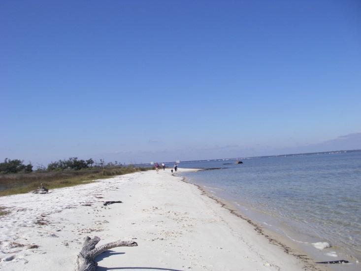
5 18 th Century Used by the Spanish and British throughout the 18 th century as a careening ground George Gauld west end of Island was used as a wharf for careening but became in bad shape and had to be moved.

6 Sold from Spanish 1818

7 1882

.")
8 19 th Century 19th Century used to quarantine ships during yellow fever epidemics 1888 work started on construction of of a marine slip on the island capable of lifting 2000 lb Marine Rail Slip (brick boat slips which are slowly being uncovered to this day) Quarantine station was built

9 1879


10 Gulf Marine Way
11 1919 Fertilizer Plant
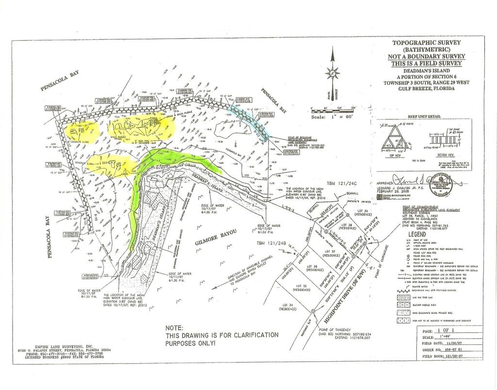
12 20 th Century **Hurricane 1906 obliterated the effort 1906 Remains were used to build a glue factory then a fish fertilizer plant Partnership of Coe and Gilmore bought the Island from the Lewis Bear estate and remained private until City purchased part of it and then was later donated the rest in 1978

13 Shipwreck Found at Deadman s Island
14 Erosion problems and proposed restoration Bridge construction, dredging, sea walls and revetment are making the sediment budget out of balance Concerned residents 2005 Hurricane Ivan exposed historic archeaological artifacts. The City did not have the funding to restore the Island. The USACOE began the restoration effort and permit. The City and Coastal Aquatic Managed Areas of FLDEP have partnered to restore Deadman s Island and achieve the 1992 Aquatic Preserve mission to make Deadman s Island an Aquatic Preserve to be protected by the State.

15 2006

16


17 Historical Erosion of Dead Man s Island Dead Man s Island 1946 Dead Man s Island 1968 Dead Man s Island 1976 Note the seawalls in yellow Dead Man s Island 2005 Note the seawalls in yellow


18 Hurricane Dennis Courtesy of the University of West Florida and State Archeologist, Ryan Wheeler Oct 2011 Coffins dated from the 1800 s were unearthed by erosion from Hurricane Dennis. It is unknown what other artifacts have been lost to shifting tides and other storms which cause further erosion.

19
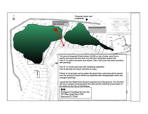


20 Breakwater Shoreline Stabilization Fill/renourishment Design plans


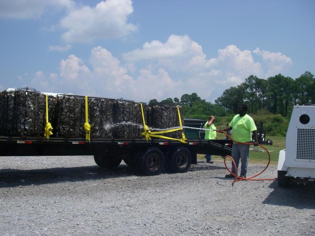
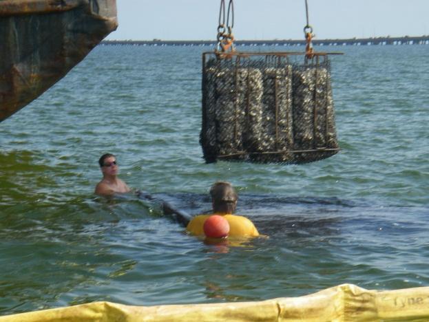
21 Florida Geological Survey


22 Permitting


23 Aerials 01/03/2010 Photos Bob Han and Van Van Tassel


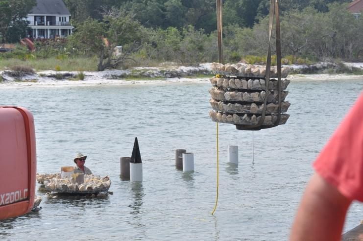
24 Community Involvement Community has shown support for many yearsgrassroots effort Educational outreach and community efforts- Georgestone Technical school and Escambia County, Gulf Breeze High School, Dive Pros dive Shop, US NAVY, Rotary Clubs, FAEP, other professional clubs for planting, placement and monitoring assistance.


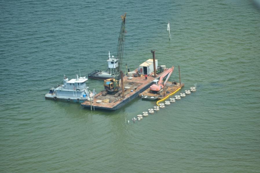
25 Coastal Environments Inc. Coastal Environments Inc. Phase 1 Design Matt Ingram Engineering *

26 2009 Storms


27 August 18, 2009 Claudette Claudette 25 kts


28


29 Oyster


30 New growth within two weeks Photo by Krista Reed


31 November 4-10, 2009 Hurricane Ida December 2, two day surge had winds comparable to IDA and did MORE damage on the west sides (scarps and tree loss) Storm Surge with winds as high as IDA December 2, 2009 During hurricane winds came out of Northeast lifted the structures repeatedly for three or four days

32 Observations Depth limited- 3ft breakwater in 2-6ft water When lowered bags flair out and the oyster shell height drop Exposure to tides- oysters can remain closed for over eight hours but this is at risk- leaving them open to potential stress and disease The oysters growth rate increases on the inside of the unit rather than out side. More circulation, less wave action Unsure of salinity to sustain the reef

33 Phase 2 Design Not Depth limited No Anchoring Ecodiscs by Walter Marine Three substrate compositions for strength includes oyster shell Will not be affected by Tide exposure or salinity changes More effective as a wave attenuator


34 First Ecodisc

35


36


37 Ecosdiscs July and Sept 2011


38 Accretion Monitoring


39
 Mojarras (Diapterus auratus) Mullet (Mugil cephalus) Pufferfish (Spheroidea nephalus) Ladyfish (elops saurus) Flounder (Paralichthys")
40 Fish monitoring/predation Sheepshead (Archosargus probatocephalus) Pinfish (Lagodon rhomboides) Grey/Mangrove snapper (Lutjanus griseus ) Mojarras (Diapterus auratus) Mullet (Mugil cephalus) Pufferfish (Spheroidea nephalus) Ladyfish (elops saurus) Flounder (Paralichthys sp)


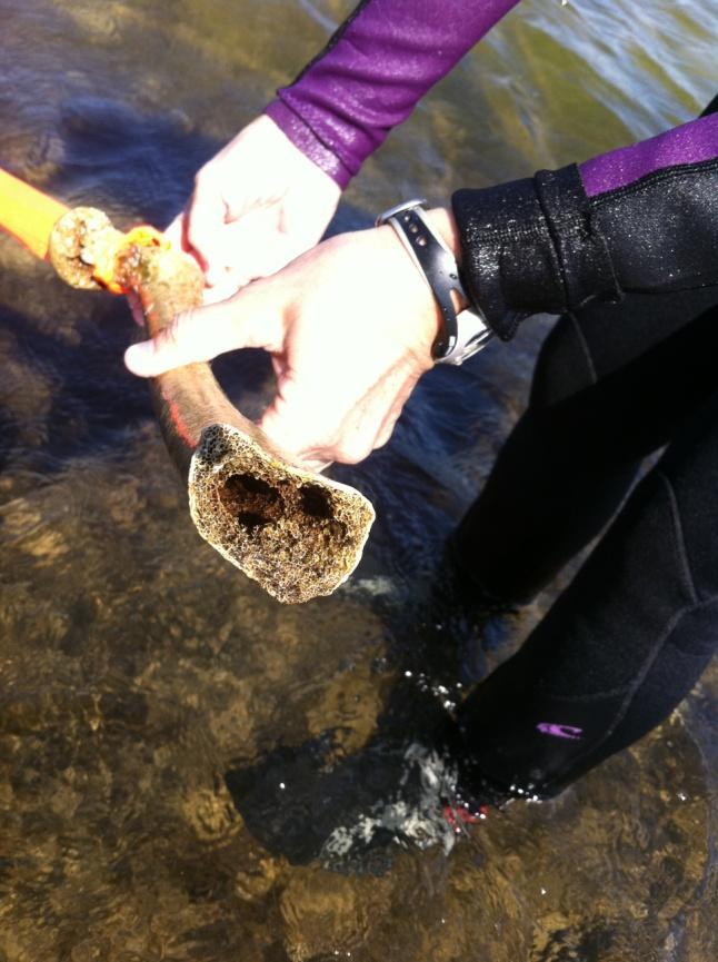
41 Predation Oyster Drills (drill holes) Tulips Herons Some fish Crabs (crush) Flounder Snapper Sheepshead and snapper


42
43 Tide exposed bag at MLW Monitoring Statistics Unit # vs % Cover Oyster AVG % Oys y = x 2 Poly x (AVG + % Oys) R 2 = Unit # vs Avg Oyster Size y = x x R 2 = Avg Oyster size (cm) Poly. (Avg Oyster size (cm)) Bag exposed at MLW vs Accretion Accretion (in) Bag MLW (in) Linear (Bag MLW (in)) y = x R 2 = Unit # vs Accretion Bag exposed at MLW vs % cover oyster Bag exposed at MLW vs Largest Oyster size y = x x R 2 = Accretion (AVG, inch) Poly. (Accretion (AVG, inch)) y = x R 2 = AVG % Oys Linear (AVG % Oys) y = x R 2 = Largest Oyster (cm) Linear (Largest Oyster (cm)) Bag exposed at MLW vs % Barnacle cover AVG % bar 15 Linear (AVG % bar) 10 y = x R 2 = Unit# vs Bag exposed at MLW (in) Bag MLW (in) 10 Poly. (Bag MLW (in)) 5 y = x x R 2 = Bag exposed at MLW vs Avg Oyster size (cm) y = x R 2 = Avg Oyster size (cm) Linear (Avg Oyster size (cm)) Percent Cover Average Size Bag exposure Oyster Drills/crabs Barnacle


44 Ecology Predation Species competition Population growth Invasive species Disease
45 What s next?


46 Underwater Education Snorkel Park Under water Kiosks of Fish/Invertebrate Identification and information Replicas of Historic resources


47 Navigational Aids/Gulf Sturgeon Monitoring


48 Army Corps of Engineers FLDEP Coastal Aquatic Managed Areas NOAA National Fish and Wildlife Foundation Five Star Partners UWF Archeology Dept Escambia County Board of Education Georgestone Technical School Santa Rosa County US Fish and Wildlife Partnerships

49 Tribute to the history of Deadman s Island Upon completion of the project a plaque when be placed on the highest brick structure in memory of those who died on Deadman s Island.


50 Questions? Visit Heather Reed, Project Manager
STATUS REPORT FOR THE SUBMERGED REEF BALL TM ARTIFICIAL REEF SUBMERGED BREAKWATER BEACH STABILIZATION PROJECT FOR THE GRAND CAYMAN MARRIOTT HOTEL
 August 23 STATUS REPORT FOR THE SUBMERGED REEF BALL TM ARTIFICIAL REEF SUBMERGED BREAKWATER BEACH STABILIZATION PROJECT FOR THE GRAND CAYMAN MARRIOTT HOTEL performed by Lee E. Harris, Ph.D., P.E. Consulting
OYSTER REEF RESTORATION; RESTORING ECOLOGICAL FUNCTION
 OYSTER REEF RESTORATION; RESTORING ECOLOGICAL FUNCTION Paul Jensen, David Buzan, and Ka-Leung Lee; Atkins Mark Dumesnil and Julie Sullivan; The Nature Conservancy Presentation Overview The Nature Conservancy
Lee E. Harris, Ph.D., P.E. Assoc. Professor of Ocean Engineering. Doug Bowlus and Ashley Naimaster Ocean Engineering Graduate Students
 FLORIDA TECH OCEAN ENGINEERING PROFESSOR LEE HARRIS AND HIS GRADUATE STUDENTS ASSIST WITH POST-HURRICANE IVAN CORAL REEF RESTORATION IN THE CAYMAN ISLANDS Lee E. Harris, Ph.D., P.E. Assoc. Professor of
Shoreline Studies Program, Department of Physical Sciences, VIMS
 Living Shoreline Training Class 2017 1 Demonstration sites discussed in this talk. 2 A shoreline management plan for the entire creek made conceptual shoreline management recommendations along every stretch
29 National Estuarine Research Reserves
 Estuarine habitat is where it's at! Living Shorelines for Erosion Control Whitney Jenkins North Carolina Coastal Reserve & National Estuarine Research Reserve Division of Coastal Management 29 National
For more information or permission to reprint slides, please contact Donna Milligan at 1
 For more information or permission to reprint slides, please contact Donna Milligan at milligan@vims.edu 1 For more information or permission to reprint slides, please contact Donna Milligan at milligan@vims.edu
BAYKEEPER. Utilizing Volunteers in Baykeeper s Oyster Restoration Program
 NY/NJ BAYKEEPER Utilizing Volunteers in Baykeeper s Oyster Restoration Program Meredith Comi, Oyster Restoration Program Director Hooked on our Waters October 19, 2013 Baykeeper s Mission PROTECT, PRESERVE,
KEYNOTE PRESENTATION FSBPA olsen
 AMELIA ISAND, FLORIDA BEACH MANAGEMENT PARTNERING AND PERSERVERENCE Erik Olsen, PE associates, inc. KEYNOTE PRESENTATION FSBPA 2009 IN ORDER TO ADDRESS SHORE PROTECTION TODAY LOCAL INTERESTS PARTNER WITH:
Building Coastal Resiliency at Plymouth Long Beach
 Building Coastal Resiliency at Plymouth Long Beach Department of Marine and Environmental Affairs March 30, 2017 Introducing Green Infrastructure for Coastal Resiliency Plymouth Long Beach & Warren s Cove
Estimated on-the-ground start and end dates: 1 June October 2018
 A. Applicant Information Name of Organization: U.S. Army Corps of Engineers, Carlyle Lake 801 Lake Road, Carlyle, IL 62231 Contact Information: Robert Wilkins, Operations Manager, (618) 594-2484, Robert.Wilkins@usace.army.mil
Energy Attenuation & Hybrid Living Shorelines: A Viable Tool for Coastal Resilience
 Energy & Hybrid Living Shorelines: A Viable Tool for Coastal Resilience Hot Topic Session Delaware Estuary Science & Environmental Summit Balancing Progress & Protection 10 Years of Science in Action January
6/19/2006 The Reef Ball Foundation 1
 6/19/2006 The Reef Ball Foundation 1 Overview Reef Balls are prefabricated concrete modules used as a base for natural coral reefs to form. Reef Balls have been used in 55 countries in over 3,500 projects
Living Shorelines Non-structural Erosion Control Practices Rhode Island Land & Water Summit, 2014
 Living Shorelines Non-structural Erosion Control Practices Rhode Island Land & Water Summit, 2014 D. Steven Brown (1) Kevin Ruddock (1) Rhonda Smith (2) The Nature Conservancy United States Fish and Wildlife
4/20/17. #32 - Coastal Erosion Case Histories - Lake Michigan
 Writing Assignment Due Monday by 11:59 pm #32 - Coastal Erosion Case Histories - Lake Michigan See main class web pages for detailed instructions Submit papers Illinois Compass No copying: Compass will
Indian River Lagoon: Lessons, Challenges and Opportunities
 Indian River Lagoon: Lessons, Challenges and Opportunities Upper Chain of Lakes Lake Kissimmee Kissimmee River Indian River Lagoon Caloosahatchee Estuary Lake Okeechobee St. Lucie Estuary Mark Perry, Executive
ALTERNATIVES FOR COASTAL STORM DAMAGE MITIGATION
 ALTERNATIVES FOR COASTAL STORM DAMAGE MITIGATION Dave Basco Old Dominion University, Norfolk, Virginia, USA National Park Service Photo STRUCTURAL (changes to natural, physical system) hardening (seawalls,
Public Notice U.S. Army Corps In Reply to Application Number CENAB-OP-RMS (NATIONAL HARBOR (FORMERLY PORT Baltimore District AMERICA])
![Public Notice U.S. Army Corps In Reply to Application Number CENAB-OP-RMS (NATIONAL HARBOR (FORMERLY PORT Baltimore District AMERICA])](/thumbs/89/100795623.jpg "Public Notice U.S. Army Corps In Reply to Application Number CENAB-OP-RMS (NATIONAL HARBOR (FORMERLY PORT Baltimore District AMERICA])") Public Notice U.S. Army Corps In Reply to Application Number of Engineers CENAB-OP-RMS (NATIONAL HARBOR (FORMERLY PORT Baltimore District AMERICA]) 88-01361 PN 14-05 Comment Period: January 16, 2014 to
Public Notice U.S. Army Corps In Reply to Application Number of Engineers CENAB-OP-RMS (NATIONAL HARBOR (FORMERLY PORT Baltimore District AMERICA]) 88-01361 PN 14-05 Comment Period: January 16, 2014 to
Beach Renourishment in Jacksonville
 Beach Renourishment in Jacksonville Kevin Bodge, PhD, P.E. - Olsen Associates, Inc. 1978 Oct 2004 2000 2016 2011 Oct 2016 Coastal Duval County, FL Nassau Sound Blount Island Ft. George Inlet St. Johns
RE: Hurricane Matthew Beach Damage Assessment and Recommendations [CSE 2416]
![RE: Hurricane Matthew Beach Damage Assessment and Recommendations [CSE 2416]](/thumbs/83/87675702.jpg "RE: Hurricane Matthew Beach Damage Assessment and Recommendations [CSE 2416]") October 25, 2016 Iris Hill Town Administrator Town of Edisto Beach 2414 Murray St Edisto Beach SC 29438 RE: Hurricane Matthew Beach Damage Assessment and Recommendations [CSE 2416] Dear Iris, Hurricane
October 25, 2016 Iris Hill Town Administrator Town of Edisto Beach 2414 Murray St Edisto Beach SC 29438 RE: Hurricane Matthew Beach Damage Assessment and Recommendations [CSE 2416] Dear Iris, Hurricane
Inlet Management Study for Pass-A-Grille and Bunces Pass, Pinellas County, Florida
 Inlet Management Study for Pass-A-Grille and Bunces Pass, Pinellas County, Florida Final Report Submitted By Ping Wang, Ph.D., Jun Cheng Ph.D., Zachary Westfall, and Mathieu Vallee Coastal Research Laboratory
ATTACHMENT F. Minnesota Department of Natural Resources. Marsh Lake Ecosystem Restoration Project
 ATTACHMENT F Minnesota Department of Natural Resources Marsh Lake Ecosystem Restoration Project Mussel Rescue and Translocation Plan for Pomme de Terre River Restoration (Prepared June, 2016) Attachment
Marine Ecosystems. Aquatic Ecosystems Section 2
 Marine Ecosystems Marine ecosystems are located mainly in coastal areas and in the open ocean. Organisms that live in coastal areas adapt to changes in water level and salinity. Organisms that live in
Dune Monitoring Data Update Summary: 2013
 Dune Monitoring Data Update Summary: 13 Shoreline Studies Program Virginia Institute of Marine Science College of William & Mary Gloucester Point, Virginia September 13 Dune Monitoring Data Update Summary:
MS/AL Living Shoreline Workshop
 Daniel Wachenfeld / Triggerfish Images MS/AL Living Shoreline Workshop 2010 Jeff DeQuattro jdequattro@tnc.org March 17, Living Shoreline Restoration Graphic Credit: Mobile Press Register Living Shoreline
ST. JOSEPH PENINSULA, GULF COUNTY, FLORIDA Beach Re-Nourishment and Environmental Enhancement Project RECOMMENDATIONS
 ST. JOSEPH PENINSULA, GULF COUNTY, FLORIDA Beach Re-Nourishment and Environmental Enhancement Project RECOMMENDATIONS January 23, 2018 543 Harbor Boulevard, Suite 204 Destin, Florida 32541 850.654.1555
ST. LUCIE COUNTY, FLORIDA
 ST. LUCIE COUNTY, FLORIDA COASTAL STORM RISK MANAGEMENT STUDY Draft Feasibility Study & Integrated Environmental Assessment Public Meeting Presented by U.S. Army Corps of Engineers Jacksonville District
How many adult oysters are in the Great Bay Estuary and how has it changed over time?
 Indicator: in the Great Bay Estuary Question How many adult oysters are in the Great Bay Estuary and how has it changed over time? Short Answer The number of adult oysters decreased from over 25 million
Florida Seagrass Integrated Mapping and Monitoring Program
 Florida Seagrass Integrated Mapping and Monitoring Program - 2004 The following document is composed of excerpts taken from the 2011 publication, Seagrass Integrated Mapping and Monitoring for the State
DALE HOLLOW LAKE TROOPER ISLAND IMPROVEMENT PROJECT Proposal for Reservoir Fisheries Habitat Partnership (RFHP)
") DALE HOLLOW LAKE TROOPER ISLAND IMPROVEMENT PROJECT Proposal for Reservoir Fisheries Habitat Partnership (RFHP) A. Applicant Information: US Army Corps of Engineers, Dale Hollow Lake POC: Gregg Nivens
DALE HOLLOW LAKE TROOPER ISLAND IMPROVEMENT PROJECT Proposal for Reservoir Fisheries Habitat Partnership (RFHP) A. Applicant Information: US Army Corps of Engineers, Dale Hollow Lake POC: Gregg Nivens
FACT SHEET MCGREGOR LAKE RESTORATION HABITAT PROJECT POOL 10, UPPER MISSISSIPPI RIVER, WISCONSIN ENVIRONMENTAL MANAGEMENT PROGRAM
 FACT SHEET MCGREGOR LAKE RESTORATION HABITAT PROJECT POOL 10, UPPER MISSISSIPPI RIVER, WISCONSIN ENVIRONMENTAL MANAGEMENT PROGRAM LOCATION McGregor Lake is located within a mid-river island in Pool 10
ALTERNATIVE SHORELINE TREATMENT GUIDELINE
 ALTERNATIVE SHORELINE TREATMENT GUIDELINE Prepared By: Galveston Bay Foundation 17324-A Highway 3 Webster, TX 77598 281-332-3381 www.galvbay.org May 9, 2003 17324-A Highway 3, Webster, TX 77598 Phone 281-332-3381
Nearshore Dredged Material Placement Pilot Study at Noyo Harbor, CA
 1 Nearshore Dredged Material Placement Pilot Study at Noyo Harbor, CA Noyo Cove N 2011 National Conference on Beach Preservation Technology 9-11, February 2011 Lihwa Lin, Honghai Li, Mitchell Brown US
Protecting our Beaches
 Protecting our Beaches South Amelia Island Shore Stabilization Project Nassau County, FL Mr. Drew Wallace President South Amelia Island Shore Stabilization Association (SAISSA) Mr. Bill Moore, AICP Project
Shoreline Change in Response to Sea Level Rise on Florida s Panhandle Coast. Jim Houston `
 Shoreline Change in Response to Sea Level Rise on Florida s Panhandle Coast Jim Houston james.r.houston @usace.army.mil ` Approach Calculate historical shoreline change by county (1867-2015) Determine
Living Shorelines. Created by: JoAnn Moody & Tina Miller-Way Discovery Hall Programs Dauphin Island Sea Lab
 Living Shorelines Created by: JoAnn Moody & Tina Miller-Way Discovery Hall Programs Dauphin Island Sea Lab Living Shorelines Subject: Life Science Grade Level: 6 th -8 th Time Required: 60 min Key Terms:
consulting engineers and scientists
 consulting engineers and scientists Coastal Processes Presented by: January 9, 2015 Varoujan Hagopian, P.E. F.ASCE Senior Consultant, Waterfront Engineer Living Shoreline Workshop Lets Remember Why We
OYSTER REEFS 101: AN ENGINEERS PERSPECTIVE
 OYSTER REEFS 101: AN ENGINEERS PERSPECTIVE Restore America s Estuaries, Tampa FL October 2012 Dr. Jon D. Risinger, Ph.D. Lead Coastal Engineer MWH Global, Inc. THE EASTERN OYSTER CRASSOSTREA VIRGINICA
PLAQUEMINES PARISH BARRIER ISLAND RESTORATION & SUSTAINABILITY. MVD/Gulf Coast Regional Dredging Meeting November 5, 2013
 PLAQUEMINES PARISH BARRIER ISLAND RESTORATION & SUSTAINABILITY MVD/Gulf Coast Regional Dredging Meeting November 5, 2013 OVERVIEW 1. Barrier Island Restoration Projects in Plaquemines Parish 2. Plaquemines
AIRPORT RD. EROSION HOMEOWNER FOCUS GROUP SUMMARY 1/1/ PM NATURE COAST BIOLOGICAL STATION
 AIRPORT RD. EROSION HOMEOWNER FOCUS GROUP SUMMARY 1/1/2018 6 8 PM NATURE COAST BIOLOGICAL STATION This workshop was the fourth in a series of workshops about coastal erosion in Cedar Key hosted by the
ALTERNATIVES FOR COASTAL STORM DAMAGE MITIGATION AND FUNCTIONAL DESIGN OF COASTAL STRUCTURES
 The University of the West Indies Organization of American States PROFESSIONAL DEVELOPMENT PROGRAMME: COASTAL INFRASTRUCTURE DESIGN, CONSTRUCTION AND MAINTENANCE A COURSE IN COASTAL DEFENSE SYSTEMS I CHAPTER
CHAPTER 281 INFLUENCE OF NEARSHORE HARDBOTTOM ON REGIONAL SEDIMENT TRANSPORT
 CHAPTER 281 INFLUENCE OF NEARSHORE HARDBOTTOM ON REGIONAL SEDIMENT TRANSPORT Paul C.-P. Lin, Ph.D., P.E. 1 and R. Harvey Sasso, P.E. 2 ABSTRACT The influence of nearshore hardbottom on longshore and cross-shore
Longshore Bar Creation: a viable option for seagrass restoration?
 Longshore Bar Creation: a viable option for seagrass restoration? Lindsay M. Cross, Tampa Bay Estuary Program Holly Greening, Tampa Bay Estuary Program Michael Seifert, Tampa Port Authority Susan Burtnett,
Water Resources Report RKLD Annual Meeting July 30, 2016
 Water Resources Report RKLD Annual Meeting 2016 July 30, 2016 Topics Hydrology Report Indianford Dam trash rack cleanout performance Experimental Project update Review of PAS project Twin floods- 1 to
Investigations and Recommendations for Solutions to the Beach Erosion Problems in the City of Herzliya, Israel
 Investigations and Recommendations for Solutions to the Beach Erosion Problems in the City of Herzliya, Israel Site Inspection Performed 30 April to 6 May 2007 Prepared for: City of Herzliya Office of
WALTON COUNTY NRDA ARTIFICIAL REEF PROGRAM
 WALTON COUNTY NRDA ARTIFICIAL REEF PROGRAM Melinda Gates Lauren Floyd Kathryn Brown Beau Suthard, PG Franky Stankiewicz Walton County - Coastal Resource Liaison APTIM - Senior Marine Biologist APTIM -
CMS Modeling of the North Coast of Puerto Rico
 CMS Modeling of the North Coast of Puerto Rico PRESENTED BY: Dr. Kelly Rankin Legault, Ph.D., P.E. 1 Dr. Alfredo Torruella, Ph.D. 2 1 USACE Jacksonville District 2 University of Puerto Rico October 2016
Figure 1. Schematic illustration of the major environments on Mustang Island.
 STOP #1: PACKERY CHANNEL BEACH TO BAY We will start this field guide near the north jetty of Packery Channel and hike across the island to Corpus Christi Bay (fig. 1). The island emerges from the Gulf
no-take zone 1 of 5 Channel Islands National Marine Sanctuary, California
 This website would like to remind you: Your browser (Apple Safari 4) is out of date. Update your browser for more security, comfort and the best experience on this site. Encyclopedic Entry no-take zone
Shellfish Lease Program. February 13, Department of Environmental Quality
 Shellfish Lease Program February 13, 2016 Department of Environmental Quality NC Shellfish Lease History The State of North Carolina has provided for the private use of public trust waters for the production
SHOREHAM BEACH LOCAL NATURE RESERVE
 SHOREHAM BEACH LOCAL NATURE RESERVE Coastal Geography Education Programme 2014-15 S. Savage 2014 COASTAL GEOGRAPHY OPPORTUNITIES Shoreham Beach Shoreham Beach is a shingle spit formed over many centuries
THE ROLE OF NATURE: UNDERSTANDING HOW NATURAL FEATURES CONTRIBUTE TO COASTAL RISK REDUCTION. Denise Reed, Chief Scientist
 THE ROLE OF NATURE: UNDERSTANDING HOW NATURAL FEATURES CONTRIBUTE TO COASTAL RISK REDUCTION Denise Reed, Chief Scientist The Water Institute of the Gulf is a not-for-profit, independent research institute
Estuarine Shoreline Stabilization
 Estuarine Shoreline Stabilization Property Owner s Guide to Determining the Most Appropriate Stabilization Method Estuarine shorelines are dynamic features that experience continued erosion. Land is lost
Conservation and Restoration Florida s Coastal Marshes: An Overview of MESS. Jeff Beal, Kent Smith, Erin McDevitt, Maria Merrill
 Conservation and Restoration Florida s Coastal Marshes: An Overview of MESS Jeff Beal, Kent Smith, Erin McDevitt, Maria Merrill FWC s MESS: -Marine/Estuarine Subsection -within Aquatic Habitat Conservation
SARASOTA BAY ESTUARY PROGRAM OYSTER HABITAT MONITORING RESULTS: YEAR 1. Jay R. Leverone
 SARASOTA BAY ESTUARY PROGRAM OYSTER HABITAT MONITORING RESULTS: YEAR 1 by Jay R. Leverone Mote Marine Laboratory 1600 Ken Thompson Parkway Sarasota, Fl 34236 to Gary Raulerson Sarasota Bay Estuary Program
Comparative growth of pinfish in field mesocosms across marsh, oyster, and soft-bottom habitat types in a Mississippi estuary
 Comparative growth of pinfish in field mesocosms across marsh, oyster, and soft-bottom habitat types in a Mississippi estuary Virginia Shervette and Fran Gelwick Department of Wildlife and Fisheries Sciences
Friends of the Detroit River Habitat Restoration Project Update
 Friends of the Detroit River Habitat Restoration Project Update 11 Beneficial Use Impairments (BUIs) were originally identified to be associated with the Detroit River: 1. Restrictions on fish and wildlife
Coastal Sediment Transport Modeling Ocean Beach & San Francisco Bight, CA
 1 Coastal Sediment Transport Modeling Ocean Beach & San Francisco Bight, CA Honghai Li and Lihwa Lin Engineering Research and Development Center U.S. Army Corps of Engineers Frank Wu, Lisa Andes, and James
Restoration of Eelgrass to Upper Casco Bay: Feasibility Tests in Hilary A. Neckles US Geological Survey Augusta, ME
 Restoration of Eelgrass to Upper Casco Bay: Feasibility Tests in 2015 Hilary A. Neckles US Geological Survey Augusta, ME hneckles@usgs.gov Robert J. Orth Eelgrass: Zostera marina * marine flowering plant
NOAA/NSTA Web Seminar: Coral Ecosystems: Impacts to Coral Reefs
 LIVE INTERACTIVE LEARNING @ YOUR DESKTOP NOAA/NSTA Web Seminar: Coral Ecosystems: Impacts to Coral Reefs Thursday, April 10, 2008 1 Impacts to Coral Reefs Presented by: Kelly Drinnen, Education Specialist
Eglin Air Force Base, FL
 Determining Marine Movement and Behavior of the Gulf Sturgeon in the Gulf Sturgeon Critical Habitat of the Gulf Testing and Training Range and Santa Rosa Island Complex Bob Miller/J. Mike Nunley /Amanda
Dauphin Island East End Beach and Barrier Island Restoration Project. Beau Buhring South Coast Engineers
 Dauphin Island East End Beach and Barrier Island Restoration Project Beau Buhring South Coast Engineers Funding Funded with qualified outer continental shelf oil and gas revenues by the Coastal Impact
Restoration of Intertidal Oyster Reefs Affected by Boating Activity in Mosquito Lagoon, Florida
 Restoration of Intertidal Oyster Reefs Affected by Boating Activity in Mosquito Lagoon, Florida Andrea Barber, University of Central Florida Dr. Linda Walters, University of Central Florida Anne Birch,
VIMS CCRM Coastal Management Decision Tools. Decision Tree for Undefended Shorelines and Those with Failed Structures
 VIMS CCRM Coastal Management Decision Tools Decision Tree for Undefended Shorelines and Those with Failed Structures Center for Coastal Resources Management Virginia Institute of Marine Science Gloucester
Eelgrass and Macroalgae Presence/Absence Preliminary Surveys BHP Proposed Grays Harbor Potash Export Facility A Task 400
 Memorandum 40600-HS-MEM-55036 Revision 0 Date: 26 July 2018 Subject: Eelgrass and Macroalgae Presence/Absence Preliminary Surveys BHP Proposed Grays Harbor Potash Export Facility A17.0202.00 Task 400 INTRODUCTION
Climate Change Impacts to KSC Launch Complex
 Climate Change Impacts to KSC Launch Complex Presented to: 2010 International Workshop on Environment and Energy By: John Shaffer NASA Environmental Management Branch Kennedy Space Center Hurricane Season
ELIZABETH RIVER FACTS
 ELIZABETH RIVER FACTS How is she different from inland rivers? The Elizabeth River is an estuary a tidal finger of the Chesapeake Bay, rather than a freshwater river with a spring as origin. The Elizabeth
Ketchikan Harbors Thomas Basin and Bar Point Harbor
 Ketchikan Harbors Thomas Basin and Bar Point Harbor Condition of Improvements 30 December 2014 Thomas Basin & Bar Point Harbors Ketchikan, Alaska (CWIS No. 000631 & 087071) Authorization (1) Rivers and
Impacts of breakwaters and training walls
 Across the eastern seaboard of Australia, breakwaters and training walls have instigated fundamental perturbations to coastal and estuary processes. This has induced long-term changes to foreshore alignments,
CALCASIEU SALINITY STRUCTURES. HYDRODYNAMIC MODELING (To Support Design of Salinity Barriers)
") CALCASIEU SALINITY STRUCTURES HYDRODYNAMIC MODELING (To Support Design of Salinity Barriers) Presentation Overview 1 2 3 4 5 Project Overview and CEA Circulation Modeling Vessel Hydrodynamics Modeling
CALCASIEU SALINITY STRUCTURES HYDRODYNAMIC MODELING (To Support Design of Salinity Barriers) Presentation Overview 1 2 3 4 5 Project Overview and CEA Circulation Modeling Vessel Hydrodynamics Modeling
Modeling Sediment Transport Along the Upper Texas Coast
 Modeling Sediment Transport Along the Upper Texas Coast David B. King Jr. Jeffery P. Waters William R. Curtis Highway 87 roadbed, Jefferson County Galveston District Corps Sabine Pass to San Luis Pass
The Sand Beaches of New Hampshire and Maine
 The Sand Beaches of New Hampshire and Maine Beach Preservation and Erosion Control Photographs provided by Joe Kelly and Steve Adams Cover photo: Reid State Park, ME Introduction The sand beaches of New
Seagrasses of the Virgin Islands
 Seagrasses of the Virgin Islands Seagrasses are flowering plants that live underwater. These marine plants resemble the land species of grasses in that they have long blade-like leaves. Seagrasses grow
Unit 11 Lesson 2 How Does Ocean Water Move? Copyright Houghton Mifflin Harcourt Publishing Company
 Unit 11 Lesson 2 How Does Ocean Water Move? Catch a Wave A wave is the up-and-down movement of surface water. Catch a Wave Catch a Wave (wave effects) Surface waves are caused by wind pushing against
Eric Sparks.
 Eric Sparks eric.sparks@msstate.edu AL.com AL.com NOAA Gulf Spill Restoration Ecological Consulting Services, Inc. Eric Sparks Shoreline begins to recede Bulkhead installed Vertical erosion occurs
Sheepshead Fishery Overview South Atlantic State/Federal Management Board May 2014 Introduction Life History Landings
 Sheepshead Fishery Overview South Atlantic State/Federal Management Board May 2014 Introduction The Atlantic States Marine Fisheries Commission (ASMFC) does not currently manage sheepshead (Archosargus
New Orleans Municipal Yacht Harbor
 New Orleans Municipal Yacht Harbor Marina Schematic Design Update 601 Poydras St., Suite 1860 New Orleans, LA, 70130 504-648-3560 Post-Katrina Municipal Yacht Harbor: Introduction The MYH was an approximate
2,500 sea oats planted on North Beach dune in an effort to stabil...
 Published in Hollywood Beach Read 490 times Tagged under north beach, dunes, sea oats, Print, Email November 11, 2015 Written by Darlene Pistocchi font size 2,500 sea oats planted on North Beach dune in
Advancing the Gulf of Mexico Shellfish Initiative (GoMexSI)
") Advancing the Gulf of Mexico Shellfish Initiative (GoMexSI) Gulf States Marine Fisheries Commission Mississippi-Alabama Sea Grant Consortium Gulf States Marine Fisheries Commission Annual Meeting March
Advancing the Gulf of Mexico Shellfish Initiative (GoMexSI) Gulf States Marine Fisheries Commission Mississippi-Alabama Sea Grant Consortium Gulf States Marine Fisheries Commission Annual Meeting March
Long Term Success and Future Approach of the Captiva and Sanibel Islands Beach Renourishment Program
 2017 National Conference on Beach Preservation Technology February 8-10, 2017; Stuart, Florida Long Term Success and Future Approach of the Captiva and Sanibel Islands Beach Renourishment Program Thomas
COASTAL HAZARDS. What are Coastal Hazards?
 COASTAL HAZARDS What are Coastal Hazards? Hazards in the New Jersey coastal zone include unavoidable risks to life and property generated by: coastal flooding, waves, high winds and waves, short-term and
Cat Island Chain Restoration
 Cat Island Chain Restoration 1820s Fox River Military Road Map to Fort Howard 1845 Chart of Green Bay & Fox River Cat Island Chain - 1938 Cat Island Brown County Aerial Photography, 1938 Historic Western
US Beach Nourishment Experience:
 Beach Nourishment: Introduction of new sand to the beach by truck or dredge Large beach >1 million cubic yards (100,000 dump truck loads) Funding is a combination of federal, state, local & private Also
Lesson 10: Oyster Reefs and Their Inhabitants
 Lesson 10: Oyster Reefs and Their Inhabitants Focus Question: What animals use oyster reefs for habitats? Objective: observe properties of animals found within a bag of oysters; Infer about the quality
Comments to The Clinton Shellfish Commission Winter 2007 Meeting Discussion Tuesday, January 9, 2007 Timothy C. Visel
 Comments to The Clinton Shellfish Commission Winter 2007 Meeting Discussion Tuesday, January 9, 2007 Timothy C. Visel Restoration or Mitigation of Navigational Dredging Projects Hammonassett Natural Oyster
Southwest Washington Littoral Drift Restoration Project: Design, Construction, and Monitoring
 Southwest Washington Littoral Drift Restoration Project: Design, Construction, and Monitoring J Jessica i St Stokke kk USACE Portland District October 28, 2010 WEDA Pacific Meeting Monterey, CA US Army
Coastal Hazards and Management in North Carolina. Braxton Davis April 14, 2015
 Coastal Hazards and Management in North Carolina Braxton Davis April 14, 2015 Coastal Facts and Figures 320 miles of ocean beaches 12,000+ miles of estuarine shoreline 2 million + acres of sounds, creeks,
Nicholas Brown. 31 Bennett Rd Wolfeboro NH Application submitted
 Nicholas Brown 31 Bennett Rd Wolfeboro NH 03894 603-856-5454 Nick4634@gmail.com Application submitted 8-12-2017 Description of proposed project A. General Methodology The site located approximately 600
Lessons Learned from Shoreline Protection Demonstration Projects in Southwest Louisiana
 Lessons Learned from Shoreline Protection Demonstration Projects in Southwest Louisiana Tommy McGinnis and Maggie Luent CPRA Operations Division Lafayette Regional Office State of the Coast June 01, 2018
Florida Keys National Marine Sanctuary
 Florida Keys National Marine Sanctuary Review of the Marine Zones and Regulations [insert your name here] [insert your email here] Florida Keys National Marine Sanctuary 2900 nm 2 / 10,000 km 2 Jurisdiction
Chapter 4 EM THE COASTAL ENGINEERING MANUAL (Part I) 1 August 2008 (Change 2) Table of Contents. Page. I-4-1. Background...
 1 August 2008 (Change 2) Table of Contents. Page. I-4-1. Background...") Chapter 4 EM 1110-2-1100 THE COASTAL ENGINEERING MANUAL (Part I) 1 August 2008 (Change 2) Table of Contents I-4-1. Background... Page I-4-1 a. Shore Protection Planning and Design, TR 4... I-4-1 b. Shore
Chapter 4 EM 1110-2-1100 THE COASTAL ENGINEERING MANUAL (Part I) 1 August 2008 (Change 2) Table of Contents I-4-1. Background... Page I-4-1 a. Shore Protection Planning and Design, TR 4... I-4-1 b. Shore
Greg Berman (WHOI Sea Grant & Cape Cod Cooperative Extension) November 2, 2017
 November 2, 2017") November 2, 2017 Are You Ready for the Next Big Storm?: A Workshop for Hardy Cape Codders Greg Berman (WHOI Sea Grant & Cape Cod Cooperative Extension) Outline: ~30 min talk & time for questions Practical
November 2, 2017 Are You Ready for the Next Big Storm?: A Workshop for Hardy Cape Codders Greg Berman (WHOI Sea Grant & Cape Cod Cooperative Extension) Outline: ~30 min talk & time for questions Practical
U. S. House of Representatives Committee on Resources. Subcommittee on Fisheries Conservation, Wildlife and Oceans
 U. S. House of Representatives Committee on Resources Subcommittee on Fisheries Conservation, Wildlife and Oceans Oversight Hearings on the Efforts to Introduce Non-Native Oyster Species to the Chesapeake
DUNE STABILIZATION AND BEACH EROSION
 DUNE STABILIZATION AND BEACH EROSION CAPE HATTERAS NATIONAL SEASHORE NORTH CAROLINA ROBERT DOLAN PAUL GODFREY U. S. DEPARTMENT OF INTERIOR NATIONAL PARK SERVICE OFFICE OF NATURAL SCIENCE WASHINGTON, D.
Montserrat. Wise practices for coping with. i b bea n Se a
 Wise practices for coping with Montserrat Car i b bea n Se a Fisheries Division, Montserrat Physical Planning Department, Montserrat University of Puerto Rico, Sea Grant College Program Caribbean Development
Final Waterways Assets and Resources Survey Master Plan for Dredging and Beach Nourishment
 Final Waterways Assets and Resources Survey Master Plan for Dredging and Beach Nourishment For, Massachusetts Prepared For: Dennis Town Hall P.O. Box 2060 485 Main Street Dennis, MA 02660 Prepared By:
FISHING SARASOTA MANATEE CHARLOTTE
 FISHING SARASOTA MANATEE CHARLOTTE The Florida Gulf Coast is a paradise for fish. Freshwater streams and rivers flow from Manatee, Sarasota and Charlotte County into a bay protected by the barrier islands.
Delaware Chapter Surfrider Foundation - Indian River Inlet Monitoring
 Delaware Chapter Surfrider Foundation - Indian River Inlet Monitoring In 2012, the Delaware Surfrider Foundation Chapter formed the Surf Quality and Access Committee to focus on issues such as surf spot
Impact of Hurricane Matthew on the Atlantic Coast of Florida
 Impact of Hurricane Matthew on the Atlantic Coast of Florida A coastal engineer was driving across country and his jeep broke down in front of a monastery. It was late in the day and the monks invited
SACO RIVER AND CAMP ELLIS BEACH SACO, MAINE SECTION 111 SHORE DAMAGE MITIGATION PROJECT APPENDIX F ECONOMIC ASSESSMENT
 SACO RIVER AND CAMP ELLIS BEACH SACO, MAINE SECTION 111 SHORE DAMAGE MITIGATION PROJECT APPENDIX F ECONOMIC ASSESSMENT Department of the Army New England District, Corps of Engineers 696 Virginia Road
SLSNZ EST Sand Dune Restoration Program. Protecting our Beach Environment into The Future For the next 100 Years +
 SLSNZ EST 1910 Sand Dune Restoration Program Protecting our Beach Environment into The Future For the next 100 Years + We have all been told about the effects of sea level rise due to global warning! But