Invasive Aquatic Vegetation
|
|
|
- Patrick Wiggins
- 5 years ago
- Views:
Transcription

1 Sam Rayburn Reservoir B. A. Steinhagen Lake Invasive Aquatic Vegetation April 2012

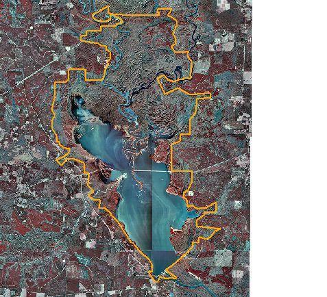
2 Sam Rayburn Reservoir
3
4 What s In A Name? Sam Rayburn Dam and Reservoir MaGee Bend Reservoir Sam Rayburn Powerhouse Town Bluff Project Dam B B. A. Steinhagen Lake R. D. Willis Powerhouse
5 Sam Rayburn Reservoir Gates closed in 1965 Largest reservoir totally in Texas 114,000 surface acres Only significant lake on the Angelina River Normal elevation 164.4, TOD 190.0, spillway elevation Twin generators with floodgates
6 TOWN BLUFF PROJECT Closed gates in Southernmost project in group of 4 authorized in 1946 for Neches River Dam A, Dam B, Rockland, MaGee Bend only other project completed was Sam Rayburn in Hydropower added in Average depth is 5 7 feet.
7 TOWN BLUFF PROJECT Top of gates and uncontrolled spillway 85 feet NGVD. Normal operation range NGVD. Elevation required for operation of powerhouse 76 NGVD. Covers approximately 11,500 acres at 83 NGVD. Contains over 94,000 acre-feet at capacity.

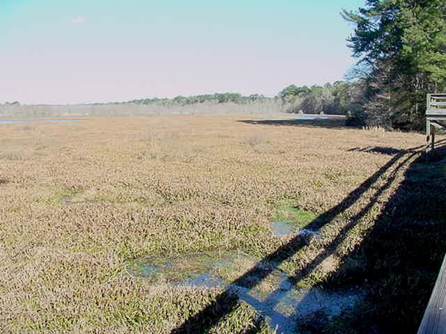
8 Town Bluff Project

9 Town Bluff Project

10 Town Bluff Project

11 Town Bluff Project

12 Town Bluff Project

13 Town Bluff Project

14 Town Bluff Project

15 Town Bluff Project
16

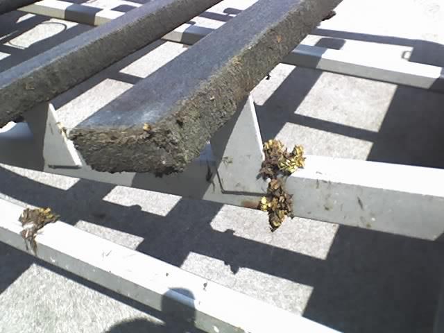
17 Giant Salvinia
18
19

20 Town Bluff Project
21
22
23
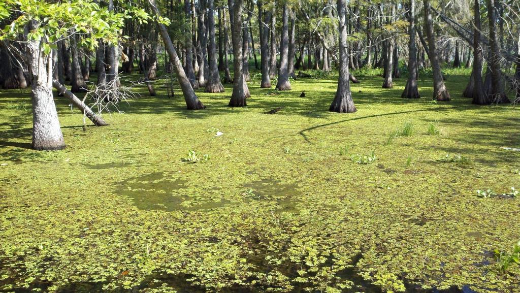
24 Why This Project Has Problems High nutrient inflow Shallow water Hot summers and mild winters Lack of wave action due to high presence of emergent woody vegetation (cypress, willow, buttonbush) Numerous sloughs and oxbows that act as banks and nurseries for vegetation Relatively stable lake level.
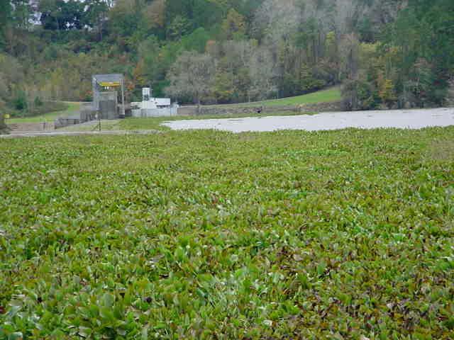
25 CONTROL METHODS Mechanical logistically difficult and very expensive. Hard to stay ahead of growth rate during summer. Not practical. Biological Water Hyacinth beetle, Alligatorweed Flea Beetle, Salvinia Weevil, Hydrilla Fly. Not cold-hardy. Chemical expensive and not effective alone.
26 CONTOL METHODS Winter drawdown has been tried over last decade with limited success. Effect usually gone by late summer. Lake only dropped to elev. 76 to allow for generation. Summer drawdown was used often before addition of powerhouse with good success. It is the method proposed by both TPWD and COE. Target elevation would be around 60 and duration would be June September. Major drawback is no generation possible.

27 Plan of Attack Corps of Engineers Lower Neches Valley Authority Texas Parks and Wildlife Southwestern Power Administration Lewisville Aquatic Environmental Research Facility SFASU
28 2006 Plan of Attack Draw down lake to elevation 76 from June 15 July 31. Fully drain lake from August 1 September 15. Use aerial herbicide applications during drawdown to eliminate pockets of vegetation. TPWD survey after lake reaches full pool. Press Release


29 Control Measure - Drawdown
30 Plan of Attack MOU TPWD, LNVA, COE (2007) Nuisance Aquatic Vegetation Management Plan, B. A. Steinhagen Reservoir, Aquatic Vegetation Treatment Proposals Educational/Warning Signs Vegetation Barriers Dedicated airboat spraying crew (LNVA) Yearly survey, revisions (TPWD)

31 Sam Rayburn GS 2009

32 Sam Rayburn GS 2009


33 Control Measure Education/Warning Sign
34

35 Control Measure - Vegetation Barrier

36 SH 103 Vegetation Barrier

37 2007 Spraying

38 Control Measure - Airboat Rake

39 Airboat Rake

40 Manual Spraying

41 Control Measure - Aerial Spraying Dam B

42 Control Measure - Airboat Spraying

43 Control Measure - Biological Salvinia Weevils Hyacinth Beetles Alligatorweed Flea Beetles Hydrilla Flies Grass Carp

44 Wait and See

45 As the Grass Grows
Aquatic Invasive Species Initiatives in Texas. Luci Cook-Hildreth Texas Parks and Wildlife Dept.
 Aquatic Invasive Species Initiatives in Texas Luci Cook-Hildreth Texas Parks and Wildlife Dept. Aquatic Invasive Species in Texas Aquaculture Aquarium Releases Riparian Invasive Species Zebra Mussels Aquatic
2017 Annual Report: Survey pf American Alligators (Alligator mississippiensis) in the Big Thicket National Preserve. Summary.
 in the Big Thicket National Preserve. Summary.") 2017 Annual Report: Survey pf American Alligators (Alligator mississippiensis) in the Big Thicket National Preserve Matthew I. Pyne Assistant Professor, Department of Biology, Lamar University, P.O. Box
2017 Annual Report: Survey pf American Alligators (Alligator mississippiensis) in the Big Thicket National Preserve Matthew I. Pyne Assistant Professor, Department of Biology, Lamar University, P.O. Box
Aquatic Plant Management and Importance to Sport Fisheries
 Aquatic Plant Management and Importance to Sport Fisheries Presentation to Michigan Inland Lakes Convention May 2014 Mike Maceina Professor Emeritus School of Fisheries, Aquaculture, and Aquatic Sciences
Regulations. Grabbling season May 1 July 15; only wooden structures allowed.
 Arkabutla Reservoir 219 REEL FACTS Keith Meals, Arthur Dunn, Stanley Turner Fisheries Biologists keithm@wfp.ms.gov, ArthurD@wfp.ms.gov, StanleyT@wfp.ms.gov General Information: Arkabutla Reservoir is one
Tunica Cutoff 2018 REEL FACTS Keith Meals Fisheries Biologist
 Tunica Cutoff 218 REEL FACTS Keith Meals Fisheries Biologist keithm@mdwfp.state.ms.us General Information: Tunica Cutoff was created by the US Army Corps of Engineers (COE) in 1942 when a bend in the Mississippi
located Let s go fishing Hydrilla
 Our Lake of the Month for November is Lake August (set your GPS to 27.2750-81.4136). The elevation of Lake August is 102.5. Lake August is a 52 acre dredge hole lake (man-made from a former wetland; see
STRUCTURAL STABILITY ASSESSMENT
 STRUCTURAL STABILITY ASSESSMENT CFR 257.73(d) Fly Ash Reservoir II Cardinal Plant Brilliant, Ohio October, 2016 Prepared for: Cardinal Operating Company Cardinal Plant Brilliant, Ohio Prepared by: Geotechnical
Regulations. Grabbling season May 1 July 15; only wooden structures allowed.
 Grenada Reservoir 218 REEL FACTS Keith Meals, Arthur Dunn, Stanley Turner Fisheries Biologists keithm@mdwfp.state.ms.us, ArthurD@mdwfp.state.ms.us, StanleyT@mdwfp.state.ms.us General Information: Grenada
FACT SHEET MCGREGOR LAKE RESTORATION HABITAT PROJECT POOL 10, UPPER MISSISSIPPI RIVER, WISCONSIN ENVIRONMENTAL MANAGEMENT PROGRAM
 FACT SHEET MCGREGOR LAKE RESTORATION HABITAT PROJECT POOL 10, UPPER MISSISSIPPI RIVER, WISCONSIN ENVIRONMENTAL MANAGEMENT PROGRAM LOCATION McGregor Lake is located within a mid-river island in Pool 10
Regulations. Grabbling season May 1 July 15; only wooden structures allowed.
 Enid Reservoir 218 REEL FACTS Keith Meals, Arthur Dunn, Stanley Turner Fisheries Biologists keithm@mdwfp.state.ms.us, ArthurD@mdwfp.state.ms.us, StanleyT@mdwfp.state.ms.us General Information: Enid Reservoir
Kerr Lake Vegetation Survey. October November Report submitted by NC State University. Background
 Kerr Lake Vegetation Survey October November 2012 Report submitted by NC State University Background Hydrilla (Hydrilla verticillata) is a non-native invasive submersed aquatic plant. This plant was first
Regulations. Grabbling season May 1 July 15; only wooden structures allowed.
 Sardis Reservoir 218 REEL FACTS Keith Meals, Arthur Dunn, Stanley Turner Fisheries Biologists keithm@mdwfp.state.ms.us, ArthurD@mdwfp.state.ms.us, StanleyT@mdwfp.state.ms.us General Information: Sardis
BASELINE SURVEY OF AQUATIC PLANTS LAKE MURRAY, SC 2007
 BASELINE SURVEY OF AQUATIC PLANTS LAKE MURRAY, SC 2007 Prepared for: South Carolina Electric & Gas Company prepared by: Cynthia A. Aulbach Botanical Services of South Carolina Lexington, SC 29072 December
LAKE TANEYCOMO 2011 ANNUAL LAKE REPORT
 LAKE TANEYCOMO 211 ANNUAL LAKE REPORT Shane Bush Fisheries Management Biologist Missouri Department of Conservation Southwest Region March 1, 212 EXECUTIVE SUMMARY Lake Taneycomo was formed by the construction
Name of Applicant Phone Number # Mailing Address. City State Zip
 VIRGINIA DEPARTMENT OF GAME AND INLAND FISHERIES EXOTIC SPECIES APPLICATION/PERMIT TO IMPORT CERTIFIED TRIPLOID GRASS CARP FOR AQUATIC VEGETATION CONTROL IN PRIVATE PONDS (Under Authority of 4 VAC 15-30-40
Columbia Lake Dam Removal Project
 Columbia Lake Dam Removal Project The Columbia Lake dam located 1/4 mile upstream of the Paulins Kill River's confluence with the Delaware River in Knowlton Township, Warren County has been proposed for
Water Resources Report RKLD Annual Meeting July 30, 2016
 Water Resources Report RKLD Annual Meeting 2016 July 30, 2016 Topics Hydrology Report Indianford Dam trash rack cleanout performance Experimental Project update Review of PAS project Twin floods- 1 to
Pond Management. Dan Lekie Agriculture & Natural Resource Agent K-State Research & Extension Johnson County
 Pond Management Dan Lekie Agriculture & Natural Resource Agent K-State Research & Extension Johnson County Pond Management Basics Plant ID and Control Fish Management Wildlife Concerns Management Options
USING A LABYRINTH WEIR TO INCREASE HYDRAULIC CAPACITY. Dustin Mortensen, P.E. 1 Jake Eckersley, P.E. 1
 USING A LABYRINTH WEIR TO INCREASE HYDRAULIC CAPACITY Dustin Mortensen, P.E. 1 Jake Eckersley, P.E. 1 Plum Creek Floodwater Retarding Structure No. 6 is located in an area of Kyle, Texas, that is currently
Fisheries Resources in White Pine County
 Fisheries Resources in White Pine County June 22, 2013 Update to the Nevada Board of Wildlife Commissioners Jon C. Sjöberg Chief of Fisheries Comins Lake Located 7 miles south of Ely. Built in 1953 as
Big Spring Creek Habitat Enhancement and Fishery Management Plans
 Big Spring Creek Habitat Enhancement and Fishery Management Plans November 5, 2012 Big Spring Events and Activities Center Newville, PA Charlie McGarrell Regional Habitat Biologist Pennsylvania Fish and
CLAIBORNE LOCK AND DAM PERTINENT DATA
 CLAIBORNE LOCK AND DAM PERTINENT DATA GENERAL Location Clarke, Monroe, & Wilcox Counties, Alabama; Alabama River, river mile 72.5 Drainage area Millers Ferry to Claiborne sq. mi. 836 Total drainage area
FINAL Caples Lake Fisheries Management Plan. Version 4.0
 FINAL Caples Lake Fisheries Management Plan Version 4.0 August 15, 2008 Purpose The Caples Lake Fisheries Management Plan (Plan) outlines the stocking plan to reestablish a sport fishery in Caples Lake
NEVADA DEPARTMENT OF WILDLIFE STATEWIDE SPORT FISHERIES MANAGEMENT
 NEVADA DEPARTMENT OF WILDLIFE STATEWIDE SPORT FISHERIES MANAGEMENT FEDERAL AID JOB PROGRESS REPORT F-20-53 2017 RUBY MOUNTAIN & EAST HUMBOLDT HIGH MOUNTAIN LAKES NEVADA DEPARTMENT OF WILDLIFE, FISHERIES
Estimated on-the-ground start and end dates: 1 June October 2018
 A. Applicant Information Name of Organization: U.S. Army Corps of Engineers, Carlyle Lake 801 Lake Road, Carlyle, IL 62231 Contact Information: Robert Wilkins, Operations Manager, (618) 594-2484, Robert.Wilkins@usace.army.mil
NEVADA DEPARTMENT OF WILDLIFE STATEWIDE FISHERIES MANAGEMENT
 NEVADA DEPARTMENT OF WILDLIFE STATEWIDE FISHERIES MANAGEMENT FEDERAL AID JOB PROGRESS REPORTS F-2-52 216 CHIMNEY RESERVOIR WESTERN REGION NEVADA DEPARTMENT OF WILDLIFE, FISHERIES DIVISION JOB PROGRESS
Enclosure 9. Memorandum for Record, meeting with FWS on August 12, 2002
 Enclosure 9 Memorandum for Record, meeting with FWS on August 12, 2002 CESAM-PD-EI Brandt/690-3260/23 August 2002 MEMORANDUM FOR RECORD SUBJECT: Meeting with USFWS and FWCC to Discuss ACF Water Control
LOUISIANA DEPARTMENT OF WILDLIFE & FISHERIES
 LOUISIANA DEPARTMENT OF WILDLIFE & FISHERIES OFFICE OF FISHERIES INLAND FISHERIES SECTION PART VI B WATERBODY MANAGEMENT PLAN SERIES LAKE FIELDS-LAKE LONG COMPLEX WATERBODY EVALUATION & RECOMMENDATIONS
Regulations. Grabbling season May 1 July 15; only wooden structures allowed.
 Sardis Reservoir 19 REEL FACTS Keith Meals, Arthur Dunn, Stanley Turner Fisheries Biologists keithm@wfp.ms.gov, ArthurD@wfp.ms.gov, StanleyT@wfp.ms.gov General Information: Sardis Reservoir is one of four
MIDDLE FORK RESERVOIR Wayne County 2004 Fish Management Report. Christopher C. Long Assistant Fisheries Biologist
 MIDDLE FORK RESERVOIR Wayne County 2004 Fish Management Report Christopher C. Long Assistant Fisheries Biologist FISHERIES SECTION INDIANA DEPARTMENT OF NATURAL RESOURCES DIVISION OF FISH AND WILDLIFE
PRELIMINARY RISK ASSESSMENT RIDM PROJECT FOR A DAM WITH A VEGETATION- LINED SPILLWAY AND FERC PILOT
 PRELIMINARY RISK ASSESSMENT FOR A DAM WITH A VEGETATION- LINED SPILLWAY AND FERC PILOT RIDM PROJECT MAY 3, 2018 DAVID S. BOWLES AND LOREN R. ANDERSON RAC ENGINEERS AND ECONOMISTS, LLC AND UTAH STATE UNIVERSITY
Crawford Reservoir. FISH SURVEY AND MANAGEMENT INFORMATION Eric Gardunio, Fish Biologist Montrose Service Center
 FISH SURVEY AND MANAGEMENT INFORMATION General Information: Crawford Reservoir is a popular fishery that provides angling opportunity for yellow perch, channel catfish, northern pike, rainbow trout, black
LOUISIANA DEPARTMENT OF WILDLIFE & FISHERIES
 LOUISIANA DEPARTMENT OF WILDLIFE & FISHERIES OFFICE OF FISHERIES INLAND FISHERIES SECTION PART VI -B WATERBODY MANAGEMENT PLAN SERIES HENDERSON LAKE WATERBODY EVALUATION & RECOMMENDATIONS CHRONOLOGY DOCUMENT
SKIATOOK LAKE MANAGEMENT PLAN
 SKIATOOK LAKE MANAGEMENT PLAN Background Skiatook Lake impounds Hominy Creek, 5 miles west of Skiatook in Osage County, Oklahoma (Figure 1). Skiatook Lake covers 10,540 surface acres and was constructed
5B. Management of invasive species in the Cosumnes and Mokelumne River Basins
 5B. Management of invasive species in the Cosumnes and Mokelumne River Basins Cosumnes River The Cosumnes River basin has a number of distinct habitat types that require different management strategies
CARL BLACKWELL LAKE MANAGEMENT PLAN
 CARL BLACKWELL LAKE MANAGEMENT PLAN Background Lake Carl Blackwell impounds Stillwater Creek, 10 miles west of Stillwater in Payne County, Oklahoma (Figure 1). The lake covers 3,370 surface acres and was
Management Plan for the Obey River Trout Fishery
 Management Plan for the Obey River Trout Fishery 28-214 By: James Travis Scott Jack Swearengin Walter Scott Webb D.W. Young Tennessee Wildlife Resources Agency January 28 Management Plan for the Obey River
Interactions between fish and aquatic macrophytes in inland waters
 Page 1 of 6 Produced by: Fisheries and Aquaculture Department Title: Interactions between fish and aquatic macrophytes in inland waters. A review... More details FAO FISHERIES TECHNICAL PAPER 396 Interactions
Upper/Lower Owl Creek Reservoir
 Upper/Lower Owl Creek Reservoir Schuylkill County 2018 Largemouth Bass Survey Upper Owl Creek Reservoir and Lower Owl Creek Reservoir are 67-acre and 26-acre impoundments, respectively, created by two
Istokpoga Newswire Article Index
 Newswire Article Index Issue Year Month Page Article Name Author 38 2008 November 1-2 NEEPP - Northern Everglades & Estuaries Protection Program Bert Galloway, President FOI 38 2008 November 2-3 What s
Overview of Recreational Pond Management
 Overview of Recreational Pond Management extension November 13 th 2013 Forrest Wynne State Extension Specialist for Aquaculture Kentucky State University Ponds are built for some of the following purposes:
Emergent Sandbar Habitat Program Middle Missouri River
 Emergent Sandbar Habitat Program Middle Missouri River Jeremiah Szynskie, P.E. Hydrologic Engineering Branch Introduction Main Stem System Dam Closures Fort Peck 1937 Fort Randall 1952 Garrison - 1953
Illinois Lake Management Association Conference March 23, 2018 By Trent Thomas Illinois Department of Natural Resources Division of Fisheries
 Illinois Lake Management Association Conference March 23, 2018 By Trent Thomas Illinois Department of Natural Resources Division of Fisheries Sources of Habitat Impairment Sedimentation Channelization
Columbia Lake Dam Removal Project
 Columbia Lake Dam Removal Project Major Goals of the Columbia Lake Dam Removal: Reconnect 10 miles of the Paulins Kill River to the Delaware River, restoring natural flow regime and sediment transport.
COLUMBIA LAKE DAM REMOVAL PROJECT
 COLUMBIA LAKE DAM REMOVAL PROJECT Major Goals of the Columbia Lake Dam Removal: Reconnect 10 miles of the Paulins Kill River to the Delaware River, restoring natural flow regime and sediment transport.
Willamette River Oregon Chub
 Willamette River Oregon Chub Interim Risk Assessment Oregon chub (Oregonichthys crameri), small minnows endemic to the Willamette Valley, were federally listed as endangered under the Endangered Species
Starry Stonewort in Silver Lake Washington County, WI BRAD STECKART AIS COORDINATOR FOR WASHINGTON AND WAUKESHA COUNTIES
 Starry Stonewort in Silver Lake Washington County, WI BRAD STECKART AIS COORDINATOR FOR WASHINGTON AND WAUKESHA COUNTIES Brad Steckart -AIS coordinator for Washington and Waukesha Counties -Graduated from
An Assessment of the Fish Community in Lake Acworth
 An Assessment of the Fish Community in Lake Acworth By John Damer Fisheries Biologist Georgia Department of Natural Resources Wildlife Resources Division Fisheries Section Calhoun, GA 30701 July 2008 Introduction
Everything a Lake Should Be
 Everything a Lake Should Be It's not what we do that sets us apart. It's how and why we do it so well. RESPONSIBLE LAKE MANAGEMENT Since 1977, Aquatic Systems has been solving difficult waterway management
Aquatic Biological Assessment. Lassen 15 Restoration Project. Modoc National Forest Warner Mountain Ranger District
 Aquatic Biological Assessment Lassen 15 Restoration Project Modoc National Forest Warner Mountain Ranger District Prepared By:_/s/ Marty Yamagiwa Date: December 10, 2015 Marty Yamagiwa, Natural Resources
Moon Lake 2018 REEL FACTS Nathan Aycock - Fisheries Biologist (601)
") Moon Lake 18 REEL FACTS Nathan Aycock - Fisheries Biologist NathanA@mdwfp.state.ms.us (61) 43- General Information: Moon Lake is a,3 acre oxbow lake of the Mississippi River. The primary inflow to the
Moon Lake 18 REEL FACTS Nathan Aycock - Fisheries Biologist NathanA@mdwfp.state.ms.us (61) 43- General Information: Moon Lake is a,3 acre oxbow lake of the Mississippi River. The primary inflow to the
Managing a Quality Pond
 Managing a Quality Pond Gary Burtle The University of Georgia Successful Pond Management Set your GOAL Pond design Stocking Strategy Proper Nutrients Fish Growth and Harvest Successful Fish Reproduction
INFILTRATION PRACTICE MAINTENANCE INSPECTION FORM
 Facility Number: Date: Time: Subdivision Name: Watershed: Weather: Inspector(s): Date of Last Rainfall: Amount: Inches Streets: Mapbook Location: GPS Coordinates: Property Classification: Residential 9
California Steelhead: Management, Monitoring and Recovery Efforts
 California Steelhead: Management, Monitoring and Recovery Efforts Jonathan Nelson Steelhead Restoration & Management Program Oncorhynchus mykiss irideus California Steelhead Distinct Population Segments
Pickwick Lake 2018 REEL FACTS Trevor Knight Fisheries Biologist (662)
") Pickwick Lake 218 REEL FACTS Trevor Knight Fisheries Biologist trevork@mdwfp.state.ms.us (662) 84-5176 General Information: Covering 43,1 acres, Pickwick Lake, which borders Alabama, Tennessee, and Mississippi,
Pickwick Lake 218 REEL FACTS Trevor Knight Fisheries Biologist trevork@mdwfp.state.ms.us (662) 84-5176 General Information: Covering 43,1 acres, Pickwick Lake, which borders Alabama, Tennessee, and Mississippi,
National Wildlife Refuge System
 Eufaula National Wildlife Refuge part of the US Department of the Interior US Fish and Wildlife Service National Wildlife Refuge System What is the National Wildlife Refuge System? Our Mission: The mission
Restoring a Recreational Gem. Pete Jopke Water Resources Planner Dane County Land & Water Resources Department
 Restoring a Recreational Gem Pete Jopke Water Resources Planner Dane County Land & Water Resources Department Lake Park Association 1912 Land purchased, road constructed and dam built Late Fall 1912 January
DALE HOLLOW LAKE TROOPER ISLAND IMPROVEMENT PROJECT Proposal for Reservoir Fisheries Habitat Partnership (RFHP)
") DALE HOLLOW LAKE TROOPER ISLAND IMPROVEMENT PROJECT Proposal for Reservoir Fisheries Habitat Partnership (RFHP) A. Applicant Information: US Army Corps of Engineers, Dale Hollow Lake POC: Gregg Nivens
DALE HOLLOW LAKE TROOPER ISLAND IMPROVEMENT PROJECT Proposal for Reservoir Fisheries Habitat Partnership (RFHP) A. Applicant Information: US Army Corps of Engineers, Dale Hollow Lake POC: Gregg Nivens
HOT SPRINGS VILLAGE LAKES
 HOT SPRINGS VILLAGE LAKES BILL STAGGS PUBLIC WORKS DIRECTOR BRADLEY J. MEREDITH LAKES ECOLOGY & FISHERIES MANAGER Photos by Bradley J. Meredith and Katy Harmon LAKES IMPROVEMENT PLAN STAFFING CAPITAL IMPROVEMENTS
Economics of Large (>200 anglers) Fishing Tournaments at Lake Fork, Texas
 Fishing Tournaments at Lake Fork, Texas") Economics of Large (>200 anglers) Fishing Tournaments at Lake Fork, Texas Dan Bennett*, Kevin Storey, and Todd Driscoll Texas Parks and Wildlife Inland Fisheries Division Dan.Bennett@tpwd.texas.gov An
Economics of Large (>200 anglers) Fishing Tournaments at Lake Fork, Texas Dan Bennett*, Kevin Storey, and Todd Driscoll Texas Parks and Wildlife Inland Fisheries Division Dan.Bennett@tpwd.texas.gov An
MARTINDALE POND Wayne County 2004 Fish Management Report. Christopher C. Long Assistant Fisheries Biologist
 MARTINDALE POND Wayne County 2004 Fish Management Report Christopher C. Long Assistant Fisheries Biologist Fisheries Section Indiana Department of Natural Resources Division of Fish and Wildlife I.G.C.
Frequently Asked Questions About Revised Critical Habitat and Economic Analysis for the Endangered Arroyo Toad
 Q Frequently Asked Questions About Revised Critical Habitat and Economic Analysis for the Endangered Arroyo Toad Q. What is the arroyo toad? The arroyo toad (Bufo californicus) is a small, light greenish-grey
Monitoring of Downstream Fish Passage at Cougar Dam in the South Fork McKenzie River, Oregon February 8, By Greg A.
 Monitoring of Downstream Fish Passage at Cougar Dam in the South Fork McKenzie River, Oregon 1998- February 8, 2 By Greg A. Taylor Oregon Dept. of Fish & Wildlife 315 E. Main Street Springfield, OR 97478
NEVADA DEPARTMENT OF WILDLIFE STATEWIDE FISHERIES MANAGEMENT
 NEVADA DEPARTMENT OF WILDLIFE STATEWIDE FISHERIES MANAGEMENT FEDERAL AID JOB PROGRESS REPORTS F-20-50 2014 ELKO COUNTY SMALL LAKES AND RESERVOIRS EASTERN REGION NEVADA DEPARTMENT OF WILDLIFE, FISHERIES
*A Certificate of Survey for the property may be on file at City Hall if the house was built after 1984.
 Swimming Pools ** Permits are required for pools having a water surface area exceeding 100 square feet ** Permits are required for pools having a water surface area exceeding 100 square feet (11-3-3/8
Moon Lake 2019 REEL FACTS Nathan Aycock - Fisheries Biologist (601)
") Moon Lake 19 REEL FACTS Nathan Aycock - Fisheries Biologist NathanA@mdwfp.state.ms.us (61) 43- General Information: Moon Lake is a,3 acre oxbow lake of the Mississippi River. The primary inflow to the
Moon Lake 19 REEL FACTS Nathan Aycock - Fisheries Biologist NathanA@mdwfp.state.ms.us (61) 43- General Information: Moon Lake is a,3 acre oxbow lake of the Mississippi River. The primary inflow to the
Mud Bay SLELO-PRISM Water Chestnut & Hydrilla Surveillance 2012
 St. Lawrence Eastern Lake Ontario Partnership for Regional Invasive Species Management Mud Bay Water Chestnut & Hydrilla Surveillance 2012 June 27 th (Water Chestnut) & August 2 (Hydrilla), 2012 Figure
AMERICAN FISHERIES SOCIETY HUMBOLDT CHAPTER CALIFORNIA-NEVADA CHAPTER 1990 NORTHEAST PACIFIC CHINOOK & COHO SALMON WORKSHOP PROCEEDINGS
 AMERICAN FISHERIES SOCIETY HUMBOLDT CHAPTER CALIFORNIA-NEVADA CHAPTER 1990 NORTHEAST PACIFIC CHINOOK & COHO SALMON WORKSHOP PROCEEDINGS ENVIRONMENTAL FACTORS CONTRIBUTING TO THE DECLINE OF THE WINTER-RUN
CLOSURE PLAN. CFR (b) Bottom Ash Pond Complex Cardinal Plant Brilliant, Ohio. September, 2016
 Bottom Ash Pond Complex Cardinal Plant Brilliant, Ohio. September, 2016") CLOSURE PLAN CFR 257.102(b) Bottom Ash Pond Complex Cardinal Plant Brilliant, Ohio September, 2016 Prepared for: Cardinal Operating Company Cardinal Plant Brilliant, Ohio Prepared by: Geotechnical Engineering
CLOSURE PLAN CFR 257.102(b) Bottom Ash Pond Complex Cardinal Plant Brilliant, Ohio September, 2016 Prepared for: Cardinal Operating Company Cardinal Plant Brilliant, Ohio Prepared by: Geotechnical Engineering
Applying Engineering Solutions to the Science of Invasive Aquatic Species Control Asian Carp and Sea Lamprey. Bill Holman, P.E. Stanley Consultants
 Applying Engineering Solutions to the Science of Invasive Aquatic Species Control Asian Carp and Sea Lamprey Bill Holman, P.E. Stanley Consultants Sea Lamprey: Great Lakes Invader Lake Superior Sea Lamprey
1.Mill Creek Watershed Summary Description and Land Use
 1.Mill Creek Watershed Summary Description and Land Use Table xxx: Mill Creek Watershed Overview Watershed Size 31,435 acres/49.1 sq miles/ 127.1 sq km Elevation Range 5,594 feet [4,967-10,561] Stream
APPENDIX C VEGETATED EMERGENCY SPILLWAY. VERSION 1.0 March 1, 2011
 APPENDIX C VEGETATED EMERGENCY SPILLWAY VERSION 1.0 March 1, 2011 [NOTE: Could use a better photo more clearly showing the emergency spillway in the context of the dam.] SECTION C-1: DESCRIPTION OF PRACTICE
Rob Tewes Senior Aquatic Biologist; ORSANCO. The Ohio River Valley Water Sanitation Commission (ORSANCO) Biological and Research Programs
 Biological and Research Programs") Rob Tewes Senior Aquatic Biologist; ORSANCO Background The Ohio River has been subject to invasions from exotic aquatic species since at least the mid to late 1800 s when Common Carp began gaining a foot-hold
Rob Tewes Senior Aquatic Biologist; ORSANCO Background The Ohio River has been subject to invasions from exotic aquatic species since at least the mid to late 1800 s when Common Carp began gaining a foot-hold
LCCMR Work Program Final Report. Total Biennial Project Budget
 Overall Report Page 81 of 208 2H:Fish Habitat - MN DNR - Division of Fisheries Project Manager: Affiliation: Address: Phone: Fax: E-mail: Linda Erickson-Eastwood MN DNR - Division of Fisheries 500 Lafayette
Osoyoos Lake Aquatic Plant Mapping
 Osoyoos Lake Aquatic Plant Mapping AquaTechnex, LLC Presented to Okanogan County NWCB by PO Box 30824 Bellingham WA, 98228 www.aquatechnex.com Introductions Myriophyllum spicatum or Eurasian Milfoil has
Lake wide Milfoil Management Efforts
 Lake Winnipesaukee Lake wide Milfoil Management Efforts Gilford Island Association Winter Meeting March 5, 2016 Presented by: Patricia Tarpey Lake Winnipesaukee Association Gilford Conservation Commission
DEPARTMENT OF THE ARMY SOUTH ATLANTIC DIVISION, CORPS OF ENGINEERS ROOM 9M15, 60 FORSYTH ST., S.W. ATLANTA GA
 DEPARTMENT OF THE ARMY SOUTH ATLANTIC DIVISION, CORPS OF ENGINEERS ROOM 9M15, 60 FORSYTH ST., S.W. ATLANTA GA 30303-8801 REPLY TO ATTENTION OF SADR PDS-O-1 CESAD-PDS-R/PDS-O 31 May 2010 Regulation No.
Ben Powell Clemson Extension
 Ben Powell Clemson Extension Maintain biological balance of the aquatic food web Serve as a functional reservoir for nutrients (and toxins) Provide control for aquatic weeds and biting flies Food source
2016 Field Survey Oneida Lake / Three Mile Bay WMA SLELO-PRISM Early Detection Surveillance
 St. Lawrence Eastern Lake Ontario Partnership for Regional Invasive Species Management 2016 Field Survey Oneida Lake / Three Mile Bay WMA Early Detection Surveillance August 3 rd, 4 th, 5 th, and 8 th,
Below the Surface: Aquatic Invasives
 Below the Surface: Aquatic Invasives DATE AND TIME SPEAKER(S) Thursday, 25 February 2010 / 10AM-1130AM Doug Keller Aquatic Invasive Species Coordinator Indiana DNR, Division of Fish and Wildlife 402 W.
Honorable Mayor and Members of the City Council SUBJECT: 2008 REPORT FROM THE TEHAMA COUNTY MOSQUITO AND VECTOR CONTROL DISTRICT
 AGENDA REPORT Meeting Date: March 17, 2009 Agenda Item # City Manager Approval: TO: Honorable Mayor and Members of the City Council FROM: MARTIN J. NICHOLS City Manager SUBJECT: 2008 REPORT FROM THE TEHAMA
DRIPPING SPRINGS LAKE 5 YEAR LAKE MANAGEMENT PLAN
 DRIPPING SPRINGS LAKE 5 YEAR LAKE MANAGEMENT PLAN FISHERIES DIVISION CENTRAL REGION OKLAHOMA DEPTMENT OF WILDLIFE CONSERVATION PREPARED BY: DANNY BOWEN OCTOBER 2013 1 Background Dripping Springs Lake impounds
Research Grant Application Barnstead Milfoil Committee Suncook River Milfoil Removal Study
 07-08 Suncook River Milfoil Removal Study A. Brief Description: The, Center Barnstead, NH is submitting a proposal to the NH Department of Environmental Services to develop a procedure and study the results
State of Texas Operations and Maintenance
 State of Texas Operations and Maintenance Barbour Terminal Ship Channel The Barbour Terminal Channel and Turning Basin is a 1.7-mile-long deep draft waterway that extends from the Houston Ship Channel
f Agricultural S c i e n c SMALL EARTH DAMS LLOYD N. BROWN ^ CALIFORNIA AGRICULTURAL CIRCULAR 467 \ Experiment Station Extension Service
 f Agricultural S c i e n c SMALL EARTH DAMS LLOYD N. BROWN ^ CALIFORNIA AGRICULTURAL \ Experiment Station Extension Service CIRCULAR 467 Crest of dam Dry face slope 2 to 1 Downstream toe About 10,000 small
NURSERY POND Fish Management Report. Jason C. Doll Assistant Fisheries Biologist
 NURSERY POND 2004 Fish Management Report Jason C. Doll Assistant Fisheries Biologist FISHERIES SECTION INDIANA DEPARTMENT OF NATURAL RESOURCES DIVISION OF FISH AND WILDLIFE I.G.C. South, Room W273 402
DRAFT MEMORANDUM TO FILE
 FROM: SUBJECT: DRAFT MEMORANDUM TO FILE Unique Stream Segment Committee File [NTD02182] T:\Task 8 - Unique Designations and Regulatory Issues\Draft Committee Memo.doc Summary of Regional Water Planning
EUFAULA LAKE 5 YEAR LAKE MANAGEMENT PLAN
 EUFAULA LAKE 5 YEAR LAKE MANAGEMENT PLAN FISHERIES DIVISION CENTRAL REGION OKLAHOMA DEPTMENT OF WILDLIFE CONSERVATION PREPARED BY: DANNY BOWEN SEPTEMBER 15, 2008 1 Background Eufaula Lake is located on
Kissimmee River Channelization
 Environmental Restoration ti Update Phil Flood, South Florida Water Management District Presentation Overview Kissimmee River Restoration Everglades Stormwater Treatment Areas Comprehensive Everglades
Session B8- Monitoring changes in diadromous populations resulting from fish passage improvements on the Acushnet River, Massachusetts
 University of Massachusetts - Amherst ScholarWorks@UMass Amherst International Conference on Engineering and Ecohydrology for Fish Passage International Conference on Engineering and Ecohydrology for Fish
Basemap Data Collection for Ash Pond Closure Designs: Topographic and Bathymetric Challenges
 2015 World of Coal Ash (WOCA) Conference in Nasvhille, TN - May 5-7, 2015 http://www.flyash.info/ Basemap Data Collection for Ash Pond Closure Designs: Topographic and Bathymetric Challenges David Reynolds,
SOONER LAKE MANAGEMENT PLAN
 SOONER LAKE MANAGEMENT PLAN Background Lake Sooner impounds Greasy Creek, 15 miles south of Ponca City in Noble and Pawnee Counties, Oklahoma (Figure 1). The Grease Creek basin that Sooner Lake impounds
natural low-water ' conditionson tamed Mississippi, new life springs, up Vl ' V ' ' - "
 When an experiment mimics natural low-water ' conditionson tjhe tamed Mississippi, new life springs, up in the \ backwaters. Vl ' V ' ' - " y *.»* ' ' ' - ' ' by JASON ABRAHAM Common map turtle Mississippi
WFC 50 California s Wild Vertebrates Jan. 11, Inland Waters (Lakes and Streams) Lisa Thompson
 Lisa Thompson") Inland Waters: Lakes and Streams WFC 50 11 January 2011 Lisa Thompson Fisheries Extension Specialist Wildlife, Fish, & Conservation Biology Department University of California, Davis Take home messages
Inland Waters: Lakes and Streams WFC 50 11 January 2011 Lisa Thompson Fisheries Extension Specialist Wildlife, Fish, & Conservation Biology Department University of California, Davis Take home messages
BLACK WARRIOR-TOMBIGBEE RIVER
 MILE 215 BAR Tenn-Tom Waterway 214 Foscue Creek Foscue Creek Boat Ramp Demopolis Resource Office & Coast Guard Station Damsite (2600 Acres) Demopolis Lock & Dam DEMOPOLIS LOCK UA Demopolis L&D/Foscue Creek
HEC-RAS Two-Dimensional Modeling: Lake Wausau, Wisconsin River and Tributaries Big Rib River and Eau Claire River January 2018
 Final Report HEC-RAS Two-Dimensional Modeling: Lake Wausau, Wisconsin River and Tributaries Big Rib River and Eau Claire River City of Schofield, City of Wausau, Town of Rib Mountain, and Village of Rothschild,
BLACK WARRIOR-TOMBIGBEE RIVER
 Tenn-Tom Waterway 214 Foscue Creek Boat Ramp Foscue Creek Demopolis Resource Office & Coast Guard Station Damsite (2600 Acres) Demopolis Lock & Dam DEMOPOLIS LOCK UA Demopolis L&D/Foscue Creek (537.6 Acres)
RED RIVER NATIONAL WILDLIFE REFUGE
 RED RIVER NATIONAL WILDLIFE REFUGE http://www.fws.gov/refuge/red_river/ https://www.facebook.com/redrivernwr Photograph of wood ducks taken on Refuge by volunteer Ronnie Maum Wildlife Quiz 4 Bird Species
LOUISIANA DEPARTMENT OF WILDLIFE & FISHERIES
 LOUISIANA DEPARTMENT OF WILDLIFE & FISHERIES OFFICE OF FISHERIES INLAND FISHERIES SECTION PART VI -A WATERBODY MANAGEMENT PLAN SERIES LAKE FIELDS, LAKE LONG COMPLEX HISTORY & MANAGEMENT ISSUES November
Aquatic Invasive Species : Update on AIS related efforts at Deep Creek Lake, Maryland
 Aquatic Invasive Species : Update on AIS related efforts at Deep Creek Lake, Maryland Presentation to the DCL Property Owners Association August 19, 2017 Julie Bortz Maryland Department of Natural Resources