HURL ELKHORN 50K RUN AID STATIONS COURSE MARKINGS
|
|
|
- Karen Fisher
- 5 years ago
- Views:
Transcription

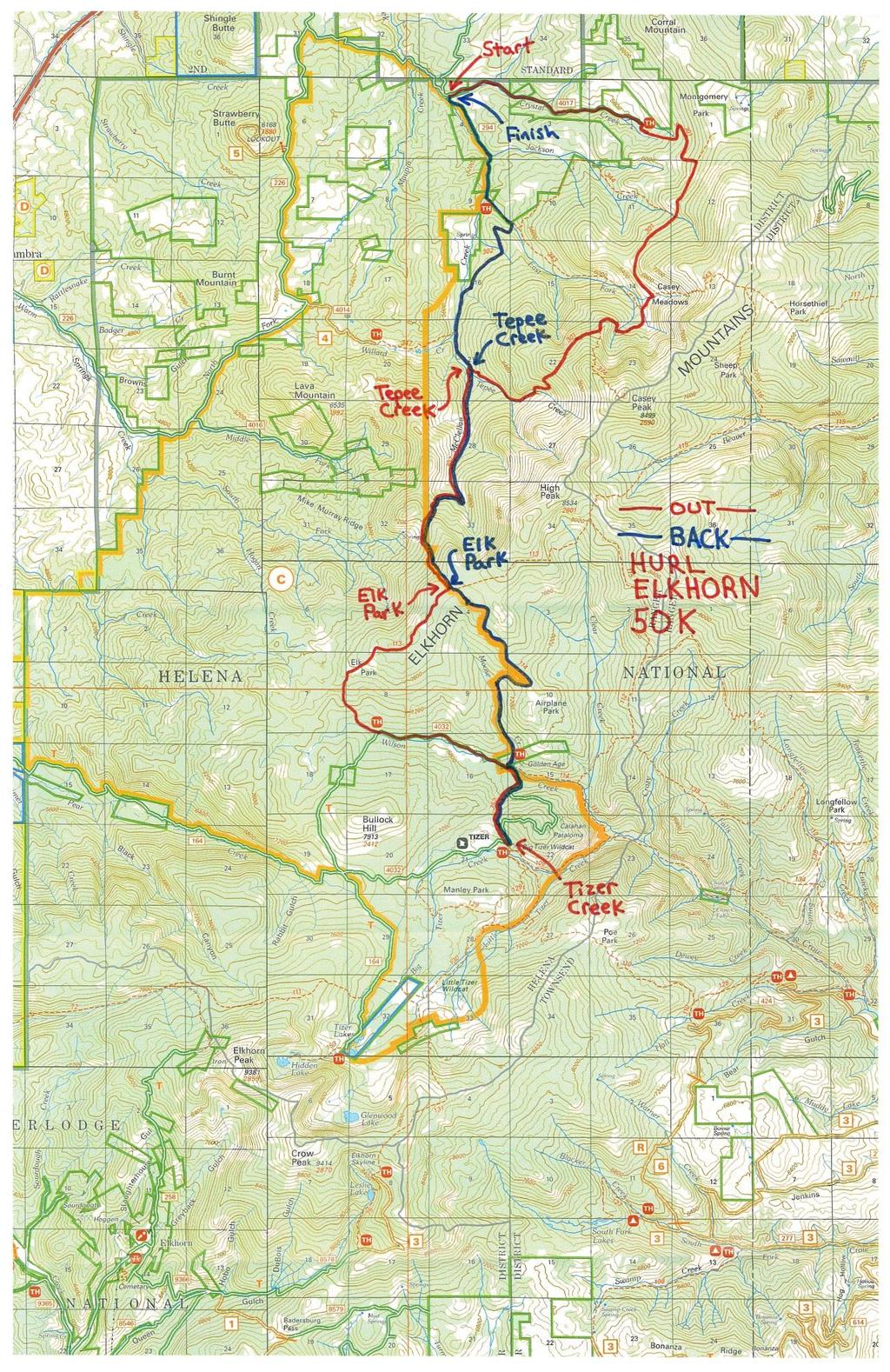
1 HURL ELKHORN 50K RUN AID STATIONS The race starts and finishes at Crystal Creek Campground, where primitive camping is available. The race starts at 7:00 am. The finish cut off time is 9:00 pm. No drop bags are allowed. The entire course runs through remote areas and crew access is difficult and generally not recommended. For runner s and volunteer s safety, there will be strict enforcement of a 1:30 pm cut off time at Elk Park Aid Station (1 st time through). AID STATION DISTANCE DROP BAGS SPECTATOR ACCESS CUT OFF TEPEE CREEK 10 MILES (16K) NO 2 MILES ON FOOT NONE ELK PARK 14 MILES (22.5K) NO NOT RECOMMENDED 1:30 pm* TIZER CREEK 19.5 MILES (31.5K) NO NOT RECOMMENDED NONE ELK PARK 24 MILES (39K) NO NOT RECOMMENDED NONE TEPEE CREEK 28 MILES (45K) NO 2 MILES ON FOOT NONE FINISH 32 MILES (51K) NO YES 9:00 PM *Runners missing the Elk Park Aid Station cut off will have to get back to the finish area on foot. Runners dropping out at Tepee Creek or Elk Park Aid Stations will have to get back to the finish area on foot. We will not be able to give rides to runners dropping out at Tizer Creek Aid Station until Aid Station volunteer s shift is done. You may be waiting a long time. Dropping out at Tizer Creek Aid Station is strongly discouraged. Be sure that aid station personnel record your presence at each aid station; otherwise, race management will assume that you did not complete the entire course. Also, make sure you leave aid stations in the correct direction. You are responsible for staying on course. Aid stations are staffed by volunteers and stocked with food, beverages, first aid supplies, etc. Most of our aid stations require volunteer access by backpack, horseback, or ATV to help you. Abuse of aid station volunteers will not be tolerated, and will result in disqualification. If you have a problem, please bring it to the attention of race management. We can t put on this race without volunteers. COURSE MARKINGS The course is marked with colored duct tape and occasional signs. Duct tape is attached to tree branches, tree trunks, rocks, etc. The trails tend to disappear in meadows. We have built rock cairns along the more difficult sections, which will be supplemented with colored duct tape for the race. Also in some meadows we will add wood stakes, painted or wrapped with colored duct tape, along the trail. The stakes do get knocked over by cattle and elk, so they may be lying on the ground.

2 The duct tape will be supplemented with reflective tape along the first couple of miles of trail and from Elk Park Aid Station, down trail 302 to the finish. Generally, in areas where the trail is not hard to follow and there are no intersections, course markings will not be frequent. When you see lots of marking, there is a trail intersection or a section that is tricky to follow pay attention. If you get to an intersection and there is no marking, you are probably off course. We will discuss tricky intersections at the course briefing. COURSE DESCRIPTION Note all distances and elevation gain and loss are based on tracings from quad maps, and therefore are approximate. These tracings indicate the course is approximately 32 miles (51K) long with approximately 7,400 feet of elevation gain and 7,400 feet of elevation loss. Start to Tepee Creek Aid Station (10 miles 16K) From Crystal Creek Campground run 2.75 miles (4.4K) up Forest Service Road Trail 301 leaves to your right at the end of the road. We will have someone at the end of the road to collect anything you don t want to carry for the next 29+ miles. We ll also have water here. This section of Trail 301 includes some abandoned roads with some switchbacks. You ll need to pay close attention to the course markings on this section of trail. Just past 4 miles (6.5K) you ll intersect a single track trail, turn right. This trail will take you across Jackson Creek to Casey Meadows. Watch for rock cairns and course markers when you are in meadows. Pay close attention to course markers in Casey Meadows. Stay on Trail 301. You must encounter two Forest Service Trail Signs in Casey Meadows, and must cross two creeks. Turn right and start uphill at the second sign which is just beyond the second creek crossing. This climb is very steep and rocky in places but the trail is easy to follow. Continue on Trail 301 past Trail 374. The trail eventually levels out and then turns downhill. After numerous downhill switchbacks you ll hit Tepee Creek. The trail turns right and follows the creek into Tepee Creek Aid Station (10 miles, 16K). Elevation gain = 2,862 feet. Elevation loss = 1,992 feet.


3 Left turn at second Forest Service Sign in Casey Meadows Right Turn at First Forest Service sign in Casey Meadows

 From Elk Park Aid Station, go right on Trail 113.")
4 Tepee Creek to Elk Park Aid Station (4 miles 6.5K) From Tepee Creek Aid Station turn uphill on Trail 302. The trail follows McClellan Creek for awhile but eventually climbs away from the creek, with numerous uphill switchbacks at the head of the McClellan Creek Basin. Following a brief downhill the trail continues climbing through more switchbacks over the top of the ridge, and a short downhill into Elk Park Aid Station (14 miles, 22.5K). Elevation gain = 2,360 feet. Elevation loss = 243 feet. Elk Park to Tizer Creek Aid Station (5.5 miles 9K) From Elk Park Aid Station, go right on Trail 113. The trail is fairly level for about a mile before eventually turning downhill and entering a series of meadows. The trail disappears in the meadows so pay close attention to the course markers. The trail is easy to follow in the sections of forest between the meadows. Below the last meadow, as the trail gets closer to Wilson Creek, it passes through some wet areas with tall grass making the trail hard to find. Elkhorn Peak view from Elk Park

 of the course and miss Tizer Creek Aid Station.")
5 Fortunately it should be well trampled down by the 50 mile runners. Once you get to Wilson Creek the trail follows the creek downstream (left) to Forest Service Road k runners must turn left on Road Road 4032 is a primitive, mostly double track road. The road is a generally a gradual downhill with Wilson Creek to your right. Nice running here. (NOTE: 50 mile runners turn right here, cross the creek and start a long uphill.don t blow it). Continue on Road 4032, past the trailhead for Moose Creek Trail 114. You are now on a short out and back section and if you start up Moose Creek now you will cut off 2.5 miles (4K) of the course and miss Tizer Creek Aid Station. We will assume you didn t complete the full course if you are not checked in or out of Tizer Creek Aid Station, and you won t be an official finisher. Turn left at intersection of Road 4032 Intersection of Road 4032 and Trail 114. Follow Road 4032 to the right.

6 Continue on Road 4032, past the next trailhead for Trail 114 which follows Wilson Creek downstream. Just past this trailhead Road 4032 crosses Wilson Creek and continues to angle to the right away from Wilson Creek (if you take Trail 114 downstream you will go way off course into a vast roadless area, and you may spend at least one night in the mountains). When Road 4032 veers sharply to the left, go straight ahead on Trail 352. Intersection of Road 4032 and Trail 352. Take Trail 352. Stay on Trail 352 uphill through the forest. Just over the crest of the climb the trail veers left through a meadow and disappears. Watch for course markers. You will be in meadows/heavy grass until you intersect Road 4032 again. Continue straight (downhill) on Road 4032 and very shortly you are at Tizer Creek Aid Station (19.5 miles, 31.5K). Elevation gain = 546 feet. Elevation loss = 1,455 feet. Tizer Creek to Elk Park Aid Station (5 miles 7.5K) From the Aid Station, head right (uphill) on primitive Forest Service Road While climbing watch for Trail 352 which angles off to the left. This intersection is very easy to miss. Trail 352 continues uphill thru a meadow without a visible trail. You ll enter the forest near the top of the short climb. The trail is very easy to follow through the forest, heads downhill, and intersects with Road 4032 again. Go left on Road Stay on the road across Wilson Creek and past the trailhead of Trail 114 following the creek

7 downstream (if you take Trail 114 downstream you will go way off course into a vast roadless area, and you will likely be spending at least one night in the mountains). Turn right on the second trailhead, Moose Creek Trail 114. Trail 114 starts out as a primitive road, there is a locked gate across the road to keep out vehicles. Just beyond the gate you pass a cabin on your right and a trailer on your left. If you don t see these within a few minutes of leaving Road 4032 you are not on going the right way. The primitive road eventually fades out to single track trail. You stay near Moose Creek, uphill, crossing Moose Creek. Once the trail leaves Moose Creek it passes through some meadows where the trail is faint so watch for the course markings. From Airplane Park the trail continues a long uphill through the forest. You will eventually cross a meadow (last opportunity to view Elkhorn Peak watch for rock cairns and course markers across the meadow) and reach the intersection with Trail 113. Turn left on Trail 113 and you ll be at Elk Park Aid Station in a minute (turn right on Trail 113 and you ll be heading towards a vast roadless area and may spend at least one night in the mountains). You have completed the last major climb when you enter Elk Park Aid Station (24 miles, 29K). Elevation gain = 1,430 feet. Elevation loss = 529 feet. Trail 352 angles to the left from Road 4032 just out of Tizer Creek Aid Station


8 Elkhorn Skyline from Spring Meadow Running on Trail 352

 Continue straight ahead and downhill from the Aid Station.")
9 Elk Park to Tepee Creek Aid Station (4 miles 6K) You ran this section the other direction earlier, and you ve got it made from here. Leave the Aid Station to the right on Trail 302 for a short uphill over the ridge, then downhill through the steep, rocky switchbacks to McClellan Creek. The trail continues downhill generally along McClellan Creek. Continue to the intersection with Trail 301 and the Tepee Creek Aid Station (28 miles, 45K). Elevation gain = 243 feet. Elevation loss = 2,360 feet. Tepee Creek to Finish (4 miles 6K) Continue straight ahead and downhill from the Aid Station. Continue downhill on Trail 302 past the intersection with Trail 347 and on to the intersection with Trail 343. Turn left (downhill) on Trail 343 and in approximately ¼ mile you reach the trailhead on Road 294. Turn right (downhill) on maintained road 294. The finish area is 1.5 miles (2.5K) down the road (32 miles, 51K). Elevation gain = 59 feet. Elevation loss = 902 feet. Congratulations, you have finished the HURL Elkhorn 50 K!


10 Finishing the HURL Elkhorn 50K!
11
Calaveras Big Trees State Park--South Grove Loop
 Copyright 1999 by Jeff Robinson. You are free to use and reproduce this description for personal, not-for-profit, and not-forbusiness use. Any reproduction other than for personal use, including businesses,
LAKE TAHOE peopleforbikes.org/e-bikes
 emtb ADVENTURE MAPS LAKE TAHOE peopleforbikes.org/e-bikes OVERVIEW Lake Tahoe is an iconic destination for mountain biking. With crystal blue waters surrounded by mountain peaks on all sides, the area
Pah Rah Mountain Range
 Pah Rah Mountain Range The Pah Rah Mountain Range is located east of the city of Sparks, and parallels Vista Boulevard. The mountain range originates at Interstate 80, and terminates at Pyramid Lake. Most
29th Running of the Ouachita Trail 50 Endurance Run April 13, 2019 Race Information
 29th Running of the Ouachita Trail 50 Endurance Run April 13, 2019 Race Information The Basics Location: Starting Time: Packets: Race Detail Maumelle Park, Little Rock, Arkansas, Pavilion # 8 (see map
High Uinta Wilderness
 High Uinta Wilderness July 5-7, 2010 Elevation: 10,000 11,000 Grayling, Brook, Cutthroat It was that time of year again to do my annual backpacking/fly fishing trip with my brothers. This year my brothers
Heathcote to Engadine via Audley
 Heathcote to Engadine via Audley 6 hrs 3 mins 5 km One way Hard track 4 635m Covering a large section of central Royal National Park, this walk goes through the heath and scrub along a well managed and
Trail and Driving Directions
 Trail and Driving Directions GETTING TO THE START: FROM CADILLAC: Follow M-55 west from US131 for 20.9 miles to the corner of M-37 and M-55 FROM THE INTERSECTION OF M-55 AND M-37: Head west on M-55 2.7
AWBOP Winter Events Risk Plan April 2016
 AWBOP Winter Events Risk Plan April 2016 1. EVENT FACILITIES 1.1 Traffic Approach Routes Consideration must be given to how traffic should approach the venue. Checks should be made to avoid possible conflicts
Navigating Briones: getting around an advanced orienteering course. Brown Course, October 2011.
 Navigating Briones: getting around an advanced orienteering course. Brown Course, October 2011. The trek to the start this year wasn t short and boy was it steep. But this should be treated as an opportunity
Trail Notes Local Mountain Bike Areas
 Trail Notes Local Mountain Bike Areas Campus Recreation 875 Perimeter Drive MS 1230 Moscow. Idaho 83844-1230 Ph: 208.885.6810 Rentals: 208.885.6170 Fax: 208.885.6879 uidaho.edu/outdoorprogram 1 Table of
Fish Lake Team Relay Course Information 2016
 Fish Lake Team Relay Course Information 2016 Fish Lake Team Relay Course Information 2016 The Fish Lake Team Relay begins at Fish Lake Lodge on the shores of beautiful Fish Lake located in Sevier County,
Gravel Bike Guide Haywood County
 Gravel Bike Guide Haywood County Haywood County is an ideal place for bicycling on gravel roads, because 37% or 129,994 acres of Haywood County is federal property, including portions of the Pisgah National
Detailed maps, and portaging and camping information follow.
 Overview of Bain route. The launch site is at Davidson Lake, just before the Manitoba/Ontario border. You can do a loop if you leave a vehicle at Tulabi Lake (at the canoe route parking lot). The road
2015 Brown County Epic Mountain Bike Festival General Information
 2015 Brown County Epic Mountain Bike Festival General Information Brown County Epic Registration Information * Changes in 2015 Epic Rides will take place on Saturday! Demos on Saturday and Sunday Registration
2016 North Country Trail Relay Updated Event Instructions Jan 2016
 Welcome to the 2016 North Country Trail Relay (NCTR). organized by Bev Chesebro and Doug Bostian The race is run on the North Country National Scenic Trail, which is a footpath that one day will stretch
Fish Lake Team Relay Course Information
 Fish Lake Team Relay Course Information Fish Lake Team Relay Course Information The Fish Lake Team Relay begins at Fish Lake Lodge on the shores of beautiful Fish Lake located in Sevier County, Utah. The
Gospel Hump Wilderness Date Late August 2012 Time Location Twin, Moores, Slate & Gospel Lakes Grangeville, ID
 Gospel Hump Wilderness Date Late August 2012 Time Location Twin, Moores, Slate & Gospel Lakes Grangeville, ID Weather Clear Fish Species Brook, Rainbow & Cutthroat Trout Size Range Small; a few 14-16 Rainbow
Welcome to the zwitty ultra guide to running the styr labs badwater 135 ultramarathon As fast as you possibly can!!!
 Welcome to the zwitty ultra guide to running the styr labs badwater 135 ultramarathon As fast as you possibly can!!! (OVERVIEW MAP) Section 8: lone pine to finish (122.4-134.2): this section is 11.8 miles.
MMT 100 Crew Instructions
 MMT 100 Crew Instructions Updated for the 2018 Event While crews are welcome at the MMT, they can cause congestion and related problems. Crews must comply with the provisions on this page. Race management
Explore the outdoors in Shelby County
 Explore the outdoors in Shelby County Oak Mountain Trail GPS: 33.283831-86.865238 Trail Location: Address: Oak Mountain State Park Trail 200 Terrace Drive Pelham, AL 35124 Type of Trail: Walking, Mountain
To Benefit the Wachusett Mountain Race Team!
 To Benefit the Wachusett Mountain Race Team! Handbook Outline: Race Overview & Events Schedule....3 Leg 1: 5-mile Run... 4 Leg 2: Scenic Bike Race.....5 Leg 3: Summit Climb......6 Leg 4: Ski Run...7 Application.....8
State Meet Saturday, November 5 th, 2016 Cave Creek Golf Course, Phoenix walkjogrun.net and search for N 19th Ave, Phoenix, AZ 85023
 Saturday, November 5 th, 2016 Cave Creek Golf Course, Phoenix walkjogrun.net and search for 15202 N 19th Ave, Phoenix, AZ 85023 Bus leaves at 6:00 AM Girls run at 8:55 PM but must report at 8:40 PM Boys
Marble: 9:10 am Creede: 11:57 am Today s Airtime: 2.8 hrs Total PIC Time: Total Logged Time:
 Sunday, September 10, 2017 Cobra flight #599, PIC #612, 1 landings Lilly Lake, Redstone Castle, Schoefield Pass, Maroon Bells, Maroon Lake, Half Moon Pass Marble: 9:10 am Creede: 11:57 am Today s Airtime:
Campbell Drive to Snapper Point
 Campbell Drive to Snapper Point 1 hr 45 mins 4.2 km One way Experienced only 135m This walk follows the Coast Track to Frazer Beach, along the Geebung and (overgrown) Grass Tree Tracks. From the northern
Wentworth Falls Conservation Hut Loop
 Wentworth Falls Conservation Hut Loop 3 hrs Hard track 6.7 km Circuit 4 341m This scenic walk from Wentworth Falls Station, winds along the Nature Trail to Conservation Hut, then drops into the magnificent
2016 Brown County Epic Mountain Bike Festival General Information
 2016 Brown County Epic Mountain Bike Festival General Information Brown County Epic Registration Information *2016 Epic Rides will take place on Saturday again this year. Event camping offered Thursday
May 19, 2018 RADIO OPERATIONS PLAN
 PACIFIC CREST TRAIL 50 MILE RUN May 19, 2018 RADIO OPERATIONS PLAN Run Website - http://www.pct50.com/ Race Director - John Martinez Communications Coordinator - Craig Williams W6CAW. 619-806-4146 craig@craigwilliams.com
Eligibility: You must have completed at least one 100 Mile TRAIL RUN or a qualifying 50 Miler (see website for 50 mile qualifying events).
.") Cruel Jewel 100 Mile Course Description The Cruel Jewel 100 is a 108 mile foot race deep with in the beautiful Chattahoochee National Forest of the North Georgia Mountains. It consists of 95 miles of trails,
Cruel Jewel 100 Mile Course Description The Cruel Jewel 100 is a 108 mile foot race deep with in the beautiful Chattahoochee National Forest of the North Georgia Mountains. It consists of 95 miles of trails,
Runner & Crew Handbook
 Never Summer 100K Runner & Crew Handbook Start : Gould Community Center, Gould, CO. Distance : 64.2 Miles with 13,000ft of vertical gain and 13,000ft of descent. Max Elevation : 11,852 Min Elevation :
SCHEDULE: Friday, October 20
 Welcome to the second annual Moran Constitutional Relay! We hope the information in this packet will answer many of the questions that you and other runners may have, but we've surely overlooked something,
Cactus to Cloud Trail Run RACE MANUAL
 Cactus to Cloud Trail Run RACE MANUAL Table of Contents Introduction 3 Organization Logistics 3 Shuttle 3 Lodging 4 Sponsors and Volunteers 4 Race Schedule 5 Packet Pickup 5 Race Day 5 Course Description
Patonga to Woy Woy. 5 hrs 45 mins 15.5 km One way. Hard track. 497m
 Patonga to Woy Woy 5 hrs 45 mins 15.5 km One way Hard track 4 497m This walk explores a variety of environments from the shore line and coastal cliffs near Patonga, to the dry, rocky and open ridge line.
THIS IS JUST YOU VS THE ELEMENTS
 THIS IS JUST YOU VS THE ELEMENTS COMPETITIOR IMPORTANT INFO ENTRY REQUIREMENTS IMPORTANT: Please note the following before you decide to enter the 22KM Expert or 13KM Intermediate Events: These are events
De Burgs Bridge to Thornleigh station
 De Burgs Bridge to Thornleigh station 3 hrs 45 mins 9.7 km One way Hard track 4 363m This walk follows a section of the Great North Walk, starting from De Burghs bridge. The walk winds north west, through
Banff-Jasper Relay Course Description March 17, 2005
 Banff-Jasper Relay Course Description March 17, 2005 The course description is general, although the distances are reasonably precise. The object is to give teams a sense of the conditions they will meet
Day 1 (Farley 7745, Bow Knot, Toxaway 8323)
") Date August 8 12, 2005 Time Location Sawtooths (Tin Cup Trailhead) Weather Scattered Clouds Fish Species Rainbow, Brook, Cutthroat Size Range Brook 6-11 Rainbow/Cutthroat 12-18 Fish Caught To many to count
Date August 8 12, 2005 Time Location Sawtooths (Tin Cup Trailhead) Weather Scattered Clouds Fish Species Rainbow, Brook, Cutthroat Size Range Brook 6-11 Rainbow/Cutthroat 12-18 Fish Caught To many to count
Volunteer Handbook. Galena Illinois May 16, 2015
 Volunteer Handbook Galena Illinois May 16, 2015 Welcome to the Galena Triathlon & Duathlon Volunteer Team! In an effort to make your volunteer experience an enjoyable one, we have created this handbook
Blackmare Lake Date Late August 2012 Time Location Blackmare Lake McCall, ID Weather Clear Fish Species Brook Trout
 Blackmare Lake Date Late August 2012 Time Location Blackmare Lake McCall, ID Weather Clear Fish Species Brook Trout Size Range Small Fish Caught Many Brook Trout Flies Used Elk Hair Caddis, Royal Wulff
Hornsby Blue Gum Walk
 Hornsby Blue Gum Walk 3 hrs Hard track 6.7 km Circuit 4 374m This delightful loop is one of the prettiest and most popular walks in the Hornsby area. Going from an environment of ferns and clear bushland
MAPLEDURHAM TEN RUNNERS INFORMATION Sunday 2nd December 2018
 MAPLEDURHAM TEN RUNNERS INFORMATION Sunday 2nd December 2018 Welcome to the Mapledurham Ten 2018. This is the first of three runs in our Winter Trail Series. The Mapledurham Ten course is mixed terrain
Engineering Report: Apache-Sitgreaves National Forests. Black Mesa Ranger District. Analysis of. National Forest System Roads (NFSRs) #s 504 & 169
 #s 504 & 169") Engineering Report: Apache-Sitgreaves National Forests Black Mesa Ranger District Analysis of National Forest System Roads (NFSRs) #s 504 & 169 for Motorized Mixed Use Designation Forest: Apache-Sitgreaves
Engineering Report: Apache-Sitgreaves National Forests Black Mesa Ranger District Analysis of National Forest System Roads (NFSRs) #s 504 & 169 for Motorized Mixed Use Designation Forest: Apache-Sitgreaves
Dead Horse Gap Loop track
 Dead Horse Gap Loop track 4 hrs 30 mins Hard track 9.8 km Circuit 144m 4 This walk starts with a ride up the Kosciuszko Express Chairlift. There is an opportunity to eat at Australia's highest restaurant,
Nebraska National Forests and Grasslands Bessey Ranger District Motorized Trail Width Project
 Nebraska National Forests and Grasslands Bessey Ranger District Motorized Trail Width Project Purpose and Need The purpose of this project is to improve motorized recreational opportunities by allowing
2015 G.O.A.T.z Trail Runs and G.O.A.T.z 50k
 2015 G.O.A.T.z Trail Runs and G.O.A.T.z 50k Sunday, October 25, 2015 8:00 a.m. Glenn Cunningham Lake - Omaha, NE Thank you for participating in the 4th Annual G.O.A.T.z Trail Runs and Omaha s ultramarathon,
Broaddus Loop. Lufkin & Angelina County Bicycle Route. Total Miles:
 Lufkin & Angelina County Bicycle Route Total Miles: 72.6 www.visitlufkin.com Route Directions: Segment Distance Direction of Total Distance Road Traveled (miles) Turn (miles) Start Lufkin High School
OPSF Participant Guide 2019
 OPSF Participant Guide 2019 TABLE OF CONTENTS Welcome Organization History Location Schedule of Events Friday, March 22, 2019 Saturday, March 23, 2019 Race Rules Parking Race Information Start Times Distances
Loch Ness Shores Club Site
 Loch Ness Shores Club Site Camping and Caravanning Falls of Foyers Route Summary A strenuous walk from Loch Ness Shores Club Site. The route climbs through forest to The Upper Foyers Waterfall and then
They re Shooting at Us!
 Event Type: Shooting Incident Date: August 23, 2018 Location: Miriam Fire, White Pass Ski Area 15 miles east of Packwood, Washington They re Shooting at Us! On August 23, the Miriam Fire is approximately
Event History: Kevin Tilton Steve Peterson Paul Young
 Event History: Northfield enters its fifth year as part of the Western Mass. Athletic Club (WMAC) snowshoe series. Northfield has served as a regional qualifier for the USSSA national championship and
2018 Neerim/Noojee 5M s Race Details
 2018 Neerim/Noojee 5M s Race Details We will meet at 8.00 am on Sunday 4th March 2018 at. Neerim South picnic area, corner of Main Neerim Road and Neerim East Road. Park in front of Neerim South Primary
Sid Pulsford Walk. 175m. 33m. 1 hr 45 mins 4.1 km One way. Hard track 118m. Gosford LGA
 Sid Pulsford Walk 1 hr 5 mins.1 km One way Hard track 118m Sid Pulsford Walk explores the ridge top of Kincumber Mountain, from Honeman's Rock to Green Point. The walk mostly follows wide management trails.
2017 Relay Team Handbook
 2017 Relay Team Handbook Race Date: April 23, 2017 (Updated 4/05/17) PRESENTED BY Welcome to the Mt. Si Relay 2017 This booklet contains important information for the 34th Annual Mt. Si Relay, April 23,
Course Maps Preliminary Version Awaiting final confirmation of construction on Rt. 100 June 19 Version
 Course Maps 2018 Preliminary Version Awaiting final confirmation of construction on Rt. 100 June 19 Version LEG #1- TRAIL MAP DESCRIPTION The runner lucky enough to start the race for their team immediately
Detailed Descriptions and Maps of Woodside s Nature Trails
 Detailed Descriptions and Maps of Woodside s Nature Trails Access Mill Road Trail Park along Anderson Mill road. Signs on West Pleasant Colony and Anderson Mill road clearly point to the beginning of the
Black Hills 100M/50M/30K Race Packet
 Black Hills 100M/50M/30K Race Packet SCHEDULE OF EVENTS What When Where Thursday, June 25, 2015 100M Packet Pickup 1:00-6:00 PM Sturgis City Park Stock Shelter Note: There will not be a formal pre-race
Coyote Buttes/The Waves
 Coyote Buttes/The Waves Ron Ross December 22, 2007 Coyote Buttes is located in the Paria Canyon-Vermilion Cliffs Wilderness just south of US 89 about halfway between Kanab, Utah and Page, Arizona. The
2018 Kathmandu Coast to Coast - Race Safety Briefing (Compulsory Section to attend)
") 2018 Kathmandu Coast to Coast - Race Safety Briefing (Compulsory Section to attend) These notes are current at time of email additional safety messages will be given at the pre-race safety briefings at
2018 Kathmandu Coast to Coast - Race Safety Briefing (Compulsory Section to attend) These notes are current at time of email additional safety messages will be given at the pre-race safety briefings at
Hunters Hill to Epping Road
 Hunters Hill to Epping Road 2 hrs 30 mins 5.5 km One way Moderate track 154m An enjoyable walk through lower sections of the Lane Cove National Park, this walk features plenty of mangroves next to the
Falls Lake Trail (A part of the NC Mountains-to-Sea Trail) East to West
 East to West") Falls Lake Trail (A part of the NC Mountains-to-Sea Trail) East to West Section 1 (Falls of the Neuse Rd to Raven Ridge Rd) 0.0 mi Parking area of the Tailrace Fishing Area, just below the dam, off Falls
Falls Lake Trail (A part of the NC Mountains-to-Sea Trail) East to West Section 1 (Falls of the Neuse Rd to Raven Ridge Rd) 0.0 mi Parking area of the Tailrace Fishing Area, just below the dam, off Falls
Rodopi mountain bike adventure (Bulgaria)
") Rodopi mountain bike adventure (Bulgaria) Real mountain bike adventure in the heart of the Rodopi mountains. This is a unique bike tour covering a great part of The Western and Middle parts of the mystic
Rodopi mountain bike adventure (Bulgaria) Real mountain bike adventure in the heart of the Rodopi mountains. This is a unique bike tour covering a great part of The Western and Middle parts of the mystic
Epping to Pennant Hills Station (via Lane Cove River)
") Epping to Pennant Hills Station (via Lane Cove River) 3 hrs 5 mins 8.4 km One way Hard track 249m This walk, from Epping to Pennant Hills Station, is a great way to see the upper Lane Cove River Valley.
Epping to Pennant Hills Station (via Lane Cove River) 3 hrs 5 mins 8.4 km One way Hard track 249m This walk, from Epping to Pennant Hills Station, is a great way to see the upper Lane Cove River Valley.
12/14/2015 Idaho Bald Mountain Sidecountry Published by Scott Savage, SAC
 Location: Place Christmas Eve, Bald Mountain Sidecountry State Idaho Date 12/14/2015 Time 1135 Summary 1 skier partially buried and injured due to striking trees Number: Caught 1 Fully Buried 0 Injured
Faulconbridge to Blaxland
 Faulconbridge to Blaxland 2 Days Experienced only 15.2 km One way 5 693m This two-day walk, or very solid one-day walk, takes you from station to station, through lush, scenic forest in the lower Blue
NORTH CAROLINA ACADEMIC DISCOVERY SCHEDULE Note: This schedule is subject to change. Registration, Inbriefs, Medications and Money
 NORTH CAROLINA ACADEMIC DISCOVERY SCHEDULE Note: This schedule is subject to change. Day 1: Students Arrive!!! Registration, Inbriefs, Medications and Money Group Games Move into cabin at SOAR Base Goals,
Walk NOC 03 Location: Llyn y Fan (the lake) and Fan Brycheinog (the mountain) off Trecastle Road
 and Fan Brycheinog (the mountain) off Trecastle Road") 8 Walk NOC 03 Location: Llyn y Fan (the lake) and Fan Brycheinog (the mountain) off Trecastle Road Directions: Distance (miles): Time (hours): Length of Walk: Turn right out of the castle, take first left
8 Walk NOC 03 Location: Llyn y Fan (the lake) and Fan Brycheinog (the mountain) off Trecastle Road Directions: Distance (miles): Time (hours): Length of Walk: Turn right out of the castle, take first left
Mountain Biking LA GRANDE OREGON. By Brian Sather & Mark Larson
 Mountain Biking LA GRANDE OREGON By Brian Sather & Mark Larson 2006 by Recreation Publishing. Summerville, Oregon. All rights reserved. No part of this book may be reproduced for sale. Only limited material
Castle Peak 100k. Participant Guide Edition. Saturday August 18, Presented by: CASTLE PEAK 100K RUNNERS GUIDE!1
 Castle Peak 100k Participant Guide 2018 Edition Saturday August 18, 2018 Presented by: CASTLE PEAK 100K RUNNERS GUIDE!1 Table of Contents Overview 4 Welcome 4 Organization 4 History 4 Schedule of Events
Marcella Creek. Elk & Deer Hunting Property With Springs and Creek in the Garnet Mountain Range. 160 acres for $195,000
 Granite County Elk & Deer Hunting Property With Springs and Creek in the Garnet Mountain Range 160 acres for $195,000 Bordering State Land and Nature Conservancy lands, this property is prime for elk and
CITY OF WEST LAKE HILLS. Forest View Neighborhood Traffic Calming Study
 CITY OF WEST LAKE HILLS 901 South Mopac Expressway Building V, Suite 220 Austin, Texas 78746 Texas P.E. Firm Registration No. F-929 Klotz Associates Final Report Submittal: March 20, 2015 Revised Final
Leg #1 (GUNLOCK AND LOADED) Miles
 Miles") Leg #1 (GUNLOCK AND LOADED)- 6.07 Miles Difficulty: Easy to Moderate This is a nice leg for those who like running downhill. It s a beautiful run down the Santa Clara River canyon to the point where the
Leg #1 (GUNLOCK AND LOADED)- 6.07 Miles Difficulty: Easy to Moderate This is a nice leg for those who like running downhill. It s a beautiful run down the Santa Clara River canyon to the point where the
Epping to Eastwood Station (via Lane Cove River)
") Epping to Eastwood Station (via Lane Cove River) hrs 45 mins 10.2 km One way Moderate track 189m Epping to Eastwood, via Lane Cove River, is the longer route through the bush between the stations. This
Epping to Eastwood Station (via Lane Cove River) hrs 45 mins 10.2 km One way Moderate track 189m Epping to Eastwood, via Lane Cove River, is the longer route through the bush between the stations. This
ELK VALLEY ULTRA RACER HANDBOOK PRESENTED BY STAG LEAP RUNNING CO. JULY 29, 2017 FERNIE, BC
 ELK VALLEY ULTRA RACER HANDBOOK JULY 29, 2017 FERNIE, BC PRESENTED BY STAG LEAP RUNNING CO. TABLE OF CONTENTS WELCOME PAGE 3 GETTING READY PAGES 3 4 o Accommodation Discounts o Can t Race? o Change to
LDWA SOUTH DOWNS MARATHON 13 th MAY 2018
 AHD ahead SDW South Downs Way BL/BR bear left/bear right TL/TR turn left/turn right X cross LEG 1 - EAST DEAN to WP1 NORTON GR 470019. Open 1030 to 1300. 9.7 miles. 1.1 From village hall TL and walk to
2017 Racer Manual Desert RATS mtb Classic
 2017 Racer Manual Desert RATS mtb Classic May 13, 2017 Fruita, CO Hello Racers and Crews! We can t wait to see all of you this May - hopefully with fresh legs and a powerful spirit, ready to start the
2:00pm-6:00pm - Packet Pickup at Summit Hut (Oro Valley) 7745 N. Oracle Rd.
 7745 N. Oracle Rd.") 50 Mile 50 Mile Relay 50K Participant Guide Oracle State Park January 27, 2018 Welcome: We would like to welcome all 50 Mile, 50 Mile Relay, and 50K runners and their crews to the inaugural AZT Oracle
50 Mile 50 Mile Relay 50K Participant Guide Oracle State Park January 27, 2018 Welcome: We would like to welcome all 50 Mile, 50 Mile Relay, and 50K runners and their crews to the inaugural AZT Oracle
Contents. Venue. Athlete's Check List Event Day. Event Schedule
 Runner's Guide Contents Venue Athlete's Check List Event Day Event Schedule Race Information Check-In Changes Race Bib Marathon Cut Off Times Bag Drop Aid Stations Toilets Safety on Course & Race Routes
Chapter 6 Performing Basic Vehicle Maneuvers
 Chapter 6 Performing Basic Vehicle Maneuvers Correct hand position To turn use Hand over hand steering Push and Pull steering Steering Turn Signals Use indicators/signals Indicators inform other drivers
Carrington Park to Leura Forest and pass loop
 Carrington Park to Leura Forest and pass loop 3 hrs Hard track 4.8 km Circuit 4 674m This walk is a fantastic way to see Leura Forest. The walk descends from Carrington Park, visiting Leura Forest and
Wattamolla to Big Marley Beach
 Wattamolla to Big Marley Beach 4 hrs 10.4 km Circuit Moderate track 4m This walk is an excellent loop which takes in both the coast and the heathy inland of Royal National Park. Nearly the whole walk has
 COASTAL CLIMB Uphill from the start on this Par 4. Tee shot from upper boxes should be right of bunker. For long hitters, going left of the bunker off the tee is high risk and reward to land near the green.
Description of Road Management Objectives, Existing Use, and Proposed Use:
 Engineering Report White River National Forest Eagle-Holy Cross Ranger District Analysis of Road # 600 Coffee Pot Road for Motorized Mixed Use Designation Page 1 of 12 Forest: White River District: Eagle-Holy
Wentworth Falls Station Loop (Undercliff Walk)
") Wentworth Falls Station Loop (Undercliff Walk) 4 hrs 3 mins Hard track 8.9 km Circuit 658m 4 This walk passes some stunning waterfalls and views into the Jamison Valley, following the cliff edges around
Wentworth Falls Station Loop (Undercliff Walk) 4 hrs 3 mins Hard track 8.9 km Circuit 658m 4 This walk passes some stunning waterfalls and views into the Jamison Valley, following the cliff edges around
2017 Big Woods Brown County Epic Mountain Bike Festival General Information
 2017 Big Woods Brown County Epic Mountain Bike Festival General Information Brown County Epic Registration Information Registration Includes: Free commemorative t-shirt Epic rides of up to 100 miles with
FINAL DETAILS - RACE 2 GOYT VALLEY
 FINAL DETAILS - RACE 2 GOYT VALLEY Thank you for entering the second event in the 2018 series, where we ve gone back to the usual format of the 3 hour event. We are pleased to see you at this first Peak
La Madre Wilderness Area
 La Madre Wilderness Area Rock Climbing Inventory Statistics: Area: Walls La Madre North 3 24 136 22 Kraft Mt./Gateway Canyon White Rock Springs Willow Springs East The Promised Land 18 4 3 3 12 23 11 24
Overview. Welcome. Frequently Asked Questions (FAQ s) Sponsors.. 42 Useful Information Links:
 Sponsors.. 42 Useful Information Links:") 1 Table of Contents: Overview 2 Race Location / Directions. 3 Registration / Qualification / Lottery / Refunds. 4-6 Solo Division Info. 7-8 Lodging 8-9 Schedule of Events. 10-11 Race Rules 12-14 Course
1 Table of Contents: Overview 2 Race Location / Directions. 3 Registration / Qualification / Lottery / Refunds. 4-6 Solo Division Info. 7-8 Lodging 8-9 Schedule of Events. 10-11 Race Rules 12-14 Course
Waterfall to Heathcote
 Waterfall to Heathcote 5 hrs Hard track 10.8 km One way 4 467m This walk explores the heart of Heathcote National Park, and is easily accessed with a train station at either end. Although relatively close
Bagshot Heath and Swinley Forest
 point your feet on a new path Bagshot Heath and Swinley Forest Distance: 13 km=8 miles Region: Berkshire, Surrey Author: Botafuego Refreshments: Forest Look Out, Bagshot easy walking Date written: 17-feb-2013
June 1, :00 A.M.
 Race Information Welcome to the North Fork Trail Race! This is the information you will need to be ready to run the race. Information on registration, the course, aid stations, area lodging and more can
RUNNER GUIDE. 4 Mile 20 Km 20 Mile 52 Km 52 Mile 100 Mile
 RUNNER GUIDE 4 Mile 20 Km 20 Mile 52 Km 52 Mile 100 Mile Salomon will be on site Saturday morning offering a shoe demo on their latest styles. Stop by the tent to check them out! RACE DAY SCHEDULE Please
LORNE VICTORIA SEPTEMBER 5 th Happy Fathers Day. RUNNERS PRE RACE INFORMATION PACK. Prepared by Race Director Brett Saxon
 LORNE VICTORIA SEPTEMBER 5 th 2015. Happy Fathers Day. RUNNERS PRE RACE INFORMATION PACK Prepared by Race Director Brett Saxon Welcome and thank you for supporting the newest trail running event on the
Queen Creek Canyon. Guidebooks The Rock Jocks Guide to Queens Creek Canyon by Marty Karabin Jr.
 is one of Arizona s best winter climbing destination. The area is about 1 1/2 hours east of hoenix and elevation is around 4000 feet. The rock is a thick formation of ash that was deposited between 15
chapter four Basics of high control
 chapter four Basics of high control F ew riders like spooky animals, and nobody wants sick ones. Spooky animals usually have a sensitive disposition and have experienced aggressive handlers. Sick animals
Bridger Wilderness Wind River Range Pinedale, WY Aug , miles / 25+ lakes Elevation: 8,000 11,000
 Bridger Wilderness Wind River Range Pinedale, WY Aug. 10-14, 2009 50 miles / 25+ lakes Elevation: 8,000 11,000 This is the trip that I have been anticipating for years. I consider the Wind Rivers to be
Superstition District. The Great Varsity Mayan Race. February 3 & 4, 2017
 Superstition District The Great Varsity Mayan Race February 3 & 4, 2017 Superstition District The Great Varsity Mayan Race February 3 & 4th, 2017 Table of Contents Who can attend?... 3 How to register?...
Pleasant Creek Trail Run 45K/30K/15K 2018 Participant Packet Do the Loop
 45K/30K/15K 2018 Participant Packet Do the Loop V2.0 note the start/finish of the event has changed to the park playground (just north of the original location) any changes to the participant packet as
COMPETITOR INFO PACK. Page 1
 2016 COMPETITOR INFO PACK Page 1 3 Page 2 75k 50k 25k Race start time 75km Competitors & Teams Race Start: 8am Briefing: 7:45am 50km Competitors Race Start: 9am Briefing: 8:45am 25km Competitors Race Start:
Updated Race Weekend Agenda:
 Greetings runners, There s a lot of VERY important information here, so please, please, please read this entire note. First off, we re looking forward to seeing all in Flagstaff! We hope you re looking
MOUNTAINS OF LAKE CREEK TBD LAKE CREEK RD. GORDON, TX
 MOUNTAINS OF LAKE CREEK TBD LAKE CREEK RD. GORDON, TX Palo Pinto Mountains Honey Creek Ridge Top Views Up to 195 Elevation Change Abundant Wildlife Mixed Hardwoods and Mesquite for Wildlife $52,500 - $343,000
3/8/2016 Oregon Wallowa Mountains Published by Michael Hatch (Wallowa Avalanche Center) and Scott Savage (on behalf of USFS National Avalanche Center)
 and Scott Savage (on behalf of USFS National Avalanche Center)") Location: Place Chief Joseph Peak, Wallowa Mountains State Oregon Date 3/8/2016 Time 1630 hrs Summary 1 skier partially buried and killed Number: Caught 1 Fully Buried 0 Injured 0 Killed 1 Avalanche Details:
Location: Place Chief Joseph Peak, Wallowa Mountains State Oregon Date 3/8/2016 Time 1630 hrs Summary 1 skier partially buried and killed Number: Caught 1 Fully Buried 0 Injured 0 Killed 1 Avalanche Details: