problems in Maintenance of Railway tracks in deserts And Possible solutions By Anurag sharma Former chief engineer Indian Railway
|
|
|
- Stanley Horton
- 5 years ago
- Views:
Transcription
1 problems in Maintenance of Railway tracks in deserts And Possible solutions By Anurag sharma Former chief engineer Indian Railway
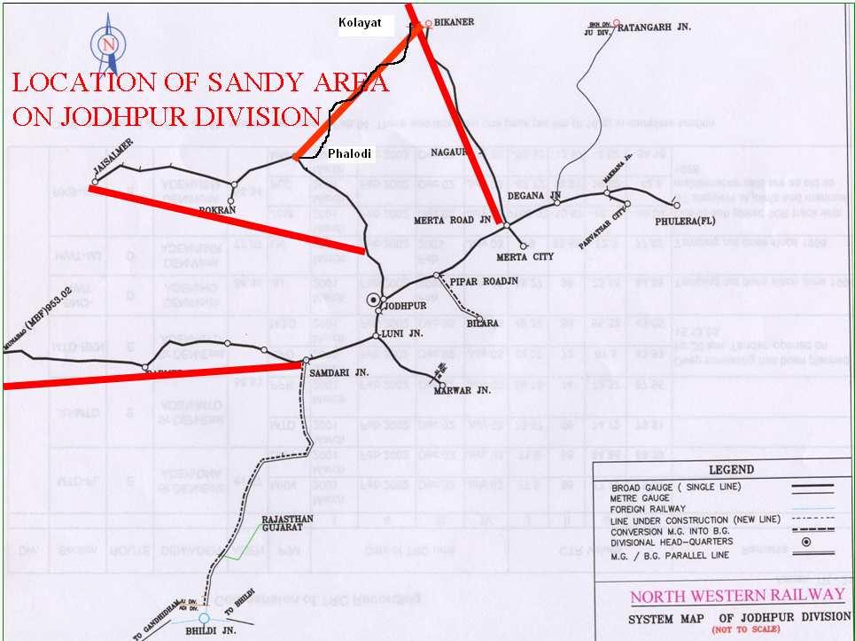
2 Tracks on Indian Railway North western Railways in India has large stretches of track in the Thar desert on its two divisions Division Total track km Track in desert % of total track Area of sandy soil Jodhpur division 1805 km 770 km 40% sq km Bikaner division 2241km 479 km 38% Sq km

3 Desert in India
4


5 LOCATION SHOWING SANDY TERRAIN JSM BME
6 TYPES OF SAND DUNES ON THAR DESERT
7 CLIMATIC CONDITIONS OF DESERT REGION Max. Wind velocity in Summer 70 to 80 kmph Average Mean Wind velocity 30 to 40 kmph Direction of Flow from south-west to north-east Annual Rainfall 100 to 300 mm But in particular area less than 100 mm or even no drop of rain in particular year. Temperature Season Ambient Sandy Soil at Surface Sandy Soil at 50 cm below Summer Max. up to 50 0 C 55 0 to 60 0 C 35 0 C Winter Min. up to 0 0
8 PROPERTY OF SAND (General) The properties of the Dunes Sand are as follows Non Cohesive. Sand Dunes without any type of vegetation. Highly errodable due to wind. (Even sand dunes of about 10 mtr. Height can shift their position in one Year) Very difficult to ply any vehicle except tractors and dozers. Get very hot during day and cold in night.
9 INDIA RAILWAYS SERVICES IN DESERT In India tracks of North western Railway zone tracks are located in the desert. These tracks were laid as per meter gauge standards to serve the local population but in the last 15 Years most of the lines have been converted into Broad gauge on which long distance trains and heavy good traffic also run. This has increased the importance of this network. In Bikaner division there are problems of sand drift while on Jodhpur division there is problem of cyclonic rains.
10 Track structure in desert region Gauge Rails Sleepers Ballast cushion Fittings BG 52 kg /m LWR Concrete sleepers in M=7 density 250 to 300 mm stone ballast cushion Elastic fastenings MG Mostly 90R or 75R and 60R in some case. It is mostly SWP CST-9 and ST sleepers with wooden sleepers on the joints 200 mm ballast cushion in most of the cases but sand cushion at some Conventional fittings places
11 TRACK MAINTENANCE IN DESERT REGION On Indian Railways regular maintenance is now being done with the help of track machines like tie tampers and ballast cleaning machines, etc. Due to mechanization hardships faced by Railway men in old days have minimized. But some of the problems persist. Indian Railways are making continuous efforts to improve the reliability and safety of services.
12 Special maintenance Problems in desert areas a). Extreme Temperature variations. b). Lack of Vegetation or poor vegetation. c). Scanty rainfall, active shortage of the water for the gang men and other staff in field. d). Corrosion due to salinity in the soil and water. e). Insufficient water-ways. f). Disruption due to sand storms. g). Water breaches due to obstructions in water ways. h) Disturbance of longitudinal levels due bulking of sand i) Deep screening and overhauling of the track is not effective.
13
14 Chemical composition of the sand in Rajasthan desert area
15 Engineering properties of the sand in the Thar desert.
16 Types of Sand dunes Old system type Average height of 20m to 40m They are stable New system type up to a height of 2m to 8m they are unstable and they move.
17 Types of dunes on the basis of shapes Barchans dunes: The barchans are formed from a relatively small sand supply under the influence of moderate wind of constant direction, thus stand apart from each other their convex side heading into the wind and the tips of their crescents tapering off to leeward.
18 Star dunes: A cluster of Barchans forms star dunes. These dunes are formed when wind blows from all directions. Unlike other types of dunes, which move in the direction of prevailing wind, star dunes remain stationary.

19 Transverse dunes: these are product of moderate, one way winds which move light sand, tumbling air eddies swirl heavier grains to the side which make ridges.

20 Longitudinal dunes: these dunes are formed when stronger one way wind moves, both fine and coarse, sand particles cutting the long troughs parallel with the path of the wind.

21 TYPES OF SAND DUNES

22 HALF MOON TYPE DUNE

23 HALF MOON TYPE DUNES

24 Compound Parabolic Dunes

25 TRANSVERSE DUNES LINEAR DUNES
26 Mechanism of sand storm As soon as the wind velocity is more than 16Kmph at one meter above ground sand starts lifting off the ground. Sand transportation is directly proportionate to cube of the velocity of the wind. During storms transportation of sand particle takes place as under: Rolling or surface creep- bigger sand particle(>0.25mm) move along the surface. Saltation- Medium size particles(0.15 to 0.25 mm) move constantly rise and fall and move by leaping. Suspension Fine sand Particles(< 0.15mm) are carried away to large distances.
27 DEPOSITION OF DRIFT SAND AROUND OBSTACLES Pattern deposition of drift sand varies depending upon the flexibility, permeability and location of the obstruction. Study of these patterns of deposition help in deciding the plantation strategy.
. Movement up to 2 mtr. Ht. Which is main cause of deposition of sand. Third layer of suspended particle above 2 4 mtr.")
28 Behavior of Sandy Soil/Sand Dunes during Sand Streams. (Contd.) During sandy storm sand flows with wind in three layers. First layer of heavy particle at lower height. Second layer of particle with dancing (sine wave). Movement up to 2 mtr. Ht. Which is main cause of deposition of sand. Third layer of suspended particle above 2 4 mtr. Ht.
29 Aerodynamic Characteristics of Sand Blowing Through porous obstruction Velocity of wind gets reduced due to porous barrier and upto 20 H line of length the effect of sand blowing is less. Through impervious obstructions If velocity of wind is restricted by dense barriers the wind flows in turbulent pattern and eddy currents forms which results in deposition of sand near barriers.
30
31
32
33
34
35
36
37 Problems due to sandy storms and cyclonic rains Blockade of railway track due to sand deposits Loss of elasticity of track due to chocking of ballast bed Drainage problem Corrosion of rails and fittings Loss of visibility due to new sand dunes Excessive wear of rails Breaches even in scanty rain fall Signal failures
38 Problems faced during sand storms and cyclonic rains Please look at some panoramic views of track after sand storms and breaches

39 WATER BREACHES IN RKB-JSM SECTION ON 20/8/2006
 Effects on Yard Drainage")
40 OTHER PROBLEMS FACED (Contd.) Effects on Yard Drainage etc.

41 OTHER PROBLEMS FACED (Contd.) Effect on Visibility
42 OTHER PROBLEMS FACED (Contd.) Effect on Visibility
43 Day to day remedial actions Some of the photographs showing common remedial measures in the desert region are shown in coming slides
 (Contd.) Deputation of patrolman")
44 ROUTINE MAINTENANCE WORKING (During Sand Storms) (Contd.) Deputation of patrolman
 (Contd.")
45 ROUTINE MAINTENANCE WORKING (During Sand Storms) (Contd.) Removal of sand by Tractors
46 ROUTINE MAINTENANCE WORKING (During Sand Storms) (Contd.) Flange way clearing by manual labour
47 ROUTINE MAINTENANCE WORKING (During Sand Storms) (Contd.) Removal of Sand by manual labour
48 Precautions to be taken in case of a new line Route the railway line around the high dunes Select the formation on embankment if the prevailing wind blows along the line and in the cutting if the wind blows across the line In high velocity wind and sandy region select the height of the bank equal to the average height of the dunes
49 Precautions to be taken in case of a new line contd. Increase the width of right of way for protective measures. At least 100 m land width on either side of the track should be available. Carry out erection of shields protecting the vegetation on the strip adjacent to formation. Adopt mild slopes not steeper than 1 in 200. Make effective catch water drains to minimize the damage during the cyclonic rains.
50 Problems in the existing lines and possible solutions Erosion of the bank during summer months Where railway alignment is across the direction of wind this damage is more. Provide shield of local bushes in slopes and edge of embankment Erosion of the bank during monsoon Make cross drains one per rail length as a pre-monsoon work. Dress up slopes away from the centre of track.. At the moth of the drain provide dry bushes and do paving of the drain.
51 Problems and possible solutions contd. Loose sand from the top of the bankroll down to the formation due to strong wind or due to vibration Widen the cuttings. If possible ease out the slopes and turf the slopes with the arid bushes.
52 Problems and possible solutions contd. During monsoon sandy cuttings or soft moorum move along with water Widen the cutting ease out the slopes Pave the side drains with stones. In such areas patrolling is necessary
53 Problems and possible solutions contd. Huge sand deposits take place on the embankment and in the cuttings leveling of adjoining sand dunes Spraying of oil on the sand dunes to stabilize them Dress up ridges by the side of track Provide air passage between the sleepers and the rails Cut sand channels in the direction of wind on both side of track. Trapezoidal channels with wooden sleepers on the mouth of the channel increase their effectiveness.
54
55 Solutions to drift sand contd. Provide impervious wall 6 above and 18 below ground on the dune on the wind ward side
56 Solutions to drift sand contd. Remove obstacles from the leeward side. There should be no obstacles higher than the formation level. Plantation/ protection of small plants in railway land Dig trenches parallel to railway line on the boundary on wind ward side
57 Solutions to drift sand contd. Stabilize the sand dunes by plantation with the help of a special bricks which retain moisture even up to one year.
58 Solutions to drift sand contd. Protect the sand surface with a cover spray with emulsion of petroleum resins. Roughening of the surface for slowing down the wind velocity. For this barriers are placed 10m from the track. Also trenches are dug on the leeward side to collect the sand. Av series of banks and trenches helps in controlling the problem for the longer duration.
59 Solutions to drift sand contd. Provide shelter belt of trees shrubs and grass in rows. Tallest tree should be in the centre
60 REMEDIAL MEASURES (Contd.) Local Shrub of 1 ft. height Local Shrub of 1 ft. height 15 M 10 M Local green plant of 2 ft. height Track Plantation in pyramid shape
61 Changes during the gauge conversion After the gauge conversion of the sections in the desert area, problems have come down due to following improvements done during gauge conversion project: 1. Use of stone ballast in place of sand and kankar ballast. 2. Easing out of the slopes. 3. Heavier track structure i.e. rail and sleepers.
62 Other Happenings in the Area After the commissioning of Rajasthan canal problem sand blowing have come down substantially in its command area Plantation in the area in general has reduced the problem.
63 Magnitude of the Problem at present Due to the above reasons and other measures taken by the Indian railways, no of accidents and blockades to the traffic have been reduced to 1 or two in year and the blockade of traffic on an average of 7 days in a year. Due to vigilant management most of the accident causing occasions get converted into cancellation of trains or loss of punctuality cases.
64 Conclusions After the strengthening of the track structure during gauge conversion problems have been reduced Easing out of grades has also helped Use of stone ballast in place of sand ballast track levels are better maintained Plantation has helped in sand dune stabilization
Chapter 15. The Work of Wind and Deserts
 Chapter 15 The Work of Wind and Deserts Introduction What is desertification? Desertification is the expansion of deserts into formerly productive lands. These expansions destroy croplands and rangelands.
Chapter 10, Part 1. Scales of Motion. Examples of Wind at Different Scales. Small Scale Winds
 Chapter 10, Part 1 Small Scale Winds Scales of Motion Wirls or eddies exist at all length scales in the atmosphere. Microscale (2m) Mesoscale (20km) Synoptic scale (2000km) Examples of Wind at Different
MT - GEOGRAPHY - (73) - SEMI PRELIM - II : PAPER - 6
 - SEMI PRELIM - II : PAPER - 6") 208 00 MT MT - GEOGRAPHY - (7) - SEMI PRELIM - II : PAPER - 6 Time : 2 Hours (Model Answer Paper) Max. Marks : 0 A.. Fill in the blank choosing the correct alternative : (a) The Barren Island is the only
208 00 MT MT - GEOGRAPHY - (7) - SEMI PRELIM - II : PAPER - 6 Time : 2 Hours (Model Answer Paper) Max. Marks : 0 A.. Fill in the blank choosing the correct alternative : (a) The Barren Island is the only
* Appalachian Mountains -the mountain range in the Eastern U.S. which terminates in north-central Alabama
 MR. SAND TEACHER'S MANUAL INTRODUCTION: Although Mr. Sand is a cartoon presentation that is attractive to children (of all ages), the material is technically accurate and quite significant to our understanding
WIND AND SNOW FENCES
 Fencing Order No. 307.230-1 Revised December 2015 WIND AND SNOW FENCES Whereas many fence designs are constructed for livestock and wildlife control or crop protection, these designs are to modify either
Ocean Motion Notes. Chapter 13 & 14
 Ocean Motion Notes Chapter 13 & 14 What is a Wave? Wave: movement of energy through a body of water How are Waves Caused? Caused mostly by wind Wind blowing on the water transmits energy to the water Size
Chesil Beach, Dorset UK High energy, shingle coastline. Brighton Beach, Sussex UK Pebble beach
 Beaches: Depositional landform Extends from the highest high tide to the lowest low tide. Very important temporary store in coastal system. Accretion: sediment returning to the visible portion of a beach
Chapter 10 Lecture Outline. The Restless Oceans
 Chapter 10 Lecture Outline The Restless Oceans Focus Question 10.1 How does the Coriolis effect influence ocean currents? The Ocean s Surface Circulation Ocean currents Masses of water that flow from one
Avalanche Problem Essentials Wind Slabs. Development
 1 Avalanche Problem Essentials Wind Slabs This document is part of Decision Making in Avalanche Terrain: a fieldbook for winter backcountry users by Pascal Haegeli, Roger Atkins and Karl Klassen and provides
Dry Hydrants. The installation of a non-pressurized pipe system into local water sources provides a ready means of supplying water to fire engines.
 Dry Hydrants What is a Dry Hydrant? A dry hydrant is a non-pressurized pipe system permanently installed in existing lakes, ponds and streams that provides a suction supply of water to a fire department
CHAPTER 4: BEST MANAGEMENT PRACTICES FOR EROSION AND SEDIMENTATION CONTROL
 Figure 4.4m. Type III Floating Turbidity Barrier Source: American Boom and Barrier Corporation and Virginia Department of Transportation (DOT) Standard Sheets 71 4.4.6 Floating Turbidity Barrier Definition
WIND: A GLOBAL GEOLOGIC PROCESS
 WIND: A GLOBAL GEOLOGIC PROCESS Smith and Pun, Chapter 20 WHY WIND BLOWS Wind is motion in the atmosphere. Movement of gas molecules in the atmosphere occurs for the same reason that motion occurs within
Figure 1. Schematic illustration of the major environments on Mustang Island.
 STOP #1: PACKERY CHANNEL BEACH TO BAY We will start this field guide near the north jetty of Packery Channel and hike across the island to Corpus Christi Bay (fig. 1). The island emerges from the Gulf
Australian Coastal Councils Conference
 Australian Coastal Councils Conference Kiama March 2019 Where Has My Beach Gone? (and what can I do about it?) Dr Andrew McCowan Water Technology Where Has My Beach Gone? Where Has My Beach Gone? Where
West Africa Desertification in West Africa
 Non-fiction: West Africa Desertification in West Africa West Africa Desertification in West Africa In Arabic, Sahel means shore, or coast. The Sahel is the place where the waves of the ocean crash onto
Local Winds. Please read Ahrens Chapter 10
 Local Winds Please read Ahrens Chapter 10 Scales of Motion Microscale: meters Turbulent eddies Formed by mechanical disturbance or convection Lifetimes of minutes Mesoscale: km s to 100 s of km s Local
Chapter. The Dynamic Ocean
 Chapter The Dynamic Ocean An ocean current is the mass of ocean water that flows from one place to another. 16.1 The Composition of Seawater Surface Circulation Surface Currents Surface currents are movements
ADA Training Standard Plans
 ADA Training Standard Plans SCREEN READABLE VERSION IS IN THE MAKING AND WILL BE MADE AVAILABLE SOON 2018 MnDOT 2 Standard Plans 2017 Overview Overview PROWAG and Curb Ramp Basics Curb Ramp Types ADA Curb
2. The phrases on the left in the following box occur in the text. Match each of them with a phrase on the right. (i) an endless stretch of sand
 an endless stretch of sand") A desert is generally without water and vegetation. A green patch with fresh water and green trees in the middle of a vast desert is a beautiful sight. A desert may be too hot or too cold. THOSE of us
A desert is generally without water and vegetation. A green patch with fresh water and green trees in the middle of a vast desert is a beautiful sight. A desert may be too hot or too cold. THOSE of us
Local Winds & Microclimates. Unit 2- Module 1
 Local Winds & Microclimates Unit 2- Module 1 Objectives Overview of local winds (sea & land breezes, valley winds) Overview of microclimates (valley, urban, woodland) Local Winds Local Winds Local winds
Components of a Barrage
 Components of a Barrage Definition The only difference between a weir and a barrage is of gates, that is the flow in barrage is regulated by gates and that in weirs, by its crest height. Barrages are costlier
(Revised February,2005) CULVERTS, BRIDGES, AND FORDS
 CULVERTS, BRIDGES, AND FORDS") GUIDE TO STREAM CROSSINGS (Revised February,2005) CULVERTS, BRIDGES, AND FORDS Culverts, bridges, and fords are all methods used to cross-streams. Culverts are the most common stream crossing structure.
GUIDE TO STREAM CROSSINGS (Revised February,2005) CULVERTS, BRIDGES, AND FORDS Culverts, bridges, and fords are all methods used to cross-streams. Culverts are the most common stream crossing structure.
Earth s oceans covers 71 % _ of the planet s surface. In reality, Earth s ocean waters are all. interconnected as part of a single large global ocean.
 Ocean Motion Met 101: Introduction to the World's Oceans Produced by The COMET Program Geography: Name Pd. Earth s oceans covers 71 % _ of the planet s surface. In reality, Earth s ocean waters are all
Geometric designs for Safe Highways. Dr. Manoj M. Asst. Professor Department of Civil Engineering IIT Delhi
 Geometric designs for Safe Highways Dr. Manoj M. Asst. Professor Department of Civil Engineering IIT Delhi WORKSHOP-CUM-TRAINING PROGRAMME ON ROAD SAFETY 17th 21st September 2018 Outline Introduction Cross
DESIGN CODE. Enterprise West Harlow London Road North Design Code 21
 DESIGN CODE Enterprise West Essex @ Harlow London Road North Design Code 21 4 MAXIMUM BUILDING HEIGHTS 4.1 Table 4A sets out maximum building height standards for each character area within the LDO boundary.
Design Overview. Section 4 Standard Plans for Design. Pedestrian Access Routes. Pedestrian Access Routes. Overview. Cross Slope
 Design Overview Section 4 Standard Plans for Design Fall, 2017 Ann Johnson, PE Services Brady Rutman, SRF Consulting Group Overview Design Basics Recommendations: The Zone System Driveway Crossings Pedestrian
Road Safety Audit training course. Motorways - safety issues of the motorway design
 Road Safety Audit training course Motorways - safety issues of the motorway design Jesper Mertner, Road safety auditor, COWI A/S 1 ROAD SAFETY AUDITING COURSE Content 1. Safety 2. Cross sections 3. Horizontal
Concepts & Phenomena
 Concepts & Phenomena in coastal and port sedimentation R. Kamalian Ports and Maritime Organization of Iran and PIANC-Iran 7 9 December 2015 What is the problem? Many harbours have sedimentation problems
RESILIENT CITIES 2011
 RESILIENT CITIES 2011 EKO ATLANTIC CITY PROJECT AS A CLIMATE CHANGE ADAPTATION STRATEGY Presentation by Prince Adesegun Oniru ( Honourable Commissioner, Lagos State Ministry of Waterfront Infrastructure
OPERATION. Estimated kerf width compensation. HPR260 Manual Gas Instruction Manual 4-9
 Estimated kerf width compensation The widths in the chart below are for reference. Differences between installations and material composition may cause the specific user results to vary from those shown
NOT TO SCALE PUBLIC WORKS STANDARD DETAILS CURB DETAILS DATE: MARCH 2013 FILE NAME: CURB.DWG
 NOT TO SCALE PUBLIC WORKS STANDARD DETAILS CURB DETAILS DATE: MARCH 2013 FILE NAME: CURB.DWG NOT TO SCALE PUBLIC WORKS STANDARD DETAILS SIDEWALK RAMPS DATE: MARCH 2013 FILE NAME: SIDEWALK RAMPS.DWG NOT
Wind: Small-scale and Local Systems
 Wind: Small-scale and Local Systems Scales of Atmospheric Motion Atmospheric motions/phenomena occur on many diverse spatial and temporal scales. Weather forecasters tend to focus on Mesoscale and synoptic
Culvert Design for Low and High Gradient Streams in the Midwest. Dale Higgins, Hydrologist Chequamegon-Nicolet National Forest
 Culvert Design for Low and High Gradient Streams in the Midwest Dale Higgins, Hydrologist Chequamegon-Nicolet National Forest Overview Culvert Design Considerations Hydraulic Terms Culvert Impacts Low
3-13 UFC - GENERAL PROVISIONS AND GEOMETRIC DESIGN FOR ROADS, STREETS, WALKS, AND OPEN
 maintenance, and erosion. Stability is required to maintain the integrity of the pavement structure, and a slope stability analysis should be conducted for cuts and fills greater than 15 feet. For lower
Define the key terms: - Abrasion - Attrition - Hydraulic action - Solution. Y11 Coasts
 Define the key terms: - Abrasion - Attrition - Hydraulic action - Solution Abrasion caused by waves picking up material which is forced against the cliff face wearing it away Attrition where stones and
LAB: WHERE S THE BEACH
 Name: LAB: WHERE S THE BEACH Introduction When you build a sandcastle on the beach, you don't expect it to last forever. You spread out your towel to sunbathe, but you know you can't stay in the same spot
Installation. Striping Kit for 42in and 50in Mowers Model No Installation Instructions. Removing the Mower Deck.
 Striping Kit for 42in and 50in Mowers Model No. 120 7905 Form No. 3368-794 Rev B Installation Instructions Installation Loose Parts Use the chart below to verify that all parts have been shipped. Procedure
DEAD-ENDCHANNELFLUSHINGINHARBORS
 DEAD-ENDCHANNELFLUSHNGNHARBORS PURPOSE: The purpose of this technical note is to present some design con- siderations which benefit dead-end channel flushing. Some of these factors can also be used to
TRAFFIC CONTROL DEVICES MANUAL FOR WORK ZONES
 TRAFFIC CONTROL DEVICES MANUAL FOR WORK ZONES APPLICATION Delineation devices are used to warn and alert motorists of hazards created by work activities in or near the travelled way and to guide and direct
Exploring Wind Energy
 2013-2014 Exploring Wind Energy Student Guide SECONDARY Introduction to Wind What is Wind? Wind is simply air in motion. It is produced by the uneven heating of the Earth s surface by energy from the sun.
Lecture Outlines PowerPoint. Chapter 15 Earth Science, 12e Tarbuck/Lutgens
 Lecture Outlines PowerPoint Chapter 15 Earth Science, 12e Tarbuck/Lutgens 2009 Pearson Prentice Hall This work is protected by United States copyright laws and is provided solely for the use of instructors
Track Use and Maintenance Guidelines
 Precision Sports Surfaces, Inc. 3325 Lobban Place, Charlottesville, VA 22903 (434) 971-9628 Fax (434) 971-1131 www.precisionsurfaces.com Track Use and Maintenance Guidelines The following information is
JAP Additional Information Sheet
 JAP Additional Information Sheet Block 15: Purpose and Need The USACE purpose of the project is to provide a safe and reliable whitewater park for the recreational public in a city park, which will provide
COASTAL MANAGEMENT AND PROTECTION METHODS! 1
 COASTAL MANAGEMENT AND PROTECTION METHODS! 1 Strategy What it does Cons Pros Examples SOFT ENGINEERING: The use of ecological principles and practices to reduce erosion and achieve the stabilization and
The Sea Geography Notes JC-Learn. JC-Learn. Geography Notes The Sea. 1 P a g e
 JC-Learn Geography Notes The Sea 1 P a g e The Sea *Here, you can choose to study the chapter on glaciation or the one on the sea, or even both, because whenever these topics come up in the Junior Cert
Monitoring excavation in the highway
 This unit covers the requirements that you must meet when monitoring excavation work in the highway. You must ensure that you act in accordance with all current specifications and procedures and that you
Coastal Change and Conflict
 Coastal Change and Conflict Outline of the Topic Contrasting Coasts why do all coasts not look the same? Geology of the coast the impact rock structure has on the coastline Waves Constructive and destructive
Exemplar for Internal Assessment Resource Geography Level 3. Resource title: The Coastal Environment Kaikoura
 Exemplar for internal assessment resource Geography 3.5A for Achievement Standard 91430 Exemplar for Internal Assessment Resource Geography Level 3 Resource title: The Coastal Environment Kaikoura This
Spilt body Flange ball valve. TC-205MFF-PN1640 User Manual English Version. Document No: TC-205MFF-PN1640.Ur-manual. Date: 2007/04/2617. Version: 1.
 Spilt body Flange ball valve TC-205MFF-PN1640 Series PED Category I,II TC-205MFF-PN1640 User Manual English Version Use for company in Europe who will place the product on the market, please amend which
Chapter - Oceans and Coasts
 Chapter - Oceans and Coasts Discussion: What do oceans contribute to the environment of Earth? How do Earth s major systems relate to the oceans? Oceans and Coasts Oceans are important - Thermal regulation
(HIGHWAY GEOMETRIC DESIGN -1)
") LECTURE HOUR-19 TE-1(10CV56) UNIT-3 (HIGHWAY GEOMETRIC DESIGN -1) Width of carriage way: Width of the carriage way or the width of the pavement depends on the width of the traffic lane and number of lanes.
LECTURE HOUR-19 TE-1(10CV56) UNIT-3 (HIGHWAY GEOMETRIC DESIGN -1) Width of carriage way: Width of the carriage way or the width of the pavement depends on the width of the traffic lane and number of lanes.
Chapter 22, Section 1 - Ocean Currents. Section Objectives
 Chapter 22, Section 1 - Ocean Currents Section Objectives Intro Surface Currents Factors Affecting Ocean Currents Global Wind Belts (you should draw and label a diagram of the global wind belts) The Coriolis
CHAPTER 181 MAN-MADE BEACHES MORE THAN 20 YEARS ON FRANCK ROUCH 1 BERNARD BELLESSORT Z
 CHAPTER 181 MAN-MADE BEACHES MORE THAN 20 YEARS ON FRANCK ROUCH 1 BERNARD BELLESSORT Z Abstract This article is an overview of the behaviour of artificial beaches based more particularly on three important
Basis of Structural Design
 Basis of Structural Design Course 10 Actions on structures: Wind loads Other loads Course notes are available for download at http://www.ct.upt.ro/users/aurelstratan/ Wind loading: normative references
There are many different kinds of beaches which are generally characterized by the dominance of waves, tides, rivers and currents, and in particular
 Fig. 11-11, p. 253 There are many different kinds of beaches which are generally characterized by the dominance of waves, tides, rivers and currents, and in particular differ by the amount of energy, which
Chapter # 08 Waves. [WAVES] Chapter # 08
![Chapter # 08 Waves. [WAVES] Chapter # 08](/thumbs/94/121079132.jpg "Chapter # 08 Waves. [WAVES] Chapter # 08") Chapter # 08 Waves Q2) Write short answers of the following questions. i) What is the difference between progressive and stationary waves? Answer: Progressive Waves 1 Progressive waves are the result of
Chapter # 08 Waves Q2) Write short answers of the following questions. i) What is the difference between progressive and stationary waves? Answer: Progressive Waves 1 Progressive waves are the result of
Footpath design. A guide to creating footpaths that are safe, comfortable, and easy to use
 Footpath design A guide to creating footpaths that are safe, comfortable, and easy to use November 2013 Contents Introduction / 1 Zoning system / 2 Width / 4 Height / 5 Surface / 5 Footpath elements /
REVETMENTS. Purposes and Operational Constraints. Purposes Erosion control o o. Revetment Design 4/5/2016. CE A676 Coastal Engineering
 REVETMENTS Ijsseldam, the Netherlands Orson P. Smith, PE, Ph.D. Instructor Purposes and Operational Constraints Purposes Erosion control o o Embankment Toe protection for a seawall, retaining wall or other
Managing Density For Asphalt Pavement
 Managing Density For Asphalt Pavement 1 Density vs. Pavement Performance 2 Cost of Compaction Least expensive part of the process Compaction adds little to the cost of a ton of asphalt Importance of Compaction
Lecture 10 : Sewer Appurtenances
 1 P age Module 8 : Sewer Appurtenances Lecture 10 : Sewer Appurtenances 2 P age The structures, which are constructed at suitable intervals along the sewerage system to help its efficient operation and
Notepack 41. Aim: What factors determine the climate of a certain area? Do Now: What is the difference between weather and climate?
 Notepack 41 Aim: What factors determine the climate of a certain area? Do Now: What is the difference between weather and climate? WEATHER VS. CLIMATE Weather atmospheric conditions at a certain location
Monsoon. Arabic word mausim means season. Loose definition: a wind/precipitation pattern that shifts seasonally
 Monsoon Arabic word mausim means season Loose definition: a wind/precipitation pattern that shifts seasonally Classical criteria (Ramage 1971) Prevailing wind shifts 120 o between Jan & July Average frequency
LOAD CHARTS RT540E 85% STABILITY ON OUTRIGGERS 75% STABILITY ON RUBBER
 LOAD CHARTS RT540E 85% STABILITY ON OUTRIGGERS 75% STABILITY ON RUBBER SERIAL NUMBER 1 2 TABLE OF CONTENTS GENERAL NOTES... 4 WT. REDUCTIONS / LINE PULLS & REEVING INFO / HOIST PERFORMANCE. 5 LIFTING AREA
UNDERWATER BRIDGE INSPECTION REPORT STRUCTURE NO CSAH NO. 7 OVER THE SNAKE RIVER DISTRICT 1 - PINE COUNTY
 UNDERWATER BRIDGE INSPECTION REPORT STRUCTURE NO. 58506 CSAH NO. 7 OVER THE SNAKE RIVER DISTRICT 1 - PINE COUNTY PREPARED FOR THE MINNESOTA DEPARTMENT OF TRANSPORTATION BY COLLINS ENGINEERS, INC. JOB NO.
LOAD CHARTS RT890E METRIC DIN / ISO / 75%
 LOAD CHARTS RT89E METRIC DIN / ISO / 75% 232729 SERIAL NUMBER RT89E - S/N 232729 1 RT89E - S/N 232729 2 TABLE OF CONTENTS GENERAL NOTES...4 WEIGHT REDUCTIONS / LINE PULLS & REEVING INFO / RIGGING CHART
Beach Profiles: Monitoring Sea Level Rise. Student Activity Sheet. Name Date Class
 Beach Profiles: Monitoring Sea Level Rise Student Activity Sheet Name Date Class A shoreline is the area where the water and land meet. This is where we find beach: areas where sediments (sand or other
GO THERE THE TAKLAMAKAN DESERT BECAUSE YOU
 NAME 1 GO THERE THE TAKLAMAKAN DESERT BECAUSE YOU CAN T GET OUT!! Using the coordinates. 37 44 N, 81 49 E, FLY TO the Desert, the largest desert of its kind in the world (based on percentage area covered
APPENDIX C VEGETATED EMERGENCY SPILLWAY. VERSION 1.0 March 1, 2011
 APPENDIX C VEGETATED EMERGENCY SPILLWAY VERSION 1.0 March 1, 2011 [NOTE: Could use a better photo more clearly showing the emergency spillway in the context of the dam.] SECTION C-1: DESCRIPTION OF PRACTICE
SURFACE CURRENTS AND TIDES
 NAME SURFACE CURRENTS AND TIDES I. Origin of surface currents Surface currents arise due to the interaction of the prevailing wis a the ocean surface. Hence the surface wi pattern (Figure 1) plays a key
Chapter 19: Vibrations And Waves
 Lecture Outline Chapter 19: Vibrations And Waves This lecture will help you understand: Vibrations of a Pendulum Wave Description Wave Speed Transverse Waves Longitudinal Waves Wave Interference Standing
Big Spring Creek Habitat Enhancement and Fishery Management Plans
 Big Spring Creek Habitat Enhancement and Fishery Management Plans November 5, 2012 Big Spring Events and Activities Center Newville, PA Charlie McGarrell Regional Habitat Biologist Pennsylvania Fish and
WIND SPEED LENGTH OF TIME WIND BLOWS (Duration) DISTANCE OVER WHICH IT BLOWS (Fetch)
 DISTANCE OVER WHICH IT BLOWS (Fetch)") WAVES Up and down movement of ocean surface Transportation of energy across the water over vast distances If not stopped by anything, waves can travel entire oceans Size and speed depend upon: WIND SPEED
WAVES Up and down movement of ocean surface Transportation of energy across the water over vast distances If not stopped by anything, waves can travel entire oceans Size and speed depend upon: WIND SPEED
Paper Report for Possible Road Locations within Saint Edwards State Park
 Paper Report for Possible Road Locations within Saint Edwards State Park Jedediah Bryce Troy Lane Kim Littke Douglas Marconi Project #1 Submitted to: Professor Peter Schiess on April 4 th, 2009 ESRM 468
1 Shoreline Erosion and Deposition
 CHAPTER 12 1 Shoreline Erosion and Deposition SECTION Agents of Erosion and Deposition BEFORE YOU READ After you read this section, you should be able to answer these questions: What is a shoreline? How
Longshore sediment transport
 and Orson P. Smith, PE, Ph.D., Professor Emeritus Longshore transport Waves breaking at an angle to shore Sediment under breakers lifted by saltation Drops back to sea bed a little down drift Swash (runup)
YOUR ISTRC SYSTEM REPORT CITY FREDERICKSBURG Mr. Bill Hanna
 YOUR ISTRC SYSTEM REPORT TM CITY OF FREDERICKSBURG January 13, 2017 Park Area Topdressing Sand Lab ID: 16120031 Presented To: Mr. Bill Hanna 11372 Strang Line Road Lenexa, KS 66215 Phone: 800-362-8873
The Composition of Seawater
 The Composition of Seawater Salinity Salinity is the total amount of solid material dissolved in water. Most of the salt in seawater is sodium chloride, common table salt. Element Percent Element Percent
Earthen Embankments. turning into larger, more costly repairs. The following. The State Dam Safety Program has inspection
 TOPIC: COMMON PROBLEMS FOR SMALL DAMS WITH CONCRETE CHANNEL SPILLWAYS The State Dam Safety Program has inspection requirements for state regulated dams. A dam, like any man-made structure, will change
Profiles Of Survey Maps 45/D7 and 45/D10
 Profiles Of Survey Maps 45/D7 and 45/D10 PROFILE OF SURVEY MAP 45 D/7DESCRIPTION of the Area covered by Survey Sheet No. 45 D/7 (Gujarat and Rajasthan) District : Banas Kantha and Sirohi Location: Latitude
Getting a. Bridge Built
 Getting a Bridge Built The progress of the Black River bridge construction was recorded by two I men, the clerk and the bookkeeper of the project. Their photographs of the work have left a wonderful record
ABSTRACT INTRODUCTION
 Sengupta, M. and Dalwani, R. (Editors). 2008 Proceedings of Taal2007: The 12 th World Lake Conference: 1022-1027 Water Erosion Control Using the Fetch Calculator. Applications for Constructed Wetlands
12/14/2015 Idaho Bald Mountain Sidecountry Published by Scott Savage, SAC
 Location: Place Christmas Eve, Bald Mountain Sidecountry State Idaho Date 12/14/2015 Time 1135 Summary 1 skier partially buried and injured due to striking trees Number: Caught 1 Fully Buried 0 Injured
FINAL REPORT. Yonkers Creek Migration Barrier Removal Project Wonderstump Road Del Norte County. Submitted By:
 FINAL REPORT Yonkers Creek Migration Barrier Removal Project Wonderstump Road Del Norte County Submitted By: Del Norte County Community Development Department Yonkers Creek Migration Barrier Removal Project
ASPHALT PAVING LEVEL 1
 ASPHALT PAVING LEVEL 1 Module 3: Yield Calculations: Tack Coat and Mix Spread Rate FDOT Course Module 3 1 Welcome the students to the third module in this course that covers tack coat and mix spread rates,
CHAPTER 16. Waves and Sound
 CHAPTER 16 Waves and Sound Objectives: After completion of this module, you should be able to: Demonstrate your understanding of transverse and longitudinal waves. Define, relate and apply the concepts
2 nd Term Final. Revision Sheet. Students Name: Grade: 10 A/B. Subject: Physics. Teacher Signature
 2 nd Term Final Revision Sheet Students Name: Grade: 10 A/B Subject: Physics Teacher Signature 1 NAME: GRADE: 10 MULTIPLE CHOICES PHYSICS WORKSHEET In the space provided, write the letter of the term or
Improving Road Safety for North Eastern State Roads of India A Case Study
 Improving Road Safety for North Eastern State Roads of India A Case Study North Eastern States Portugal Debasis Chakrabarty, Transportation Engineer Key figures of North Eastern States Road Project Total
STUDY GUIDE. Physical Features. The Land. Chapter 23, Section 1. Landforms. Rivers. Natural Resources. Terms to Know DRAWING FROM EXPERIENCE
 For use with textbook pages 569 574. The Land Terms to Know subcontinent A landmass that is large and distinct but joined to a continent (page 569) alluvial plain An area of fertile soil deposited by river
CROSS-SHORE SEDIMENT PROCESSES
 The University of the West Indies Organization of American States PROFESSIONAL DEVELOPMENT PROGRAMME: COASTAL INFRASTRUCTURE DESIGN, CONSTRUCTION AND MAINTENANCE A COURSE IN COASTAL DEFENSE SYSTEMS I CHAPTER
ADA on Construction. Guidance for Section C Plan Preparers
 ADA on Construction Guidance for Section C Plan Preparers Some impacts cannot be avoided and those impacts apply to residents, businesses, motorists, and pedestrians alike. However, good planning can minimize
Installation and Training Manual
 AirForce1 Tower Kit Installation and Training Manual FuturEnergy Limited Ettington Park Business Centre Stratford upon Avon CV37 8BT +44 (0)1789 451070 Table of Contents Safety Notes... 3 Parts Supplied
PHYSICAL GEOGRAPHY. By Brett Lucas
 PHYSICAL GEOGRAPHY By Brett Lucas ATMOSPHERIC PRESSURE AND WIND Atmospheric Pressure and Wind Atmospheric Processes The Nature of Wind General Circulation of the Atmosphere Modifications of General Circulation
A D V A N T A G E, HAR-TRU.
 ADVANTAGE, UPDATING A CLASSIC. Unique subsurface irrigation systems are another technological innovation that makes a classic HAR-TRU surface even more popular. Built with a controlled water reservoir
Proposed Sand/ Moram Mining Project at Gata No.- 17/1 Village- Sehjana, Tehsil & District- Hamirpur, U.P. RISK ASSESMENT RISK ASSESSMENT
 RISK ASSESSMENT Mining and allied activities are associated with several potential hazards to both the employees and the public at large. A worker in a mine should be able to work under conditions, which
2016 FACT SHEET ENGINEERING STREET OPERATIONS. Engineering Street Operations net 2016 budget is $5,199,900 WHAT IS ENGINEERING STREET OPERATIONS?
 WHAT IS STREET OPERATIONS? This section maintains approximately 570 km of major, collector and residential roads throughout Saanich. Some of the major programs include road surface treatments (pothole
Accommodating Pedestrians in the Work Zone
 Accommodating Pedestrians in the Work Zone Guidance for Section C Plan Preparers Some impacts cannot be avoided and those impacts apply to residents, businesses, motorists, and pedestrians alike. However,
Low Gradient Velocity Control Short Term Steep Gradient Channel Lining Medium-Long Term Outlet Control Soil Treatment Permanent [1]
![Low Gradient Velocity Control Short Term Steep Gradient Channel Lining Medium-Long Term Outlet Control Soil Treatment Permanent [1]](/thumbs/80/80811988.jpg "Low Gradient Velocity Control Short Term Steep Gradient Channel Lining Medium-Long Term Outlet Control Soil Treatment Permanent [1]") Check Dams DRAINAGE CONTROL TECHNIQUE Low Gradient Velocity Control Short Term Steep Gradient Channel Lining Medium-Long Term Outlet Control Soil Treatment Permanent [1] [1] Though not generally considered
Check Dams DRAINAGE CONTROL TECHNIQUE Low Gradient Velocity Control Short Term Steep Gradient Channel Lining Medium-Long Term Outlet Control Soil Treatment Permanent [1] [1] Though not generally considered
Beach profile surveys and morphological change, Otago Harbour entrance to Karitane May 2014 to June 2015
 Beach profile surveys and morphological change, Otago Harbour entrance to Karitane May 2014 to June 2015 Prepared for Port Otago Ltd Martin Single September 2015 Shore Processes and Management Ltd Contact
Risk Assessment RA-1. Risk Assesment
 Risk Assessment The complete mining operation will be carried out under the management control and direction of a qualified mine manager The DGMS have been regularly issuing standing orders, model standing
Non-required Fences Update
 Non-required Fences Update Quality of Life & Environment Committee January 11, 2016 Presented by the Department of Sustainable Development and Construction Purpose Follow up on the May 26, 2015, August