Beach Access Easement through Kahu`Aina Plantation to Waipake Beach and Kepuhi Point
|
|
|
- Jodie Carr
- 5 years ago
- Views:
Transcription


1 Beach Access Easement through Kahu`Aina Plantation to Waipake Beach and Kepuhi Point

2

3 Kahu`Aina Subdivision Plan

4 Multiple Family Estates


5 2002 LUC CD
6 2002 Land Use Commission Conservation District Boundary Determination

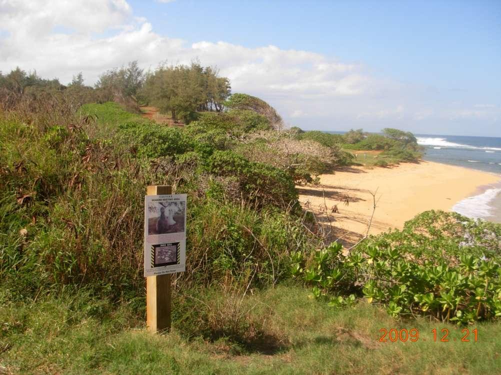
7 File Plan Map 2458 New Revised Map

8 Kahu`aina Plantation Subdivision File Plan 2458

9 New Revised Map from March 18, 2013
10 2002 CDBD Waipake LCA 6582
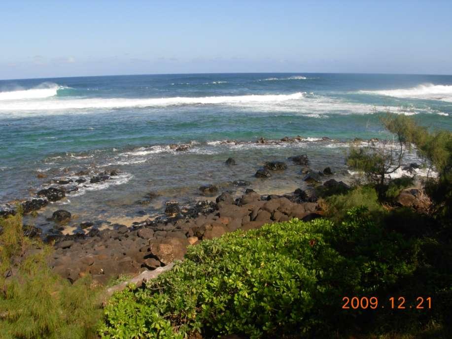
11 Conservation District Boundary has been changed 2002 SHORELINE 2013 CD is now in ocean instead of 300 mauka.

12

13 How can new CD Boundary be in the ocean?

14 How many 100 Width Housesites will be visible from Waipake Beach? Notes: 1. Flood zone information is based on the Flood Insurance Rate Map for Kaua`i County, Hawaii, panel 80 of 356, revised September 6, 2005/ Flood Zone VE Elevation 25 & 26 *For lots that have homesites visible from beach area, the Planning Department will review the individual homesite plans at building permit. For homesites visible from the beach, the building permit is limited to one story above existing grade and a maximum visible width of 100 feet from the beach area. 2. Water service is not available from the Department of Water, County of Kauai.

15 KA HAE HAWAII. Buke I, Helu 37, Aoao 145. Novemaba 12, KAI NUI MA KAA, KOOLAU, KAUAI E ka Hae Hawaii : ALOHA OE:--I ka Ponono, eia ka la 18 o Okakoba nei, hora 8 paha o ke kakahiaka o ua la la, oia ka la nalu ma Kaa, Koolau. Eia na mea i pilikia, 4 waa, 4 hale, 3 loi kalo. No Mohulu na waa i nahaha, a me na hale elua. Hookahi o Puko hale; hookahi o Kamokuliu i nahaha i keia kai. Mai Waipake ke a Lepeuli keia pilikia. Hookahi no wili nalu, o ka pau loa no ia o keia mau hale a me na waa, a me na loi kalo. J. W. G. KAIA Hanalei. Oka. 18, 1856.

16 Remains of St. Stephen s Roman Catholic Church, Moloa`a Built by Father Maudet in 1854 Destroyed by several tsumami in the 1860 s that carried car-sized boulders ¾ mile inland..

17 Moloa`a April 6, 1946


18 1946 Tsunami 33 wave at shore 38 wave 750 mauka 33 Wave at Pakala Point, Waipake Flood Zone VE 26 & 26

19 SOEST EROSION
20 REGULAR MEETING MINUTES BOARD OF WATER SUPPLY Thursday, June 17, 2010 include New Lot Owners agree to: Maximum Density on New Lots limited to 70 dwelling units and one guest house on each New Lot.


21 How much water does Kahu`aina really need? 9 Wells, 15 meters. What impact will all this water withdrawal have on the fresh-water dependent reef resources, especially limu? What impact will all this water withdrawal have on neighboring community wells in an area with no county water service?

22 Proposed Easement Gated

23

24

25

26 1913 Waipake Stream Bridge Ko`olau Road

27 1913 Waipake Bridge

28 17 wide 17 Wide, 100 year old One Lane Bridge Waipake Stream

29 One Lane Bridge after Blind Curve on Ko`olau Road, currently rated at 90 cars per day. This bridge is less than ½ mile from Kahu`aina Entrance. Kahu`aina could generate 300 additional vehicle trips over this bridge per day.

30 Broken Bridge Piling Waipake Stream Bridge Ko`olau Road, Kauai

31

32 Bridge Piling Broken > 5 years Caution Cone in Stream
33 National Bridge Inventory Data 1992 Inspection Status: Posted for load [P] Average daily traffic: 90 [as of 1981] Deck condition: Fair [5 out of 9] Superstructure condition: Poor [4 out of 9] Substructure condition: Fair [5 out of 9] Channel protection: Bank protection is in need of minor repairs. River control devices and embankment protection have a little minor damage. Banks and/or channel have minor amounts of drift. [7] Scour condition: Scour calculation/evaluation has not been made. [6] Operating rating: 16.1 tons [14.6 metric tons] Inventory rating: 9.9 tons [9.0 metric tons] Evaluation: Structurally deficient [1] Sufficiency rating: 24.1 Estimated cost of work: $7,000
![National Bridge Inventory Data Status: 2000 Inspection Posted for load [P] Average daily traffic: 90 [as of 1981] Deck condition: Fair [5 out of 9] Superstructure condition: Poor [4 out of 9]](/docs-images/94/120325069/images/34-0.jpg "Substructure condition: Fair [5 out of 9] Channel protection: Bank protection is in need of minor repairs. River control devices and embankment protection have a little minor damage.")
34 National Bridge Inventory Data Status: 2000 Inspection Posted for load [P] Average daily traffic: 90 [as of 1981] Deck condition: Fair [5 out of 9] Superstructure condition: Poor [4 out of 9] Substructure condition: Fair [5 out of 9] Channel protection: Bank protection is in need of minor repairs. River control devices and embankment protection have a little minor damage. Banks and/or channel have minor amounts of drift. [7] Scour condition: Bridge foundations determined to be stable for the assessed or calculated scour condition. [8] Operating rating: 16.2 tons [14.7 metric tons] Inventory rating: 10.0 tons [9.1 metric tons] Evaluation: Structurally deficient [1] Sufficiency rating: 24.2 Recommended work: Replacement of bridge or other structure because of substandard load carrying capacity or substantial bridge roadway geometry. [31] Estimated cost of work: $390,000
![Status: National Bridge Inventory Data 2010 Inspection Posted for load [P] Average daily traffic: 90 [as of 1981] Deck condition: Fair [5 out of 9] Superstructure condition: Poor [4 out of 9]](/docs-images/94/120325069/images/35-0.jpg "Substructure condition: Fair [5 out of 9] Channel protection: Bank is beginning to slump. River control devices and embankment protection have widespread minor damage.")
35 Status: National Bridge Inventory Data 2010 Inspection Posted for load [P] Average daily traffic: 90 [as of 1981] Deck condition: Fair [5 out of 9] Superstructure condition: Poor [4 out of 9] Substructure condition: Fair [5 out of 9] Channel protection: Bank is beginning to slump. River control devices and embankment protection have widespread minor damage. There is minor stream bed movement evident. Debris is restricting the channel slightly. [6] Scour condition: Bridge foundations determined to be stable for the assessed or calculated scour condition. [8] Operating rating: 12.1 tons [11.0 metric tons] Inventory rating: 9.2 tons [8.4 metric tons] Evaluation: Structurally deficient [1] Sufficiency rating: 27.3 Recommended work: Replacement of bridge or other structure because of substandard load carrying capacity or substantial bridge roadway geometry. [31] Estimated cost of work: $390,000

36 2013

37


38 Easement to Waipake Beach


39


40 Kepuhi
41

42
43

44 Best Beach Access Easement at Waipake Family Friendly Culturally and Environmentally Sensitive Historically Appropriate
45

46 Proposed Kahu`aina 10 Wide, 1 Mile long Easement ends at cliff

47 Ka`aka`aniu Reef Native Hawaiians' traditional and customary access and gathering rights must be honored. Waipake Lepeuli Ka`aka`aniu At Moloa`a, on the island of Kauai, a crude kind of culture of limu kohu is carried on. The natives have cleared out all of the other seaweed from the reef so that the Asparagopsis does not suffer from competition and is here much finer and more luxuriant than at any other place. Botanical Gazette, Volume 65. By Charles Reid Barnes, 1918

48 Traditional and Cultural Users & OHA Community Involvement Agency Coordination Communication
UNDERWATER BRIDGE INSPECTION REPORT STRUCTURE NO CSAH NO. 7 OVER THE SNAKE RIVER DISTRICT 1 - PINE COUNTY
 UNDERWATER BRIDGE INSPECTION REPORT STRUCTURE NO. 58506 CSAH NO. 7 OVER THE SNAKE RIVER DISTRICT 1 - PINE COUNTY PREPARED FOR THE MINNESOTA DEPARTMENT OF TRANSPORTATION BY COLLINS ENGINEERS, INC. JOB NO.
UNDERWATER BRIDGE INSPECTION REPORT DISTRICT 4 - OTTER TAIL COUNTY
 UNDERWATER BRIDGE INSPECTION REPORT STRUCTURE NO. L0885 TWP NO. 970 OVER THE OTTER TAIL RIVER DISTRICT 4 - OTTER TAIL COUNTY PREPARED FOR THE MINNESOTA DEPARTMENT OF TRANSPORTATION BY COLLINS ENGINEERS,
UNDERWATER BRIDGE INSPECTION REPORT DISTRICT 8 - LAC QUI PARLE COUNTY
 UNDERWATER BRIDGE INSPECTION REPORT STRUCTURE NO. 6391 CSAH NO. 33 OVER THE MINNESOTA RIVER DISTRICT 8 - LAC QUI PARLE COUNTY OCTOBER 22, 2012 PREPARED FOR THE MINNESOTA DEPARTMENT OF TRANSPORTATION BY
UNDERWATER BRIDGE INSPECTION REPORT DISTRICT 4 - OTTER TAIL COUNTY
 UNDERWATER BRIDGE INSPECTION REPORT STRUCTURE NO. L0885 TWP NO. 970 OVER THE OTTER TAIL RIVER DISTRICT 4 - OTTER TAIL COUNTY PREPARED FOR THE MINNESOTA DEPARTMENT OF TRANSPORTATION BY COLLINS ENGINEERS,
Information for File # SEW
 Information for File #2014-02744-SEW Applicant: Minnesota Department of Transportation (MnDOT), District 3; c/o Mr. Robert Nibbe Corps Contact: Sarah Wingert, U.S. Army Corps of Engineers, 180 5 th Street
UNDERWATER BRIDGE INSPECTION REPORT STRUCTURE NO OVER THE STRAIGHT RIVER DISTRICT 6 - RICE COUNTY
 UNDERWATER BRIDGE INSPECTION REPORT STRUCTURE NO. 66513 14 th STREET (MSAS NO. 103) OVER THE STRAIGHT RIVER DISTRICT 6 - RICE COUNTY PREPARED FOR THE MINNESOTA DEPARTMENT OF TRANSPORTATION BY COLLINS ENGINEERS,
UNDERWATER BRIDGE INSPECTION REPORT STRUCTURE NO CSAH 133 OVER A DITCH ST. LOUIS COUNTY
 UNDERWATER BRIDGE INSPECTION REPORT STRUCTURE NO. 7780 CSAH 133 OVER A DITCH ST. LOUIS COUNTY SEPTEMBER 27, 2012 PREPARED FOR THE MINNESOTA DEPARTMENT OF TRANSPORTATION BY COLLINS ENGINEERS, INC. JOB NO.
UNDERWATER BRIDGE INSPECTION REPORT METRO DISTRICT - ANOKA COUNTY
 UNDERWATER BRIDGE INSPECTION REPORT STRUCTURE NO. 02545 CR NO. 116 OVER THE RUM RIVER METRO DISTRICT - ANOKA COUNTY SEPTEMBER 9, 2012 PREPARED FOR THE MINNESOTA DEPARTMENT OF TRANSPORTATION BY COLLINS
UNDERWATER BRIDGE INSPECTION REPORT DISTRICT 8 - LAC QUI PARLE COUNTY
 UNDERWATER BRIDGE INSPECTION REPORT STRUCTURE NO. 6391 CSAH NO. 33 OVER THE MINNESOTA RIVER DISTRICT 8 - LAC QUI PARLE COUNTY PREPARED FOR THE MINNESOTA DEPARTMENT OF TRANSPORTATION BY COLLINS ENGINEERS,
UNDERWATER BRIDGE INSPECTION REPORT STRUCTURE NO CSAH NO. 101 OVER THE MINNESOTA RIVER DISTRICT 8 - REDWOOD COUNTY
 UNDERWATER BRIDGE INSPECTION REPORT STRUCTURE NO. 7149 CSAH NO. 101 OVER THE MINNESOTA RIVER DISTRICT 8 - REDWOOD COUNTY PREPARED FOR THE MINNESOTA DEPARTMENT OF TRANSPORTATION BY COLLINS ENGINEERS, INC.
UNDERWATER BRIDGE INSPECTION REPORT STRUCTURE NO CSAH NO. 9 OVER THE BLUE EARTH RIVER DISTRICT 7 - BLUE EARTH COUNTY
 UNDERWATER BRIDGE INSPECTION REPORT STRUCTURE NO. 07542 CSAH NO. 9 OVER THE BLUE EARTH RIVER DISTRICT 7 - BLUE EARTH COUNTY PREPARED FOR THE MINNESOTA DEPARTMENT OF TRANSPORTATION BY COLLINS ENGINEERS,
UNDERWATER BRIDGE INSPECTION REPORT DISTRICT 1 PINE COUNTY
 UNDERWATER BRIDGE INSPECTION REPORT STRUCTURE NO. 58551 CSAH NO. 41 OVER THE KETTLE RIVER DISTRICT 1 PINE COUNTY JULY 28, 2012 PREPARED FOR THE MINNESOTA DEPARTMENT OF TRANSPORTATION BY COLLINS ENGINEERS,
UNDERWATER BRIDGE INSPECTION REPORT STRUCTURE NO MSAS 123 (2 ND AVE. SW) OVER THE CANNON RIVER CITY OF FARIBAULT, RICE COUNTY
 OVER THE CANNON RIVER CITY OF FARIBAULT, RICE COUNTY") UNDERWATER BRIDGE INSPECTION REPORT STRUCTURE NO. 66546 MSAS 123 (2 ND AVE. SW) OVER THE CANNON RIVER CITY OF FARIBAULT, RICE COUNTY SEPTEMBER 13, 2012 PREPARED FOR THE MINNESOTA DEPARTMENT OF TRANSPORTATION
UNDERWATER BRIDGE INSPECTION REPORT STRUCTURE NO. 66546 MSAS 123 (2 ND AVE. SW) OVER THE CANNON RIVER CITY OF FARIBAULT, RICE COUNTY SEPTEMBER 13, 2012 PREPARED FOR THE MINNESOTA DEPARTMENT OF TRANSPORTATION
Tsunamis. Tsunamis COMMUNITY EMERGENCY RESPONSE TEAM TSUNAMIS
 Tsunamis Tsunamis Tell the participants that tsunamis are ocean waves that are produced by underwater earthquakes or landslides. The word is Japanese and means harbor wave because of the devastating effects
Web Sites for Hawai`i (Big Island) General
 General") Web Sites for Hawai`i (Big Island) General Big Island Summary: Seek website for county address and phone number to schedule class visitation. Website: http://www.hawaiidws.org/ Cornell University Environmental
Web Sites for Hawai`i (Big Island) General Big Island Summary: Seek website for county address and phone number to schedule class visitation. Website: http://www.hawaiidws.org/ Cornell University Environmental
October 4, Seabreeze Associates Limited Partnership Robert B. Fultz, General Partner 865 Highland Drive Boulder Creek, California 95006
 1 October 4, 2016 Seabreeze Associates Limited Partnership Robert B. Fultz, General Partner 865 Highland Drive Boulder Creek, California 95006 Subject: Preliminary Site Investigation and Dune Hazard Report
Sussex County, DE Preliminary Study Overview
 Sussex County, DE Preliminary Study Overview Coastal study scope: 102 miles of entire County shoreline Revised 102 panels for coastal study Riverine study scope: 14 streams, 67.1 miles, within the Nanticoke
Kentucky s Surface Transportation System
 Kentucky s Surface Transportation System ROAD AND BRIDGE CONDITIONS, TRAFFIC SAFETY, TRAVEL TRENDS, AND NEEDS MARCH 2018 PREPARED BY WWW.TRIPNET.ORG Founded in 1971, TRIP of Washington, DC, is a nonprofit
US Route 24 Eastbound (Quincy Memorial Bridge) Over the Mississippi River
 Over the Mississippi River") Purpose and Need March 2015 US Route 24 Eastbound (Quincy Memorial Bridge) Over the Mississippi River Adams County - Quincy, IL Marion County, MO Region 4 District 6 Table of Contents I. Purpose of the
Purpose and Need March 2015 US Route 24 Eastbound (Quincy Memorial Bridge) Over the Mississippi River Adams County - Quincy, IL Marion County, MO Region 4 District 6 Table of Contents I. Purpose of the
Ocean Motion Notes. Chapter 13 & 14
 Ocean Motion Notes Chapter 13 & 14 What is a Wave? Wave: movement of energy through a body of water How are Waves Caused? Caused mostly by wind Wind blowing on the water transmits energy to the water Size
WAIMEA PLANTATION A MIXED-USE COMMUNITY. KIKIAOLA LAND COMPANY LTD. Waimea, Kauai
 WAIMEA PLANTATION A MIXED-USE COMMUNITY KIKIAOLA LAND COMPANY LTD. Waimea, Kauai ALOHA Welcome to Waimea Plantation, 625 acres of privately owned land adjacent to the existing Waimea community on the
Lessons learnt from the Samoa tsunami September a multi-disciplinary survey
 Lessons learnt from the Samoa tsunami September 2009 - a multi-disciplinary survey Stefan Reese, Jochen Bind, Graeme Smart, Shona van Zijll de Jong, William Power, Brendon Bradley, Kate Wilson, Gegar Prasetya
Progress Report on the Design and Planning of an Infrastructure Improvement Project for the Sunnyside TIF District (Phase II)
") Presentation to the CNRC Board of Directors Regular Meeting March 11, 2015 1 Agenda Preferred Alternate Refinement for University Avenue, 3rd Street, and Beverly Avenue Intersection Improvements validate
Presentation to the CNRC Board of Directors Regular Meeting March 11, 2015 1 Agenda Preferred Alternate Refinement for University Avenue, 3rd Street, and Beverly Avenue Intersection Improvements validate
UNDERWATER BRIDGE INSPECTION REPORT STRUCTURE NO B WABASHA STREET SOUTH BOUND (MASA 235 SB)
") UNDERWATER BRIDGE INSPECTION REPORT STRUCTURE NO. 62555B WABASHA STREET SOUTH BOUND (MASA 235 SB) OVER THE MISSISSIPPI RIVER CITY OF ST. PAUL OCTOBER 31, 2012 PREPARED FOR THE MINNESOTA DEPARTMENT OF TRANSPORTATION
UNDERWATER BRIDGE INSPECTION REPORT STRUCTURE NO. 62555B WABASHA STREET SOUTH BOUND (MASA 235 SB) OVER THE MISSISSIPPI RIVER CITY OF ST. PAUL OCTOBER 31, 2012 PREPARED FOR THE MINNESOTA DEPARTMENT OF TRANSPORTATION
Request for Authorization to Open Public Comment Period
 Request for Authorization to Open Public Comment Period May 12, 2015 LRP, TIPs, and Conformity Reasons for Requested Action: LRP and TIP Amendment to Connections 2040 LRP, and Draft FY 2016 TIP for New
FY STATEWIDE TRANSPORTATION IMPROVEMENT PROGRAM New Jersey Department of Transportation Projects
 ROUTE/ Project ID No. TIP No. Electrical Load Center Replacement - North 04324 04324 This project will provide for the betterment of the existing highway lighting facilities located along Routes 3, 17
2016 UNDERWATER BRIDGE INSPECTION REPORT. 81(ENCHANTED LANE) over CHANNEL. Date of Inspection: Equipment Used: 09/07/2016
 over CHANNEL. Date of Inspection: Equipment Used: 09/07/2016") 2016 UNDERWATER BRIDGE INSPECTION REPORT BRIDGE # 27A34 81(ENCHANTED LANE) over CHANNEL DISTRICT: Metro COUNTY: Hennepin CITY/TOWNSHIP: Shorewood STATE: Minnesota Date of Inspection: Equipment Used: 09/07/2016
2016 UNDERWATER BRIDGE INSPECTION REPORT BRIDGE # 27A34 81(ENCHANTED LANE) over CHANNEL DISTRICT: Metro COUNTY: Hennepin CITY/TOWNSHIP: Shorewood STATE: Minnesota Date of Inspection: Equipment Used: 09/07/2016
Bridge Failures in Alberta
 Introduction Bridge Failures in Alberta Bridges are inspected for three primary reasons safety of bridge system maintenance of bridges management of bridge system Inventory or management of the system
WASHINGTON CONSERVATION DISTRICT STANDARD OPERATING PROCEDURE (S.O.P.)
") Page 1 of 18 Water Monitoring Program WASHINGTON CONSERVATION DISTRICT STANDARD OPERATING PROCEDURE (S.O.P.) No. 1 FLOW MONITORING Page 2 of 18 Water Monitoring Program Standard Operating Procedure No.
Page 1 of 18 Water Monitoring Program WASHINGTON CONSERVATION DISTRICT STANDARD OPERATING PROCEDURE (S.O.P.) No. 1 FLOW MONITORING Page 2 of 18 Water Monitoring Program Standard Operating Procedure No.
Lake Tahoe Shoreline Plan. 05 Policy Topic: Piers- Fish Habitat, Design, and Scenic Issues
 Lake Tahoe Shoreline Plan 05 Policy Topic: Piers- Fish Habitat, Design, and Scenic Issues 07.20.2016 1 Brief Description There are 768 piers located along the shoreline of Lake Tahoe. Approximately 43
Falls Lake Trail (A part of the NC Mountains-to-Sea Trail) East to West
 East to West") Falls Lake Trail (A part of the NC Mountains-to-Sea Trail) East to West Section 1 (Falls of the Neuse Rd to Raven Ridge Rd) 0.0 mi Parking area of the Tailrace Fishing Area, just below the dam, off Falls
Falls Lake Trail (A part of the NC Mountains-to-Sea Trail) East to West Section 1 (Falls of the Neuse Rd to Raven Ridge Rd) 0.0 mi Parking area of the Tailrace Fishing Area, just below the dam, off Falls
Evaluation of June 9, 2014 Federal Emergency Management Agency Flood Insurance Study for Town of Weymouth, Norfolk, Co, MA
 Evaluation of June 9, 2014 Federal Emergency Management Agency Flood Insurance Study for Town of Weymouth, Norfolk, Co, MA Prepared For: Woodard & Curran 95 Cedar Street, Suite 100 Providence, RI 02903
Design of Stanley Park S-Curve
 ADMINISTRATIVE REPORT Date: May 4, 2001 TO: FROM: Author/Local: F. Klotzbach/7118 RTS NO. 01644 CC File No. Standing Committee on Transportation and Traffic General Manager of Engineering Services, in
STAFF REPORT C36 A 22 08/23/18 W S 13 A. Franzoia GENERAL LEASE OTHER
 STAFF REPORT C36 A 22 08/23/18 W 27060 S 13 A. Franzoia GENERAL LEASE OTHER APPLICANT: Association of Surfing Professionals, LLC (dba World Surf League) PROPOSED LEASE: AREA, LAND TYPE, AND LOCATION: 1,000
Understanding the Tsunami Wave
 The First Tsunami attack on Sri Lanka Krakatoa Island 27 th August 1883 Understanding the Tsunami Wave Generation Propagation Nearshore Transformation Shoreline Entry Inland Dissipation 1 Generation and
Township of Springwater
 Township of Springwater Approved: November 2008 Effective: Date of Passing Next Review: TBD Department: Public Works Subject: Sidewalks Policy Number: A09 SI A. Authority This policy shall be approved
Existing conditions of each bridge and repair plan are presented in Table
 2.2.2.5 Drainage Structure (1) Bridge Along the concerned section of this project road, there are 4 constructed bridges. The carriageway widths of existing bridges are designed to fit with existing road
Sea Level Rise and Coastal Flooding Why Waves Matter!
 Sea Level Rise and Coastal Flooding Why Waves Matter! Jason D. Burtner Massachusetts Office of Coastal Zone Management South Shore Regional Coordinator Sea Level Rise and Coastal Storm Damage and Flooding
ANNUAL INSPECTION BY A QUALIFIED PROFESSIONAL ENGINEER ALL CCR IMPOUNDMENTS CCR Rule Section (b)
") ANNUAL INSPECTION BY A QUALIFIED PROFESSIONAL ENGINEER ALL CCR IMPOUNDMENTS ASBURY POWER PLANT 21133 Uphill Lane Asbury, Missouri 64832 January 18, 2019 LIBERTY UTILITIES Empire District Prepared by: Rachel
ANNUAL INSPECTION BY A QUALIFIED PROFESSIONAL ENGINEER ALL CCR IMPOUNDMENTS ASBURY POWER PLANT 21133 Uphill Lane Asbury, Missouri 64832 January 18, 2019 LIBERTY UTILITIES Empire District Prepared by: Rachel
LOCATION AND DESIGN DIVISION
 VIRGINIA DEPARTMENT OF TRANSPORTATION LOCATION AND DESIGN DIVISION INSTRUCTIONAL AND INFORMATIONAL MEMORANDUM GENERAL SUBJECT: RAMP TERMINAL DESIGN SPECIFIC SUBJECT: RAMP TERMINAL AND SPEED CHANGE LANE
Washington State Fish Passage Barrier Removal Projects. Casey Kramer, PE WSDOT State Hydraulics Engineer
 Washington State Fish Passage Barrier Removal Projects Casey Kramer, PE WSDOT State Hydraulics Engineer 2014 National Hydraulic Engineering Conference Iowa City, IA August 20 th, 2014 WSDOT Fish Passage
The Challenge of Wave Scouring Design for the Confederation Bridge
 13: Coastal and Ocean Engineering ENGI.8751 Undergraduate Student Forum Faculty of Engineering and Applied Science, Memorial University, St. John s, NL, Canada MARCH 2013 Paper Code. (13 - walsh) The Challenge
Colerain Avenue Roadway Improvements. Sponsored by Hamilton County Engineer
 Colerain Avenue Roadway Improvements Sponsored by Hamilton County Engineer Participants Lead Agency: Hamilton County Engineer Review and Approval: Ohio Department of Transportation Design Engineer: Edwards
ABC D BC ecision Ma ion trix
 ABC Decision Matrix Presenters Timothy D. Fields, P.E. Transportation Principal Engineer Bridge Consultant Design Ashley Heredia Transportation Engineer II Bridge Design 1 Connecticut DOT s ABC Decision
WELCOME!! WAIMEA REGIONAL SAFETY STUDY COMMUNITY MEETING PEL 2 DECEMBER 5, 2018 WAIMEA ELEMENTARY SCHOOL
 WELCOME!! WAIMEA REGIONAL SAFETY STUDY COMMUNITY MEETING PEL 2 DECEMBER 5, 2018 WAIMEA ELEMENTARY SCHOOL TONIGHT S AGENDA Welcome and Introductions Recap PEL 1 Meeting: What is this study? What are the
Photo by: Darryl Hatheway, 2011
 Photo by: Darryl Hatheway, 2011 September 11, 2015 Presentation Discussion Examine PFD V-Zone Mapping in Wave Runup Dominated West Coast Application of PFD V-Zone Mapping Criteria in Pacific G&S PFD V-Zone
4.11 TRANSPORTATION/CIRCULATION
 4.11 TRANSPORTATION/CIRCULATION This section was developed using information from a Traffic Analysis Report prepared for the project by OEG, Inc. (2010), the Paradiso del Mare Ocean and Inland Estates
Readington Road (C.R. 637) Construction
 Construction") Public Information Meeting Thursday, August 2, 2012 Readington Road (C.R. 637) Construction from Dreahook Road to Harlan School Road Branchburg Township, Somerset County Readington Township, Hunterdon
Public Information Meeting Thursday, August 2, 2012 Readington Road (C.R. 637) Construction from Dreahook Road to Harlan School Road Branchburg Township, Somerset County Readington Township, Hunterdon
Non-Motorized Overpass at SR 5/US1
 Non-Motorized Overpass at SR 5/US1 And SR 97/SW th Street (Bird Road) Executive Summary March 9, 17 Prepared By: MARLIN Engineering Inc 17 NW th Avenue, Ste. 1 Plantation, FL 33313 P: 35.77.7575 www.marlinengineering.com
LOCAL COASTAL PROGRAM UPDATE
 LOCAL COASTAL PROGRAM UPDATE Agenda Meeting #1 General Information (1 1:45 pm) Introductions and Background Grants involved What is a Local Coastal Program? What is required? LCP Update tasks and schedule
City of Homewood Transportation Plan
 City of Homewood Transportation Plan Prepared for: City of Homewood, Alabama Prepared by: Skipper Consulting, Inc. May 2007 TABLE OF CONTENTS INTRODUCTION... 1 BACKGROUND INFORMATION... 1 EXISTING TRANSPORTATION
Summary of HEC 18, Evaluating Scour at Bridges FHWA NHI Should really follow HEC 18, but this summary will get you the main points.
 Summary of HEC 18, Evaluating Scour at Bridges FHWA NHI 01-001 Should really follow HEC 18, but this summary will get you the main points. 1: Determine scour analysis variables 2: Analyze long-term bed
Traffic Accident Data Processing
 Traffic Accident Data Processing D o n a l d F. P e t t y Engineer of Traffic Research and Surveys Indiana State Highway Commission The following is a portion of the Highway Safety Program Standards developed
(Revised February,2005) CULVERTS, BRIDGES, AND FORDS
 CULVERTS, BRIDGES, AND FORDS") GUIDE TO STREAM CROSSINGS (Revised February,2005) CULVERTS, BRIDGES, AND FORDS Culverts, bridges, and fords are all methods used to cross-streams. Culverts are the most common stream crossing structure.
GUIDE TO STREAM CROSSINGS (Revised February,2005) CULVERTS, BRIDGES, AND FORDS Culverts, bridges, and fords are all methods used to cross-streams. Culverts are the most common stream crossing structure.
THE STORY OF LOWER MERION TOWNSHIP S HISTORIC ROAD MARKERS MILE MARKERS [1]
![THE STORY OF LOWER MERION TOWNSHIP S HISTORIC ROAD MARKERS MILE MARKERS [1]](/thumbs/95/124155346.jpg "THE STORY OF LOWER MERION TOWNSHIP S HISTORIC ROAD MARKERS MILE MARKERS [1]") THE STORY OF LOWER MERION TOWNSHIP S HISTORIC ROAD MARKERS MILE MARKERS [1] TURNPIKE MILESTONES HIGHWAY MARKERS [2] KEYSTONE MARKERS MERION ROAD SIGNS [3] BOUNDARY SIGNS DANGER SIGNS ROAD LIGHTS ROAD SIGN,
THE STORY OF LOWER MERION TOWNSHIP S HISTORIC ROAD MARKERS MILE MARKERS [1] TURNPIKE MILESTONES HIGHWAY MARKERS [2] KEYSTONE MARKERS MERION ROAD SIGNS [3] BOUNDARY SIGNS DANGER SIGNS ROAD LIGHTS ROAD SIGN,
COASTAL HAZARDS. What are Coastal Hazards?
 COASTAL HAZARDS What are Coastal Hazards? Hazards in the New Jersey coastal zone include unavoidable risks to life and property generated by: coastal flooding, waves, high winds and waves, short-term and
H i kianal ia. Redondo Beach FREE KING HARBOR EVENTS* WED, OCT 17 SAT & SUN, OCT SUN, OCT 21 ALAHULA KAI O MALEKA
 ALAHULA KAI O MALEKA C A L I F O R N I A V OYA G E Redondo Beach Welcome Celebration, Entertainment, Presentations & Canoe Tours FREE FAMILY-FRIENDLY PUBLIC EVENTS PORT SCHEDULE (SUBJECT TO CHANGE) CHANNEL
East Downtown Tax Increment Reinvestment Zone (TIRZ) No. 15 Infrastructure Assessment Study
 No. 15 Infrastructure Assessment Study") East Downtown Tax Increment Reinvestment Zone (TIRZ) No. 15 Infrastructure Assessment Study Houston, TX Technical Memorandum April 15 th, 2009 Prepare by: 2950 North Loop West, Ste. 900 Houston, TX 77092
East Downtown Tax Increment Reinvestment Zone (TIRZ) No. 15 Infrastructure Assessment Study Houston, TX Technical Memorandum April 15 th, 2009 Prepare by: 2950 North Loop West, Ste. 900 Houston, TX 77092
Swamp Road Residents Study
 Swamp Road Residents Study SRRG Meeting with PennDot and Elected Officials Newtown and Wrightstown, PA April 25, 2008 Newtown Township Section of Swamp Road Limited Public Funds No reconstruction of a
FINAL REPORT. Yonkers Creek Migration Barrier Removal Project Wonderstump Road Del Norte County. Submitted By:
 FINAL REPORT Yonkers Creek Migration Barrier Removal Project Wonderstump Road Del Norte County Submitted By: Del Norte County Community Development Department Yonkers Creek Migration Barrier Removal Project
RURAL HIGHWAY SHOULDERS THAT ACCOMMODATE BICYCLE AND PEDESTRIAN USE (TxDOT Project ) June 7, Presented by: Karen Dixon, Ph.D., P.E.
 June 7, Presented by: Karen Dixon, Ph.D., P.E.") RURAL HIGHWAY SHOULDERS THAT ACCOMMODATE BICYCLE AND PEDESTRIAN USE (TxDOT Project 0-6840) June 7, 2016 Presented by: Karen Dixon, Ph.D., P.E., TTI Team: Kay Fitzpatrick, Raul Avelar, & Subasish Das Project
RURAL HIGHWAY SHOULDERS THAT ACCOMMODATE BICYCLE AND PEDESTRIAN USE (TxDOT Project 0-6840) June 7, 2016 Presented by: Karen Dixon, Ph.D., P.E., TTI Team: Kay Fitzpatrick, Raul Avelar, & Subasish Das Project
AGENDA REPORT. Issue: Discussion of potential improvements on Barnwell Road at Niblick Drive
 AGENDA REPORT To: From: By: Honorable Mayor and City Council Members Warren Hutmacher, City Manager Tom Black, Public Works Director Date: March 23, 2016 Agenda: March 28, 2016 WORK SESSION AGENDA: Barnwell
2016 UNDERWATER BRIDGE INSPECTION REPORT. CSAH 10 over POMME DE TERRE RIVER. Date of Inspection: Equipment Used: 06/18/2016. County Highway Agency
 2016 UNDERWATER BRIDGE INSPECTION REPORT BRIDGE # 75501 CSAH 10 over POMME DE TERRE RIVER DISTRICT: District 4 COUNTY: Stevens CITY/TOWNSHIP: DARNEN STATE: Minnesota Date of Inspection: Equipment Used:
Kentucky Highway District 7
 Kentucky Highway District 7 ROAD AND BRIDGE CONDITIONS, TRAFFIC SAFETY, TRAVEL TRENDS, AND NEEDS MARCH 2018 PREPARED BY WWW.TRIPNET.ORG Founded in 1971, TRIP of Washington, DC, is a nonprofit organization
RI Regulatory Setbacks & Buffers: Coastal Management Issues
 RI Regulatory Setbacks & Buffers: Coastal Management Issues New England Onsite Wastewater Training Program @ URI OWT 155 - November 29, 2012 James Boyd - Coastal Policy Analyst Photo: October 30, 2012
DATE: October 20, Planning Commission. Beth McKibben, Planner Community Development Department FILE NO.: CSP
 DATE: October 20, 2014 TO: FROM: Planning Commission Beth McKibben, Planner Community Development Department FILE NO.: CSP2014 0017 PROPOSAL: Local consistency review of DOT&PF project to remove and replace
6/19/2006 The Reef Ball Foundation 1
 6/19/2006 The Reef Ball Foundation 1 Overview Reef Balls are prefabricated concrete modules used as a base for natural coral reefs to form. Reef Balls have been used in 55 countries in over 3,500 projects
Click to edit Master title style
 Route N Study Community Advisory Group (CAG) Meeting #2 December 12, 2018 Click Agenda to edit Master title style Introductions Recap of the CAG Meeting #1 and Public Meeting #1 Purpose & Need Review Review
June 25, Re: Camping Platform Permitting (NSGLC )
") June 25, 2013 Curtis W. Smith Director of Planning Accomack-Northampton Planning District Commission P.O. Box 417, 23372 Front Street Accomac, VA 23301 Re: Camping Platform Permitting (NSGLC-12-04-03)
June 25, 2013 Curtis W. Smith Director of Planning Accomack-Northampton Planning District Commission P.O. Box 417, 23372 Front Street Accomac, VA 23301 Re: Camping Platform Permitting (NSGLC-12-04-03)
Mouth of the Columbia River Jetties Three-Phase Construction Plan
 Mouth of the Columbia River Jetties Three-Phase Construction Plan Project Overview October 9, 2012 US Army Corps of Engineers MCR Jetties Major Rehabilitation Sand Island pile dikes 1930-1935 Columbia
Kennesaw Mountain National Battlefield Park Mountain Road Alternatives
 Kennesaw Mountain National Battlefield Park Mountain Road Alternatives Management Issue Kennesaw Mountain National Battlefield Park was established by Congress in 1935 to preserve and commemorate the site
NORTH HIGHLAND LAKE ROAD PROJECT
 NORTH HIGHLAND LAKE ROAD PROJECT The purpose of this special newsletter is to inform the residents of Flat Rock about the facts concerning the proposed N. Highland Lake Road Project and clarify some misconceptions.
Kalihiwai Region of Kauai
 Kalihiwai Region of Kauai Our Second Home overlooking the Ocean Jean and I have spent many months living in Kauai over the past few years, and we have learned a lot about this most distant outpost of America.
UNDERWATER BRIDGE INSPECTION REPORT STRUCTURE NO CSAH 4 OVER THE BEAVER RIVER ST. LOUIS COUNTY
 UNDERWATER BRIDGE INSPECTION REPORT STRUCTURE NO. 7635 CSAH 4 OVER THE BEAVER RIVER ST. LOUIS COUNTY JUNE 18, 2012 PREPARED FOR THE MINNESOTA DEPARTMENT OF TRANSPORTATION BY COLLINS ENGINEERS, INC. JOB
HARBOR INFRASTRUCTURE INVENTORIES Black Rock Lock & Tonawanda Harbor, NY
 HARBOR INFRASTRUCTURE INVENTORIES Black Rock Lock & Tonawanda Harbor, NY Harbor Location: The Black Rock Channel and Tonawanda Harbor are located along the east side of the Niagara River in the City of
[MPC Comment] MPC File No. 6-G-18-RZ 1 message
![[MPC Comment] MPC File No. 6-G-18-RZ 1 message](/thumbs/90/104372920.jpg "[MPC Comment] MPC File No. 6-G-18-RZ 1 message") Betty Jo Mahan [MPC Comment] MPC File No. 6-G-18-RZ 1 message 'Myra Sharp' via Commission We Reply-To: msharp6182@yahoo.com To: commission@knoxmpc.org
Betty Jo Mahan [MPC Comment] MPC File No. 6-G-18-RZ 1 message 'Myra Sharp' via Commission We Reply-To: msharp6182@yahoo.com To: commission@knoxmpc.org
NWS 44: Mining Activities Location #1, Stanislaus River
 NWS 44: Mining Activities Location #1, Stanislaus River Permit is for the use of a single 8 dredge on a federal mining claim at the location described on the map and as Twp 02N Range 14E, Section 04, MDM
2016 Annual Inspection Report
 2016 Annual Inspection Report for Compliance with the Coal Combustion Residuals Rule (40 CFR Part 257) Pawnee Station 14940 Morgan County Road 24 Brush, Colorado 80723 January 18, 2017 Table of Contents
TOP:001.3 U.S. Fish and Wildlife Service TECHNICAL OPERATING PROCEDURE
 TOP:001.3 March 12, 2015 U.S. Fish and Wildlife Service Marquette Biological Station 3090 Wright Street Marquette, Michigan 49855 U.S.A. and U.S. Fish and Wildlife Service Ludington Biological Station
Proposed Development by Cala Homes in Dollicott - Report o n Roads and Traffic
 Proposed Development by Cala Homes in Dollicott - Report o n Roads and Traffic Dolicott Development - Traffic report v1.0 compressed.docx Page 1 of 10 Proposed Development by Cala Homes in Dollicott Report
CITY OF ROSEVILLE DESIGN STANDARDS
 CITY OF ROSEVILLE DESIGN STANDARDS Section 1 Purpose and Definitions 1-1 Purpose PD 1 1-2 Design Practice PD 1 1-3 Definitions PD 1 Section 2 General Requirements 2-1 Plans by an Appropriate Engineer GR
GONE! Coastal Erosion Happens During Storms! Why Worry About Coastal Setbacks? Goals for Today
 RI Regulatory Setbacks & Buffers: Coastal Zone Management Issues New England Onsite Wastewater Training Program @ URI OWT 155 November 21, 2013 Goals for Today Understand the impacts of storms, coastal
APPENDIX 1 CITY OF CALGARY SHARE THE PATHWAY PROGRAM
 APPENDICES APPENDIX 1 CITY OF CALGARY SHARE THE PATHWAY PROGRAM Share the Pathway Share the pathway and share the responsibilities. Those who use the pathway get along better when they show courtesy and
David Hung, Associate Planner City of Sacramento Community Development Department 300 Richards Boulevard, 3 rd Floor Sacramento, CA
 June 13, 2016 VIA EMAIL David Hung, Associate Planner City of Sacramento Community Development Department 300 Richards Boulevard, 3 rd Floor Sacramento, CA 959811 RE: Fire Station 14 (DR16-128) Dear Mr.
The frequently asked questions are grouped under headings to make it easier to find information -
 Tsunami Inundation Mapping for Hawke s Bay Frequently Asked Questions The frequently asked questions are grouped under headings to make it easier to find information - General tsunami information Tsunami
TITLE: COASTAL EROSION AND LANDFORMS.
 TITLE: COASTAL EROSION AND LANDFORMS. AIM: What are the factors that influence the formation of coastal features along Fishing Pond beach Trinidad? LOCATION OF FIELD STUDY: The study was carried out in
VDOT I-66 Inside the Beltway Eastbound Widening Environmental Assessment. Staff Recommendations
 VDOT I-66 Inside the Beltway Eastbound Widening Environmental Assessment Staff Recommendations Department of Environmental Services Transportation January 28, 2017 Timeline of Transform66 June 2012: I-66
APPENDIX J HYDROLOGY AND WATER QUALITY
 APPENDIX J HYDROLOGY AND WATER QUALITY J-1 Technical Report on Airport Drainage, Northern Sector Airport and Ordinance Creek Watershed / Preliminary Creek Constructed Natural Channel Culvert J-2 Preliminary
FY 2006 TRANSPORTATION CAPITAL PROGRAM
 Eden Lane Bridge over Whippany River NS9908 The existing structure was built in 1972 as a temporary single-span structure. The bridge consists of simply supported steel acrow panel trusses and is supported
APPENDIX C VEGETATED EMERGENCY SPILLWAY. VERSION 1.0 March 1, 2011
 APPENDIX C VEGETATED EMERGENCY SPILLWAY VERSION 1.0 March 1, 2011 [NOTE: Could use a better photo more clearly showing the emergency spillway in the context of the dam.] SECTION C-1: DESCRIPTION OF PRACTICE
BAY POINT PROPERTY OWNERS ASSOCIATION, INC. (a Florida not-for-profit corporation)
") Return to: Attn.: Secretary Bay Point Property Owners Association, Inc. 405 Gate Lane Miami, FL 33137 BAY POINT PROPERTY OWNERS ASSOCIATION, INC. (a Florida not-for-profit corporation) BOAT DOCK CONSTRUCTION
Return to: Attn.: Secretary Bay Point Property Owners Association, Inc. 405 Gate Lane Miami, FL 33137 BAY POINT PROPERTY OWNERS ASSOCIATION, INC. (a Florida not-for-profit corporation) BOAT DOCK CONSTRUCTION
APPENDIX A. GIS ANALYSIS FOR THE MRT
 APPENDIX A. GIS ANALYSIS FOR THE MRT The Iowa Mississippi River Trail plan was created through a data-driven analysis using geographic information systems. GIS integrates map images with relevant data,
Street Paving and Sidewalk Policy
 City Commission Policy 600 Street Paving and Sidewalk Policy DEPARTMENT: Public Works DATE ADOPTED: June 7, 1995 DATE OF LAST REVISION: December 10, 2014 Policy No. 600.01 AUTHORITY: PASS City of Tallahassee-Leon
Building Coastal Resiliency at Plymouth Long Beach
 Building Coastal Resiliency at Plymouth Long Beach Department of Marine and Environmental Affairs March 30, 2017 Introducing Green Infrastructure for Coastal Resiliency Plymouth Long Beach & Warren s Cove
Smoothing Out the Bumpy Road Ahead
 Julie Hannah, P.E. Technical Services and Asset Management May 11, 2017 Smoothing Out the Bumpy Road Ahead Nationwide D = Poor, At Risk Conditions & Capacity Pavement Condition & Congestion Nationwide
Roadway Classification Design Standards and Policies. Pueblo, Colorado November, 2004
 Roadway Classification Design Standards and Policies Pueblo, Colorado November, 2004 Table of Contents Page Chapter 1. General Provisions 1.1 Jurisdiction 3 1.2 Purpose and Intent 3 1.3 Modification 3
INTRODUCTION THOROUGHFARE SYSTEM CLASSIFICATIONS
 INTRODUCTION The thoroughfare plan will assist public officials in the development of a specialized system for efficient and safe movement of vehicular traffic while minimizing potential conflicts with
Paul Huston, P.E., Design-Build Coordinator Chuck Gonderinger, HDR Engineering. Minnesota Department of Transportation (the Department)
") To: From: Paul Huston, P.E., Design-Build Coordinator Chuck Gonderinger, HDR Engineering Date: March 20, 2001 Subject: Roadway Geometric Design Criteria Project: TH 14/218 Design-Build Project, SP 7408-29,
To: From: Paul Huston, P.E., Design-Build Coordinator Chuck Gonderinger, HDR Engineering Date: March 20, 2001 Subject: Roadway Geometric Design Criteria Project: TH 14/218 Design-Build Project, SP 7408-29,
REVETMENTS. Purposes and Operational Constraints. Purposes Erosion control o o. Revetment Design 4/5/2016. CE A676 Coastal Engineering
 REVETMENTS Ijsseldam, the Netherlands Orson P. Smith, PE, Ph.D. Instructor Purposes and Operational Constraints Purposes Erosion control o o Embankment Toe protection for a seawall, retaining wall or other
Monterey Peninsula College
 Introduction to Google Earth Name Goals 1. To become proficient at using the basic features of Google Earth. 2. To recognize differences in coastal features between the east and west coast of North America.