Folkestone Fieldwork: Where is Folkestone? What will we be investigating?
|
|
|
- Beatrix Delilah Golden
- 5 years ago
- Views:
Transcription

1 Folkestone Fieldwork: Where is Folkestone? What will we be investigating? Starter: Answer the question. Using your knowledge from last lesson-why does Folkestone require coastal management?
2 Where is Folkestone? Using digimaps for schools. Username: DA27BB Password: slodds11 Screenshot two maps at different scales to show the location of Folkestone.
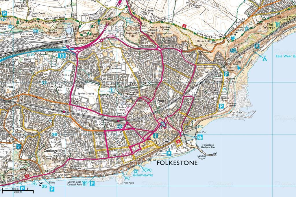
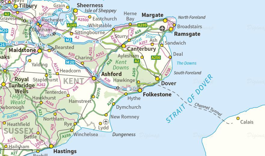
3 Where is Folkestone?

4 Where are the sites for the fieldwork? Write down 3 key points about the 3 sites using the map.
5 Why are we doing the fieldwork? The aim of the fieldwork is to gather data for the Coast Assessment. This is your own project so you can choose how you direct your investigation. We will provide two choices for your key question.
6 Key Questions 1. What evidence is there of processes along the coast? 2. How successful has coastal management been? All groups will collect evidence for both.
7 What evidence is there of processes along the coast? Measure longshore drift at both site 1 and site 2. Take pictures of size of sediment at both site 1 and site 2. Ideas of things to discuss: Are there any landforms of erosion along the coast? Is longshore drift happening? Are there any beaches? What are the waves like? Is there more (erosion/transport/deposition) at site 1 or site 2
8 How successful has coastal management been? Take photos of the different management strategies. Use a bi-polar evaluation to evaluate the strategies. Ask the local people what they think of the defences? Ideas of things to discuss: Has the impact of processes been reduced as a result of the management strategies? (ties into first Q) What are the advantages and disadvantages of the different management strategies? Do they benefit the people? Why are they there?
9 Methods Measuring longshore drift: Decide on an appropriate distance to measure longshore drift over, for example 10 metres Lay out tape measure close to water and mark start and finish points Place your float into water in the breakwater zone (where the wave crests and you can see white) at the start point Observe and time the object's movement across the pre-set distance Repeat 3 times.
10 Limitations to Method Tidal and wind conditions, the size and weight of float used and the slope angle of the beach may all affect measurements Take note of the wind speed and direction on the day the fieldwork is undertaken as this may affect the speed at which the float is transported. This is particularly important if further sampling for the investigation is undertaken on another day Obstructions to the movement of float, for example rocky outcrops, may affect results. Floats may be lost during the investigation. Repeated experiments or the use of more than one marker can reduce this problem Floats should be placed in the water ahead of the start line to allow them to settle prior to recording, and avoid giving the floats extra momentum The float should lie low in the water to ensure that it is not influenced by the wind The measuring should be undertaken in an area where there are no swimmers or paddlers for safety reasons and to ensure the reliability of results Any anomalies should be recorded, for example obstructions which may affect the movement of the float Weather and sea conditions can have a dramatic affect on observations
11 Task Think about which question you would like to investigate. Brainstorm some ideas or questions you would like to answer that are related to your chosen key question. Extension: Add images of Sunny Sands, The Leas, and the pebble beach to your maps.
12 What you need to bring: Clipboard Pencil Camera Money/lunch Sensible clothes and walking shoes no jeans! An orange Stopwatch Waterproof
Imagine that you can see a side view of a wave as it approaches a beach. Describe how the wave changes as the wave approaches the beach.
 Geology 101 Name Reading Guide for Ch. 19: Shores and Coastal Processes (p. 612) Waves, Currents, and Tides (p. 614) Waves and Currents (p. 614) Imagine that you can see a side view of a wave as it approaches
TITLE: COASTAL EROSION AND LANDFORMS.
 TITLE: COASTAL EROSION AND LANDFORMS. AIM: What are the factors that influence the formation of coastal features along Fishing Pond beach Trinidad? LOCATION OF FIELD STUDY: The study was carried out in
Label the diagram below with long fetch and short fetch:
 Coastal Processes Coasts are shaped by the sea and the action of waves. The processes that take place are erosion, transportation and deposition. The power of waves is one of the most significant forces
/50. Physical Geology Shorelines
 Physical Geology Shorelines Multiple Guess: (You know the drill 2 points each) 1. The path of movement of a water particle in a wave at sea is 1. circular 2. horizontal 3. vertical 4. elliptical 5. none
Earth Science Chapter 16 Section 3 Review
 Name: Class: Date: Earth Science Chapter 16 Section 3 Review Multiple Choice Identify the choice that best completes the statement or answers the question. 1. The movement of water that parallels the shore
Site The fieldwork should be completed at a localised site on the Victorian coast (or elsewhere).
.") Coastal fieldwork Studying the coast provides the opportunity to conduct fieldwork in coastal regions. This fieldwork could investigate the geographic characteristics of the coast and how they change over
Coastal fieldwork Studying the coast provides the opportunity to conduct fieldwork in coastal regions. This fieldwork could investigate the geographic characteristics of the coast and how they change over
Coasts. 1. Coastal Processes. 1.1 Coastal erosion. 1.2 Sediment transport. Coastal Processes and Landforms. i. Hydraulic action
 Coasts Coastal Processes and Landforms 1. Coastal Processes 1.1 Coastal erosion i. Hydraulic action When waves strike against a rock surface, the waves trap air in the rock joints. This air is compressed
Nearshore Sediment Transport What influences the loss of sediment on Beaches? - Waves - Winds - Tidal Currents - River discharge - Runoff
 Tides & Beaches Nearshore Sediment Transport What influences the loss of sediment on Beaches? - Waves - Winds - Tidal Currents - River discharge - Runoff Oceans Ocean Topography Physical Structure of the
SHOREHAM BEACH LOCAL NATURE RESERVE
 SHOREHAM BEACH LOCAL NATURE RESERVE Coastal Geography Education Programme 2014-15 S. Savage 2014 COASTAL GEOGRAPHY OPPORTUNITIES Shoreham Beach Shoreham Beach is a shingle spit formed over many centuries
Identify one factor which influences wave strength (1 Mark) Factors which affect wave strength
 Factors which affect wave strength") Coasts revision Identify one factor which influences wave strength (1 Mark) Factors which affect wave strength Identify one factor which influences wave strength (1 Mark) Factors which affect wave strength
Coasts revision Identify one factor which influences wave strength (1 Mark) Factors which affect wave strength Identify one factor which influences wave strength (1 Mark) Factors which affect wave strength
Australian Coastal Councils Conference
 Australian Coastal Councils Conference Kiama March 2019 Where Has My Beach Gone? (and what can I do about it?) Dr Andrew McCowan Water Technology Where Has My Beach Gone? Where Has My Beach Gone? Where
GCSE GEOGRAPHY YR 11 KNOWLEDGE BOOK FIELDWORK
 GCSE GEOGRAPHY YR 11 KNOWLEDGE BOOK FIELDWORK PHYSICAL STUDY Page 1 PHYSICAL STUDY: HARD ENGINEERING IS CONTROLLING LONGSHORE DRIFT AT SHERINGHAM The information here is what students MUST know. If you
Name: Form: 2.To know the difference between Constructive and Destructive wave # $
 Name: Form: Landforms and landscape processes: COASTS 1. To know what factors affect the strength of waves # $ 2.To know the difference between Constructive and Destructive wave # $ 3. To be able to draw
Define the key terms: - Abrasion - Attrition - Hydraulic action - Solution. Y11 Coasts
 Define the key terms: - Abrasion - Attrition - Hydraulic action - Solution Abrasion caused by waves picking up material which is forced against the cliff face wearing it away Attrition where stones and
0460 GEOGRAPHY. 0460/41 Paper 4 (Alternative to Coursework), maximum raw mark 60
, maximum raw mark 60") CAMBRIDGE INTERNATIONAL EXAMINATIONS Cambridge International General Certificate of Secondary Education MARK SCHEME for the May/June 2015 series 0460 GEOGRAPHY 0460/41 Paper 4 (Alternative to Coursework),
CAMBRIDGE INTERNATIONAL EXAMINATIONS Cambridge International General Certificate of Secondary Education MARK SCHEME for the May/June 2015 series 0460 GEOGRAPHY 0460/41 Paper 4 (Alternative to Coursework),
Chapter - Oceans and Coasts
 Chapter - Oceans and Coasts Discussion: What do oceans contribute to the environment of Earth? How do Earth s major systems relate to the oceans? Oceans and Coasts Oceans are important - Thermal regulation
Coastal Processes and Landforms
 Coastal Processes and Landforms These icons indicate that teacher s notes or useful web addresses are available in the Notes Page. This icon indicates that the slide contains activities created in Flash.
MARK SCHEME for the October/November 2014 series 0460 GEOGRAPHY. 0460/41 Paper 4 (Alternative to Coursework), maximum raw mark 60
, maximum raw mark 60") CAMBRIDGE INTERNATIONAL EXAMINATIONS Cambridge International General Certificate of Secondary Education MARK SCHEME for the October/November 2014 series 0460 GEOGRAPHY 0460/41 Paper 4 (Alternative to Coursework),
CAMBRIDGE INTERNATIONAL EXAMINATIONS Cambridge International General Certificate of Secondary Education MARK SCHEME for the October/November 2014 series 0460 GEOGRAPHY 0460/41 Paper 4 (Alternative to Coursework),
Exemplar for Internal Assessment Resource Geography Level 3. Resource title: The Coastal Environment Kaikoura
 Exemplar for internal assessment resource Geography 3.5A for Achievement Standard 91430 Exemplar for Internal Assessment Resource Geography Level 3 Resource title: The Coastal Environment Kaikoura This
OCEANS. Main Ideas. Lesson 2: Ocean Currents Ocean Currents help distribute heat around Earth.
 Oceans Chapter 10 OCEANS Main Ideas Lesson 2: Ocean Currents Ocean Currents help distribute heat around Earth. Lesson 3: The Ocean Shore The shore is shaped by the movement of water and sand. OCEANS SO
Deep-water orbital waves
 What happens when waves approach shore? Deep-water orbital waves Fig. 9.16, p. 211 Wave motion is influenced by water depth and shape of the shoreline wave buildup zone surf zone beach Wave base deepwater
Formation and characteristics of different types of beaches
 Activity Title: Formation and characteristics of different types of beaches Focusing questions What different types of beaches are there in New Zealand? How are estuaries different to open coastal sandy
1.5 How do ocean waves and currents change the face of coastal areas? (Chapter 3)
") 1.5 How do ocean waves and currents change the face of coastal areas? (Chapter 3) 1. Hydraulic Action/Pressure - air being forced into crack in rocks. 2. Corrosion (Solution) Minerals such as calcium carbonate
1.5 How do ocean waves and currents change the face of coastal areas? (Chapter 3) 1. Hydraulic Action/Pressure - air being forced into crack in rocks. 2. Corrosion (Solution) Minerals such as calcium carbonate
Coastal Processes and Landforms
 Coastal Processes and Landforms These icons indicate that teacher s notes or useful web addresses are available in the Notes Page. This icon indicates that the slide contains activities created in Flash.
MESSOLOGI LAGOON AREA (GREECE)
") MESSOLOGI LAGOON AREA (GREECE) 20 Contact: Kyriakos SPYROPOULOS TRITON Consulting Engineers 90 Pratinou Str. 11634 Athens (GREECE) Tel: +32 10 729 57 61 Fax: +32 10 724 33 58 e-mail: kspyropoulos@tritonsa.gr
MESSOLOGI LAGOON AREA (GREECE) 20 Contact: Kyriakos SPYROPOULOS TRITON Consulting Engineers 90 Pratinou Str. 11634 Athens (GREECE) Tel: +32 10 729 57 61 Fax: +32 10 724 33 58 e-mail: kspyropoulos@tritonsa.gr
Anatomy of Coastal Regions
 The Coast I. BEACH ANATOMY Anatomy of Coastal Regions Terms for different parts of beaches and coastal regions Are all about ENERGY- ie, where the ocean s energy Mostly through tides and waves, and shape
Contents. What is a Walking Zone? 1 About the Pack 1 What the Schools say about the Wow Walking Zone 2. 5 Week Lesson Plan 3 Walking Zone Maps 8
 Contents What is a Walking Zone? 1 About the Pack 1 What the Schools say about the Wow Walking Zone 2 5 Week Lesson Plan 3 Walking Zone Maps 8 Photocopiable Resources Double Bubble Map - How WoW is good
Q1. What are the primary causes/contributors to coastal erosion at Westshore and the concept of longshore / littoral drift.
 Q1. What are the primary causes/contributors to coastal erosion at Westshore and the concept of longshore / littoral drift. In order of (timing related) contribution to present problem 1. Beach is too
Modeling Beach Erosion
 Ocean Lecture & Educator s Night May 16, 2012 Modeling Beach Erosion Below is an overview of the activity Modeling Beach Erosion (New Jersey Sea Grant Consortium, Education Program) to incorporate information
Constructive waves build beaches. Each wave is low. As the wave breaks it carries material up the beach in its. material will then be deposited as
 Constructive waves Constructive waves build beaches. Each wave is low. As the wave breaks it carries material up the beach in its swash. The beach material will then be deposited as the backwash soaks
Case study 64. Shoreham Harbour Shingle Bypassing and Recycling
 Case study 64. Shoreham Harbour Shingle Bypassing and Recycling Authors: Tony Parker, Uwe Dornbusch Main driver: Improved defences Project stage: Ongoing construction/operation since 1992 Photo 1: Shoreham
LAB: WHERE S THE BEACH
 Name: LAB: WHERE S THE BEACH Introduction When you build a sandcastle on the beach, you don't expect it to last forever. You spread out your towel to sunbathe, but you know you can't stay in the same spot
RAINBOW BAY FIELD REPORT
 RAINBOW BAY FIELD REPORT Contents Page Abstract 1.0 Introduction.. 2.0 Methodology 2.1 Limitations.. 3.0 Statement of Findings. 3.1 History. 3.2 Data Collection. 3.2.1 Observations. 3.2.2 Management Strategies
SEDIMENT BUDGET OF LIDO OF PELLESTRINA (VENICE) Written by Marcello Di Risio Under the supervision of Giorgio Bellotti and Leopoldo Franco
 Written by Marcello Di Risio Under the supervision of Giorgio Bellotti and Leopoldo Franco") SEDIMENT BUDGET OF LIDO OF PELLESTRINA (VENICE) Written by Marcello Di Risio Under the supervision of Giorgio Bellotti and Leopoldo Franco Table of contents: 1. Introduction...3 2. Protection structures
SEDIMENT BUDGET OF LIDO OF PELLESTRINA (VENICE) Written by Marcello Di Risio Under the supervision of Giorgio Bellotti and Leopoldo Franco Table of contents: 1. Introduction...3 2. Protection structures
PLANNING A TRIP TO THE SEASHORE CHECK LIST
 PLANNING A TRIP TO THE SEASHORE CHECK LIST Action: 1. Access / Facilities 2. Risk Assessment 3. First Aid / Emergency 4. Tide Tables / Changing Tides / Weather forecast 5. Volunteers 6. Plan the Day of
Cambridge International Examinations Cambridge International General Certificate of Secondary Education
 Cambridge International Examinations Cambridge International General Certificate of Secondary Education *1089858088* GEOGRAPHY 0460/43 Paper 4 Alternative to Coursework May/June 2016 Candidates answer
Risk Assessment Fieldwork Techniques (covering all techniques used in field studies, excursion and science-based modules)
") Fieldwork Techniques Assessment Form Issued: 05/01/2018 v.2018.1.0 Ref: PROG-BRA-016 Assessment Fieldwork Techniques (covering all techniques used in field studies, excursion and science-based modules)
Fieldwork Techniques Assessment Form Issued: 05/01/2018 v.2018.1.0 Ref: PROG-BRA-016 Assessment Fieldwork Techniques (covering all techniques used in field studies, excursion and science-based modules)
CHAPTER 8 ASSESSMENT OF COASTAL VULNERABILITY INDEX
 124 CHAPTER 8 ASSESSMENT OF COASTAL VULNERABILITY INDEX 8.1 INTRODUCTION In order to assess the vulnerability of the shoreline considered under this study against the changing environmental conditions,
Coastal Change and Conflict
 Coastal Change and Conflict Outline of the Topic Contrasting Coasts why do all coasts not look the same? Geology of the coast the impact rock structure has on the coastline Waves Constructive and destructive
Among the numerous reasons to develop an understanding of LST are:
 Longshore Sediment Transport Among the numerous reasons to develop an understanding of LST are: Process by which the products of terrestrial erosion (riverine sediments, sea cliff failures, etc.) are removed
The Physical and Human Causes of Erosion. The Holderness Coast
 The Physical and Human Causes of Erosion The Holderness Coast By The British Geographer Situation The Holderness coast is located on the east coast of England and is part of the East Riding of Yorkshire;
Site: London Bridge. Some further information about London Bridge can be found at the Parks Victoria website
 Site: London Bridge About London Bridge London Bridge is located at the Portsea Back Beach which is approximately 3 kilometres south of Portsea. This site provides students with excellent examples of coastal
COASTS (P.38-45) Management: Hard engineering: Groynes Sea walls Gabions Soft Engineering: Beach replenishment Dune regeneration
 Management: Hard engineering: Groynes Sea walls Gabions Soft Engineering: Beach replenishment Dune regeneration") COASTS (P.38-45) Processes: Types of wave Weathering Mass Movement Erosion Transport Deposition Landforms: Cracks Caves Arches Stacks/stumps Headlands/bays Coves Spits Tombolos Beaches Sand dunes Management:
COASTS (P.38-45) Processes: Types of wave Weathering Mass Movement Erosion Transport Deposition Landforms: Cracks Caves Arches Stacks/stumps Headlands/bays Coves Spits Tombolos Beaches Sand dunes Management:
Ocean Waves. Capillary. Gravity. Wind generated. Tides Tsunamis Seiches
 Ocean Waves Capillary Wind generated Gravity Tides Tsunamis Seiches Capillary waves are driven by the surface tension produced by electrically polarized water molecule San Pedro Lighthouse Waves are alternate
Low-crested offshore breakwaters: a functional tool for beach management
 Environmental Problems in Coastal Regions VI 237 Low-crested offshore breakwaters: a functional tool for beach management K. Spyropoulos & E. Andrianis TRITON Consulting Engineers, Greece Abstract Beach
Oceans and Coasts. Chapter 18
 Oceans and Coasts Chapter 18 Exploring the oceans The ocean floor Sediments thicken and the age of the seafloor increases from ridge to shore The continental shelf off the northeast United States Constituent
The Sea Geography Notes JC-Learn. JC-Learn. Geography Notes The Sea. 1 P a g e
 JC-Learn Geography Notes The Sea 1 P a g e The Sea *Here, you can choose to study the chapter on glaciation or the one on the sea, or even both, because whenever these topics come up in the Junior Cert
Reading Material. Inshore oceanography, Anikouchine and Sternberg The World Ocean, Prentice-Hall
 Reading Material Inshore oceanography, Anikouchine and Sternberg The World Ocean, Prentice-Hall BEACH PROCESSES AND COASTAL ENVIRONMENTS COASTAL FEATURES Cross section Map view Terminology for Coastal
Chapter 10 Lecture Outline. The Restless Oceans
 Chapter 10 Lecture Outline The Restless Oceans Focus Question 10.1 How does the Coriolis effect influence ocean currents? The Ocean s Surface Circulation Ocean currents Masses of water that flow from one
page - Laboratory Exercise #5 Shoreline Processes
 page - Laboratory Exercise #5 Shoreline Processes Section A Shoreline Processes: Overview of Waves The ocean s surface is influenced by three types of motion (waves, tides and surface currents). Shorelines
Oceans in Motion: Waves and Tides
 Oceans in Motion: Waves and Tides Waves Waves are among the most familiar features in the ocean. All waves work similarly, so although we are talking about ocean waves here, the same information would
General Coastal Notes + Landforms! 1
 General Coastal Notes + Landforms! 1 Types of Coastlines: Type Description Primary Coast which is essentially in the same condition when sea level stabilized Coastline after the last ice age, younger.
Physical Modeling of Nearshore Placed Dredged Material Rusty Permenter, Ernie Smith, Michael C. Mohr, Shanon Chader
 Physical Modeling of Nearshore Placed Dredged Material Rusty Permenter, Ernie Smith, Michael C. Mohr, Shanon Chader Research Hydraulic Engineer ERDC-Coastal Hydraulics Laboratory October 25,2012 Study
IMPACTS OF COASTAL PROTECTION STRATEGIES ON THE COASTS OF CRETE: NUMERICAL EXPERIMENTS
 IMPACTS OF COASTAL PROTECTION STRATEGIES ON THE COASTS OF CRETE: NUMERICAL EXPERIMENTS Tsanis, I.K., Saied, U.M., Valavanis V. Department of Environmental Engineering, Technical University of Crete, Chania,
GCSE 4241/02 GEOGRAPHY SPECIFICATION B HIGHER TIER UNIT 1
 Surname Other Names Centre Number 0 Candidate Number GCSE 4241/02 GEOGRAPHY SPECIFICATION B HIGHER TIER UNIT 1 P.M. TUESDAY, 4 June 2013 1 hour For examiner s use Question 1 Question 2 Total Marks 30 30
TITLE: North Carolina s Changing Shorelines. KEYWORDS: erosion - shorelines - mapping - sustainability
 UNC Coastal Studies Institute Teacher Resources 1 TITLE: North Carolina s Changing Shorelines KEYWORDS: erosion - shorelines - mapping - sustainability Changing shorelines impact coastal infrastructure.
Our Council s Own: Oceanography Cadette/Senior/Ambassador Badge
 Our Council s Own: Oceanography Cadette/Senior/Ambassador Badge Oceanography: The science that deals with oceans, the delimitation of their extent and depth, the physics and chemistry of their water, marine
1.1 Coastal processes produce landforms
 1.1 Coastal processes produce landforms Types of wave: destructive and constructive Destructive Carry out erosion Tall Powerful High frequency Backwash greater than the swash Take sediment from beach to
GCSE GEOGARPHY OCR B REVISION GUIDE Coasts
 GCSE GEOGARPHY OCR B REVISION GUIDE Coasts Definition: The interface between land and sea. Coastal regions cover only 10% of the inhabited land space, yet they are home to more than 60% of the world s
OCEAN WAVES NAME. I. Introduction
 NAME OCEAN WAVES I. Introduction The physical definition of a wave is a disturbance that transmits energy from one place to another. In the open ocean waves are formed when wis blowing across the water
COASTAL ENVIRONMENTS. 454 lecture 12
 COASTAL ENVIRONMENTS Repeated movement of sediment & water constructs a beach profile reflecting the balance between average daily or seasonal wave forces and resistance of landmass to wave action Coasts
Modeling Sediment Transport Along the Upper Texas Coast
 Modeling Sediment Transport Along the Upper Texas Coast David B. King Jr. Jeffery P. Waters William R. Curtis Highway 87 roadbed, Jefferson County Galveston District Corps Sabine Pass to San Luis Pass
SELECTION OF THE PREFERRED MANAGEMENT OPTION FOR STOCKTON BEACH APPLICATION OF 2D COASTAL PROCESSES MODELLING
 SELECTION OF THE PREFERRED MANAGEMENT OPTION FOR STOCKTON BEACH APPLICATION OF 2D COASTAL PROCESSES MODELLING C Allery 1 1 DHI Water and Environment, Sydney, NSW Abstract This paper presents an approach
NORTHERN CELL OPTIONS SHORTLIST RECOMMENDATIONS
 OPTIONS SHORTLIST RECOMMENDATIONS Coastal Unit C: Bayview Options recommended for MCDA scoring. Status quo. Planting 3. Renourishment (gravel) 6. Beach-scraping 7. Restore shingle crest. Inundation accommodation
4/20/17. #31 - Coastal Erosion. Coastal Erosion - Overview
 Writing Assignment Due Monday by 11:59 pm #31 - Coastal Erosion Beach front property! Great View! Buy now at a great price! See main class web pages for detailed instructions Essays will be submitted in
Shorelines Earth - Chapter 20 Stan Hatfield Southwestern Illinois College
 Shorelines Earth - Chapter 20 Stan Hatfield Southwestern Illinois College The Shoreline A Dynamic Interface The shoreline is a dynamic interface (common boundary) among air, land, and the ocean. The shoreline
4/20/17. #32 - Coastal Erosion Case Histories - Lake Michigan
 Writing Assignment Due Monday by 11:59 pm #32 - Coastal Erosion Case Histories - Lake Michigan See main class web pages for detailed instructions Submit papers Illinois Compass No copying: Compass will
Julebæk Strand. Effect full beach nourishment
 Julebæk Strand Effect full beach nourishment Aim of Study This study is a part of the COADAPT funding and the aim of the study is to analyze the effect of beach nourishment. In order to investigate the
Today: Coastal Issues and Estuaries
 Today: Coastal Issues and Estuaries Coastal issues Human effect on coastlines What is an estuary Why are they so important? Circulation of water in estuary Environmental issues Coastal Issues: Problem
1.5 Understand how ocean waves and currents change the face of coastal areas. (Chapter 3)
") 1.5 Understand how ocean waves and currents change the face of coastal areas. (Chapter 3) 1. Hydraulic Action/Pressure - air being forced into crack in rocks. 2. Corrosion (Solution) Minerals such as calcium
1.5 Understand how ocean waves and currents change the face of coastal areas. (Chapter 3) 1. Hydraulic Action/Pressure - air being forced into crack in rocks. 2. Corrosion (Solution) Minerals such as calcium
Greg Berman (WHOI Sea Grant & Cape Cod Cooperative Extension) November 2, 2017
 November 2, 2017") November 2, 2017 Are You Ready for the Next Big Storm?: A Workshop for Hardy Cape Codders Greg Berman (WHOI Sea Grant & Cape Cod Cooperative Extension) Outline: ~30 min talk & time for questions Practical
November 2, 2017 Are You Ready for the Next Big Storm?: A Workshop for Hardy Cape Codders Greg Berman (WHOI Sea Grant & Cape Cod Cooperative Extension) Outline: ~30 min talk & time for questions Practical
July 14, The Beaches Conference Greg Berman (WHOI Sea Grant & Cape Cod Cooperative Extension)
") July 14, 2017 The Beaches Conference 2017 Greg Berman (WHOI Sea Grant & Cape Cod Cooperative Extension) Annual downscaled global tropical cyclones, averaged over the six models. Uses data from IPCC Fifth
July 14, 2017 The Beaches Conference 2017 Greg Berman (WHOI Sea Grant & Cape Cod Cooperative Extension) Annual downscaled global tropical cyclones, averaged over the six models. Uses data from IPCC Fifth
Concepts & Phenomena
 Concepts & Phenomena in coastal and port sedimentation R. Kamalian Ports and Maritime Organization of Iran and PIANC-Iran 7 9 December 2015 What is the problem? Many harbours have sedimentation problems
Waves- how are they formed and how do they affect the coast?
 Question 7 Coasts Waves- how are they formed and how do they affect the coast? Waves are caused by friction between the wind and water causing the water to swell. The size and energy of a wave is influenced
Questions # 4 7 refer to Figure # 2 (page 321, Fig )
") Shoreline Community College OCEANOGRAPHY 101 Fall 2006 Sample Exam # 3 Instructor: Linda Khandro Questions # 1 3 refer to Figure # 1 (page 284, Fig 11.7) 1. At which position is the moon in its new moon
Shoreline Community College OCEANOGRAPHY 101 Fall 2006 Sample Exam # 3 Instructor: Linda Khandro Questions # 1 3 refer to Figure # 1 (page 284, Fig 11.7) 1. At which position is the moon in its new moon
INVESTIGATING STRATEGIES TO REPAIR HISTORIC TIDE WALLS ON THE CLARENCE RIVER AND ADJACENT BEACH AND RIVER BANK PROTECTION
 INVESTIGATING STRATEGIES TO REPAIR HISTORIC TIDE WALLS ON THE CLARENCE RIVER AND ADJACENT BEACH AND RIVER BANK PROTECTION I Jayewardene 1, A Hartley 2, B Blumberg 1, E Couriel 1 1 NSW Water Solutions,
Directed Reading. Section: Ocean Currents. a(n). FACTORS THAT AFFECT SURFACE CURRENTS
. FACTORS THAT AFFECT SURFACE CURRENTS") Skills Worksheet Directed Reading Section: Ocean Currents 1. A horizontal movement of water in a well-defined pattern is called a(n). 2. What are two ways that oceanographers identify ocean currents? 3.
Skills Worksheet Directed Reading Section: Ocean Currents 1. A horizontal movement of water in a well-defined pattern is called a(n). 2. What are two ways that oceanographers identify ocean currents? 3.
Variation in Beach Profile and Sediment Characteristics at Popham Beach, Phippsburg, ME
 Colby College Digital Commons @ Colby Undergraduate Research Symposium Student Research 2006 Variation in Beach Profile and Sediment Characteristics at Popham Beach, Phippsburg, ME Kathryn Lidington Colby
Lecture Outlines PowerPoint. Chapter 15 Earth Science, 12e Tarbuck/Lutgens
 Lecture Outlines PowerPoint Chapter 15 Earth Science, 12e Tarbuck/Lutgens 2009 Pearson Prentice Hall This work is protected by United States copyright laws and is provided solely for the use of instructors
Plot the Path. Mary Anne Otten. lesson three
 Plot the Path Mary Anne Otten lesson three Subject/Grade: Grade 2, Math, Social Studies, Science Duration: one class period Materials needed: Per class: Day the Great Lakes Drained Away by Charles Ferguson
EXAMPLE NEA INVESTIGATION A-LEVEL GEOGRAPHY (7037) A-LEVEL. Marked investigation with commentary
 A-LEVEL. Marked investigation with commentary") A-LEVEL A-LEVEL GEOGRAPHY (7037) EXAMPLE NEA INVESTIGATION Marked investigation with commentary An example investigation folder with completed proposal form and examiner commentary How do the characteristics
A-LEVEL A-LEVEL GEOGRAPHY (7037) EXAMPLE NEA INVESTIGATION Marked investigation with commentary An example investigation folder with completed proposal form and examiner commentary How do the characteristics
COASTAL MANAGEMENT AND PROTECTION METHODS! 1
 COASTAL MANAGEMENT AND PROTECTION METHODS! 1 Strategy What it does Cons Pros Examples SOFT ENGINEERING: The use of ecological principles and practices to reduce erosion and achieve the stabilization and
Shoreline Response to an Offshore Wave Screen, Blairgowrie Safe Boat Harbour, Victoria, Australia
 Shoreline Response to an Offshore Wave Screen, Blairgowrie Safe Boat Harbour, Victoria, Australia T.R. Atkins and R. Mocke Maritime Group, Sinclair Knight Merz, P.O. Box H615, Perth 6001, Australia ABSTRACT
VLH Ltd, Nereide Ltd, Saltlake Resorts Ltd Proposed Beach Erosion Protection Works at Bel Ombre Environmental Impact Assessment
 VLH Ltd, Nereide Ltd, Saltlake Resorts Ltd Proposed Beach Erosion Protection Works at Bel Ombre TATO/EIA/01 Issue 15 February 2017 This report takes into account the particular instructions and requirements
Nearshore Waves and Erosion Model Quantifying the Coastal Protection Benefits Provided by Natural Habitats
 Nearshore Waves and Erosion Model Quantifying the Coastal Protection Benefits Provided by Natural Habitats SaveGuanaCayReef Marinehindsight.com Necessary to quantify protection services offered by natural
4/20/17. #30 - Coastlines - General Principles Coastlines - Overview
 Writing Assignment Due one week from today by 11:59 pm See main class web pages for detailed instructions Essays will be submitted in Illinois Compass (instructions later) Pick one: Earthquakes, tsunamis,
INTRODUCTION TO COASTAL ENGINEERING
 The University of the West Indies Organization of American States PROFESSIONAL DEVELOPMENT PROGRAMME: COASTAL INFRASTRUCTURE DESIGN, CONSTRUCTION AND MAINTENANCE A COURSE IN COASTAL DEFENSE SYSTEMS I CHAPTER
Environmental Protection on the Gold Coast of Queensland, Australia. 1. What is the appeal of the Gold Coast to tourists?
 Environmental Protection on the Gold Coast of Queensland, Australia Sections 1. What is the appeal of the Gold Coast to tourists? 2. How are Gold Coast visitor trends changing? 3. How can the impacts of
INFLUENCE OF DAMAGED GROINS ON NOURISHED SEASHORE
 INFLUENCE OF DAMAGED GROINS ON NOURISHED SEASHORE Ostrowski R 1., Pruszak Z. 1, Schönhofer J. 1, Szmytkiewicz M. 1, Szmytkiewicz P. 1 The system of timber palisade groins can be very helpful as a measure
Chartwork Learn the basics for position fixing using a number of techniques and a simple equation for speed, distance and time.
 Chartwork Learn the basics for position fixing using a number of techniques and a simple equation for speed, distance and time. Chartwork Chartwork Tools Accurate chart work is the basis for good navigation.
Natural Bridges Field Trip Activity
 Natural Bridges Field Trip Activity This is due in class on MONDAY- March 1 - not in sections! Name TA: NOTE ON THE GRADING OF THIS ASSIGNMENT: Many of the questions below (especially in the tidepool part)
Beach Profiles: Monitoring Sea Level Rise. Student Activity Sheet. Name Date Class
 Beach Profiles: Monitoring Sea Level Rise Student Activity Sheet Name Date Class A shoreline is the area where the water and land meet. This is where we find beach: areas where sediments (sand or other
NCCOE EA Coastal Adaptation Guidelines. Section I Emerging Technology Novel Alternative Approaches to Coastal Erosion
 NCCOE EA Coastal Adaptation Guidelines Section I Emerging Technology Novel Alternative Approaches to Coastal Erosion Alessio Mariani, Doug Lord, Tony Webb James Carley, Matt Blacka, Brett Miller Ian Turner,
LAKKOPETRA (GREECE) EUROSION Case Study. Contact: Kyriakos SPYROPOULOS. TRITON Consulting Engineers. 90 Pratinou Str Athens (GREECE)
 EUROSION Case Study. Contact: Kyriakos SPYROPOULOS. TRITON Consulting Engineers. 90 Pratinou Str Athens (GREECE)") LAKKOPETRA (GREECE) Contact: Kyriakos SPYROPOULOS TRITON Consulting Engineers 90 Pratinou Str. 11634 Athens (GREECE) Tel: +32 10 729 57 61 Fax: +32 10 724 33 58 e-mail: kspyropoulos@tritonsa.gr 19 1 1.
LAKKOPETRA (GREECE) Contact: Kyriakos SPYROPOULOS TRITON Consulting Engineers 90 Pratinou Str. 11634 Athens (GREECE) Tel: +32 10 729 57 61 Fax: +32 10 724 33 58 e-mail: kspyropoulos@tritonsa.gr 19 1 1.
SAND BOTTOM EROSION AND CHANGES OF AN ACTIVE LAYER THICKNESS IN THE SURF ZONE OF THE NORDERNEY ISLAND
 SAND BOTTOM EROSION AND CHANGES OF AN ACTIVE LAYER THICKNESS IN THE SURF ZONE OF THE NORDERNEY ISLAND Kos'yan R. 1, Kunz H. 2, Podymov l. 3 1 Prof.Dr.,The Southern Branch of the P.P.Shirshov Institute
CHAPTER 231 OFFSHORE BREAKWATERS VERSUS BEACH NOURISHMENTS A COMPARISON
 CHAPTER 231 OFFSHORE BREAKWATERS VERSUS BEACH NOURISHMENTS A COMPARISON M. Pluijm 1, J.C. van der Lem 2, A.W. Kraak 3, J.H.W. de Ruig 4 ABSTRACT In the last decades two methods of coastal protection have
Sandy Beach Morphodynamics. Relationship between sediment size and beach slope
 Sandy Beach Morphodynamics Relationship between sediment size and beach slope 1 Longshore Sorting - Willard Bascom Beach Slope, Grain Size, and Wave Energy Beach at Sandwich Bay, Kent, UK near the Straights
OECS Regional Engineering Workshop September 29 October 3, 2014
 B E A C H E S. M A R I N A S. D E S I G N. C O N S T R U C T I O N. OECS Regional Engineering Workshop September 29 October 3, 2014 Coastal Erosion and Sea Defense: Introduction to Coastal Dynamics David
VENICE LOCAL COASTAL PROGRAM UPDATE: COASTAL HAZARDS WELCOME
 VENICE LOCAL COASTAL PROGRAM UPDATE: COASTAL HAZARDS WELCOME 1 Introducing the Team Hosted by the Department of City Planning and grant funded in part by the California Coastal Commission 2 Workshop Purpose
LABORATORY EXPERIMENTS ON EROSION CONTROL PERFORMANCE OF AN L- SHAPED PERMEABLE STRUCTURE. Abstract
 LABORATORY EXPERIMENTS ON EROSION CONTROL PERFORMANCE OF AN L- SHAPED PERMEABLE STRUCTURE Yuuji Maeda 1, Masayuki Unno 2, Masafumi Sato 2, Takao Kurita 2, Takaaki Uda 3 and Shinji Sato 4 Abstract A new