Virginia Beach, Virginia Beach Re-Nourishment Projects: Sandbridge Beach and Resort Beach
|
|
|
- Moris Wilkins
- 5 years ago
- Views:
Transcription
1 Virginia Beach, Virginia Beach Re-Nourishment Projects: Sandbridge Beach and Resort Beach Norfolk District City of Virginia Beach US Army Corps of Engineers Jim White The views, opinions and findings contained in this report are those of the authors(s) and should not be construed as an official Department of the Army position, policy or decision, unless so designated by other official documentation.
2
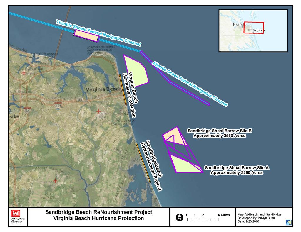
3 SANBRIDGE AND RESORT BEACH CURRENT STATUS AND CONSIDERATIONS Considerations Consolidating 2 projects Period of performance is preferred from March June Environmental window (September 1 st -November 14 th ) Total volume = about 3.5 MCY (Sandbridge= 2 MCY, VB = 1.5 MCY) UXO Potential in Borrow Sites; Screening and Safety Plans Req d Status Environmental Coordination almost complete Fully funded Borrow Site(s) Investigations Complete Ready to Advertise Both Projects - Late Nov/Early Dec. 3

4 File Name 4
 Dredge depth to -50 Looking to consolidate with Va Beach Resort if schedules can be maintained Beach placement 5 miles of beach on Sanbridge Beach 50 beach berm Requires turtle")
5 Sandbridge Beach Basic SOW: 2 MCY Requires grain size = D50 greater than 0.25 (Beach Quality Sand) Borrow sites is the Sandbridge Shoal, 3 mi. offshore, (next slide) Dredge depth to -50 Looking to consolidate with Va Beach Resort if schedules can be maintained Beach placement 5 miles of beach on Sanbridge Beach 50 beach berm Requires turtle monitoring and mitigation measures ToY Restrictions Sept 1- Nov 14


6 6 95SBVC-85 Legend Vibracore Locations SBVC-76 95SBVC SBVC-84 Condition 95SBVC SBVC SBVC SBVC-110 Good sand with notes 95SBVC SBVC-99 95SBVC SBVC SBVC-59 95SBVC SBVC SBVC-28 95SBVC-51 95SBVC-64 95SBVC-10 SAT SAT with notes SP SAT and UNSAT 95SBVC-9 95SBVC-40 95SBVC-41 95SBVC-29 95SBVC-50 95SBVC-27 95SBVC-62 95SBVC-11 UNSAT Wreck or Obstruction 95SBVC-74 95SBVC-39 95SBVC-12 95SBVC-7 95SBVC-66 95SBVC-13 95SBVC-6 95SBVC-38 Archeology Avoidance Area 95SBVC-73 Archology Avoidance Area Buffer 95SBVC-43 95SBVC SBVC-32 95SBVC-48 95SBVC-23 95SBVC-4 Current Borrow Area B 95SBVC-22 95SBVC-72 95SBVC-68 95SBVC-16 95SBVC-3 95SBVC-36 Historical Permit Area 95SBVC-61 95SBVC-53 95SBVC-37 95SBVC-15 Current Borrow Area A No Dredge Area 95SBVC-24 95SBVC-14 95SBVC-5 95SBVC-67 Sandbridge Shoal Borrow Site B 95SBVC-31 95SBVC-26 95SBVC-49 95SBVC-42 Reported Paleochannel Area Dredge Material Placement Area 95SBVC-58 95SBVC-30 95SBVC-25 95SBVC-52 95SBVC-8 95SBVC-65 UNSAT with notes not catagorized 95SBVC-44 95SBVC-56 95SBVC-60 95SBVC-54 95SBVC-21 95SBVC-33 95SBVC-17 95SBVC-69 95SBVC-2 95SBVC-35 95SBVC-18 95SBVC-1 95SBVC-45 95SBVC-82 95SBVC-20 95SBVC-72A 95SBVC-55 Bea ch ReN 95SBVC-34 95SBVC-19 95SBVC-46 95SBVC-92 95SBVC-80 95SBVC-97R1 95SBVC-97R2 95SBVC-70 95SBVC-78 95SBVC-71 ishm our 95SBVC-86 ent Pro 95SBVC-87 Norfolk District 95SBVC-95 95SBVC-91 95SBVC-94 95SBVC-93 File Name Sandbridge Shoal Borrow Areas Sandbridge Beach ReNourishment Project City of Virginia Beach, Virginia 95SBVC-89 Sandbridge Shoal Borrow Site A 95SBVC-96 95SBVC-88 ject US Army Corps of Engineers 95SBVC-83 95SBVC-81 95SBVC-79 95SBVC-90 I 0 2,500 5,000 Base Maps: ESRI Online 10,000 Feet Map: Sandbridge_borrow_boring_Mar2018pts Developed By: Karin Dridge Date: 3/7/2018
 Borrow sites are Thimble Shoals Channel and Atlantic Ocean Channel Dredge depth to -68 MLLW Looking to consolidate with Sandbridge if schedules can be maintained Beach")
7 Virginia BeachHurricane Protection Project Resort Beach Basic SOW: 1.5 MCY Requires grain size = D50 greater than 0.25 (Beach Quality Sand) Borrow sites are Thimble Shoals Channel and Atlantic Ocean Channel Dredge depth to -68 MLLW Looking to consolidate with Sandbridge if schedules can be maintained Beach placement from 2 nd Street to 60 th street approximately 50 beach berm Requires turtle monitoring and mitigation measures ToY Restrictions Sept 1- Nov 14
Dare County Nourishment Project Town of Duck
 Dare County Nourishment Project Town of Duck Julien Devisse, P.E. and Ken Willson CB&I / Coastal Planning & Engineering of North Carolina, Inc. February 15, 2017 A World of Solutions Outline Background
Assateague Island National Seashore North End Restoration Project Timeline
 Assateague Island National Seashore North End Restoration Project Timeline Date Event Some information provided in the Project Introduction document. Detailed events are available in a timeline compiled
Beach Nourishment Impact on Beach Safety and Surfing in the North Reach of Brevard County, Florida
 Beach Nourishment Impact on Beach Safety and Surfing in the North Reach of Brevard County, Florida Prepared by John Hearin, Ph.D. Coastal Engineering Vice Chairman Cocoa Beach Chapter Port Canaveral Patrick
US Beach Nourishment Experience:
 Beach Nourishment: Introduction of new sand to the beach by truck or dredge Large beach >1 million cubic yards (100,000 dump truck loads) Funding is a combination of federal, state, local & private Also
FINAL ENVIRONMENTAL IMPACT STATEMENT ON BROWARD COUNTY SHORE PROTECTION PROJECT SEGMENTS II AND III BROWARD COUNTY, FLORIDA
 FINAL ENVIRONMENTAL IMPACT STATEMENT ON BROWARD COUNTY SHORE PROTECTION PROJECT SEGMENTS II AND III BROWARD COUNTY, FLORIDA 1. PROJECT PURPOSE AND NEED 1.1. PROJECT AUTHORITY. 1.1.1. INITIAL AUTHORIZATION.
Changes in Beach Profile and Grain Size after Beach Renourishment
 Kevin Bodge, PE PhD Krista Egan, EI olsen associates, inc. and Mike McGarry Brevard County Natural Resources Mgt. Dept. Changes in Beach Profile and Grain Size after Beach Renourishment February 2018 Beach
Grays Harbor Federal Project
 Grays Harbor Federal Project Elizabeth Chien Coastal Navigation Program Manager Seattle District 27 October 2016 US Army Corps of Engineers Grays Harbor Navigation Channel Inner Harbor Dredging Summer
Threatened and Endangered Species Issues on the Kennebec River, Maine
 Acipenser brevirostrum Photo: Nancy Haley, NOAA http://digitalmedia.fws.gov/ Atlantic sturgeon photo courtesy of Robert Michelson http://www.nmfs.noaa.gov/stories/2012/01/31_atlantic_sturgeon.html Threatened
2018 Beach Preservation Project Information
 QUICK FACTS Beach Renourishment to begin late April 2018 o U.S. Army Corps of Engineers project o Project Area: 8 th St. E. to end of E. Ashley Ave. o Project Length: 2 miles o Cost: $10,900,000 o Funding:
Grays Harbor O&M and Deepening Dredging
 Grays Harbor O&M and Deepening Dredging Elizabeth Chien Project Manager Seattle District 28 January 2016 US Army Corps of Engineers Grays Harbor Navigation Channel Inner Harbor O&M Dredging Summer 2015:
Long Term Success and Future Approach of the Captiva and Sanibel Islands Beach Renourishment Program
 2017 National Conference on Beach Preservation Technology February 8-10, 2017; Stuart, Florida Long Term Success and Future Approach of the Captiva and Sanibel Islands Beach Renourishment Program Thomas
Atlantic Coast of Long Island, Jones Inlet to East Rockaway Inlet, Long Beach Island, NY Construction Update
 Atlantic Coast of Long Island, Jones Inlet to East Rockaway Inlet, Long Beach Island, NY Construction Update June 2016 US Army Corps of Engineers Project Purpose Three specific damage mechanisms of coastal
Tanya M. Beck. Kelly Legault. Research Physical Scientist Coastal & Hydraulics Lab, ERDC Vicksburg, MS
 Inlet And Adjacent Shoreline Processes at Cascading Time Scales Using the Coastal Modeling System and GenCade Tanya M. Beck Research Physical Scientist Coastal & Hydraulics Lab, ERDC Vicksburg, MS Kelly
Feasibility Report and Environmental Impact Statement. Coastal Storm Damage Reduction SURF CITY AND NORTH TOPSAIL BEACH, NORTH CAROLINA.
 Feasibility Report and Environmental Impact Statement on Coastal Storm Damage Reduction SURF CITY AND NORTH TOPSAIL BEACH, NORTH CAROLINA Appendix H Correspondence Appendix H Correspondence This appendix
Unalaska Navigation Channel Improvements
 1 237 237 237 255 255 255 0 0 0 Unalaska Navigation Channel Improvements 217 217 217 200 200 200 163 163 163 131 132 122 239 65 53 80 119 27 252 174.59 110 135 120 112 92 56 62 102 130 102 56 48 130 120
30 DAY PUBLIC NOTICE MAINTENANCE DREDGING OF THE 8-FOOT CHANNEL OF THE FEDERAL NAVIGATION PROJECT IN KENNEBUNK RIVER KENNEBUNK & KENNEBUNKPORT, ME
 fr.iiif.i ~ US Anny Corps of Engineers New England District 696 Virginia Road Concord, MA 01742-2751 Public Notice In Reply Refer to: Mr. Jack Karalius nae-pn-nav@usace.army.mil Programs/Project Management
RE: Hurricane Matthew Beach Damage Assessment and Recommendations [CSE 2416]
![RE: Hurricane Matthew Beach Damage Assessment and Recommendations [CSE 2416]](/thumbs/83/87675702.jpg "RE: Hurricane Matthew Beach Damage Assessment and Recommendations [CSE 2416]") October 25, 2016 Iris Hill Town Administrator Town of Edisto Beach 2414 Murray St Edisto Beach SC 29438 RE: Hurricane Matthew Beach Damage Assessment and Recommendations [CSE 2416] Dear Iris, Hurricane
October 25, 2016 Iris Hill Town Administrator Town of Edisto Beach 2414 Murray St Edisto Beach SC 29438 RE: Hurricane Matthew Beach Damage Assessment and Recommendations [CSE 2416] Dear Iris, Hurricane
ST. LUCIE COUNTY, FLORIDA
 ST. LUCIE COUNTY, FLORIDA COASTAL STORM RISK MANAGEMENT STUDY Draft Feasibility Study & Integrated Environmental Assessment Public Meeting Presented by U.S. Army Corps of Engineers Jacksonville District
MOREHEAD CITY HARBOR, NC. Dredged Material Management Plan (DMMP)
") MOREHEAD CITY HARBOR, NC Dredged Material Management Plan (DMMP) Public Meeting/Info Session 15 January 2014 US Army Corps of Engineers Morehead City Harbor DMMP Presentation Topics Morehead City Harbor
MOREHEAD CITY HARBOR, NC Dredged Material Management Plan (DMMP) Public Meeting/Info Session 15 January 2014 US Army Corps of Engineers Morehead City Harbor DMMP Presentation Topics Morehead City Harbor
Beach Renourishment in Jacksonville
 Beach Renourishment in Jacksonville Kevin Bodge, PhD, P.E. - Olsen Associates, Inc. 1978 Oct 2004 2000 2016 2011 Oct 2016 Coastal Duval County, FL Nassau Sound Blount Island Ft. George Inlet St. Johns
Climate Change Impacts to KSC Launch Complex
 Climate Change Impacts to KSC Launch Complex Presented to: 2010 International Workshop on Environment and Energy By: John Shaffer NASA Environmental Management Branch Kennedy Space Center Hurricane Season
North Shore of Long Island, Feasibility Study
 North Shore of Long Island, Asharoken New York Asharoken, Feasibility Study Asharoken, NY Public Meeting June 30, 2015 US Army Corps of Engineers US Army Corps of Engineers New York BUILDING STRONG BUILDING
FINDING OF NO SIGNIFICANT IMPACT
 DEPARTMENT OF THE ARMY CHARLESTON DISTRICT, CORPS OF ENGINEERS 69A HAGOOD AVENUE CHARLESTON, SOUTH CAROLINA 29403-5107 FINDING OF NO SIGNIFICANT IMPACT EDISTO BEACH COASTAL STORM DAMAGE REDUCTION GENERAL
APPENDIX M DREDGED MATERIAL MANAGEMENT PLAN (DMMP) FINAL INTEGRATED FEASIBILITY REPORT AND ENVIRONMENTAL ASSESSMENT
 FINAL INTEGRATED FEASIBILITY REPORT AND ENVIRONMENTAL ASSESSMENT") APPENDIX M DREDGED MATERIAL MANAGEMENT PLAN (DMMP) Brazos Island Harbor, Texas Channel Improvement Study FINAL INTEGRATED FEASIBILITY REPORT AND ENVIRONMENTAL ASSESSMENT This page is intentionally left
APPENDIX M DREDGED MATERIAL MANAGEMENT PLAN (DMMP) Brazos Island Harbor, Texas Channel Improvement Study FINAL INTEGRATED FEASIBILITY REPORT AND ENVIRONMENTAL ASSESSMENT This page is intentionally left
BEACH NOURISHMENT PROJECTS IN CARBONATE MATERIAL BEACH
 Submitted February, 2006 BEACH NOURISHMENT PROJECTS IN CARBONATE MATERIAL BEACH Ryuichiro Nishi 1, Robert G. Dean 2 and Mario P. de Leon 1 1 Department of Ocean Civil Engineering, Kagoshima University,
KEYNOTE PRESENTATION FSBPA olsen
 AMELIA ISAND, FLORIDA BEACH MANAGEMENT PARTNERING AND PERSERVERENCE Erik Olsen, PE associates, inc. KEYNOTE PRESENTATION FSBPA 2009 IN ORDER TO ADDRESS SHORE PROTECTION TODAY LOCAL INTERESTS PARTNER WITH:
OECS Regional Engineering Workshop September 29 October 3, 2014
 B E A C H E S. M A R I N A S. D E S I G N. C O N S T R U C T I O N. OECS Regional Engineering Workshop September 29 October 3, 2014 Coastal Erosion and Sea Defense: Introduction to Coastal/Marine Structures
Inlet Management Study for Pass-A-Grille and Bunces Pass, Pinellas County, Florida
 Inlet Management Study for Pass-A-Grille and Bunces Pass, Pinellas County, Florida Final Report Submitted By Ping Wang, Ph.D., Jun Cheng Ph.D., Zachary Westfall, and Mathieu Vallee Coastal Research Laboratory
(Sent via Electronic Mail)
") April 1, 2015 F/SER47:JD/pw (Sent via Electronic Mail) Lt. Col. John Litz, Commander Charleston District, Corps of Engineers 69A Hagood Avenue Charleston, South Carolina 29403-5107 Attention: Debra King
April 1, 2015 F/SER47:JD/pw (Sent via Electronic Mail) Lt. Col. John Litz, Commander Charleston District, Corps of Engineers 69A Hagood Avenue Charleston, South Carolina 29403-5107 Attention: Debra King
The 2017 Panama City Beaches Beach Interim Renourishment Project. Answers to Common Questions
 The 2017 Panama City Beaches Beach Interim Renourishment Project The fourth renourishment of the Panama City Beaches will be under construction during March and April 2017, with a planned completion by
Town of Duck, North Carolina
 Tracking No. 00.00.2010 Erosion Mitigation And Shoreline Management Feasibility Study Town of Duck, North Carolina Coastal Planning & Engineering of North Carolina February 28, 2013 Ken Willson 1 Tracking
Nome Harbor Page 2 of 12
 Nome Harbor Nome Harbor Page 2 of 12 Condition of Improvements 30 December 2015 Nome Harbor, Alaska (CWIS No. 010422, 012270, 072742, 087755) Authorization (1) Rivers and Harbors Act, 8 August 1917 (House
Coastal Sediment Transport Modeling Ocean Beach & San Francisco Bight, CA
 1 Coastal Sediment Transport Modeling Ocean Beach & San Francisco Bight, CA Honghai Li and Lihwa Lin Engineering Research and Development Center U.S. Army Corps of Engineers Frank Wu, Lisa Andes, and James
Figure 1 Example feature overview.
 1. Introduction This case focuses on the northeastern region of Onslow Bay, NC, and includes an initial shoreline, regional contour, wave gauges, inlets, dredging, and beach fills. Most of the features
CHAPTER 281 INFLUENCE OF NEARSHORE HARDBOTTOM ON REGIONAL SEDIMENT TRANSPORT
 CHAPTER 281 INFLUENCE OF NEARSHORE HARDBOTTOM ON REGIONAL SEDIMENT TRANSPORT Paul C.-P. Lin, Ph.D., P.E. 1 and R. Harvey Sasso, P.E. 2 ABSTRACT The influence of nearshore hardbottom on longshore and cross-shore
Kelly Legault, Ph.D., P.E. USACE SAJ
 Kelly Legault, Ph.D., P.E. USACE SAJ Report Documentation Page Form Approved OMB No. 0704-0188 Public reporting burden for the collection of information is estimated to average 1 hour per response, including
Figure 262. Location map for the 10 NJBPN profile sites in Atlantic County, NJ 279
 278 Figure 262. Location map for the 10 NJBPN profile sites in Atlantic County, NJ 279 ATLANTIC COUNTY SUMMARY The Atlantic County coastline consists of three barrier islands. The island of Little Beach
Dauphin Island East End Beach and Barrier Island Restoration Project. Beau Buhring South Coast Engineers
 Dauphin Island East End Beach and Barrier Island Restoration Project Beau Buhring South Coast Engineers Funding Funded with qualified outer continental shelf oil and gas revenues by the Coastal Impact
Absecon Island Shore Protection The planning behind the project
 Absecon Island Shore Protection The planning behind the project Most residents of Atlantic City, Ventnor, Margate and Longport are now aware of upcoming plans to protect their common coastline with a beachfill
Physical Modeling of Nearshore Placed Dredged Material Rusty Permenter, Ernie Smith, Michael C. Mohr, Shanon Chader
 Physical Modeling of Nearshore Placed Dredged Material Rusty Permenter, Ernie Smith, Michael C. Mohr, Shanon Chader Research Hydraulic Engineer ERDC-Coastal Hydraulics Laboratory October 25,2012 Study
ST. JOSEPH PENINSULA, GULF COUNTY, FLORIDA Beach Re-Nourishment and Environmental Enhancement Project RECOMMENDATIONS
 ST. JOSEPH PENINSULA, GULF COUNTY, FLORIDA Beach Re-Nourishment and Environmental Enhancement Project RECOMMENDATIONS January 23, 2018 543 Harbor Boulevard, Suite 204 Destin, Florida 32541 850.654.1555
Planning Considerations for Nearshore Placement of Mixed Dredged Sediments
 Planning Considerations for Nearshore Placement of Mixed Dredged Sediments PURPOSE: Dredging planning and management decisions are based on a combination of engineering and economic factors tempered by
Shoalwater Bay Shorline Erosion Dredging
 Shoalwater Bay Shorline Erosion Dredging ROSS ISLAND SAND & GRAVEL CO. Saving the Tokeland Penninsula Willapa Bay & Tokeland Penninsula Southwestern Washington Coast Shoalwater Bay Historic View Settlements
Chapter 11. Beach Fill and Soft Engineering Structures
 Chapter 11 Beach Fill and Soft Engineering Structures Solutions to Coastal Erosion Soft Structures Hard Structures Retreat No such thing as low cost coastal protection Beach Nourishment Beach Filling Beach
ALTERNATIVES FOR COASTAL STORM DAMAGE MITIGATION
 ALTERNATIVES FOR COASTAL STORM DAMAGE MITIGATION Dave Basco Old Dominion University, Norfolk, Virginia, USA National Park Service Photo STRUCTURAL (changes to natural, physical system) hardening (seawalls,
Southwest Washington Littoral Drift Restoration Project: Design, Construction, and Monitoring
 Southwest Washington Littoral Drift Restoration Project: Design, Construction, and Monitoring J Jessica i St Stokke kk USACE Portland District October 28, 2010 WEDA Pacific Meeting Monterey, CA US Army
League Name Age Division/Grade Division Gender. TVAVA Neptune League Grades 4th through 6th Coed
 League Name Age Division/Grade Division Gender TVAVA Neptune League Grades 4th through 6th Coed TVAVA Neptune League Middle School Grades 7th through 8th Coed High School Prep League Grades 9th through
Nearshore Dredged Material Placement Pilot Study at Noyo Harbor, CA
 1 Nearshore Dredged Material Placement Pilot Study at Noyo Harbor, CA Noyo Cove N 2011 National Conference on Beach Preservation Technology 9-11, February 2011 Lihwa Lin, Honghai Li, Mitchell Brown US
4/20/17. #31 - Coastal Erosion. Coastal Erosion - Overview
 Writing Assignment Due Monday by 11:59 pm #31 - Coastal Erosion Beach front property! Great View! Buy now at a great price! See main class web pages for detailed instructions Essays will be submitted in
A Geotechnical Evaluation of Chesapeake Beach Shoal for Beach Quality Sand
 College of William and Mary W&M ScholarWorks Reports 12-2011 A Geotechnical Evaluation of Chesapeake Beach Shoal for Beach Quality Sand Donna Milligan Virginia Institute of Marine Science C. Scott Hardaway
BEACH FILL CONSTRUCTION USING SEABED REHANDLING AREAS. Kevin R. Bodge, Ph.D., P.E. 1
 Proceedings, 28 th International Conference on Coastal Engineering. 2002. World Scientific Publishing Co. Pte. Ltd. Volume 3 - ISBN 981-238-984-9. pp. 3736-3747 BEACH FILL CONSTRUCTION USING SEABED REHANDLING
ALTERNATIVES FOR COASTAL STORM DAMAGE MITIGATION AND FUNCTIONAL DESIGN OF COASTAL STRUCTURES
 The University of the West Indies Organization of American States PROFESSIONAL DEVELOPMENT PROGRAMME: COASTAL INFRASTRUCTURE DESIGN, CONSTRUCTION AND MAINTENANCE A COURSE IN COASTAL DEFENSE SYSTEMS I CHAPTER
Shoreline Change in Response to Sea Level Rise on Florida s Panhandle Coast. Jim Houston `
 Shoreline Change in Response to Sea Level Rise on Florida s Panhandle Coast Jim Houston james.r.houston @usace.army.mil ` Approach Calculate historical shoreline change by county (1867-2015) Determine
FLAGLER COUNTY, FLORIDA. Appendix G. Pertinent Correspondence
 FLAGLER COUNTY, FLORIDA HURRICANE AND STORM DAMAGE REDUCTION PROJECT FINAL INTEGRATED FEASIBILITY STUDY AND ENVIRONMENTAL ASSESSMENT Appendix G Pertinent Correspondence Appendix G Pertinent Correspondence
CORPS ON THE COAST. North Carolina Coastal Conference Coastal Infrastructure Raleigh, NC April 14, Jim Medlock Chief, Programs Management Branch
 CORPS ON THE COAST North Carolina Coastal Conference Coastal Infrastructure Raleigh, NC April 14, 2015 Jim Medlock Chief, Programs Management Branch US Army Corps of Engineers OVERVIEW What Are The Corps
Building Beaches with Navigation Sand, Just Don t Forget the Dunes!!
 Building Beaches with Navigation Sand, Just Don t Forget the Dunes!! Ken Willson Kenneth.Willson@CBI.com Introduction Decrease in Federal Funding (Shallow Draft Navigation Maintenance and Shore Protection)
TOWN OF DENNIS 10 YR COMPREHENSIVE DREDGE PERMIT SEPTEMBER 10, 2013
 TOWN OF DENNIS 10 YR COMPREHENSIVE DREDGE PERMIT SEPTEMBER 10, 2013 WHAT IS IT? ALL NECESSARY PERMITS FOR DREDGING FOR PORTIONS OF BASS RIVER, SWAN POND RIVER, SESUIT HARBOR AND CHASE GARDEN CREEK ONE
Ninilchik Harbor Page 2 of 11
 Ninilchik Harbor Ninilchik Harbor Page 2 of 11 Condition of Improvements 31 December 2017 Ninilchik Harbor, Alaska (CWIS No. 012640, 087345) Authorization Rivers and Harbors Act, 3 July 1958 (P.L. 85-500
Impact of Dredging the Lower Narrow River on Circulation and Flushing
 Impact of Dredging the Lower Narrow River on Circulation and Flushing Craig Swanson Ph.D. Swanson Environmental Alex Shaw Ocean Engineering, URI Prof. Malcolm L. Spaulding Ocean Engineering, URI 29 January
Dear Mr. Howard Ruben,
 Mr. Howard Ruben ( Howard.Ruben@usace.army.mil) The U.S. Army Corps of Engineers New York District Planning Division-Environmental Branch 26 Federal Plaza New York, New York 10278-0090 Dear Mr. Howard
SACO RIVER AND CAMP ELLIS BEACH SACO, MAINE SECTION 111 SHORE DAMAGE MITIGATION PROJECT APPENDIX F ECONOMIC ASSESSMENT
 SACO RIVER AND CAMP ELLIS BEACH SACO, MAINE SECTION 111 SHORE DAMAGE MITIGATION PROJECT APPENDIX F ECONOMIC ASSESSMENT Department of the Army New England District, Corps of Engineers 696 Virginia Road
Saco River Maintenance Dredge PROJECT PLAN AND TIMELINE JUNE 15, 2017
 Saco River Maintenance Dredge 2017-2018 PROJECT PLAN AND TIMELINE JUNE 15, 2017 Overview Last dredged in 1994 Removing ~150,000 cy of sand and silt from the upper and lower reaches Disposal sites: In-River
ATLANTIC COAST OF LONG ISLAND, JONES INLET TO EAST ROCKAWAY INLET, LONG BEACH ISLAND, NY. Contract #2 Construction Scope. April 18th-19th 2018
 ATLANTIC COAST OF LONG ISLAND, JONES INLET TO EAST ROCKAWAY INLET, LONG BEACH ISLAND, NY Contract #2 Construction Scope April 18th-19th 2018 New York District PLAN COMPONENTS Length of Beachfill 35,000
Follets Island Nearshore Beach Nourishment Project
 Coast & Harbor Engineering A division of Hatch Mott MacDonald Follets Island Nearshore Beach Nourishment Project Arpit Agarwal, P.E. April 1, 2016 Project Site!"#$% &'(% &)*+% )#,'-+% Shoreline Erosion
COASTAL CASE LAW UPDATE: RECENT ADMINISTRATIVE AND JUDICIAL DECISIONS RELATING TO FLORIDA BEACHES FSBPA Annual Conference, September 21, 2018
 COASTAL CASE LAW UPDATE: RECENT ADMINISTRATIVE AND JUDICIAL DECISIONS RELATING TO FLORIDA BEACHES FSBPA Annual Conference, September 21, 2018 Presented by: Deborah A. Getzoff, Partner Shutts & Bowen LLP
EVALUATION OF BEACH EROSION UP-DRIFT OF TIDAL INLETS IN SOUTHWEST AND CENTRAL FLORIDA, USA. Mohamed A. Dabees 1 and Brett D.
 EVALUATION OF BEACH EROSION UP-DRIFT OF TIDAL INLETS IN SOUTHWEST AND CENTRAL FLORIDA, USA Mohamed A. Dabees 1 and Brett D. Moore 1 The paper discusses the analysis of up-drift beach erosion near selected
Town of Duck, North Carolina
 Tracking No. 00.00.2010 Erosion Mitigation And Shoreline Management Feasibility Study Town of Duck, North Carolina Coastal Planning & Engineering of North Carolina August 15, 2012 Tom Jarrett Robert Neal
Regular Workshop October 20, 2014 Agenda Item: Dr. Albert E. Browder, PE; Olsen Associates, Inc.
 Regular Workshop October 20, 2014 Agenda Item 8 Agenda Item: Presenter: Summary: Beach Update Town Manager; Dr. Albert E. Browder, PE; Olsen Associates, Inc. At the January 21, 2014 Regular Workshop Meeting,
2018 Annual Beach Monitoring Report
 May 1, 218 Town of Hilton Head Island, SC 218 Annual Beach Monitoring Report Submitted to: Town of Hilton Head Island, SC November 15, 217 Prepared by: Olsen Associates, Inc. 2618 Herschel Street Jacksonville,
Reading Material. Inshore oceanography, Anikouchine and Sternberg The World Ocean, Prentice-Hall
 Reading Material Inshore oceanography, Anikouchine and Sternberg The World Ocean, Prentice-Hall BEACH PROCESSES AND COASTAL ENVIRONMENTS COASTAL FEATURES Cross section Map view Terminology for Coastal
3.0 PROJECT ALTERNATIVES
 3.0 PROJECT ALTERNATIVES The National Environmental Policy Act and the CEQ regulations for implementing the NEPA (40 CFR 1500 et. seq.) require the identification and evaluation of reasonable alternatives
Dune Monitoring Data Update Summary: 2013
 Dune Monitoring Data Update Summary: 13 Shoreline Studies Program Virginia Institute of Marine Science College of William & Mary Gloucester Point, Virginia September 13 Dune Monitoring Data Update Summary:
1-44. SITKA HARBOR, ALASKA (Western Channel, Crescent Bay Basin, Channel Rock Breakwaters) (CWIS NOS , 16840, 10322, 55030, 13787)
 (CWIS NOS , 16840, 10322, 55030, 13787)") SITKA 1-44 SITKA HARBOR, ALASKA (Western Channel, Crescent Bay Basin, Channel Rock Breakwaters) (CWIS NOS. 72845, 16840, 10322, 55030, 13787) Condition of Improvement 30 September 2011 AUTHORIZATION:
SITKA 1-44 SITKA HARBOR, ALASKA (Western Channel, Crescent Bay Basin, Channel Rock Breakwaters) (CWIS NOS. 72845, 16840, 10322, 55030, 13787) Condition of Improvement 30 September 2011 AUTHORIZATION:
1-32 NOME HARBOR, ALASKA (CWIS NOS , 87755, 12270, & 10422) Condition of Improvement 30 September 2012
 Condition of Improvement 30 September 2012") NOME HARBOR 1-32 NOME HARBOR, ALASKA (CWIS NOS. 72742, 87755, 12270, & 10422) Condition of Improvement 30 September 2012 AUTHORIZATION: (1) Rivers and Harbors Act, 8 August 1917 (House Doc. 1932, 64th
NOME HARBOR 1-32 NOME HARBOR, ALASKA (CWIS NOS. 72742, 87755, 12270, & 10422) Condition of Improvement 30 September 2012 AUTHORIZATION: (1) Rivers and Harbors Act, 8 August 1917 (House Doc. 1932, 64th
Trusted Partners Delivering Value, Today and Tomorrow BUILDING STRONG
 Miami-Dade County Renourishment Project U.S. Army Corps of Engineers Jacksonville District January 5, 2017 US Army Corps of Engineers Project Purpose coastal storm risk management beach erosion control
Mouth of the Columbia River Jetties Three-Phase Construction Plan
 Mouth of the Columbia River Jetties Three-Phase Construction Plan Project Overview October 9, 2012 US Army Corps of Engineers MCR Jetties Major Rehabilitation Sand Island pile dikes 1930-1935 Columbia
Protecting our Beaches
 Protecting our Beaches South Amelia Island Shore Stabilization Project Nassau County, FL Mr. Drew Wallace President South Amelia Island Shore Stabilization Association (SAISSA) Mr. Bill Moore, AICP Project
SHORE PROTECTION PROJECT Pinellas County, FL
 INDIAN SHORES BEACH 872+00 873+00 874+00 875+00 876+00 R-87A 9/9/2018 877+00 PI 877+39.22 200th Ave W 878+00 879+00 880+00 R-88 9/9/2018 881+00 882+00 883+00 884+00 R-88A 9/8/2018 885+00 886+00 887+00
Salt Ponds Shore Zone Modeling for Breakwater Placement: Summary Report
 Salt Ponds Shore Zone Modeling for Breakwater Placement: Summary Report Virginia Institute of Marine Science May 2014 Salt Ponds Shore Zone Modeling for Breakwater Placement: Summary Report For Waterway
4/20/17. #32 - Coastal Erosion Case Histories - Lake Michigan
 Writing Assignment Due Monday by 11:59 pm #32 - Coastal Erosion Case Histories - Lake Michigan See main class web pages for detailed instructions Submit papers Illinois Compass No copying: Compass will
Cordova Harbor Page 2 of 9
 Cordova Harbor Cordova Harbor Page 2 of 9 Condition of Improvements 30 December 2017 Cordova Harbor, Alaska (CWIS No. 087136, 087186, 087711) Authorization Rivers and Harbors Act, 30 August 1935 (R & H
Evaluation of Placement Alternatives for Matagorda Ship Channel Bottleneck Removal
 Evaluation of Placement Alternatives for Matagorda Ship Channel Bottleneck Removal James Rosati III Ashley E. Frey CPT Grays Harbor, WA Wood Wood chips Flour Other CMS Shark River Inlet, NJ US Army Corps
Beach Restoration in Okaloosa and Walton Counties. FSBPA Technology Conference Clearwater, FL
 Beach Restoration in Okaloosa and Walton Counties FSBPA Technology Conference Clearwater, FL Presented by: Duncan Greer, E.I. February 5, 2015 PRESENTATION OUTLINE 1. Overview of Project Locations 2. Eglin
Utilizing Vessel Based Mobile LiDAR & Bathymetry Survey Techniques for Survey of Four Southern California Breakwaters
 Utilizing Vessel Based Mobile LiDAR & Bathymetry Survey Techniques for Survey of Four Southern California Breakwaters Western Dredging Association: Pacific Chapter September 2012 Insert: Pipe Location
INTRACOASTAL WATERWAY DEEPENING BROWARD COUNTY, FLORIDA HARD CORAL RELOCATION SUMMARY REPORT
 INTRACOASTAL WATERWAY DEEPENING BROWARD COUNTY, FLORIDA 17th Street Bridge to 4,000 Feet North of the Las Olas Blvd. Bridge HARD CORAL RELOCATION SUMMARY REPORT Prepared for: Prepared by: 204 N. Dixie
Delaware Chapter Surfrider Foundation - Indian River Inlet Monitoring
 Delaware Chapter Surfrider Foundation - Indian River Inlet Monitoring In 2012, the Delaware Surfrider Foundation Chapter formed the Surf Quality and Access Committee to focus on issues such as surf spot
South Amelia Island Shore Stabilization Project- Beach Renourishment
 South Amelia Island Shore Stabilization Project- Beach Renourishment Evaluation of Beach Nourishment Impacts to Beach Indicator Species Spring 2013 Year 2 Post-Construction Final Report USACE Permit No.
New Jersey Beach Profile Network Atlantic County Profile Site Locations
 215 RICHARD STOCKTON COLLEGE OF NEW JERSEY New Jersey Beach Profile Network Atlantic County Profile Site Locations COASTAL RESEARCH CENTER Figure 128 There are nine NJBPN survey sites on the Atlantic County
Figure79. Location map for the 10 NJBPN profile sites in Atlantic County, NJ 155
 154 Figure79. Location map for the 10 NJBPN profile sites in Atlantic County, NJ 155 ATLANTIC COUNTY SPRING 2009 to FALL 2010 The Atlantic County coastline consists of three barrier islands. Between Little
GenCade Applications Ashley Frey
 GenCade Applications Ashley Frey Research Civil Engineer, Co-PI of the Inlet Engineering Toolbox work unit of CIRP Report Documentation Page Form Approved OMB No. 0704-0188 Public reporting burden for
100-YEARS OF SHOAL EVOLUTION AT THE MOUTH OF THE COLUMBIA RIVER: IMPACTS ON CHANNEL, STRUCTURES, AND SHORELINES
 100-YEARS OF SHOAL EVOLUTION AT THE MOUTH OF THE COLUMBIA RIVER: IMPACTS ON CHANNEL, STRUCTURES, AND SHORELINES Hans R. Moritz, 1 Heidi P. Moritz, 2 Jessica R. Hays, 3 and Heather R. Sumerell 4 Abstract:
Coastal and Hydraulics Laboratory
 ERDC/CHL TR-11-9 Storm Damage Reduction Project Design for Wallops Island, Virginia Version 1.01 David B. King Jr., Donald L. Ward, Mark H. Hudgins, and Greggory G. Williams October 2011 Coastal and Hydraulics
Sediment Transport Analysis Village of Asharoken, New York
 Sediment Transport Analysis Village of Asharoken, New York NORTH SHORE OF LONG ISLAND, NEW YORK COMBINED EROSION CONTROL AND STORM DAMAGE PROTECTION FEASIBILITY STUDY FINAL REPORT August 2004 Cell 0 Asharoken
Regional Sediment Management Opportunities within Intracoastal Waterway (IWW) Dredging Program in the State of Florida
 Dredging Program in the State of Florida") Regional Sediment Management Opportunities within Intracoastal Waterway (IWW) Dredging Program in the State of Florida INTRODUCTION: The topic of this Regional Sediment Management (RSM) Technical Note
Regional Sediment Management Opportunities within Intracoastal Waterway (IWW) Dredging Program in the State of Florida INTRODUCTION: The topic of this Regional Sediment Management (RSM) Technical Note
Juneau Douglas Harbor
 Juneau Douglas Harbor Douglas Harbor Page 2 of 8 Condition of Improvements 31 December 2015 Douglas Harbor, Alaska (CWIS No. 072789, 180942) Authorization Rivers and Harbors Act, 3 July 1958 (House Doc.
Holden Beach. Annual Beach Monitoring Report. Prepared For: Town of Holden Beach, North Carolina. October cover.
 Holden Beach Annual Beach Monitoring Report Prepared For: Town of Holden Beach, North Carolina October 2018 08-1687 2018 cover.cdr 10/31/18 2018 Annual Beach Monitoring Report Holden Beach, North Carolina
FY-16 Ongoing Contracts FY-16 Scheduled Contracts
 FY-16 Ongoing Contracts FY-16 Scheduled Contracts Christopher Frabotta Deputy Chief, Operations Division / Chief, Navigation Branch Southwestern Division - Galveston District 8 October 2015 Galveston District
United States Department of the Interior
 United States Department of the Interior John Kennelly, Chief Planning Branch Department of the Army New England District U.S. Army Corps of Engineers 696 Virginia Rd Concord, Massachusetts 01742 FISH
U.S. ARMY CORPS OF ENGINEERS BUILDING STRONG LOS ANGELES DISTRICT
 PUBLIC NOTICE U.S. ARMY CORPS OF ENGINEERS BUILDING STRONG LOS ANGELES DISTRICT APPLICATION FOR PERMIT MODIFICATION Modification to the City of Encinitas Opportunistic Beach Fill Program Public Notice/Application
BEACH NOURISHMENT COMBINED WITH SIC VERTICAL DRAIN IN MALAYSIA. Claus Brøgger 1 and Poul Jakobsen 2
 BEACH NOURISHMENT COMBINED WITH SIC VERTICAL DRAIN IN MALAYSIA. Claus Brøgger 1 and Poul Jakobsen 2 The present paper presents measurements and results from a three year full scale Pilot Project with the