SAN MATEO COUNTY SEA LEVEL RISE INITIATIVE
|
|
|
- Claude Sutton
- 5 years ago
- Views:
Transcription


1 SAN MATEO COUNTY SEA LEVEL RISE INITIATIVE OCEAN CLIMATE SUMMIT // MAY 17, 2016 Photo by Biking Nikon SF, all rights reserved

2 San Mateo County has $24 billion in assets at risk from sea level rise Pacifica Pier, Photo by Jack Sutton Pacific Institute


3 RESILIENCY PLANNING Making San Mateo County more resilient means understanding flood & erosion risk today Le Mar Trailer Park, Redwood City, Photo by John Green/Bay Area News Group Surfers Beach, Half Moon Bay, Photo by Ben Pittenger 3

4 RESILIENCY PLANNING Making San Mateo County more resilient means understanding flood risk in the future Sea level rise + erosion in 2030, 2050, feet sea level rise + 1% annual chance storm 5

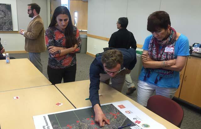
5 PREPARING FOR SEA LEVEL RISE Stakeholder Engagement & Public Outreach 5

6 SEA LEVEL RISE VULNERABILITY ASSESSMENT 6
7 VULNERABILITY ASSESSMENT STEPS Develop County-specific approach Gather data and categorize assets Inundation exposure analysis and mapping Vulnerability and risk analysis Initial adaptation planning ACTIONABLE OUTCOMES 7
8 ASSET CATEGORIZATION Assets were organized into classes based on: Public health, safety, welfare (built assets) Ranked by potential risk to life & safety (1 to 4) Ecosystem and habitat (natural assets) Social vulnerability (human assets) 8
9 ASSET CATEGORIZATION 9

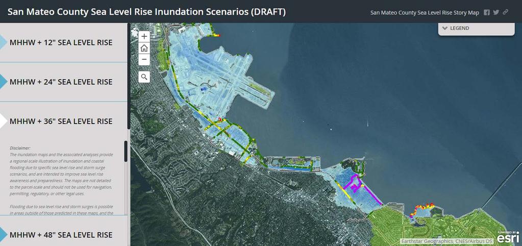
10 SEA LEVEL RISE MAPPING Redwood City Menlo Park 1% Annual Chance Storm 1% Chance Storm Feet SLR 1% Chance Storm Feet SLR East Palo Alto 10

11 DRAFT MAPS - COAST Princeton El Granada 1% Annual Chance Storm 1% Chance Storm Feet SLR 1% Chance Storm Feet SLR Future Erosion Zones Half Moon Bay 11
12 OVERTOPPING MAPS


 Case studies Linda Mar / Pacifica")
13 HABITAT & NATURAL RESOURCES Habitats Most Vulnerable to SLR Rocky Intertidal Estuaries Beaches San Mateo County SLR Vulnerability Assessment Evaluation of vulnerable habitats Fitzgerald Marine Preserve Pescadero Marsh (Phase II) Case studies Linda Mar / Pacifica State Beach 13

14 INVENTORY OF ASSETS AT RISK Developed for each city & unincorporated area: El Granada Harbor/Industrial Miramar Mobile Home Parks Montara Moss Beach North Fair Oaks Olympic Country Club Princeton SFO Unincorporated 14

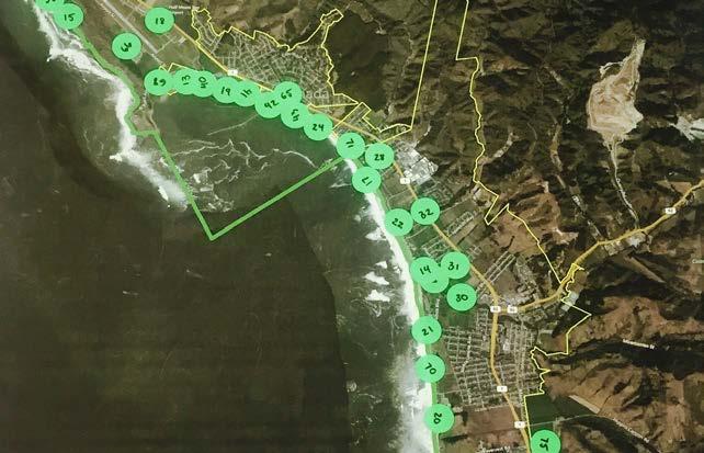
15 CASE STUDY ASSETS 15


16 CASE STUDIES NORTH COAST Pacifica Nursing & Rehab Facility Linda Mar, Pacifica Mussel Rock, Daly City Fitzgerald Marine Preserve Beach Boulevard, Pacifica 16

")


17 CASE STUDIES SOUTH COAST SAM Plant (wastewater) California Coastal Trail Closed Landfill Mirada Rd, Half Moon Bay Surfer s Beach/ Hwy 1 17

18 STAKEHOLDER INVOLVEMENT & OUTREACH Technical Working Group Policy Advisory Committee Community Task Force Public Outreach 18

19 YESS PROGRAM PILOT Students from Redwood High School presenting to San Mateo County Board of Supervisors 5/10/
20 NEXT STEPS Finalize Vulnerability Assessment (Fall) Begin South Coast Vulnerability Assessment (Summer) Launch Phase II (Fall) County sea level rise policy Adaptation planning Pilot projects 20

21 COASTAL PROJECTS Surfer s Beach Sand Placement Pilot Project (in scoping phase) 21


22 GENERAL PLAN/LCP UPDATES Half Moon Bay (includes SLR vulnerability assessment) 22

23 QUESTIONS? CONTACT: Hilary Papendick Climate Resiliency Specialist Linda Mar/ Pacifica State Beach, Photo by H Papendick 23

24 AVAILABLE ADAPTATION MEASURES Levees and the National Flood Insurance Program: Improving Policies and Practices (2013)
25 PROJECT OVERVIEW Task Jun- Aug Sep- Nov Dec - Feb Mar- May Jun- Aug Sep- Oct Develop Approach/ Convene Stakeholder groups x Data Gathering x Sea Level Rise Mapping & Exposure Analysis Vulnerability & Risk Analysis / Asset Profiles x x Adaptation Strategies x Draft Report x Final Report x x = Stakeholder Meeting 25

26 DRAFT MAPS - COAST Daly City Sharp Park, Pacifica 1% Annual Chance Storm 1% Chance Storm Feet SLR 1% Chance Storm Feet SLR Future Erosion Zones Linda Mar, Pacifica 26

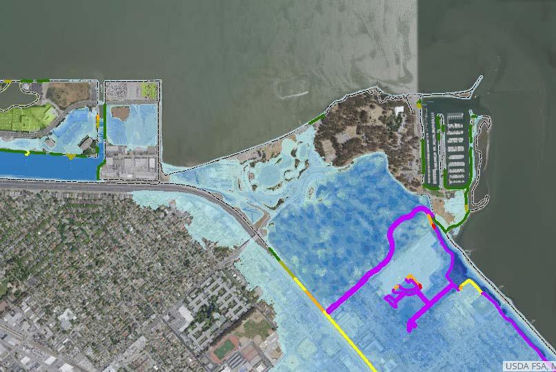
27 DRAFT MAPS CENTRAL BAY SFO San Mateo 1% Annual Chance Storm 1% Chance Storm Feet SLR 1% Chance Storm Feet SLR Future Erosion Zones Foster City 27

28 DRAFT MAPS NORTH BAY Brisbane South San Francisco 1% Annual Chance Storm 1% Chance Storm Feet SLR 1% Chance Storm Feet SLR Future Erosion Zones SFO 28
City of Del Mar Local Coastal Plan (LCP) Amendment for Sea Level Rise and Coastal Flooding
 Amendment for Sea Level Rise and Coastal Flooding") City of Del Mar Local Coastal Plan (LCP) Amendment for Sea Level Rise and Coastal Flooding 6/22/17 Presentation to Sea Level Rise Stakeholder- Technical Advisory Committee (STAC) Nick Garrity, P.E. Lindsey
City of Del Mar Local Coastal Plan (LCP) Amendment for Sea Level Rise and Coastal Flooding 6/22/17 Presentation to Sea Level Rise Stakeholder- Technical Advisory Committee (STAC) Nick Garrity, P.E. Lindsey
Leaning Into Adaptation
 www.marinslr.org Leaning Into Adaptation GFNMS Ocean Summit, May 17, 2016 Jack Liebster, Planning Manager, Marin County Marin County C-SMART Sea Level Rise Adaptation Process Evaluate Science Info. Implement
Coastal Hazards Study
 Coastal Hazards Study 2212 Beach Boulevard, Pacifica Prepared for: EXECUTIVE SUMMARY City of Pacifica 170 Santa Maria Ave Pacifica, CA 94044 Prepared by: moffatt & nichol 2185 N. California Blvd. Walnut
Collaboration: Sea-level Marin Adaptation Response Team (C-SMART)
") Collaboration: Sea-level Marin Adaptation Response Team (C-SMART) Photo Credit : Lighthawk Aerial Community Development Agency 3501 Civic Center Drive, Rm. 308 San Rafael, CA 94903 415 4736269 T www.marinslr.org
Collaboration: Sea-level Marin Adaptation Response Team (C-SMART) Photo Credit : Lighthawk Aerial Community Development Agency 3501 Civic Center Drive, Rm. 308 San Rafael, CA 94903 415 4736269 T www.marinslr.org
VENICE LOCAL COASTAL PROGRAM UPDATE: COASTAL HAZARDS WELCOME
 VENICE LOCAL COASTAL PROGRAM UPDATE: COASTAL HAZARDS WELCOME 1 Introducing the Team Hosted by the Department of City Planning and grant funded in part by the California Coastal Commission 2 Workshop Purpose
801 FASSLER AVENUE PACIFICA, CA
 801 FASSLER AVENUE PACIFICA, CA PROJECT SUMMARY This prime development opportunity in Pacifica, California consists of 11 picturesque acres showcasing dramatic Pacific Ocean views. The planned development
Ventura County. Open Pacific Coast Study. California Coastal Analysis and Mapping Project
 Ventura County Open Pacific Coast Study California Coastal Analysis and Mapping Project December 2011 Project Name: Meeting: Date and Time: Location: California Coastal Analysis and Mapping Project (CCAMP)/Open
COUNTY OF SAN MATEO Parks Department
 Agenda Item 5.B COUNTY OF SAN MATEO Parks Department DATE: March 16, 2015 COMMISSION MEETING DATE: April 9, 2015 TO: FROM: Parks and Recreation Commission Cecily Harris, Development Consultant SUBJECT:
ADAPTATION TO SEA LEVEL RISE AND COASTAL IMPACTS
 ADAPTATION TO SEA LEVEL RISE AND COASTAL IMPACTS Miramar Inn, Half Moon Bay, March 1, 2014 Photo by Jack Sutton, all rights reserved 2/22/17 AdaptLA Workshop California Coastal Commission 2 Plans and regulates
Bob Battalio, PE Chief Engineer, ESA September 8, 2016
 RELATING FUTURE COASTAL CONDITIONS TO EXISTING FEMA FLOOD HAZARD MAPS Technical Methods Manual Bob Battalio, PE Chief Engineer, ESA September 8, 2016 FMA 2016 Sacramento, California DWR-OST-SIO PILOTING
APPENDIX D-2. Sea Level Rise Technical Memo
 APPENDIX D-2 Sea Level Rise Technical Memo 2185 N. California Blvd., Suite 500 Walnut Creek, CA 94596 (925) 944-5411 Fax: (925) 944-4732 www.moffattnichol.com DRAFT MEMORANDUM To: From: Neil Nichols,
FEMA West Coast Sea Level Rise Pilot Study
 FEMA West Coast Sea Level Rise Pilot Study Ed Curtis, P.E., CFM FEMA Region IX June 4, 2014 Presentation Objectives Present the goals of the FEMA West Coast Sea Level Rise Pilot Study Review the SLR Pilot
DELAWARE S VULNERABLE COASTAL AREAS. DELAWARE INLAND BAYS and DELAWARE BAY RECONNAISSANCE STUDY
 DELAWARE S VULNERABLE COASTAL AREAS and the DELAWARE INLAND BAYS and DELAWARE BAY RECONNAISSANCE STUDY Kimberly K. McKenna, PG Delaware Dept. of Natural Resources & Environmental Control Division of Watershed
SR 693 (Pasadena Avenue) Corridor Study from Shore Drive South to 66 th Street
 Corridor Study from Shore Drive South to 66 th Street") Welcome and Introduction Sign-in and comment sheets Restrooms and exits Meeting agenda and timeline Meeting goals / expectations Provide input to guide study recommendations Actively participate throughout
Welcome and Introduction Sign-in and comment sheets Restrooms and exits Meeting agenda and timeline Meeting goals / expectations Provide input to guide study recommendations Actively participate throughout
Future Condi,ons coastal hazard modeling and mapping
 Future Condi,ons coastal hazard modeling and mapping Presented by Bob Ba:alio, PE Environmental Science Associates, Inc. (ESA) On behalf of the physical processes team (USGS, TerraCosta- Scripps, ESA)
SUPPLEMENTAL DOCUMENT SEA LEVEL RISE SCENARIO SELECTION AND DESIGN TIDE CALCULATION
 SUPPLEMENTAL DOCUMENT SEA LEVEL RISE SCENARIO SELECTION AND DESIGN TIDE CALCULATION FOR THE GUIDANCE FOR INCORPORATING SEA LEVEL RISE INTO CAPITAL PLANNING IN SAN FRANCISCO: ASSESSING VULNERABILITY AND
COMPARISON OF FIXED & VARIABLE RATES (25 YEARS) CHARTERED BANK ADMINISTERED INTEREST RATES - PRIME BUSINESS*
 CHARTERED BANK ADMINISTERED INTEREST RATES - PRIME BUSINESS*") COMPARISON OF FIXED & VARIABLE RATES (25 YEARS) Fixed Rates Variable Rates FIXED RATES OF THE PAST 25 YEARS AVERAGE RESIDENTIAL MORTGAGE LENDING RATE - 5 YEAR* (Per cent) Year Jan Feb Mar Apr May Jun Jul
COMPARISON OF FIXED & VARIABLE RATES (25 YEARS) Fixed Rates Variable Rates FIXED RATES OF THE PAST 25 YEARS AVERAGE RESIDENTIAL MORTGAGE LENDING RATE - 5 YEAR* (Per cent) Year Jan Feb Mar Apr May Jun Jul
LOCAL COASTAL PROGRAM UPDATE
 LOCAL COASTAL PROGRAM UPDATE Agenda Meeting #1 General Information (1 1:45 pm) Introductions and Background Grants involved What is a Local Coastal Program? What is required? LCP Update tasks and schedule
County of Santa Barbara Permit Option Analysis Goleta Beach JULY 13, 2017
 County of Santa Barbara Permit Option Analysis Goleta Beach JULY 13, 2017 Introduction 2 Goleta Beach Park welcomes 1.5 million visitors annually Amenities include: Picnic Areas and Group Areas w/bbqs
County of Orange Resources and Development Management Department Harbors, Beaches and Parks. Strategic Plan. HBP Strategic Plan Workshop 1.
 County of Orange Resources and Development Management Department Harbors, Beaches and Parks Strategic Plan HBP Strategic Plan Workshop 1 v18 PRESENTATION OUTLINE Harbors, Beaches & Parks (HBP) History
Get Us Moving Update. June 2018
 Get Us Moving Update June 2018 Community Engagement 2 Outreach by the Numbers $12 Billion in need identified through a call for projects process 7 Million Get Us Moving impressions on digital and social
El Niño: what it is and what to expect in San Francisco Bay
 El Niño: what it is and what to expect in San Francisco Bay A. O Neill U.S. Geological Survey Pacific Coastal and Marine Science Center Santa Cruz Outline Tropical Ocean and El Niño Impacts beyond the
101 Corridor Managed Lanes
 101 Corridor Managed Lanes TA BOD Meeting May 5, 2016 Agenda Item 11a Presentation Outline 101 Corridor Profile System Deficiencies Background Managed Lanes Proposed Purpose and Need Alternatives Under
Open Pacific Coast Study. California Coastal Analysis and Mapping Project
 Open Pacific Coast Study California Coastal Analysis and Mapping Project September 2012 California Open Coast Counties California Coastal Analysis and Mapping Project This publication is an initiative
HARBOR INFRASTRUCTURE INVENTORIES Marquette Harbor, Michigan
 HARBOR INFRASTRUCTURE INVENTORIES Marquette Harbor, Michigan Harbor Location: Marquette Harbor is located in Marquette Bay on the south shore of Lake Superior, 160 miles west of Sault Ste. Marie, MI and
STAFF REPORT C36 A 22 08/23/18 W S 13 A. Franzoia GENERAL LEASE OTHER
 STAFF REPORT C36 A 22 08/23/18 W 27060 S 13 A. Franzoia GENERAL LEASE OTHER APPLICANT: Association of Surfing Professionals, LLC (dba World Surf League) PROPOSED LEASE: AREA, LAND TYPE, AND LOCATION: 1,000
San Mateo County Comprehensive Bicycle and Pedestrian Plan Open House
 San Mateo County Comprehensive Bicycle and Pedestrian Plan Open House October 28, 2010 Presented to San Mateo County residents and interested parties by Lauren Ledbetter, Alta Planning + Design Matt Haynes,
SHOREHAM BEACH LOCAL NATURE RESERVE
 SHOREHAM BEACH LOCAL NATURE RESERVE Coastal Geography Education Programme 2014-15 S. Savage 2014 COASTAL GEOGRAPHY OPPORTUNITIES Shoreham Beach Shoreham Beach is a shingle spit formed over many centuries
How did you hear about this meeting?
 How did you hear about this meeting? Please stick a dot in each category that applies Radio or TV Postcard Email City Website Advertisement (Newspaper, internet) Other (Facebook, word of mouth, etc.) Future
Christina J. Slager Director of Animal Care and Exhibits. Aquarium of the Bay Pier 39, Embarcadero at Beach St. San Francisco, CA
 Christina J. Slager Director of Animal Care and Exhibits Aquarium of the Bay Pier 39, Embarcadero at Beach St. San Francisco, CA Sevengills on display at Aquarium of the Bay The Aquarium of the Bay strongly
SAN MATEO COUNTY TRANSIT DISTRICT 1250 SAN CARLOS AVENUE, SAN CARLOS, CALIFORNIA CITIZENS ADVISORY COMMITTEE MINUTES OF MEETING JULY 30, 2014
 SAN MATEO COUNTY TRANSIT DISTRICT 1250 SAN CARLOS AVENUE, SAN CARLOS, CALIFORNIA CITIZENS ADVISORY COMMITTEE MINUTES OF MEETING JULY 30, 2014 COMMITTEE MEMBERS PRESENT: N. Ballator, K. Gilbert, B. Gomez,
For Lease. 940 Old County Rd. Belmont, CA DO NOT DISTURB TENANT. New listing ±2,750 SF. Available now. Flexible lease terms. Extensive glass line
 940 Old County Rd Belmont, CA New listing ±2,750 SF Available now Flexible lease terms Extensive glass line New furniture could be made available Completely remodeled interior and exterior Large conference
San Mateo County Comprehensive Bicycle and Pedestrian Plan
 San Mateo County Comprehensive Bicycle and Pedestrian Plan August 26, 2010 Presented to the San Mateo County BPAC by Lauren Ledbetter, Alta Planning + Design in association with: Fehr & Peers Eisen Letunic
Unit 11 Lesson 2 How Does Ocean Water Move? Copyright Houghton Mifflin Harcourt Publishing Company
 Unit 11 Lesson 2 How Does Ocean Water Move? Catch a Wave A wave is the up-and-down movement of surface water. Catch a Wave Catch a Wave (wave effects) Surface waves are caused by wind pushing against
Wisconsin 511 Traveler Information Annual Usage Summary January 3, Wisconsin 511 Phone Usage ( )
") Wisconsin 511 Traveler Information 211 Annual Usage Summary January 3, 212 Overall to-date Summary 36 months of operation 1,16,63 total calls the 1 Million mark was passed on December 3, 212 3,627,527
Wisconsin 511 Traveler Information 211 Annual Usage Summary January 3, 212 Overall to-date Summary 36 months of operation 1,16,63 total calls the 1 Million mark was passed on December 3, 212 3,627,527
San Mateo County Bicycle and Pedestrian Advisory Committee
 San Mateo County Bicycle and Pedestrian Advisory Committee January 19, 2017 Emma Shlaes, Policy Manager About SVBC Mission Our purpose is to create a healthy community, environment, and economy through
Rhode Island Moving Forward Long-Range Transportation Plan 2040 Municipal Roundtable Newport County
 Rhode Island Moving Forward Long-Range Transportation Plan 2040 Municipal Roundtable Newport County www.planri.com PlanRI2040@gmail.com Municipal Roundtable Meeting Summary Date/time: Location: Wednesday,
Rhode Island Moving Forward Long-Range Transportation Plan 2040 Municipal Roundtable Providence County
 Rhode Island Moving Forward Long-Range Transportation Plan 2040 Municipal Roundtable Providence County www.planri.com PlanRI2040@gmail.com Municipal Roundtable Meeting Summary Date/time: Location: Tuesday,
 Time of Change We Are Growing We Are An Attractive Place To Live We Are Age Diverse + Living Longer 50000 40000 30000 20000 10000 0 2010 Census Job Density Housing Sheds Transit Sheds The Project FUNDING
2018 HR & PAYROLL Deadlines
 th (by payment date) EPAF 3rd PARTY FEEDS WTE Approval 2018 HR & PAYROLL s Normal Payroll day s 2017 B1-26 3 * 13-Dec-17 15-Dec-17 n/a n/a n/a 28-Dec-17 29-Dec-17 11:00 AM 16-Dec-2017 29-Dec-2017 JAN 2018
Atlantic Coast of Long Island, Jones Inlet to East Rockaway Inlet, Long Beach Island, NY Construction Update
 Atlantic Coast of Long Island, Jones Inlet to East Rockaway Inlet, Long Beach Island, NY Construction Update June 2016 US Army Corps of Engineers Project Purpose Three specific damage mechanisms of coastal
Utility Debt Securitization Authority 2013 T/TE Billed Revenues Tracking Report
 Utility Debt Securitization Authority 2013 T/TE Billed Revenues Tracking Report Billing Budgeted Billed Dollar Percent Month Revenues Revenues Variance Variance Jan 2018 11,943,180.68 12,697,662.47 754,481.79
Coastal Environments Oceanographic and Engineering Expertise
 Coastal Environments Oceanographic and Engineering Expertise Coastal Environments La Jolla, CA www.coastalenvironments.com 14 May 2004 CE Ref. No. 04-05 EcoSystems Management Associates, Inc. Carlsbad,
Sea Level Rise and Coastal Flooding Why Waves Matter!
 Sea Level Rise and Coastal Flooding Why Waves Matter! Jason D. Burtner Massachusetts Office of Coastal Zone Management South Shore Regional Coordinator Sea Level Rise and Coastal Storm Damage and Flooding
Purple Sea Urchin Barrens
 Purple Sea Urchin Barrens Nancy, Cassie and Jessica Pattern Sea Urchins existing in two stable states. Crevices along coastlines feeding on kelp litter that drifts by Emerged from the crevices creating
Report on Science Center Activities
 Agenda Item E.1.b Supp NMFS PowerPoint March 2016 Report on Science Center Activities Columbia River Estuary Habitat Puget Sound Harbor Seal Predation West Coast Salmon GSI Climate Update Evaluating the
The Local Coastal Plan Workshop #1: Santa Monica s Coastal Area in the 21 st Century
 The Local Coastal Plan Workshop #1: Santa Monica s Coastal Area in the 21 st Century Civic Auditorium, East Wing Monday, February 29, 2016 6:30pm 8:30pm Approximately 60 residents and stakeholders from
Response of a Newly Created Marsh-Wetland Affected by Tidal Forcing, Upland Discharge, and Groundwater Interaction
 Response of a Newly Created Marsh-Wetland Affected by Tidal Forcing, Upland Discharge, and Groundwater Interaction Mouth of Columbia River, Cape Disappointment State Park, Washington 12 Hans R. Moritz
BICYCLE TOURISM: IDEAS FOR BEST PRACTICE
 BICYCLE TOURISM: IDEAS FOR BEST PRACTICE Agenda Overview Understanding the Cycling Industry California Cycling Community Action for Best Practice Cycle California Coast Questions Overview Why Cycling Tourism?
COASTAL EROSION. 1 Getting Oriented
 COASTAL EROSION Many people dream of building their home on the California Coastline with its picturesque vistas of the setting sun and the gentle sounds of waves breaking. However, these waves are not
Org Chart. Steering. Committee. Project Advisory. Committee. Nicole Losch, PTP Senior Transportation. Bryan Davis, AICP Senior Transportation
 1 Org Chart Project Advisory Committee Steering Committee Nicole Losch, PTP Senior Transportation Planner Bryan Davis, AICP Senior Transportation Planner Jonathan Slason, PE Project Manager Diane Meyerhoff
Coastal Hazards and Management in North Carolina. Braxton Davis April 14, 2015
 Coastal Hazards and Management in North Carolina Braxton Davis April 14, 2015 Coastal Facts and Figures 320 miles of ocean beaches 12,000+ miles of estuarine shoreline 2 million + acres of sounds, creeks,
Bike San Mateo County San Mateo County Bicycle Plan Recommendations August 30, 2010
 Policy and Procedures Develop and Implement a Complete Streets Policy to comply with DD-64-R1 and AB1358 Commencing January 1, 2011, AB1358 requires that the legislative body of a city or county, upon
Welcome! Did You Know...? Aquatic Centre Dock Rebuild. Key Objectives
 1 Welcome! Aquatic Centre Dock Rebuild The City of Vancouver is improving the dock at the Vancouver Aquatic Centre, which is nearing the end of its service life and is in need of replacement. This creates
Preliminary Design of Wayzata Boulevard Improvements(CSAH 112)
") Project Area Map 6 COUNTY 112 COUNTY Preliminary Design of Wayzata Boulevard Improvements(CSAH 112) Public Open House Open House To Do List: Sign in Visit with Hennepin County staff and design team Learn
Project Area Map 6 COUNTY 112 COUNTY Preliminary Design of Wayzata Boulevard Improvements(CSAH 112) Public Open House Open House To Do List: Sign in Visit with Hennepin County staff and design team Learn
4/20/17. #31 - Coastal Erosion. Coastal Erosion - Overview
 Writing Assignment Due Monday by 11:59 pm #31 - Coastal Erosion Beach front property! Great View! Buy now at a great price! See main class web pages for detailed instructions Essays will be submitted in
Town of Duck, North Carolina
 Tracking No. 00.00.2010 Erosion Mitigation And Shoreline Management Feasibility Study Town of Duck, North Carolina Coastal Planning & Engineering of North Carolina August 15, 2012 Tom Jarrett Robert Neal
Citrus, Hernando, and Pasco Coastal Hazard Analysis. Flood Risk Review Meeting Citrus, Hernando, and Pasco Counties, Florida December 14, 2017
 Citrus, Hernando, and Pasco Coastal Hazard Analysis Flood Risk Review Meeting Citrus, Hernando, and Pasco Counties, Florida December 14, 2017 Introductions Risk MAP Project Team FEMA Region IV RAMPP (study
Balance in the Bay. An introduction to ecosystem-based management and the Monterey Bay market squid fishery.
 Balance in the Bay An introduction to ecosystem-based management and the Monterey Bay market squid fishery. Original Artwork Ray Troll & NOAA/2008 Fisheries Management Sustaining the greatest number of
Survey of Surfing at Seaside Reef
 Survey of Surfing at Seaside Reef (continued from 1st survey page) *** = required field 1. Why did you choose to surf at Seaside Reef today? (Please rank their importance) A. This spot has better surf
2013 FEDERAL STORM RESPONSE
 2013 FEDERAL STORM Presented to the Florida Shore & Beach Association Sep 26, 2013 Presented by: COL Alan Dodd Commander, Jacksonville District September 2013 THE COLLABORATION 2 THE PROGRAM 3 THE STORMS
AN OVERVIEW OF RECENT PROJECTS RELATED TO SAND BUDGETS, SOUTHERN CALIFORNIA BEACHES
 AN OVERVIEW OF RECENT PROJECTS RELATED TO SAND BUDGETS, SAND SUPPLY, COASTAL ARMORING, MANAGEMENT, AND VALUING SOUTHERN CALIFORNIA BEACHES Dr. Kiki Patsch California State University Channel Islands Environmental
Stakeholder Update. Agenda. Project update Needs Identification Strategy Proposed needs Safety Collectors/Arterials Greenways Local roads
 1 Stakeholder Update May 21, 2018 2 Agenda Project update Needs Identification Strategy Proposed needs Safety Collectors/Arterials Greenways Local roads Proposed Evaluation Criteria Next Steps 1 Project/Schedule
CLIMATE ACTION PLAN PROGRESS UPDATE. Climate Action Program APRIL, 2018
 CLIMATE ACTION PLAN PROGRESS UPDATE Climate Action Program APRIL, 2018 CLIMATE ACTION PLAN AT A GLANCE 12 MILESTONES 13 INDICATORS/ TARGETS 254 ACTIONS KEY CLIMATE ACTION PLAN IMPLEMENTERS Department Heads
S E SKELLY ENGINEERING
 May 5, 2004 Mr. Joel Baldwin Earth Investigation Consultants P.O. Box 795 Pacifica, CA 94044 SUBJECT: Reference: Coastal Hazard Study Proposed Legacy Quest Condominiums, 1567 Beach Boulevard, Pacifica.
Financial Project ID No(s).: and ETDM No(s).: and 14181
.: and ETDM No(s).: and 14181") Palm Beach Metropolitan Planning Organization (MPO) Presentation I-95 at Boynton Beach Boulevard Interchange and I-95 at Gateway Boulevard Interchange Project Development and Environment Study Palm Beach
Palm Beach Metropolitan Planning Organization (MPO) Presentation I-95 at Boynton Beach Boulevard Interchange and I-95 at Gateway Boulevard Interchange Project Development and Environment Study Palm Beach
BIKE AND RIDE ACCESS AND IMPLEMENTATION PLAN
 BIKE AND RIDE ACCESS AND IMPLEMENTATION PLAN Linking the region s expanding bicycle networks to transit infrastructure, implementing a prioritized set of projects that will provide attractive, safe, healthy,
FEMA Region V. Great Lakes Coastal Flood Study. Pilot Study Webinar. Berrien County, Michigan. February 26, 2014
 FEMA Region V Great Lakes Coastal Flood Study Pilot Study Webinar Berrien County, Michigan February 26, 2014 2 Pilot Study Webinar Agenda Great Lakes Coastal Flood Study Background Demonstration Project
Orange County MPA Watch A n n u a l R e p o r t
 Orange County MPA Watch 2 0 1 4 A n n u a l R e p o r t WHAT IS AN MPA? Marine Protected Areas (MPAs) are discrete geographic marine or estuarine areas designed to protect or conserve marine life and habitat.
Staff Report City of Manhattan Beach
 Agenda Item #: Staff Report City of Manhattan Beach TO: Honorable Mayor Montgomery and Members of the City Council THROUGH: Richard Thompson, Interim City Manager FROM: Sona Kalapura, Environmental Programs
Freeway ramp intersection study
 Freeway ramp intersection study Supporting Vision Zero: Zero traffic deaths in San Francisco by 2024 Study Goals: Primary Improve Safety Improve Accessibility Secondary Provide Efficient Circulation Accommodate
2020 & 2024 LCR Study Draft Results Greater Bay Area
 2020 & 2024 LCR Study Draft Results Greater Bay Area Binaya Shrestha Regional Transmission Engineer Lead Stakeholder Meeting March 14, 2019 Greater Bay Area Transmission System & LCR Subareas Contra Costa
PLANNING TO KEEP WELLFLEET SPECIAL
 PLANNING TO KEEP WELLFLEET SPECIAL HEATHER MCELROY Wellfleet Conservation Trust Annual Meeting : August 18, 2018 Mission of the Cape Cod Commission To protect the unique values and quality of life on Cape
MEETING JUST YOUR OVERVIEW
 JUST YOUR MEETING Some meetings simply require more focus and fewer distractions. When you hold your meeting at Seal Cove Inn, the entire ten-room hotel is yours. Without other hotel guests at the inn,
Adaptation to climate variation in a diversified fishery:
 Adaptation to climate variation in a diversified fishery: The West Coast groundfish trawl fishery Lisa Pfeiffer Northwest Fisheries Science Center, NOAA Fisheries Seattle, Washington USA The West Coast
Transportation & Land Use. Workshop: March 6, 2013
 Marpole Community Plan Transportation & Land Use Workshop: March 6, 2013 Overview 1 Community Plan 2 Transportation 2040 & Community Plans 3 4 Overview 1 Community Plan 2 Transportation 2040 & Community
Nearshore Waves and Erosion Model Quantifying the Coastal Protection Benefits Provided by Natural Habitats
 Nearshore Waves and Erosion Model Quantifying the Coastal Protection Benefits Provided by Natural Habitats SaveGuanaCayReef Marinehindsight.com Necessary to quantify protection services offered by natural
california SUMMER 2018
 SAN FRANCISCO, CALIFORNIA 37.7749 N, 122.4194 W california trip overview The Golden State offers the perfect playground for the aspiring adventurer, and our California trip takes you to most beautiful
Name Class Date. Use the terms from the following list to complete the sentences below. Each term may be used only once. Some terms may not be used.
 Assessment Chapter Test B The Movement of Ocean Water USING KEY TERMS Use the terms from the following list to complete the sentences below. Each term may be used only once. Some terms may not be used.
STAFF REPORT. MEETING DATE: May 21, 2015 AGENDA ITEM: 7F
 STAFF REPORT SUBJECT: Assembly Concurrent Resolution 58 MEETING DATE: May 21, 2015 AGENDA ITEM: 7F STAFF CONTACT: Kent Epperson RECOMMENDATION: Authorize the chair to send a letter supporting ACR 58 (Williams)
Managing and Adapting to Sea Level Rise in Egypt. Coastal Research Institute
 Managing and Adapting to Sea Level Rise in Egypt Coastal Research Institute Global Perspective Climate-induced increases in sea level are caused by thermal expansion of the oceans and melting of land ice
The Blob, El Niño, La Niñas, and North Pacific marine ecosystems
 The Blob, El Niño, La Niñas, and North Pacific marine ecosystems Laurie Weitkamp Northwest Fisheries Science Center Newport Field Station NOAA Fisheries Laurie.weitkamp@noaa.gov Bill Peterson s Big Picture:
Boothbay Harbor Rotary Club May 12, 2016
 Mapping Potential Sea Level Rise and Storm Surge in Boothbay Harbor, ME Boothbay Harbor Rotary Club May 12, 2016 Peter A. Slovinsky, Marine Geologist Maine Geological Survey S.M. Dickson, MGS Quickly,
Quantifying the Value of Sydney s Beaches
 Quantifying the Value of Sydney s Beaches Dave Anning Economics, Management & the Coastal Zone Forum 24 February 2011 Sydney Beaches Valuation Project Collaboration between UNSW and SCCG Value case study
AUTOMATED SPEED ENFORCEMENT: REDUCING SPEED TO SAVE LIVES
 Through Vision Zero SF we commit to working together to prioritize street safety and eliminate traffic deaths in San Francisco by 2024 AUTOMATED SPEED ENFORCEMENT: REDUCING SPEED TO SAVE LIVES INTRODUCING
Colorado Weather and Climate Update
 Colorado Weather and Climate Update Nolan J. Doesken State Climatologist Colorado Climate Center, Atmospheric Science Department, Colorado State University Presented to Colorado Livestock Association,
Estuary Care Foundation SA: community led restoration & climate adaptation
 Estuary Care Foundation SA: community led restoration & climate adaptation Presentation to SA Coastal Conference 9 th November 2017 Catherine McMahon, Estuary Care Foundation Port River and Barker Inlet
Sloat Blvd. Pedestrian Safety Improvement Project
 Sloat Blvd. Pedestrian Safety Improvement Project Department of Public Works Project team and background Budget Schedule Scope of work Sloat Blvd - Everglade Drive Sloat Blvd - Forest View Drive Sloat
Town of Duck, North Carolina
 Tracking No. 00.00.2010 Erosion Mitigation And Shoreline Management Feasibility Study Town of Duck, North Carolina Coastal Planning & Engineering of North Carolina February 28, 2013 Ken Willson 1 Tracking
SUBJECT Memorandum of Understanding to Complete a Caltrain Grade Separation Study for the Whipple Avenue Crossing
 REPORT To the Honorable Mayor and City Council From the City Manager October 1, 2018 SUBJECT Memorandum of Understanding to Complete a Caltrain Grade Separation Study for the Whipple Avenue Crossing RECOMMENDATION
Key Feature and Challenges from Climate Change for Mekong River Basin
 1 Key Feature and Challenges from Climate Change for Mekong River Basin By Dr. Thanapon Piman Planning Division Basin Development Plan Pragramme Mekong River Commission Secretariat (MRCS) 2 Outline 1)
City of Wilsonville 5 th Street to Kinsman Road Extension Project
 City of Wilsonville 5 th Street to Kinsman Road Walking Tour & Neighborhood Workshop Summary Report Public Outreach Overview On July 18 th, 2017, the City of Wilsonville hosted a neighborhood walking tour
CUSTOMER ADVISORY COMMITTEE
 CUSTOMER ADVISORY COMMITTEE January 25, 2017 TITLE VI This meeting, project, or study is being conducted without regard to race, color, national origin, age, sex, religion, disability or family status.
Encouraging Taxi Drivers to Behave: Grafton Bridge Taxi and Bus Lane Trial. Rob Douglas-Jones Tim Segedin, Edin Ltd.
 Encouraging Taxi Drivers to Behave: Grafton Bridge Taxi and Bus Lane Trial Rob Douglas-Jones Tim Segedin, Edin Ltd. 2.1km 12 mins Hospital 1.5km 9 mins To Newmarket 5 500 bikes per day 500 pedestrians
WATER WELL DRILLER AND PUMP INSTALLER LICENSING REPORT ADVISORY BOARD MEETING January 5, 2018
 WATER WELL DRILLER AND PUMP INSTALLER LICENSING REPORT ADVISORY BOARD MEETING January 5, 2018 Water Well Driller and Pump Installer FY 14 FY 15 FY 16 FY 17 1 st Quarter FY 18 New Licenses Issued 92 73
Sea-Level Rise and Coastal Habitats in Southeastern Louisiana An Application of the SLAMM Model
 Sea-Level Rise and Coastal Habitats in Southeastern Louisiana An Application of the SLAMM Model Patty Glick (National Wildlife Federation) Jonathan Clough (Warren Pinnacle Consulting, Inc.) Amy Polaczyk
September 2017 MLS Statistical Report. Residential Inventory
 September 217 MLS Statistical Report Residential Inventory 2 2 1 1 21 216 217 Summary Inventories: Residential inventory is down 1%, Lots / Land inventory is down 13% and commercial inventory was down
STATUS REPORT FOR THE SUBMERGED REEF BALL TM ARTIFICIAL REEF SUBMERGED BREAKWATER BEACH STABILIZATION PROJECT FOR THE GRAND CAYMAN MARRIOTT HOTEL
 August 23 STATUS REPORT FOR THE SUBMERGED REEF BALL TM ARTIFICIAL REEF SUBMERGED BREAKWATER BEACH STABILIZATION PROJECT FOR THE GRAND CAYMAN MARRIOTT HOTEL performed by Lee E. Harris, Ph.D., P.E. Consulting
Some Steps Towards Climate-Ready Management of U.S. Fisheries
 Some Steps Towards Climate-Ready Management of U.S. Fisheries Roger Griffis 1, Wendy Morrison 1, Mark Nelson 1, Jon Hare 2, Valerie Termini 3 1 NOAA National Marine Fisheries Service, Silver Spring, MD,
I certify that the information contained in the following pages is correct to the best of my knowledge.
 CERTIFICATION Specific dates of summary: July 1, 2017 June 30, 2018 I certify that the information contained in the following pages is correct to the best of my knowledge. PREPARED BY: DATE: August 15,