Jeff Deems Western Water Assessment National Snow and Ice Data Center University of Colorado. Tom Painter NASA Jet Propulsion Laboratory
|
|
|
- Lambert Randall
- 5 years ago
- Views:
Transcription

1 Jeff Deems Western Water Assessment National Snow and Ice Data Center University of Colorado Tom Painter NASA Jet Propulsion Laboratory and the ASO Team


2 The NASA JPL Airborne Snow Observatory Snow Water Equivalent Riegl Q1560 ALS 800 khz Pulse Rate 2 lasers with fore/ar poineng Snow Albedo CASI Imaging Spectrometer μm 2m spaeal resolueon from 4000m aso.jpl.nasa.gov Retrieve topography: snow- free & snow- on Difference gives snow depth SWE from assimilaeon of modeled density field constrained by observaeons SWE variaeon primarily due to depth


3 Snow depth & SWE from LiDAR majority of spaeal variability in SWE is due to snow depth depth can be measured by differeneal elevaeon mapping collect snow- free & snow- covered data sets classify & remove vegetaeon subtract snow- free from snow- covered apply obs/modeled density SWE = depth * density SNOTEL/manual obs + snow model can esemate density well SNOWPACK model, courtesy CAIC LiDAR- derived snow depth, Colorado (Deems et al., 2013)


4 Snow Albedo from Hyperspectral Imagery Visible Near IR Reflectance Wavelength (μm)


5 Riegl Q1560 ALS Twin lasers Long range 5000m+ AGL Fore/aR poineng enhances coverage & geometry in steep terrain Wide FOV allows large overlap or efficient planning Full waveform processing improves subcanopy surface deteceon

6 ASO Compute System opera1onal products 24- hour data product latency products: snow depth SWE (using snow pillow + modeled densiees) broadband albedo LiDAR/spectrometer workflows are interdependent LiDAR DSM used for terrain correceon spectrally snow- free areas forced to zero snow depth


7 ASO DemonstraEon Missions /14/15 2 Primary study basins: Tuolumne River, Yosemite National Park, CA Uncompahgre River, CO Snow- off August, 2012 Snow- on Spring weekly flights in CA monthly flights in CO

8 Example Results: 2014 & 2015 Tuolumne Basin, CA Yosemite NaMonal Park h"p://wwa.colorado.edu
9 Tuolumne River Basin SWE aso.jpl.nasa.gov
10 Tuolumne River Basin SWE aso.jpl.nasa.gov

11 Tuolumne River Basin SWE aso.jpl.nasa.gov
12 Tuolumne River Basin SWE aso.jpl.nasa.gov
13 Tuolumne River Basin SWE aso.jpl.nasa.gov
14 Tuolumne River Basin SWE aso.jpl.nasa.gov
15 Tuolumne River Basin SWE aso.jpl.nasa.gov
16 Tuolumne River Basin SWE aso.jpl.nasa.gov
17 Tuolumne River Basin SWE aso.jpl.nasa.gov
18 Tuolumne River Basin SWE aso.jpl.nasa.gov
19 Tuolumne River Basin SWE aso.jpl.nasa.gov

20 Tuolumne River Basin SWE Tioga Pass, CA 16 April 2015
21 Tuolumne River Basin SWE aso.jpl.nasa.gov
22 Tuolumne River Basin SWE aso.jpl.nasa.gov
23 Tuolumne River Basin SWE aso.jpl.nasa.gov
24 Tuolumne River Basin SWE aso.jpl.nasa.gov
25 Tuolumne River Basin SWE aso.jpl.nasa.gov
26 Tuolumne River Basin SWE aso.jpl.nasa.gov
27 Tuolumne Basin SWE & Reservoir Inflow

28 Banded SWE Report Uncompahgre River above Ridgway, 30 April 2015

29 ApplicaEons IntegraMng ASO with water management


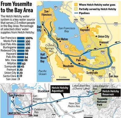


30 Hetch Hetchy Reservoir OperaEons balancing streamflow, water supply, & hydropower needs


31 Tuolumne Basin Hydrology Modeling SWE/Met StaMons & PRMS Model Units h"p://wwa.colorado.edu ASO SWE & Albedo aggregated to PRMS hydrologic response units
32 Tuolumne Basin Hydrology Modeling Results: 2014 h"p://wwa.colorado.edu Courtesy Bruce McGurk McGurk Hydrologic

 High resolueon land cover classificaeon Snow")
33 Current ASO products LiDAR High resolueon DEM & DSM Tree/canopy height maps Terrain morphology Water body mask Surface roughness Snow depth SWE SCA and SC% ElevaEon band SWE map & report SWE Eme series Snowline esemaeon Spectrometer Land surface albedo High resolueon imagery (RGB) High resolueon land cover classificaeon Snow albedo


34 SWE & SCA Reports IntegraEon with exiseng data needs Banded SWE products Map & tabular Basin aggregate SWE & SCA


35 ASO Expansion: California State of CA & water manager support for full Sierra Nevada coverage
 Wyoming: (State Engineer s Office) Wyoming Range Wind River Range Sierra Madre Medicine")
36 ASO Expansion: Colorado River Basin Uncompahgre River Grand Mesa Rio Grande/Conejos R. (Colorado Water ConservaMon Board) Wyoming: (State Engineer s Office) Wyoming Range Wind River Range Sierra Madre Medicine Bow Mountains h"p://wwa.colorado.edu


#MASTER# #1#thermal#infrared#band,#a# proxy#for#nirops#(~#1#m#resoludon)#")
#NIROPS#progression#with#MODIS#")
#MASTER#mulDband#thermal#infrared#")
37 Megafire Disaster Response: NASA JPL and USDA Forest Service inter- agency collaboraeons ObjecEve: characterize pre, aceve and post- burn condieons of megafires, to observe ecosystem properees influencing fire probability, behavior and recovery as a basis for aiding management Coverage: California King (2014) and Rim (2013) megafires Data colleceon, processing and disseminaeon (wildfire.jpl.nasa.gov) is a collaboraeve effort that aids disaster response and post- fire recovery planning such as: IdenEfy endangered species habitat Water quality assessment Erosion assessment Removal of hazardous logs Timber harveseng A)#MASTER# #1#thermal#infrared#band,#a# proxy#for#nirops#(~#1#m#resoludon)# #used#in#acdve#fire#management# perimeter#mapping# AVIRIS hyperspectral improves burn area imaging over Rim Fire B)#NIROPS#progression#with#MODIS# muldlband#thermal#infrared#acdve# fire#pixels#(~#1000#m#resoludon)#can# be#used#to#calculate#fire#intensity# C)#MASTER#mulDband#thermal#infrared# (35#m#resoluDon)# LiDAR before (left) and after (right) King Fire Increasing#InformaDon#

38 New OpportuniEes in Water Management snow & weather paoerns are increasingly different from past years dust on snow climate warming new tools are becoming available to support resilient management of water resources expanded measurements of the snow energy balance airborne & satellite mapping of snow depth & albedo high resolueon weather forecasts integrated snowmelt & hydrology forecasts
39 Contact: Jeff Deems Tom Painter aso.jpl.nasa.gov
Jeff Deems Western Water Assessment National Snow and Ice Data Center University of Colorado. Tom Painter NASA Jet Propulsion Laboratory
 Jeff Deems Western Water Assessment National Snow and Ice Data Center University of Colorado Tom Painter NASA Jet Propulsion Laboratory and the ASO Team The NASA JPL Airborne Snow Observatory Snow Water
Real Time (RT) Snow Water Equivalent (SWE) Simulation April 14, 2014 Sierra Nevada Mountains, California
 Snow Water Equivalent (SWE) Simulation April 14, 2014 Sierra Nevada Mountains, California") Real Time (RT) Snow Water Equivalent (SWE) Simulation April 14, 2014 Sierra Nevada Mountains, California Abstract On April 14 th, percent of average SWE values for this date have decreased to 10% for the
Real Time (RT) Snow Water Equivalent (SWE) Simulation April 14, 2014 Sierra Nevada Mountains, California Abstract On April 14 th, percent of average SWE values for this date have decreased to 10% for the
Real Time (RT) Snow Water Equivalent (SWE) Simulation May 26, 2014 Sierra Nevada Mountains, California
 Snow Water Equivalent (SWE) Simulation May 26, 2014 Sierra Nevada Mountains, California") Real Time (RT) Snow Water Equivalent (SWE) Simulation May 26, 2014 Sierra Nevada Mountains, California Abstract On May 26 th, percent of average SWE values for this date have shown an increase to 0.5%
Real Time (RT) Snow Water Equivalent (SWE) Simulation May 26, 2014 Sierra Nevada Mountains, California Abstract On May 26 th, percent of average SWE values for this date have shown an increase to 0.5%
Real Time (RT) Snow Water Equivalent (SWE) Simulation February 25, 2014 Sierra Nevada Mountains, California
 Snow Water Equivalent (SWE) Simulation February 25, 2014 Sierra Nevada Mountains, California") Real Time (RT) Snow Water Equivalent (SWE) Simulation February 25, 2014 Sierra Nevada Mountains, California Abstract On February 25th, percent of average SWE values for this date are 8.15% for the Northern
Real Time (RT) Snow Water Equivalent (SWE) Simulation February 25, 2014 Sierra Nevada Mountains, California Abstract On February 25th, percent of average SWE values for this date are 8.15% for the Northern
PACIFIC NORTHWEST TEST OF A HYDROGRAPHIC AIRBORNE LASER SCANNER
 PACIFIC NORTHWEST TEST OF A HYDROGRAPHIC AIRBORNE LASER SCANNER Green LiDAR Workshop June 3 7, 2012 Russell Faux, Principal Watershed Sciences, Inc. 517 SW 2 nd Street, Suite 400 Corvallis, OR 97333 541
Climate Change and Hydrology in the Sierra Nevada. Lorrie Flint U.S. Geological Survey Sacramento CA
 Climate Change and Hydrology in the Sierra Nevada Lorrie Flint U.S. Geological Survey Sacramento CA Discussion Topics Climate change for California Methods to evaluate hydrologic impacts Water balance
TROUT CREEK WATERSHED (Second Year of Snowline Data)
") Extent of Snow Cover During the 2002 Spring Freshet For the TROUT CREEK WATERSHED (Second Year of Snowline Data) (Penticton Forest District) 1.0 INTRODUCTION The extent of snow cover over a watershed basin
Extent of Snow Cover During the 2002 Spring Freshet For the TROUT CREEK WATERSHED (Second Year of Snowline Data) (Penticton Forest District) 1.0 INTRODUCTION The extent of snow cover over a watershed basin
Small Footprint Topo-Bathymetric LiDAR
 May 8, 2013 Small Footprint Topo-Bathymetric LiDAR PNAMP Remote Sensing Forum Russ Faux, Co-CEO, WSI Amar Nayegandhi, Manager of Elevation Technologies, Dewberry Colin Cooper, Senior Analyst, WSI Watershed
Challenges in determining water surface in airborne LiDAR topobathymetry. Amar Nayegandhi, Dewberry 15 th Annual JALBTCX Workshop, June 11 th 2014
 Challenges in determining water surface in airborne LiDAR topobathymetry Amar Nayegandhi, Dewberry 15 th Annual JALBTCX Workshop, June 11 th 2014 Why topobathy LiDAR? Complements acoustic (multi-beam sonar)
Airborne Remote Sensing of Surface and Internal Wave Processes on the Inner Shelf
 Airborne Remote Sensing of Surface and Internal Wave Processes on the Inner Shelf Ken Melville, Luc Lenain Scripps Institution of Oceanography North Wind/Wave NDBC Station 42040 29.212 N 88.207 W 19 Oct
FISHERIES BLUE MOUNTAINS ADAPTATION PARTNERSHIP
 FISHERIES A warming climate, by itself, substantially affects the hydrology of watersheds in the Blue Mountains. Among the key hydrologic changes projected under all scenarios for the 2040s and beyond
Historical and Current Climate in the Rio Grande National Forest Area. Peter Goble Nolan Doesken 10/19/2016
 Historical and Current Climate in the Rio Grande National Forest Area Peter Goble Nolan Doesken 10/19/2016 Geographic Orientation Geographic Orientation Geographic Orientation Rio Grande National Forest
Wave-Phase-Resolved Air-Sea Interaction
 DISTRIBUTION STATEMENT A. Approved for public release; distribution is unlimited. Wave-Phase-Resolved Air-Sea Interaction W. Kendall Melville Scripps Institution of Oceanography (SIO) UC San Diego La Jolla,
University of Wisconsin SSEC Atmospheric SIPS and AHI/ABI Capabilities
 University of Wisconsin SSEC Atmospheric SIPS and AHI/ABI Capabilities Robert Holz 1, Min Oo 1, Liam Gumley 1, Steve Dutcher 1, Bruce Flynn 1, Greg Quinn 1, Andi Walther 2, Andy Heidinger 2, Jeremy Solbrig
CENTER FOR SUBSURFACE SENSING AND IMAGING SYSTEMS
 CENTER FOR SUBSURFACE SENSING AND IMAGING SYSTEMS S4: Coral Reef Monitoring Why Coral Reefs? Roy A. Armstrong UPRM CenSSIS Site Visit April 5, 2006 The Importance of Coral Reefs Coral reefs are highly
Tuesday, January 11, :11 AM (CST)
") Tuesday, January 11, 2011 11:11 AM (CST) -Assessment of current water conditions - Precipitation Forecast - Recommendations for Drought Monitor Upper Colorado Normal Precipitation Upper Colorado River
Tuesday, January 11, 2011 11:11 AM (CST) -Assessment of current water conditions - Precipitation Forecast - Recommendations for Drought Monitor Upper Colorado Normal Precipitation Upper Colorado River
P2.17 OBSERVATIONS OF STRONG MOUNTAIN WAVES IN THE LEE OF THE MEDICINE BOW MOUNTAINS OF SOUTHEAST WYOMING
 P2.17 OBSERVATIONS OF STRONG MOUNTAIN WAVES IN THE LEE OF THE MEDICINE BOW MOUNTAINS OF SOUTHEAST WYOMING Larry D. Oolman 1, Jeffrey R. French 1, Samuel Haimov 1, David Leon 1, and Vanda Grubišić 2 1 University
Climate change and the California golden trout
 Climate change and the California golden trout Kathleen R. Matthews US Forest Service Research Sierra Nevada Research Center Outline Golden trout background How climate change may impact CGT and their
Drought Situations and Management Policy in Vietnam
 Regional Workshop for Asia-Pacific Capacity Development to Support National Drought Management Policy Drought Situations and Management Policy in Vietnam Nguyen Van Tinh, Dang Thanh Mai Hanoi, May 2014
SWIFT. The Stratospheric Wind Interferometer for Transport Studies
 The Stratospheric Wind Interferometer for Transport Studies SWIFT I. McDade, C. Haley, J. Drummond, K. Strong, B. Solheim, T. Shepherd, Y. Rochon, and the SWIFT Team ESA What is SWIFT? SWIFT is the Stratospheric
An Atlas of Oceanic Internal Solitary Waves (February 2004) by Global Ocean Associates Prepared for Office of Naval Research Code 322 PO
 by Global Ocean Associates Prepared for Office of Naval Research Code 322 PO") Overview covers approximately 5500 km of coast between Western Sahara (22 o N, 17 o W) and Angola (5 o S, 12 o E) (Figure 1). The continental shelf in the region varies significantly in width. The region
Overview covers approximately 5500 km of coast between Western Sahara (22 o N, 17 o W) and Angola (5 o S, 12 o E) (Figure 1). The continental shelf in the region varies significantly in width. The region
California golden trout: can their warming streams handle cattle grazing and climate change?
 California golden trout: can their warming streams handle cattle grazing and climate change? Kathleen R. Matthews USDA Forest Service Research Conservation of Biodiversity Program Pacific Southwest Research
Central American Pacific Coast
 Overview The Pacific coast of Central America extends approximately 3700 km from central Mexico (20 o N, 106 o W) to the edge of South America (7 o N, 78 o W). A significant continental shelf exists from
An Atlas of Oceanic Internal Solitary Waves (February 2004) by Global Ocean Associates Prepared for Office of Naval Research Code 322 PO
 by Global Ocean Associates Prepared for Office of Naval Research Code 322 PO") Overview covers approximately 2200 km of coast from Kenya to the tip of Somalia (approximately 39 o E, 4 o S to 51 o E, 12 o N)(Figure 1). Internal wave activity has been observed in the area the near
Overview covers approximately 2200 km of coast from Kenya to the tip of Somalia (approximately 39 o E, 4 o S to 51 o E, 12 o N)(Figure 1). Internal wave activity has been observed in the area the near
National Weather Service
 National Weather Service The North American Monsoon Until the late 1970s, there was serious debate about whether a monsoon truly existed in North America. However, considerable research, which culminated
Of the Salmon and For the Salmon
 Of the Salmon and For the Salmon for millions of years the wild salmon has helped nourish the plant and animal life of the temperate rain forest. Born in the streams and rivers of the forest, the salmon
El Niño: what it is and what to expect in San Francisco Bay
 El Niño: what it is and what to expect in San Francisco Bay A. O Neill U.S. Geological Survey Pacific Coastal and Marine Science Center Santa Cruz Outline Tropical Ocean and El Niño Impacts beyond the
Boost Your Skills with On-Site Courses Tailored to Your Needs
 Boost Your Skills with On-Site Courses Tailored to Your Needs www.aticourses.com The Applied Technology Institute specializes in training programs for technical professionals. Our courses keep you current
Digital Elevation Models
 Digital Elevation Models National Elevation Dataset 14-Oct-14 GEO327G/386G, UT Austin 1 Data Sets US DEM series 7.5, 30, 1 o for conterminous US 7.5, 15 for Alaska US National Elevation Data (NED) GTOPO30
White-Tailed Deer Management FAQ
 December 6 th, 217 Ministry of Forests, Lands, Natural Resource Operations and Rural Development White-Tailed Deer Management FAQ What are current white-tailed deer management objectives in the Kootenay
NEVADA DEPARTMENT OF WILDLIFE STATEWIDE FISHERIES MANAGEMENT
 NEVADA DEPARTMENT OF WILDLIFE STATEWIDE FISHERIES MANAGEMENT FEDERAL AID JOB PROGRESS REPORTS F-20-48 2012 LAKE TAHOE WESTERN REGION Contents NEVADA DEPARTMENT OF WILDLIFE, FISHERIES DIVISION ANNUAL PROGRESS
Utilizing Vessel Based Mobile LiDAR & Bathymetry Survey Techniques for Survey of Four Southern California Breakwaters
 Utilizing Vessel Based Mobile LiDAR & Bathymetry Survey Techniques for Survey of Four Southern California Breakwaters Western Dredging Association: Pacific Chapter September 2012 Insert: Pipe Location
JIMAR PFRP ANNUAL REPORT FOR FY 2006
 JIMAR PFRP ANNUAL REPORT FOR FY 2006 P.I./Sponsor Name: Michael P. Seki and Jeffrey J. Polovina Project Proposal Title: Oceanographic Characterization of the American Samoa Longline Fishing Grounds for
Drought! When Do We Know It s Over?
 Drought! When Do We Know It s Over? Nolan J. Doesken Colorado Climate Center Colorado State University http://ccc.atmos.colostate.edu Presented at the 2004 Peak to Prairie Landscape Symposium, February
Medicine Bow Routt National Forest and Thunder Basin National Grassland; Routt. County; Colorado; Steamboat Ski Resort, Steamboat EIS
 This document is scheduled to be published in the Federal Register on 09/06/2016 and available online at http://federalregister.gov/a/2016-21236, and on FDsys.gov [3411-15-P] DEPARTMENT OF AGRICULTURE
ASAP Satellite-based tropopause fold and mountain wave detection and validation
 ASAP Satellite-based tropopause fold and mountain wave detection and validation Tony Wimmers, Kristopher M. Bedka, Wayne Feltz, Nathan Uhlenbrock Cooperative Institute for Meteorological Satellite Studies
Workshop Overview and Related Projects
 Workshop Overview and Related Projects Rebecca A. French, Ph.D. CIRCA Director of Community Engagement ConnecEcut Living Shorelines: Projects into PracEce Workshop November 20, 2017 Morning 10:15 11:00
Probing the subsurface ocean processes using ocean LIDARS
 Probing the subsurface ocean processes using ocean LIDARS Authors: Robert Arnone (1), Sergio Derada (1), Sherwin Ladner (1), and Charles Trees (2) (1) NRL, Oceanography Division, Stennis Space Center,
Sierra Nevada Bighorn Sheep Proposal
 Sierra Nevada Bighorn Sheep Proposal Emily Cline Background: The Sierra Nevada bighorn sheep population began being threatened as early as the 1850s with the arrival of gold miners to the Sierra Nevada
NEVADA DEPARTMENT OF WILDLIFE STATEWIDE FISHERIES MANAGEMENT
 NEVADA DEPARTMENT OF WILDLIFE STATEWIDE FISHERIES MANAGEMENT FEDERAL AID JOB PROGRESS REPORTS F-20-52 2016 Lake Tahoe Rainbow Trout Study WESTERN REGION NEVADA DEPARTMENT OF WILDLIFE, FISHERIES DIVISION
Drought: What is the Status?
 Drought: What is the Status? Nolan J. Doesken Colorado Climate Center Colorado State University http://ccc.atmos.colostate.edu Presented at 2005 Peak to Prairie Landscape Symposium, February 11, 2005,
Understanding the Impacts of Culvert Performance on Stream Health
 Understanding the Impacts of Culvert Performance on Stream Health Kristin Thomas Aquatic Ecologist Michigan Trout Unlimited Transportation and the Environment Conference 12/5/2018 Importance of adequately
Airborne Laser Bathymetry for Monitoring the German Baltic Sea Coast
 Airborne Laser Bathymetry for Monitoring the German Baltic Sea Coast J. NIEMEYER 1, T. KOGUT 1,2 & C. HEIPKE 1 ABSTRACT: Periodic monitoring of the sea bed is one of the most important tasks of the public
Gerald H. Grondin Oregon Water Resources Department Groundwater Hydrology Section Salem, Oregon. Lost River Groundwater Surface Water Management
 Geologic Framework Influence On Managing Groundwater Interference With Surface Water, A Lost River Sub-Basin Example, Upper Klamath River Basin, Oregon Gerald H. Grondin Oregon Water Resources Department
LiDAR My favourite tool in the bag 2011 St Kitts & Nevis
 LiDAR My favourite tool in the bag 2011 St Kitts & Nevis Lt Cdr Rupert Forester-Bennett RN (ret d) December 5 th to 11 th 2011 Content Collection of geospatial data reasons Overcoming the White Ribbon
ATV/ARGO Trails for Red Indian Lake Outfitting
 ATV/ARGO Trails for Red Indian Lake Outfitting Proponent: Name: Red Indian Lake Outfitting Contact: Fred or Shirley Thorne Address: P.O. Box 5 Buchans, NL A0H 1G0 Telephone: (c) 709.672.7026/7120 info@redindianlake.com
Skill of hydrological drought forecasts outperforms meteorological ones
 Skill of hydrological drought forecasts outperforms meteorological ones Samuel J. Sutanto & Henny A. J. Van Lanen Hydrology and Quantitative Water Management Group Wageningen University and Research, the
Fisheries Sensitive Watersheds (FSWs)
") Fisheries Sensitive Watersheds (FSWs) Background, Procedures, and the Horsefly River as a candidate A Presentation to the Horsefly River Roundtable (April 15 th, 2010) Presented by John Youds and Rob Dolighan
Fisheries Sensitive Watersheds (FSWs) Background, Procedures, and the Horsefly River as a candidate A Presentation to the Horsefly River Roundtable (April 15 th, 2010) Presented by John Youds and Rob Dolighan
Exercise: Satellite Imagery Analysis. 29 June 2016 Japan Meteorological Agency
 Exercise: Satellite Imagery Analysis 29 June 2016 Japan Meteorological Agency Contents 1. Fog/Stratiform Cloud 2. Cb (Cumulonimbus)/Cg (Cumulus congestus) 3. Upper-level Flow Jet stream, upper trough,
San Lorenzo Valley Water District, Watershed Management Plan, Final Version Part I: Existing Conditions Report
 LIST OF FIGURES Figure 1-1. Map of the San Lorenzo River watershed Figure 2-1. The Santa Cruz Mountains Bioregion Figure 2-2. Protected areas within the San Lorenzo River watershed Figure 2-3. Primary
A New Method for Suomi-NPP VIIRS Day Night Band (DNB) On-Orbit Radiometric Calibration
 On-Orbit Radiometric Calibration") A New Method for Suomi-NPP VIIRS Day Night Band (DNB) On-Orbit Radiometric Calibration Shihyan Lee, Jeff McIntire, Tom Schwarting and Hassan Oudrari, and Jack Xiong NASA VIIRS Characterization and Support
A New Method for Suomi-NPP VIIRS Day Night Band (DNB) On-Orbit Radiometric Calibration Shihyan Lee, Jeff McIntire, Tom Schwarting and Hassan Oudrari, and Jack Xiong NASA VIIRS Characterization and Support
NEVADA DEPARTMENT OF WILDLIFE STATEWIDE FISHERIES MANAGEMENT
 NEVADA DEPARTMENT OF WILDLIFE STATEWIDE FISHERIES MANAGEMENT FEDERAL AID JOB PROGRESS REPORTS F-20-49 2013 LAKE TAHOE WESTERN REGION NEVADA DEPARTMENT OF WILDLIFE, FISHERIES DIVISION ANNUAL PROGRESS REPORT
This is a digital document from the collections of the Wyoming Water Resources Data System (WRDS) Library.
 Library.") This is a digital document from the collections of the Wyoming Water Resources Data System (WRDS) Library. For additional information about this document and the document conversion process, please contact
This is a digital document from the collections of the Wyoming Water Resources Data System (WRDS) Library. For additional information about this document and the document conversion process, please contact
Estimating Valley Confinement using DEM Data to Support Cutthroat Trout Research
 Estimating Valley Confinement using DEM Data to Support Cutthroat Trout Research David Nagel GIS Analyst/Physical Scientist USDA Forest Service, Rocky Mountain Research Station Boise Lab Boise Aquatic
Airborne Remote Sensing of Surface and Internal Wave Processes on the Inner Shelf
 DISTRIBUTION STATEMENT A. Approved for public release; distribution is unlimited. Airborne Remote Sensing of Surface and Internal Wave Processes on the Inner Shelf W. Kendall Melville Scripps Institution
High Resolution Sea Surface Roughness and Wind Speed with Space Lidar (CALIPSO)
") High Resolution Sea Surface Roughness and Wind Speed with Space Lidar (CALIPSO) Yongxiang Hu NASA Langley Research Center Carl Weimer Ball Aerospace Corp. 1 CALIPSO Mission Overview CALIPSO seeks to improve
High Resolution Sea Surface Roughness and Wind Speed with Space Lidar (CALIPSO) Yongxiang Hu NASA Langley Research Center Carl Weimer Ball Aerospace Corp. 1 CALIPSO Mission Overview CALIPSO seeks to improve
July 11, Mr. Mike King Executive Director Colorado Department of Natural Resources 1313 Sherman Street, Room 718 Denver, CO 80203
 July 11, 2014 Mr. Mike King Executive Director Colorado Department of Natural Resources 1313 Sherman Street, Room 718 Denver, CO 80203 Subject: Upper Colorado River Endangered Fish Recovery Program Water
Wind: Small-scale and Local Systems
 Wind: Small-scale and Local Systems Scales of Atmospheric Motion Atmospheric motions/phenomena occur on many diverse spatial and temporal scales. Weather forecasters tend to focus on Mesoscale and synoptic
Outline Physical Basis Aerosol Products Validation Algorithm Improvements. AEROCOM Meeting CNES, Paris, June 2-3, 2003
 Aerosol Products from TOMS Omar Torres Joint Center for Earth Systems Technology University of Maryland Baltimore County NASA Goddard Space Flight Center Outline Physical Basis Aerosol Products Validation
Marine Mammal Acoustic Tracking from Adapting HARP Technologies
 DISTRIBUTION STATEMENT A: Approved for public release; distribution is unlimited. Marine Mammal Acoustic Tracking from Adapting HARP Technologies Sean M. Wiggins and John A. Hildebrand Marine Physical
Cross-Calibrating OSCAT Land Sigma-0 to Extend the QuikSCAT Land Sigma-0 Climate Record
 Cross-Calibrating OSCAT Land Sigma-0 to Extend the QuikSCAT Land Sigma-0 Climate Record David G. Long Department of Electrical and Computer Engineering Brigham Young University May 2013 0 Scatterometer
An Atlas of Oceanic Internal Solitary Waves (February 2004) by Global Ocean Associates Prepared for Office of Naval Research Code 322 PO
 by Global Ocean Associates Prepared for Office of Naval Research Code 322 PO") Overview The is located in the North Atlantic Ocean between southern Ireland and southwest England (Figure 1). The Sea s western edge covers a continental shelf region characterized by rough and irregular
Overview The is located in the North Atlantic Ocean between southern Ireland and southwest England (Figure 1). The Sea s western edge covers a continental shelf region characterized by rough and irregular
Wind Stress Working Group 2015 IOVWST Meeting Portland, OR
 Wind Stress Working Group 2015 IOVWST Meeting Portland, OR Summary of Research Topics, Objectives and Questions James B. Edson University of Connecticut SPURS Mooring, Farrar, WHOI Background Motivation
Turn down your thermostat by two degrees. We invite YOU to join the Thermostat Challenge! February 20 26, 2017
 Celebrate International Polar Bear Day by Bundling Up for Polar Bears! + = Bundle up in your warmest sweater, socks, & toque. Images Courtesy of Buffalo Zoo Turn down your thermostat by two degrees. We
JOURNAL OF GEOPHYSICAL RESEARCH. M. R. Cape, Department of Physical Oceanography, Woods Hole
 JOURNAL OF GEOPHYSICAL RESEARCH Supporting Information for Foehn winds link climate-driven warming to ice shelf evolution in Antarctica M. R. Cape, 1,2 Maria Vernet, 1 Pedro Skvarca, 3 Sebastián Marinsek
HYDRAULIC JUMP AND WEIR FLOW
 HYDRAULIC JUMP AND WEIR FLOW 1 Condition for formation of hydraulic jump When depth of flow is forced to change from a supercritical depth to a subcritical depth Or Froude number decreases from greater
Dynamic Oceans and Dynamic Ecosystems
 Dynamic Oceans and Dynamic Ecosystems SST Southwest Fisheries Science Center, Environmental Research Division UCSC Cooperative Institute for Marine Ecosystems and Climate elliott.hazen@noaa.gov NASA SWFSC
Satellite Observations of Equatorial Planetary Boundary Layer Wind Shear
 Satellite Observations of Equatorial Planetary Boundary Layer Wind Shear David Halpern and Michael Garay NASA / California Institute of Technology Jet Propulsion Laboratory Pasadena, California, USA Thanks
Encampment River-Elk River drainage divide area landform origins along USA Missouri River drainage basin landform origins research project
 10/5/12 7:30 PM Encampment River-Elk River drainage divide area landform origins along the continental divide in the Wyoming and Colorado Sierra Madre Mountains and Park Range, USA October 5, 2012! Colorado,
Snow-cover variations over the Mackenzie River basin, Canada, derived from SSM/I passive-microwave satellite data
 Annals of Glaciology 34 2002 # International Glaciological Society Snow-cover variations over the Mackenzie River basin, Canada, derived from SSM/I passive-microwave satellite data Anne E. Walker, Arvids
Final Report Alaska Department of Fish and Game State Wildlife Grant T July 1, 2003 June 30, 2006:
 Final Report Alaska Department of Fish and Game State Wildlife Grant T-1-6-4 July 1, 2003 June 30, 2006: Acoustic Monitoring for Killer Whales in the Bering Sea John Hildebrand and Erin Oleson Marine Physical
Eastern Equatorial Pacific
 Overview The is the region of open ocean directly south of Mexico and Central America (between approximately 4 o to 16 o N, and 85 o to 105 o W) (Figure 1). Major bathymetric features include Guatemala
Creation of bathymetric maps using satellite imagery
 Creation of bathymetric maps using satellite imagery Bradley L. McCarthy, Richard C. Olsen, Angela M. Kim Naval Postgraduate School, 1 University Circle, Monterey, CA ABSTRACT Coastal bathymetry near Camp
Amendment to a Biological Assessment/Evaluation completed for the Coon Creek Land Disposal completed December Grand Valley Ranger District
 Amendment to a Biological Assessment/Evaluation completed for the Coon Creek Land Disposal completed December 2007 Grand Valley Ranger District Grand Mesa, Uncompahgre, Gunnison National Forests Prepared
Statement of Dr. Jack Williams Senior Scientist, Trout Unlimited. Before the
 Statement of Dr. Jack Williams Senior Scientist, Trout Unlimited Before the Subcommittee of Water and Power Energy and Natural Resources Committee United States Senate June 6, 2007 Mr. Chairman, Members
CHAPTER 1 PURPOSE OF AND NEED FOR ACTION
 CHAPTER 1 PURPOSE OF AND NEED FOR ACTION This chapter describes the current and proposed project area and summarizes the Proposed Action, the Purpose of and Need for the action, the decisions to be made,
Becky Bolinger NIDIS IMW Drought Early Warning System Webinar November 21, 2017
 NIDIS Intermountain West Dec-Feb Winter Outlook Becky Bolinger NIDIS IMW Drought Early Warning System Webinar November 21, 2017 COLORADO CLIMATE CENTER La Niña Advisory And associated impacts from La Niña
Environmental Protection The answer my friend is blowing in the wind
 Environmental Protection The answer my friend is blowing in the wind Nolan Doesken Colorado Climate Center Colorado State University Presented at the Pesticide Conference, November 17, 2005, Denver, CO
NASA takes 23,000-foot view of the world's coral reefs 9 June 2016, by Caleb Jones
 NASA takes 23,000-foot view of the world's coral reefs 9 June 2016, by Caleb Jones Using specially designed instruments mounted on high-flying aircraft, the scientists plan to map large understanding how
Wildland fires in Southern California: climatic controls and future prediction
 Wildland fires in Southern California: climatic controls and future prediction Yufang Jin Department of Earth System Science University of California, Irvine SCSRA 6 th Annual Workshop May 3, 13 Large
NEVADA DEPARTMENT OF WILDLIFE STATEWIDE FISHERIES MANAGEMENT
 NEVADA DEPARTMENT OF WILDLIFE STATEWIDE FISHERIES MANAGEMENT FEDERAL AID JOB PROGRESS REPORTS F-20-52 2016 LAKE TAHOE WESTERN REGION NEVADA DEPARTMENT OF WILDLIFE, FISHERIES DIVISION ANNUAL PROGRESS REPORT
Ocean Observing Systems Summer Teacher Institute August 10 August 14, 2009
 OOS? What s that?? COSEE-West 2008 Ocean Observing Systems Summer Teacher Institute Resources/Lesson Plans http://www.usc.edu/org/cosee-west/resources.html#aug08 Teacher created lesson plans from 2008
4. Identify and employ rope rescue systems.
 PE S100 Health and Fitness 1. Identify state and national health standards, focusing on Skills for a Healthy Life state standards and how to navigate them on the web. 2. Complete a health behavior inventory
Sea Level Rise in South Florida: Causes, Consequences and Opportunities
 Sea Level Rise in South Florida: Causes, Consequences and Opportunities Dr. Todd A. Crowl Director, Institute of Water & the Environment Director, Southeast Environmental Research Center Co-Founder, Sea
NEVADA DEPARTMENT OF WILDLIFE STATEWIDE FISHERIES MANAGEMENT
 NEVADA DEPARTMENT OF WILDLIFE STATEWIDE FISHERIES MANAGEMENT FEDERAL AID JOB PROGRESS REPORT F-20-50 2014 LAHONTAN CUTTHROAT TROUT STUDY WESTERN REGION NEVADA DEPARTMENT OF WILDLIFE, FISHERIES DIVISION
REBOUND. on the. It was the winter of 2000/2001, and it seemed like the snow
 JILLIAN COOPER / istockphoto.com 12 January / February 2018 on the While concerns remain, American marten are making a comeback in New Hampshire REBOUND by Jillian Kilborn It was the winter of 2000/2001,
Arizona Climate Summary
 Arizona Climate Summary March 2012 Summary of conditions for February 2012 February 2012 Temperature and Precipitation Summary February 1 st 17 th : February continued where January left off with a high
Multi-day river trips=planning
 Trip Planning(permit rivers) Selway River Main Salmon River Hells Canyon Rogue River Smith River Middle Fork Salmon River Lodore Canyon Yampa River Deso-Gray Canyons Cataract Canyon Grand Canyon Salt River
Changes to Whitewater Recreation in California s Sierra Nevada from Regional Climate Warming
 Changes to Whitewater Recreation in California s Sierra Nevada from Regional Climate Warming By Scott Thomas Ligare THESIS Submitted in partial satisfaction of the requirements for the degree of MASTER
Conservation Groups. Upper Tuolumne River Anadromous Fish Habitat Assessment. Study Request
 1.0. Background Conservation Groups Study Request The requested study will inform the Commission and licensing participants about the current quantity and quality of suitable habitat for salmonids in the
FACT SHEET MCGREGOR LAKE RESTORATION HABITAT PROJECT POOL 10, UPPER MISSISSIPPI RIVER, WISCONSIN ENVIRONMENTAL MANAGEMENT PROGRAM
 FACT SHEET MCGREGOR LAKE RESTORATION HABITAT PROJECT POOL 10, UPPER MISSISSIPPI RIVER, WISCONSIN ENVIRONMENTAL MANAGEMENT PROGRAM LOCATION McGregor Lake is located within a mid-river island in Pool 10
Draft Central Valley Salmon and Steelhead Recovery Plan
 Draft Central Valley Salmon and Steelhead Recovery Plan for Sacramento River winter-run Chinook salmon Central Valley spring-run Chinook Salmon Central Valley Steelhead National Marine Fisheries Service
Climate Change Impacts to KSC Launch Complex
 Climate Change Impacts to KSC Launch Complex Presented to: 2010 International Workshop on Environment and Energy By: John Shaffer NASA Environmental Management Branch Kennedy Space Center Hurricane Season
13.6 AIRBORNE RADAR OBSERVATIONS OF BREAKING WAVES/ROTORS IN THE LEE OF THE MEDICINE BOW MOUNTAINS IN SE WYOMING, USA
 13.6 AIRBORNE RADAR OBSERVATIONS OF BREAKING WAVES/ROTORS IN THE LEE OF THE MEDICINE BOW MOUNTAINS IN SE WYOMING, USA Jeffrey R. French 1 *, Samuel Haimov 1, Larry Oolman 1, Vanda Grubišić 2, and Dave
WindProspector TM Lockheed Martin Corporation
 WindProspector TM www.lockheedmartin.com/windprospector 2013 Lockheed Martin Corporation WindProspector Unparalleled Wind Resource Assessment Industry Challenge Wind resource assessment meteorologists
REMOTE SENSING APPLICATION in WIND ENERGY
 REMOTE SENSING APPLICATION in WIND ENERGY Siraj Ahmed Professor & Head Department of Mechanical Engineering Maulana Azad National Iinstitute of Technology Bhopal, India sirajahmed@manit.ac.in Contents
UPPER COLORADO RIVER COMMISSION FIRST ANNUAL REPORT MARCH 20, 1950
 UPPER COLORADO RIVER COMMISSION FIRST ANNUAL REPORT I- I MARCH 20, 1950 The Treasurer of the Commission is bonded to the amount of $40,000 and the Commission's depository has deposited securities with
Ermenek Dam and HEPP: Spillway Test & 3D Numeric-Hydraulic Analysis of Jet Collision
 Ermenek Dam and HEPP: Spillway Test & 3D Numeric-Hydraulic Analysis of Jet Collision J.Linortner & R.Faber Pöyry Energy GmbH, Turkey-Austria E.Üzücek & T.Dinçergök General Directorate of State Hydraulic
Uncertainty Estimates in Satellite Derived Bathymetry
 Uncertainty Estimates in Satellite Derived Bathymetry Richard Flemmings, TCarta #chcnsc2018 Introduction and Overview 1. TCarta 2. Satellite Derived Bathymetry Overview 3. Satellite Derived Bathymetry
Fish and Wildlife Compensation Program Trevor Oussoren, program manager, Columbia region. CRT Workshop, Fauquier, June 15, 2013
 Angus Glass Fish and Wildlife Compensation Program Trevor Oussoren, program manager, Columbia region. CRT Workshop, Fauquier, June 15, 2013 The Fish and Wildlife Compensation Program is a partnership of: