Elementary School Reverse path to return home
|
|
|
- Reynold Hodge
- 5 years ago
- Views:
Transcription
1
2
3
4
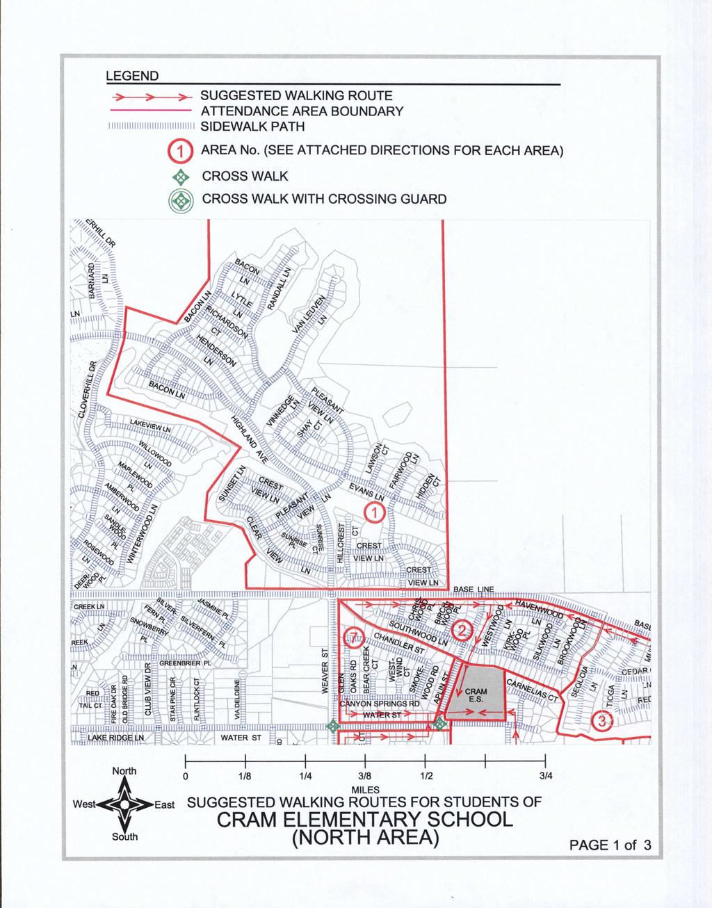
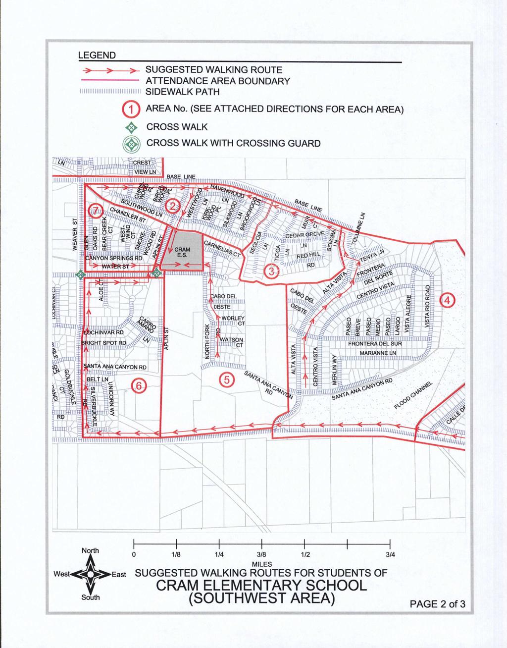
5 SUGGESTED WALKING ROUTES TO CRAM ELEMENTARY SCHOOL Onlv Cross Streets At Intersections NEVER MID BLOCKII AREA No 1 If you live north of Base Line Use crosswalk at the intersection of Base Line and Weaver to cross over Base Line Walk east on the sidewalk along the south side of Base Line to the sidewalk located on the east side of Aplin Street Walk south on the sidewalk along the east side of Aplin Street to the entrance of Cram Elementary School Reverse path to return home AREA No 2 If you live south of Base Line on Southwood Lane Havenwood Lane Fairwood Lane Chriswood Place Birchwood Place Westwood Lane Kirkwood Place Silkwood Lane or Brookwood Lane Walk south on the sidewalk along the east side of Aplin Street to the entrance of Cram Elementary School Reverse path to return home AREA No 3 If you live south of Base Line on Sequoia Lane Tioga Lane Ansel Lane Muir Court Sonora Lane Red Hill Road Cedar Grove Lane Tolumne Lane Tenya Court or Tenya Lane Walk west on the sidewalk along the south side of Base Line to the intersection of Aplin Street Walk south on the sidewalk along the east side of Aplin Street to the entrance of Cram Elementary School Reverse path to return home AREA No 4 If you live south of Base Line on Alta Vista Cabo Del Oeste Frontera Del Sur Marianne Lane Santa Ana Road east of Alta Vista Centro Vista Merlin Way Paseo Breve Paseo Medio Paseo Largo Vista Alegre or Vista Rio Road Walk north on the sidewalk along Alta Vista to Tolumne Lane Continue walking north on the sidewalk along the west side of Tolumne Lane to the intersection of Base Line Walk west on the sidewalk along the south side of Base Line to the intersection of Aplin Street Walk south on the sidewalk along the east side of Aplin Street to the entrance of Cram Elementary School Reverse path to return home AREA No 5 If you live on Greenspot Road Santa Ana Canyon Road west of Alta Vista and east of Aplin Street North Fork Road Watson Court Worley Court Cabo Del Oeste Water Street or Cornelias Court Walk west on the sidewalk along the north side of Water Street to the entrance of Cram Elementary School Reverse path to return home
6 AREA No 6 If you live on Greenspot Road Santa Ana Canyon Road west of Aplin Street Silverbuckle Court Silverbuckle Road Unicorn Way Goldbuckle Road Belt Lane Brightspot Road Lochinvar Road Aplin Street Carro Amano Lane Aloe Court or Water Street Walk east on the sidewalk along the south side of Water Street to the intersection of Aplin Street Use crosswalk to cross over Water Street Use crosswalk to cross over Aplin Street Walk east on the sidewalk along the north side of Water Street to the entrance of Cram Elementary School Reverse path to return home AREA No 7 If you live on Weaver Street Glen Oaks Road Bear Creek Court West Wind Court Smokewood Court Canyon Springs Road Aplin Street or Chandler Road Walk east on the sidewalk along the north side of Water Street to the intersection of Aplin Street Use crosswalk to cross over Aplin Street Walk east on the sidewalk along the north side of Water Street to the entrance of Cram Elementary School Reverse path to return home AREA No 8 If you live north of Greenspot Road on Mission Street Vista Clara Street Via Alice Street Santa Paula Street La Cresta Street Calle Del Rio Street Santa Angela Street Calle Larissa Street La Monica Street San Benito Street La Nita Street Camino Cielo Street Via Obra Court Mclean Street Cochrane Street Kent Street Newman Court or Sewell Court Walk west on the sidewalk along the north side of Greenspot Road to the intersection of Weaver Street Walk north on the sidewalk along the east side of Weaver Street to Water Street Walk east on the sidewalk along the south side of Water Street to Aplin Street Use the crosswalk at Aplin Street to Cross over Water Street Again use crosswalk to cross over Aplin Street Walk east on the sidewalk along the north side of Water Street to the entrance of Cram Elementary School Reverse path to return homel
7 C FI 4VI LOOK BOTH WAYS BEFORE CROSSING LEFT RIGHT LEFT AGAIN WALK DONT RUN ACROSS THE STREET CROSS ONLY AT SAFE CORNERS EVEN IF YOU WALK FARTHER CHOOSE THE ROUTE WITH FEWEST STREETS TO CROSS CROSS STREETS AT CROSSWALKS WHEN POSSIBLE OBEY TRAFFIC SIGNS AND SIGNALS FACE TRAFFIC WHEN WALKING ON STREETS WITHOUT SIDEWALKS WATCH FOR TURNING CARS KEEP FROM WALKING BETWEEN PARKED CARS REFUSE TO RIDE WITH STRANGERS
2019 Federal Transportation Improvement Program
 VEN051211 Ventura SCCAB VEN051211 CAX63 L NON-EXEMPT 0 Description: PTC 4,417 Agency CAMARILLO LAS POSAS ROAD FROM VENTURA BLVD TO PLEASANT VALLEY ROAD WIDEN FROM 2 TO 6 LANES CITY FUNDS 4,417 4,417 4,417
5.13 Soledad. Demographic Profile. Disadvantaged Communities. Safety Profile
 5.13 Soledad Demographic Profile The City of Soledad is a small town in the Salinas Valley with 26,065 people, as reported by the California Department of Finance 2017 data. Soledad is a relatively young,
Lesson #7. Review: Lesson #6 Destination: Eureka. SKILLS A. Protected Left Turns
 SKILLS A. Protected Left Turns Lesson #7 Review: Lesson #6 Destination: Eureka 1. The only time you are protected from oncoming traffic is when you have a green left turn arrow 2. Oncoming traffic has
City of San Juan Capistrano Agenda Report
 8/1/2017 City of San Juan Capistrano Agenda Report E8 TO: FROM: Honorab.le Mayor and Members. of the City Council ;i1'en Siegel, City Manager SUBMITTED BY: Steve May, Public Works and Utilities Director
San Mateo County Bicycle and Pedestrian Advisory Committee
 San Mateo County Bicycle and Pedestrian Advisory Committee January 19, 2017 Emma Shlaes, Policy Manager About SVBC Mission Our purpose is to create a healthy community, environment, and economy through
Applications for Funding
 Coordinated Call for Projects Second Cycle of OBAG, TLC and PBTF Funding Applications for Funding As of The following table lists the applications for funding available through the Coordinated Call for
Controlled. Semi-Controlled PAGE 01 CHAPTER 12 INTERSECTIONS
 PAGE 01 CHAPTER 12 INTERSECTIONS You will cross many intersections while driving. Intersections are especially dangerous because vehicles are crossing each other s driving path. Many crashes happen at
SDForward.com/networks PHASE YEAR (IN ALL NETWORK CONCEPTS) ESTIMATED CAPITAL COSTS ($2018) MILLIONS* PROJECT NAME
 ESTIMATED CAPITAL COSTS ($2018) MILLIONS* PROJECT NAME") Bayshore Bikeway Segment 8B: Ada Street to Palomar Street $1.64 Border to Bayshore Bikeway $10.18 Central Avenue Bikeway $4.62 North Park/Mid-City Bikeways: Howard $8.42 North Park/Mid-City Bikeways: Monroe
Bayshore Bikeway Segment 8B: Ada Street to Palomar Street $1.64 Border to Bayshore Bikeway $10.18 Central Avenue Bikeway $4.62 North Park/Mid-City Bikeways: Howard $8.42 North Park/Mid-City Bikeways: Monroe
Multi-Modal Traffic Analysis. Parisi and Associates
 Mill Valley to Corte Madera Bicycle and Pedestrian Corridor Study Appendix D: Multi-Modal Traffic Analysis Prepared by Parisi and Associates August 2009 Appendix D - Multi-Modal Traffic Analysis Table
WELCOME. Thank you for joining us at the Second Public Workshop for the Carlsbad Pedestrian Master Plan. We look forward to receiving your feedback.
 City of Carlsbad Pedestrian Master Plan: WELCOME WELCOME Please Sign In Provide Input at Flip Charts Review Boards Presentation of Draft Plan Thank you for joining us at the Second Public Workshop for
Lessons Learned from Cycle Tracks (Class IV Bikeways) Design Practice
 Design Practice") Lessons Learned from Cycle Tracks (Class IV Bikeways) Design Practice By: Min Zhou, P.E., Principal/Vice President KOA Corporation 1 What is a Cycle Track (Class IV) TYPICAL BIKEWAY CLASSIFICATION CLASS
Lessons Learned from Cycle Tracks (Class IV Bikeways) Design Practice By: Min Zhou, P.E., Principal/Vice President KOA Corporation 1 What is a Cycle Track (Class IV) TYPICAL BIKEWAY CLASSIFICATION CLASS
SANTA CRUZ/ALAMEDA ROAD CONFIGURATIONS INTERSECTION AND STREET VIEWS
 SANTA CRUZ/ALAMEDA ROAD CONFIGURATIONS INTERSECTION AND STREET VIEWS This presentation includes the documentation found in Safety Issues Report sections: 1, 7, 8, 9, 10, 11, 12, and18 The 3 sections of
St. Francis Drive through the City of Santa Fe Corridor Study
 VII. ENGINEERING AND ENVIRONMENTAL EVALUATION TRAIL CONNECTIVITY In the southern portion of the Corridor there is a lack of a sidewalk, trail or bicycle facility within the right-ofway. However, the City
SAN BENITO COUNTY Bikeway and Pedestrian Master Plan
 SAN BENITO COUNTY Bikeway and Pedestrian Master Plan Prepared for: Council of San Benito County Governments Prepared by: Alta Planning + Design December 2009 ACKNOWLEDGEMENTS Council of San Benito County
California Science Test and CAA for Science Pilot Administration: High School Grade Assignment County: Los Angeles List D
 19648080000000 Montebello Unified 19648080124552 Applied Technology Center 11 19648080000000 Montebello Unified 19648086130520 Beacon Day 11 19648080000000 Montebello Unified 19648081930825 Bell Gardens
California Community Colleges ISP Usage for June 2004
 California Community Colleges 262.8 22,787.1 236.5 20,508.4 210.2 18,229.7 184.0 15,951.0 157.7 13,672.3 131.4 11,393.5 105.1 9,114.8 78.8 6,836.1 52.6 4,557.4 26.3 2,278.7 10867 Foothill-DeAnza Community
Student Pedestrian Safety Fiddlers Canyon Elementary Community Council 2012
 Student Pedestrian Safety Fiddlers Canyon Elementary Community Council 2012 Introduction Fiddlers Canyon Elementary students must cross North Wedgewood Lane and Fiddlers Canyon Drive in order to come to
Santa Ynez Valley Homes for Sale Market Activity Report for the Period of September 1, 2017 to September 30, 2017
 NEW LISTINGS Condo/Townhouse 1676 Maple Solvang 2/1 n/a $349,000 Condo/Townhouse 612 Hillside Solvang 4/3 0.22 $849,000 Residential 535 Waite Los Alamos 2/1 0.11 $529,000 Residential 525 Waite Los Alamos
Subject: Bike Project Field Trial Must Validate Bike Safety Claims
 April 12, 2017 To: Menlo Park City Council Subject: Bike Project Field Trial Must Validate Bike Safety Claims A few weeks ago, a collision between my road bike and a white pick-up truck on Woodside Road
SAN FRANCISCO MUNICIPAL TRANSPORTATION AGENCY Order # 5194 FOR PUBLIC HEARING
 The Sustainable Streets Division of the San Francisco Municipal Transportation Agency will hold a public hearing on Friday, December 6, 2013, at 10:00 AM, in Room 416 (Hearing Room 4), City Hall, 1 Dr.
Meadow Woods Elementary School
 Drag and drop pic and stretch/crop to the limits of the blue rectangle (delete this text box) Meadow Woods Elementary School Drag and drop pic and stretch/crop to the limits of the blue rectangle (delete
Hidden Oaks Elementary School
 Hidden Oaks Elementary School SCHOOL ROUTE PLAN For HIDDEN OAKS ELEMENTARY SCHOOL LOCATION 13 ORANGE COUNTY Prepared for: ORANGE COUNTY SCHOOL ASSESSMENT PROGRAM ORANGE COUNTY PUBLIC WORKS Traffic Engineering
Bicycle and Pedestrian Facilities Toolbox (Excerpt from Figure 3.1)
") Appendix B Neighborhood Connections Summaries This Appendix is a supplement to the information presented in Chapter 3 Connect People. The Appendix includes a summary or profile for each of the proposed
Appendix B Neighborhood Connections Summaries This Appendix is a supplement to the information presented in Chapter 3 Connect People. The Appendix includes a summary or profile for each of the proposed
OCEAN TO SOUND RELAY SEPTEMBER 25, 2016 COURSE DESCRIPTION LEG 1
 GENERAL DESCRIPTION: 5.9 MILES--ALL FLAT START: JONES BEACH STATE PARK FIELD #2 FINISH: CEDAR CREEK PARK (SEAFORD) OCEAN TO SOUND RELAY LEG 1 0.0 miles START ON BOARDWALK AT EAST END OF JONES BEACH PARKING
Atwood Avenue Fair Oaks Avenue Cottage Grove Road
 Atwood Avenue Fair Oaks Avenue Cottage Grove Road Agenda Purpose Review project scope & goals Present design alternatives Gather feedback Answer Questions Format Open House Presentation Q&A Open House
SAN FRANCISCO MUNICIPAL TRANSPORTATION AGENCY Order # 5068 FOR PUBLIC HEARING
 The Sustainable Streets Division of the San Francisco Municipal Transportation Agency will hold a public hearing on Friday, March 8, 2013, at 10:00 AM, in Room 416 (Hearing Room 4), City Hall, 1 Dr. Carlton
Eligible Schools. Number of K-5/K-8 public schools 219 SRTS plans complete/funding applied 63 Number of schools considered in
 Study Goals Prioritize Miami-Dade elementary and K-8 schools for Safe Routes to School (SRTS) infrastructure improvements Develop SRTS plans and infrastructure improvements for 10 priority schools Prepare
Planned Date of Obligation for 4/1/15 and beyond (please enter as MM/DD/YY)
") for 4/1/15 City of Clovis 5208-149 LSTMP454 Pedestrian Bridge / SR 168 NI Master Plan 4/30/2015 $168,000 $168,000 City of Clovis 5208-139 FRE130005 Shaw, Clovis-Sunnyside Street Maintenance 5/1/2015 CON
for 4/1/15 City of Clovis 5208-149 LSTMP454 Pedestrian Bridge / SR 168 NI Master Plan 4/30/2015 $168,000 $168,000 City of Clovis 5208-139 FRE130005 Shaw, Clovis-Sunnyside Street Maintenance 5/1/2015 CON
May 20, 2016 PUBLIC HEARING RESULTS
 The Sustainable Streets Division of the San Francisco Municipal Transportation Agency held a public hearing on Friday,, at 10:00 AM, in Room 416 (Hearing Room 4), City Hall, 1 Dr. Carlton B. Goodlett Place,
RE: Natomas Landing (P99-091)
") August 2, 2008 David Hung, Associate Planner Current Planning Division Development Services Department 300 Richards Boulevard, 3rd Floor Sacramento, CA 95811 RE: Natomas Landing (P99-091) Dear Mr. Hung:
August 2, 2008 David Hung, Associate Planner Current Planning Division Development Services Department 300 Richards Boulevard, 3rd Floor Sacramento, CA 95811 RE: Natomas Landing (P99-091) Dear Mr. Hung:
Circulation and Mobility
 SECTION 4 Circulation and Mobility OVERVIEW The first phase of the circulation analysis is to address specific concerns regarding the circulation system in the vicinity of the Gateway Specific Plan area
Pedestrian Safety Tips
 Pedestrian Safety Tips FACT: Pedestrian safety is the responsibility of BOTH the drivers on the road and the pedestrians. FACT: NO vehicle can Stop on a Dime. The average passenger vehicle traveling 40
Chapter 315 TRAFFIC CONTROL DEVICES. Section Manual and Specifications For Traffic Control Devices.
 Chapter 315 TRAFFIC CONTROL DEVICES Section 315.010. Authority To Install Traffic Control Devices. The City Traffic Engineer shall place and maintain traffic control signs, signals and devices when and
Agenda Item No. 6C ATTACHMENT 1
 ATTACHMENT District Bike Plan Proposed s Hillside Ln Livermore D TAC
Unit Five : Driving In Neighborhoods
 Unit Five : Driving In Neighborhoods What Are We Going To Do Today? Students will be able to describe the skills necessary to How safely and do legally you make drive in a residential How do area. you
Orinda Bicycle, Trails and Walkways Master Plan
 Orinda Bicycle, Trails and Walkways Master Plan Public Meeting October 15, 2008 Presented by: Ian Moore, Alta Lauren Ledbetter, Alta Bruce Wolff, Alta Introductions City of Orinda Monica Pacheco, Assistant
01. VICINITY OF GREENBRAE POC: EXISTING CONDITIONS
 01. VICINITY OF GREENBRAE POC: EXISTING CONDITIONS Existing Bus Stop Existing US101 On-ramp Existing POC Old Redwood Highway Rich Street City ROW Environmental Study Limit Industrial Way NO DESIGNATED
Southern Marin Unincorporated Area Non-Motorized Travel Vision Plan
 Southern Marin Unincorporated Area Non-Motorized Travel Vision Plan Executive Summary Tamalpias Valley, Homestead Valley, Almonte, Strawberry and Muir Woods Park are all part of the unincorporated area
Leg #1 (GUNLOCK AND LOADED) Miles
 Miles") Leg #1 (GUNLOCK AND LOADED)- 6.07 Miles Difficulty: Easy to Moderate This is a nice leg for those who like running downhill. It s a beautiful run down the Santa Clara River canyon to the point where the
Leg #1 (GUNLOCK AND LOADED)- 6.07 Miles Difficulty: Easy to Moderate This is a nice leg for those who like running downhill. It s a beautiful run down the Santa Clara River canyon to the point where the
Eliminate on-street parking where it will allow for a dedicated bus only lane %
 Traffic Dashboard Priorities Survey Responses Introduction 1) Are you familiar with bus rapid transit (BRT)? a. No, BRT is new to me. 597 23.5% b. I ve heard of BRT, but I don t know much about it. 1,136
San Bernardino County Non-Motorized Transportation Plan - Chapter 5
 City of Yucaipa Population 51,476 City Overview Yucaipa is located in the eastern portion of the San Bernardino Valley area, at the foot of the San Bernardino Mountains, between the Cities of Redlands
Tour de Summer Camps Rider Guide
 Tour de Summer Camps Rider Guide Event Schedule and Highlights 5:30 AM Parking lot opens 5:30 AM Breakfast Begins 6:00 AM Check-in for Wristbands/Registration opens 6:45 AM Welcome at the Start Line 6:52
Bus Rapid Transit on Silicon Valley s El Camino Real: Working Together to Create a Grand Boulevard Steven Fisher
 Bus Rapid Transit on Silicon Valley s El Camino Real: Working Together to Create a Grand Boulevard Steven Fisher Senior Transportation Planner Santa Clara Valley Transportation Authority San Jose, CA How
Neighborhood Environment Walkability Scale Youth (NEWS-Y) Adolescent Version
 Adolescent Version") Neighborhood Environment Walkability Scale Youth (NEWS-Y) Adolescent Version From Active Where? study Information on scoring can be found at: http://www.drjamessallis.sdsu.edu/documents/news-yscoring.pdf
Neighborhood Environment Walkability Scale Youth (NEWS-Y) Adolescent Version From Active Where? study Information on scoring can be found at: http://www.drjamessallis.sdsu.edu/documents/news-yscoring.pdf
CARE AND VIGILANCE SAVE LIVES!
 CARE AND VIGILANCE SAVE LIVES! PEDESTRIAN, Be Safety Conscious! Each day, approximately ten pedestrians are involved in traffic accidents throughout Québec. If you use the province s road network on foot,
TITLE VII: TRAFFIC CODE 70. GENERAL PROVISIONS 71. TRAFFIC RULES 72. PARKING REGULATIONS 73. BICYCLES AND MOTORCYCLES 74.
 TITLE VII: TRAFFIC CODE Chapter 70. GENERAL PROVISIONS 71. TRAFFIC RULES 72. PARKING REGULATIONS 73. BICYCLES AND MOTORCYCLES 74. TRAFFIC SCHEDULES 75. PARKING SCHEDULES 1 2 Vine Grove - Traffic Code CHAPTER
City of Walnut Creek TELEGRAPH AVENUE BART LINE SELF-GUIDED TOD TOUR 19TH STREET BART STATION
 TELEGRAPH AVENUE City of Walnut Creek BART LINE SELF-GUIDED TOD TOUR 19TH STREET BART STATION Self-Guided TOD Tour With the Walnut Creek BART Station located squarely within its boundaries, the West Downtown
HELM RANCH ROUND 2 - COMMUNITY WORKSHOP AND OPEN HOUSE SUMMARY
 HELM RANCH ROUND 2 - COMMUNITY WORKSHOP AND OPEN HOUSE SUMMARY Tarpey Elementary School, Clovis, CA October 15, 2014 6:30pm-8:30pm OVERVIEW On Wednesday, October 15, 2014, staff from the City of Clovis
Legend. Restroom. Basketball. Tennis. Clubhouse. Field Tot Friendly. Picnic Tables Trail. Playground
 Legend Basketball Restroom Clubhouse Tennis Field Tot Friendly Picnic Tables Trail Playground Arlington Park and Clubhouse 1120 Arlington Blvd. Tennis courts, picnic tables, barbecues, playground equipment,
TRANSPORTATION TRAINING TOPICS. April 6, 2010
 TRANSPORTATION TRAINING TOPICS April 6, 2010 Roles of Transportation Providers Context and Policy Makers Division of Transportation and Traffic Other City Operations Other Transportation Operators CMA
Planning Committee STAFF REPORT
 Planning Committee STAFF REPORT Meeting Date: December 7, 2011 Subject Summary of Issues Recommendations Financial Implications Options Attachments Applications Received through the CC TLC and PBTF Call
including shade trees; Recommend minimum 13 ft total sidewalk
 Appendix B Projects From Other Plans Location Type of Project Description West. Julian St. Intersection and streetscape along West Julian St. Intersection and scape : Add high visibility side street crosswalks
TOWN OF MORAGA. CAMINO PABLO & CANYON ROAD INTERSECTION IMPROVEMENTS Public Information Meeting February 20, 2019
 TOWN OF MORAGA CAMINO PABLO & CANYON ROAD INTERSECTION IMPROVEMENTS Public Information Meeting February 20, 2019 Edric Kwan, Public Works Director April Malvino Miller, BKF Project Design Manager Shawn
REQUIREMENTS FOR TRAFFIC CONTROL PLAN SUBMISSION
 REQUIREMENTS FOR TRAFFIC CONTROL PLAN SUBMISSION A draft traffic control plan, consistent with the following applicable conditions, must be included in every permit application submitted to the City of
Durrance Elementary School
 Durrance Elementary School SCHOOL ROUTE PLAN For DURRANCE ELEMENTARY SCHOOL LOCATION 9 ORANGE COUNTY Prepared for: ORANGE COUNTY SCHOOL ASSESSMENT PROGRAM ORANGE COUNTY PUBLIC WORKS Traffic Engineering
2018 Homestead Christmas Cup XXV
 Welcome to the 25 th Annual Homestead Christmas Cup! There are four divisions, Gold, Silver 1, Silver 2 and Bronze. Standings and schedules for each division as well as a consolidated schedule are listed
2017 Adult Preliminary Approved Tournaments Updated 6/1/17
 2017 Adult Preliminary Approved Tournaments Updated 6/1/17 * For the most updated version, please click the refresh button *Tournaments will appear on the 2017 TennisLink Online Calendar once required
San Ramon Elementary School. Travel Plan
 San Ramon Elementary School Travel Plan TABLE OF CONTENTS 1. PURPOSE... 1 1.1. SR2S PLANNING, IMPLEMENTATION AND MONITORING... 1 1.2. MARIN COUNTY MEASURE A... 1 2. SAN RAMON ELEMENTARY SCHOOL PROFILE...
Use this guide to learn more about walkability and how you can make your community safer to walk
 Walkability Guide Do You Enjoy Walking In Your Community? Use this guide to learn more about walkability and how you can make your community safer to walk 2 About This Guide Circulate San Diego believes
Barriers to Alternative Transportation Modes RTP Public Input Survey - Summary of Responses -
 Barriers to Alternative Transportation Modes RTP Public Input Survey - Summary of Responses - Survey Information: County Population 262,382 (2010) 274 survey participants Survey accessed online at www.sccrtc.org
SAN FRANCISCO MUNICIPAL TRANSPORTATION AGENCY Order # 5221 FOR PUBLIC HEARING
 The Sustainable Streets Division of the San Francisco Municipal Transportation Agency will hold a public hearing on Friday, FEBRUARY 14, 2014, at 10:00 AM, in Room 416 (Hearing Room 4), City Hall, 1 Dr.
Multilingual Living Information
 4 Traffic regulations 4-1 Japanese traffic regulations In Japan traffic regulations are established for each of pedestrians, automobiles and motorbikes and bicycles. Learning these rules quickly and correctly
WEDNESDAY, SEPTEMBER 6, :00 PM City Council Chambers, 1 Civic Center Drive, San Marcos, CA 92069
 MINUTES Meeting of the San Marcos Traffic Commission WEDNESDAY, SEPTEMBER 6, 2017 6:00 PM City Council Chambers, 1 Civic Center Drive, San Marcos, CA 92069 CALL TO ORDER: Vice Chairman Rico called the
Why NOT Google? (County GIS versus Google) Laurie J. Kurilla County Geographic Information Officer
 Laurie J. Kurilla County Geographic Information Officer") Why NOT Google? (County GIS versus Google) Laurie J. Kurilla County Geographic Information Officer Disclaimer This is not a Google bashing This is a discussion about Data This is a discussion about business
Why NOT Google? (County GIS versus Google) Laurie J. Kurilla County Geographic Information Officer Disclaimer This is not a Google bashing This is a discussion about Data This is a discussion about business
11/3/2017 VIA . RE: River Oaks Phase 2 (P17-051)
") 11/3/2017 VIA EMAIL Ethan Meltzer, Assistant Planner City of Sacramento Community Development Department 300 Richards Blvd., 3 rd Floor Sacramento, CA 98811 RE: River Oaks Phase 2 (P17-051) Dear Mr. Meltzer:
11/3/2017 VIA EMAIL Ethan Meltzer, Assistant Planner City of Sacramento Community Development Department 300 Richards Blvd., 3 rd Floor Sacramento, CA 98811 RE: River Oaks Phase 2 (P17-051) Dear Mr. Meltzer:
Henry Clay/John M. Gandy Elementary Schools
 Run: 1 Bus: 289 Start run at the intersection of: Arbor Oak Drive at Washington Highway (7:20am) Left onto Arbor Oak Drive Continue on Arbor Oak Drive to Winter Oak Left on Winter Oak Drive Right on Arbor
CITY OF BEVERLY HILLS TRAFFIC & PARKING COMMISSION
 CITY OF BEVERLY HILLS TRAFFIC & PARKING COMMISSION Meeting of TO: FROM: Bijan Vaziri, Senior Transportation Engineer SUBJECT: Traffic Engineer Quarterly Report Traffic Engineering Activities January 2014
Castro Valley Municipal Advisory Council March 19, 2018
 Castro Valley Municipal Advisory Council March 19, 2018 1 Background 2 Draft Bicycle Vision and Pedestrian Networks 3 Next Steps 4 Updates Agenda 2 PROJECT AREA: Unincorporated Areas of Alameda County
'Tis the Season...for Construction Multi Modal Project Updates
 Page 1 of 5 September 13th, 2013 Free Transit Days Tuesday, Sept. 24th: Sponsored by Methodist Thrift Store Tuesday, Oct. 29th: Sponsored by Methodist Thrift Store Needham Elementary Celebrates Safe Routes
City of Sammamish. Welcome. Issaquah-Fall City Road Improvements Project Phase I Design: 242nd Avenue SE to Klahanie Drive SE
 Welcome Welcome to the third community meeting for the Issaquah-Fall City Road Improvements Project. AGENDA 6:00 p.m. Welcome and sign-in 6:10 p.m. Presentation 6:50 p.m. Open house Learn about the roadway
COASTAL RAIL TRAIL ROSE CREEK BIKEWAY PROJECT COMMUNITY WORKSHOP #2 AUGUST 15, 2013
 COASTAL RAIL TRAIL ROSE CREEK BIKEWAY PROJECT COMMUNITY WORKSHOP #2 AUGUST 15, 2013 CHRIS CARTERETTE, AICP PROJECT MANAGER Chris.Carterette@sandag.org Direct: 619-699.7319 REGIONAL PLANNING BACKGROUND
WalkSafe Vocabulary Matching. 1 pedestrian A marked place to cross the street. 2 intersection A person who is walking. 3 crosswalk. 4 curb.
 WalkSafe Vocabulary Matching Name Directions: Draw a line from the vocabulary word to its definition. 1 pedestrian A marked place to cross the street. 2 intersection A person who is walking. 3 crosswalk
Lesson #13. Review: Lesson #12 Destination: Washington (Business and Residential)
") Lesson #13 Review: Lesson #12 Destination: Washington (Business and Residential) SKILLS A. Parallel parking (Not on final driver s test) 1. Signal leaving roadway 2. Pull parallel to vehicle you are going
Lesson #13 Review: Lesson #12 Destination: Washington (Business and Residential) SKILLS A. Parallel parking (Not on final driver s test) 1. Signal leaving roadway 2. Pull parallel to vehicle you are going
EL CAMINO REAL BUS RAPID TRANSIT PROJECT
 EL CAMINO REAL BUS RAPID TRANSIT PROJECT Would upgrade the current 522 Rapid Bus to BRT status by making changes to El Camino Real and The Alameda that make transit FAST, FREQUENT AND RELIABLE and make
Bicycle and Pedestrian Advisory Committee (BPAC) Meeting Agenda
 Meeting Agenda") CITY OF ROHNERT PARK Development Services Bicycle and Pedestrian Advisory Committee (BPAC) Meeting Agenda 5:30 PM, Monday, December 18, 2017 Rohnert Park City Hall, Conference Room 2A 130 Avram Avenue,
CITY OF ROHNERT PARK Development Services Bicycle and Pedestrian Advisory Committee (BPAC) Meeting Agenda 5:30 PM, Monday, December 18, 2017 Rohnert Park City Hall, Conference Room 2A 130 Avram Avenue,
PEDESTRIAN SAFETY ASSESSMENT SR 934/NORMANDY DRIVE AND 71 Street
 PEDESTRIAN SAFETY ASSESSMENT SR 934/NORMANDY DRIVE AND 71 Street PRESENTED BY MISLEIDYS LEON TRAFFIC SAFETY PROGRAM ENGINEER FLORIDA DEPARTMENT OF TRANSPORTATION (FDOT) BACKGROUND In response to citizen
Planned Improvements from Sector & Area Plans that have been added to the MTP
 Appendix P Bikeway Projects in Currently Approved Plans Planned Improvements from Sector & Area Plans that have been added to the MTP Airport Viaduct Trail Connection to National Airport Implement a pedestrian/bicycle
Lake Waterford Community Association Meeting. November 15, 2016
 Lake Waterford Community Association Meeting November 15, 2016 Introduction Staff Introduction Project Overviews - Completed Projects - Pavement Management Program - Pasadena Road Sidewalk Improvements
SOLANA BEACH BICYCLE TRANSPORTATION PLAN SECOND ADDENDUM
 SOLANA BEACH BICYCLE TRANSPORTATION PLAN SECOND ADDENDUM Prepared by the City of Solana Beach January 2005 Introduction In June of 1993, the Solana Beach City Council adopted a Bikeway Master Plan as directed
APPENDIX B. Storm and Precipitation Tracking
 APPENDIX B Storm and Precipitation Tracking Table B-1a. Rain and Stream Gages in Goleta and Santa Barbara Corresponding Site Map: Figure B-1a Site # Stream Gage Location Rain Gage Location Name Location
Parent Survey Report: One School in One Data Collection Period
 Parent Survey Report: One School in One Data Collection Period School Name: Bilquist Elementary School Set ID: 15803 School Group: Clackamas County Month and Year Collected: December 2016 School Enrollment:
The Great 33 ⅓ Relay Run Route Details
 The Great 33 ⅓ Relay Run Route Details Saturday, December 2 nd 2017 Mile 1: Dublin From: O Sullivan s Pub, Carlsbad To: 13810 Carlsbad Blvd (Intersection of 101 & Hemlock St) Approximate Start Time: 8:30am
Builta Arrival and Dismissal Procedures
 Builta Arrival and Dismissal Procedures The safety of your children/our students is our first concern. The system now in place establishes a pattern for children to arrive and depart safely from Builta.
Route 1 and Harrison Road Intersection Improvements
 Route 1 and Harrison Road Intersection Improvements April 27, 2016 Randy McKinney, P.E. Virginia Department of Transportation, Fredericksburg District Area Construction Engineer Route 1 and Harrison Road
C/CAG. Sunnybrae Elementary School Walking and Bicycling Audit. San Mateo-Foster City School District JUNE 2013
 Sunnybrae Elementary School Walking and Bicycling Audit JUNE 2013 San Mateo-Foster City School District C/CAG City/County Association of Governments of San Mateo County SUNNYBRAE ELEMENTARY SCHOOL WALKING
Little Italy Parking District Street Parking Conversions. Maps created by John Li Mandri; Little Italy Assn.
 Little Italy Parking District Street Parking Conversions Maps created by John Li Mandri; Little Italy Assn. Street Parking Conversion Totals Columbia Street 25 29 new diagonal parking spaces State Street
Hospital Link Project Project Update September 2017
 Hospital Link Project Project Update September 2017 General The project provides a link from Riverside Drive and the Transitway to the Hospital Link Road. Construction is well underway. Read on for important
San Rafael School District. Task Force Meeting Notes. November 5, 2012
 San Rafael School District Task Force Meeting Notes November 5, 2012 Attendees (8) Wendi Kallins Program Director for Safe Routes to Schools; Laura Kelly Volunteer Liaison for Safe Routes to Schools; Leslie
SAN ANTONIO WATER SYSTEM P. O. BOX 2449 SAN ANTONIO, TEXAS TABULATION OF BIDS
 GROUP 1 38th Street ACCD (Boerne Stage Rd) Acequia Park Lawn Maintenance MOW 40.00 87.70 55.00 55.00 78.00 12 mows / contract TOTAL 480.00 1,052.40 660.00 660.00 936.00 Afton Oaks Air Force Village #1
Pedestrian Safety Action Plan Bicycle Safety Action Plan
 Pedestrian Safety Action Plan Bicycle Safety Action Plan January 24, 2017 VISION: Safe travel for all MISSION STATEMENT: Partner with the community to plan and fund transportation projects and programs
BRR Leg 25 (4.3 miles, Moderate)
") BRR Leg 25 (4.3 miles, Moderate) Min 2290 Max 2492 Ascent +287 Descent -244 0.0 EZ 24 (Bakersville Fire Dept.) 0.0 Cross bridge 0.0 L Route 226 4.3 Red Hill Baptist Church, on L (EZ 25) Leg Notes: 226
BRR Leg 25 (4.3 miles, Moderate) Min 2290 Max 2492 Ascent +287 Descent -244 0.0 EZ 24 (Bakersville Fire Dept.) 0.0 Cross bridge 0.0 L Route 226 4.3 Red Hill Baptist Church, on L (EZ 25) Leg Notes: 226
I-35 COMAL COUNTY OPERATIONAL IMPROVEMENTS
 I- COMAL COUNTY OPERATIONAL IMPROVEMENTS OPEN HOUSE The environmental review, consultation, and other actions required by applicable Federal environmental laws for this project are being, or have been,
Coming soon: big changes to Eagle Road Many say it's about time, too
 Coming soon: big changes to Eagle Road Many say it's about time, too By Cynthia Sewell The Idaho Statesman Edition Date: 06-12-2005 The state's busiest non-interstate road is about to get a makeover. Eagle
California YMCA Youth & Government 70th T&E I Advisor Duties
 California YMCA Youth & Government 70th T&E I Advisor Duties This letter is to inform your delegation of their assigned Advisor Duties. We have done our best to limit the assigned duties to allow advisors
COYOTE CREEK CYCLING CLASSIC
 COYOTE CREEK CYCLING CLASSIC 2010 Event Information & Registration Form The Santa Clara County Council, Boy Scouts of America invites you to the 18th Annual Coyote Creek Cycling Classic, to be held on
SAN FRANCISCO MUNICIPAL TRANSPORTATION AGENCY
 THIS PRINT COVERS CALENDAR ITEM NO. : 10.3 DIVISION: Sustainable Streets Division BRIEF DESCRIPTION: SAN FRANCISCO MUNICIPAL TRANSPORTATION AGENCY Approving traffic and parking modifications to install
Santa Ana Creating Community Together
 City of Santa Ana Creating Community Together Circulation & Housing Element Update Open House Thursday, May 9, 2013 1 General Plan Circulation Element Update Open House #3 2 What is a Circulation Element?
Windy Ridge Elementary School
 Windy Ridge Elementary School SCHOOL ROUTE PLAN For WINDY RIDGE ELEMENTARY SCHOOL LOCATION 54 ORANGE COUNTY Prepared for: ORANGE COUNTY SCHOOL ASSESSMENT PROGRAM ORANGE COUNTY PUBLIC WORKS Traffic Engineering
CHAPTER 12-7 TRAFFIC CONTROL SIGNS, SIGNALS AND DEVICES
 CHAPTER 12-7 TRAFFIC CONTROL SIGNS, SIGNALS AND DEVICES 12-7-1 OBEDIENCE No person shall violate any rule, regulation, traffic direction, sign or marking adopted, prescribed, or established in accordance
San Fernando School Route Improvement Program Phase 3 Cycle 2 Federal Grant Application Project List
 San Fernando School Route Improvement Program Phase 3 Cycle 2 Federal Grant Application Project List Since this is Phase 3 of San Fernando s School Route Improvement Program some projects have already