PARK(ING) DAY 2018 GUIDELINES
|
|
|
- Ada Grant
- 5 years ago
- Views:
Transcription
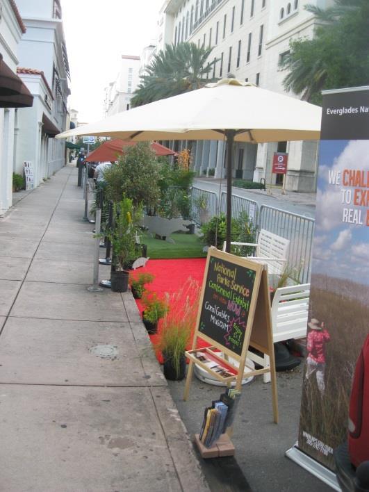
1 PARK(ING) DAY 2018 GUIDELINES PARK(ING) Day happens once a year, on the third Friday in September. This year the event takes place on Friday September 21. It is an opportunity for people to temporarily turn on-street parking spaces into public places. This international event raises awareness about the importance of a walkable, livable, healthy city and helps people re-think how our streets can be used. This document explains the City of Coral Gables requirements for this event. Any use of the right-of-way, including the use of on-street parking spaces for PARK(ING) Day, requires a permit. But don t worry, we ve created a special type of free permit to make it easy for you to participate if you partner with The City of Coral Gables. Your temporary park will need to meet all of the requirements outlined below, and you must submit your application no later than Wednesday September 12, 2018 to manderson@coralgables.com. For more information on the Coral Gables PARK(ING) Day event please visit APPLICATION You need to submit a site plan for your park so that we know what you re planning. This doesn t need to be fancy and it s okay if you re not an engineer, architect or artist! The site plan should be based on the PARK(ING) Day Application and must include: A. Location description of parking space(s). B. Description of parking space(s) location. C. Height of items and setback dimensions from curb D. Barrier (e.g., planters or barricade) placement
2 PARKING SPACE RESERVATIONS There are four steps you need to take to reserve your parking spaces: 1) Identify the space(s) you want to use. You ll need to provide this information in your application. The parking space number is identified on the meter pole. If the parking space does not have a meter, describe as accurately as possible, the location of the space, including the closest address. 2) Talk to adjacent property/business owners and let them know what you are planning. Let them know how many spaces you will use, when you will use them and what they can expect to see in the space. 3) The City s Parking Department will reserve the space for you by placing bags or barricades in place. 4) Verify that your space has been reserved by (DATE/TIME)
, your park must occupy at least two adjacent parking spaces. Non-arterial streets require only one parking space per park.")
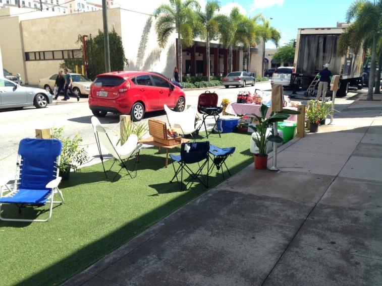
3 DESIGNING YOUR PARK Choose your PARK(ING) spaces carefully! Do not choose a commercial loading zone, disabled parking zone or a space that only allows pick-up and drop-off parking. If you chose an arterial street (typically a major thoroughfare), your park must occupy at least two adjacent parking spaces. Non-arterial streets require only one parking space per park. All parks should be located away from the end of a block with a buffer of at least two parking spaces on either side. This means that you CANNOT build your park in the first two or last two parking spaces closest to the end of the block. SEPERATION FROM TRAFFIC Barriers are required to mark the boundaries of your park and clearly identify the edge of the traffic lane and adjacent parking spaces. The barriers must be at least 36 tall. Large planters will be considered. Your park must stay within its approved parking space(s). HOURS OF OPERATION Your park can be open between 7:00 am and midnight. All set-up and tear down must happen within these hours, however, upon review of application, Public Works may further restrict set-up and tear down times based on rush hour traffic. MAINTAINING MOBILITY As you re setting up and taking down your park, remember to keep the sidewalk and the travel lanes clear. All loading and unloading activities must ensure pedestrian and vehicle mobility. And throughout the day, remember that the pedestrian walkway must be kept clear. Activities in your park shouldn t distract motorists, either. Additionally, to make sure that your park doesn t impede sight lines, keep anything taller than 3 feet within 4 feet of the curb. That means umbrellas, tall plants, and giraffes (just in case ) need to stay closer to the curb than to the travel lane. Nothing taller than 3 feet can abut the edge of the traffic lane. See PARK(ING) Day Application for more information.

4 ACTIVATING THE PARK
: Sod material (over tarp) and potted plants Tables, chairs, or benches Arts and crafts, games, or other cultural activities Art displays or easels Rugs, carpets, blankets, or similar")

5 Allowable Items and Activities We encourage you to try out some of these items and activities to help make your park a comfortable and inviting space (see Attachment A for height and setback requirements): Sod material (over tarp) and potted plants Tables, chairs, or benches Arts and crafts, games, or other cultural activities Art displays or easels Rugs, carpets, blankets, or similar surface coverings Freestanding umbrellas adjacent to the curb Informative signs or displays Restricted Items and Activities (this is not an exhaustive list) We want you to have fun in your park, but we want to keep everyone safe, too. This list isn t intended to be discouraging. If you have questions about why you can t do or use anything listed below, feel free to drop us an (manderson@coralgables.com). Anything that may pose a distraction to drivers is prohibited: Banners Balloons, flashing lights, or other similar objects Canopies or free-standing tents The following items or activities may be a nuisance or pose a safety hazard to neighboring businesses or residents and are therefore prohibited: Sidewalk storage or overflow of activities onto sidewalk Charcoal grills Vending or merchandise display Amplified sound Alcoholic beverages or food service
6 PARK(ING) DAY 2018 APPLICATION DATE: APPLICANT: PHONE: Items and Activities: Please check the boxes that describe the activities and items that you expect to have in your proposed park. If they are not included on the list please describe them below. Refer to the PARK(ING) Day Guidelines for more information about allowed activities and items. ACTIVITIES: ITEMS: Eating Exercise Bench Board games Art Sports Rugs Bikes Music Education Plants/tress Tables Relaxing Turf Additional description: Location: Please identify the space(s) you want to use. In areas with paid parking, you can find the parking space numbers for your park location on the meter pole. Include those numbers on your site plan and below. In areas with unpaid parking or multi-space meters, describe as accurately as you can the location of the park. Include the addresses of the businesses or homes in front of your park. Space Number(s): AND/OR Nearest address: Communication: I, (Applicant), have notified adjacent property/business owners, located at that I plan to participate in PARK(ING) Day I ve advised that I am requesting use of on Friday September 21 from (am/pm) to (am/pm). * Please submit application to MANDERSON@CORALGABLES.COM no later than September 12, 2018 spaces
7 PARK(ING) 2018 DAY SKETCH Indicate type of 36 (minimum height) barricade. * Please submit application to MANDERSON@CORALGABLES.COM no later than September 12, 2018
Visit for more information, including the full 2017 program route.
 Philly Free Streets is a family-friendly, people-powered initiative of the City of Philadelphia that temporarily closes a street route to vehicular traffic, inviting people to bike, walk, and play. Philly
SPECIAL EVENT & RIGHT-OF-WAY PERMIT APPLICATION (Not for Block Parties) JANUARY 2015
 JANUARY 2015") SPECIAL EVENT & RIGHT-OF-WAY PERMIT APPLICATION (Not for Block Parties) JANUARY 2015 FESTIVAL, PARADE, PROCESSION, MARCH, ROAD RACE, BICYCLE RACE, WALK The organizer of a special event must fill out the
SPECIAL EVENT & RIGHT-OF-WAY PERMIT APPLICATION (Not for Block Parties) JANUARY 2015 FESTIVAL, PARADE, PROCESSION, MARCH, ROAD RACE, BICYCLE RACE, WALK The organizer of a special event must fill out the
City of Seattle Edward B. Murray, Mayor
 City of Seattle Edward B. Murray, Mayor Department of Transportation Scott Kubly, Director Eastlake Community Council 117 E Louisa St. #1 Seattle, WA 98102-3278 January 28, 2016 RE: Roosevelt to Downtown
1.3 Pedestrian Environments
 SECTION 1: COMMERCIAL DEVELOPMENT 1.3 Pedestrian Environments Design Principle The quality of the pedestrian environment often defines the overall success of a commercial project. Attention to the development
CURBSIDE ACTIVITY DESIGN
 5 CURBSIDE ACTIVITY DESIGN This chapter provides design guidance for separated bike lanes adjacent to curbside activities including parking, loading and bus stops. Typical configurations are presented
Sidewalk Cafe City of St. Petersburg City Code Chapter 16, Land Development Regulations
 Section 16.50.370 Sidewalk Café Sections: 16.50.370.1 Generally 16.50.370.2 Declarations 16.50.370.3 Definitions 16.50.370.4 Permit Required 16.50.370.5 Application, Permit and Fee 16.50.370.6 Liability
STEERING COMMITTEE MEETING June 17, Streetscape Overview Burlington Comprehensive Master Plan
 STEERING COMMITTEE MEETING June 17, 2015 Streetscape Overview Burlington Comprehensive Master Plan 1 Introduction Slide This slide show was presented to the Burlington Steering Committee on June 17, 2015
City of Albert Lea Policy and Procedure Manual 4.10 ALBERT LEA CROSSWALK POLICY
 4.10 ALBERT LEA CROSSWALK POLICY PURPOSE: Pedestrian crosswalks are an integral part of our transportation infrastructure. To be effective and promote safety, marked crosswalks must be installed after
Village of Plainfield Design and Operational Guidelines for Outdoor Uses within the Public Right-of-Way
 Village of Plainfield Design and Operational Guidelines for Outdoor Uses within the Public Right-of-Way Table of Contents 1. Applicability... 2 Purpose: The Village of Plainfield wishes to allow outdoor
forwarddallas! Implementation Proposed Chapter 43 Code Amendment On-Street Parking
 forwarddallas! Implementation Proposed Chapter 43 Code Amendment On-Street Parking Transportation and Environment Committee Briefing December 10, 2007 PURPOSE Code amendment to establish regulations consistent
CONNECTIVITY PLAN. Adopted December 5, 2017 City of Virginia Beach
 CONNECTIVITY PLAN Adopted December 5, 2017 City of Virginia Beach CONTENTS 1.0 Background & Purpose... 2 2.0 Existing Inventory & Analysis... 3 ViBe District Existing Walking Conditions... 4 3.0 ViBe District
City of Cape Coral Traffic Calming. City Council May 16,
 City of Cape Coral Traffic Calming City Council May 16, 2016 1 In This Presentation Why Traffic Calming? What is Traffic Calming? Examples Traffic Calming in the City of Cape Coral How to develop a Traffic
CITY OF SASKATOON COUNCIL POLICY
 and Parking Stalls Vending ORIGIN/AUTHORITY Legislation and Finance Committee Reports 14-1988, 19-1988, 36-1988; and 4-1994; Administration and Finance Committee Report No. 9-1998; Planning and Operations
Health and the Built Environment Presentation to the Childhood Obesity Conference
 Presentation to the Childhood Obesity Conference By Cole Runge, Principal Planner Brown County Planning Commission September 29, 2011 The built environment strongly influences physical and mental health.
SAN FRANCISCO MUNICIPAL TRANSPORTATION AGENCY BOARD OF DIRECTORS. RESOLUTION No
 SAN FRANCISCO MUNICIPAL TRANSPORTATION AGENCY BOARD OF DIRECTORS RESOLUTION No. 15-031 WHEREAS, Transportation Code Division II, Section 909 authorizes the Director of Transportation to install and permit
SECTION 14: LANDSCAPING AND BEAUTIFICATION
 SECTION 14: LANDSCAPING AND BEAUTIFICATION RULE 14.1 GENERAL PROVISIONS 14.1.1 The rules and guidelines contained in this section have been established to provide proper guidelines for the beautification
David Hung, Associate Planner City of Sacramento Community Development Department 300 Richards Boulevard, 3 rd Floor Sacramento, CA
 June 13, 2016 VIA EMAIL David Hung, Associate Planner City of Sacramento Community Development Department 300 Richards Boulevard, 3 rd Floor Sacramento, CA 959811 RE: Fire Station 14 (DR16-128) Dear Mr.
Report on Walkability Survey and Workshop for ZIP Code Hosted by the Oklahoma City-County Health Department April 13, 2013
 Report on Walkability Survey and Workshop for ZIP Code 73111 Hosted by the Oklahoma City-County Health Department April 13, 2013 On April 13th, the Oklahoma City-County Health Department hosted a community
Chapter 2: Standards for Access, Non-Motorized, and Transit
 Standards for Access, Non-Motorized, and Transit Chapter 2: Standards for Access, Non-Motorized, and Transit The Washtenaw County Access Management Plan was developed based on the analysis of existing
Road Usage Permit Application Form
 15/06/2012 Road Usage Permit Application Form City Yards 1495 Hardy Street Kelowna, BC V1Y 7W9 Tel: (250) 469-8600 Fax: (250) 862-3330 PERMITS WILL BE APPROVED OR DECLINED WITHIN 5 BUSINESS DAYS. WORK
o n - m o t o r i z e d transportation is an overlooked element that can greatly enhance the overall quality of life for the community s residents.
 N o n - m o t o r i z e d transportation is an overlooked element that can greatly enhance the overall quality of life for the community s residents. 84 Transportation CHAPTER 11 INTRODUCTION Transportation
REVOCABLE PERMIT FOR STREET BANNER APPLICATION PACKAGE
 Development Engineering 300 Richards Blvd., 3rd Floor Sacramento, CA 95811 Engineering Services Division REVOCABLE PERMIT FOR STREET BANNER APPLICATION PACKAGE Phone: 916-808-8300 Fax: 916-808-1984 Preparation
REGIONAL BICYCLE AND PEDESTRIAN DESIGN GUIDELINES
 REGIONAL BICYCLE AND PEDESTRIAN DESIGN GUIDELINES November 16, 2011 Deb Humphreys North Central Texas Council of Governments Bicycle and Pedestrian Advisory Committee Snapshot of the Guide 1. Introduction
11/28/2016 VIA
 11/28/2016 VIA EMAIL Ethan Meltzer, Assistant Planner City of Sacramento Community Development Department 300 Richards Blvd., 3 rd Floor Sacramento, Ca 95811 RE: Natomas Corporate Center Commercial Building
Introduction. Using the Checklist. TDM-Supportive Development Design and Infrastructure Checklist Version 1.0 (30 June 2017) City of Ottawa
 City of Ottawa") Introduction The s Transportation Impact Assessment (TIA) Guidelines (specifically Module 4.1 Development Design) requires proponents of qualifying developments to use the City s TDM-Supportive Development
Introduction The s Transportation Impact Assessment (TIA) Guidelines (specifically Module 4.1 Development Design) requires proponents of qualifying developments to use the City s TDM-Supportive Development
7/23/2017 VIA . Michael Hanebutt City of Sacramento Community Development Department 300 Richards Boulevard, 3 rd Floor Sacramento, CA 95811
 7/23/2017 VIA EMAIL Michael Hanebutt City of Sacramento Community Development Department 300 Richards Boulevard, 3 rd Floor Sacramento, CA 95811 RE: 65 th Street Apartments (DR17-220) Dear Mr. Hanebutt:
City of Margate, Florida. Neighborhood Traffic Management Manual
 City of Margate, Florida Neighborhood Traffic Management Manual Table of Contents Page No. I. INTRODUCTION... 1 II. TRAFFIC CALMING REQUEST AND PROCESSING PROCEDURES... 2 1. COMPLETE AND SUBMIT PROJECT
RESOLUTION NO ?? A RESOLUTION OF THE CITY OF NEPTUNE BEACH ADOPTING A COMPLETE STREETS POLICY
 RESOLUTION NO. 2018-?? A RESOLUTION OF THE CITY OF NEPTUNE BEACH ADOPTING A COMPLETE STREETS POLICY WHEREAS, safe, convenient, and accessible transportation for all users is a priority of the City of Neptune
2017 Temporary traffic control guidelines for pedestrians. v.2
 2017 Temporary traffic control guidelines for pedestrians v.2 Temporary Traffic Control Guidelines for Pedestrians (2017) The safety and mobility of pedestrians, cyclists and motorists must be considered
4/14/2017 VIA . Miriam Lim, Junior Planner City of Sacramento Community Development Department 300 Richards, 3 rd Floor Sacramento, CA 95811
 4/14/2017 VIA EMAIL Miriam Lim, Junior Planner City of Sacramento Community Development Department 300 Richards, 3 rd Floor Sacramento, CA 95811 RE: Mack & Franklin Development (P17-016) Dear Ms. Lim:
COUNCIL ACTION FORM SUBJECT: REQUESTS FROM AMES VELO FOR AMES GRAND PRIX
 ITEM # 11 a & b DATE: 04-10-18 COUNCIL ACTION FORM SUBJECT: REQUESTS FROM AMES VELO FOR AMES GRAND PRIX BACKGROUND: The Ames Velo organization has proposed hosting its second Annual Ames Grand Prix bicycle
Street Paving and Sidewalk Policy
 City Commission Policy 600 Street Paving and Sidewalk Policy DEPARTMENT: Public Works DATE ADOPTED: June 7, 1995 DATE OF LAST REVISION: December 10, 2014 Policy No. 600.01 AUTHORITY: PASS City of Tallahassee-Leon
Guidance. ATTACHMENT F: Draft Additional Pages for Bicycle Facility Design Toolkit Separated Bike Lanes: Two-Way to One-Way Transitions
 ATTACHMENT F: Draft Additional Pages for Bicycle Facility Design Toolkit Separated Bike Lanes: Two-Way to One-Way Transitions This treatment provides a transition from two-way separated bike lanes to one-way
CURB EXTENSIONS BULB OUTS DPS 201 NECKDOWNS
 CURB EXTENSIONS BULB OUTS DPS 201 NECKDOWNS WHY WHEN & WHERE When Limited Sight Distance Pedestrians & Vehicles Vehicles and Signs Want to put two curb ramps in Discourage High speed turning High number
Proposed Mural. Ninth St. Proposed Sitting Area. Proposed Bump-out. Bike Lane and Buffer Zone. Proposed Trees and Sitting Area.
 Proposed Mural Proposed Sitting Area Ninth St Proposed Bump-out Bike Lane and Buffer Zone Proposed Trees and Sitting Area Tenth St Bike Sign to Lake 47 Proposed Trees and Sitting Area Eighth St Bike Lane
Flags Over Dane County Adopt-A-Crosswalk Program
 Flags Over Dane County Adopt-A-Crosswalk Program Safe Community Coalition of Madison and Dane County What is the Pedestrian Flags Over Dane County Adopt-A-Crosswalk Program? The Adopt-A-Crosswalk Pedestrian
Arlington s Master Transportation Plan
 Arlington s Master Transportation Plan The Master Transportation Plan (MTP) Adopted in eight parts Goals & Policies element and MTP Map adopted in 2007 Bicycle, Pedestrian and Demand and Systems Management
MANUAL OF TEMPORARY TRAFFIC CONTROL ON CITY STREETS
 MANUAL OF TEMPORARY TRAFFIC CONTROL ON CITY STREETS PUBLIC WORKS DEPARTMENT 2015 REVISION 1-2016 REVISION SUMMARY - MARCH 2016 Introduction 1.05 - Specifications for Traffic Control Devices Temporary Traffic
City of Turlock Traffic Calming Program
 Table of Contents Introduction... 3 Definitions... 3 Purpose... 3 Goals and Objectives... 3 Policy Statements... 4 Minimum Qualifying Criteria... 6 Traffic Calming Request Process... 7 Step No. 1: Complete
CITY OF SAINT JOHN TRAFFIC CALMING POLICY
 CITY OF SAINT JOHN TRAFFIC CALMING POLICY VERSION: 1.0 April 10, 2012 Pedestrians, Cyclists and Motorists Sharing Street Spaces CONTENTS INTRODUCTION... 3 POLICY GOAL... 3 POLICY OBJECTIVES... 3 GUIDING
TEMPORARY TRAFFIC CONTROL GUIDELINES FOR HIGHWAY-RAIL GRADE CROSSINGS
 TEMPORARY TRAFFIC CONTROL GUIDELINES FOR HIGHWAY-RAIL GRADE CROSSINGS 1.0 INTRODUCTION 1.1 Purpose The Southern California Regional Rail Authority (SCRRA) is the designated track owner of the Metrolink
10.0 CURB EXTENSIONS GUIDELINE
 10.0 CURB EXTENSIONS GUIDELINE Road Engineering Design Guidelines Version 1.0 March 2017 City of Toronto, Transportation Services City of Toronto Page 0 Background In early 2014, Transportation Services
CONSTRUCTION ENCROACHMENT PERMIT APPLICATION AND PROCESSING INSTRUCTIONS
 'HYHORSPHQW (QJLQHHULQJ 5LFKDUGV %OYG UG )ORRU 6DFUDPHQWR &$ Phone: 916-808-8300 Fax: 916-808-1984 (QJLQHHULQJ 6HUYLFHV 'LYLVLRQ CONSTRUCTION ENCROACHMENT PERMIT APPLICATION AND PROCESSING INSTRUCTIONS
MUNICIPALITY OF ANCHORAGE TRAFFIC CODE UPDATE MASTER RECOMMENDATION REPORT: 9.20, 9.38
 MUNICIPALITY OF ANCHORAGE TRAFFIC CODE UPDATE MASTER RECOMMENDATION REPORT: 9.20, 9.38 Report Date: Please send all recommendations for update to Shane Locke (343-8413, lockesr@muni.org) 20-May-09 Code
This Chapter sets forth the minimum design, technical criteria and specifications to be used in the preparation of all roadway plans.
 4.1 GENERAL This Chapter sets forth the minimum design, technical criteria and specifications to be used in the preparation of all roadway plans. These Roadway Standards are for new construction and modification
Complete Streets. Designing Streets for Everyone. Sarnia
 Complete Streets Designing Streets for Everyone Sarnia Complete Streets ~ Sarnia ~ 2018 Introduction Our City is made up of a network of streets that we use to go for a walk, cycle to work, drive to the
Policy Statement. Objective. Context. References and Supporting Documentation
 Policy Statement Subject Placement of Distribution Poles Along Roads With Speed Limits Not Exceeding 70km/h Approved by Robert Rogerson Signature & Date Distribution Standards and Policy Manager Authorised
Physical Activity. Assessment Why Physical Activity Is Important? Background Information Tips: Walking Steps Tips: Walking Minutes Goals
 Physical Activity Assessment Why Physical Activity Is Important? Background Information Tips: Steps Tips: Minutes Goals 34 Assessment Next, we will talk about physical activity. Before getting started,
Granger Ave from State to Packard Pilot On Street Parking and Pavement Marking Discussion Summary and Feedback Reponses
 Date: Tuesday, July 25, 2018 Time: 6:00 p.m. to 7:30 p.m. Location: Ann Arbor Senior Center (1320 Baldwin Ave) Attendees: Public present: 13; refer to Appendix B for sign in sheet Council members present:
UPDATES 11/14/2018: 10/25/2018: CLOSED 10/22/2018: 10/12/2018: 10/05/2018: 09/27/2018:
 Veterans Boulevard (formerly Boundary Road) This two-year construction project will widen and pave all of Veterans Boulevard. In 2017, the first portion of the road from Highway 16A to 44 Avenue was completed.
FOCUS AREA 1 - Alberta Avenue Pocket Park 3 (121 Ave and 92 St)
") FOCUS AREA 1 - Alberta Avenue Pocket Park 3 (121 Ave and 92 St) New benches Plant evergreen trees Widen existing sidewalk from 1.5m to 1.8m Marked crosswalk 1.8m wide sidewalk Add pedestrian oriented lights
FOCUS AREA 1 - Alberta Avenue Pocket Park 3 (121 Ave and 92 St) New benches Plant evergreen trees Widen existing sidewalk from 1.5m to 1.8m Marked crosswalk 1.8m wide sidewalk Add pedestrian oriented lights
GENERAL. 1. Description
 GENERAL 1. Description This standard identifies minimum requirements that shall be met for all Bus Stops in the design and construction of elements for Arlington County Horizontal Design Standards. This
Microscale Audit of Pedestrian Streetscapes (MAPS), Mini Version
, Mini Version") Microscale Audit of Pedestrian Streetscapes (MAPS), Mini Version Training Manual & Picture Guide Developed by: Carrie Geremia Kelli Cain Revised February 11, 2014 Tool and protocol developed by: James
Microscale Audit of Pedestrian Streetscapes (MAPS), Mini Version Training Manual & Picture Guide Developed by: Carrie Geremia Kelli Cain Revised February 11, 2014 Tool and protocol developed by: James
How to Drive Near Trains
 How to Drive Near Trains Approximate facilitation time: 20-30 minutes Materials How to Drive Safely Near Trains Video Test Your Train Safety Savvy Worksheets - enough copies for all students (& Master
Downey Road. Transportation Improvement Study
 Downey Road Transportation Improvement Study Workshop 2 Participant Handbook Workshop 1 May 18 and 19, 2016 Workshop 2 June 23 and 28, 2016 Prepared By: City of Guelph Paradigm Transportation Solutions
Appendix T CCMP TRAIL TRAFFIC & TRANSPORTATION DESIGN STANDARD
 Appendix T CCMP 3.3.4 TRAIL TRAFFIC & TRANSPORTATION DESIGN STANDARD 3.3.4 Trail Traffic and Transportation Design Multi-use trails have certain design standards, which vary depending on the agency that
Cycle Track Design Best Practices Cycle Track Sections
 Design Best Practices Sections It is along street segments where the separation and protection methods of cycle tracks offer more comfort than conventional bicycle lanes, and are more attractive to a wide
East Burke Transportation, Safety and Capacity Improvements
 East Burke Transportation, Safety and Capacity Improvements The purpose of this project is to increase mobility and improve safety for pedestrians, cyclists, and motor vehicles along VT Route 114 in the
Access requests to County streets and roadways are processed through one of the following methods:
 13.1 GENERAL APPLICATION PROCESS Access requests to County streets and roadways are processed through one of the following methods: A. Planned Developments may set general locations for access points.
Does It Work? THE BENCHMARKING PROJECT. State Department of Transportation Project Assessment. Bill Wilkinson and Bob Chauncey
 THE BENCHMARKING PROJECT Does It Work? State Department of Transportation Project Assessment Bill Wilkinson and Bob Chauncey National Center for Bicycling & Walking 1506 21 st Street NW, Washington, DC
Community Meeting February 27, 2007 Dorchester Avenue Transportation & Streetscape Improvements Action Plan February 27, 2007
 Community Meeting Tonight s Agenda 6:00 Introductions South Boston/Dot Ave Improvement Study Background 6:15 Consultant Introductions Review of Scope and Schedule Review of Proposed Corridor Wide Guidelines
Why Zone In on Speed Reduction?
 Learn it. Do it. Live it! SPEED REDUCTION IN THE ZONE Why Zone In on Speed Reduction? Speeding is a serious issue that plays a major role in the risk of serious injury and pedestrian fatality in a crash.
SECTION 3 STREET DESIGN
 3.01 GENERAL SECTION 3 STREET DESIGN For purposes of geometric and structural design, streets shall be classified according to the following table. The City Engineer will determine the class of all proposed
NEIGHBORHOOD TRAFFIC CALMING POLICY
 NEIGHBORHOOD TRAFFIC CALMING POLICY I. PURPOSE The City of Kent continually strives to strengthen and protect its neighborhoods by improving the quality of life in residential areas. Traffic conditions
TRAFFIC CALMING GUIDE FOR TORONTO CITY OF TORONTO TRANSPORTATION SERVICES DIVISION
 TRAFFIC CALMING GUIDE FOR TORONTO CITY OF TORONTO TRANSPORTATION SERVICES DIVISION CITY OF TORONTO TRANSPORTATION SERVICES DIVISION 2016 TRAFFIC CALMING GUIDE FOR TORONTO TABLE OF CONTENTS Introduction
3/10/2016 VIA th Street, Suite 203 Sacramento, CA
 3/10/2016 VIA EMAIL Arwen Wacht, Associate Planner City of Sacramento Community Development Department 300 Richards Boulevard, 3 rd Floor Sacramento, CA 95811 RE: Natomas Fountains (P16-012) Dear Ms. Wacht:
Borough of Danville, PA Traffic Calming Program Guidelines
 Borough of Danville, PA Traffic Calming Program Guidelines Adopted by Borough Council on 1 INTRODUCTION Speeding Traffic is a major concern in the Borough of Danville because of its detrimental impacts
Designing Pedestrian Facilities for Accessibility. Module 8 Maintenance of Pedestrian Facilities and Alternate Pedestrian Access Routes in Work Zones
 Designing Pedestrian Facilities for Accessibility Module 8 Maintenance of Pedestrian Facilities and Alternate Pedestrian Access Routes in s Maintenance of Accessible Features Title II (28 CFR 35.133(a))
T A B L E OF C O N T E N T S
 T A B L E OF C O N T E N T S PART III SUBDIVISION REGULATIONS OF THE DEPARTMENT OF PUBLIC WORKS, C & C D PAGE PAGE Responsibility for Development of Streets......... 29 Right-of-Way Widths...... 37 Purpose...........
COMPLETE STREETS DURING CONSTRUCTION
 COMPLETE STREETS DURING CONSTRUCTION MAINTAINING ACCESSIBILITY FOR ALL Presented by Robbie Burgess, P.E., PTOE Associate Principal Construction Services Manager Howard Stein Hudson rburgess@hshassoc.com
Healthy Hospitals Physical Activity Scan * Required
 * Required 1. Rater ID * Insert here the ID# you were assigned for the project 2. Hospital ID * Insert here the ID# for the hospital you are scanning today Page 1 of 15 3. Hospital Name * 4. Scan Date
TOWN OF PORTLAND, CONNECTICUT COMPLETE STREETS POLICY
 TOWN OF PORTLAND, CONNECTICUT COMPLETE STREETS POLICY I. VISION, GOALS & PRINCIPLES VISION To improve the streets of Portland making them safer and more accessible for all users including pedestrians,
Sidewalk Café. Permit Program. CITY OF TULSA Planning and Development Department 175 E. 2nd St., Suite 560 Tulsa, OK (918)
") DRAFT - 13 April 2018 Sidewalk Café Permit Program including the Tables & Chairs Permit Program CITY OF TULSA Planning and Development Department 175 E. 2nd St., Suite 560 Tulsa, OK 74103 (918) 576-5672
DRAFT - 13 April 2018 Sidewalk Café Permit Program including the Tables & Chairs Permit Program CITY OF TULSA Planning and Development Department 175 E. 2nd St., Suite 560 Tulsa, OK 74103 (918) 576-5672
NO LATER THAN ONE WEEK BEFORE YOUR PROPOSED CLOSURE START DATE
 Application for Temporary Street/Sidewalk Closure Permit Please submit approimately one week before proposed closure. Please Return To: City of Charlottesville Department of Neighborhood Development Services
Retrofitting Urban Arterials into Complete Streets
 Retrofitting Urban Arterials into Complete Streets John N. LaPlante, P.E., P.T.O.E., T.Y. Lin International Prepared for: Illinois Traffic Engineering & Safety Conference Urbana, Illinois October 18, 2007
City of Elizabeth City Neighborhood Traffic Calming Policy and Guidelines
 City of Elizabeth City Neighborhood Traffic Calming Policy and Guidelines I. Purpose: The City of Elizabeth City is committed to ensure the overall safety and livability of residential neighborhoods. One
City of Saline. Complete Streets Ordinance
 City of Saline Complete Streets Ordinance September 13 and 20, 2010 CARLISLE/WORTMAN ASSOCIATES What Are Complete Streets? Complete streets are designed to serve everyonemotorists as well as pedestrians
Physical Activity. Assessment Why Physical Activity Is Important? Background Information Tips: Walking Steps Tips: Walking Minutes Goals
 Physical Activity Assessment Why Physical Activity Is Important? Background Information Tips: Walking Steps Tips: Walking Minutes Goals Assessment Walking Next, we will talk about physical activity. Before
Route 47 (North Main Street) Reconstruction
 Reconstruction") TOWN OF SUNDERLAND Route 47 (North Main Street) Reconstruction Presented by Lou Rabito, P.E. Presented to Town of Sunderland June 11, 2018 Project Overview MassDOT Project No. 607245 Resurfacing and Related
TOWN OF SUNDERLAND Route 47 (North Main Street) Reconstruction Presented by Lou Rabito, P.E. Presented to Town of Sunderland June 11, 2018 Project Overview MassDOT Project No. 607245 Resurfacing and Related
PLACEMENT OF SIGNS RECOMMENDED PRACTICES SUB-SECTION
 Page 1 of 6 RECOMMENDED PRACTICES PART SECTION SUB-SECTION HIGHWAY SIGNS GENERAL General Proper positioning of signs is an important element in the overall control of traffic within a roadway network.
ENFIELD BOARD OF EDUCATION ENFIELD, CONNECTICUT
 1 2 3 4 5 6 7 8 9 10 11 12 13 14 15 16 17 18 19 20 21 22 23 24 25 26 27 28 29 30 31 32 33 34 35 36 37 38 39 40 41 42 43 44 45 46 47 48 49 50 ENFIELD BOARD OF EDUCATION ENFIELD, CONNECTICUT TRANSPORTATION
Active Transportation Facility Glossary
 Active Transportation Facility Glossary This document defines different active transportation facilities and suggests appropriate corridor types. Click on a facility type to jump to its definition. Bike
City of Los Angeles. Presentation on Sidewalk Vending
 City of Los Angeles Presentation on Sidewalk Vending Current Sidewalk Vending Governance and Enforcement Los Angeles Municipal Code Current Law Definitions City of Los Angeles Enforcement Department of
CITY OF BLOOMINGTON COMPLETE STREETS POLICY
 CITY OF BLOOMINGTON COMPLETE STREETS POLICY POLICY OBJECTIVE: The City of Bloomington will enhance safety, mobility, accessibility and convenience for transportation network users of all ages and abilities,
Ticket Information. Individual Game Tickets. Important Numbers to Know
 1 Ticket Information The Alex Box Stadium ticket office is located near Gate 2 of the stadium. The stadium ticket office will open two hours prior to each game and will remain open until the bottom of
NM-POLICY 1: Improve service levels, participation, and options for non-motorized transportation modes throughout the County.
 Transportation PRINCE WILLIAM COUNTY 2008 COMPREHENSIVE PLAN NON-MOTORIZED PLAN CONTENTS Goals, Policies, and Action Strategies Table 4 (Bike Facility Classifications and Descriptions) Table 5 (Bike Facility
INTRODUCTION THOROUGHFARE SYSTEM CLASSIFICATIONS
 INTRODUCTION The thoroughfare plan will assist public officials in the development of a specialized system for efficient and safe movement of vehicular traffic while minimizing potential conflicts with
I-215 / NEWPORT ROAD INTERCHANGE PROJECT PRESS KIT
 I-215 / NEWPORT ROAD INTERCHANGE PROJECT PRESS KIT March I-215 / NEWPORT ROAD INTERCHANGE PROJECT Fact Sheet Project Overview This project will reconstruct the existing interchange located on Interstate
Chapter 5. Complete Streets and Walkable Communities.
 Chapter 5. Complete Streets and Walkable Communities. 5.1 Description of Complete Streets. Cities throughout the world, and specifically the United States, are coming to embrace a new transportation and
14 TH STREET TRANSPORTATION & STREETSCAPE DESIGN STUDY PLAN B PLAN B TRANSPORTATION & STREETSCAPE RECOMMENDATIONS
 14 TH STREET TRANSPORTATION & STREETSCAPE DESIGN STUDY PLAN B PLAN B TRANSPORTATION & STREETSCAPE RECOMMENDATIONS 141 Symbols Recommendations - Southern End of 14th Street Study Area Streetscape Each icon
Neighborhood Traffic Calming Policy & Guidelines
 Policy & Guidelines Town of Lantana 500 Greynolds Circle Lantana, FL 33462-4594 Index Topic Page Introduction 3 Definitions 4 Objectives 5 Policies 5 Process 6 Phases of Traffic Calming Study 7 Rating
Regional School District #19 Transportation Policy
 Regional School District #19 Transportation Policy I. Scope of Policy Many students attending E.O. Smith High School are transported by local boards of education, through written agreements with those
CONTEXT SENSITIVE STREETS STANDARDS COMMITTEE
 CONTEXT SENSITIVE STREETS STANDARDS COMMITTEE February 23, 2015 Prepared by: Denise Chaplick, AICP City Jacksonville Bicycle and Pedestrian Coordinator Source: NCDOT Complete Streets Planning and Design
Hospital Link Project Project Update November 2017
 Hospital Link Project Project Update November 2017 General The project provides a link from Riverside Drive and the Transitway to the Hospital Link Road. Construction is well underway. Read on for important
This page intentionally left blank.
 This page intentionally left blank. COMMUNITY Coweta Community Overview Coweta Coweta, a residential community located in Wagoner County, is a suburb of Tulsa situated southeast of the metropolitan area
How walk, bike, and transit friendly is your neighbourhood?
 How walk, bike, and transit friendly is your neighbourhood? What is an 8-80 City? 8-80 Cities are communities built for everyone regardless of age or ability. These communities reflect social equality
STREETSCAPE / URBAN DESIGN ELEMENTS
 CITY OF CHEYENNE STREETSCAPE / URBAN DESIGN ELEMENTS DEFINITIONS TABLE OF CONTENTS Introduction How To Use This Guide...1 Design Elements Sidewalks...2 Street Corners and Curb Extension...4 Trees and Landscape
POLICY FOR NEIGHBORHOOD TRAFFIC CALMING
 POLICY FOR NEIGHBORHOOD TRAFFIC CALMING I. STATEMENT OF PURPOSE This policy provides a procedure for the consideration, evaluation and implementation of requests for traffic calming measures. II. DEFINITIONS
Application for Temporary Street/Sidewalk Closure Permit
 Application for Temporary Street/Sidewalk Closure Permit Please Return To: City of Charlottesville Department of Neighborhood Development Services P.O. Bo 911, City Hall Charlottesville, VA 22902 Telephone
A CHANGING CITY. of Edmonton, it is essential that it reflects the long-term vision of the City.
 A CHANGING CITY By the year 2040, Edmonton will be home to more than 1 million people. To accommodate growth and support a healthy and compact city, we need a new approach to development/redevelopment