Visioning Workshop Thursday, December 5 th, :30 pm 8:30 pm Takhini Arena Mezzanine
|
|
|
- Miles Ray
- 5 years ago
- Views:
Transcription

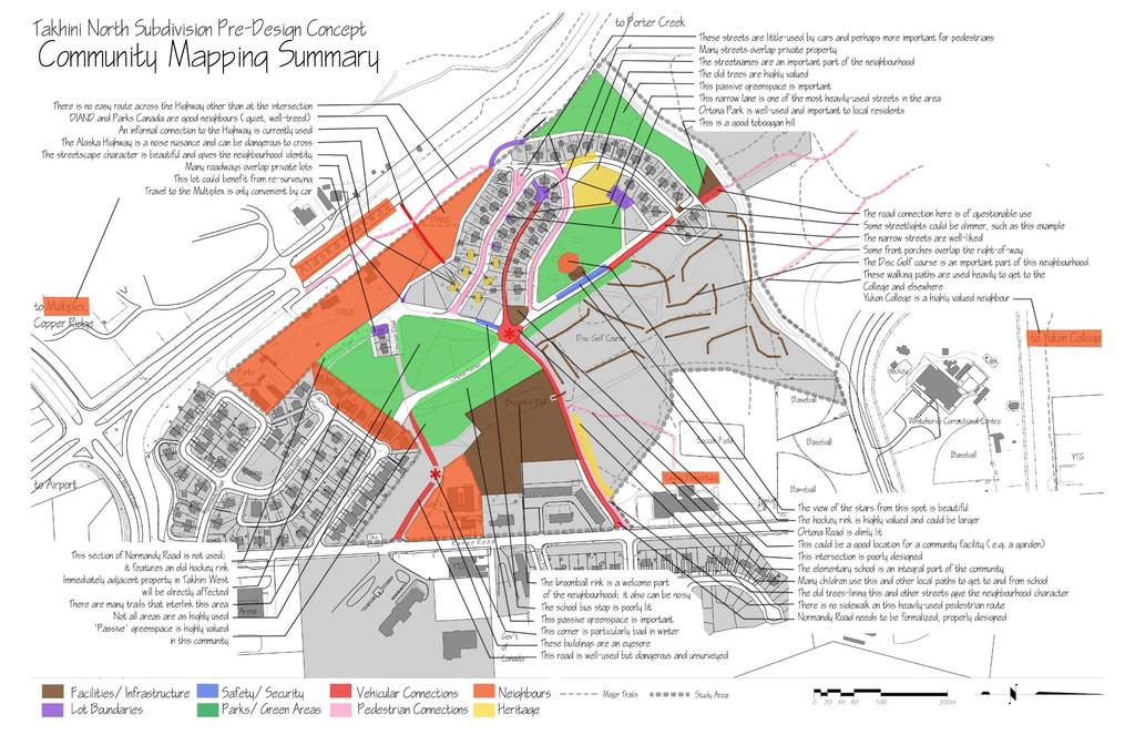
1 Takhini North Subdivision Pre-Design Concept Visioning Workshop Thursday, December 5 th, :30 pm 8:30 pm Takhini Arena Mezzanine Schedule Time Session Facilitators 5:30 5:45pm Arrival, Sign-in 5:45 6:00pm Introduction All 6:00 6:30pm Where we Are Review of Situation Analysis, Consultations, Community Mapping Rick S, Deb P, Mike E 6:30 7:00pm 7:00 7:15pm Break 7:15 8:00pm Finding Common Ground Extracting Common Words, Ideas, Themes, Values Themes to Dreams Translating Values to Vision Deb P, Mike E Deb P, Mike E 8:00 8:30pm Drafting the Vision Statement Deb P, Mike E The Workshop Team includes: Mike Gau, City of Whitehorse Planning Janet Ryan, City of Whitehorse Engineering Deborah Pitt, Inukshuk Planning & Development Mike Ellis, Inukshuk Planning & Development Rick Savage, Quest Engineering Group
2
3 Takhini North Subdivision Pre-design Concept Visioning Workshop Feedback Form Thanks so much for coming tonight! We d appreciate it if you could take a moment to tell us how we did (use the back of the page if you need more space): Did the background material presented at this workshop help you to better understand the different issues and viewpoints? Do you need more information? Did the workshop present a balanced look at the issues and viewpoints? What do you think is the single biggest issue for you, in terms of either the subdivision design process or the public consultation process?

4 See what people are saying about Takhini North
5 The Schools and Day Cares say Having roads re-paved and new sidewalks would be good. Park needs work sand raked out, maybe remove the merry-go-round? The skating rink is well used. Broomball rink in summer is a good place to play hockey it s covered in case of rain. The trails and greenbelts are nice to have. We were hoping to reforest our play area but We lose 5 or 6 pines a year and due to traffic from little feet, there is no re-growth.
6 The Recreation people say Money is in the 2005 budget for upgrades to Ortona Park play equipment. The upper trail is an important link from Porter Creek. The Broomball Association has a proposal in to the City for an expanded lease area. We would like to see the disc golf course retained as is/where is.
7 The Habitat people say The forest is heavily used for recreation. The Significant Wildlife Areas report does not identify this area as key habitat, although the McIntyre Creek area and the escarpment nearby are important. We would be happy to talk to the community about ideas for interpretive signage in the area.
8 The Safety people say Dual access and egress from an area are always a good idea. We occasionally see minor property damage, vandalism to the school. There are no particular safety concerns with trails in the area. One of the safer neighbourhoods in the city. Existing airport noise contour information shows that noise below 30 NEF that occurs in the area may interfere occasionally with certain activities
9 The Servicing people say Access to back alleys makes delivery of home heating oil do-able. People always put the tanks where they can t be seen! The alley behind Normandy is narrow. A bit tricky, but as long as you know where you are going it s not a problem.
10 The Highways people say The highway will likely be widened to 4 lanes in this area in the future it could be 4 lane divided with either wide or raised median. Widening would likely occur on south side of highway due to rock and slope on the north side. The lane encroaches into the highway right-of-way at south end of Arnhem. Off-set entrances onto Range Road are a concern, particularly at the south entrance to the YTG buildings. These should be realigned if possible. Normandy re-alignment may impact school parking lot area.
11 The Community Association says We re a pro-active bunch who want to give knowledgeable direction. Our meetings regarding the sign lacked open dialogue. Garrison Woods in Calgary is an example of new development in a similar area that has been done respectfully. The association is doing a survey to find out what residents want. The Association asked questions of its membership to help identify issues for the Terms of Reference for this project: see the summary attached here
12 The Property Owners say No concerns for the foreseeable future. The greenspace in back of our units is open, some kids in there but it doesn t work very well. People get stuck on the trails/roads in the park area then come and bang on her door We like the idea of a sidewalk along Normandy. We are selling our property so we have no concerns at this time. Our property will devolve to YTG soon, we don t know if there are any future plans.
13 The Property Owners also say I m interested in seeing the area developed a little more. I would like to see things stay the same. A detailed design exists for the development of Prospector Road to the College, it s being looked at in the transportation study. People are informed that the greenspace is City owned, they think of it as a park. The greenspace is a big reason why people choose this area. The previous developer proposed ripping out all the trees and starting fresh this would not go over well with the community. Remainder of the houses should be sold within 2 years.
14 The Property Owners also say What I really like about Takhini North is the atmosphere you really feel like you have left the city when you drive into Takhini North, even though it is actually the geographic centre of Whitehorse. Contributing to this atmosphere are: scale of roads, sidewalks and park, vintage of the streetlights and signs, mature forest areas, winding roads All of the trails and forests in this area create a Central Park for those living in Takhini East, West, North and the trailer court. The paths are also used by trail bicyclists, joggers and many people walking their dogs. There are implications for Kopper King commercial, services need to be sized to handle it.
15 The Property Owners also say The green areas are integral to the neighbourhood. The City has increased taxes from the 82 lots in the area they shouldn t need to develop additional lots/tax revenue in this area. Like the feel of cottage lots. Normandy is main access and is yet unsurveyed. Like to see the lane at the end of Cassino go right through. Need to adjust the rights-of-way to allow for porches that encroach, even if only for small sections. Retaining or emphasizing the street names is a key method for maintaining the flavour of the area.
16 Some Other Comments We are interested in this neighbourhood for a possible co-housing project. Mail service could be changed to rear alleys. Preserve the uniqueness of Takhini North. Less street light (environmentally friendly) or more friendly to night sky. The dilapidated hockey rink is abandoned and creates an eyesore. If infill, please retain original style of housing.
FOCUS AREA 1 - Alberta Avenue Pocket Park 3 (121 Ave and 92 St)
") FOCUS AREA 1 - Alberta Avenue Pocket Park 3 (121 Ave and 92 St) New benches Plant evergreen trees Widen existing sidewalk from 1.5m to 1.8m Marked crosswalk 1.8m wide sidewalk Add pedestrian oriented lights
FOCUS AREA 1 - Alberta Avenue Pocket Park 3 (121 Ave and 92 St) New benches Plant evergreen trees Widen existing sidewalk from 1.5m to 1.8m Marked crosswalk 1.8m wide sidewalk Add pedestrian oriented lights
Comments The Plan for Port Whitby
 Comments The Plan for Port Whitby April 24th, 2013 Community Meeting #2 Summary Report Prepared by GLPi April 29th, 2013 1 Introduction The purpose of the Port Whitby Secondary Plan Update, Community Improvement
FACILITIES PUBLIC FEEDBACK
 FACILITIES PUBLIC FEEDBACK tennis outdoor basketball court camper/rv hook-ups beach area along lake croquet lawn interpretive trails putting green horseshoe pits wellness stations sand volleyball courts
122 Avenue: 107 Street to Fort Road
 : 107 Street to Fort Road November 24, 2015 4:30 8:00 p.m. Meeting Purpose Summarize project work completed to date Share results of public input from Phase 1 Share the draft concept plan and proposed
AGENDA REPORT. Issue: Discussion of potential improvements on Barnwell Road at Niblick Drive
 AGENDA REPORT To: From: By: Honorable Mayor and City Council Members Warren Hutmacher, City Manager Tom Black, Public Works Director Date: March 23, 2016 Agenda: March 28, 2016 WORK SESSION AGENDA: Barnwell
Tonight is for you. Learn everything you can. Share all your ideas.
 Strathcona Neighbourhood Renewal Draft Concept Design Tonight is for you. Learn everything you can. Share all your ideas. What is Neighbourhood Renewal? Creating a design with you for your neighbourhood.
CLOSED. Highlights of the Final Concept Design:
 The final Concept Design is the result of many months of listening, learning, creating, balancing, and understanding different needs and viewpoints, as well as incorporating technical requirements and
Kelowna On the Move. Pedestrian and Bicycle Master Plan
 Kelowna On the Move Pedestrian and Bicycle Master Plan Executive Summary April 2016 Purpose of the Plan The Pedestrian and Bicycle Master Plan identifies infrastructure, planning, and policy requirements
Saskatchewan Drive Roadway Rehabilitation and Shared-Use Path Widening
 Saskatchewan Drive Roadway Rehabilitation and Shared-Use Path Widening We are here today to present the draft plan for the Saskatchewan Drive Roadway Rehabilitation and Shared-Use Path Widening project
ALBERTA AVENUE WHAT WE HEARD REPORT BUILDING GREAT NEIGHBOURHOODS
 ALBERTA AVENUE WHAT WE HEARD REPORT BUILDING GREAT NEIGHBOURHOODS FEBRUARY 2019 EXECUTIVE SUMMARY Starting in 2019, Alberta Avenue will see the replacement and enhancement of its aging collector and local
QUEEN ELIZABETH SCHOOL PARK AND GLENGARRY PARK USAGE SURVEY RESULTS Integrated Strategic Development- Citizen Services- City of Edmonton
 QUEEN ELIZABETH SCHOOL PARK AND GLENGARRY PARK USAGE SURVEY RESULTS 2016 Integrated Strategic Development- Citizen Services- City of Edmonton Introduction Background and Objectives District Parks are busy,
TO: Board Members Vancouver Park Board FROM: General Manager Parks and Recreation SUBJECT: Seaside Greenway Improvements
 Date: October 1, 2013 TO: Board Members Vancouver Park Board FROM: General Manager Parks and Recreation SUBJECT: Seaside Greenway Improvements RECOMMENDATION A. THAT the Board approve the new bike paths
EXECUTIVE SUMMARY. Vision
 Vision Walking and bicycling in Salt Lake City will be safe, convenient, comfortable, and viable transportation options that connect people to places, foster recreational and economic development opportunities,
Montgomery County Life Sciences Center Loop Trail
 Montgomery County Life Sciences Center Loop Trail Advisory Committee Meeting #1 February 10, 2015 Agenda 1. Project Background 2. Existing Conditions Analysis 3. Examples from Elsewhere 4. Discussion Project
San Rafael School District. Task Force Meeting Notes. November 5, 2012
 San Rafael School District Task Force Meeting Notes November 5, 2012 Attendees (8) Wendi Kallins Program Director for Safe Routes to Schools; Laura Kelly Volunteer Liaison for Safe Routes to Schools; Leslie
Clarkson Walkability Audit: Results and Recommendations Summary
 Clarkson Walkability Audit: Results and Recommendations Summary The following document was prepared by the Region of Peel and includes a summary of comments made by participants during our breakout discussion
Building Great Neighbourhoods BELLEVUE AND VIRGINIA PARK
 Building Great Neighbourhoods BELLEVUE AND VIRGINIA PARK This is Meeting 2 Unfortunately, some residents in Bellevue and Virginia Park received the wrong information for this public open house (Meeting
El Paso County 2040 Major Transportation Corridors Plan
 El Paso County 2040 Major Transportation Corridors Plan Connect-our-County Online Transportation User Survey Preliminary Results June 24, 2010 Years of Residence 2. How many years have you LIVED HERE?
2014/2015 BIKE ROUTE PLAN 83 AVENUE PROTECTED BIKE LANE
 About the Project 2014/2015 BIKE ROUTE PLAN The City of Edmonton is planning a major bike route on the south side of Edmonton. This bike route is one part of a plan to provide citizens with transportation
CLOSED. The draft concept design has been broken down into 5 categories for the purpose of this survey:
 Old Strathcona s neighbourhood renewal process is now at the draft concept design phase. Over the last several months, the city has been gathering local knowledge and resident input that has been used
MEDIAN DESIGN example median A
 MEDIAN DESIGN example median A MLK Blvd Design Workshop #3 September 21, 2010 Participants voted on each idea, gave comments about specific ideas or general comments about all ideas. Comments and suggestions
Safe Streets. City of Lake Forest Park. March 21, 2017
 Safe Streets City of Lake Forest Park March 21, 2017 1 01 WELCOME 2 Agenda WELCOME WHAT IS THIS PROJECT? CONTEXT DRAFT CITYWIDE PROJECTS EXERCISE INTRODUCTION 3 02 WHAT IS THIS PROJECT? 4 WHAT IS THIS
MINERAL AVENUE CORRIDOR ASSESSMENT STUDY IMPLEMENTATION STRATEGY
 MINERAL AVENUE CORRIDOR ASSESSMENT STUDY IMPLEMENTATION STRATEGY INTRODUCTION City Personnel Sign-in Sheet Comment Forms Please Write Down Any Feedback INTRODUCTION List of Topics for Presentation Study
MAG Town of Cave Creek Bike Study Task 6 Executive Summary and Regional Significance Report
 Page 1 MAG Town of Cave Creek Bike Study Task 6 Executive Summary and Regional Significance Report August 1, 2012 MAG Project #481 Page 2 Task 6 Executive Summary and Regional Significance Report Introduction
Vision: Traditional hamlet with an attractive business/pedestrian friendly main street connected to adjacent walkable neighborhoods
 N D. Focus Area II Vision: Traditional hamlet with an attractive business/pedestrian friendly main street connected to adjacent walkable neighborhoods Transit Road Focus Area II is located in the Hamlet
WEST AND SOUTH WEST RING ROAD DOWNSTREAM TRAFFIC IMPACTS
 Page 1 of 9 EXECUTIVE SUMMARY Alberta Transportation ( AT ) is preparing to construct the final sections of the Calgary Ring Road. This includes the South West Ring Road ( SWRR ) (from Lott Creek Blvd
City of Sammamish. Welcome. Issaquah-Fall City Road Improvements Project Phase I Design: 242nd Avenue SE to Klahanie Drive SE
 Welcome Welcome to the third community meeting for the Issaquah-Fall City Road Improvements Project. AGENDA 6:00 p.m. Welcome and sign-in 6:10 p.m. Presentation 6:50 p.m. Open house Learn about the roadway
Bank Street Widening Class EA Study Leitrim Road to Rideau Road. Gloucester South Seniors Centre, 4550 Bank Street
 AECOM 302 1150 Morrison Drive 613 820 8282 tel Ottawa, ON, Canada K2H 8S9 613 820 8338 fax www.aecom.com Minutes of Meeting Date of Meeting April 4, 2013 Start Time 6:30 p.m. Project Number 60246226 Project
TRANSPORTATION NEEDS ASSESSMENT
 TRANSPORTATION NEEDS ASSESSMENT A travel demand analysis was carried out to determine the operational issues and the potential benefit that adding traffic capacity would have on the road network. All the
Committed to Service
 Committed to Service Paul Woods, President Rebecca W. Arnold, Vice President Sara M. Baker, Commissioner Jim D. Hansen, Commissioner Kent Goldthorpe, Commissioner March 14, 2017 Planning and Programming
Land Use and Transportation Town Hall September 17, 2018
 Land Use and Transportation Town Hall September 17, 2018 Welcome! Tonight s Agenda: 7:00-7:30 OVERVIEW PRESENTATIONS 7:30-8:15 BREAKOUT SESSIONS 8:15 - End TOWN HALL CITIZEN S TIME Purpose of Tonight s
17 AVE SE BRT Project
 Project overview City Council approved a Transportation Planning Study for 17 Avenue S.E. between Downtown and Stoney Trail East in July 2010 and a complementary land use concept for the 17 Avenue S.E.
Building Great Neighbourhoods LANSDOWNE
 Building Great Neighbourhoods LANSDOWNE We are here today to Explain how the City is investing in improving your neighbourhood and how your neighbourhood will be improved to meet current City standards.
The District Municipality of Muskoka 70 Pine Street Bracebridge ON P1L 1N3
 Public Information Centre Summary Report Muskoka Road 15 (Santa s Village Road) Transportation Improvements from the Beaver Creek Bridge to the Entrance of Santa s Village The District Municipality of
Fields of St. Croix HOA Meeting. October 27, 2016
 Fields of St. Croix HOA Meeting October 27, 2016 Welcome! Why are we here? Update on Manning Avenue Phase 2 Project: Project Design Schedule Project Background Importance of Manning Avenue: Primary north-south
Chapter 3: Multi-Modal Circulation and Streetscapes
 CHAPTER 3: MULTI-MODAL CIRCULATION AND STREETSCAPES Chapter 3: Multi-Modal Circulation and Streetscapes Overview Streetscape improvements have already been completed for Depot Street between Main Avenue
Summaries from the Concentric Circle Exercises 10 Neighborhood Forums held in April and May 2018 Various locations around Town
 Summaries from the Concentric Circle Exercises 10 Neighborhood Forums held in April and May 2018 Various locations around Town A Concentric Circle exercise was conducted at all 10 neighborhood meetings.
DATE: June 22, General Release SUBMITTED BY: LAND DEVELOPMENT SERVICES. RE: City Centre Survey Results
 DATE: June 22, 2018 TO: General Release SUBMITTED BY: LAND DEVELOPMENT SERVICES RE: City Centre Survey Results The following is a summary of preliminary findings for the Community Identity and Vision survey.
50 Avenue S.W. Corridor Study Glenmore Aquatic Centre Drop-In Event
 Project overview The City of Calgary is conducting a transportation corridor study of 5 Avenue S.W., between Crowchild Trail and 4A Street S.W. In 29, it was reclassified as a Parkway under the Calgary
5 CIRCULATION AND STREET DESIGN
 5 CIRCULATION AND STREET DESIGN This chapter describes circulation and streetscape improvements proposed for the Northwest Chico Specific Plan Area. It includes detailed design specifications for existing
TRANSPORTATION COMMISSION Agenda Staff Report
 TRANSPORTATION COMMISSION Agenda Staff Report Agenda Item No. 5.a DATE: JULY 31, 2014 TO: FROM: SUBJECT: TRANSPORTATION COMMISSION COMMUNITY DEVELOPMENT DEPARTMENT - PLANNING DRAFT OLYMPIC CORRIDOR PREFERRED
See Figure 38, Existing Nonmotorized Connections.
 Nonmotorized Connections Existing Nonmotorized Connections Pedestrian, vehicle and bike traffic access and movements are confined primarily to Penny Drive on campus. Due to the steep slope along the length
City of Fairfax, Virginia City Council Work Session
 City of Fairfax, Virginia City Council Work Session Agenda Item # 4b City Council Meeting 6/2/2015 TO: FROM: SUBJECT: ISSUE(S): SUMMARY: FISCAL IMPACT: RECOMMENDATION: ALTERNATIVE COURSE OF ACTION: RESPONSIBLE
2016 Neighborhood Street Fund Application
 2016 Neighborhood Street Fund Application 2016-109 #146 COMPLETE Collector: Web Link 1 (Web Link) Started: Sunday, April 17, 2016 2:29:58 PM Last Modified: Sunday, April 17, 2016 2:36:28 PM Time Spent:
NOTES OF MEETING AIRPORT ROAD (KING STREET TO HUNTSMILL DRIVE) ENVIRONMENTAL ASSESSMENT (EA) COMMUNITY WORKING GROUP (CWG) ORIENTATION SESSION
 ENVIRONMENTAL ASSESSMENT (EA) COMMUNITY WORKING GROUP (CWG) ORIENTATION SESSION") NOTES OF MEETING AIRPORT ROAD (KING STREET TO HUNTSMILL DRIVE) ENVIRONMENTAL ASSESSMENT (EA) COMMUNITY WORKING GROUP (CWG) ORIENTATION SESSION Thursday, November 30, 2017 6:00 p.m. 8:00 p.m. Caledon Community
NOTES OF MEETING AIRPORT ROAD (KING STREET TO HUNTSMILL DRIVE) ENVIRONMENTAL ASSESSMENT (EA) COMMUNITY WORKING GROUP (CWG) ORIENTATION SESSION Thursday, November 30, 2017 6:00 p.m. 8:00 p.m. Caledon Community
Appendix B - Street Sections
 Appendix B - Street Sections 6TH STREET CORRIDOR PLAN STREET SECTIONS The street sections in Appendix B include recommended improvements to streets for North Glenwood. They include existing conditions
Terwillegar Drive Expressway Draft Concept Plan
 Terwillegar Drive Expressway Draft Concept Plan Anthony Henday Drive to Whitemud Drive November 28 5:00-8:00 p.m. December 1 10:00 a.m. - 3:00 p.m. Let s Talk Today you can: Learn about the new direction
Complete Streets. Designing Streets for Everyone. Sarnia
 Complete Streets Designing Streets for Everyone Sarnia Complete Streets ~ Sarnia ~ 2018 Introduction Our City is made up of a network of streets that we use to go for a walk, cycle to work, drive to the
Montgomery County Life Sciences Center. LOOP TRAIL GSSC Implementation Advisory Committee Meeting #2 March 26, 2015
 Montgomery County Life Sciences Center LOOP TRAIL GSSC Implementation Advisory Committee Meeting #2 March 26, 2015 Trail Alternatives GENERAL ASSUMPTIONS Where separated bicycle and pedestrian facilities
Transportation Assessment
 Transportation Assessment Midtown Open House February 10, 2018 Overview Midtown in Focus Overview & Purpose of Today Transportation Assessment overview Summary of Transportation work to date Review & Analysis
CTH M HIGHWAY PROJECT CTH Q to STH 113
 CTH M HIGHWAY PROJECT CTH Q to STH 113 PUBLIC INFORMATIONAL MEETING #3 Wednesday, May 25, 2005 Town of Westport Administration Building 5387 Mary Lake Road 6:00 p.m. to 8:00 p.m. PUBLIC INFORMATIONAL MEETING
WELCOME. Purpose of the Open House. Update you on the project. Present a draft recommended plan. Receive your input
 WELCOME Purpose of the Open House The Town of Smiths Falls has initiated the Beckwith Street Redevelopment Plan that includes the preparation of a streetscape functional design for the renewal of Beckwith
Public Feedback Comments Appendix G. Appendix G. Public Feedback Comments. Virginia Beach Bikeways and Trails Plan 2011 Page G-1
 Public Feedback Comments Virginia Beach Bikeways and Trails Plan 2011 Page G-1 This is a complete collection to date of responses to the feedback survey which was used at public open houses in December
US 1 Express Lanes Public Kick-Off Meeting
 US 1 Express Lanes Project Development & Environment (PD&E) Study Public Kick-Off Meeting September 7 & 8, 2011 Miami Dade County, Florida 1 Presentation Agenda Introduction to MDX Background to PD&E studies
MASTER BICYCLE AND PEDESTRIAN PLAN
 WELCOME! PLEASE FEEL FREE TO REVIEW THE EXHIBITS THE PRESENTATION WILL BEGIN AT 6:00 PM VILLAGE OF NORTHBROOK MASTER BICYCLE AND PEDESTRIAN PLAN DRAFT EXISTING CONDITIONS REPORT AND PUBLIC MEETING WELCOME!
HELM RANCH ROUND 2 - COMMUNITY WORKSHOP AND OPEN HOUSE SUMMARY
 HELM RANCH ROUND 2 - COMMUNITY WORKSHOP AND OPEN HOUSE SUMMARY Tarpey Elementary School, Clovis, CA October 15, 2014 6:30pm-8:30pm OVERVIEW On Wednesday, October 15, 2014, staff from the City of Clovis
CENTENNIAL NEIGHBOURHOODS SECONDARY PLAN STUDY CITY OF HAMILTON SPECIFIC MAP COMMENTS FROM DECEMBER 1st PUBLIC INFORMATION CENTRE #2
 OPTION #2 - MIXED USE MEDIUM DENSITY OPTION #3 - MIXED USE MEDIUM AND HIGH DENSITY Look at other uses besides industrial along Barton Street over the long term. Residential facing waterfront over long
Project Launch Community Meeting 1 Summary
 ConsumersNext: Planning for People and Business at Sheppard and Victoria Park Project Launch Community Meeting 1 Summary Participants Listening to the Overview Presentation Prepared for the City of Toronto
Hamilton Transportation Master Plan. Public Information Centre Three Summary
 Hamilton Transportation Master Plan Public Information Centre Three Summary Table of Contents Introduction 1 Purpose 1 What was Presented? 1 Key Questions: Town Hall Polling 2 Comment Sheet Feedback 10
AGENDA ITEM SUMMARY SPECIAL AGENDA ITEM NO. _1A_
 AGENDA ITEM SUMMARY AGENCY: City Council MEETING DATE: June 25, 2012 DEPARTMENT: Community Dev PREPARED BY: T Spade DEPT. DIR. APPROVAL: MJ CITY MGR. APPROVAL: LR PRESENTED BY: T Spade TITLE: RECEIVE REPORT
AUTOMATED AND ZERO EMISSION VEHICLES HOW THEY MIGHT RESHAPE OUR STREETS
 AUTOMATED AND ZERO EMISSION VEHICLES HOW THEY MIGHT RESHAPE OUR STREETS BACKGROUND: This study is a collaboration between Urban Circus (Visualisation) and Ethos Urban (Urban Design) Ideas were workshopped
City of Springboro Bicycle & Pedestrian Plan
 City of Springboro Bicycle & Pedestrian Plan Public Visioning Workshop Documentation of Input August 24, 2012 List of Figures Public Input A Public Visioning Workshop was held on August 7, 2012 from 6:00
ARLINGTON COUNTY, VIRGINIA
 ARLINGTON COUNTY, VIRGINIA County Board Agenda Item Meeting of October 15, 2016 DATE: October 7, 2016 SUBJECT: Adoption of amendments to the Master Transportation Plan (MTP) to create a new Pedestrian
Project Overview. Rolling Road Widening Fairfax County. Get Involved. Design Public Hearing. Contact Information
 Get Involved VDOT representatives will review and evaluate information received as a result of this meeting. Please fill out the comment sheet provided in this brochure if you have any comments or questions.
UPTOWN REGIONAL BIKE CORRIDORS PROJECT SAN DIEGO ASSOCIATION OF GOVERNMENTS
 UPTOWN REGIONAL BIKE CORRIDORS PROJECT SAN DIEGO ASSOCIATION OF GOVERNMENTS SUMMARY REPORT: COMMUNITY UPDATE MEETING February 6, 2014 6 8:30 p.m. Roosevelt Middle School Library 3366 Park Blvd, San Diego
Sherwood Drive Traffic Circle
 Strathcona County Sherwood Drive Traffic Circle Online Survey Results April 7, 215 I. Executive Summary The Sherwood Drive Traffic Circle Survey was administered in March 215. In total, 2,263 residents
Welcome. Thank you for your interest in the Lewis & Clark Viaduct Concept Study
 Welcome Thank you for your interest in the Lewis & Clark Viaduct Concept Study Please use the arrows in the upper left hand corner to navigate through the presentation. Use the envelope icon to ask a question
Discussion Paper 1 June 2014 Current State of Transportation in Burlington
 Discussion Paper 1 June 2014 Current State of Transportation in Burlington www.burlington.ca/goyourway Discussion Paper 1: Current State of Transportation in Burlington The City of Burlington is developing
Corridor Vision Workshop Summary James Madison Elementary February 22,2018
 Corridor Vision Workshop Summary James Madison Elementary February 22,2018 WHY DEVELOP THIS STUDY? Ogden City is planning for better connectivity and access to jobs and housing. Working with area partners,
Rink users associations. Who we are:
 Rink users associations Presentation to the Planning and Environment Committee of the Vancouver Parks Board Who we are: Represent: Vancouver Minor Hockey Association Vancouver Thunderbirds Minor Hockey
Lee s Summit Road Improvement Study Public Open House June 7, 2007 Summary of Comment Card Responses
 Lee s Summit Road Improvement Study Public Open House June 7, 2007 Summary of Comment Card Responses Introduction At the Lee s Summit Road Improvement Study Public Open House held Thursday, June 7, 2007
Active Transportation Infrastructure Investment A Business Case
 Active Transportation Infrastructure Investment A Business Case In 2016, the Real Estate Foundation awarded the Capital Regional District a $50,000 grant for Shifting Gears: Land Use Change through Active
Byron Avenue. Public Meeting. Thursday June 16, Traffic Calming Design Sherbourne Road to Island Park Drive
 Byron Avenue Traffic Calming Design Sherbourne Road to Island Park Drive Public Meeting Thursday June 16, 2016 Our Lady of Fatima Parish 153 Woodroffe Avenue 6 9pm 1 Project Summary Area Projects Background
Building a Liveable Ottawa 2031 Backgrounder 5: Barrhaven/Riverside South/Leitrim
 Building a Liveable Ottawa 2031 Backgrounder 5: Barrhaven/Riverside South/Leitrim Wards 3 and 22 Official Plan Transportation Master Plan Cycling Plan Pedestrian Plan October 2013 ottawa.ca/liveableottawa
Obey Creek PEDESTRIAN CIRCULATION EAST WEST PARTNERS PEDESTRIAN CIRCULATION CREEK SIDE LANE SLIP STREET SCOTT MURRAY MAIN STREETS EAST/WEST
 THE VILLAGE AT PEDESTRIAN CIRCULATION MAIN STREETS NORTH/SOUTH MAIN STREETS EAST/WEST SLIP STREET CREEK SIDE LANE PEDESTRIAN CIRCULATION DESCRIPTION: Circulation through the downtown of is organized by
Community Workshop #1 Summary October 2017
 Community Workshop #1 Summary October 2017 1 Background Pleasure Point has a unique character and strong community identity. In 2008, the community and the County developed the Pleasure Point Community
SAN FRANCISCO MUNICIPAL TRANSPORTATION AGENCY
 THIS PRINT COVERS CALENDAR ITEM NO. : 11 DIVISION: Sustainable Streets BRIEF DESCRIPTION: SAN FRANCISCO MUNICIPAL TRANSPORTATION AGENCY Approving traffic modifications on Twin Peaks Boulevard between Christmas
ROUTE 81 CORRIDOR STUDY DESIGN CONCEPTS
 RT 81 Corridor Study CLINTON ROUTE 81 CORRIDOR STUDY DESIGN CONCEPTS View north on High Street, with potential improvements to the streetscape Draft Recommendations November 8 th, 2018 TOWN OF CLINTON
Highway 56 Traffic Study Rymal Road to Cemetery Road
 January 31, 2018 6:00 pm 8:00 pm Highway 56 Traffic Study Rymal Road to Cemetery Road City of Hamilton Public Meeting 2 2 Purpose of Public Meeting To review and obtain public input and comments on the
CITY OF HAMILTON PUBLIC WORKS DEPARTMENT Transit Division
 CITY OF HAMILTON PUBLIC WORKS DEPARTMENT Transit Division TO: Chair and Members Public Works Committee COMMITTEE DATE: June 4, 2018 SUBJECT/REPORT NO: WARD(S) AFFECTED: PREPARED BY: SUBMITTED BY: Mountain
Golden s Plan. For the Highway 6 & 93 Corridor
 Golden s Plan For the Highway 6 & 93 Corridor Purpose of the Study Accommodate regional traffic needs on Highways 6 and 93, as defined by the Northwest Quadrant Feasibility Study. Find a solution that
8 Bicycle and Pedestrian Facilities
 8 Bicycle and Pedestrian Facilities 8.1 Existing Facilities The facilities available to walkers and bikers are diverse in the rural ACOG area. Walking and biking are, by their nature, localized modes of
Building Great Neighbourhoods QUEEN ALEXANDRA
 Building Great Neighbourhoods QUEEN ALEXANDRA We are here today to Explain how the City is investing in improving your neighbourhood and how your neighbourhood will be improved to meet current City standards.
PROJECT OBJECTIVES. Improve vehicle capacity for the intersection. Improve pedestrian and bicycle access
 COMMUNITY MEETING Project Update March 15, 2010 Purcellville, Virginia OVERVIEW Project need / objectives Project recap Design elements Proposed improvements Summary of project benefits / next steps PROJECT
1.0 EXECUTIVE SUMMARY
 1.0 EXECUTIVE SUMMARY The Active Transportation Plan is a guide to accomplish the Town s vision for developing a network of sidewalks, on-road bicycle facilities, and trails that allow for safe and convenient
Knox Street Complete Streets Project
 Knox Street Complete Streets Project Meeting Purpose Get community feedback on two conceptual street design options Meeting Agenda Presentation (20 minutes) Project background and schedule Summary of preferences
2014/2015 BIKE ROUTE PLAN 83 AVENUE PROTECTED BIKE LANE
 About the Project The City of Edmonton is planning a major bike route on the southside of Edmonton. The Strathcona Bike Route will connect the communities of Strathcona, Garneau and the University area,
AND GUIDING PRINCIPLES. Boise, Idaho 1997
 USTICK CONCEPT MASTER PLAN AN AND GUIDING PRINCIPLES Boise City Comprehensiv ehensive e Plan Boise, Idaho 1997 GOALS, OBJECTIVES AND POLICIES BOISE CITY ~ NEIGHBORHOOD MASTER PLANS USTICK CONCEPT MASTER
Outer Cape Bicycle & Pedestrian Master Plan. PUBLIC WORKSHOP #2 March 26, 2015
 Outer Cape Bicycle & Pedestrian Master Plan PUBLIC WORKSHOP #2 March 26, 2015 Introductions TODAY S DISCUSSION PRESENTATION: Project Background : Where have we been? Where are we now? Steering Committee
TO: FROM: SUBJECT: RECOMMENDATION REPORT SUMMARY BOARD AUTHORITY
 February 8, 2018 TO: Park Board Chair and Commissioners FROM: General Manager Vancouver Board of Parks and Recreation SUBJECT: Douglas Park Playground Replacement - Construction Contract RECOMMENDATION
City of North Mankato Parks Master Plan 2015 Citizen Input
 Date/Name What park do you visit most? Why? 1/23/15 Bluff and King Arthur 1/23/15 Reserve - It is the closest park to our house and the only park we have access to if we want to walk on a sidewalk/trail
University of Victoria Campus Cycling Plan Terms of Reference. 1.0 Project Description
 University of Victoria Campus Cycling Plan Terms of Reference 1.0 Project Description The Campus Cycling Plan, a first for the University, will provide a comprehensive and coordinated approach to support
City of Brandon Recreation Facilities Master Plan
 2.7 Specialty Recreation (Refer to Map 1F, Page 55) Specialty Recreation combines: Skateboarding, Snowboarding, and BMX Riding. All of these recreation types have specific facility requirements that in
Frome Street Bicycle Route
 The Adelaide City Council invites engagement from the community about Frome Street Bicycle Route Project Summary Adelaide City Council is seeking feedback on design options to construct bicycle facilities
City of Fairfax, Virginia City Council Work Session
 City of Fairfax, Virginia City Council Work Session Agenda Item # WS 4 City Council Meeting 10/03/2017 TO: FROM: SUBJECT: ISSUE(S): Honorable Mayor and Members of City Council Robert Sisson, City Manager
Welcome 78 Ave S.E. Underpass and Road Widening Project Update
 Welcome 78 Ave S.E. Underpass and Road Widening Project Update About the 78 Avenue S.E. Project 69 Avenue S.E. crossing of CP proposed to close to accommodate future CP operations. 78 Avenue S.E. would
Active Transportation Facility Glossary
 Active Transportation Facility Glossary This document defines different active transportation facilities and suggests appropriate corridor types. Click on a facility type to jump to its definition. Bike
Easton Safer Streets - Final Project Report BRISTOL
 - Final Project Report BRISTOL A Sustrans Community Street Design Project in partnership with Bristol City Council February 07 About Sustrans Sustrans makes smarter travel choices possible, desirable and
APPENDIX E Needs Assessment
 APPENDIX E Needs Assessment Active Transportation Needs Assessment Technical Background This appendix provides the technical background supporting the findings presented in Section 3 of the report. Developed
European Student Competition VOICE Vulnerable Road Users Organizations in Cooperation Across Europe
 European Student Competition VOICE Vulnerable Road Users Organizations in Cooperation Across Europe Name of task: Modernization of Grochowska street in Warsaw Area of Grochowska and Minska crossroad Full