2016 Neighborhood Street Fund Application
|
|
|
- Teresa Stone
- 5 years ago
- Views:
Transcription

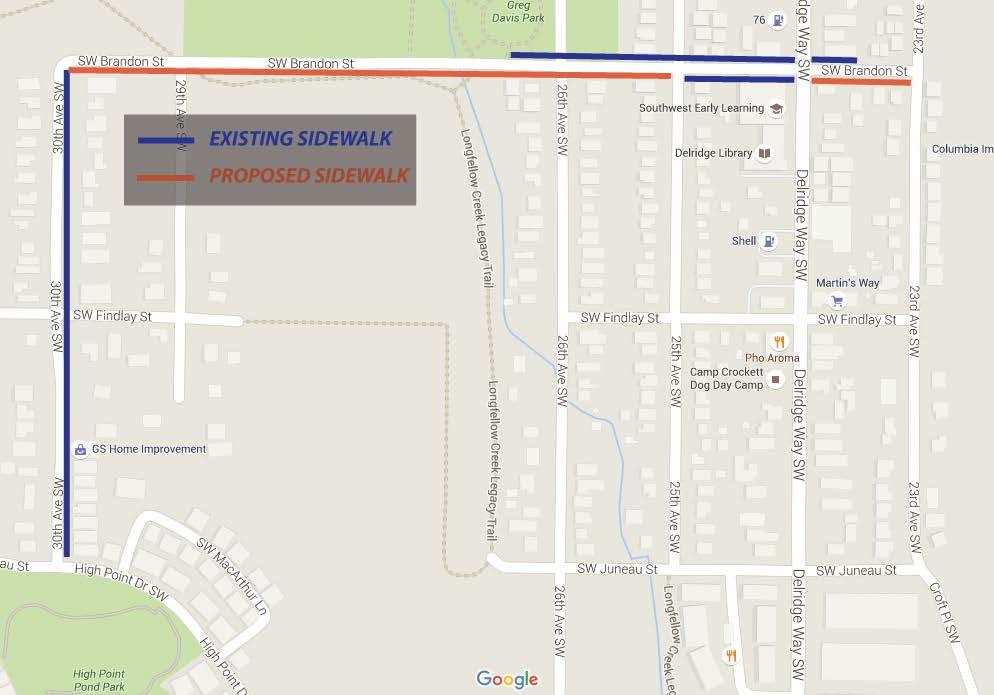
1 2016 Neighborhood Street Fund Application #146 COMPLETE Collector: Web Link 1 (Web Link) Started: Sunday, April 17, :29:58 PM Last Modified: Sunday, April 17, :36:28 PM Time Spent: 00:06:30 IP Address: PAGE 2: Project Information Q1: Do you have a name for your proposed project? Brandon Street Sidewalks - Delridge to High Point Q2: Exactly where is this project? Please name the closest intersection and any other information someone would need to find the location. (Example: on the north side of E Madison St just west of Minor Avenue - in front of the McDonald's) SW Brandon St, between 23rd Ave. SW 25th Ave SW and 30th Ave SW. Q3: What is the problem(s) at this location that you'd like this project to fix?please give as much detail as you can by describing what you experience at this location. Extensive community input during the year-long North Delridge Action Plan ( process identifies improving SW Brandon Street as a high priority.* It is a key element of the community s vision for creating the Brandon Junction, a neighborhood gathering space and business district.* There are no sidewalks on either side of SW Brandon St between 26th and 30th, and between Delridge Way SW and 23rd Ave. SW. In addition, there is no sidewalk on the south side of SW Brandon St between 25th and 26th. SW Brandon St is the only nearby connection between Delridge and High Point for pedestrians, cyclists and motor vehicles and is heavily used by all modes. Pedestrians use this section of Brandon St for travel between Delridge and High Point, to access the heavily used 120 bus on Delridge, and Camp Long, Longfellow Creek and Greg Davis Parks, the Delridge Branch Library and a growing number of residences and businesses. Pedestrians are forced to walk in the street, which is very dangerous given the prevailing auto speeds, the narrow roadway, and the lack of lighting. SW Brandon St and 30th Ave SW are also designated as part of a future Neighborhood Greenway in the recently adopted Bicycle Master Plan ( Google street view, 26th and Brandon looking west: Google street view, Brandon approaching 30th westbound: Google street view, 30th and Brandon looking east, with end of existing sidewalk at 30th visible: Google Street view looking east from Delridge to 23rd Ave SW: In addition to being dangerous for pedestrians, current conditions also encourage dumping, long term vehicle storage, and crime. Making this stretch of roadway accessible for all will help complete the original Olmstead vision for a West Seattle Parkway, as shown on the map on page 3 of the following document: *Information courtesy of David W. Goldberg, Senior Planner, City of Seattle Office of Planning and Community Development 336 / 395
2 2016 Neighborhood Street Fund Application Q4: If you already have a particular solution to the problem, please describe it here.(please note that SDOT staff often need to modify proposed solutions during design development to meet regulations or to adapt to site conditions.) The minimal solution would be to install sidewalks on the south side of SW Brandon St between 25th and 30th Avenues and between Delridge Way SW and SW 23rd St. This would connect the sidewalk built on 30th Ave SW as part of a past NSF project ( with the existing sidewalk east of 25th Ave SW. A map of the location with existing and proposed sidewalks is at This road is flanked by drainage ditches on both sides from 30th to Longfellow Creek. Widening the existing paved street to provide a safe place for foot and bike traffic may be an engineering challenge. Two possibilities are to canalize the drainage on the south side and pave a path defined by a curb over the top. (The north side has old trees that would have to be removed to make way for a foot/bike path). Another possibility is a raised trestle like walkway with a railing to keep pedestrians and bikes separated from the road. The SPU Natural Drainage Systems ( project is evaluating options for adding natural detention facilities in the area along streets, and including new sidewalks where there are none.* It may be possible to add drainage in different locations along SW Brandon St. and allow creative solutions near Longfellow Creek.* There is a pathway to the south of the street in the greenbelt. This path is pretty on sunny days, but dangerous at night in impassible in the rain. If this path were paved, properly drained, widened, lit and marked with proper signage, it might be another alternative for the portion from 30th to the creek. Nature Consortium ( is planning trail restoration work in the vicinity that may offer creative solutions and will improve connections to the Legacy Trail.* Through discussions during the North Delridge Action Plan, Camp Long has expressed an interest in improving trail connection from Brandon/30th corner.* SDOT will be implementing Tactical Urbanism ( improvements at Delridge Way SW and SW Brandon St., and is in the midst of the Delridge Way Multimodal Corridor ( project.* The potential partnerships to increase the benefits of this project by improving connections from Brandon and knitting it into the larger transportation network. They may also bring additional resources - maximizing the positive impacts.* *Information courtesy of David W. Goldberg, Senior Planner, City of Seattle Office of Planning and Community Development Q5: Who is the primary contact for this application? (This will be the individual responsible for answering questions when the proposed project is being considered by your District Council in April/May 2016 and, if selected as one of the 5, evaluated by SDOT staff May - August 2016.) Name Address 1 (optional) City (Optional) State (Optional) Doug Ollerenshaw th Ave SW Seattle WA Zip (Optional) Address Phone Number d.ollerenshaw@gmail.com Q6: Who is the alternative contact for this application? (This person will serve as the primary contact's backup, and will also be included on all correspondence.) Name Organization (optional) Address 1 City State Deborah Vandermar High Point Open Spaces Association 3201 SW Raymond St Seattle WA Zip Address dvandermar@gmail.com Phone Number / 395
3 2016 Neighborhood Street Fund Application PAGE 3: Additional Information Q8: Is anyone within the Seattle Department of Transportation familiar with this problem and proposed solution? Q9: Each District Council will identify 5 projects for further consideration on the basis of their importance to the community. Project applicants are strongly encouraged to work with their District Council to refine their project and to develop understanding of and support for its objectives. Have you involved your District Council on this project? (Please mark as many as apply.) No Applicant(s) attended an SDOT presentation at one of District Council meetings in February or March 2016., Applicant(s) mentioned the project to someone on the appropriate District Council. 338 / 395
4 DOT_NSF From: Sent: To: Cc: Subject: Attachments: Douglas Ollerenshaw Sunday, April 17, :42 PM DOT_NSF Deborah Vandermar Supporting map for "Brandon Street Sidewalks - Delridge to High Point" NSF_DIAGRAM.png Hello, I just submitted an NSF application for sidewalks along Brandon St between Delridge and 30th Ave SW, which leads up to High Point. This application was co-submitted by Deborah Vandermar of the High Point Open Spaces Association. Kerry Wade from the Department of Neighborhoods was aware and supportive of this application. David W. Goldberg, Senior Planner with the City of Seattle Office of Planning and Community Development, provided feedback and supporting information for the application. Please see an attached map detailing the locations of requested sidewalks, as well as existing sidewalks for reference. Links to Google street view images detailing current conditions are included in the application. Please let me know if any further information is required. Thanks, Doug Ollerenshaw 1
5
PRINCE GEORGE S PLAZA METRO AREA PEDESTRIAN PLAN
 PRINCE GEORGE S PLAZA METRO AREA PEDESTRIAN PLAN May 28, 2008 Agenda Welcome and introductions Project overview and issue identification Planning context and strengths Design challenges and initial recommendations
CITY OF SEATTLE RESOLUTION. WHEREAS, the Washington State Department of Transportation (WSDOT) led the Seattle
 led the Seattle") SDOT SR0 Design Refinements RES August, 0 Version #D 0 CITY OF SEATTLE RESOLUTION..title A RESOLUTION relating to the State Route 0, Interstate to Medina Bridge Replacement and High Occupancy Vehicle Project;
SDOT SR0 Design Refinements RES August, 0 Version #D 0 CITY OF SEATTLE RESOLUTION..title A RESOLUTION relating to the State Route 0, Interstate to Medina Bridge Replacement and High Occupancy Vehicle Project;
STONY PLAIN ROAD STREETSCAPE
 Jasper Place Revitalization Strategy: Vision The people involved in the Jasper Place Revitalization Strategy envision: Goal 1: Feeling safe in our community Create a community where feeling safe is common--where
Corpus Christi Metropolitan Transportation Plan Fiscal Year Introduction:
 Introduction: The Safe, Accountable, Flexible, Efficient Transportation Equity Act: A Legacy for Users (SAFETEA-LU) has continued the efforts started through the Intermodal Surface Transportation Efficiency
Agenda. Overview PRINCE GEORGE S PLAZA METRO AREA PEDESTRIAN PLAN
 PRINCE GEORGE S PLAZA METRO AREA PEDESTRIAN PLAN May 28, 2008 Agenda Welcome and introductions Project overview and issue identification Planning context and strengths Design challenges and initial recommendations
Chapter 5 Future Transportation
 Chapter 5 Future Transportation The Future Land Use Plan identifies the desired land use designations. The land uses desired for Crozet depend, in large part, on the success of the transportation system,
Castro Valley Municipal Advisory Council March 19, 2018
 Castro Valley Municipal Advisory Council March 19, 2018 1 Background 2 Draft Bicycle Vision and Pedestrian Networks 3 Next Steps 4 Updates Agenda 2 PROJECT AREA: Unincorporated Areas of Alameda County
122 Avenue: 107 Street to Fort Road
 : 107 Street to Fort Road November 24, 2015 4:30 8:00 p.m. Meeting Purpose Summarize project work completed to date Share results of public input from Phase 1 Share the draft concept plan and proposed
12 RECOMMENDATIONS Road Improvements. Short Term (generally the next five years)
") 12 RECOMMENDATIONS Recommendations are based on the technical analysis of existing and future road and active transportation conditions, the results of the review of existing City policies and public feedback.
12 RECOMMENDATIONS Recommendations are based on the technical analysis of existing and future road and active transportation conditions, the results of the review of existing City policies and public feedback.
2014/2015 BIKE ROUTE PLAN 83 AVENUE PROTECTED BIKE LANE
 About the Project The City of Edmonton is planning a major bike route on the southside of Edmonton. The Strathcona Bike Route will connect the communities of Strathcona, Garneau and the University area,
2014/2015 BIKE ROUTE PLAN 83 AVENUE PROTECTED BIKE LANE
 About the Project 2014/2015 BIKE ROUTE PLAN The City of Edmonton is planning a major bike route on the south side of Edmonton. This bike route is one part of a plan to provide citizens with transportation
City Birmingham Multi-Modal Transportation Plan Visioning Workshop Results Meeting
 City Birmingham Multi-Modal Transportation Plan Visioning Workshop Results Meeting Monday, January 28, 2013 7:30 PM, City Hall Norman Cox, PLA, ASLA. Ann Arbor, Michigan. www.greenwaycollab.com Community
Major Bike Routes 102 Avenue Workshop April 21, 2015
 Major Bike Routes 102 Avenue Workshop April 21, 2015 Our Purpose Today Provide context on how Major Bike Routes fit into Edmonton s future Share information on what we heard in our last phase, and how
Duwamish Way-finding and CTR Report
 V. North Tukwila When the North Tukwila Manufacturing and Industrial Center was designated in 1992 as part of the region s land use and transportation plan, the plan called for the area to set a light-rail
9/21/2016 VIA . RE: The Knot (DR16-270)
") 9/21/2016 VIA EMAIL Garrett Norman, Assistant Planner City of Sacramento Community Development Department 300 Richards Boulevard, 3 rd Floor Sacramento, CA 95811 RE: The Knot (DR16-270) Dear Mr. Norman:
9/21/2016 VIA EMAIL Garrett Norman, Assistant Planner City of Sacramento Community Development Department 300 Richards Boulevard, 3 rd Floor Sacramento, CA 95811 RE: The Knot (DR16-270) Dear Mr. Norman:
4404 St. Peter Street New Orleans, LA (504) April 13 th, To Whom It May Concern:
 April 13 th, To Whom It May Concern:") 4404 St. Peter Street New Orleans, LA 70119 (504) 861-4022 info@bikeeasy.org April 13 th, 2014 To Whom It May Concern: We are writing to present a design solution for Lakeshore Drive. Earlier this month,
4404 St. Peter Street New Orleans, LA 70119 (504) 861-4022 info@bikeeasy.org April 13 th, 2014 To Whom It May Concern: We are writing to present a design solution for Lakeshore Drive. Earlier this month,
Safe Streets. City of Lake Forest Park. March 21, 2017
 Safe Streets City of Lake Forest Park March 21, 2017 1 01 WELCOME 2 Agenda WELCOME WHAT IS THIS PROJECT? CONTEXT DRAFT CITYWIDE PROJECTS EXERCISE INTRODUCTION 3 02 WHAT IS THIS PROJECT? 4 WHAT IS THIS
C C C
 C-012-001 Thank you for your support for the creation of new public space and nonmotorized access between downtown and the waterfront through the Overlook Walk, the East-West Connections, and the Promenade.
COMPLETE STREETS PLANNER S PORTFOLIO
 COMPLETE STREETS PLANNER S PORTFOLIO ISSUE 3 APRIL 2016 PLANNER S PORTFOLIO COMPLETE STREETS 1 2 6 10 14 OVERVIEW MATURE NEIGHBORHOODS GROWING SUBURBS CENTRAL PLACES ACTIVITY CORRIDORS Planner s Portfolio
NACTO Designing Cities 2014 Dongho Chang, City Traffic Engineer October 23, 2014
 NACTO Designing Cities 2014 Dongho Chang, City Traffic Engineer October 23, 2014 Presentation overview Perspective on Safety Changing needs of our cities How Seattle is meeting those needs Challenge for
12/4/2016 VIA . RE: Grocery Outlet Del Paso (DR16-328)
") 12/4/2016 VIA EMAIL Ethan Meltzer, Assistant Planner City of Sacramento Community Development Department 300 Richards Blvd, 3 rd Floor Sacramento, CA 95811 RE: Grocery Outlet Del Paso (DR16-328) Dear Mr.
12/4/2016 VIA EMAIL Ethan Meltzer, Assistant Planner City of Sacramento Community Development Department 300 Richards Blvd, 3 rd Floor Sacramento, CA 95811 RE: Grocery Outlet Del Paso (DR16-328) Dear Mr.
42nd Ave N Reconstruction
 CITY OF MINNEAPOLIS 42nd Ave N Reconstruction Community Meeting #2 May 2016 6:00 7:30 p.m. 5/16/2016 1 Purpose of Meeting Inform: Provide an overview of project, identify anticipated scope of work, and
RapidRide Roosevelt Seat Sea t t le t le Depa De r pa t r men men t of Sept T an r sp an or sp t or a t t a ion
 RapidRide Roosevelt Seattle Bicycle Advisory Board 1 Our mission, vision, and core values Mission: deliver a high-quality transportation system for Seattle Vision: connected people, places, and products
Watertown Complete Streets Prioritization Plan. Public Meeting #1 December 14, 2017
 Watertown Complete Streets Prioritization Plan Public Meeting #1 December 14, 2017 Goals for Public Meeting Overview of MassDOT Complete Streets Funding Program Educate the community on Complete Streets
o n - m o t o r i z e d transportation is an overlooked element that can greatly enhance the overall quality of life for the community s residents.
 N o n - m o t o r i z e d transportation is an overlooked element that can greatly enhance the overall quality of life for the community s residents. 84 Transportation CHAPTER 11 INTRODUCTION Transportation
Public Information Centre
 WELCOME Public Information Centre Father Tobin Road Lougheed Middle School - Library Wednesday November 7, 2012 7:00 p.m.to 9:00 p.m. Please sign in Neighbourhood Traffic Calming Guide Background The City
MAG Town of Cave Creek Bike Study Task 6 Executive Summary and Regional Significance Report
 Page 1 MAG Town of Cave Creek Bike Study Task 6 Executive Summary and Regional Significance Report August 1, 2012 MAG Project #481 Page 2 Task 6 Executive Summary and Regional Significance Report Introduction
WELCOME. Thank you for joining us at the Second Public Workshop for the Carlsbad Pedestrian Master Plan. We look forward to receiving your feedback.
 City of Carlsbad Pedestrian Master Plan: WELCOME WELCOME Please Sign In Provide Input at Flip Charts Review Boards Presentation of Draft Plan Thank you for joining us at the Second Public Workshop for
Pedestrian, Bicycle and Traffic Calming Strategic Implementation Plan. January 18, 2011
 Pedestrian, Bicycle and Traffic Calming Strategic Implementation Plan January 18, 2011 Tonight s Agenda Receive update on project Provide feedback on two policy issues Complete Streets Policy Project Prioritization
CHAPTER 3: Vision Statement and Goals
 Davidson Walks & Rolls: Active Transportation Master Plan CHAPTER 3 Contents: Overview Vision Statement Measurable Goals Public Outreach CHAPTER 3: Vision Statement and Goals Overview The vision statement
01. VICINITY OF GREENBRAE POC: EXISTING CONDITIONS
 01. VICINITY OF GREENBRAE POC: EXISTING CONDITIONS Existing Bus Stop Existing US101 On-ramp Existing POC Old Redwood Highway Rich Street City ROW Environmental Study Limit Industrial Way NO DESIGNATED
Engineering - Bicycle and Pedestrian
 Capital Improvement Plan Project Summary # Bikeways Program 781,000 860,000 900,000 933,000 933,000 933,000 # Cannonball Path 1,200,000-780,000 - - - # Capital City Trail - 70,000 - - 910,000 - # Goodman
Scarlett Road Bridge & Road Improvements Lambton Park Community School - Gymnasium Tuesday November 28 th, 2017
 Scarlett Road Bridge & Road Improvements Lambton Park Community School - Gymnasium Tuesday November 28 th, 2017 PROJECT LOCATION 2 SCARLETT ROAD BRIDGE Constructed in 1912, the bridge carries 4 active
11/28/2016 VIA
 11/28/2016 VIA EMAIL Ethan Meltzer, Assistant Planner City of Sacramento Community Development Department 300 Richards Blvd., 3 rd Floor Sacramento, Ca 95811 RE: Natomas Corporate Center Commercial Building
El Paso County 2040 Major Transportation Corridors Plan
 El Paso County 2040 Major Transportation Corridors Plan Connect-our-County Online Transportation User Survey Preliminary Results June 24, 2010 Years of Residence 2. How many years have you LIVED HERE?
West Dimond Blvd Upgrade Jodhpur Street to Sand Lake Road
 West Dimond Blvd Jodhpur St to Sand Lake CSS Transportation Project Summary Municipality of Anchorage Project # 05 005 Project Manager: John Smith, P.E. (MOA PM&E) Project Administrator: Julie Makela,
Bikeway action plan. Bicycle Friendly Community Workshop March 5, 2007 Rochester, MN
 Bikeway action plan Summary The was held on March 5, 2007 at the Rochester Mayo Civic Center. The workshop was hosted by Rochester-Olmsted County Planning Department in collaboration with the League of
Plant City Walk-Bike Plan
 Plant City Walk-Bike Plan Plant City Commute Mode Share 2.2% 1.4% 2.9% Drove alone 10.2% Carpooled Public transportation (0.1%) Walked Used a Bike (0.4%) 82.9% Taxicab, motorcycle, or other means Worked
Caltrans Sloat Boulevard Pedestrian Safety Project Response to Community Questions, Comments & Concerns
 Caltrans Sloat Boulevard Pedestrian Safety Project Response to Community Questions, Comments & Concerns Revised: May 10, 2016 The California Department of Transportation (Caltrans) is planning various
2011 Capital Projects University Area - Community Council Priority List Municipality of Anchorage
 2011 Capital Projects University Area - Community Council Priority List Municipality of Anchorage 2 Project Management and Engineering Projects on 40th Ave Extension - Lake Otis Pkwy to Dale St $18,103,000
Proposed Bridge Street East Bicycle Lanes Public Open House Thursday, April 27, 2017
 WELCOME Proposed Bridge Street East Bicycle Lanes Public Open House Thursday, April 27, 2017 Purpose of the Open House The purpose of this Open House is to gain public input on the bicycle lanes proposed
CAPITOL DRIVE & FOND DU LAC AVENUE INTERSECTION ANALYSIS. Urban Planning 772 SARAH BREGANT, RYAN PETERSON, & MATT WERDERITCH
 CAPITOL DRIVE & FOND DU LAC AVENUE INTERSECTION ANALYSIS Urban Planning 772 SARAH BREGANT, RYAN PETERSON, & MATT WERDERITCH OVERVIEW N 51 ST BOULEVARD N 51 ST BOULEVARD 12,100 44,700 W CAPITOL DRIVE 52,600
City of Wilsonville 5 th Street to Kinsman Road Extension Project
 City of Wilsonville 5 th Street to Kinsman Road Walking Tour & Neighborhood Workshop Summary Report Public Outreach Overview On July 18 th, 2017, the City of Wilsonville hosted a neighborhood walking tour
KEARNY MESA COMMUNITY PLAN UPDATE
 KEARNY MESA COMMUNITY PLAN UPDATE January 18, 2018 SUBCOMMITTEE MEETING Mobility Concepts and Urban Design Presentation Outline Mobility Concepts: Multimodal Planning Toolbox Presentation and Activities
CONNECTING PEOPLE TO PLACES
 CONNECTING PEOPLE TO PLACES 82 EAST BENCH MASTER PLAN 07 Introduction The East Bench transportation system is a collection of slow moving, treelined residential streets and major arteries that are the
Construction Specifications Manual
 Isle of Wight County Pedestrian and Bicycle Master Plan Construction Specifications Manual Adopted August 20, 2009 Introduction The Isle of Wight County Pedestrian and Bicycle Facilities Master Plan was
El Camino Real Specific Plan. TAC/CAC Meeting #2 Aug 1, 2018
 El Camino Real Specific Plan TAC/CAC Meeting #2 Aug 1, 2018 Land Use Alternatives Goals and Tradeoffs Parks & open space Housing Retail & services Civic spaces Parking Community gathering spaces 3 Alternatives
CHAPTER 1 INTRODUCTION
 CHAPTER 1 INTRODUCTION Chapter Table of Contents THE 2017 HOUSTON BIKE PLAN 1-1 HOUSTON BIKEWAYS PROGRAM 1-2 HISTORY OF BICYCLE PLANNING IN HOUSTON 1-3 BICYCLE LEVEL OF COMFORT 1-3 EXISTING PLANS, PROGRAMS
See Figure 38, Existing Nonmotorized Connections.
 Nonmotorized Connections Existing Nonmotorized Connections Pedestrian, vehicle and bike traffic access and movements are confined primarily to Penny Drive on campus. Due to the steep slope along the length
WELCOME! Please complete a comment sheet as we value your feedback. 4 pm to 8 pm. September 15, Hosted by: AECOM on behalf of City of Calgary
 WELCOME! Thank you for attending our open house. There will be no formal presentation today so please take the time to read the boards. If you have any questions, please do not hesitate to approach one
Lee s Summit Road Improvement Study Public Open House June 7, 2007 Summary of Comment Card Responses
 Lee s Summit Road Improvement Study Public Open House June 7, 2007 Summary of Comment Card Responses Introduction At the Lee s Summit Road Improvement Study Public Open House held Thursday, June 7, 2007
Appendix C 3. Bicycle / Pedestrian Planning
 Appendix C 3. Bicycle / Pedestrian Planning BICYCLE/PEDESTRIAN PLANNING 2005 Master Plan GOAL: Provide for safe and convenient bicycle and pedestrian circulation throughout the City. Develop a city-wide
Southview Blvd & 3 rd Avenue Improvement Project. Public Open House December 4, to 7pm
 Southview Blvd & 3 rd Avenue Improvement Project Public Open House December 4, 2014 5 to 7pm Southview Blvd & 3 rd Avenue Public Information Meeting Agenda Presentation 5:30 to 6:15 pm Purpose of Project
5/7/2013 VIA . RE: University Village Safeway Expansion (P13-019)
") 5/7/2013 VIA EMAIL David Hung, Associate Planner Community Development Department, Current Planning Division City of Sacramento 300 Richards Boulevard, 3 rd Floor Sacramento, CA 95811 RE: University Village
5/7/2013 VIA EMAIL David Hung, Associate Planner Community Development Department, Current Planning Division City of Sacramento 300 Richards Boulevard, 3 rd Floor Sacramento, CA 95811 RE: University Village
Welcome to the Sellwood Bridge Project Open House!
 Welcome to the Sellwood Bridge Project Open House! 5:30 7:30 pm Please sign in here Information stations and project staff are located throughout the room. Goals for Tonight s Meeting: Learn how the Preferred
In station areas, new pedestrian links can increase network connectivity and provide direct access to stations.
 The Last Mile Planning for Pedestrians Planning around stations will put pedestrians first. Making walking to stations safe and easy is important; walking will be a part of every rapid transit Accessible
Community Open House December 13, A project of the Green Infrastructure Center, supported by Skeo Solutions
 Community Open House December 13, 2011 A project of the Green Infrastructure Center, supported by Skeo Solutions Project Background The Green Infrastructure Center, Inc. (GIC) was formed in 2006 to help
Bicycle Pedestrian Master Plan Pre Bid Meeting Portsmouth, NH August 15, 2013
 Bicycle Pedestrian Master Plan Pre Bid Meeting Portsmouth, NH August 15, 2013 2005 Master Plan GOAL: Provide for safe and convenient bicycle and pedestrian circulation throughout the City. Develop a city
Best Southwest Transportation Committee. North Central Texas Council of Governments Transportation Department
 Best Southwest Transportation Committee North Central Texas Council of Governments Transportation Department The The Regional Regional Veloweb Veloweb Review Review NCTCOG Bicycle and Pedestrian Program
Prince George s County plans, policies, and projects
 Prince George s County plans, policies, and projects Over 250 projects for trails, bikeways, designated bike lanes and sidewalk construction Trail projects that improve access to Metro Sidewalk and trail
FOCUS AREA 1 - Alberta Avenue Pocket Park 3 (121 Ave and 92 St)
") FOCUS AREA 1 - Alberta Avenue Pocket Park 3 (121 Ave and 92 St) New benches Plant evergreen trees Widen existing sidewalk from 1.5m to 1.8m Marked crosswalk 1.8m wide sidewalk Add pedestrian oriented lights
FOCUS AREA 1 - Alberta Avenue Pocket Park 3 (121 Ave and 92 St) New benches Plant evergreen trees Widen existing sidewalk from 1.5m to 1.8m Marked crosswalk 1.8m wide sidewalk Add pedestrian oriented lights
Living Streets Policy
 Living Streets Policy Introduction Living streets balance the needs of motorists, bicyclists, pedestrians and transit riders in ways that promote safety and convenience, enhance community identity, create
Non-Motorized Transportation 7-1
 Non-Motorized Transportation 7-1 Transportation facilities no longer mean just accommodating a vehicle powered by a combustion engine. Pedestrian and non-motorized facilities are important modes of travel
City of Sammamish. Welcome. Issaquah-Fall City Road Improvements Project Phase I Design: 242nd Avenue SE to Klahanie Drive SE
 Welcome Welcome to the third community meeting for the Issaquah-Fall City Road Improvements Project. AGENDA 6:00 p.m. Welcome and sign-in 6:10 p.m. Presentation 6:50 p.m. Open house Learn about the roadway
» Draft Recommendations» Discussion» Next Steps. Plan for Walking and Biking
 SAC Meeting Plan #3 for September Walking and 12, Biking 2018 » Draft Recommendations» Discussion» Next Steps Plan for Walking and Biking » Stakeholder and Public Outreach» Background data collection and
3/10/2016 VIA th Street, Suite 203 Sacramento, CA
 3/10/2016 VIA EMAIL Arwen Wacht, Associate Planner City of Sacramento Community Development Department 300 Richards Boulevard, 3 rd Floor Sacramento, CA 95811 RE: Natomas Fountains (P16-012) Dear Ms. Wacht:
Route 29 Solutions Projects
 Route 29 Solutions Route 29 Solutions Projects www.route29solutions.org October 10, 2014 Route 29 Widening to Six Lanes Albemarle County This project will widen a 1.8-mile segment of Route 29 from four
CITY OF COCOA BEACH 2025 COMPREHENSIVE PLAN. Section VIII Mobility Element Goals, Objectives, and Policies
 CITY OF COCOA BEACH 2025 COMPREHENSIVE PLAN Section VIII Mobility Element Goals, Objectives, and Policies Adopted August 6, 2015 by Ordinance No. 1591 VIII MOBILITY ELEMENT Table of Contents Page Number
MASTER BICYCLE AND PEDESTRIAN PLAN
 VILLAGE OF NORTHBROOK MASTER BICYCLE AND PEDESTRIAN PLAN DRAFT PLAN OPEN HOUSE May 2, 2018 AGENDA 1. Community Engagement 2. Vision and Goals 3. General Structure of Plan 4. Recommendations Overview 5.
CONNECTIVITY PLAN. Adopted December 5, 2017 City of Virginia Beach
 CONNECTIVITY PLAN Adopted December 5, 2017 City of Virginia Beach CONTENTS 1.0 Background & Purpose... 2 2.0 Existing Inventory & Analysis... 3 ViBe District Existing Walking Conditions... 4 3.0 ViBe District
Martha Coello, Fairfax County DOT Jeffrey Hermann, Fairfax County DOT Abi Lerner, VDOT. May 19, 2014
 Traforming Tyso From An Auto Oriented Activity Center Into a Multi-Modal Center Martha Coello, Fairfax County DOT Jeffrey Hermann, Fairfax County DOT Abi Lerner, VDOT May 19, 2014 2 11 miles to Dulles
CLOSED. The draft concept design has been broken down into 5 categories for the purpose of this survey:
 Old Strathcona s neighbourhood renewal process is now at the draft concept design phase. Over the last several months, the city has been gathering local knowledge and resident input that has been used
City of Madison: 2017 Capital Budget Capital Improvement Plan
 Capital Improvement Plan Project Summary Bikeways Program 779,000 751,000 630,000 670,000 703,000 703,000 Cannonball Path 210,000 - - 730,000 - - Cap City Trail 1,140,000-360,000 - - 910,000 Ice Age Junction
10.0 CURB EXTENSIONS GUIDELINE
 10.0 CURB EXTENSIONS GUIDELINE Road Engineering Design Guidelines Version 1.0 March 2017 City of Toronto, Transportation Services City of Toronto Page 0 Background In early 2014, Transportation Services
Tonight is for you. Learn everything you can. Share all your ideas.
 Strathcona Neighbourhood Renewal Draft Concept Design Tonight is for you. Learn everything you can. Share all your ideas. What is Neighbourhood Renewal? Creating a design with you for your neighbourhood.
Glebe Neighbourhood Cycling Plan
 Glebe Neighbourhood Cycling Plan Summary of Public Comments received after June 5 th Public Information Session Comment STUDY NETWORK CS9, CS8, E, E0 CS4, E CS4 CS8 E Suggestions for alternate cycling
West End Connectivity Master Plan
 West End Connectivity Master Plan Office of Commissioner Juan C. Zapata District 11 Page 1 of 13 Juan C. Zapata MIAMI- DADE COUNTY COMMISSIONER Introduction I am pleased to announce the West End Connectivity
Building Great Neighbourhoods BONNIE DOON
 Building Great Neighbourhoods BONNIE DOON We Are Here Today To Explain the Neighbourhood Renewal Process Show you the Westwood Preliminary Design Ask for local knowledge Highlight the Local Improvement
Multimodal Through Corridors and Placemaking Corridors
 68 Multimodal Through Corridors and Placemaking Corridors Corridors have different functions in a region. Some corridors are used to get smoothly and rapidly through a region or to get quickly to major
8/31/2016 VIA . RE: Freeport Arco Fuel Station (P16-039)
") 8/31/2016 VIA EMAIL Garrett Norman, Assistant Planner City of Sacramento Community Development Department 300 Richards Boulevard, 3 rd Floor Sacramento, CA 95811 RE: Freeport Arco Fuel Station (P16-039)
8/31/2016 VIA EMAIL Garrett Norman, Assistant Planner City of Sacramento Community Development Department 300 Richards Boulevard, 3 rd Floor Sacramento, CA 95811 RE: Freeport Arco Fuel Station (P16-039)
This page intentionally left blank.
 This page intentionally left blank. COMMUNITY Coweta Community Overview Coweta Coweta, a residential community located in Wagoner County, is a suburb of Tulsa situated southeast of the metropolitan area
WALKNBIKE DRAFT PLAN NASHVILLE, TENNESSEE EXECUTIVE SUMMARY NASHVILLE, TENNESSEE
 NASHVILLE, TENNESSEE EXECUTIVE SUMMARY Executive Summary A world-class multi-modal transportation system is essential to a vibrant city and better quality of life. -Mayor Barry The WalknBike plan aims
MONTGOMERY COUNTY COUNCIL MEMORANDUM
 MONTGOMERY COUNTY COUNCIL R O C K V I L L E, M A R Y L A N D HANS RIEMER COUNCILMEMBER AT-LARGE MEMORANDUM To: T&E Committee From: Councilmember Hans Riemer Date: March 1, 2016 Re: Funding a Protected
Draft North Industrial Area-Wide Traffic Plan
 Summary of North Industrial and Hudson Bay Industrial Recommended Improvements Table 1. Summary of s Item Location 1 2 3 4 5 6 7 8 9 10 11 12 Millar Ave north of 51st St Super 8 Motel back lane 400 Block
Improving Cyclist Safety at the Dundas Street West and Sterling Road Intersection
 STAFF REPORT ACTION REQUIRED Improving Cyclist Safety at the Dundas Street West and Sterling Road Intersection Date: August 17, 2012 To: From: Wards: Reference Number: Public Works and Infrastructure Committee
TOWN OF PORTLAND, CONNECTICUT COMPLETE STREETS POLICY
 TOWN OF PORTLAND, CONNECTICUT COMPLETE STREETS POLICY I. VISION, GOALS & PRINCIPLES VISION To improve the streets of Portland making them safer and more accessible for all users including pedestrians,
GIS Based Data Collection / Network Planning On a City Scale. Healthy Communities Active Transportation Workshop, Cleveland, Ohio May 10, 2011
 The Purpose of GIS Based Network Planning GIS Based Data Collection / Network Planning Healthy Communities Active Transportation Conference Tuesday, May 10, 2011 10:00 AM Norman Cox, LLA, ASLA. Ann Arbor,
Building Great Neighbourhoods QUEEN ALEXANDRA
 Building Great Neighbourhoods QUEEN ALEXANDRA We are here today to Explain how the City is investing in improving your neighbourhood and how your neighbourhood will be improved to meet current City standards.
Pennsylvania Avenue (CR 484) Design Alternatives Study
 Design Alternatives Study") MEMORANDUM Pennsylvania Avenue (CR 484) Design Alternatives Study Prepared for: APRIL 2016 Prepared By TABLE OF CONTENTS Project Background... 2 Previous Concept... 2 Existing Conditions... 4 New Alternatives...
MEMORANDUM Pennsylvania Avenue (CR 484) Design Alternatives Study Prepared for: APRIL 2016 Prepared By TABLE OF CONTENTS Project Background... 2 Previous Concept... 2 Existing Conditions... 4 New Alternatives...
WELCOME Public Information Centre
 WELCOME Public Information Centre Fernforest Drive Brampton Soccer Centre Community Room #2 Tuesday January 19, 2016 6:30 p.m.to 9:00 p.m. Please sign in Neighbourhood Traffic Calming Guide Background
Sixth Line Development - Transit Facilities Plan
 Memorandum Date: November 13, 2012 To: From: c.c. Subject: Rob Freeman (Freeman Planning) Kevin Phillips Sixth Line Development - Transit Facilities Plan 33016631 This memo was prepared to review the transit
City of Seattle Edward B. Murray, Mayor
 City of Seattle Edward B. Murray, Mayor Department of Transportation Scott Kubly, Director Eastlake Community Council 117 E Louisa St. #1 Seattle, WA 98102-3278 January 28, 2016 RE: Roosevelt to Downtown
St. Francis Drive through the City of Santa Fe Corridor Study
 VII. ENGINEERING AND ENVIRONMENTAL EVALUATION TRAIL CONNECTIVITY In the southern portion of the Corridor there is a lack of a sidewalk, trail or bicycle facility within the right-ofway. However, the City
2.0 Existing Conditions
 20 2.0 Existing Conditions 2.1 Land Use, Future Growth Patterns, Physical Barriers Geographic Overview Sutter County s land use pattern is characterized by extensive agricultural areas, significant natural
EXECUTIVE SUMMARY. Vision
 Vision Walking and bicycling in Salt Lake City will be safe, convenient, comfortable, and viable transportation options that connect people to places, foster recreational and economic development opportunities,
Complete Street Analysis of a Road Diet: Orange Grove Boulevard, Pasadena, CA
 Complete Street Analysis of a Road Diet: Orange Grove Boulevard, Pasadena, CA Aaron Elias, Bill Cisco Abstract As part of evaluating the feasibility of a road diet on Orange Grove Boulevard in Pasadena,
Bicycle and Pedestrian Facilities Toolbox (Excerpt from Figure 3.1)
") Appendix B Neighborhood Connections Summaries This Appendix is a supplement to the information presented in Chapter 3 Connect People. The Appendix includes a summary or profile for each of the proposed
Appendix B Neighborhood Connections Summaries This Appendix is a supplement to the information presented in Chapter 3 Connect People. The Appendix includes a summary or profile for each of the proposed
5 Transit & Traffic. Overview
 5 Transit & Traffic Overview Montgomery Place s roadways and overall traffic circulation are unique in the city due to the narrow streets and avenues with boulevards; however, no sidewalks or curbs in
Developing a Bike/Pedestrian Plan Using ArcInfo and Public Participation Rob Shumowsky, Madison County Council of Governments
 Developing a Bike/Pedestrian Plan Using ArcInfo and Public Participation Rob Shumowsky, Madison County Council of Governments Abstract: The Madison County Council of Governments is creating a bike/pedestrian
REGIONAL BICYCLE AND PEDESTRIAN DESIGN GUIDELINES
 REGIONAL BICYCLE AND PEDESTRIAN DESIGN GUIDELINES November 16, 2011 Deb Humphreys North Central Texas Council of Governments Bicycle and Pedestrian Advisory Committee Snapshot of the Guide 1. Introduction