TWITTENS UNDER THREAT SURVEY
|
|
|
- Samantha O’Neal’
- 5 years ago
- Views:
Transcription

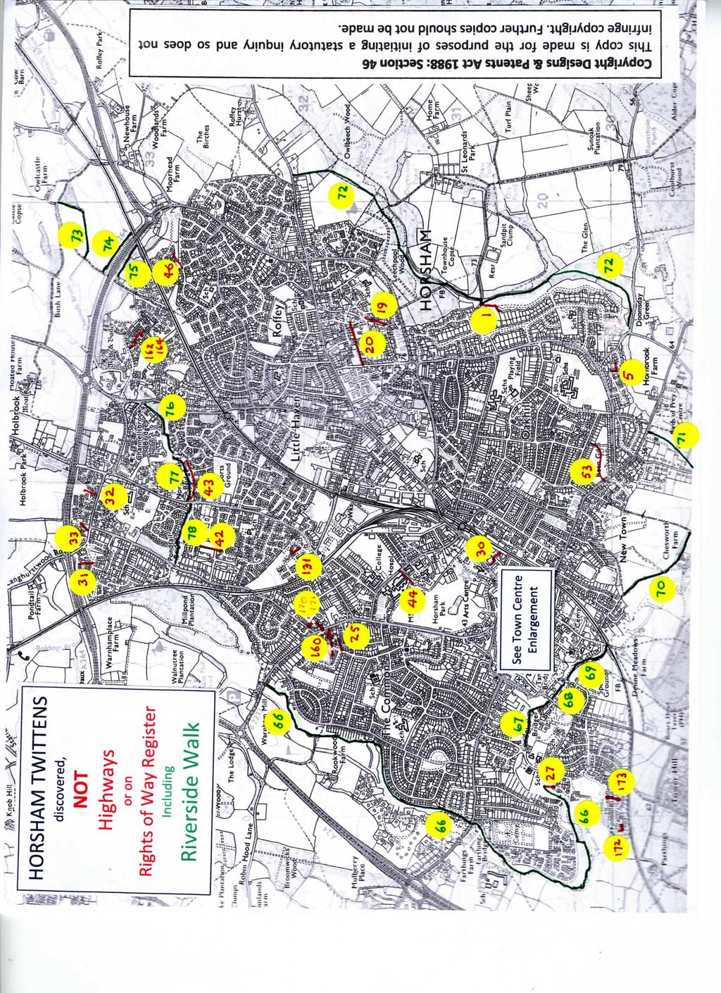
1 HORSHAM TOWN URBAN AREA TWITTENS UNDER THREAT SURVEY FIRST REPORT May 2017 Revised: v5
2 INTRODUCTION The Deregulation Act will trigger the closure in 2026 of the register of definitive maps of rights of way. This is being recognised by The Open Spaces Society, The Ramblers' Association and the British Horse Society who are working to ensure that rural rights of way are shown on the West Sussex County Council s Definitive Map. If they are not on the map the process to do so is very long-winded and could take 10 years to achive if the landowner is uncooperative. Realising that the legislation also applies to urban footpaths, twittens *, alleyways, etc, The Horsham Society has been concerned about these paths in the built-up area of Horsham Town (ie, the unparished area and North Horsham). We have identified over 40 such paths which are neither on the WSCC definitive map nor recognised as highways by the County. Of these, two-thirds are believed to be on land owned by HDC. On the face of it, HDC ownership might imply that these HDC paths are safe against being closed without ceremony but we believe that higher authoriries could change that. It only wants central Government to force District Councils to sell off all their land (think 'Right to Buy'), to find that these paths could be closed overnight in nine years time. For this reason we would like to ask HDC to voluntarily dedicate all the paths which we have found and are on HDC land. Whether on HDC land or not, if we are not to run the risk of losing these old pathways we need to start now on the long process of getting them shown on the definitive map. The next stage is to identify the other owners of the land before contacting them to see if they will voluntarily consent to designation as public rights of way. * Twitten: A narrow path or passage between two walls or hedges [OED]; used in Sussex for a path or alleyway. This survey also includes other paths, footways, alleyways, snickets, etc. ii
3 Schedule of twittens discovered not on definitive Rights of Way (imap) HORSHAM URBAN AREA NOTES: 1: This survey was to discover all twittens, footpaths, adopted highways that provided a route or cut-through from one location to another. It does not include short paths leading only to a single property or a small group of houses. 2: All adopted roads and pathways in Horsham are numbered with WSCC prefix E1760xxxx. 3: FP indicates a footpath on the definitive map. 4: Non-adopted paths and those NOT on the definitive Rights of Way map have a page number indicated in col 1 of the table and further details are on the relevant page of the full report. 5: It should be noted that for this First Report all searches of the Definitive Map and the adopted Highways were of the on-line maps, not those deposited at WSCC offices. Paths believed to be on HDC land are shaded green in the Comments column Denne Neighbourhood Council area paths printed red Forest Neighbourhood Council area paths printed yellow Trafalgar Neighbourhood Council area paths printed blue North Horsham Parish Council area paths printed black Ref Name Start OS Ref Other OS Ref Comment Visited No End 1 Bens Acre TQ Hampers Lane TQ HDC land Dickens Way TQ /10 Gyll Cres TQ HDC land; Street lamps Passageway 19 Market Square TQ Middle St TQ North Passage 25/26 Carfax TQ /19 Piries Pl TQ Possibly HDC land /13 Piries Place TQ Park Place TQ HDC land or HDC Leased West Walk 13/14 West Street TQ Blackhorse Way TQ West Walk Ext Blackhorse Way TQ The Forum TQ Furnaux Walk Parish Off/Sainsbury boundary TQ Bus Station Worthing Rd TQ /63 Manor Fields TQ FP1695 TQ HDC land Earlswood Close TQ Manor Fields TQ HDC recreation ground /96 Trafalgar Road TQ White Hart Court TQ Shandy s Close TQ Arunside TQ Possibly HDC land NCF iv
4 30 Telephone exchange car park TQ North St, Capitol theatre TQ /14 Nuthatch Way TQ Land south of A264 TQ HDC land Pondtail Road TQ Land south of A264 TQ HDC land Pondtail Drive TQ Durfold Road TQ HDC Recreation ground TQ /18 Amundsen Rd TQ HDC land Pondtail Close TQ North Heath Lane TQ Mallow Close TQ HDC land 44 Hosp/Fire Stn, Hurst Rd TQ Horsham Park TQ HDC Amberley Rd/14 Whitehorse Rd TQ /5 Earles Meadow TQ Higgins Way 74/76 Bennetts Road TQ Brighton Road TQ HDC land (Bennetts Field) Wallis Way (end of adopted) TQ Leechpool Lane (school) TQ See path Park Place TQ Park Way TQ Riverside Walk Warnham Road TQ Arunside TQ HDC land Via Guildford Road TQ Riverside Walk Blackbridge Lane TQ Worthing Road TQ HDC land 68 Riverside Walk Worthing Road TQ Mill Bay Lane TQ Homestream House owners 69 Riverside Walk Mill Bay Lane TQ Denne Road TQ HDC land 70A Riverside Walk Chesworth Lane TQ FP1672 TQ HDC Chesworth Farm 70B Riverside Walk FP1672 TQ Kerves Lane TQ HDC Chesworth Farm 71 Riverside Walk KervesLane TQ FP3712 TQ HDC land 72 Riverside Walk Doomsday Green TQ Forest Road TQ HDC land Via Hampers Lane TQ Riverside Walk FP1575, Owlcastle Farm TQ FP1586 TQ Riverside Walk FP1586 TQ A264/Railway underpass TQ Riverside Walk A264/Railway underpass TQ FP1586 TQ HDC land 76 Riverside Walk Rusper Road TQ Chennells Brook TQ HDC land 77 Riverside Walk Chennells Brook TQ North Heath Lane TQ Riverside Walk 2 Cook Road TQ Pondtail Road TQ HDC land 79 Piries Place 4 Piries Place TQ Piries Place TQ HDC Leased (?) land 160 Trafalger Rd Baptist Church TQ Boundary TQ Boundary TQ Fishers Ct, North Parade TQ private Road notice 162 Holbrook Shops & Surgery TQ Ref 164 TQ Lemmington Way TQ Bartholemew Way TQ v
5 Petworth Drive TQ Holbook Shops car park TQ /54 April Close TQ North Parade TQ /46 April Close TQ Pondtail Road TQ Windrum Close TQ Henderson Way TQ Footpath E TQ Near 61 Garanary Way TQ East of Alder Copse vi
6
PAGHAM NEIGHBOURHOOD PLAN INFRASTRUCTURE GROUP
 PAGHAM NEIGHBOURHOOD PLAN INFRASTRUCTURE GROUP SUMMARY OF FINDINGS AND PRIORITIES PARKING There was a high level of response to this topic which included many aspirations to provide car parking near to
James Bateman's Sprink 'Tunnel', Biddulph (Grid Reference SJ )
") Origins James Bateman's development of his Grange Estate around the middle of the Nineteenth Century included a new private woodland walk giving more convenient access towards the settlement of Biddulph
Origins James Bateman's development of his Grange Estate around the middle of the Nineteenth Century included a new private woodland walk giving more convenient access towards the settlement of Biddulph
connectivity through walking and cycling
 active design case study the national forest: connectivity through walking and cycling active design principles in action: 1. ACTIVITY FOR ALL 2. WALKABLE COMMUNITIES 3. CONNECTED WALKING & CYCLING ROUTES
London to Oxford Trek map
 London to Oxford Trek map Route stats: 103.6 km (64.4 miles) with 800 metres of climbing Start time: 08:00-09:00 Checkpoints: Start - Spelthorne Leisure Centre TW18 1AJ Distance: 0km (0m) Leave here by:
September HAWKHURST PARISH COUNCIL Page 1 of 13 SPORTS STRATEGY FINAL
 September 2017 HAWKHURST PARISH COUNCIL Page 1 of 13 SPORTS STRATEGY FINAL Table of Contents EXECUTIVE SUMMARY 3 1. INTRODUCTION 4 2. LOCAL CONTEXT 5 3. OBJECTIVES 7 4. PRIORITIES 8 5. FUNDING OPTIONS
Walk Description. Directions
 Title: Saffron Trail: Battlesbridge to Chelmsford Distance: 14¾ miles Time taken: 6 hours Start Point: Outside the Barge Inn, Battlesbridge OS Explorer Map: 175 & 183 Grid Ref.: TQ 780 947 Transport: Rail:-
Footpaths and walks in the Leckhampton Fields
 APPENDIX 5 Footpaths and walks in the Leckhampton Fields Because of its network of footpaths, the Leckhampton Fields have many different walks. The rich diversity of landscape, hedgerows, trees, streams,
Your guide to safe and considerate cycling in Cambridge, the cycling capital of the UK.
 Your guide to safe and considerate cycling in Cambridge, the cycling capital of the UK. Cambridge is the UK s cycling capital Cycling is fast, it s cheap, it s good for your health and for the environment.
Roads and public rights of way
 Roads and public rights of way This factsheet outlines how the effects of the Proposed Scheme on roads and public rights of way (PRoW) along the line of route would be managed. Version 1.0 Last updated:
Infrastructure Policies
 Infrastructure Policies 1. Primary Healthcare Health facilities in Ashtead comprise, Ashtead Private Hospital, two GP surgeries at Gilbert House and St Stephens, two Dental practices, the Arch and Tudor
A27 Worthing and Lancing: facilities for walking, cycling, and horse riding [nonmotorised
 A27 Worthing and Lancing: facilities for walking, cycling, and horse riding [nonmotorised users (NMUs)] Introduction This note describes our understanding of the needs of Non-Motorised Users (NMUs) as
Site Working Information Card: River Chess, Chesham Lawn Tennis and Squash club, Pednormead End, Chesham, Bucks HP5 2JU Grid Ref: SP
 Site Working Information Card: River Chess, Chesham Lawn Tennis and Squash club, Pednormead End, Chesham, Bucks HP5 2JU Grid Ref: SP 955 013 Chesham Lawn Tennis and Squash Club Pednormead End Chesham,
H&T. H O L L O W E L L & T E E T O N P A R I S H C O U N C I L
 H&T. H O L L O W E L L & T E E T O N P A R I S H C O U N C I L Web site: http://www.hollowellandteeton.org.uk/ Email: pc-clerk@hollowellandteeton.org.uk Re: Hollowell & Teeton Parish Council Mowing Areas
Warfield Neighbourhood Plan: 4.4 Infrastructure
 Warfield Neighbourhood Plan: 4.4 Infrastructure Previously decided Policy headings: Policy WNP16 Transport Impact of Development Policy WNP17 Transport Proposals Policy WNP18 New School Buildings Policy
Road and Street Naming Policy
 Road and Street Naming Policy 13 December 2017 CONTENTS Purpose...1 Scope...1 Road and Street Naming...1 Road and Street Naming Criteria...1 Style Guide for Road and Street Names...1 Approval Delegation...2
QUEENSTOWN LAKES DISTRICT COUNCIL ROAD NAMING POLICY 1 AUGUST 2016
 QUEENSTOWN LAKES DISTRICT COUNCIL ROAD NAMING POLICY 1 AUGUST 2016 1. Policy and Objectives The objective of this policy is to provide a consistent and comprehensive approach to the naming of roads in
MINUTES 2 January 2019
 Dethick, Lea & Holloway Parish Council Chair 2018-19 Councillor I Hooker Telephone: 01629 534393 Clerk to the Parish Council T Walker Tel: 01629 706222 Email: parishclerk@dethickleaandholloway.org.uk Website:
Husthwaite to Byland Abbey
 Husthwaite to Byland Abbey This walk begins with a loop round the village of Husthwaite and continues towards Coxwold along a disused railway line, which is now a right of way. It passes through Coxwold
CHRISTCHURCH AND EAST DORSET Local Plan Review Options Consultation Response Form
 CHRISTCHURCH AND EAST DORSET Local Plan Review Options Consultation Response Form Name Steve Gerry Organisation (if any) North Dorset Trailway Network (reg charity 1145442) Address Line 1 Address Line
Sheetlines. The journal of THE CHARLES CLOSE SOCIETY for the Study of Ordnance Survey Maps. Don t lose your way Jack Cornish
 Sheetlines The journal of THE CHARLES CLOSE SOCIETY for the Study of Ordnance Survey Maps Don t lose your way Jack Cornish Sheetlines, 113 (December 2018), pp13-18 Stable URL: https://s3.eu-west-2.amazonaws.com/sheetlinesarticles/issue113page13.pdf
Tideswell to Castleton
 Tideswell to Castleton 1 Walk summary Length: 14 km, 8.5 miles Maps: OS Explorer OL1 The Peak District - Dark Peak Area, OS Explorer OL24 The Peak District - White Peak Area, OS Landranger 110 Sheffield
Launton to Bicester nature footpath improved
 Launton to Bicester nature footpath improved Published 13 July 2012 An attractive rural footpath linking Launton to Bicester has brought back into use by the council's Countryside team. Staff have improved
S C O T S. Society of Chief Officers of Transportation in Scotland. Dear Ms Johnston. Footway Parking and Double Parking (Scotland) Bill
 Bill") Society of Chief Officers of Transportation in Scotl S C O T S Chair Bill Barker Director of DGFirst Dumfries Galloway Council Cargen Tower Garroch Business Park Garroch Loan Dumfries DG2 8PN Tel No. :-
Society of Chief Officers of Transportation in Scotl S C O T S Chair Bill Barker Director of DGFirst Dumfries Galloway Council Cargen Tower Garroch Business Park Garroch Loan Dumfries DG2 8PN Tel No. :-
Bottesford Parish Neighbourhood Development Plan Summary of Youth Consultation Results
 2015 Bottesford Parish Neighbourhood Development Plan Summary of Youth Consultation Results RCC (Leics and Rutland) March 2015 0 Summary of Youth Consultation Results All (60) pupils within Years 1 & 2
ADOPTED BISHOPS LYDEARD & COTHELSTONE PARISH COUNCIL
 ADOPTED BISHOPS LYDEARD & COTHELSTONE PARISH COUNCIL Clerk to the Council: Mrs M Rousseau, West View, West Bagborough, TA4 3EG Phone: 01823 432 658 Email: clerk@bishopslydeard.org http://www.bishopslydeard.org.uk/
Local Highway Panels Members Guide. 9 Public Rights of Way
 Local Highway Panels Members Guide 9 2 Local Highway Panels (LHP) Members Guide 2016/17 1. Introduction There are 3927km of (PROW) in Essex, and it is one of the most extensive networks in the country.
Devonport City Cycling Network Strategy
 Devonport City Cycling Network Strategy 2010-2013 Devonport City Cycling Network Strategy Introduction In February 2010 a draft master plan for cycleways was presented to the community. The feedback received
ADVICE ON Finding places to ride and carriage drive
 ADVICE ON Finding places to ride and carriage drive 2 If you move into a new area or buy your first horse you will need to find where you can ride or drive safely off-road. You may also decide you want
Parish Council s Comments Planning Reference Land at Ledbury Road, Wellington Heath November 2018
 2018 Planning Reference 184105 - Land at Ledbury Road, Wellington Heath 183936 - Treetops, Horse Road, Wellington Heath 183920 - The Beck, The Common, Wellington Heath 183143/F - Variation to Permission
SCHEME DESIGN AND ENGINEERING
 THE NORTH SOMERSET COUNCIL (SOUTH BRISTOL LINK CLASSIFIED ROAD) SIDE ROADS ORDER 2013 THE NORTH SOMERSET COUNCIL (SOUTH BRISTOL LINK) COMPULSORY PURCHASE ORDER 2013 THE NORTH SOMERSET COUNCIL (SOUTH BRISTOL
Route: Skewsby Foulrice Stearsby
 Route: Skewsby Foulrice Stearsby Distance: 7 miles Map: Explorer: 300 Howardian Hills & Malton Start (OS ref): SE625710 Park in the village of Skewsby. Walk east out of the village to the T-Junction and
Equestrian Access and The British Horse Society
 Equestrian Access and The British Horse Society The British Horse Society is committed to helping you have access to great off-road riding and carriage driving. In this leaflet there are some handy tips
MILTON ROAD LLF PROJECT UPDATE
 Greater Cambridge City Deal MILTON ROAD LLF PROJECT UPDATE 9 th May 2017 Project objectives Comprehensive priority for buses in both directions wherever practicable; Additional capacity for sustainable
The Legal Record of Rights of Way
 Cranborne Chase and West Wiltshire Downs Area of Outstanding Natural Beauty The Legal Record of Rights of Way www.ccwwdaonb.org.uk Who records and manages Rights of Way (RoW)? County Councils have the
REPORT ON TRANSPORT AND PARKING, 2017
 NEIGHBOURHOOD DEVELOPMENT PLAN 2017 REPORT ON TRANSPORT AND PARKING, 2017 COMPILED BY: NEIGHBOURHOOD DEVELOPMENT PLAN STEERING COMMITTEE AND ROLVENDEN PARISH COUNCIL CONSULTANTS: TONY FULLWOOD ASSOCIATES,
CONTENTS. Community Safety Local Housing Good Health Facilities and Services for (and by) Older People... 16
 Older People... 16") ASHINGTON PARISH PLAN 2006 1 CONTENTS Introduction... 3 A Brief History... 3 The Community of Ashington... 4 Previous Village Surveys... 4 Village Survey 2006... 5 Facilities and Services for Young People...
ASHINGTON PARISH PLAN 2006 1 CONTENTS Introduction... 3 A Brief History... 3 The Community of Ashington... 4 Previous Village Surveys... 4 Village Survey 2006... 5 Facilities and Services for Young People...
Uif!Cmbdl!Kvh!bne! Wbsnibn!Qbsl-!Ipstibn-! Wftu!Tvttfy
 Uif!Cmbdl!Kvh!bne! Wbsnibn!Qbsl-!Ipstibn-! Wftu!Tvttfy 7/6!njmft! Djsdvmbs!!!! 3/6!up!4! ipvst 200114 Moderate Terrain Uif!Cmbdl!Kvh!jt!b!hsfbu!upxn!qvc!dfnusfe! bspvne!b!mbshf!cbs!xjui!xppefn!qbnfmmjnh-!
Shepherdswell - Dover
 Shepherdswell - Dover The North Downs Way > Shepherdswell to Dover Introduction This part of the path is slightly different in character from most other parts of the path since it spends much of the time
Bonnie Prince Charlie Walk
 Bonnie Prince Charlie Walk A waymarked route from Ashbourne to Derby to celebrate the 60th anniversary (1995) of the formation of the Ramblers' Association. This route follows the general direction of
keeping Essex informed Your guide to byways byways and motor vehicles
 keeping Essex informed Your guide to byways byways and motor vehicles The advice in this leaflet is for all those wishing to know more about using byways or unsealed roads in vehicles in Essex. There is
BRINKLEY STUD. Dullingham, Newmarket
 BRINKLEY STUD Dullingham, Newmarket BRINKLEY STUD Dullingham, Newmarket Newmarket 4 miles, Cambridge 13 miles, M11 (junction 9) 14 miles, Stansted Airport 32 miles A 133 acre stud farm near Newmarket with
10 SHERFORD Town Code
 Key Fixes (Ref: Masterplan Book, section 4a. Land Use Budget and Key Fixes ) The Town Plan designs and allocates buildings, streets and spaces as accurately as possible in the understandable absence of
Green Streets and Urban Greenways
 127 11 Green Streets and Urban Greenways 11. Green Streets and Urban Greenways 128 11 Green Streets and Urban Greenways Once the traffic-free section of a route has come to an end, then comes the remaining
What are National Parks?
 Honeypot sites What are National Parks? National Parks are protected areas of natural beauty. The areas include mountains, moorland, heathland, woodland and coasts. National Parks are not theme parks they
Appendix 11 Barton Greenway Review
 Appendix 11 Barton Greenway Review Nigel Brigham & Associates A report for 1 Introduction This report is based on fieldwork carried out in 2016 to review the Greenway network around Cambridge as shown
Thornton le Dale Walks
 Thornton le Dale Walks A collection of circular walks in, and around, the village www.visitthorntonledale.co.uk Thornton-le-Dale Traders Forum and Thornton le Dale Parish Council 1 Thornton le Dale Circular
St. John's Sideroad and Leslie Street Trail System Underpasses
 Office of the Clerk John D. Leach Director of Customer and Legislative ServicesfTown Clerk 905-727-3123 ext. 4771 ileach@aurora.ca Town of Aurora 1 00 John West Way, Box 1 000 Aurora, ON L4G 6J1 August
EAST GRINSTEAD MINIBUS ROUTE
 Horsted Keynes (Morning Only) MINIBUS ROUTE Simon 07521 079317 Crowborough Warren Road Horsted Keynes Station Rd Bus Stop Burgess Hill Girls, Junior School 07.25 07.40 08.02 08.03 08.07 EAST GRINSTEAD
Cilgerran Wildlife Park Circular Walk
 Walking embrokeshire Cilgerran Wildlife ark Circular Walk It s good to walk, so why not step out and sample some of the walks your neighbourhood has to offer. This pleasant and interesting walk which starts
Rights of Way Enforcement Procedure for Land Managers
 Rights of Way Enforcement Procedure for Land Managers November 2006 Contents 1. Introduction 2. Infringements 2.1 Disturbance to the surface of a right of way 2.2 Obstructions 2.3 Structures 3. Enforcement
ST. AGNES. you cannot put a time limit on beauty.
 ST. AGNES CIRCULAR WALKS AROUND There are many enjoyable and picturesque walks around St. Agnes most are signposted and are featured on the St. Agnes Mini-guide map. Because most of our footpaths are in
1. We need more business to come into the parish to give greater local employment opportunities Strongly Agree Neither Disagree Strongly No opinion
 Alvechurch Parish Neighbourhood Plan consultations From the Lounge in red. From the Peace Hall, Rowney Green in black. From the Baptist Hall,Alvechurch in blue. NB The number of people responding is given
AD L T r a f f i c a n d H i g h w a y s E n g i n e e r i n g L t d BRIEFING NOTE B4219 COWLEIGH ROAD, STORRIDGE (ADL REF: 3409/09 NOVEMBER 2017)
") AD L T r a f f i c a n d H i g h w a y s E n g i n e e r i n g L t d ADL House, Oaklands Business Park, Armstrong Way, Yate, Bristol, BS37 5NA Tel: 01454 332 100 Fax: 01454 327 983 Email: cad@adltraffic.co.uk
AD L T r a f f i c a n d H i g h w a y s E n g i n e e r i n g L t d ADL House, Oaklands Business Park, Armstrong Way, Yate, Bristol, BS37 5NA Tel: 01454 332 100 Fax: 01454 327 983 Email: cad@adltraffic.co.uk
TORONTO MUNICIPAL CODE CHAPTER 886, FOOTPATHS, PEDESTRIAN WAYS, BICYCLE PATHS, BICYCLE LANES AND CYCLE TRACKS. Chapter 886
 Chapter 886 FOOTPATHS, PEDESTRIAN WAYS, BICYCLE PATHS, BICYCLE LANES AND CYCLE TRACKS 1 886-1. Definitions. 886-2. Paths established. 886-3. Vehicles excluded; exceptions. 886-4. Pedestrian ways established.
LOUTH LOCAL AUTHORITIES. Policy on non Regulatory Road Signage
 1. BACKGROUND LOUTH LOCAL AUTHORITIES Policy on non Regulatory Road Signage 1.1 This policy relates solely to sign/ objects/advertisements placed on Public Roads, footpaths or open spaces and which may
Although the majority of these walks are around country lanes you should still follow the Country Code:-
 With the update of the Parish Plan was a request for details of any Walks around Pillaton The following pages give several walks that I and my wife have done for many years. Please be aware that NONE OF
Summary results of the Binsted Parish Asset Review
 Summary results of the Binsted Parish Asset Review - 2018 Introduction to Parish survey Reasons behind undertaking it Whole parish plan Limitations of survey Expectations of the discussions ongoing Binsted
A future cycle route network for North Staffordshire mb/08/16 Need for a strategy. Existing cycle route network
 Need for a strategy 1. The government s aim is to double cycling levels nationally by 2025 [note 1]. This would bring significant health, environmental, economic and traffic benefits [note 2]. It is widely
This note provides information on the extent of path provision in Scotland and highlights deficiencies in current provision.
 THE PROVISION OF PATHS IN SCOTLAND This note provides information on the extent of path provision in Scotland and highlights deficiencies in current provision. Why are paths important? Paths are important
Danbury Words and pictures by Laurie Page of the Public Rights of Way team at Essex County Council.
 Danbury Words and pictures by Laurie Page of the Public Rights of Way team at Essex County Council. An undulating walk from Danbury village to the bluebells at the National Trust property of Blakes Wood.
Contract for grass and undergrowth cutting in Sheviock Parish 2017/18.
 The Bill Warren Room, Sheviock Memorial Hall, Crafthole, Torpoint, Cornwall, PL11 3DG Clerk: Mrs Linda Coles Telephone: 01503 232996 Email: sheviockpc@btinternet.com Contract for grass and undergrowth
Speed Limit Policy Isle of Wight Council
 APPENDIX B Speed Limit Policy Isle of Wight Council 2009 Contents Section 1 Introduction 1.1 Links with the Local Transport Plan Section 2 Speed Limits on Urban Roads and Residential Areas 2.1 20mph Limits
Phone: Ref No: 06/2018/0884
 Development Directorate Preston City Council Town Hall Lancaster Road Preston PR1 2RL FAO Ben Sandover Phone: 01772 533855 Email: david.allen@lancashire.gov.uk Ref No: 06/2018/0884 Date: 20 September 2018
Thirsk Castle. To begin the walk go to the west of
 Past and Present is a walk around Thirsk and Sowerby to enjoy the town and countryside, but also to learn about local history. It takes in sites of historical and environmental approximately three miles
INFORMATION SHEET NO: B3
 25a Bell Street, Henley-on-Thames RG9 2BA tel: 01491 573535 e-mail: hq@oss.org.uk website: www.oss.org.uk (registered in England and Wales, limited company number 7846516, registered charity number 1144840)
Transport Plan Adopted March 2012
 Burneside Parish Council Transport Plan Adopted March 2012 POLICY AREAS: TP1: Motor Vehicles TP2: Public Transport TP3: Cycling and Pedestrian Routes THE REPORT: 1. Scope of the Plan 2. Background 3. Local
Hascombe and Winkworth Arboretum Downs Link Path, Smithbrook Kilns
 point your feet on a new path Hascombe and Winkworth Arboretum Downs Link Path, Smithbrook Kilns Distance: 18 km=11 miles Region: Surrey Author: RDC easy walking Date written: 7-may-2016 Last update: 30-aug-2018
West Dimond Blvd Upgrade Jodhpur Street to Sand Lake Road
 West Dimond Blvd Jodhpur St to Sand Lake CSS Transportation Project Summary Municipality of Anchorage Project # 05 005 Project Manager: John Smith, P.E. (MOA PM&E) Project Administrator: Julie Makela,
REMOVE BARRIERS TO, ENCOURAGE CREATION OF AND PROVIDE GUIDELINES FOR SAFE ROUTES (ALL DISTRICTS)
") Ordinance 2009-98 AN ORDINANCE OF THE BOARD OF SUPERVISORS OF PIMA COUNTY, ARIZONA; RELATING TO ZONING; AMENDING THE PIMA COUNTY ZONING CODE TITLE 18 BY AMENDING SECTION 18.03.020 (DEFINITIONS) TO ADD
Ordinance 2009-98 AN ORDINANCE OF THE BOARD OF SUPERVISORS OF PIMA COUNTY, ARIZONA; RELATING TO ZONING; AMENDING THE PIMA COUNTY ZONING CODE TITLE 18 BY AMENDING SECTION 18.03.020 (DEFINITIONS) TO ADD
Countryside Walks. 1) Highclere Park Public Walk.
 Highclere Park Public Walk.") 1) Highclere Park Public Walk. Access: From Highclere Estate Main Entrance at Whitway, please note there is no parking on site or access for vehicles. Open: Throughout the year. Description: This footpath
1) Highclere Park Public Walk. Access: From Highclere Estate Main Entrance at Whitway, please note there is no parking on site or access for vehicles. Open: Throughout the year. Description: This footpath
QUEENSTOWN TOWN CENTRE TRANSPORT STRATEGY
 QUEENSTOWN TOWN CENTRE TRANSPORT STRATEGY Consultation Document April 2015 This is a summary of the Draft Strategy, which is on the Council s website at www.qldc.govt.nz The summary is designed as an introduction
Table of Contents City of Shelbyville Unified Development Ordinance
 City of Shelbyville Unified Development Ordinance 2012, Bradley E. Johnson, AICP Table of Contents 1: Ordinance Foundation 1.01 Title... 1-2 1.02 Unified Development Ordinance... 1-2 1.03 Defined Words...
Stakeholder Consultation Survey Proposed Cycle Options on Napa Valley Avenue
 Stakeholder Consultation Survey Proposed Cycle Options on Napa Valley Avenue 1. Are you a resident of Vaughan? Information about the way you travel 2. Do you live or work in the Napa Valley Avenue area
MARKHOUSE ROAD IMPROVEMENTS
 MARKHOUSE ROAD IMPROVEMENTS www.enjoywalthamforest.co.uk Waltham Forest is changing and we want you to be part of it. Thanks to a funding pot of 27million from Transport for London, we re delivering the
SADBERGE PARISH COUNCIL
 SADBERGE PARISH COUNCIL Minutes of the meeting held at 7 p.m. on Tuesday 11 th September 2018 in Sadberge Village Hall Present: Councillors Tate, Best, Heath, Heywood, Schott and Smith In attendance: Councillor
For more information and to buy this book click here ISBN: CICERONE. Guides for walkers, trekkers, mountaineers, climbers and cyclists
 For more information and to buy this book click here ISBN: 9781852845377 CICERONE Guides for walkers, trekkers, mountaineers, climbers and cyclists www.cicerone.co.uk WALK 5 Ouston and Urpeth Distance
Clackamas County Comprehensive Plan
 ROADWAYS The County s road system permits the movement of goods and people between communities and regions, using any of a variety of modes of travel. Roads provide access to virtually all property. They
Summary and Analysis of feedback from the August Bank Holiday Fete 25 August 2014
 Summary and Analysis of feedback from the August Bank Holiday Fete 25 August 2014 Housing and Design Record of Comments from fete School Age Group : No Comments 18 30 Age Group : No Comments 30 60 Age
July 2018 to June 2019
 July 2018 to June 2019 FREE walks led by trained volunteers www.adur-worthing.gov.uk/sport-and-leisure/ play-a-sport/walking Note: The routes of many walks may vary due to ongoing river defence work. Level
414 E GOLF RD DES PLAINES, IL
 NORTHWEST HWY NEW ACCESS ROAD PLANNED GOLF RD WOLF RD 414 E GOLF RD DES PLAINES, IL Focal point of Des Plaines Transit-Oriented Development (TOD) Plan Adjacent to Cumberland Metra Station (Renovation/Expansion
4. Declaration of interests Mrs Erika Booth is an allotment holder and member of the Alveston Allotments Association.
 Minutes of the Meeting Held on 5 th March 2012 at 8.15 p.m. in the Bush Room Present: - Cllrs. Hannah Richmond (HR) (Chairman), Marcus Fry (MF), Steve Blick (SB), John Cutland (JC), Terry Hunt (TH), Mrs
Gainsborough and Fledborough Circular
 Trent Vale Cycle Route TVCR18 Gainsborough and Fledborough Circular Gainsborough Old Hall. One of the biggest and best preserved Medieval Manor Houses in England. Start Point: Gainsborough Marshall s Yard
CHURCH ROAD. Public consultation document TELL US YOUR VIEWS.
 CHURCH ROAD Public consultation document YOUR TELL US VIEWS www.enjoywalthamforest.co.uk CHURCH ROAD Introduction Waltham Forest Council was one of three boroughs to be awarded 27million of funding from
Distance: 14 km=8½ miles or 7 km=4½ miles easy-to-moderate walking
 point your feet on a new path Normandy Distance: 14 km=8½ miles or 7 km=4½ miles easy-to-moderate walking Region: Surrey Author: Botafuego Refreshments: Pirbright, Ash date written: 20-feb-2012 date revised:
Thornton le Dale Walks
 Thornton le Dale Walks A collection of walks in and around the village Thornton le Dale Traders Forum www.visitthorntonledale.co.uk Thornton le Dale Walks Walk 1: Beck Isle Cottage and All Saints Church
Pupil Transportation Child Safety Zone Study
 Pupil Transportation Child Safety Zone Study For Peekskill City School District 1031 Elm Street Peekskill, New York 10566 David Fine Robin Zimmerman Paul Guglielmo Karen Gard Superintendent of Schools
ORDINANCE NO. 14,903
 ORDINANCE NO. 14,903 AN ORDINANCE to amend the Municipal Code of the City of Des Moines, Iowa, 2000, adopted by Ordinance No. 13,827, passed June 5, 2000, as heretofore amended, by repealing and replacing
Improving Thetford Cycling Provision. In and Around Thetford
 Improving Cycling Provision In and Around Thetford Presentation to Thetford Town Council July 2015 About Me Lecturer in Mathematics at the University of East Anglia Keen recreational cyclist Volunteer
APPLICATION FOR ROAD NAME/S. Application Guide and Form
 APPLICATION FOR ROAD NAME/S Application Guide and Form GENERAL INFORMATION An applicant requesting to use Maori names for roads will be directed to consult with the IWI prior to seeking Council approval
The Wincheap Society
 The Wincheap Society s on sections of: Thanington 4th Arm Slip Road, Walking, Cycling & Horse-Riding Assessment & Review Report, by Peter Brett Associates, October 2017, on behalf of Pentland Properties
Risk Assessment for Buggy Users at Corhampton Golf Course
 Risk Assessment for Buggy Users at Corhampton Golf Course The following Risk Assessment applies to all persons using ride on buggies on the course, i.e. Members of the Golf Club, Visitors to the Club and
NOTICE OF MAKING OF ORDERS HIGHWAYS ACT 1980
 NOTICE OF MAKING OF ORDERS HIGHWAYS ACT 1980 NORTH SOMERSET DISTRICT COUNCIL (PART OF FOOTPATH AX 6/15 BLEADON QUARRY, BRIDGE ROAD, BLEADON) PUBLIC PATH EXTINGUISHMENT ORDER NO 13 2012 AND NORTH SOMERSET
High Street, Pulloxhill Consider Representations to Proposed Waiting Restrictions
 Meeting: Delegated Decisions by the Executive Member for Community Services on Traffic Regulation Orders Date: 4 February 2016 Subject: High Street, Pulloxhill Consider Representations to Proposed Waiting
Guidance Notes for Parish Footpath Wardens
 Ramblers Kent Area Guidance Notes for Parish Footpath Wardens Definitions of Public Right of Way: Footpath (FP) For walkers only. Prams, pushchairs or wheelchairs are allowed along a public footpath but
PIMPERNE PARISH COUNCIL. Minutes of the Parish Council meeting held on Wednesday 14th November 2018, at 7.00 p.m. at the Village Hall.
 PIMPERNE PARISH COUNCIL Minutes of the Parish Council meeting held on Wednesday 14th November 2018, at 7.00 p.m. at the Village Hall. PRESENT: Cllrs M. Richley, A. Argles, J. Tanner, T Harman, P.Slocombe
Neighbourhood Development Plan: Ashtead INTRODUCTION 2 SUMMARY CONCLUSION CAR USE AND CONGESTION IN ASHTEAD 4
 CONTENTS Page INTRODUCTION 2 SUMMARY CONCLUSION 3 1.0 CAR USE AND CONGESTION IN ASHTEAD 4 1.1 Car Ownership and Methods of Travel to Work 4 1.2 Traffic Congestion in Ashtead 4 2.0 PARKING FACILITIES AND
Bitterroot Valley Privacy Hamilton, Montana
 Bitterroot Valley Privacy Hamilton, Montana Hunting and Fishing Property bordering the Bitterroot National Forest Mountain views on this 200 +/- acres located just nine miles southeast of Hamilton Cutthroat,
APPENDIX B1. CROSS-REFERENCE GUIDE TO THE OHIO REVISED CODE
 Appendix B1. Cross-Reference Guide to the Ohio Revised Code Page B1-1 APPENDIX B1. CROSS-REFERENCE GUIDE TO THE OHIO REVISED CODE The Ohio Revised Code (O.R.C.) contains many laws which apply to the control
The Discharge of Fire Arms bylaw regulates and prohibits the discharge of firearms within the boundaries of the City of Kelowna.
 SUMMARY: The Discharge of Fire Arms bylaw regulates and prohibits the discharge of firearms within the boundaries of the City of Kelowna. This bylaw is a 'consolidated' version and includes amendments
The Hundred Parishes
 The Hundred Parishes Walks from railway stations number 9 6.4 miles (10kms) from Bishop s Stortford to Stansted Mountfitchet Start: Bishop s Stortford station (Grid Reference TL492209) (ample parking and